Jansson
Map title
Tabula Islandiae Auctore Georgio Carolo Flandro
Author
Jansson
Location shown in map
Iceland
Edition date
Circa 1634
Edition place
Amsterdam
Editor
Jansson
Atlas
Atlantis Maioris Appendix
Price
1100 Euro
State
[mint/EXCELLENT/very good/good/fair/mediocre/poor]
Color
Old colors
Verso
Latin text pag 3
Size
Plate: cm (48 x 37) inches (18.9 x 14.57) Paper: cm (55 x 44) inches (21.65 x 17.32)
Technique
Copper engraving
Note
This map is one of the symbols of the intense rivalry between Jansson and Blaeu. Joris Carl's map was first engraved by Jodocus Hondius II (son of the firm's founder and Jansson's brother-in-law). When Jodocus died in 1629 many of his plates were sold to Willem Blaeu, who added his name to the plates and used them to publish his first atlas in 1630. Angered by the sale, Jansson had the Hondius plates slavishly copied. This plate, which only differs from Blaeu's by the lack of his name under the title, was first issued the same year.
Reference
Wiki
Here for more info
In stock
Available
Info
info@thetreasuremaps.com
Code
#0635
×
![Tabula Islandiae Auctore Georgio Carolo Flandro by Jansson, Iceland, Circa 1634]()
Map title
Insulae Americanae
Author
Jansson
Location shown in map
Florida & Antilles islands
Edition date
1636
Edition place
Amsterdam
Editor
--
Atlas
--
Price
900 Euro
State
[mint/EXCELLENT/verygood/good/fair/mediocre/poor] Professionally restored
Color
Black/white
Verso
Latin text
Size
Plate: cm (50.8 x 38.1) inches (20 x 15) Paper: cm (53.3 x 43.2) inches (20.98 x 17.01)
Technique
Copper engraving
Note
Professionally repaired
Reference
--
Wiki
Here for more info
In stock
Available
Info
info@thetreasuremaps.com
Code
#0344
×
![Insulae Americanae by Jansson, Florida & Antilles islands , 1636]()
Map title
Reipublicae Genuensis Ducatus Et Dominii.
Author
Jansson
Location shown in map
Liguria
Edition date
Circa 1638
Edition place
Amsterdam
Editor
Hondius
Atlas
Atlas sive Cosmographicae meditationes de fabrica mvndi et fabricati figvra
Price
600 Euro
State
[mint/EXCELLENT/very good/good/fair/mediocre/poor]
Color
Old colors
Verso
German text
Size
Plate: cm (49 x 38) inches (19.29 x 14.96) Paper: cm (58 x 51) inches (22.83 x 20.08)
Technique
Copper engraving
Note
Reference
Wiki
Here for more info
In stock
Available
Info
info@thetreasuremaps.com
Code
#1257
×
![Reipublicae Genuensis Ducatus Et Dominii. by Jansson, Liguria, Circa 1638]()
Map title
Indiae Orientalis Nova Descriptio
Author
Jansson
Location shown in map
Southest Asia
Edition date
Circa 1640
Edition place
Amsterdam
Editor
--
Atlas
Novus Atlas
Price
1300 Euro
State
[mint/EXCELLENT/very good/good/fair/mediocre/poor]
Color
Old colors
Verso
Franch text pag. 676
Size
Plate: cm (51 x 39) inches (20.08 x 15.35) Paper: cm (58 x 45) inches (22.83 x 17.72)
Technique
Copper engraving
Note
Reference
--
Wiki
Here for more info
In stock
Sold
Info
info@thetreasuremaps.com
Code
#1211
×
![Indiae Orientalis Nova Descriptio by Jansson, Southest Asia, Circa 1640]()
Map title
Riviera di Genova di Levante
Author
Jansson
Location shown in map
Liguria
Edition date
Circa 1640
Edition place
Editor
Atlas
Price
500 Euro
State
[mint/excellent/VERY GOOD/good/fair/mediocre/poor]
Color
Old colors
Verso
German text
Size
Plate: cm (50 x 39) inches (19.69 x 15.35) Paper: cm (55 x 44) inches (21.65 x 17.32)
Technique
Copper engraving
Note
Reference
Wiki
Here for more info
In stock
Available
Info
info@thetreasuremaps.com
Code
#1283
×
![Riviera di Genova di Levante by Jansson, Liguria, Circa 1640]()
Map title
Capitanata olim Mesapiae et Iapigiae pars
Author
Jansson
Location shown in map
Puglia
Edition date
Circa 1640
Edition place
Amsterdam
Editor
Atlas
Atlas Novus
Price
200 Euro
State
[mint/excellent/very good/good/fair/mediocre/POOR]
Color
Old colors
Verso
Latin text
Size
Plate: cm (49 x 37) inches (19.29 x 14.57) Paper: cm (55 x 44) inches (21.65 x 17.32)
Technique
Copper engraving
Note
Reference
Wiki
Here for more info
In stock
Available
Info
info@thetreasuremaps.com
Code
#1294
×
![Capitanata olim Mesapiae et Iapigiae pars by Jansson, Puglia, Circa 1640]()
Map title
Regni Daniae
Author
Jansson
Location shown in map
Denmark
Edition date
Circa 1647
Edition place
Amsterdam
Editor
Atlas
Price
400 Euro
State
[mint/EXCELLENT/very good/good/fair/mediocre/poor]
Color
Old colors
Verso
Latin text
Size
Plate: cm (56 x 45) inches (22.05 x 17.72) Paper: cm (58 x 49) inches (22.83 x 19.29)
Technique
Copper engraving
Note
Reference
Wiki
Here for more info
In stock
Available
Info
info@thetreasuremaps.com
Code
#1311
×
![Regni Daniae by Jansson, Denmark, Circa 1647]()
Map title
Orbis Terrarum Veteribus Cogniti Typus Geographicus
Author
Jansson
Location shown in map
World
Edition date
Circa 1650
Edition place
Amsterdam
Editor
Janssonius
Atlas
Atlas
Price
600 Euro
State
[mint/EXCELLENT/verygood/good/fair/mediocre/poor]
Color
Old colors
Verso
Latin
Size
Plate: cm (49.5 x 39.4) inches (19.49 x 15.51) Paper: cm (58.4 x 48.3) inches (22.99 x 19.02)
Technique
Copper engraving
Note
--
Reference
--
Wiki
Here for more info
In stock
Available
Info
info@thetreasuremaps.com
Code
#0599
×
![Orbis Terrarum Veteribus Cogniti Typus Geographicus by Jansson, World, Circa 1650]()
Map title
Germaniae veteris nova descriptio
Author
Jansson
Location shown in map
Germany
Edition date
1652
Edition place
Amsterdam
Editor
--
Atlas
Accuratissima orbis antiqui delineatio.
Price
250 Euro
State
[mint/excellent/VERY GOOD/good/fair/mediocre/poor]
Color
Black/white
Verso
Blank
Size
Plate: cm (47 x 36.8) inches (18.5 x 14.49) Paper: cm (54.6 x 45.7) inches (21.5 x 17.99)
Technique
Copper engraving
Note
Map based on Ortelius' map of ancient Germany.
Reference
--
Wiki
Here for more info
In stock
Available
Info
info@thetreasuremaps.com
Code
#0138
×
![Germaniae veteris nova descriptio by Jansson, Germany, 1652]()
Map title
Sinus Gangeticus Vulgo Golfo De Bengala Nova descriptio
Author
Jansson
Location shown in map
India
Edition date
Circa 1670
Edition place
Amsterdam
Editor
Schenk
Atlas
Novus Atlas
Price
450 Euro
State
[mint/EXCELLENT/very good/good/fair/mediocre/poor] repaired
Color
Old colors
Verso
Blank
Size
Plate: cm (54 x 50) inches (21.26 x 19.69) Paper: cm (54 x 49) inches (21.26 x 19.29)
Technique
Copper engraving
Note
Reference
Wiki
Here for more info
In stock
Available
Info
info@thetreasuremaps.com
Code
#1200
×
![Sinus Gangeticus Vulgo Golfo De Bengala Nova descriptio by Jansson, India, Circa 1670]()
Map title
Genuense Territorium
Author
Jansson
Location shown in map
Genuense Territorium
Edition date
1673
Edition place
Amsterdam
Editor
--
Atlas
Atlas Minor
Price
250 Euro
State
[mint/EXCELLENT/very good/good/fair/mediocre/poor]
Color
Old colors
Verso
Blank
Size
Plate: cm (24 x 18) inches (9.45 x 7.09) Paper: cm (27 x 20) inches (10.63 x 7.87)
Technique
Copper engraving
Note
Reference
Wiki
Here for more info
In stock
Available
Info
info@thetreasuremaps.com
Code
#1180
Genuense Territorium
Author
Jansson
Location shown in map
Genuense Territorium
Edition date
1673
Edition place
Amsterdam
Editor
--
Atlas
Atlas Minor
Price
250 Euro
State
[mint/EXCELLENT/very good/good/fair/mediocre/poor]
Color
Old colors
Verso
Blank
Size
Plate: cm (24 x 18) inches (9.45 x 7.09) Paper: cm (27 x 20) inches (10.63 x 7.87)
Technique
Copper engraving
Note
Reference
Wiki
Here for more info
In stock
Available
Info
info@thetreasuremaps.com
Code
#1180
×
![Genuense Territorium by Jansson, Genuense Territorium, 1673]()
Map title
Poli Artici
Author
Jansson
Location shown in map
Polar
Edition date
1673
Edition place
Amsterdam
Editor
--
Atlas
Atlas Minor
Price
300 Euro
State
[mint/excellent/very good/good/FAIR/mediocre/poor]
Color
Old colors
Verso
Blank
Size
Plate: cm (26 x 20) inches (10.24 x 7.87) Paper: cm (24 x 18) inches (9.45 x 7.09)
Technique
Copper engraving
Note
Reference
Wiki
Here for more info
In stock
Available
Info
info@thetreasuremaps.com
Code
#1186
×
![Poli Artici by Jansson, Polar, 1673]()
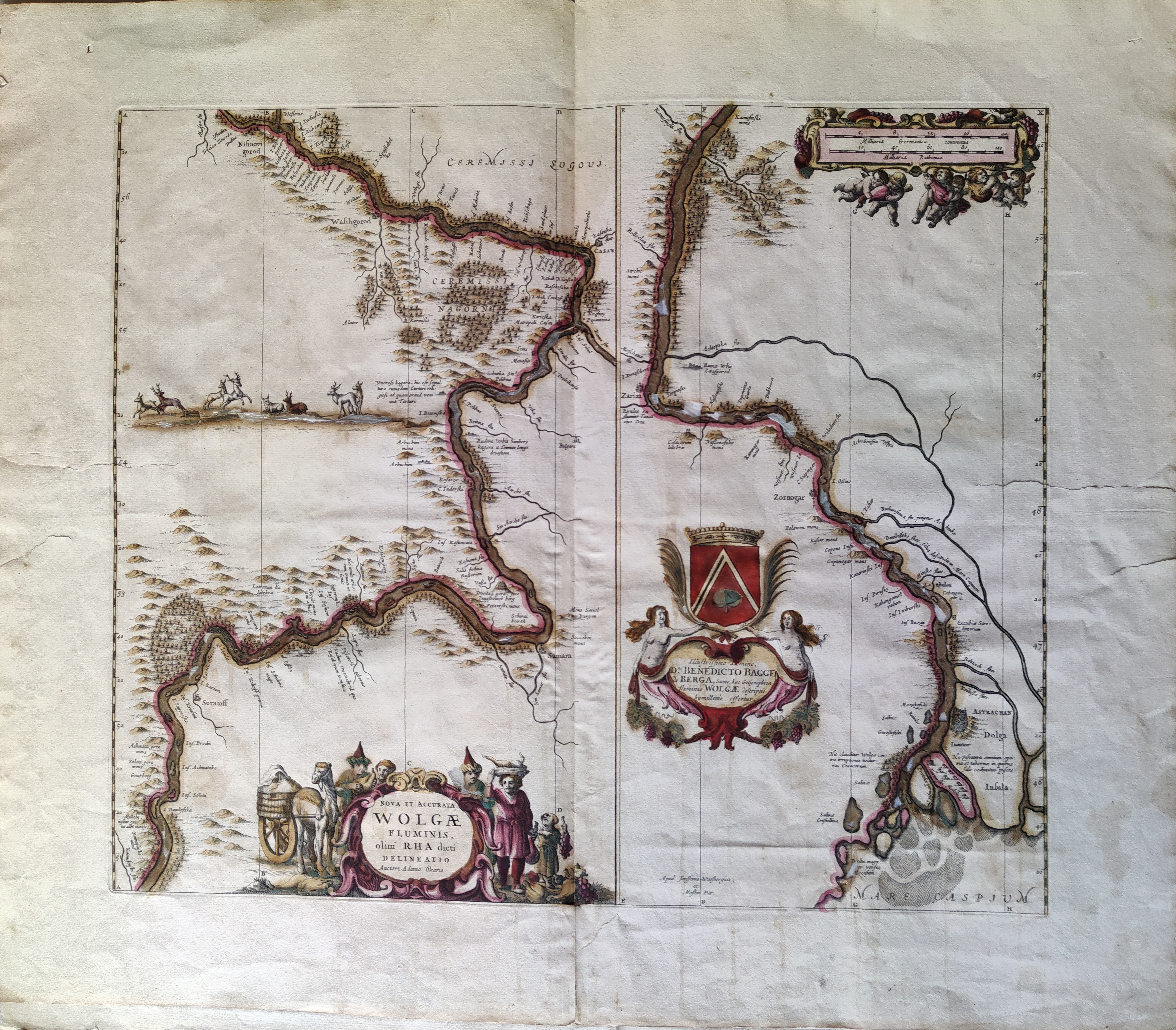
Map title
Nova et Accurata Wolgae Fluminis, Olim Rha Dicti Delineatio Auctore Adamo Oleario
Author
Jansson
Location shown in map
Russia
Edition date
Circa 1680
Edition place
Amsterdam
Editor
Jansson
Atlas
Price
400 Euro
State
[mint/excellent/very good/good/fair/MEDIOCRE/poor]
Color
Old colors
Verso
Size
Plate: cm (54 x 47) inches (21.26 x 18.5) Paper: cm (70 x 60) inches (27.56 x 23.62)
Technique
Copper engraving
Note
Reference
Wiki
Here for more info
In stock
Available
Info
info@thetreasuremaps.com
Code
#1076
×
![Nova et Accurata Wolgae Fluminis, Olim Rha Dicti Delineatio Auctore Adamo Oleario by Jansson, Russia, Circa 1680]()