Munster
Pages: 1 2
Map title
Tabula Europae X
Author
Munster
Location shown in map
Greece
Edition date
1540
Edition place
Basel
Editor
Henrich Petri
Atlas
Geographia
Price
300 Euro
State
[mint/EXCELLENT/very good/good/fair/mediocre/poor]
Color
Black/white
Verso
Latin text pag.12
Size
Plate: cm (31.8 x 25.4) inches (12.52 x 10) Paper: cm (38.1 x 30.5) inches (15 x 12.01)
Technique
Woodcut
Note
No particular notes for this maps
Reference
--
Wiki
Here for more info
In stock
Available
Info
info@thetreasuremaps.com
Code
#0093
×
![Tabula Europae X by Munster, Greece, 1540]()
Map title
Tabula Asiae V
Author
Munster
Location shown in map
Iran and Iraq
Edition date
1540
Edition place
Basel
Editor
Henrich Petri
Atlas
Geographia
Price
300 Euro
State
[mint/EXCELLENT/very good/good/fair/mediocre/poor]
Color
Black/white
Verso
Latin text pag.21
Size
Plate: cm (34.3 x 25.4) inches (13.5 x 10) Paper: cm (38.1 x 30.5) inches (15 x 12.01)
Technique
Woodcut
Note
Ptolemaic map of the region between the Caspian Sea and the Persian Gulf. Numerous ancient cities including Babylon.
Reference
--
Wiki
Here for more info
In stock
Available
Info
info@thetreasuremaps.com
Code
#0175
×
![Tabula Asiae V by Munster, Iran and Iraq, 1540]()
Map title
Tabula Asiae VIII
Author
Munster
Location shown in map
Central Asia
Edition date
1540
Edition place
Basel
Editor
Henrich Petri
Atlas
Geographia
Price
600 Euro
State
[mint/EXCELLENT/very good/good/fair/mediocre/poor]
Color
Black/white
Verso
Latin text pag.24
Size
Plate: cm (34.3 x 25.4) inches (13.5 x 10) Paper: cm (38.1 x 30.5) inches (15 x 12.01)
Technique
Woodcut
Note
Central Asia North of India. Showing in the margin on either side three different imaginary human congenital malformations, as well as a one legged bird.
Reference
--
Wiki
Here for more info
In stock
Available
Info
info@thetreasuremaps.com
Code
#0174
×
![Tabula Asiae VIII by Munster, Central Asia, 1540]()
Map title
--
Author
Munster
Location shown in map
Italy
Edition date
1540
Edition place
Basel
Editor
Henrich Petri
Atlas
Geographia Universalis
Price
1200 Euro
State
[mint/EXCELLENT/very good/good/fair/mediocre/poor]
Color
Black/white
Verso
Latin text pag.43
Size
Plate: cm (33 x 25) inches (12.99 x 9.84) Paper: cm (40 x 31) inches (15.75 x 12.2)
Technique
Woodcut
Note
First edition
Reference
R.Borri L'Italia nelle antiche carte pag.50
Wiki
Here for more info
In stock
Available
Info
info@thetreasuremaps.com
Code
#1293
×
![-- by Munster, Italy, 1540]()

Map title
Hispania Nova Tabula
Author
Munster
Location shown in map
Spain
Edition date
1542
Edition place
Basel
Editor
Henrich Petri
Atlas
Geographia
Price
Please ask: info@thetreasuremaps.com
State
[mint/excellent/VERY GOOD/good/fair/mediocre/poor]
Color
Original colors
Verso
Latin text pag.31
Size
Plate: cm (34.3 x 25.4) inches (13.5 x 10) Paper: cm (38.1 x 30.5) inches (15 x 12.01)
Technique
Woodcut
Note
No particular notes for this maps
Reference
--
Wiki
Here for more info
In stock
Sold
Info
info@thetreasuremaps.com
Code
#0092
×
![Hispania Nova Tabula by Munster, Spain, 1542]()
Map title
--
Author
Munster
Location shown in map
Italy
Edition date
1542
Edition place
Basel
Editor
Henrich Petri
Atlas
Geographia Universalis
Price
700 Euro
State
[mint/EXCELLENT/very good/good/fair/mediocre/poor]
Color
Black/white
Verso
Latin text pag.43
Size
Plate: cm (33 x 25) inches (12.99 x 9.84) Paper: cm (40 x 32) inches (15.75 x 12.6)
Technique
Woodcut
Note
Reference
R.Borri L'Italia nelle antiche carte pag.50
Wiki
Here for more info
In stock
Available
Info
info@thetreasuremaps.com
Code
#0933
×
![-- by Munster, Italy, 1542]()
Map title
Tabula Asiae IX
Author
Munster
Location shown in map
Pakistan
Edition date
1542
Edition place
Basel
Editor
Henrich Petri
Atlas
Geographia
Price
250 Euro
State
[mint/excellent/VERY GOOD/good/fair/mediocre/poor]
Color
Black/white
Verso
Latin text pag.21
Size
Plate: cm (33 x 25.4) inches (12.99 x 10) Paper: cm (38.1 x 30.5) inches (15 x 12.01)
Technique
Woodcut
Note
Ptolemaic map of the region between the Caspian Sea and the Persian Gulf. Numerous ancient cities including Babylon.
Reference
--
Wiki
Here for more info
In stock
Available
Info
info@thetreasuremaps.com
Code
#0176
×
![Tabula Asiae IX by Munster, Pakistan, 1542]()
Map title
Aphricae Tabula III
Author
Munster
Location shown in map
Egypt
Edition date
1545
Edition place
Basel
Editor
Henrich Petri
Atlas
Cosmographia Universalis
Price
200 Euro
State
[mint/EXCELLENT/very good/good/fair/mediocre/poor]
Color
Black/white
Verso
Latin text pag.15
Size
Plate: cm (34.3 x 25.4) inches (13.5 x 10) Paper: cm (38.1 x 30.5) inches (15 x 12.01)
Technique
Woodcut
Note
--
Reference
--
Wiki
Here for more info
In stock
Sold
Info
info@thetreasuremaps.com
Code
#0507
×
![Aphricae Tabula III by Munster, Egypt, 1545]()
Map title
Tabula Europae VIII
Author
Munster
Location shown in map
Russia
Edition date
1545
Edition place
Basel
Editor
Henrich Petri
Atlas
Cosmographia Universalis
Price
Please ask: info@thetreasuremaps.com
State
[mint/excellent/VERY GOOD/good/fair/mediocre/poor]
Color
Black/white
Verso
Latin text pag.10
Size
Plate: cm (33 x 25.4) inches (12.99 x 10) Paper: cm (40.6 x 30.5) inches (15.98 x 12.01)
Technique
Woodcut
Note
No particular notes for this maps
Reference
--
Wiki
Here for more info
In stock
Sold
Info
info@thetreasuremaps.com
Code
#0094
×
![Tabula Europae VIII by Munster, Russia, 1545]()
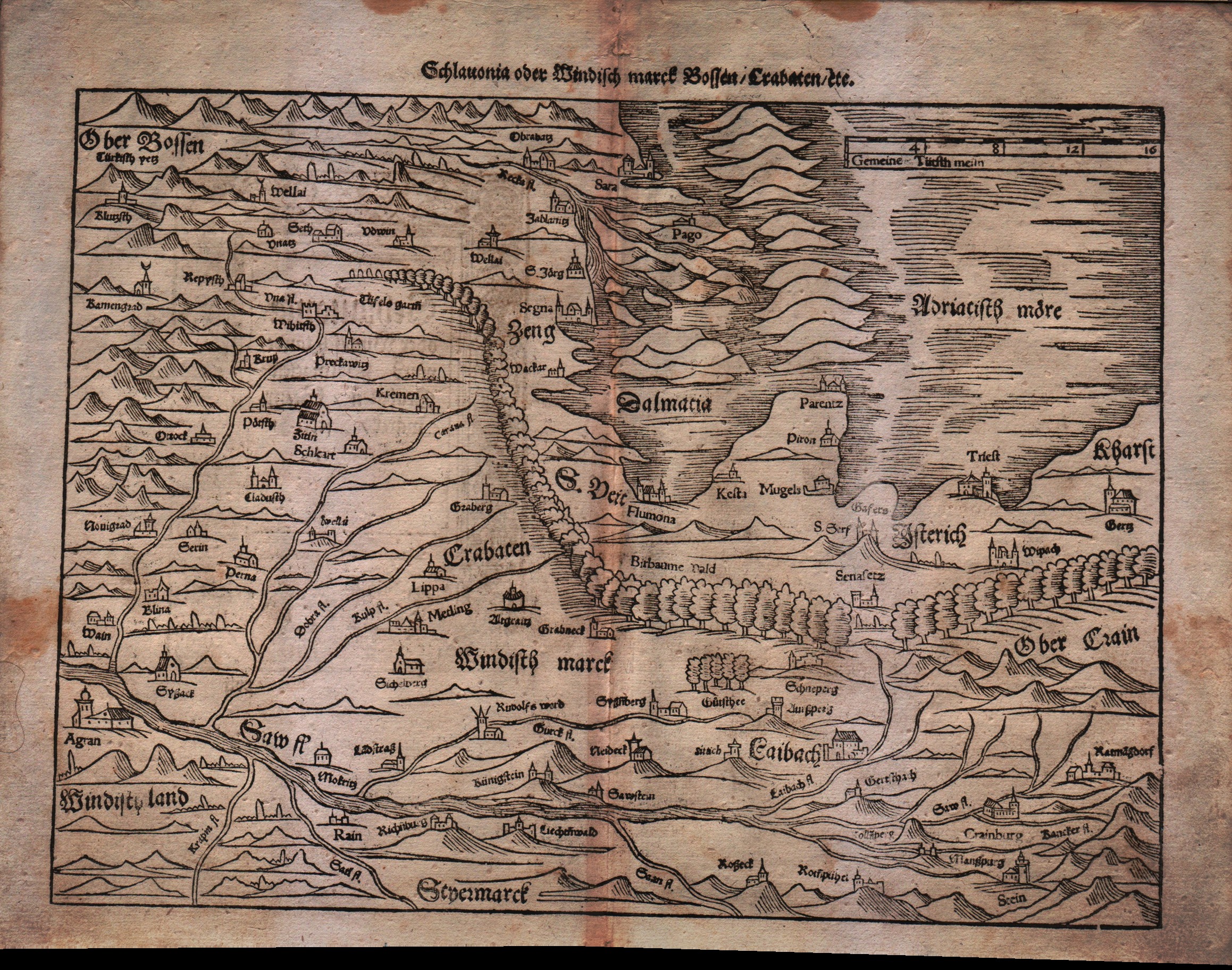
Map title
Sclavonia oder Windisch Marck Bossen Crabaten ...
Author
Munster
Location shown in map
Slovenia,Kroatia,Bosnia,Triest
Edition date
Unknown
Edition place
Basel
Editor
Henrich Petri
Atlas
Cosmographia Universalis
Price
200 Euro
State
[mint/EXCELLENT/very good/good/fair/mediocre/poor]
Color
Black/white
Verso
German text pag.???
Size
Plate: cm (34.3 x 25.4) inches (13.5 x 10) Paper: cm (40.6 x 31.8) inches (15.98 x 12.52)
Technique
Woodcut
Note
--
Reference
--
Wiki
Here for more info
In stock
Available
Info
info@thetreasuremaps.com
Code
#0113
×
![Sclavonia oder Windisch Marck Bossen Crabaten ... by Munster, Slovenia,Kroatia,Bosnia,Triest, Unknown]()
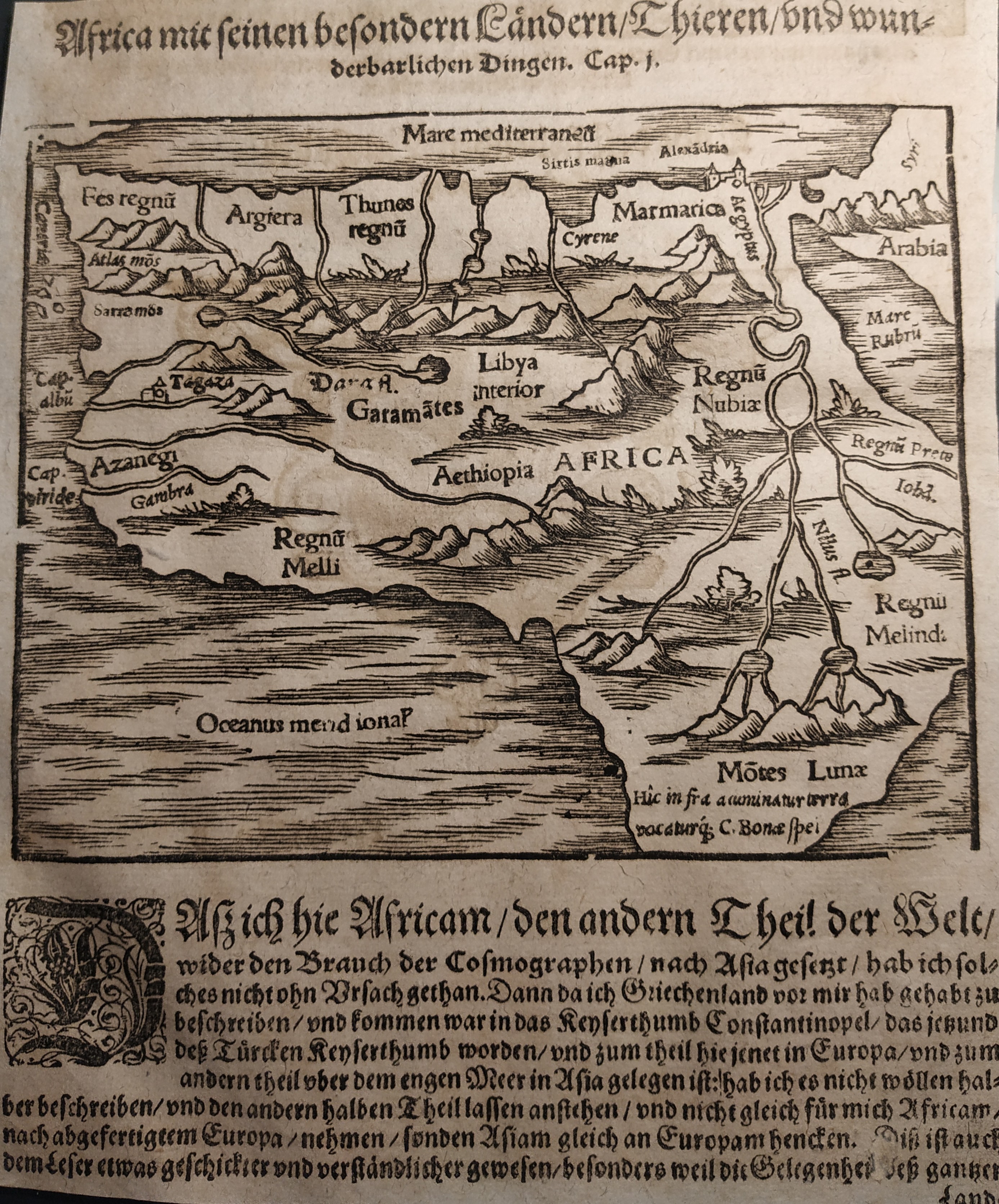
Map title
Africa
Author
Munster
Location shown in map
Africa
Edition date
Circa 1550
Edition place
Basel
Editor
Henrich Petri
Atlas
Cosmographia Universalis
Price
150 Euro
State
[mint/EXCELLENT/very good/good/fair/mediocre/poor]
Color
Black/white
Verso
German text
Size
Plate: cm (16 x 13) inches (6.3 x 5.12) Paper: cm (17 x 21) inches (6.69 x 8.27)
Technique
Woodcut
Note
No particular notes for this maps
Reference
Wiki
Here for more info
In stock
Available
Info
info@thetreasuremaps.com
Code
#0737
Africa
Author
Munster
Location shown in map
Africa
Edition date
Circa 1550
Edition place
Basel
Editor
Henrich Petri
Atlas
Cosmographia Universalis
Price
150 Euro
State
[mint/EXCELLENT/very good/good/fair/mediocre/poor]
Color
Black/white
Verso
German text
Size
Plate: cm (16 x 13) inches (6.3 x 5.12) Paper: cm (17 x 21) inches (6.69 x 8.27)
Technique
Woodcut
Note
No particular notes for this maps
Reference
Wiki
Here for more info
In stock
Available
Info
info@thetreasuremaps.com
Code
#0737
×
![Africa by Munster, Africa, Circa 1550]()
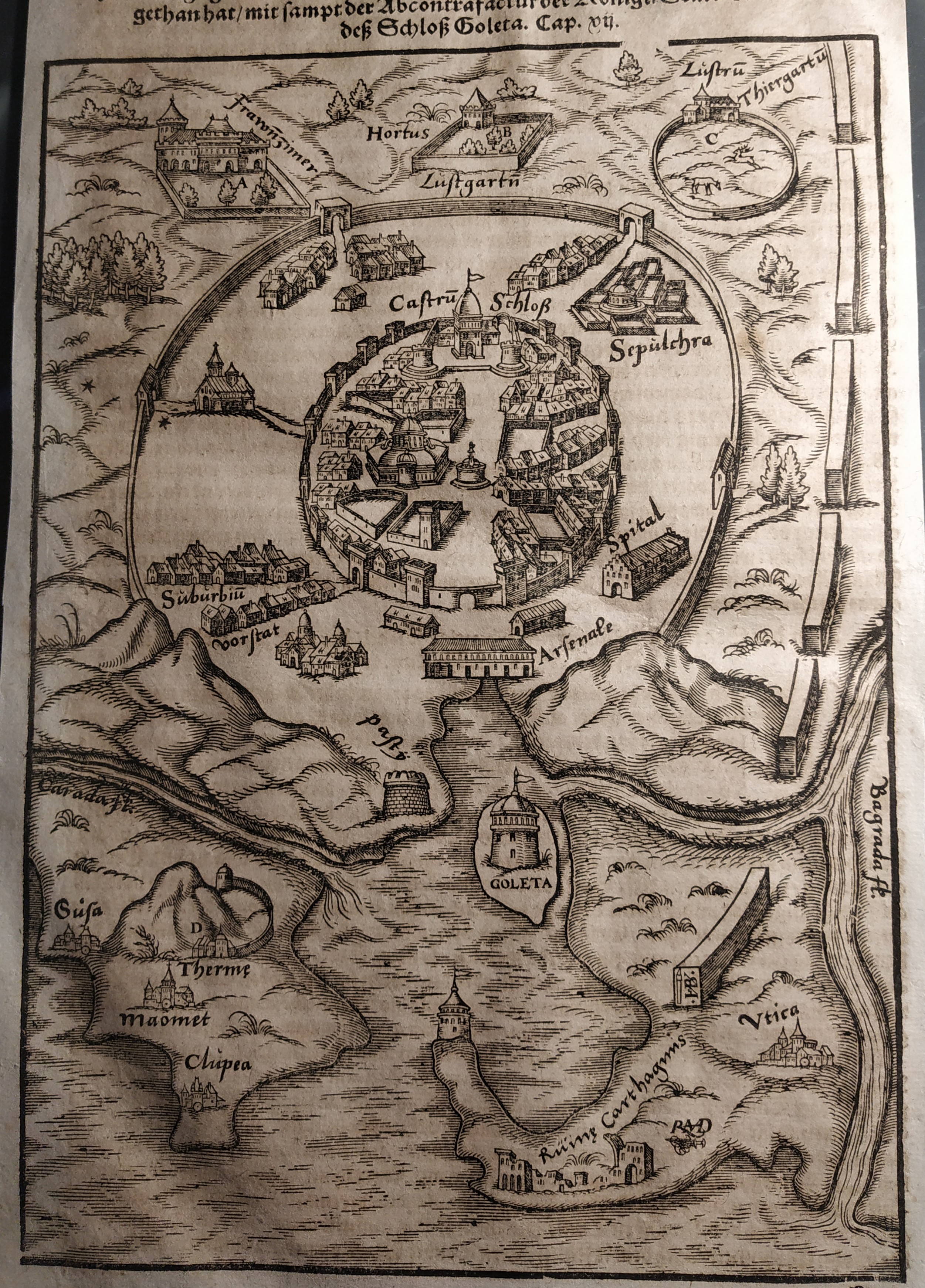
Map title
Goleta
Author
Munster
Location shown in map
Tunis
Edition date
Circa 1550
Edition place
Basel
Editor
Henrich Petri
Atlas
Cosmographia Universalis
Price
Please ask: info@thetreasuremaps.com
State
[mint/EXCELLENT/very good/good/fair/mediocre/poor]
Color
Black/white
Verso
German text
Size
Plate: cm (17 x 24) inches (6.69 x 9.45) Paper: cm (18 x 30) inches (7.09 x 11.81)
Technique
Woodcut
Note
No particular notes for this maps
Reference
Wiki
Here for more info
In stock
Available
Info
info@thetreasuremaps.com
Code
#0738
×
![Goleta by Munster, Tunis, Circa 1550]()
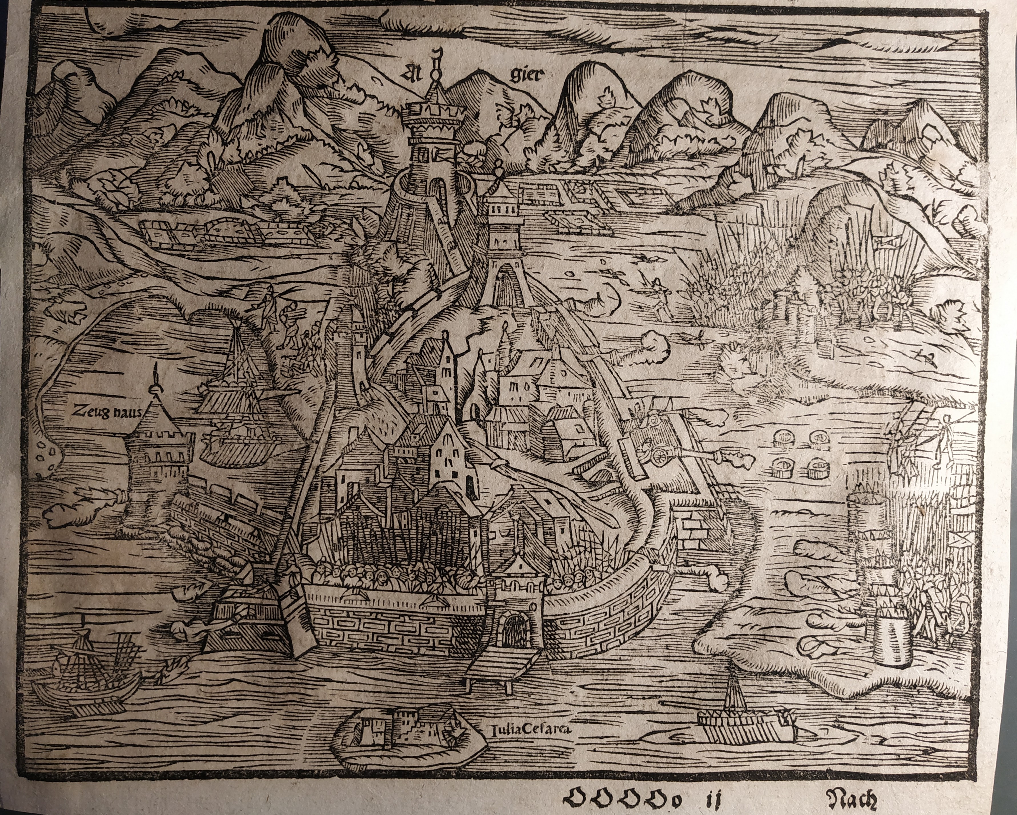
Map title
Algiers
Author
Munster
Location shown in map
Algiers
Edition date
Circa 1550
Edition place
Basel
Editor
Henrich Petri
Atlas
Cosmographia Universalis
Price
Please ask: info@thetreasuremaps.com
State
[mint/EXCELLENT/very good/good/fair/mediocre/poor]
Color
Black/white
Verso
German text
Size
Plate: cm (11 x 15) inches (4.33 x 5.91) Paper: cm (13 x 21) inches (5.12 x 8.27)
Technique
Woodcut
Note
No particular notes for this maps
Reference
Wiki
Here for more info
In stock
Available
Info
info@thetreasuremaps.com
Code
#0739
Algiers
Author
Munster
Location shown in map
Algiers
Edition date
Circa 1550
Edition place
Basel
Editor
Henrich Petri
Atlas
Cosmographia Universalis
Price
Please ask: info@thetreasuremaps.com
State
[mint/EXCELLENT/very good/good/fair/mediocre/poor]
Color
Black/white
Verso
German text
Size
Plate: cm (11 x 15) inches (4.33 x 5.91) Paper: cm (13 x 21) inches (5.12 x 8.27)
Technique
Woodcut
Note
No particular notes for this maps
Reference
Wiki
Here for more info
In stock
Available
Info
info@thetreasuremaps.com
Code
#0739
×
![Algiers by Munster, Algiers, Circa 1550]()
Map title
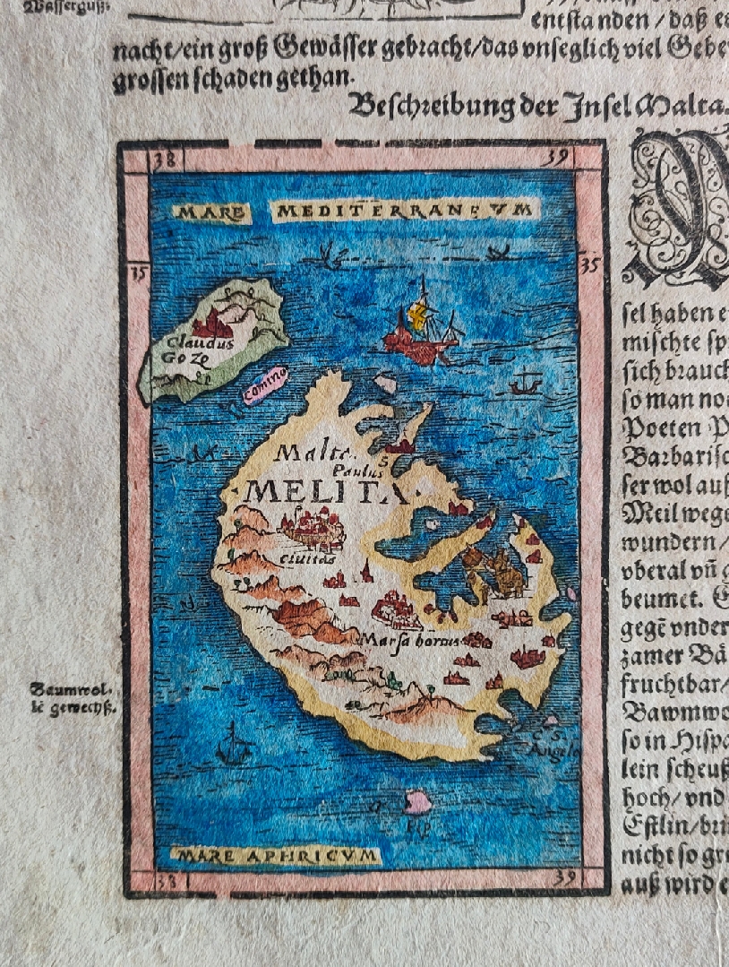
Malta
Author
Munster
Location shown in map
Malta
Edition date
Circa 1550
Edition place
Basel
Editor
Henrich Petri
Atlas
Cosmographia Universalis
Price
200 Euro
State
[mint/EXCELLENT/very good/good/fair/mediocre/poor]
Color
Old colors
Verso
German text pag.613
Size
Plate: cm (24 x 36) inches (9.45 x 14.17) Paper: cm (8 x 12) inches (3.15 x 4.72)
Technique
Woodcut
Note
Reference
Wiki
Here for more info
In stock
Available
Info
info@thetreasuremaps.com
Code
#0843
Malta
Author
Munster
Location shown in map
Malta
Edition date
Circa 1550
Edition place
Basel
Editor
Henrich Petri
Atlas
Cosmographia Universalis
Price
200 Euro
State
[mint/EXCELLENT/very good/good/fair/mediocre/poor]
Color
Old colors
Verso
German text pag.613
Size
Plate: cm (24 x 36) inches (9.45 x 14.17) Paper: cm (8 x 12) inches (3.15 x 4.72)
Technique
Woodcut
Note
Reference
Wiki
Here for more info
In stock
Available
Info
info@thetreasuremaps.com
Code
#0843
×
![Malta by Munster, Malta, Circa 1550]()
Map title
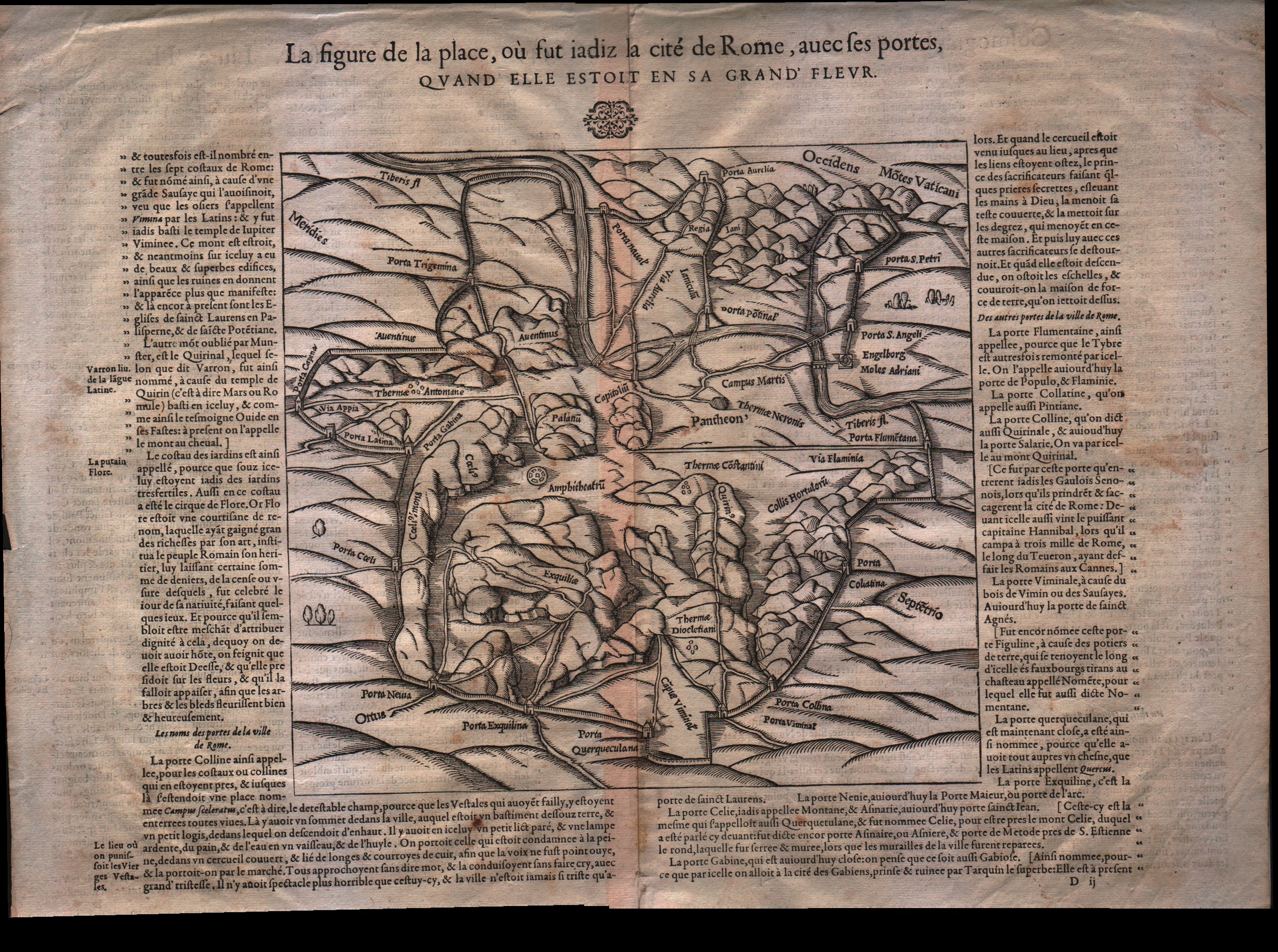
La figure de la place de Rome...
Author
Munster
Location shown in map
Rome
Edition date
1550
Edition place
Basel
Editor
Henrich Petri
Atlas
Cosmographia Universalis
Price
200 Euro
State
[mint/EXCELLENT/very good/good/fair/mediocre/poor]
Color
Black/white
Verso
French text pag.550
Size
Plate: cm (22.9 x 21.6) inches (9.02 x 8.5) Paper: cm (41.9 x 34.3) inches (16.5 x 13.5)
Technique
Woodcut
Note
No particular notes for this maps
Reference
--
Wiki
Here for more info
In stock
Available
Info
info@thetreasuremaps.com
Code
#0095
×
![La figure de la place de Rome... by Munster, Rome, 1550]()
Map title
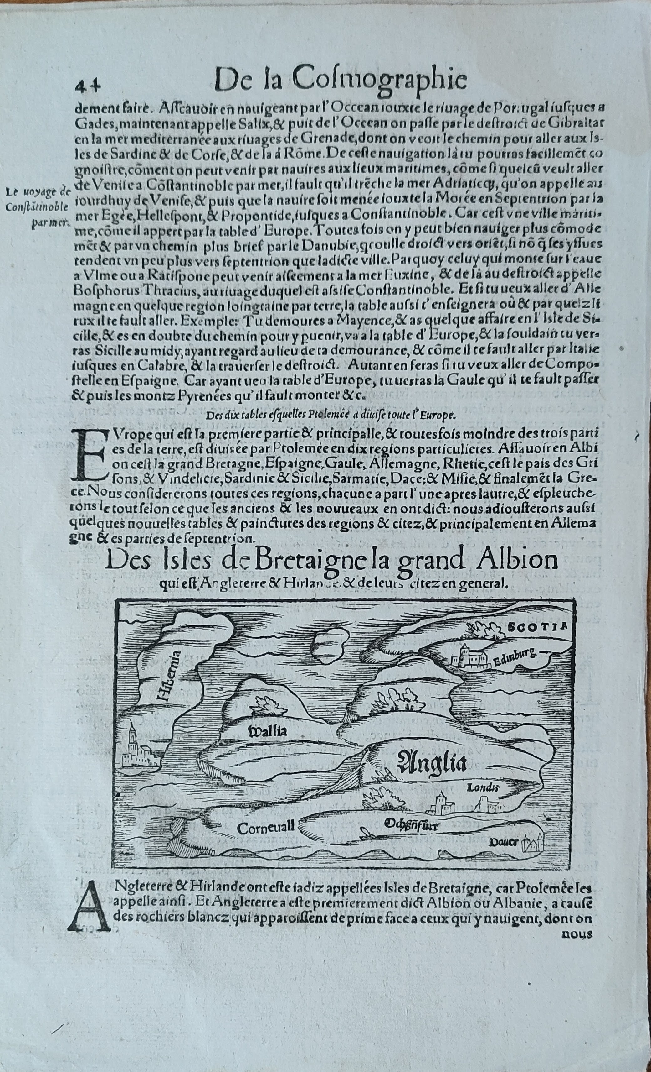
Des isles de Bretaigne la gran Albion
Author
Munster
Location shown in map
England
Edition date
Circa 1552
Edition place
Basel
Editor
Henrich Petri
Atlas
Cosmographia Universalis
Price
150 Euro
State
[mint/EXCELLENT/very good/good/fair/mediocre/poor]
Color
Black/white
Verso
French text pag.43
Size
Plate: cm (13 x 8) inches (5.12 x 3.15) Paper: cm (20 x 31) inches (7.87 x 12.2)
Technique
Woodcut
Note
Reference
Wiki
Here for more info
In stock
Available
Info
info@thetreasuremaps.com
Code
#0954
×
![Des isles de Bretaigne la gran Albion by Munster, England, Circa 1552]()
Map title
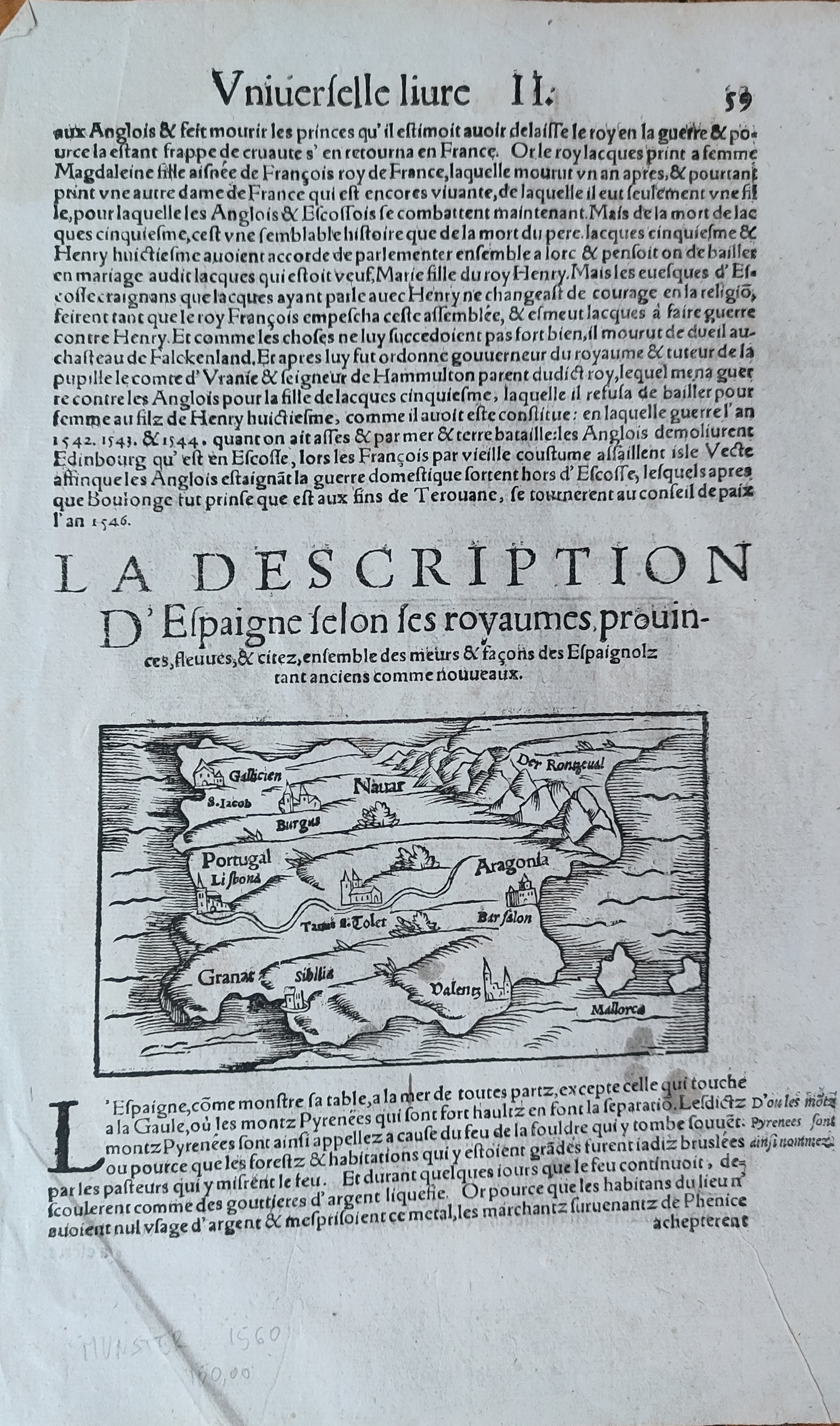
Espaigne
Author
Munster
Location shown in map
Spain
Edition date
Circa 1552
Edition place
Basel
Editor
Henrich Petri
Atlas
Cosmographia Universalis
Price
125 Euro
State
[mint/EXCELLENT/very good/good/fair/mediocre/poor]
Color
Black/white
Verso
French text pag.60
Size
Plate: cm (13 x 8) inches (5.12 x 3.15) Paper: cm (20 x 31) inches (7.87 x 12.2)
Technique
Woodcut
Note
Reference
Wiki
Here for more info
In stock
Available
Info
info@thetreasuremaps.com
Code
#0955
×
![Espaigne by Munster, Spain, Circa 1552]()
Map title
--
Author
Munster
Location shown in map
Italy
Edition date
Circa 1552
Edition place
Basel
Editor
Henrich Petri
Atlas
Cosmographia Universalis
Price
250 Euro
State
[mint/EXCELLENT/very good/good/fair/mediocre/poor]
Color
Black/white
Verso
French text pag.142
Size
Plate: cm (13 x 8) inches (5.12 x 3.15) Paper: cm (21 x 31) inches (8.27 x 12.2)
Technique
Woodcut
Note
Reference
R.Borri L'Italia nelle antiche carte pag.40
Wiki
Here for more info
In stock
Available
Info
info@thetreasuremaps.com
Code
#0630
×
![-- by Munster, Italy, Circa 1552]()
Map title
Description de la Germanie
Author
Munster
Location shown in map
Germany
Edition date
1552
Edition place
Basel
Editor
Henrich Petri
Atlas
Cosmographia Universalis
Price
300 Euro
State
[mint/EXCELLENT/very good/good/fair/mediocre/poor]
Color
Black/white
Verso
Franch text pag.6
Size
Plate: cm (34 x 25) inches (13.39 x 9.84) Paper: cm (39 x 30) inches (15.35 x 11.81)
Technique
Woodcut
Note
No particular notes for this maps.
Reference
--
Wiki
Here for more info
In stock
Available
Info
info@thetreasuremaps.com
Code
#0722
×
![Description de la Germanie by Munster, Germany, 1552]()
Map title
--
Author
Munster
Location shown in map
Italy
Edition date
Circa 1552
Edition place
Basel
Editor
Henrich Petri
Atlas
Cosmographia Universalis
Price
250 Euro
State
[mint/EXCELLENT/very good/good/fair/mediocre/poor]
Color
Black/white
Verso
German text pag.105
Size
Plate: cm (13 x 16) inches (5.12 x 6.3) Paper: cm (21 x 31) inches (8.27 x 12.2)
Technique
Woodcut
Note
Reference
Wiki
Here for more info
In stock
Available
Info
info@thetreasuremaps.com
Code
#1101
×
![-- by Munster, Italy, Circa 1552]()
Pages: 1 2