Robert de Vaugondy
Map title
Carte de l'Etat de Genes, ou se trouvent les environs de Savone partie du Marquisat de Finale du Piemont.
Author
Robert de Vaugondy
Location shown in map
Liguria
Edition date
1748
Edition place
Paris
Editor
Durand & Pissot
Atlas
Atlas portatif universel et militaire
Price
150 Euro
State
[MINT/excellent/very good/good/fair/mediocre/poor]
Color
Old colors
Verso
Blank
Size
Plate: cm (20.3 x 15.2) inches (7.99 x 5.98) Paper: cm (24.1 x 19) inches (9.49 x 7.48)
Technique
Copper engraving
Note
No particular notes for this maps.
Reference
--
Wiki
Here for more info
In stock
Available
Info
info@thetreasuremaps.com
Code
#0554
×
![]()
Map title
L'Italie et ses isles ...
Author
Robert de Vaugondy
Location shown in map
Italy
Edition date
1748
Edition place
Paris
Editor
--
Atlas
Atlas Portatif Universel et Militaire
Price
100 Euro
State
[mint/EXCELLENT/very good/good/fair/mediocre/poor]
Color
Modern color
Verso
Blank
Size
Plate: cm (16 x 16) inches (6.3 x 6.3) Paper: cm (28 x 22) inches (11.02 x 8.66)
Technique
Copper engraving
Note
Reference
--
Wiki
Here for more info
In stock
Available
Info
info@thetreasuremaps.com
Code
#0901
×
![]()
Map title
Amerique Meridionale
Author
Robert de Vaugondy
Location shown in map
South America
Edition date
1748
Edition place
Paris
Editor
--
Atlas
Atlas Portatif Universel et Militaire
Price
50 Euro
State
[mint/EXCELLENT/very good/good/fair/mediocre/poor]
Color
Old colors
Verso
Blank
Size
Plate: cm (20 x 16) inches (7.87 x 6.3) Paper: cm (23 x 18) inches (9.06 x 7.09)
Technique
Copper engraving
Note
Reference
--
Wiki
Here for more info
In stock
Available
Info
info@thetreasuremaps.com
Code
#1004
×
![]()
Map title
Le royaume d'Angleterre
Author
Robert de Vaugondy
Location shown in map
British Isles
Edition date
1753
Edition place
Paris
Editor
Delamarche
Atlas
Atlas Universel
Price
200 Euro
State
[mint/excellent/VERY GOOD/good/fair/mediocre/poor]
Color
Old color
Verso
Blank
Size
Plate: cm (66 x 51) inches (25.98 x 20.08) Paper: cm (53 x 49) inches (20.87 x 19.29)
Technique
Copper engraving
Note
No particular notes for this maps.
Reference
--
Wiki
Here for more info
In stock
Available
Info
info@thetreasuremaps.com
Code
#0759
×
![]()
Map title
Les Isles Britanniques qui comprennent les Royaumes d'Angleterre, d'Ecosse et d'Irlande.
Author
Robert de Vaugondy
Location shown in map
British Isles
Edition date
1754
Edition place
Paris
Editor
Atlas
Atlas Universel
Price
200 Euro
State
[mint/EXCELLENT/very good/good/fair/mediocre/poor]
Color
Old colors
Verso
Blank
Size
Plate: cm (58 x 48) inches (22.83 x 18.9) Paper: cm (73 x 55) inches (28.74 x 21.65)
Technique
Copper engraving
Note
Reference
Wiki
Here for more info
In stock
Available
Info
info@thetreasuremaps.com
Code
#1072
×
![]()
Map title
L'Italie
Author
Robert de Vaugondy
Location shown in map
Italy
Edition date
Circa 1760
Edition place
Paris
Editor
Boudet
Atlas
Atlas Universel
Price
300 Euro
State
[mint/EXCELLENT/very good/good/fair/mediocre/poor]
Color
Old color
Verso
Blank
Size
Plate: cm (55 x 48) inches (21.65 x 18.9) Paper: cm (65 x 54) inches (25.59 x 21.26)
Technique
Copper engraving
Note
Reference
Wiki
Here for more info
In stock
Available
Info
info@thetreasuremaps.com
Code
#0787
×
![]()
Map title
Canada, Louisiane, Possessions Anglais
Author
Robert de Vaugondy
Location shown in map
North America
Edition date
1762
Edition place
Paris
Editor
--
Atlas
Atlas Protatif
Price
300 Euro
State
[mint/EXCELLENT/very good/good/fair/mediocre/poor]
Color
Black/white
Verso
Blank
Size
Plate: cm (29.2 x 24.1) inches (11.5 x 9.49) Paper: cm (40.6 x 26.7) inches (15.98 x 10.51)
Technique
Copper engraving
Note
First state of this interesting map of the colonial possessions of England, France and Spain in North America. A large inset map covers the west coast and is most notable for its depiction of two remarkable cartographic misconceptions; a huge Mer de l' Ouest or Sea of the West and a Northwest Passage through a system of rivers and lakes connecting Hudson Bay with the Pacific based on the fictitious discoveries of Admiral de Font.
Reference
--
Wiki
Here for more info
In stock
Available
Info
info@thetreasuremaps.com
Code
#0058
×
![]()

Map title
La France divisee suivant ses Provinces ou Gouvernements Militaire. Par le S.r Robert Vaugondy Geographe
Author
Robert de Vaugondy
Location shown in map
France
Edition date
1771
Edition place
Paris
Editor
Delamarche
Atlas
Atlas moderne. Seconde partie.
Price
Please ask: info@thetreasuremaps.com
State
[mint/excellent/VERY GOOD/good/fair/mediocre/poor]
Color
Old outlined
Verso
Blank
Size
Plate: cm (71 x 50) inches (27.95 x 19.69) Paper: cm (74 x 51) inches (29.13 x 20.08)
Technique
Copper engraving
Note
Reference
Wiki
Here for more info
In stock
Available
Info
info@thetreasuremaps.com
Code
#0772
×
![]()
Map title
Le Royaume de Pologne
Author
Robert de Vaugondy
Location shown in map
Poland
Edition date
Circa 1776
Edition place
Venice
Editor
Santini
Atlas
Atlas Universel
Price
250 Euro
State
[mint/EXCELLENT/very good/good/fair/mediocre/poor]
Color
Old colors
Verso
Blank
Size
Plate: cm (61 x 48) inches (24.02 x 18.9) Paper: cm (72 x 53) inches (28.35 x 20.87)
Technique
Copper engraving
Note
Reference
Wiki
Here for more info
In stock
Available
Info
info@thetreasuremaps.com
Code
#1070
×
![]()
Map title
Italia antiqua
Author
Robert de Vaugondy
Location shown in map
Italy
Edition date
1778
Edition place
Venice
Editor
Santini
Atlas
Atlas Universel
Price
250 Euro
State
[mint/excellent/VERY GOOD/good/fair/mediocre/poor]
Color
Old colors
Verso
Blank
Size
Plate: cm (54 x 47) inches (21.26 x 18.5) Paper: cm (67 x 51) inches (26.38 x 20.08)
Technique
Copper engraving
Note
Reference
R.Borri L'Italia nelle antiche carte pag.249
Wiki
Here for more info
In stock
Available
Info
info@thetreasuremaps.com
Code
#1058
×
![]()
Map title
Cartes des isles Britanniques
Author
Robert de Vaugondy
Location shown in map
British Isles
Edition date
Circa 1780
Edition place
Paris
Editor
Delamarche
Atlas
Atlas d Etude pour l'instruction de la Jeunesse
Price
Please ask: info@thetreasuremaps.com
State
[mint/excellent/VERY GOOD/good/fair/mediocre/poor]
Color
Old color
Verso
Blank
Size
Plate: cm (71 x 53) inches (27.95 x 20.87) Paper: cm (77 x 57) inches (30.31 x 22.44)
Technique
Copper engraving
Note
Professionally rapaired
Reference
--
Wiki
Here for more info
In stock
Available
Info
info@thetreasuremaps.com
Code
#0744
×
![]()
Map title
Mappe Monde ou Carte Generale du Globe Terrestre
Author
Robert de Vaugondy
Location shown in map
World
Edition date
1786
Edition place
Paris
Editor
Delamarche
Atlas
Price
3000 Euro
State
[mint/EXCELLENT/very good/good/fair/mediocre/poor]
Color
Old colors
Verso
Blank
Size
Plate: cm (0 x 0) inches (0 x 0) Paper: cm (119 x 101) inches (46.85 x 39.76)
Technique
Copper engraving
Note
Framed, foldable map
Reference
Wiki
Here for more info
In stock
Available
Info
info@thetreasuremaps.com
Code
#1089
×
![]()
Map title
L'Amerique
Author
Robert de Vaugondy
Location shown in map
Americas
Edition date
1795
Edition place
Paris
Editor
Delamarche
Atlas
Atlas Portatif de Vaugondy
Price
100 Euro
State
[MINT/excellent/very good/good/fair/mediocre/poor]
Color
Old color
Verso
Blank
Size
Plate: cm (22 x 24) inches (8.66 x 9.45) Paper: cm (37 x 30) inches (14.57 x 11.81)
Technique
Copper engraving
Note
Reference
--
Wiki
Here for more info
In stock
Available
Info
info@thetreasuremaps.com
Code
#0752
×
![]()
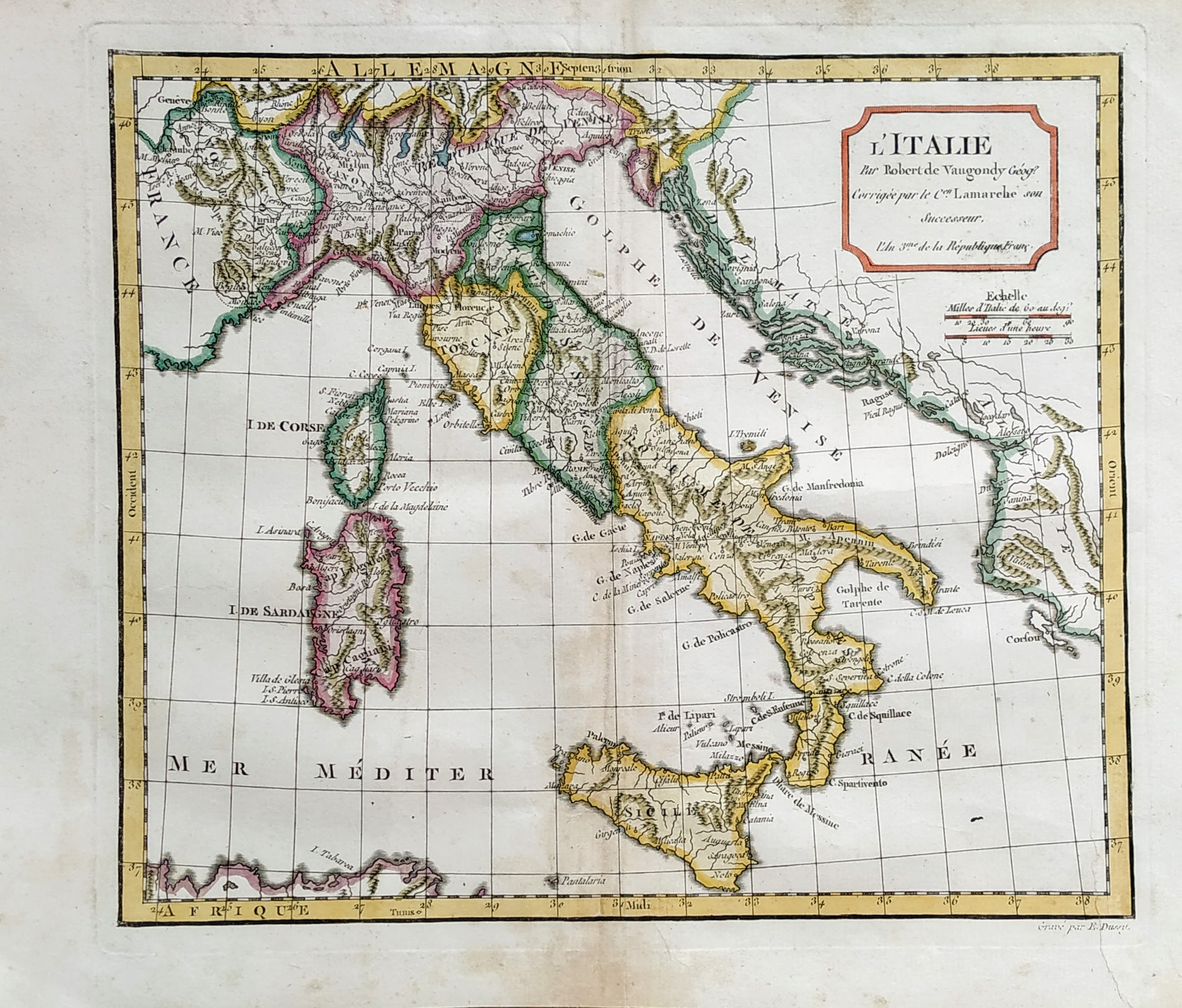
Map title
L'Italie
Author
Robert de Vaugondy
Location shown in map
Italy
Edition date
1795
Edition place
Paris
Editor
Atlas
Atlas portatif universel et militaire
Price
125 Euro
State
[mint/EXCELLENT/very good/good/fair/mediocre/poor]
Color
Old colors
Verso
Blank
Size
Plate: cm (37 x 26) inches (14.57 x 10.24) Paper: cm (44 x 32) inches (17.32 x 12.6)
Technique
Copper engraving
Note
Reference
--
Wiki
Here for more info
In stock
Available
Info
info@thetreasuremaps.com
Code
#0821
×
![]()