1600-1699
Map title
Pedemontanae vicinorumque
Author
Ortelius
Location shown in map
Liguria
Edition date
Circa 1601
Edition place
Antwerp
Editor
--
Atlas
Epitome Theatri Orteliani
Price
175 Euro
State
[mint/EXCELLENT/very good/good/fair/mediocre/poor]
Color
Black/white
Verso
French text
Size
Plate: cm (11 x 8) inches (4.33 x 3.15) Paper: cm (15.5 x 11) inches (6.1 x 4.33)
Technique
Copper engraving
Note
Reference
L.Tricerri, Catalog of Maps of Liguria R_020
Wiki
Here for more info
In stock
Available
Info
info@thetreasuremaps.com
Code
#1292
×
![Pedemontanae vicinorumque by Ortelius, Liguria, Circa 1601]()
Map title
Hiberniae Britannicae insulae nova descriptio
Author
Ortelius
Location shown in map
Ireland
Edition date
1601
Edition place
Antwerp
Editor
--
Atlas
Theatrum Orbis Terrarum
Price
900 Euro
State
[mint/EXCELLENT/very good/good/fair/mediocre/poor]
Color
Old colors
Verso
Latin text pag.14
Size
Plate: cm (48 x 35) inches (18.9 x 13.78) Paper: cm (55 x 43) inches (21.65 x 16.93)
Technique
Copper engraving
Note
Reference
Van Den Broecke 63
Wiki
Here for more info
In stock
Sold
Info
info@thetreasuremaps.com
Code
#1019
×
![Hiberniae Britannicae insulae nova descriptio by Ortelius, Ireland, 1601]()
Map title
Descrittione dell'isola di Corsica
Author
Porcacchi
Location shown in map
Corse
Edition date
1602
Edition place
Venice
Editor
--
Atlas
L'Isole piu famose del mondo -- S. Galignani and G. Porro
Price
250 Euro
State
[mint/EXCELLENT/very good/good/fair/mediocre/poor]
Color
Black/white
Verso
Italian text pag.42
Size
Plate: cm (15.2 x 11.4) inches (5.98 x 4.49) Paper: cm (21 x 30) inches (8.27 x 11.81)
Technique
Copper engraving
Note
Reference
--
Wiki
Here for more info
In stock
Available
Info
info@thetreasuremaps.com
Code
#0972
×
![Descrittione dell'isola di Corsica by Porcacchi, Corse, 1602]()
Map title
Hibernia
Author
Ortelius
Location shown in map
Ireland
Edition date
1602
Edition place
Antwerp
Editor
Jean-Baptiste Uriens
Atlas
Abrege du Theatre d'Ortelius
Price
175 Euro
State
[mint/EXCELLENT/very good/good/fair/mediocre/poor]
Color
Old colors
Verso
French text
Size
Plate: cm (11 x 8) inches (4.33 x 3.15) Paper: cm (11 x 8) inches (4.33 x 3.15)
Technique
Copper engraving
Note
Plate 2 map
Reference
Wiki
Here for more info
In stock
Available
Info
info@thetreasuremaps.com
Code
#1079
×
![Hibernia by Ortelius, Ireland, 1602]()
Map title
Descrittione dell'arcipelago
Author
Porcacchi
Location shown in map
Greece
Edition date
1602
Edition place
Venice
Editor
--
Atlas
L'Isole piu famose del mondo -- S. Galignani and G. Porro
Price
200 Euro
State
[MINT/excellent/very good/good/fair/mediocre/poor]
Color
Black/white
Verso
Italian text pag.74
Size
Plate: cm (15.2 x 11.4) inches (5.98 x 4.49) Paper: cm (19 x 29.2) inches (7.48 x 11.5)
Technique
Copper engraving
Note
No particular notes for this maps
Reference
--
Wiki
Here for more info
In stock
Available
Info
info@thetreasuremaps.com
Code
#0106
×
![Descrittione dell'arcipelago by Porcacchi, Greece, 1602]()
Map title
Caletensium et Bononiensium Ditionis Accurata Delineatio
Author
Ortelius
Location shown in map
--
Edition date
1602
Edition place
Anvers
Editor
--
Atlas
Theatrum Orbis Terrarum
Price
150 Euro
State
[mint/EXCELLENT/very good/good/fair/mediocre/poor]
Color
Modern color
Verso
French text
Size
Plate: cm (33 x 24.1) inches (12.99 x 9.49) Paper: cm (33 x 24.1) inches (12.99 x 9.49)
Technique
Copper engraving
Note
No particular notes for this maps
Reference
Van Den Broecke 44
Wiki
Here for more info
In stock
Available
Info
info@thetreasuremaps.com
Code
#0122
×
![Caletensium et Bononiensium Ditionis Accurata Delineatio by Ortelius, --, 1602]()
Map title
Italie Novissima Descriptio
Author
Ortelius
Location shown in map
Italy
Edition date
1603
Edition place
Antwerp
Editor
--
Atlas
Theatrum Orbis Terrarum
Price
700 Euro
State
[mint/EXCELLENT/very good/good/fair/mediocre/poor]
Color
Modern color
Verso
Latin text pag.74
Size
Plate: cm (50 x 35) inches (19.69 x 13.78) Paper: cm (56 x 46) inches (22.05 x 18.11)
Technique
Copper engraving
Note
Reference
Van Den Broecke 118
Wiki
Here for more info
In stock
Available
Info
info@thetreasuremaps.com
Code
#0802
×
![Italie Novissima Descriptio by Ortelius, Italy, 1603]()
Map title
Groot ende cleyn Iava
Author
Bertius
Location shown in map
Java
Edition date
Circa 1606
Edition place
Amsterdam
Editor
Atlas
Price
300 Euro
State
[mint/EXCELLENT/very good/good/fair/mediocre/poor]
Color
Black/white
Verso
Duch text pag.612
Size
Plate: cm (12 x 9) inches (4.72 x 3.54) Paper: cm (18 x 11) inches (7.09 x 4.33)
Technique
Copper engraving
Note
Reference
Wiki
Here for more info
In stock
Available
Info
info@thetreasuremaps.com
Code
#1251
×
![Groot ende cleyn Iava by Bertius, Java, Circa 1606]()
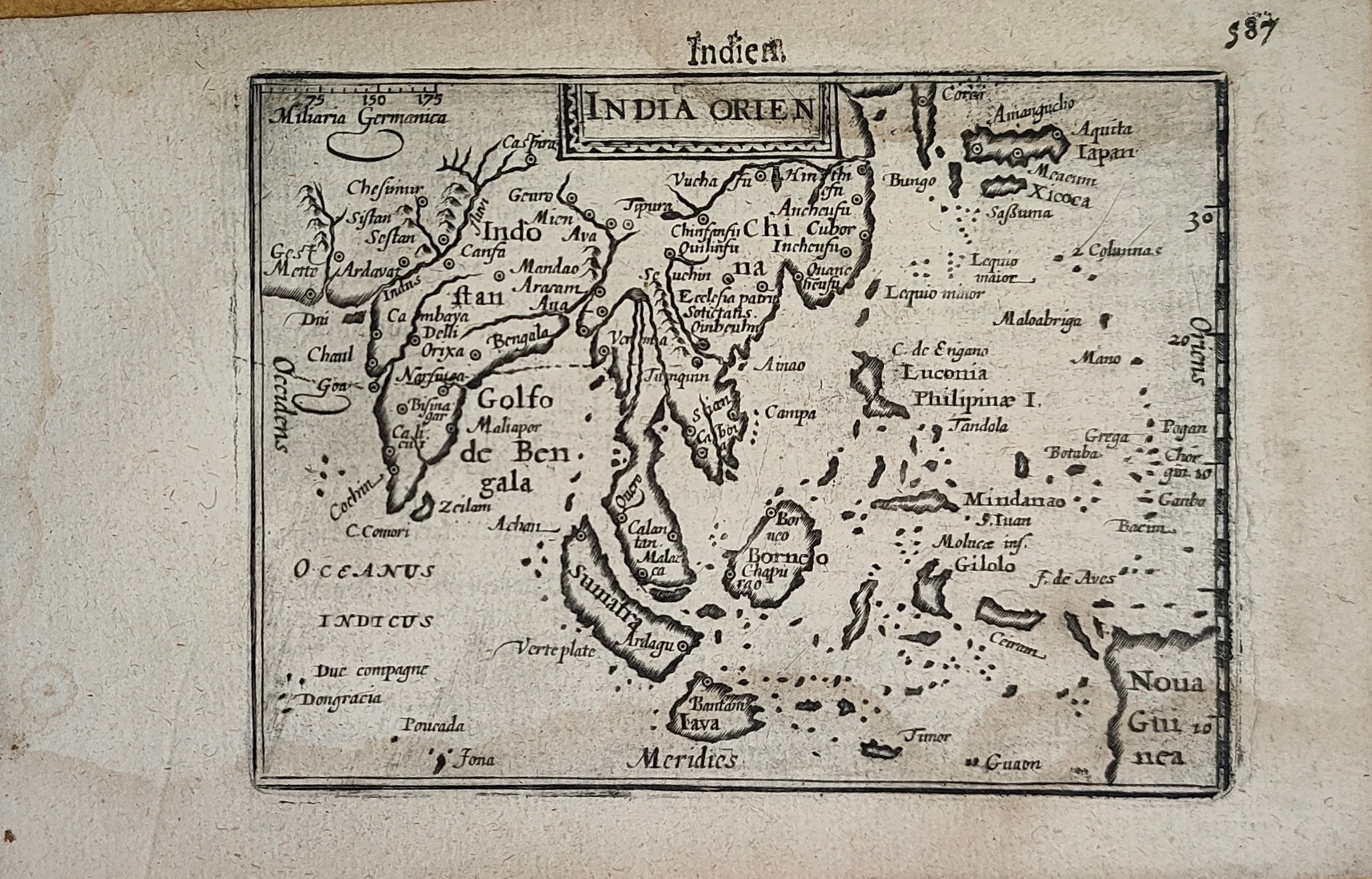
Map title
Indien
Author
Bertius
Location shown in map
South East
Edition date
Circa 1606
Edition place
Amsterdam
Editor
Atlas
Price
400 Euro
State
[mint/EXCELLENT/very good/good/fair/mediocre/poor]
Color
Black/white
Verso
Duch text pag.588
Size
Plate: cm (12 x 9) inches (4.72 x 3.54) Paper: cm (18 x 11) inches (7.09 x 4.33)
Technique
Copper engraving
Note
Reference
Wiki
Here for more info
In stock
Available
Info
info@thetreasuremaps.com
Code
#1252
×
![Indien by Bertius, South East, Circa 1606]()
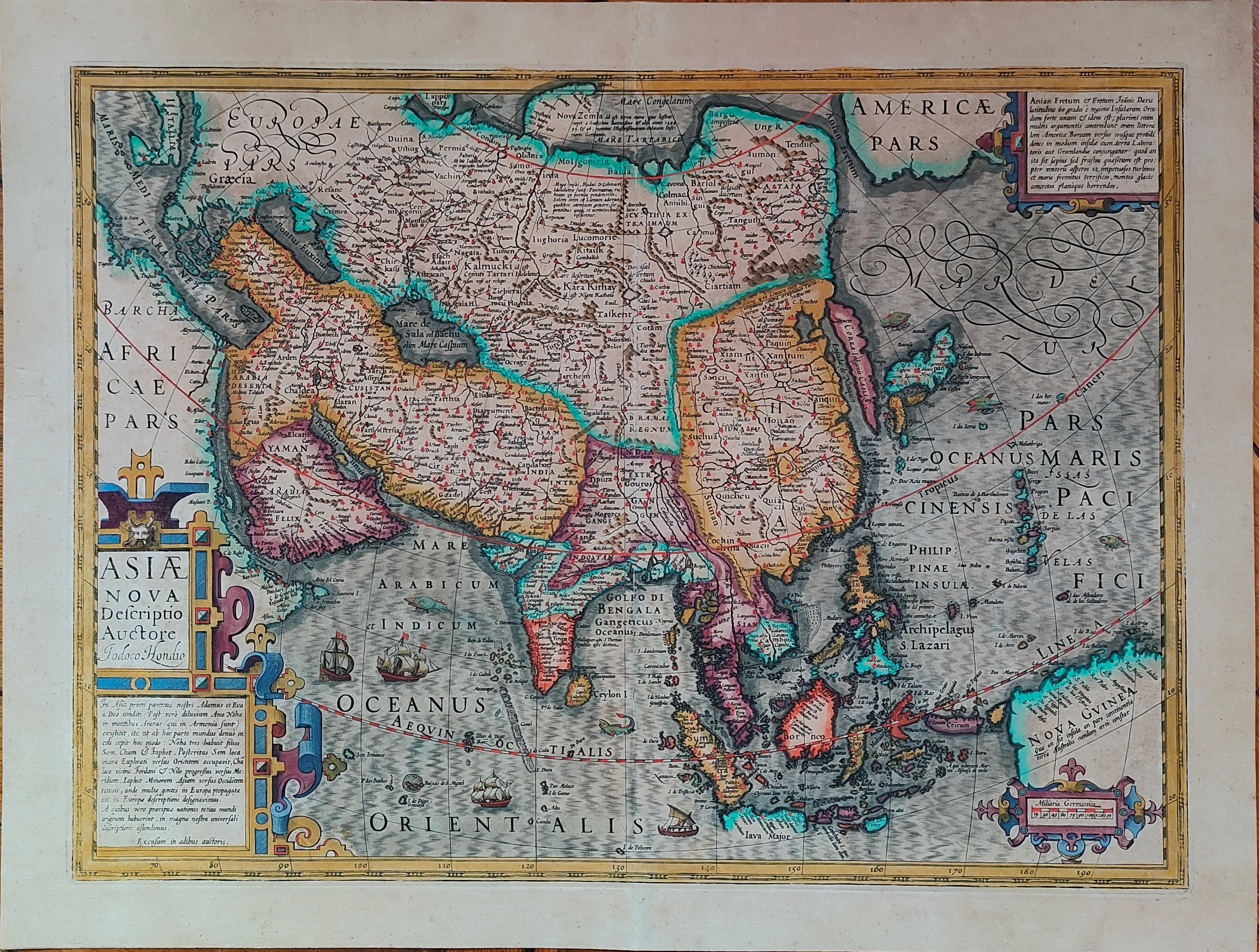
Map title
Asiae nova descriptio
Author
Hondius
Location shown in map
Asia
Edition date
Circa 1606
Edition place
Amsterdam
Editor
Hondius
Atlas
Price
1000 Euro
State
[mint/EXCELLENT/very good/good/fair/mediocre/poor]
Color
Old colors
Verso
Size
Plate: cm (50 x 37) inches (19.69 x 14.57) Paper: cm (57 x 47) inches (22.44 x 18.5)
Technique
Copper engraving
Note
Reference
Wiki
Here for more info
In stock
Available
Info
info@thetreasuremaps.com
Code
#1193
×
![Asiae nova descriptio by Hondius, Asia, Circa 1606]()
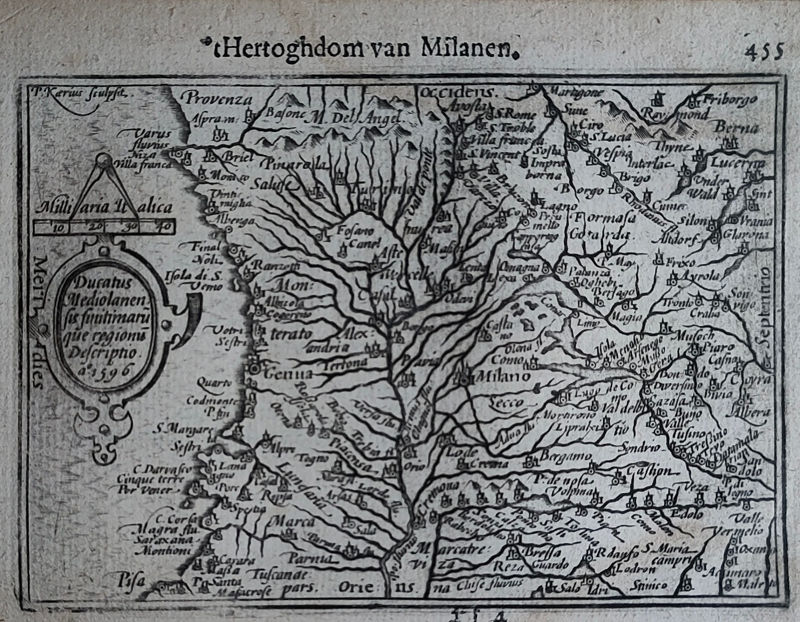
Map title
Hertoghdom van Milanen
Author
Bertius
Location shown in map
Liguria
Edition date
Circa 1606
Edition place
Amsterdam
Editor
Atlas
Price
200 Euro
State
[mint/EXCELLENT/very good/good/fair/mediocre/poor]
Color
Black/white
Verso
Duch text pag.456
Size
Plate: cm (12 x 9) inches (4.72 x 3.54) Paper: cm (18 x 11) inches (7.09 x 4.33)
Technique
Copper engraving
Note
Reference
Wiki
Here for more info
In stock
Available
Info
info@thetreasuremaps.com
Code
#1246
×
![Hertoghdom van Milanen by Bertius, Liguria, Circa 1606]()
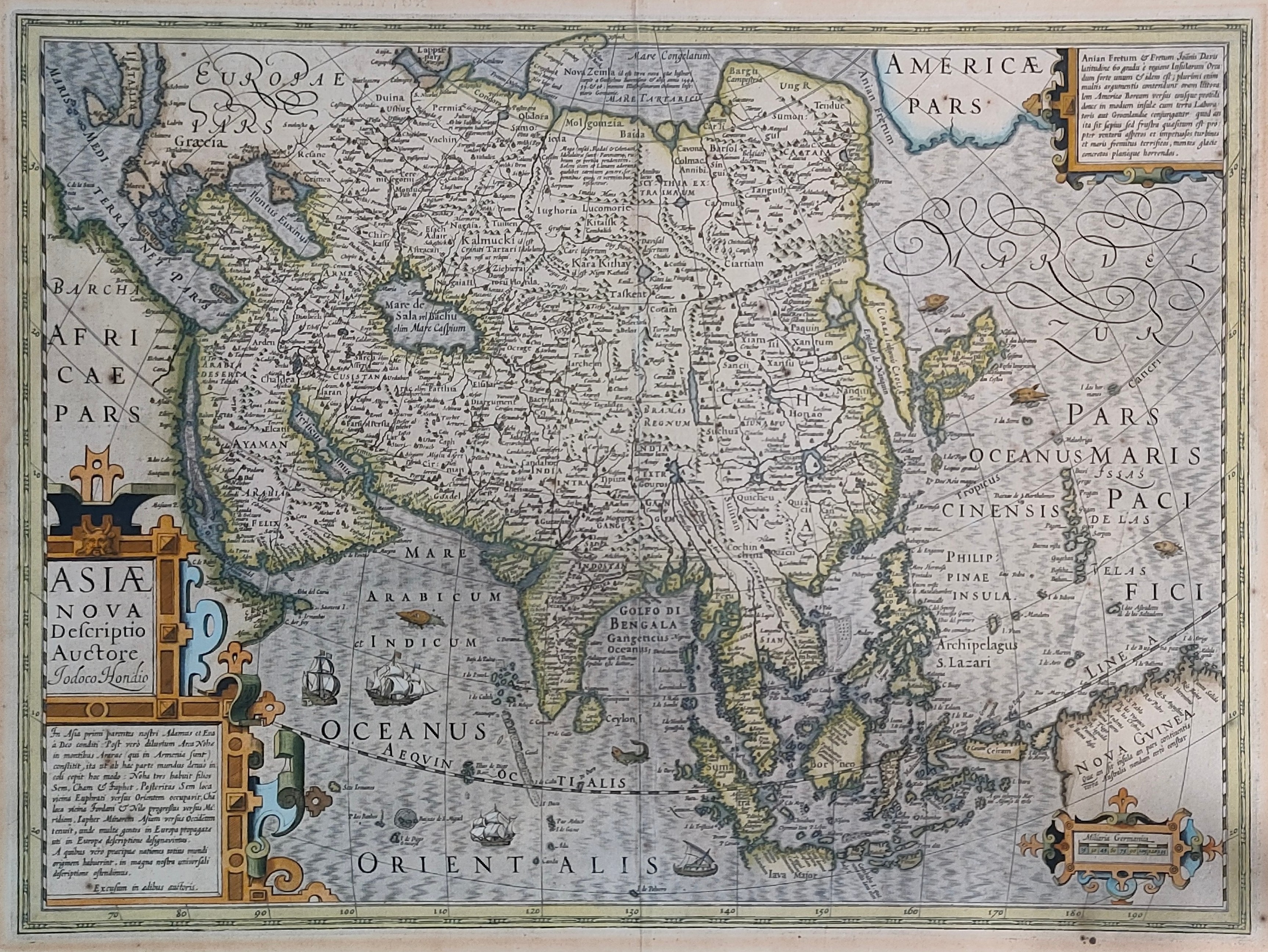
Map title
Asiae nova descriptio
Author
Hondius
Location shown in map
Asia
Edition date
Circa 1606
Edition place
Amsterdam
Editor
Hondius
Atlas
Price
1000 Euro
State
[mint/EXCELLENT/very good/good/fair/mediocre/poor]
Color
Old colors
Verso
Size
Plate: cm (50 x 37) inches (19.69 x 14.57) Paper: cm (57 x 47) inches (22.44 x 18.5)
Technique
Copper engraving
Note
Reference
Wiki
Here for more info
In stock
Available
Info
info@thetreasuremaps.com
Code
#0913
×
![Asiae nova descriptio by Hondius, Asia, Circa 1606]()
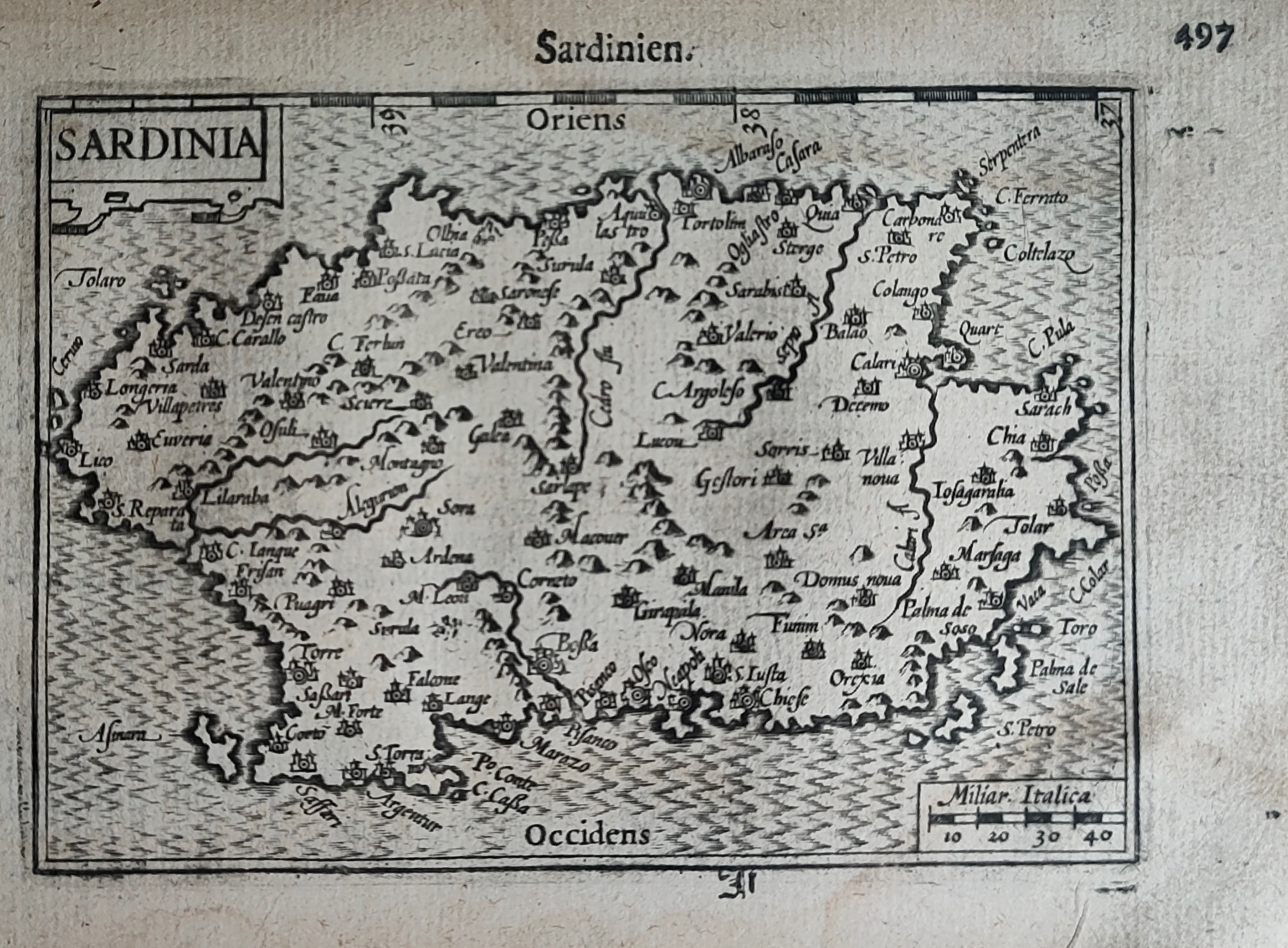
Map title
Sardinien
Author
Bertius
Location shown in map
Sardinia
Edition date
Circa 1606
Edition place
Amsterdam
Editor
Atlas
Price
250 Euro
State
[mint/EXCELLENT/very good/good/fair/mediocre/poor]
Color
Black/white
Verso
Duch text pag.498
Size
Plate: cm (12 x 9) inches (4.72 x 3.54) Paper: cm (18 x 11) inches (7.09 x 4.33)
Technique
Copper engraving
Note
Reference
Wiki
Here for more info
In stock
Available
Info
info@thetreasuremaps.com
Code
#1247
×
![Sardinien by Bertius, Sardinia, Circa 1606]()
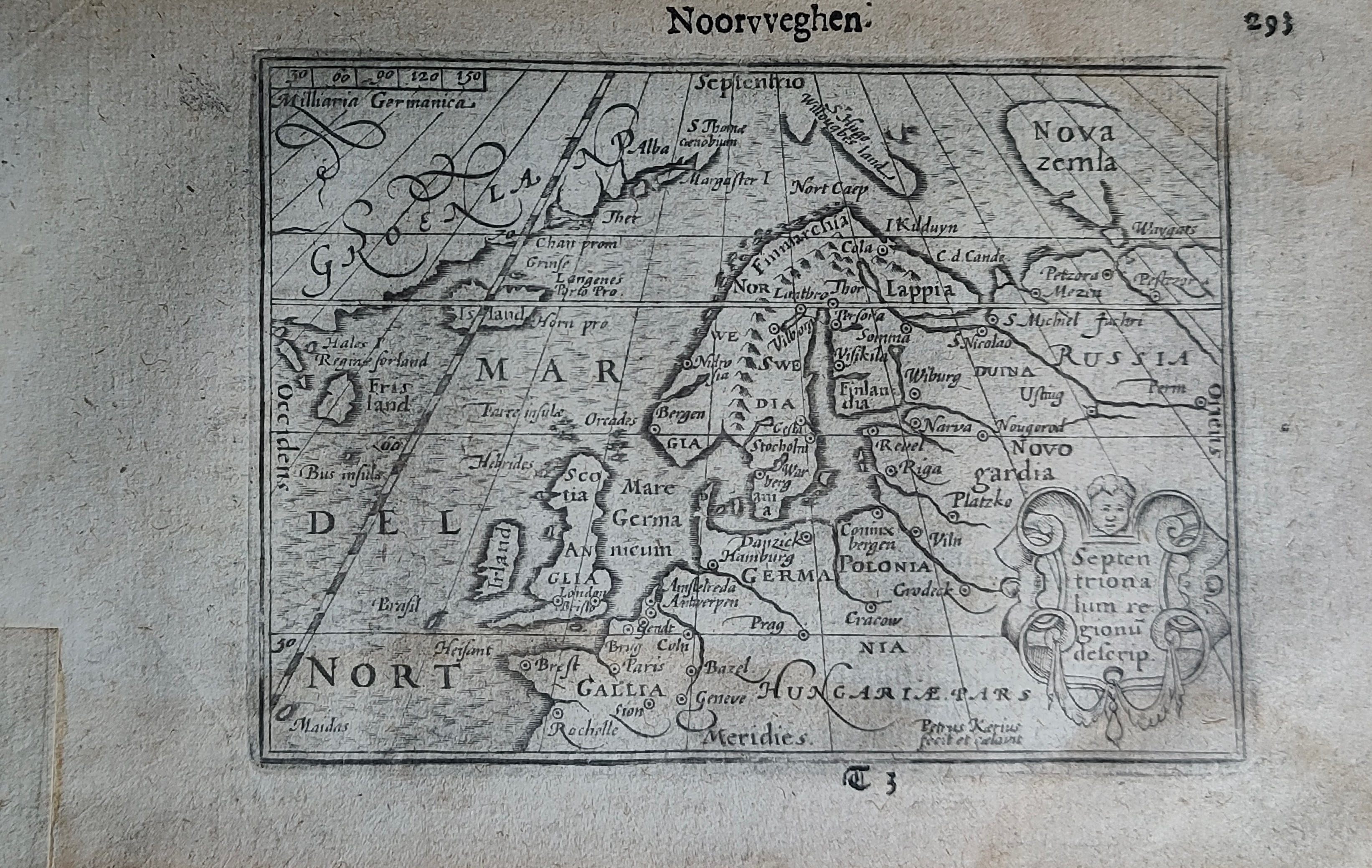
Map title
Noorvveghen
Author
Bertius
Location shown in map
North Europe
Edition date
Circa 1606
Edition place
Amsterdam
Editor
Atlas
Price
300 Euro
State
[mint/EXCELLENT/very good/good/fair/mediocre/poor]
Color
Black/white
Verso
Duch text pag.294
Size
Plate: cm (12 x 9) inches (4.72 x 3.54) Paper: cm (18 x 11) inches (7.09 x 4.33)
Technique
Copper engraving
Note
Reference
Wiki
Here for more info
In stock
Sold
Info
info@thetreasuremaps.com
Code
#1253
×
![Noorvveghen by Bertius, North Europe, Circa 1606]()
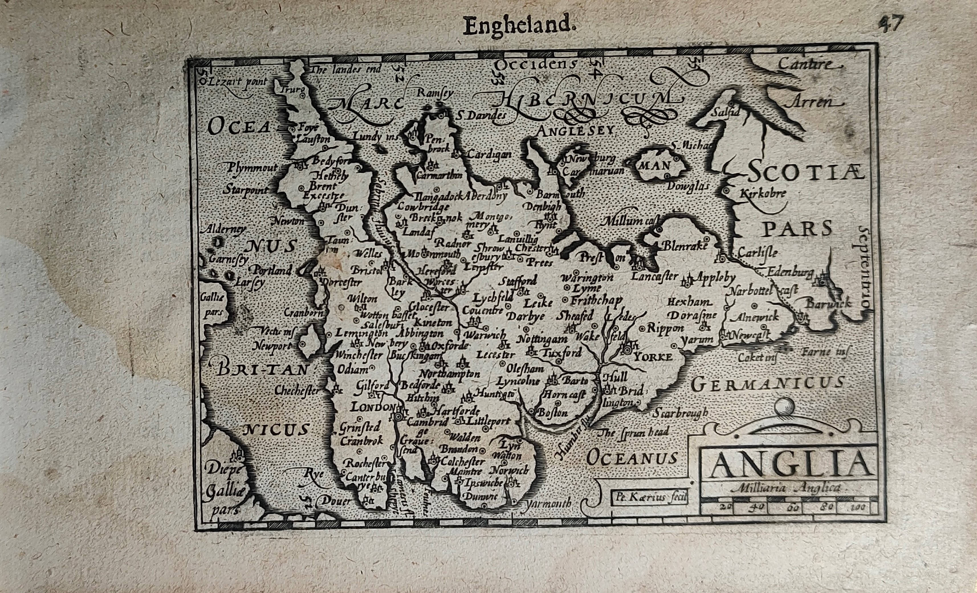
Map title
Engheland
Author
Bertius
Location shown in map
England
Edition date
Circa 1606
Edition place
Amsterdam
Editor
Atlas
Price
200 Euro
State
[mint/EXCELLENT/very good/good/fair/mediocre/poor]
Color
Black/white
Verso
Duch text pag.48
Size
Plate: cm (12 x 9) inches (4.72 x 3.54) Paper: cm (18 x 11) inches (7.09 x 4.33)
Technique
Copper engraving
Note
Reference
Wiki
Here for more info
In stock
Available
Info
info@thetreasuremaps.com
Code
#1254
×
![Engheland by Bertius, England, Circa 1606]()
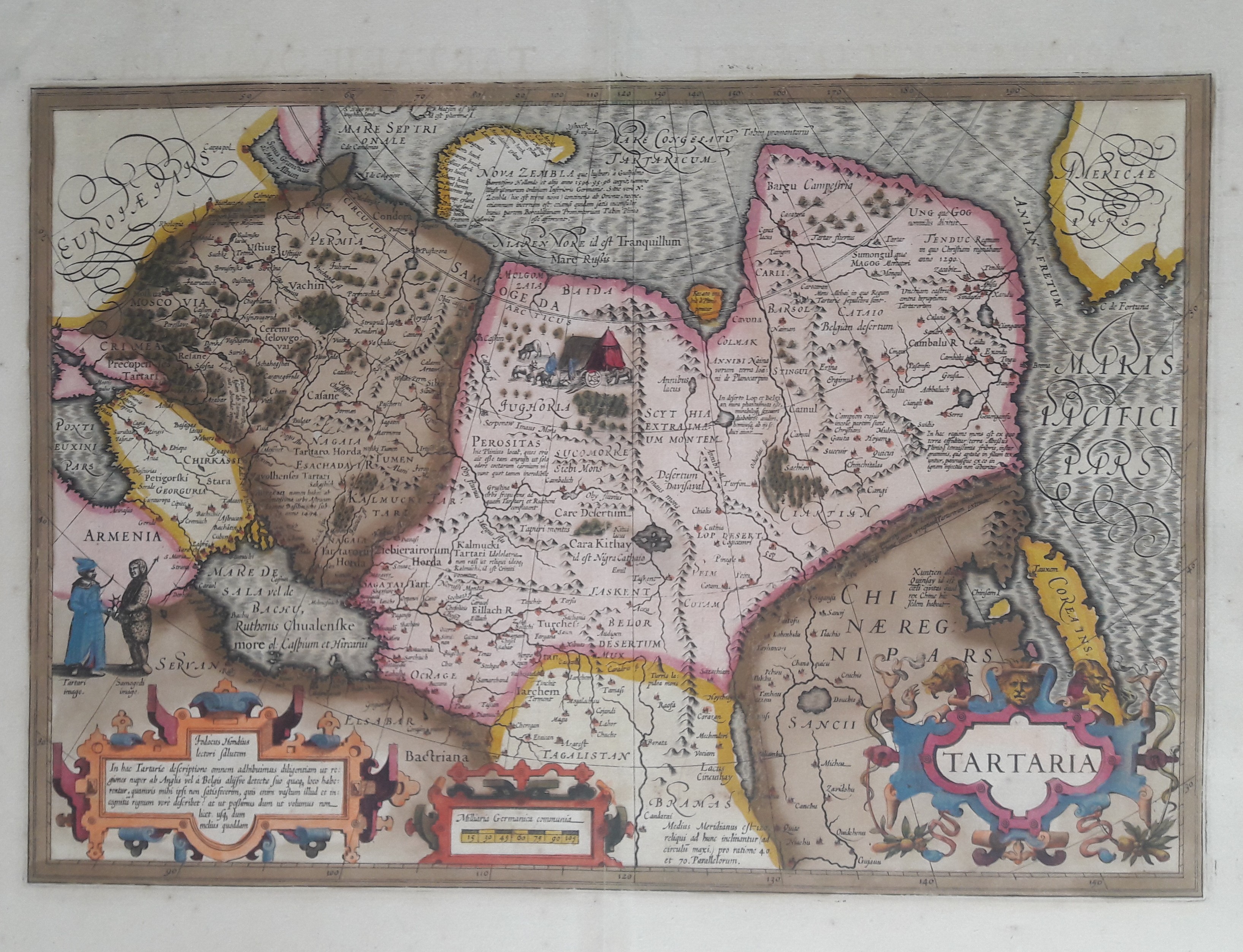
Map title
Tartaria
Author
Hondius
Location shown in map
Russia
Edition date
1606
Edition place
Amsterdam
Editor
Atlas
Atlas Maioris
Price
600 Euro
State
[mint/EXCELLENT/very good/good/fair/mediocre/poor]
Color
Old colors
Verso
Franch text 336
Size
Plate: cm (49 x 33) inches (19.29 x 12.99) Paper: cm (58 x 47) inches (22.83 x 18.5)
Technique
Copper engraving
Note
Professionally repaired
Reference
Wiki
Here for more info
In stock
Available
Info
info@thetreasuremaps.com
Code
#0656
×
![Tartaria by Hondius, Russia, 1606]()
Map title
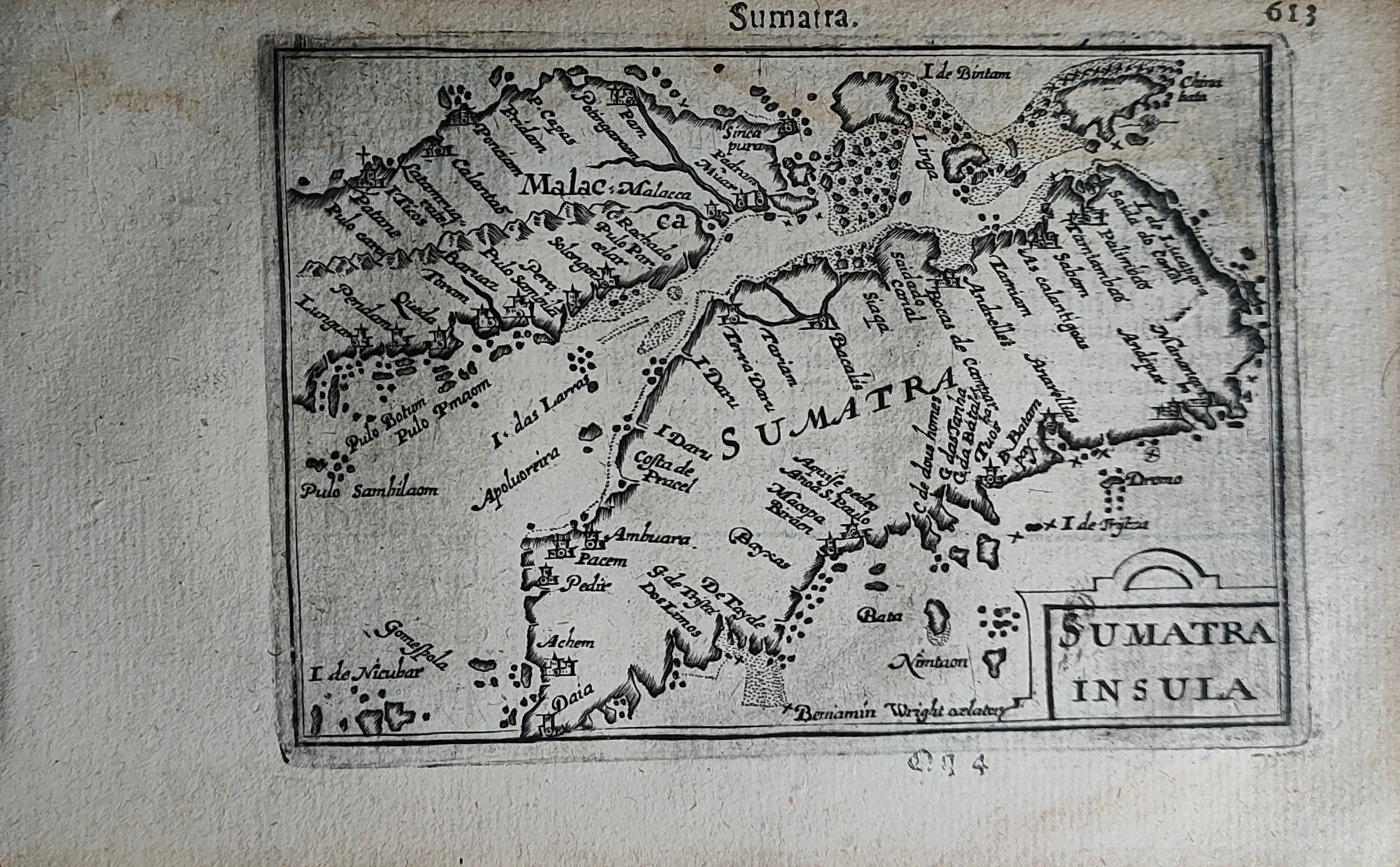
Sumatra
Author
Bertius
Location shown in map
Sumatra
Edition date
Circa 1606
Edition place
Amsterdam
Editor
Atlas
Price
300 Euro
State
[mint/EXCELLENT/very good/good/fair/mediocre/poor]
Color
Black/white
Verso
Duch text pag.614
Size
Plate: cm (12 x 9) inches (4.72 x 3.54) Paper: cm (18 x 11) inches (7.09 x 4.33)
Technique
Copper engraving
Note
Reference
Wiki
Here for more info
In stock
Available
Info
info@thetreasuremaps.com
Code
#1250
Sumatra
Author
Bertius
Location shown in map
Sumatra
Edition date
Circa 1606
Edition place
Amsterdam
Editor
Atlas
Price
300 Euro
State
[mint/EXCELLENT/very good/good/fair/mediocre/poor]
Color
Black/white
Verso
Duch text pag.614
Size
Plate: cm (12 x 9) inches (4.72 x 3.54) Paper: cm (18 x 11) inches (7.09 x 4.33)
Technique
Copper engraving
Note
Reference
Wiki
Here for more info
In stock
Available
Info
info@thetreasuremaps.com
Code
#1250
×
![Sumatra by Bertius, Sumatra, Circa 1606]()
Map title
Sumatra
Author
Gastaldi
Location shown in map
Sumatra
Edition date
1606
Edition place
Venice
Editor
Giambattista Ramusio
Atlas
Delle navigazioni e viaggi
Price
Please ask: info@thetreasuremaps.com
State
[mint/excellent/VERY GOOD/good/fair/mediocre/poor]
Color
Black/white
Verso
pag.371
Size
Plate: cm (36 x 27) inches (14.17 x 10.63) Paper: cm (39 x 29) inches (15.35 x 11.42)
Technique
Woodcut
Note
Decorated with sea monsters and sailing ships.
Reference
--
Wiki
Here for more info
In stock
Available
Info
info@thetreasuremaps.com
Code
#0751
Sumatra
Author
Gastaldi
Location shown in map
Sumatra
Edition date
1606
Edition place
Venice
Editor
Giambattista Ramusio
Atlas
Delle navigazioni e viaggi
Price
Please ask: info@thetreasuremaps.com
State
[mint/excellent/VERY GOOD/good/fair/mediocre/poor]
Color
Black/white
Verso
pag.371
Size
Plate: cm (36 x 27) inches (14.17 x 10.63) Paper: cm (39 x 29) inches (15.35 x 11.42)
Technique
Woodcut
Note
Decorated with sea monsters and sailing ships.
Reference
--
Wiki
Here for more info
In stock
Available
Info
info@thetreasuremaps.com
Code
#0751
×
![Sumatra by Gastaldi, Sumatra, 1606]()
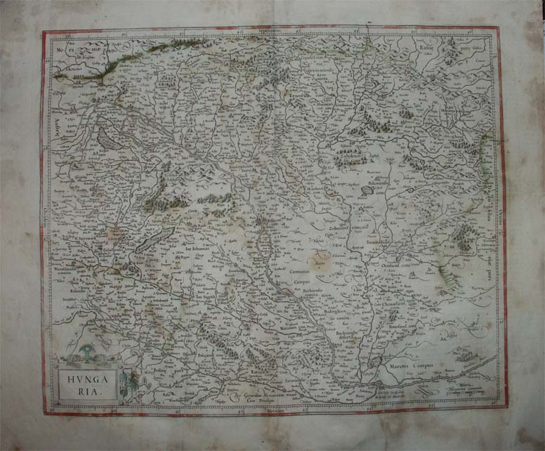
Map title
Hungaria
Author
Mercator
Location shown in map
Hungary
Edition date
1606
Edition place
Amsterdam
Editor
--
Atlas
Mercator-Hondius Atlas.
Price
200 Euro
State
[mint/excellent/very good/GOOD/fair/mediocre/poor]
Color
Black/white
Verso
French text
Size
Plate: cm (41.9 x 36.8) inches (16.5 x 14.49) Paper: cm (55.9 x 45.7) inches (22.01 x 17.99)
Technique
Copper engraving
Note
No particular notes for this maps
Reference
--
Wiki
Here for more info
In stock
Available
Info
info@thetreasuremaps.com
Code
#0130
×
![Hungaria by Mercator, Hungary, 1606]()
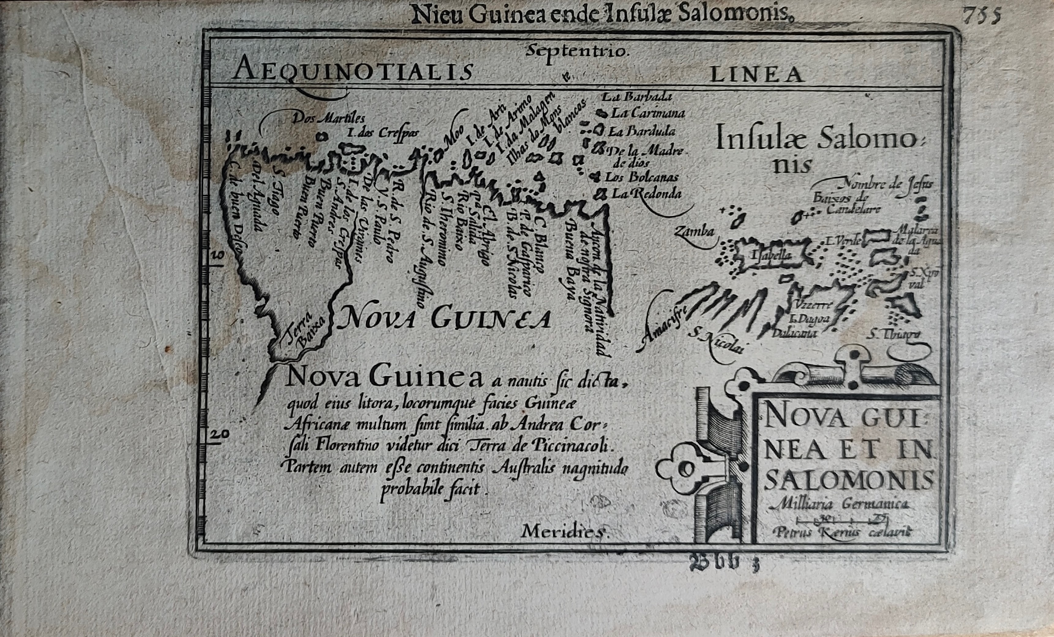
Map title
Nieu Guinea ende Insulae Salomonis
Author
Bertius
Location shown in map
New Guinea
Edition date
Circa 1606
Edition place
Amsterdam
Editor
Atlas
Price
300 Euro
State
[mint/EXCELLENT/very good/good/fair/mediocre/poor]
Color
Black/white
Verso
Duch text pag.756
Size
Plate: cm (12 x 9) inches (4.72 x 3.54) Paper: cm (18 x 11) inches (7.09 x 4.33)
Technique
Copper engraving
Note
Reference
Wiki
Here for more info
In stock
Available
Info
info@thetreasuremaps.com
Code
#1249
×
![Nieu Guinea ende Insulae Salomonis by Bertius, New Guinea, Circa 1606]()