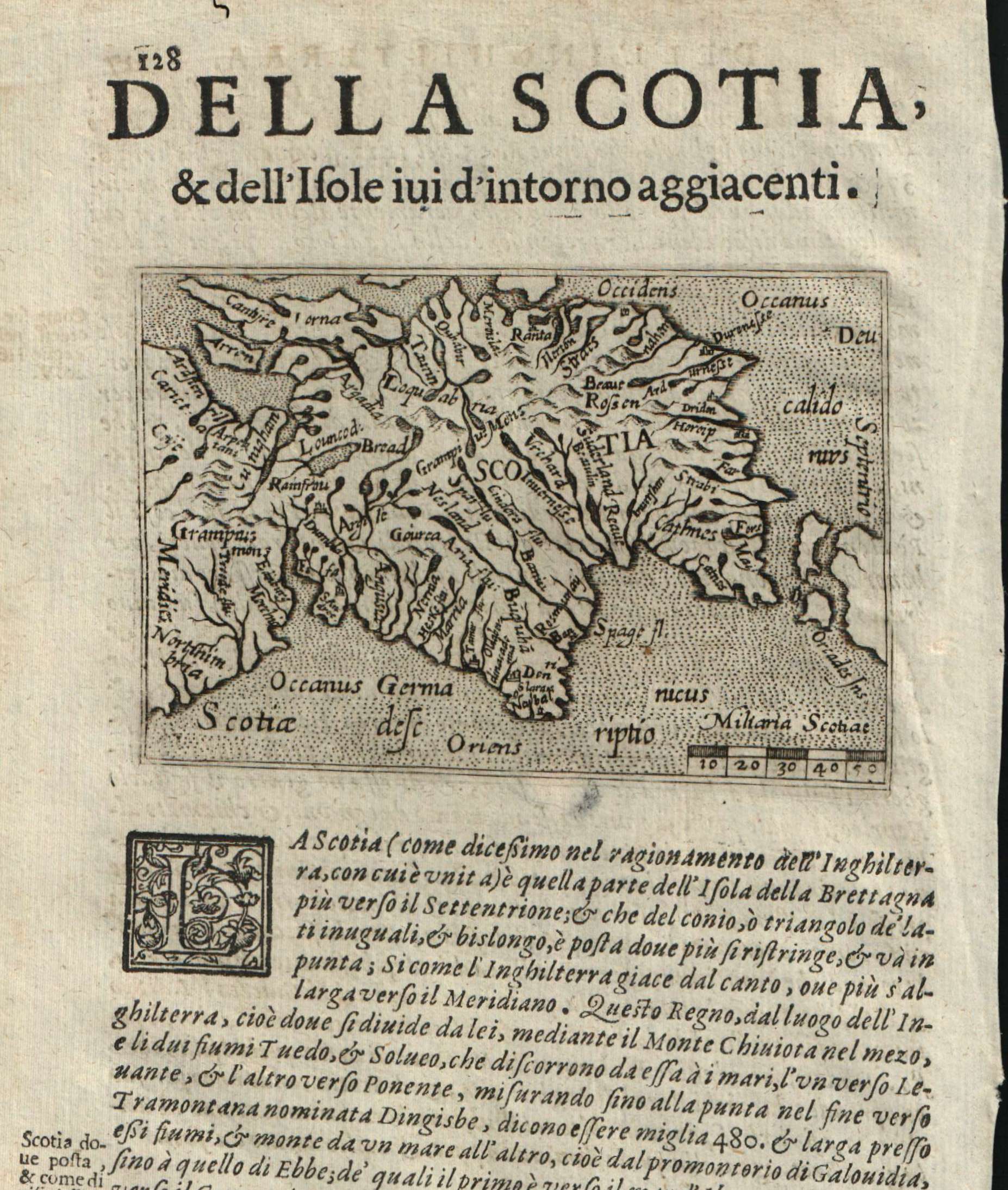
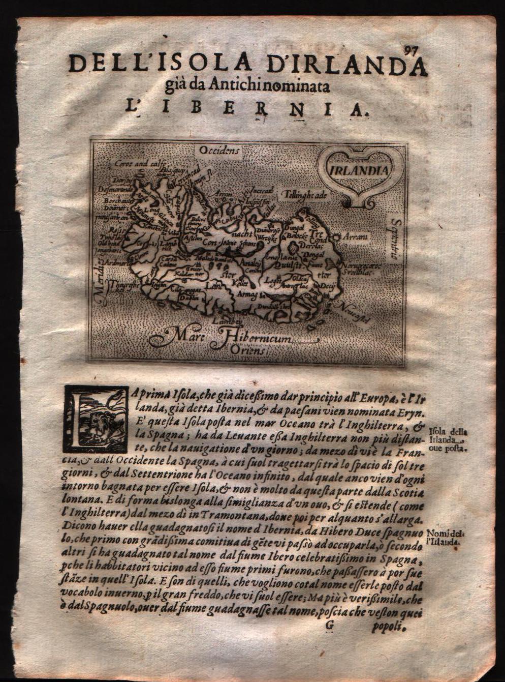
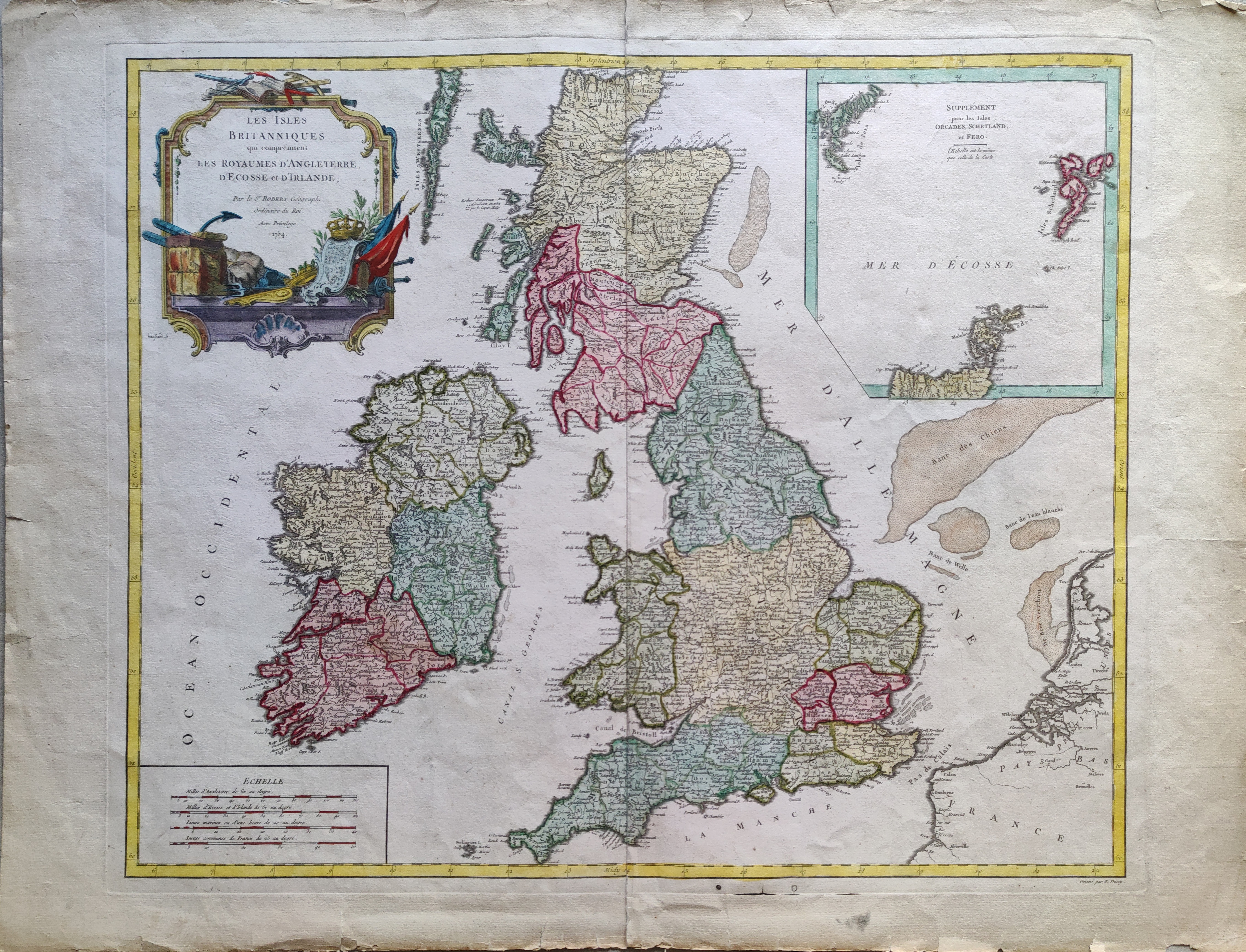
British Isles
Map title
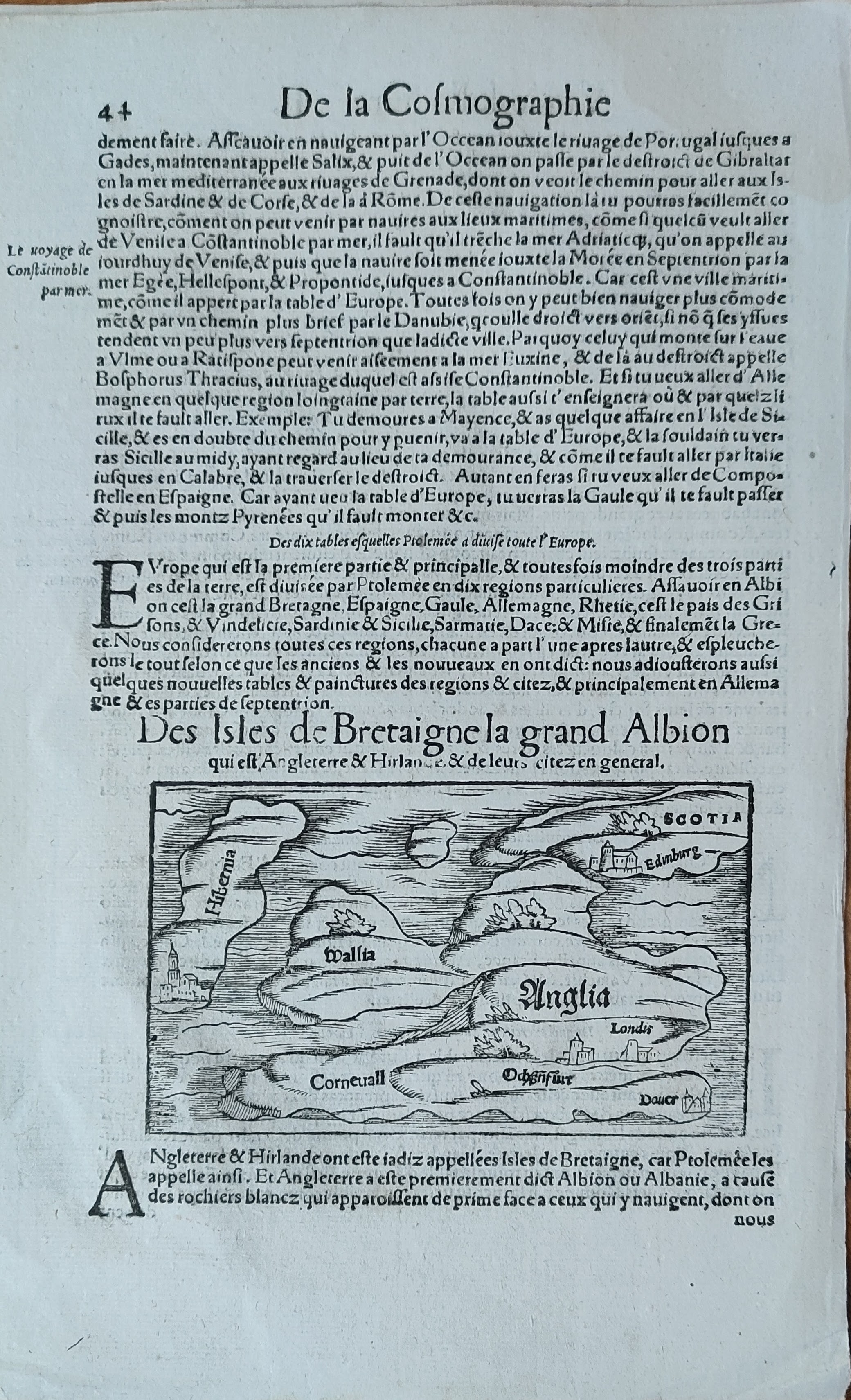
Des isles de Bretaigne la gran Albion
Author
Munster
Location shown in map
England
Edition date
Circa 1552
Edition place
Basel
Editor
Henrich Petri
Atlas
Cosmographia Universalis
Price
150 Euro
State
[mint/EXCELLENT/very good/good/fair/mediocre/poor]
Color
Black/white
Verso
French text pag.43
Size
Plate: cm (13 x 8) inches (5.12 x 3.15) Paper: cm (20 x 31) inches (7.87 x 12.2)
Technique
Woodcut
Note
Reference
Wiki
Here for more info
In stock
Available
Info
info@thetreasuremaps.com
Code
#0954
×
![]()
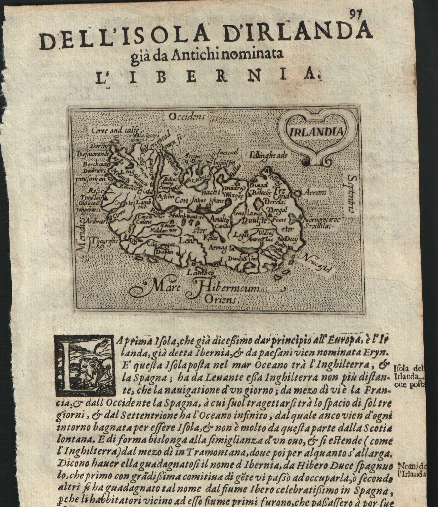
Map title
Anglia et Hibernia nova
Author
Ruscelli
Location shown in map
British Isles
Edition date
1561
Edition place
Venice
Editor
Vincenzo Valgrisi
Atlas
La Geographia di Claudio Tolomeo
Price
300 Euro
State
[mint/EXCELLENT/very good/good/fair/mediocre/poor]
Color
Black/white
Verso
Size
Plate: cm (26 x 19) inches (10.24 x 7.48) Paper: cm (27.9 x 20.3) inches (10.98 x 7.99)
Technique
Copper engraving
Note
No particular notes for this maps.
Reference
--
Wiki
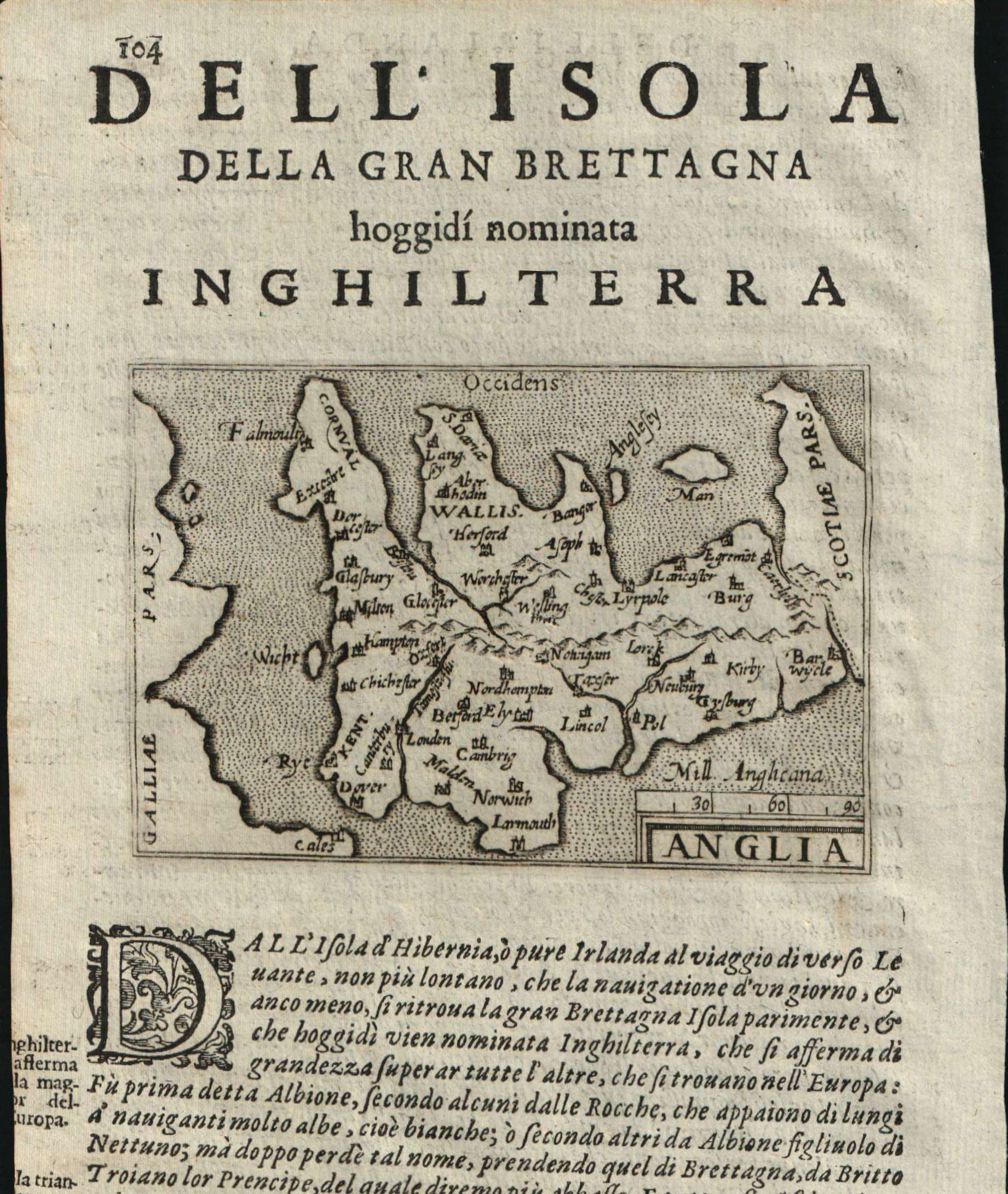
Here for more info
In stock
Available
Info
info@thetreasuremaps.com
Code
#0769
Anglia et Hibernia nova
Author
Ruscelli
Location shown in map
British Isles
Edition date
1561
Edition place
Venice
Editor
Vincenzo Valgrisi
Atlas
La Geographia di Claudio Tolomeo
Price
300 Euro
State
[mint/EXCELLENT/very good/good/fair/mediocre/poor]
Color
Black/white
Verso
Size
Plate: cm (26 x 19) inches (10.24 x 7.48) Paper: cm (27.9 x 20.3) inches (10.98 x 7.99)
Technique
Copper engraving
Note
No particular notes for this maps.
Reference
--
Wiki
Here for more info
In stock
Available
Info
info@thetreasuremaps.com
Code
#0769
×
![]()

Map title
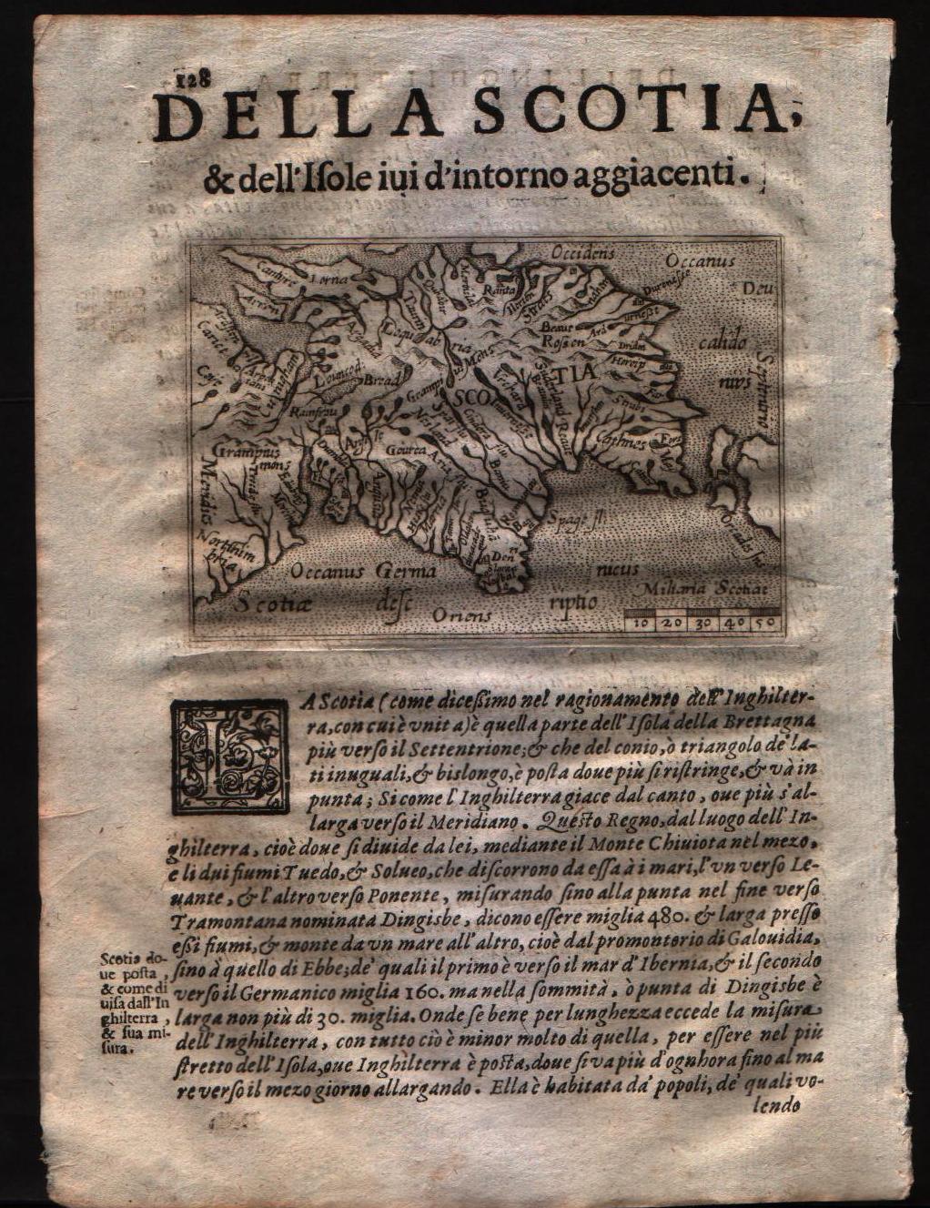
Angliae Heptarchia
Author
Location shown in map
England
Edition date
1574
Edition place
--
Editor
--
Atlas
?? -- ??
Price
Please ask: info@thetreasuremaps.com
State
[mint/excellent/very good/GOOD/fair/mediocre/poor]
Color
Black/white
Verso
Size
Plate: cm (27.9 x 17.8) inches (10.98 x 7.01) Paper: cm (27.9 x 17.8) inches (10.98 x 7.01)
Technique
Copper engraving
Note
The map is glued to a '800 century paper
Reference
--
Wiki
Here for more info
In stock
Sold
Info
info@thetreasuremaps.com
Code
#0429
×
![]()
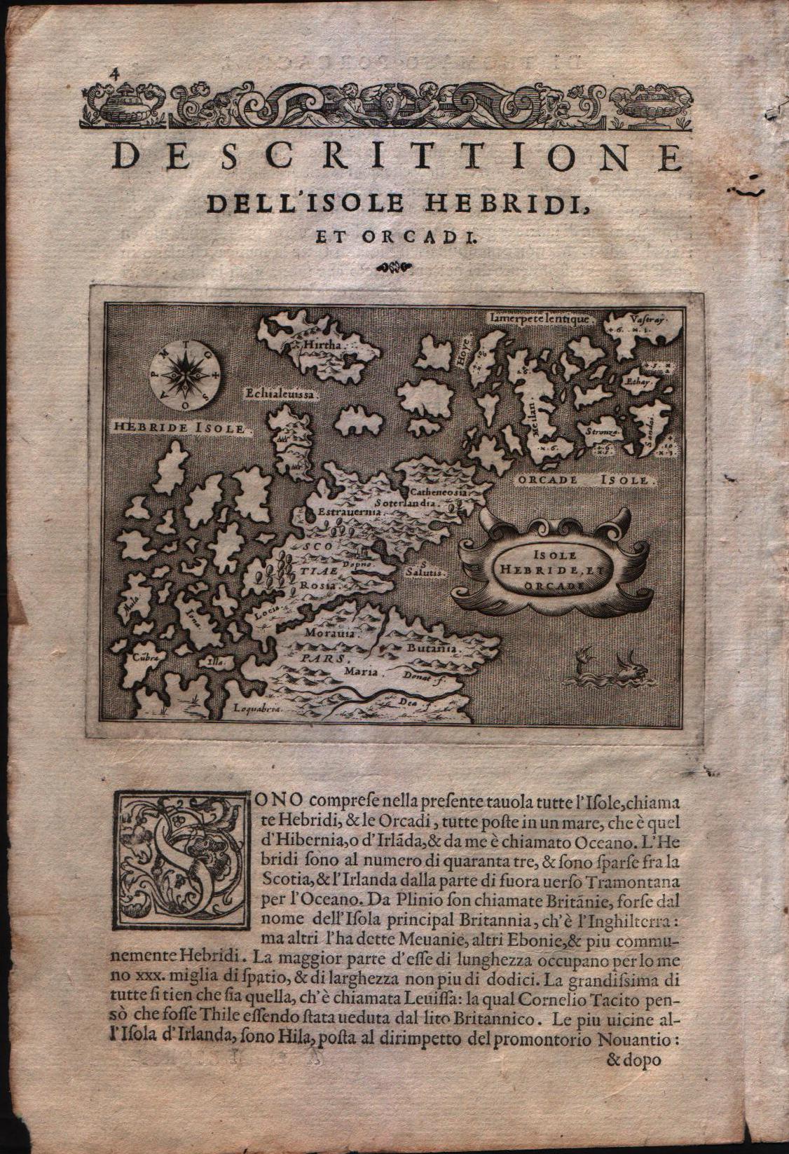
Map title
Descrittione dell'isole Hebridi et Orcadi
Author
Porcacchi
Location shown in map
Scottish islands - The Henrides and Orkneys
Edition date
1576
Edition place
Venice
Editor
--
Atlas
L'Isole piu famose del mondo -- S. Galignani and G. Porro
Price
Please ask: info@thetreasuremaps.com
State
[MINT/excellent/very good/good/fair/mediocre/poor]
Color
Black/white
Verso
Italian text pag.4
Size
Plate: cm (15.2 x 11.4) inches (5.98 x 4.49) Paper: cm (19 x 27.9) inches (7.48 x 10.98)
Technique
Copper engraving
Note
No particular notes for this maps
Reference
Genoa pubblic library "Civica Berio"
Wiki
Here for more info
In stock
Available
Info
info@thetreasuremaps.com
Code
#0103
×
![]()
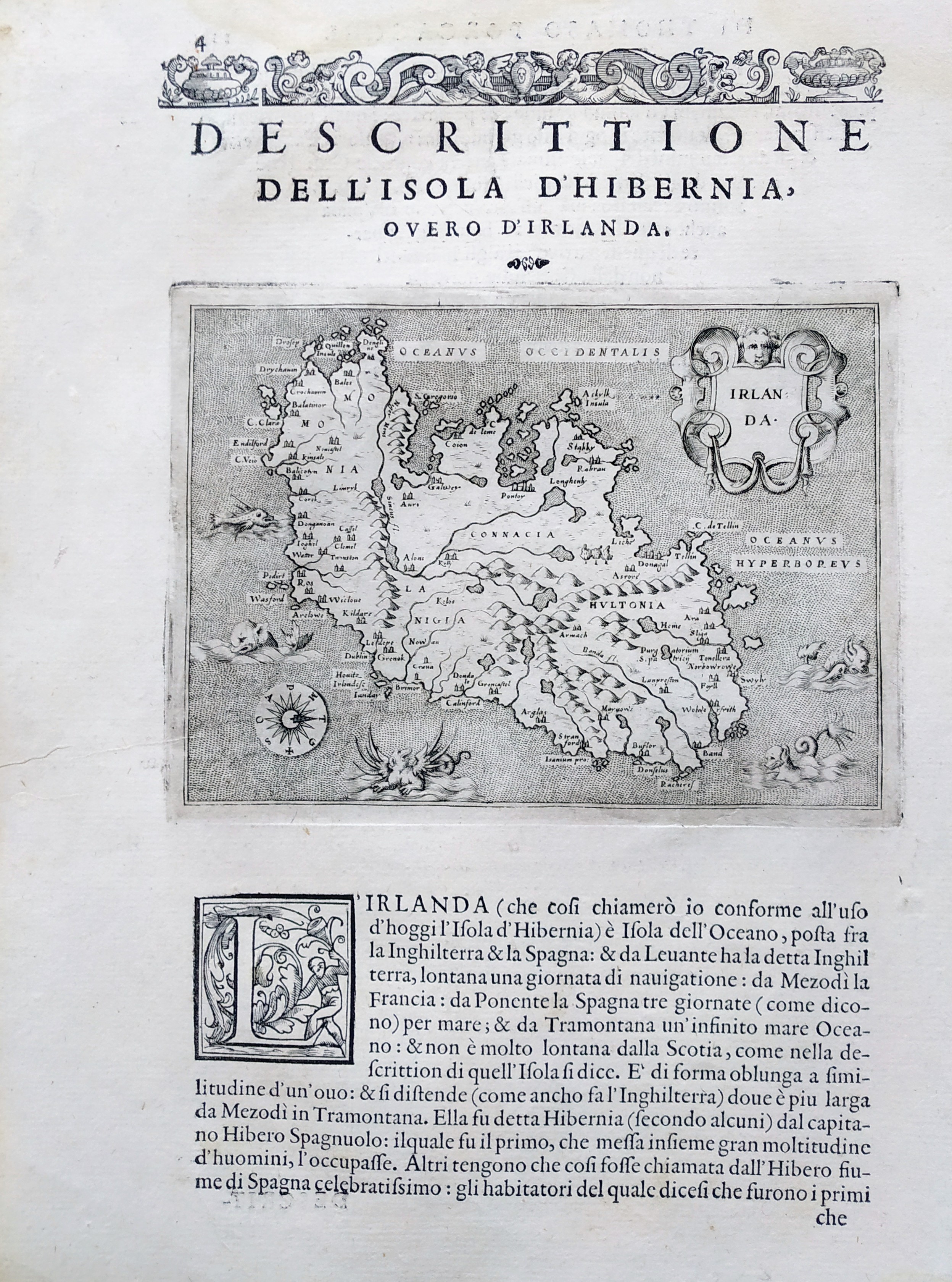
Map title
Descrittione del Mappamondo
Author
Porcacchi
Location shown in map
Ireland
Edition date
1576
Edition place
Venice
Editor
--
Atlas
L'Isole piu famose del mondo -- S. Galignani and G. Porro
Price
Please ask: info@thetreasuremaps.com
State
[mint/EXCELLENT/very good/good/fair/mediocre/poor]
Color
Black/white
Verso
Italian text pag.11
Size
Plate: cm (15.2 x 11.4) inches (5.98 x 4.49) Paper: cm (20.3 x 29.2) inches (7.99 x 11.5)
Technique
Copper engraving
Note
Reference
--
Wiki
Here for more info
In stock
Available
Info
info@thetreasuremaps.com
Code
#0838
×
![]()
Map title
Descrittione dell'isola d'Inghilterra
Author
Porcacchi
Location shown in map
England
Edition date
1576
Edition place
Venice
Editor
--
Atlas
L'Isole piu famose del mondo -- S. Galignani and G. Porro
Price
Please ask: info@thetreasuremaps.com
State
[MINT/excellent/very good/good/fair/mediocre/poor]
Color
Black/white
Verso
Italian text pag.15
Size
Plate: cm (15.2 x 11.4) inches (5.98 x 4.49) Paper: cm (19 x 27.9) inches (7.48 x 10.98)
Technique
Copper engraving
Note
No particular notes for this maps
Reference
Genoa pubblic library "Civica Berio"
Wiki
Here for more info
In stock
Available
Info
info@thetreasuremaps.com
Code
#0101
×
![]()
Map title
Descrittione dell'isola di Scotia
Author
Porcacchi
Location shown in map
Scotland
Edition date
1576
Edition place
Venice
Editor
--
Atlas
L'Isole piu famose del mondo -- S. Galignani and G. Porro
Price
Please ask: info@thetreasuremaps.com
State
[MINT/excellent/very good/good/fair/mediocre/poor]
Color
Black/white
Verso
Italian text pag.23
Size
Plate: cm (15.2 x 11.4) inches (5.98 x 4.49) Paper: cm (19 x 27.9) inches (7.48 x 10.98)
Technique
Copper engraving
Note
No particular notes for this maps
Reference
Genoa pubblic library "Civica Berio"
Wiki
Here for more info
In stock
Available
Info
info@thetreasuremaps.com
Code
#0104
×
![]()
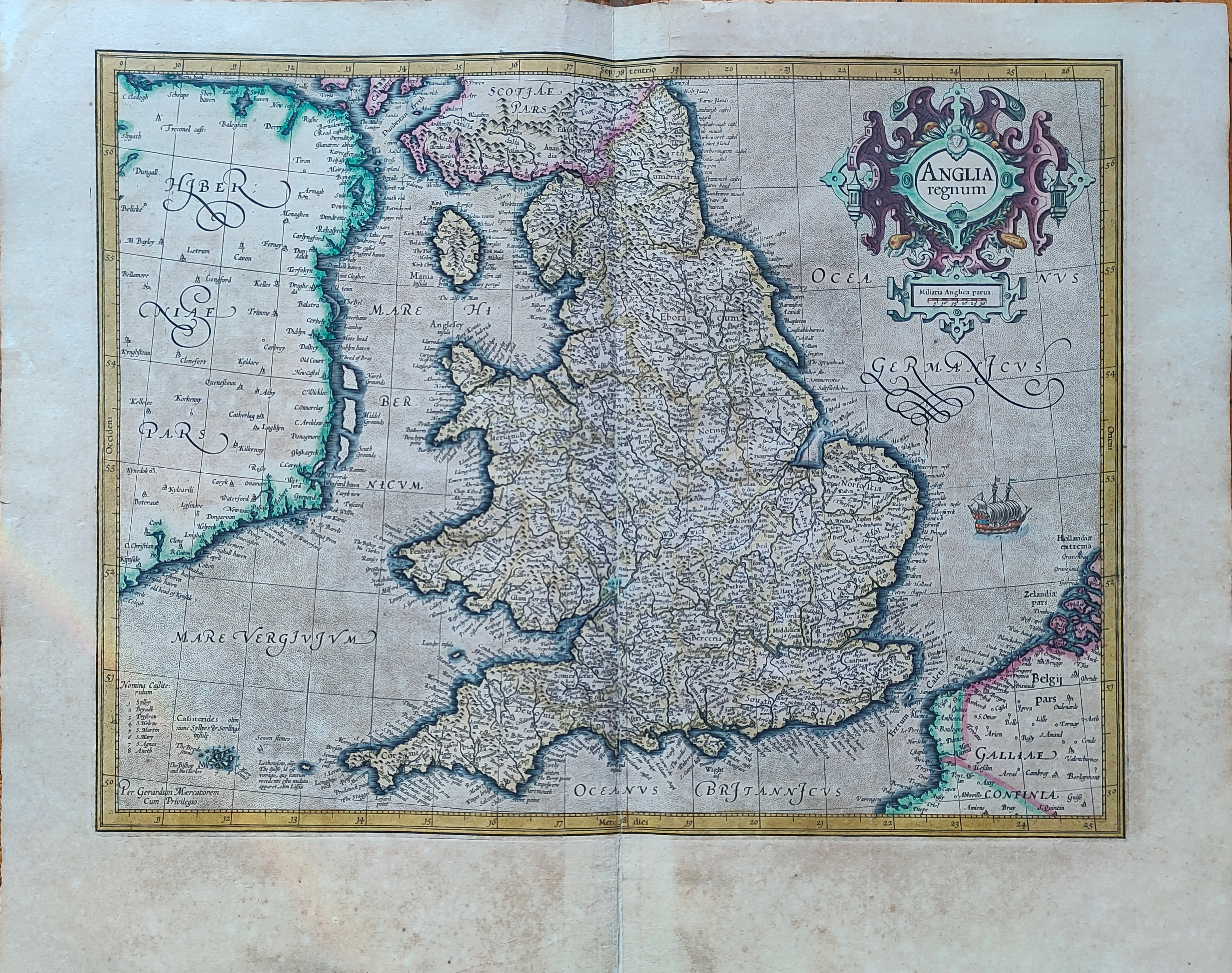
Map title
Angliae regni
Author
Ortelius
Location shown in map
England
Edition date
1579
Edition place
Antwerp
Editor
--
Atlas
Theatrum Orbis Terrarum
Price
700 Euro
State
[mint/excelent/very good/good/FAIR/mediocre/poor]
Color
Black/white
Verso
Latin text pag.10
Size
Plate: cm (46 x 37) inches (18.11 x 14.57) Paper: cm (52 x 49) inches (20.47 x 19.29)
Technique
Copper engraving
Note
No particular notes for this maps.
Reference
Van Den Broecke 117
Wiki
Here for more info
In stock
Available
Info
info@thetreasuremaps.com
Code
#0748
×
![]()
Map title
Scotiae tabula
Author
Ortelius
Location shown in map
Scotland
Edition date
1588
Edition place
Antwerp
Editor
Atlas
Theatrum Orbis Terrarum
Price
800 Euro
State
[mint/EXCELLENT/very good/good/fair/mediocre/poor]
Color
Old colors
Verso
Spanish text pag 10
Size
Plate: cm (47 x 35) inches (18.5 x 13.78) Paper: cm (53 x 42) inches (20.87 x 16.54)
Technique
Copper engraving
Note
Reference
Van Den Broecke 59
Wiki
Here for more info
In stock
Available
Info
info@thetreasuremaps.com
Code
#1160
×
![]()
Map title
Cambriae Typus
Author
Ortelius
Location shown in map
Wales
Edition date
1588
Edition place
Antwerp
Editor
Atlas
Theatrum Orbis Terrarum
Price
700 Euro
State
[mint/EXCELLENT/very good/good/fair/mediocre/poor]
Color
Old colors
Verso
Spanish text
Size
Plate: cm (47 x 35) inches (18.5 x 13.78) Paper: cm (53 x 42) inches (20.87 x 16.54)
Technique
Copper engraving
Note
Reference
Van Den Broecke 62
Wiki
Here for more info
In stock
Available
Info
info@thetreasuremaps.com
Code
#1165
×
![]()
Map title
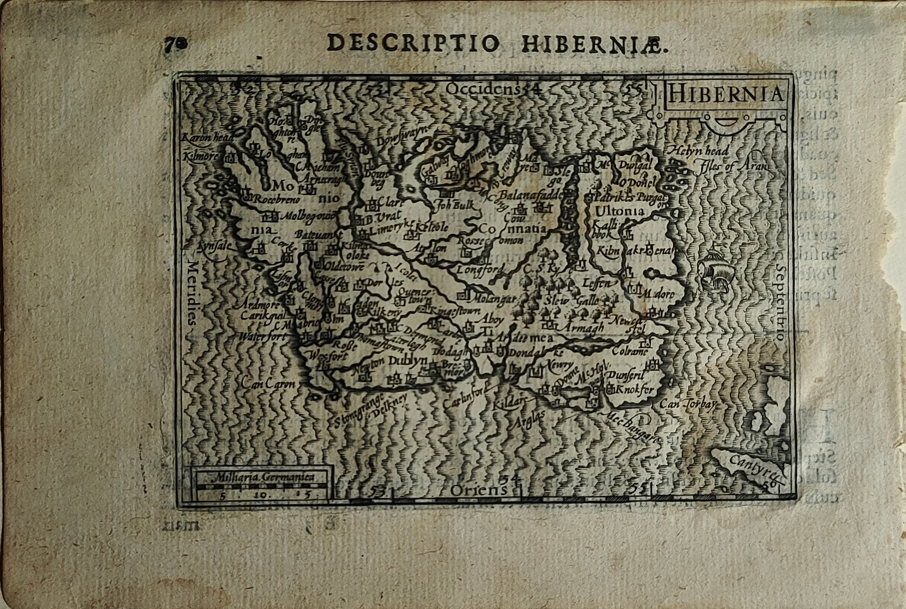
Hibernia
Author
Bertius
Location shown in map
Ireland
Edition date
1600
Edition place
Amsterdam
Editor
--
Atlas
Tabularum geographicarum contractarum
Price
250 Euro
State
[mint/EXCELLENT/very good/good/fair/mediocre/poor]
Color
Black/white
Verso
Latin text
Size
Plate: cm (12 x 8) inches (4.72 x 3.15) Paper: cm (18 x 12) inches (7.09 x 4.72)
Technique
Copper engraving
Note
Reference
Wiki
Here for more info
In stock
Sold
Info
info@thetreasuremaps.com
Code
#1181
×
![]()
Map title
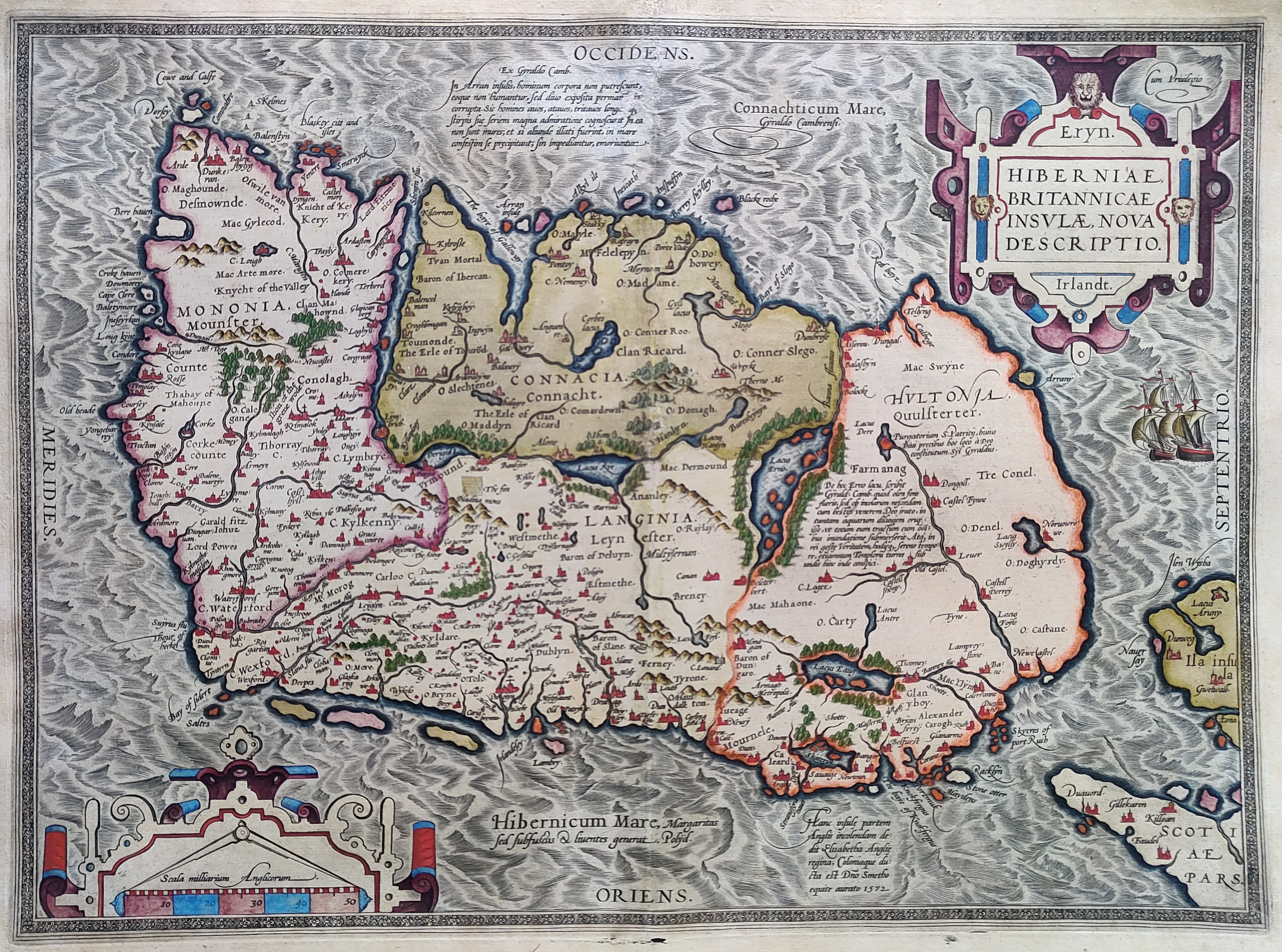
Hiberniae Britannicae insulae nova descriptio
Author
Ortelius
Location shown in map
Ireland
Edition date
1601
Edition place
Antwerp
Editor
--
Atlas
Theatrum Orbis Terrarum
Price
900 Euro
State
[mint/EXCELLENT/very good/good/fair/mediocre/poor]
Color
Old colors
Verso
Latin text pag.14
Size
Plate: cm (48 x 35) inches (18.9 x 13.78) Paper: cm (55 x 43) inches (21.65 x 16.93)
Technique
Copper engraving
Note
Reference
Van Den Broecke 63
Wiki
Here for more info
In stock
Sold
Info
info@thetreasuremaps.com
Code
#1019
×
![]()
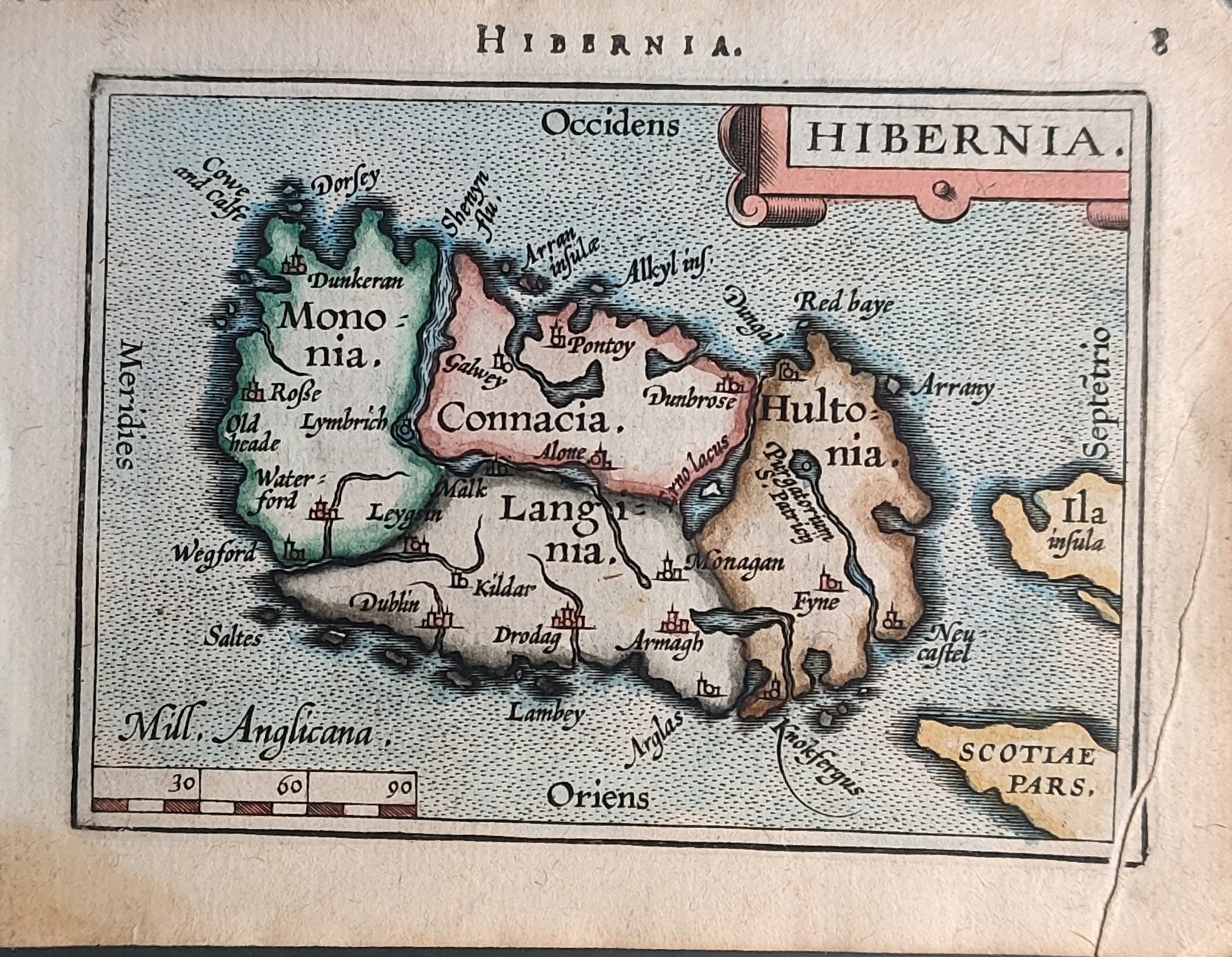
Map title
Hibernia
Author
Ortelius
Location shown in map
Ireland
Edition date
1602
Edition place
Antwerp
Editor
Jean-Baptiste Uriens
Atlas
Abrege du Theatre d'Ortelius
Price
175 Euro
State
[mint/EXCELLENT/very good/good/fair/mediocre/poor]
Color
Old colors
Verso
French text
Size
Plate: cm (11 x 8) inches (4.33 x 3.15) Paper: cm (11 x 8) inches (4.33 x 3.15)
Technique
Copper engraving
Note
Plate 2 map
Reference
Wiki
Here for more info
In stock
Available
Info
info@thetreasuremaps.com
Code
#1079
×
![]()
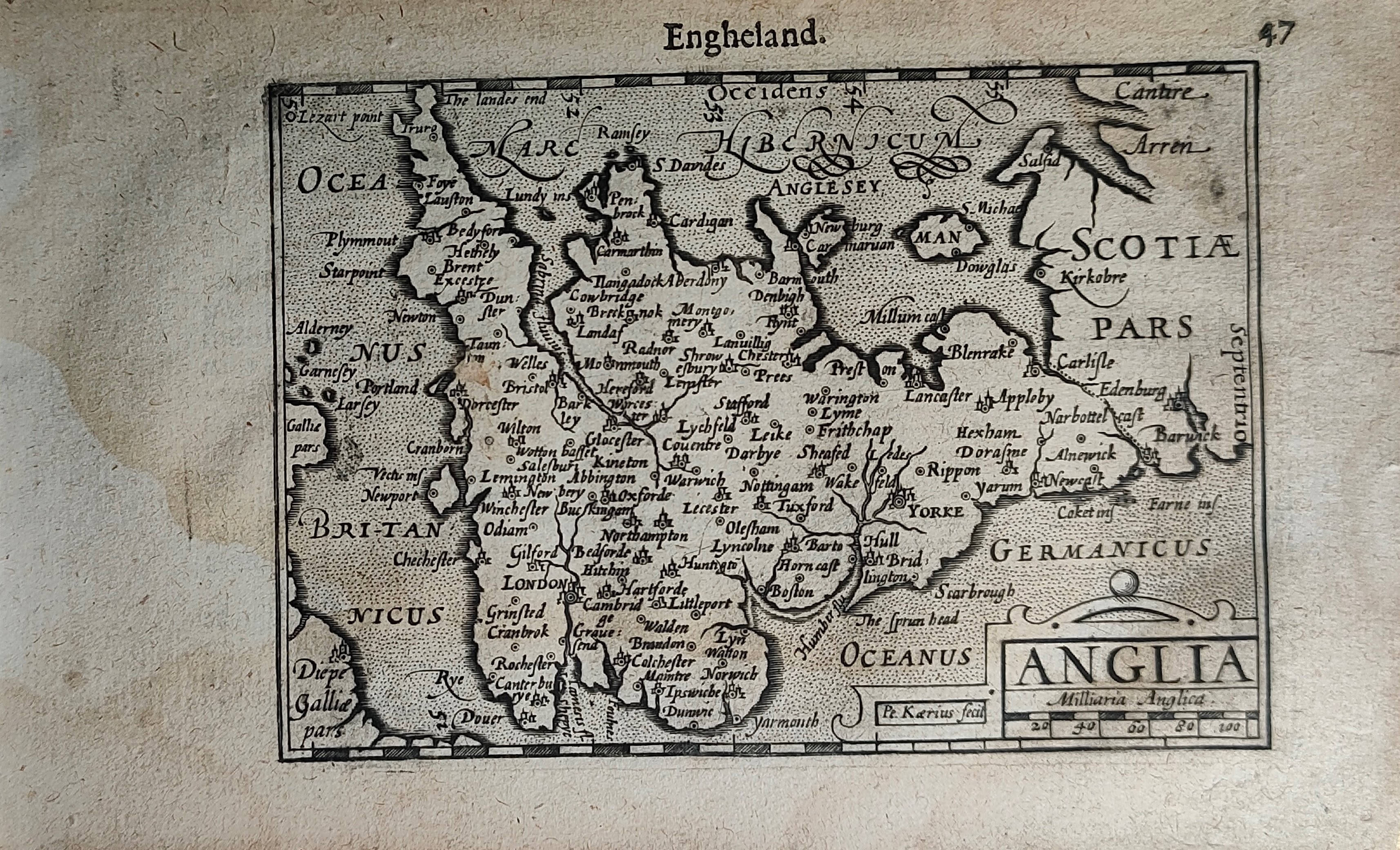
Map title
Engheland
Author
Bertius
Location shown in map
England
Edition date
Circa 1606
Edition place
Amsterdam
Editor
Atlas
Price
200 Euro
State
[mint/EXCELLENT/very good/good/fair/mediocre/poor]
Color
Black/white
Verso
Duch text pag.48
Size
Plate: cm (12 x 9) inches (4.72 x 3.54) Paper: cm (18 x 11) inches (7.09 x 4.33)
Technique
Copper engraving
Note
Reference
Wiki
Here for more info
In stock
Available
Info
info@thetreasuremaps.com
Code
#1254
×
![]()
Map title
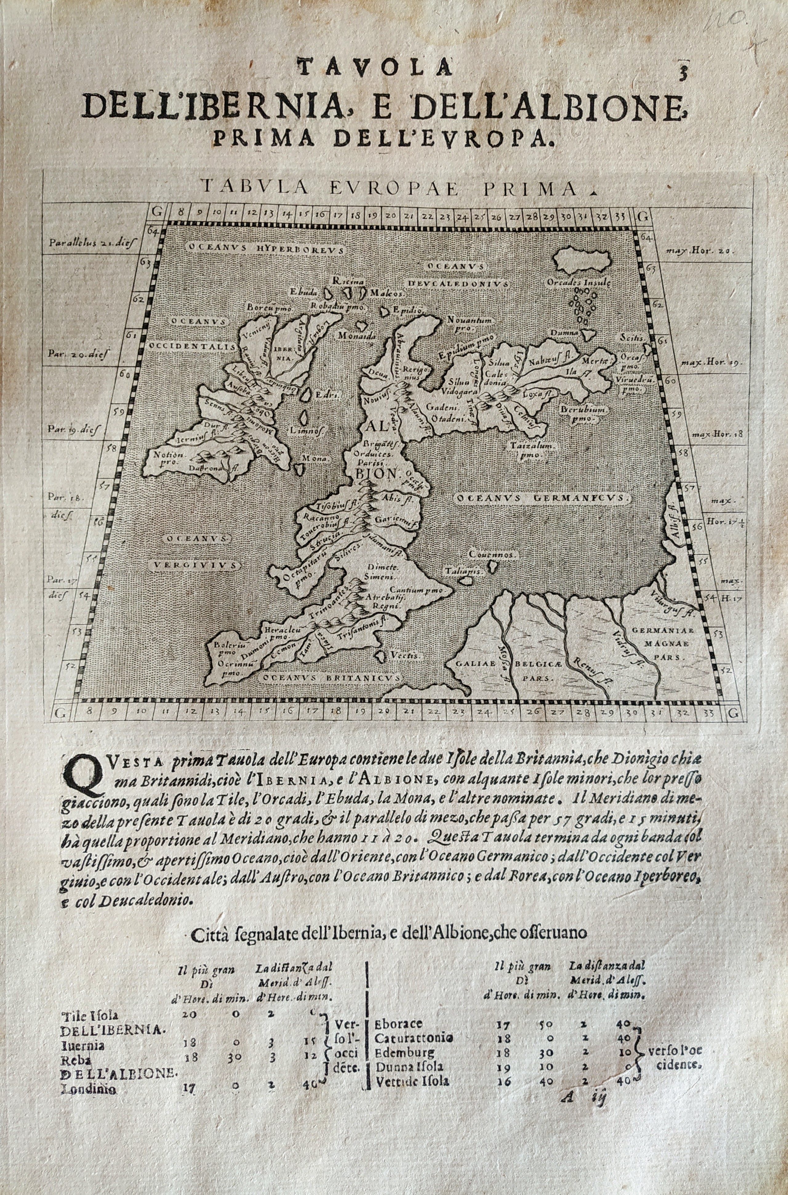
Tabula Europae prima
Author
Magini
Location shown in map
British Isles
Edition date
1621
Edition place
Padova
Editor
Paolo and Francesco Galignani
Atlas
Geografia di Claudio Tolomeo -- Giovanni Antonio Magini
Price
200 Euro
State
[MINT/excellent/very good/good/fair/mediocre/poor]
Color
Black/white
Verso
Italian text
Size
Plate: cm (12.7 x 17.8) inches (5 x 7.01) Paper: cm (20.3 x 30.5) inches (7.99 x 12.01)
Technique
Copper engraving
Note
No particular notes for this maps.
Reference
--
Wiki
Here for more info
In stock
Available
Info
info@thetreasuremaps.com
Code
#0711
×
![]()
Map title
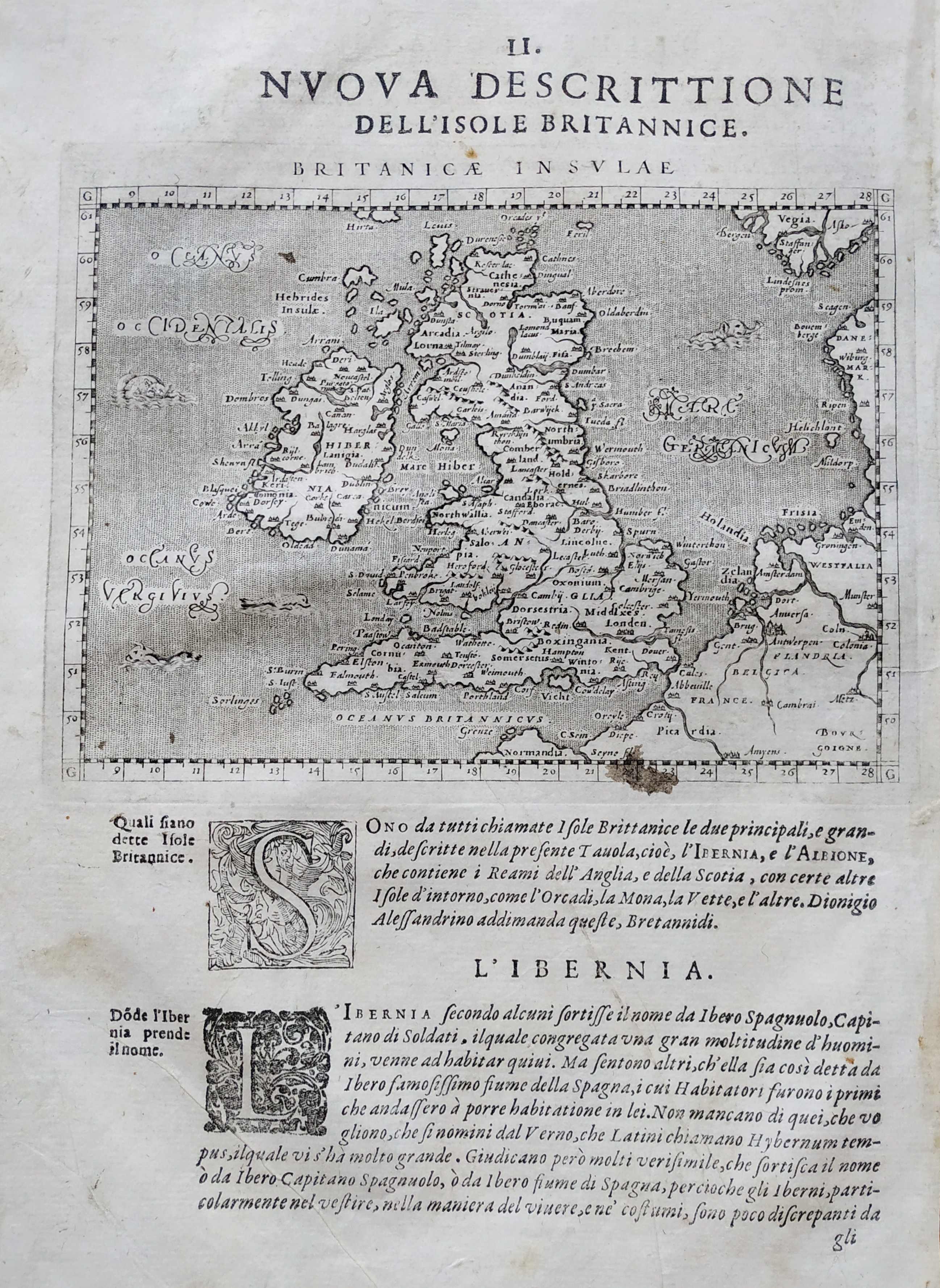
Nova descrittione dell isole britanniche
Author
Magini
Location shown in map
British Isles
Edition date
1621
Edition place
Padova
Editor
Paolo and Francesco Galignani
Atlas
Geografia di Claudio Tolomeo -- Giovanni Antonio Magini
Price
200 Euro
State
[MINT/excellent/very good/good/fair/mediocre/poor]
Color
Black/white
Verso
Italian text pag 24
Size
Plate: cm (17 x 12) inches (6.69 x 4.72) Paper: cm (20.3 x 30.5) inches (7.99 x 12.01)
Technique
Copper engraving
Note
No particular notes for this maps
Reference
--
Wiki
Here for more info
In stock
Available
Info
info@thetreasuremaps.com
Code
#0730
×
![]()
Map title
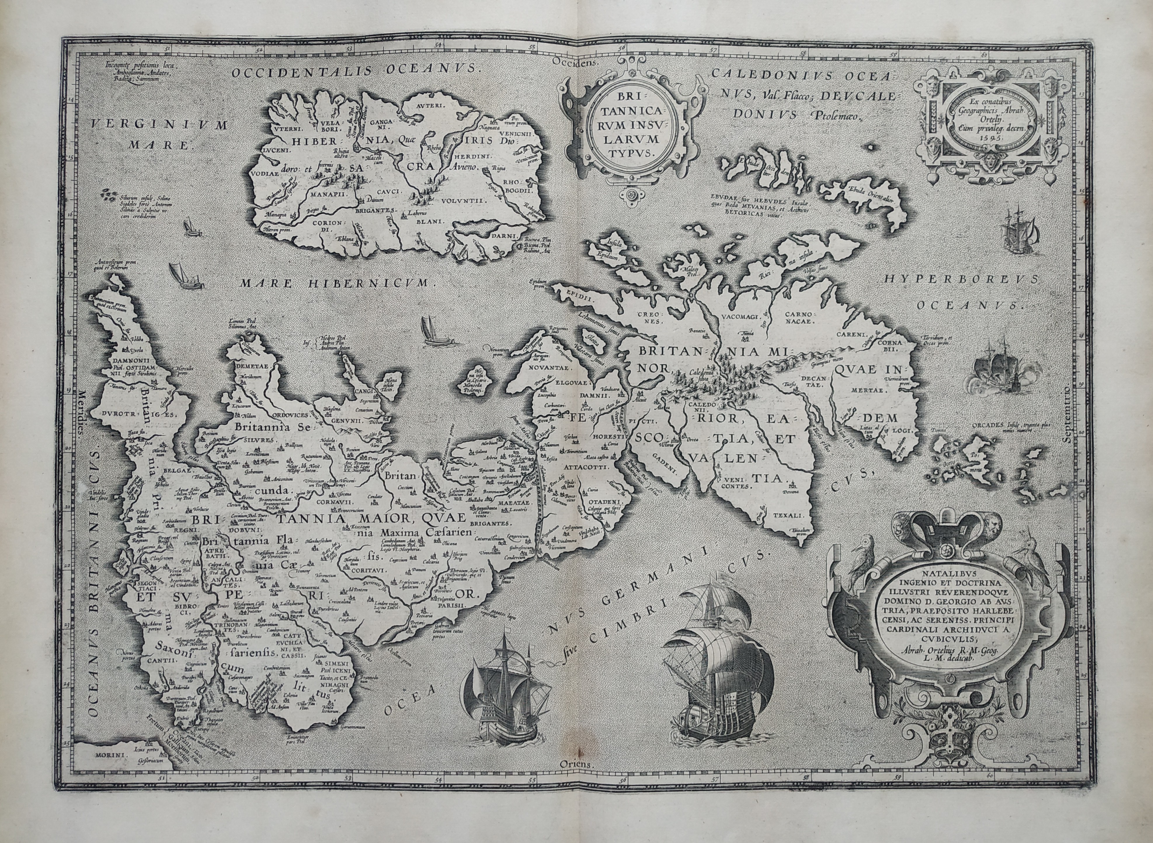
Britanicarum insularum
Author
Ortelius
Location shown in map
England
Edition date
1621
Edition place
Antwerp
Editor
--
Atlas
Theatrum Orbis Terrarum
Price
700 Euro
State
[mint/EXCELLENT/very good/good/fair/mediocre/poor]
Color
Black/white
Verso
Latin text pag.11
Size
Plate: cm (50 x 36) inches (19.69 x 14.17) Paper: cm (57 x 47) inches (22.44 x 18.5)
Technique
Copper engraving
Note
No particular notes for this maps.
Reference
Van Den Broecke 190
Wiki
Here for more info
In stock
Available
Info
info@thetreasuremaps.com
Code
#0778
×
![]()
Map title
Scotiae
Author
Doglioni
Location shown in map
Scotland
Edition date
1623
Edition place
Venice
Editor
Giacomo Sarzina
Atlas
Anfiteatro di Europa
Price
Please ask: info@thetreasuremaps.com
State
[mint/EXCELLENT/very good/good/fair/mediocre/poor]
Color
Black/white
Verso
Italian text pag.127
Size
Plate: cm (11.4 x 8.9) inches (4.49 x 3.5) Paper: cm (15.2 x 22.9) inches (5.98 x 9.02)
Technique
Copper engraving
Note
The maps are copies of the Galle (c.1595) edition of Ortelius.
Reference
--
Wiki
Here for more info
In stock
Available
Info
info@thetreasuremaps.com
Code
#0611
×
![]()
Map title
Irlandia
Author
Doglioni
Location shown in map
Ireland
Edition date
1623
Edition place
Venice
Editor
Giacomo Sarzina
Atlas
Anfiteatro di Europa
Price
Please ask: info@thetreasuremaps.com
State
[mint/EXCELLENT/very good/good/fair/mediocre/poor]
Color
Black/white
Verso
Italian text pag.98
Size
Plate: cm (11.4 x 8.9) inches (4.49 x 3.5) Paper: cm (15.2 x 22.9) inches (5.98 x 9.02)
Technique
Copper engraving
Note
The maps are copies of the Galle (c.1595) edition of Ortelius.
Reference
--
Wiki
Here for more info
In stock
Sold
Info
info@thetreasuremaps.com
Code
#0609
×
![]()
Map title
Scotia
Author
Doglioni
Location shown in map
Scotland
Edition date
1623
Edition place
Venice
Editor
Giacomo Sarzina
Atlas
Anfiteatro di Europa
Price
Please ask: info@thetreasuremaps.com
State
[MINT/excellent/very good/good/fair/mediocre/poor]
Color
Black/white
Verso
Italian text pag.127
Size
Plate: cm (11.4 x 8.9) inches (4.49 x 3.5) Paper: cm (15.2 x 22.9) inches (5.98 x 9.02)
Technique
Copper engraving
Note
The maps are copies of the Galle (c.1595) edition of Ortelius.
Reference
--
Wiki
Here for more info
In stock
Sold
Info
info@thetreasuremaps.com
Code
#0560
×
![]()
Map title
Irlandia
Author
Doglioni
Location shown in map
Ireland
Edition date
1623
Edition place
Venice
Editor
Giacomo Sarzina
Atlas
Anfiteatro di Europa
Price
Please ask: info@thetreasuremaps.com
State
[MINT/excellent/very good/good/fair/mediocre/poor]
Color
Black/white
Verso
Italian text pag.98
Size
Plate: cm (11.4 x 8.9) inches (4.49 x 3.5) Paper: cm (15.2 x 22.9) inches (5.98 x 9.02)
Technique
Copper engraving
Note
The maps are copies of the Galle (c.1595) edition of Ortelius.
Reference
--
Wiki
Here for more info
In stock
Sold
Info
info@thetreasuremaps.com
Code
#0559
×
![]()
Map title
Anglia
Author
Doglioni
Location shown in map
England
Edition date
1623
Edition place
Venice
Editor
Giacomo Sarzina
Atlas
Anfiteatro di Europa
Price
900 Euro
State
[mint/EXCELLENT/very good/good/fair/mediocre/poor]
Color
Black/white
Verso
Italian text pag.103
Size
Plate: cm (11.4 x 8.9) inches (4.49 x 3.5) Paper: cm (15.2 x 22.9) inches (5.98 x 9.02)
Technique
Copper engraving
Note
The maps are copies of the Galle (c.1595) edition of Ortelius.
Reference
--
Wiki
Here for more info
In stock
Available
Info
info@thetreasuremaps.com
Code
#0610
×
![]()
Map title
Anglia regnum
Author
Mercator
Location shown in map
England
Edition date
Circa 1623
Edition place
Amsterdam
Editor
Houndius
Atlas
Mercator-Hondius Atlas.
Price
400 Euro
State
[mint/EXCELLENT/very good/good/fair/mediocre/poor]
Color
Old colors
Verso
Franch text 117
Size
Plate: cm (46 x 36) inches (18.11 x 14.17) Paper: cm (56 x 44) inches (22.05 x 17.32)
Technique
Copper engraving
Note
Reference
Wiki
Here for more info
In stock
Available
Info
info@thetreasuremaps.com
Code
#1195
×
![]()
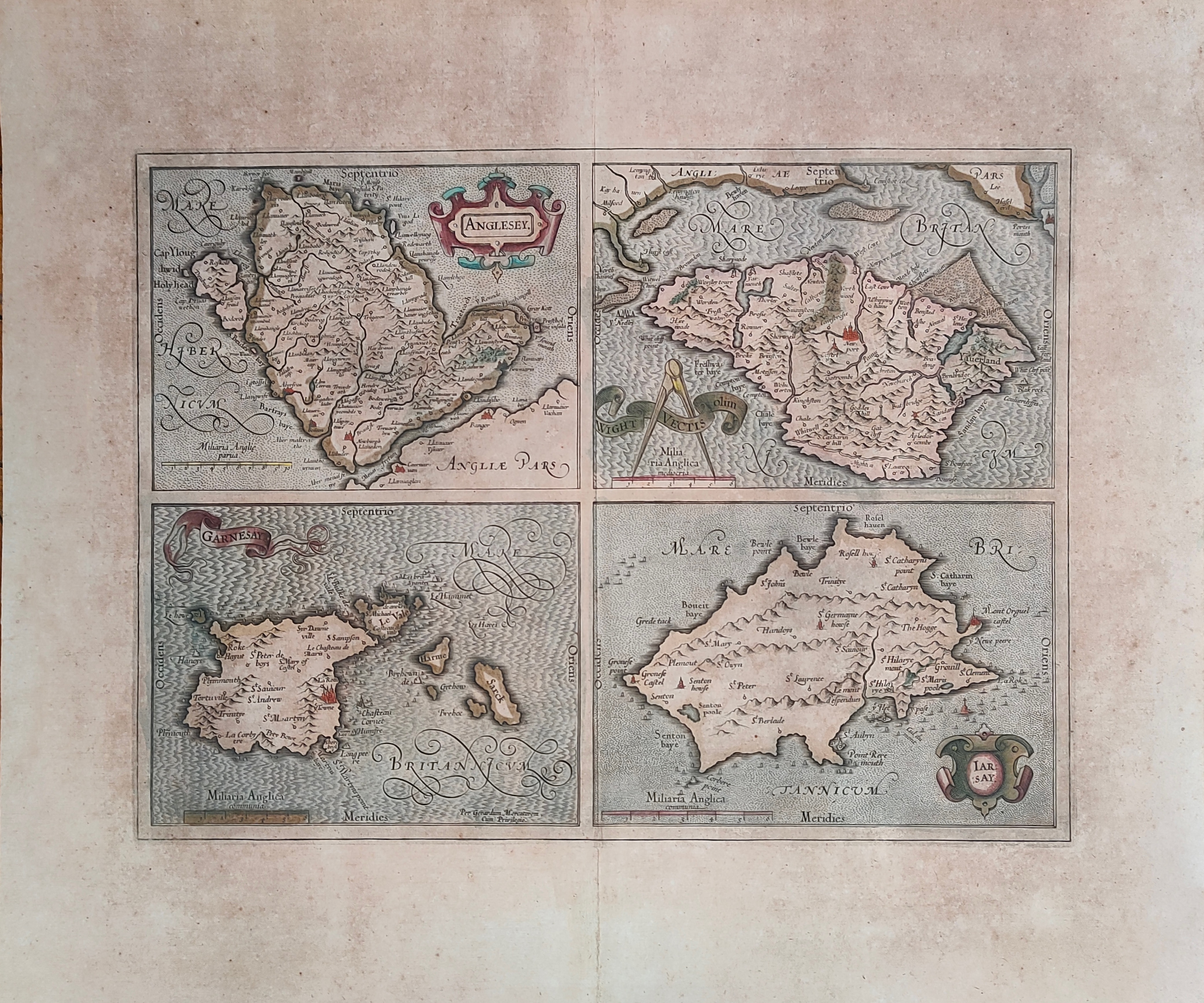
Map title
Anglesey, Garnesay, Wight olim Vectis, Iarsay
Author
Mercator
Location shown in map
Wight
Edition date
Circa 1628
Edition place
Amsterdam
Editor
Houndius
Atlas
Mercator-Hondius Atlas.
Price
250 Euro
State
[mint/EXCELLENT/very good/good/fair/mediocre/poor]
Color
Old colors
Verso
Latin text
Size
Plate: cm (42 x 32) inches (16.54 x 12.6) Paper: cm (55 x 47) inches (21.65 x 18.5)
Technique
Copper engraving
Note
Professionally repaired
Reference
Wiki
Here for more info
In stock
Available
Info
info@thetreasuremaps.com
Code
#1232
×
![]()
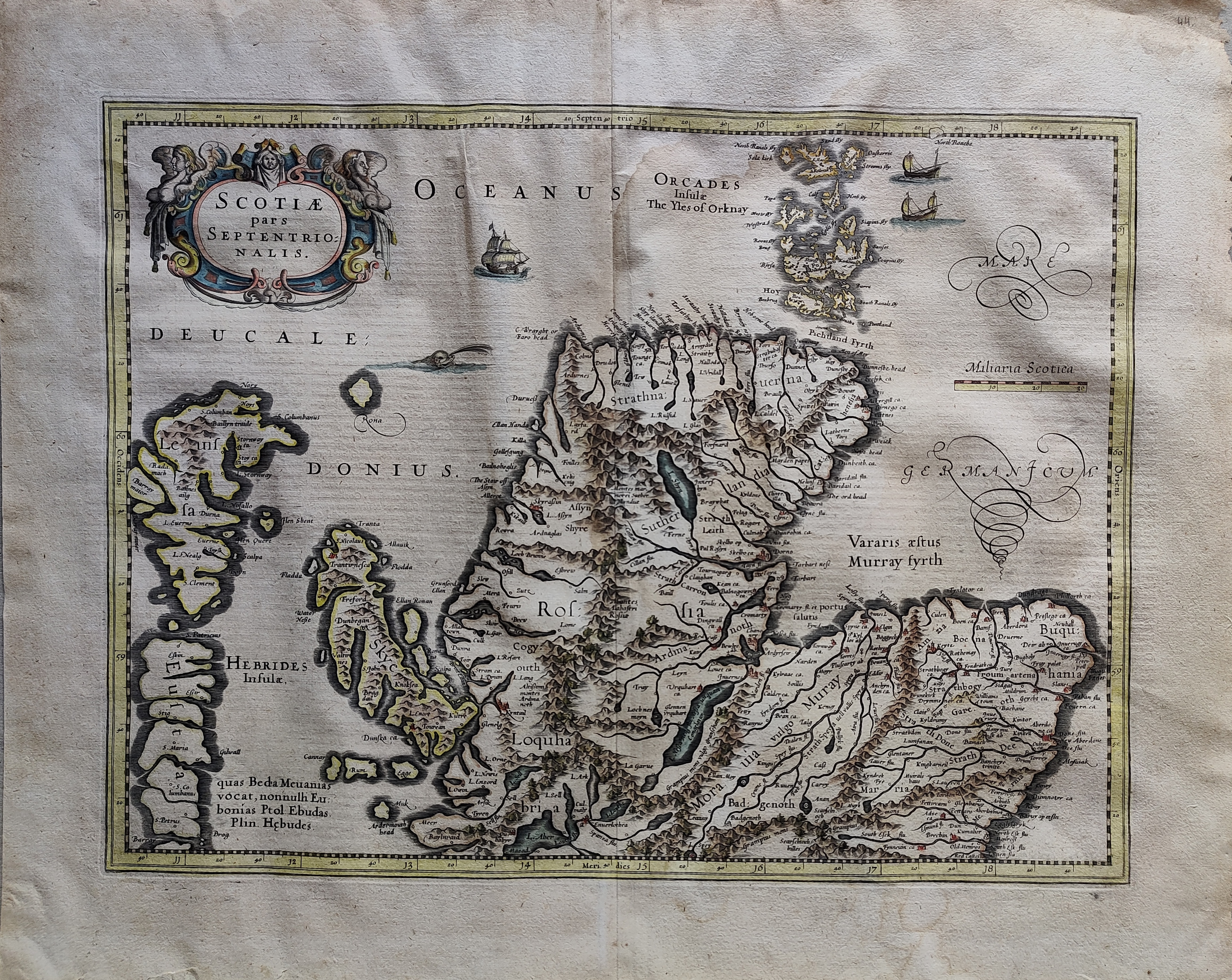
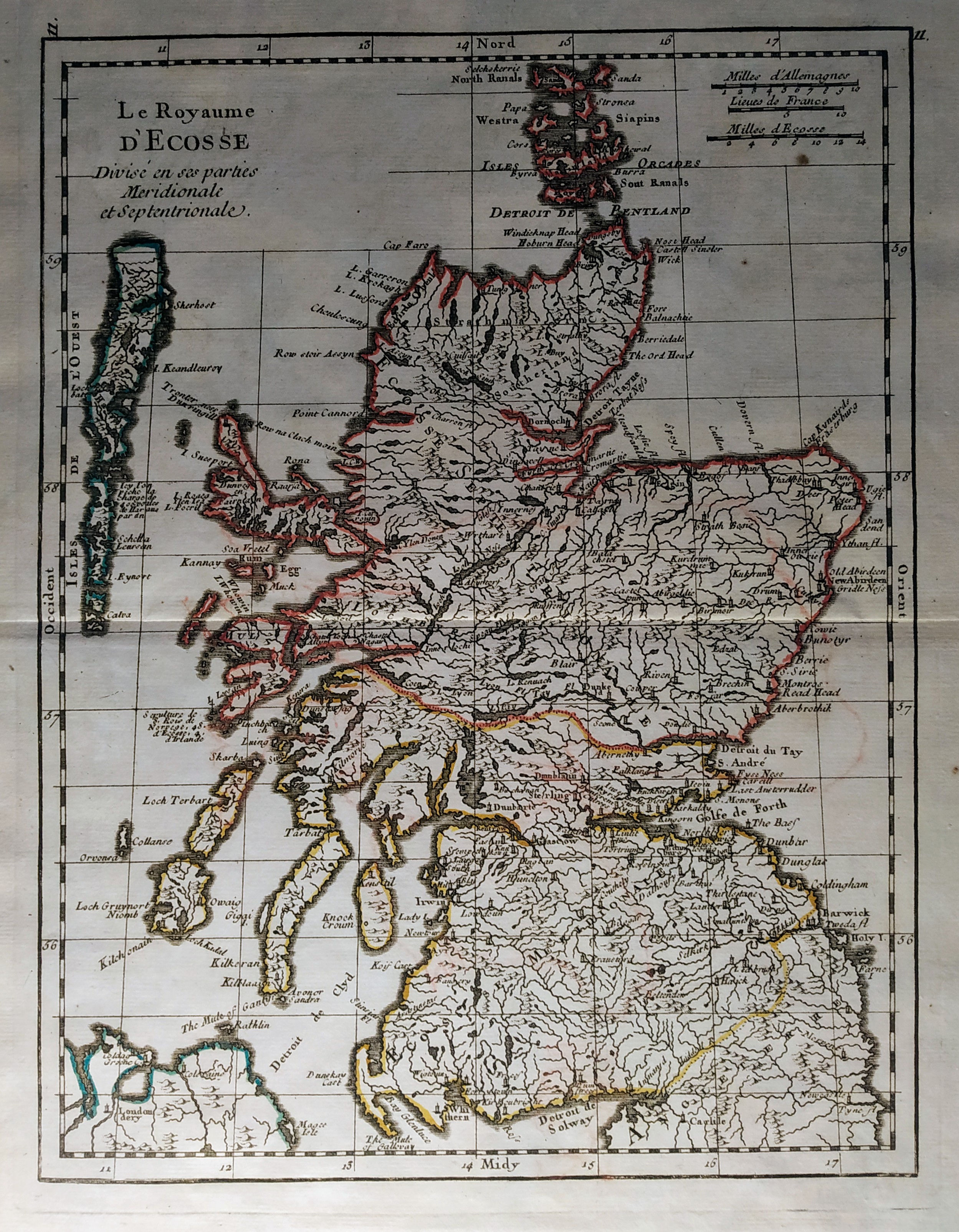
Map title
Scotiae pars septentrionalis
Author
Hondius
Location shown in map
Scotland
Edition date
1638
Edition place
Amsterdam
Editor
Atlas
Price
400 Euro
State
[mint/EXCELLENT/very good/good/fair/mediocre/poor]
Color
Old colors
Verso
Latin text
Size
Plate: cm (45 x 35) inches (17.72 x 13.78) Paper: cm (55 x 46) inches (21.65 x 18.11)
Technique
Copper engraving
Note
Reference
Wiki
Here for more info
In stock
Available
Info
info@thetreasuremaps.com
Code
#1073
×
![]()
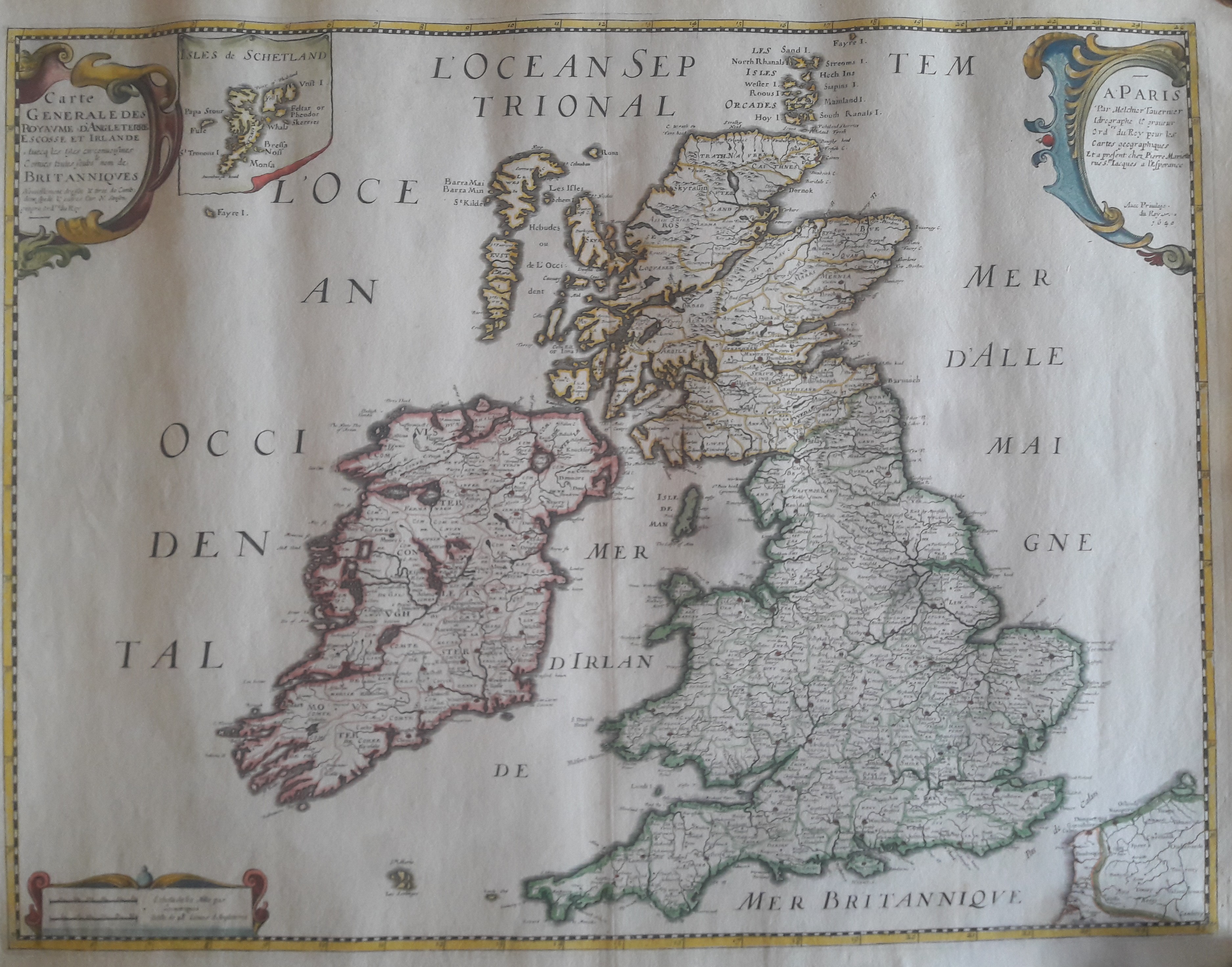
Map title
Carte generale des royaume d'Angleterre
Author
Sanson
Location shown in map
British Isles
Edition date
1640
Edition place
Paris
Editor
Melchior Tavenier
Atlas
Price
Please ask: info@thetreasuremaps.com
State
[mint/EXCELLENT/very good/good/fair/mediocre/poor]
Color
Old colors
Verso
Blank
Size
Plate: cm (52 x 39) inches (20.47 x 15.35) Paper: cm (57 x 44) inches (22.44 x 17.32)
Technique
Copper engraving
Note
No particular notes for this maps
Reference
Wiki
Here for more info
In stock
Available
Info
info@thetreasuremaps.com
Code
#0658
×
![]()
Map title
Carte generale des royaume d'Angleterre
Author
Sanson
Location shown in map
British Isles
Edition date
1658
Edition place
Paris
Editor
Melchior Tavenier
Atlas
Price
350 Euro
State
[mint/excellent/VERY GOOD/good/fair/mediocre/poor]
Color
Old colors
Verso
Blank
Size
Plate: cm (52 x 39) inches (20.47 x 15.35) Paper: cm (57 x 44) inches (22.44 x 17.32)
Technique
Copper engraving
Note
Reference
Wiki
Here for more info
In stock
Available
Info
info@thetreasuremaps.com
Code
#1173
×
![]()
Map title
De Fero de Scheland Orknay et Hebrides
Author
Mallet
Location shown in map
North of England
Edition date
1683
Edition place
Paris
Editor
--
Atlas
Description de l'univers - Chez Denis Thierry
Price
75 Euro
State
[mint/EXCELLENT/very good/good/fair/mediocre/poor] Only a small part of the map.
Color
Black/white
Verso
French text pag 24
Size
Plate: cm (10.2 x 15.2) inches (4.02 x 5.98) Paper: cm (12.7 x 20.3) inches (5 x 7.99)
Technique
Copper engraving
Note
No particular notes for this maps
Reference
--
Wiki
Here for more info
In stock
Available
Info
info@thetreasuremaps.com
Code
#0140
×
![]()
Map title
North-sea
Author
Keulen, Joannes
Location shown in map
British Isles
Edition date
1690
Edition place
Amsterdam
Editor
Atlas
Price
Please ask: info@thetreasuremaps.com
State
[mint/excellent/VERY GOOD/good/fair/mediocre/poor]
Color
Black/white
Verso
Blank
Size
Plate: cm (55 x 95) inches (21.65 x 37.4) Paper: cm (55 x 95) inches (21.65 x 37.4)
Technique
Copper engraving
Note
Professionally repaired
Reference
Wiki
Here for more info
In stock
Available
Info
info@thetreasuremaps.com
Code
#0740
×
![]()
Map title
Parte meridionale del regno d'Inghilterra
Author
Coronelli
Location shown in map
South England
Edition date
1696
Edition place
Venice
Editor
--
Atlas
Isolario dell'atlante veneto
Price
400 Euro
State
[mint/EXCELLENT/very good/good/fair/mediocre/poor]
Color
Old colors
Verso
Italian text pag.4
Size
Plate: cm (62 x 46) inches (24.41 x 18.11) Paper: cm (64 x 47) inches (25.2 x 18.5)
Technique
Copper engraving
Note
Reference
--
Wiki
Here for more info
In stock
Available
Info
info@thetreasuremaps.com
Code
#1020
×
![]()
Map title
Scotia parte settentrionale
Author
Coronelli
Location shown in map
North Scotland
Edition date
1696
Edition place
Venice
Editor
--
Atlas
Isolario dell'atlante veneto
Price
400 Euro
State
[mint/EXCELLENT/very good/good/fair/mediocre/poor]
Color
Old colors
Verso
Italian tesx pag.22
Size
Plate: cm (62 x 46) inches (24.41 x 18.11) Paper: cm (64 x 47) inches (25.2 x 18.5)
Technique
Copper engraving
Note
Reference
--
Wiki
Here for more info
In stock
Available
Info
info@thetreasuremaps.com
Code
#1021
×
![]()
Map title
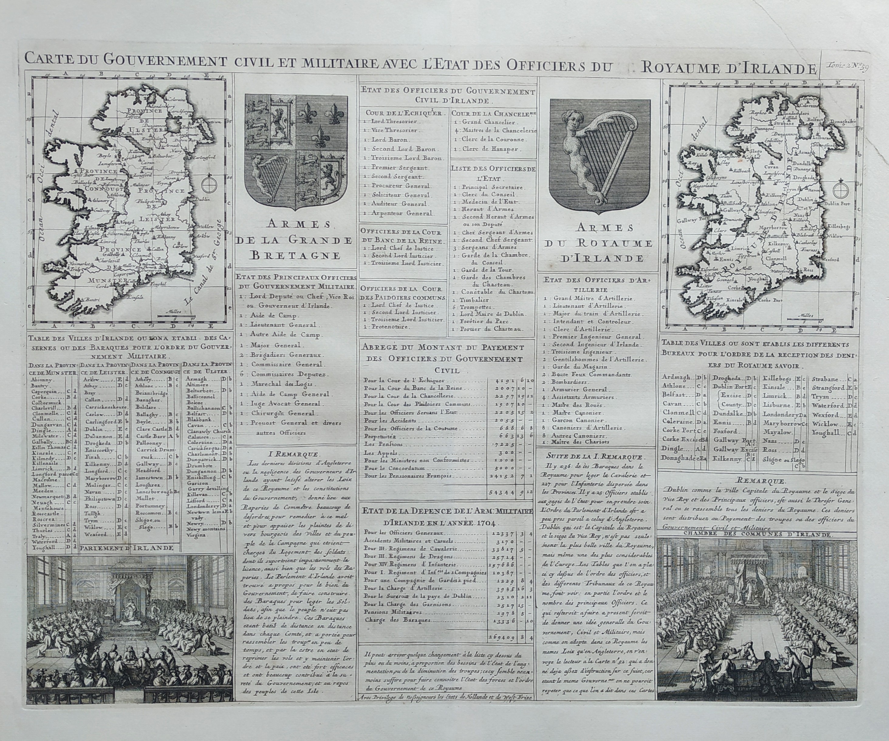
Carte du government civil et miltaire avec l'etat des officiers du royaume d'Irlande
Author
Henri Chatelain
Location shown in map
Irland
Edition date
1719
Edition place
Amsterdam
Editor
Atlas
Atlas Historique
Price
Please ask: info@thetreasuremaps.com
State
[mint/EXCELLENT/very good/good/fair/mediocre/poor]
Color
Black/white
Verso
Blank
Size
Plate: cm (52 x 42) inches (20.47 x 16.54) Paper: cm (53 x 43) inches (20.87 x 16.93)
Technique
Copper engraving
Note
Reference
Wiki
Here for more info
In stock
Available
Info
info@thetreasuremaps.com
Code
#0825
×
![]()
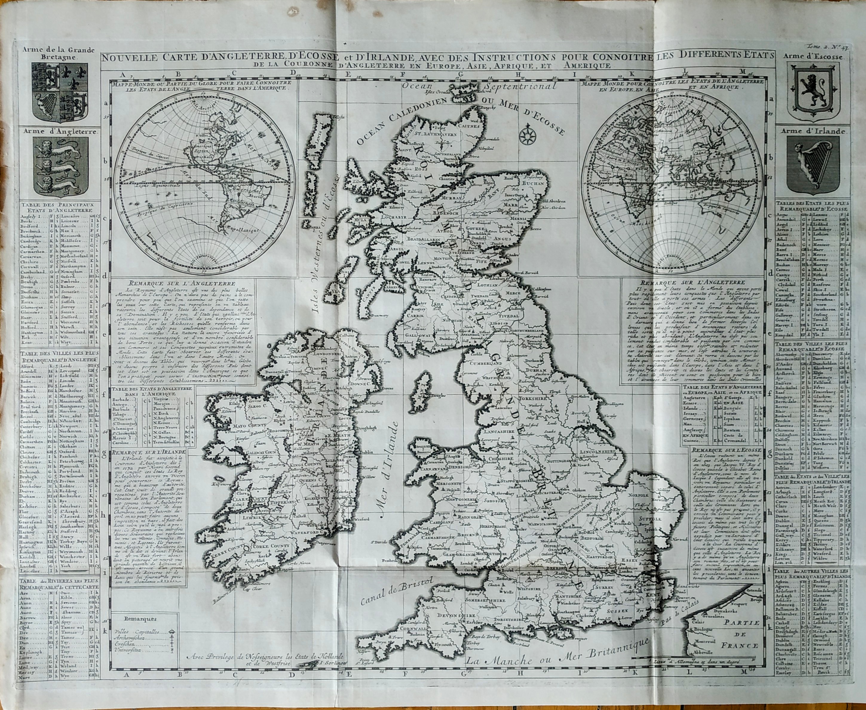
Map title
Nouvelle carte d'Angleterre d'Ecosse et d'Irlande
Author
Henri Chatelain
Location shown in map
Great Britain
Edition date
1719
Edition place
Amsterdam
Editor
Atlas
Atlas Historique
Price
350 Euro
State
[mint/EXCELLENT/very good/good/fair/mediocre/poor]
Color
Black/white
Verso
Blank
Size
Plate: cm (62 x 47) inches (24.41 x 18.5) Paper: cm (65 x 53) inches (25.59 x 20.87)
Technique
Copper engraving
Note
Reference
Wiki
Here for more info
In stock
Available
Info
info@thetreasuremaps.com
Code
#0813
×
![]()
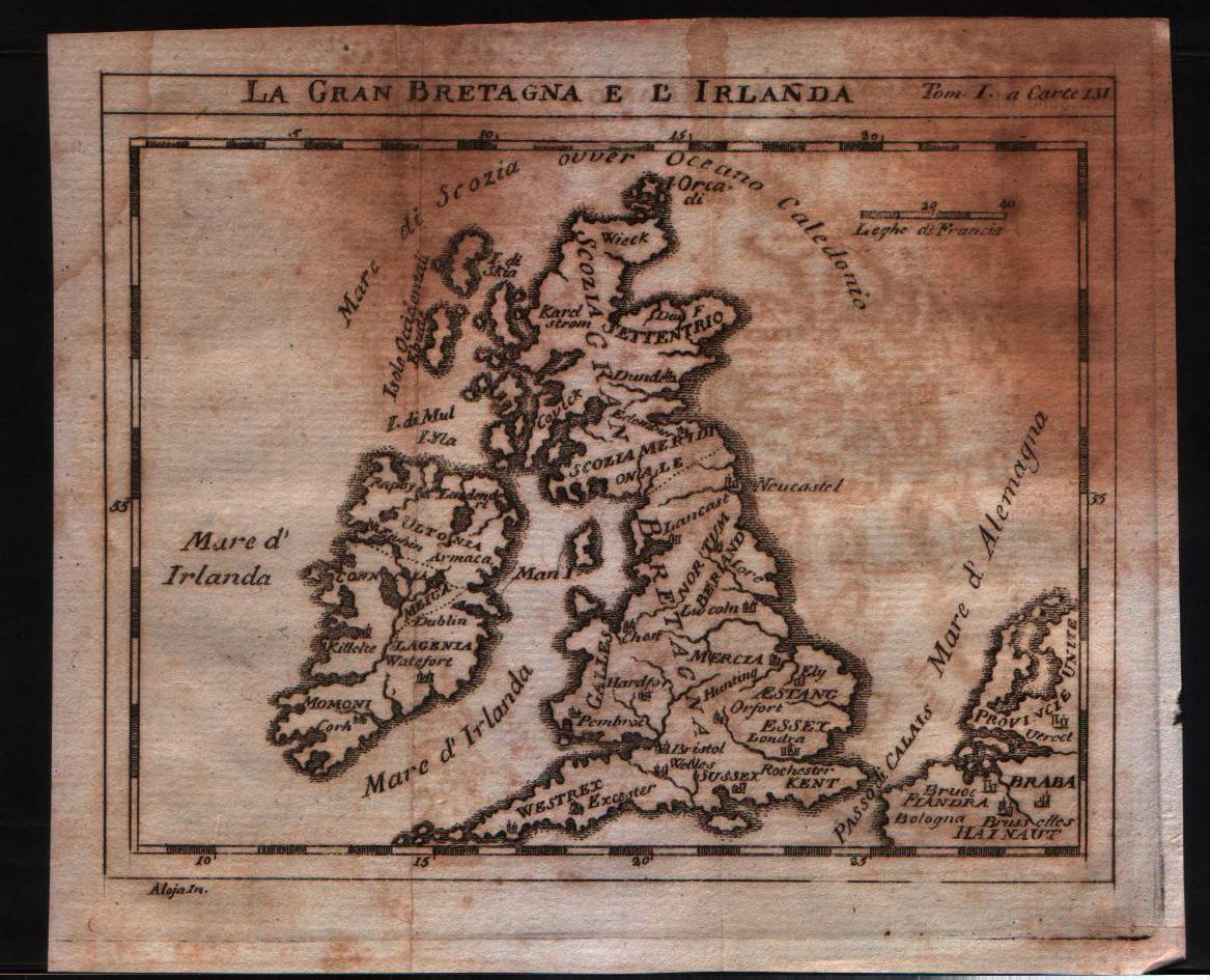
Map title
La Gran Bretagna e l'Irlanda
Author
Unknown
Location shown in map
British Isles
Edition date
1730
Edition place
???
Editor
--
Atlas
--
Price
125 Euro
State
[mint/excellent/VERY GOOD/good/fair/mediocre/poor]
Color
Black/white
Verso
Blank
Size
Plate: cm (15.2 x 12.7) inches (5.98 x 5) Paper: cm (18.4 x 15.9) inches (7.24 x 6.26)
Technique
Copper engraving
Note
No particular notes for this maps
Reference
--
Wiki
Here for more info
In stock
Available
Info
info@thetreasuremaps.com
Code
#0145
×
![]()
Map title
Le Royaume D'Ecosse
Author
Le Rouge
Location shown in map
Scotland
Edition date
1748
Edition place
Paris
Editor
--
Atlas
Atlas Nouveau Portatif l'usage des militaries et du voyageur
Price
125 Euro
State
[mint/EXCELLENT/very good/good/fair/mediocre/poor]
Color
Old outlined
Verso
Blank
Size
Plate: cm (20.3 x 27.3) inches (7.99 x 10.75) Paper: cm (20.3 x 27.3) inches (7.99 x 10.75)
Technique
Copper engraving
Note
No particular notes for this maps
Reference
--
Wiki
Here for more info
In stock
Available
Info
info@thetreasuremaps.com
Code
#0157
×
![]()
Map title
L'Angleterre
Author
Le Rouge
Location shown in map
England
Edition date
1748
Edition place
Paris
Editor
--
Atlas
Atlas Nouveau Portatif l'usage des militaries et du voyageur
Price
125 Euro
State
[mint/EXCELLENT/very good/good/fair/mediocre/poor]
Color
Old outlined
Verso
Blank
Size
Plate: cm (20.3 x 27.3) inches (7.99 x 10.75) Paper: cm (20.3 x 27.3) inches (7.99 x 10.75)
Technique
Copper engraving
Note
No particular notes for this maps
Reference
--
Wiki
Here for more info
In stock
Available
Info
info@thetreasuremaps.com
Code
#0156
×
![]()
Map title
Le royaume d'Angleterre
Author
Robert de Vaugondy
Location shown in map
British Isles
Edition date
1753
Edition place
Paris
Editor
Delamarche
Atlas
Atlas Universel
Price
200 Euro
State
[mint/excellent/VERY GOOD/good/fair/mediocre/poor]
Color
Old color
Verso
Blank
Size
Plate: cm (66 x 51) inches (25.98 x 20.08) Paper: cm (53 x 49) inches (20.87 x 19.29)
Technique
Copper engraving
Note
No particular notes for this maps.
Reference
--
Wiki
Here for more info
In stock
Available
Info
info@thetreasuremaps.com
Code
#0759
×
![]()
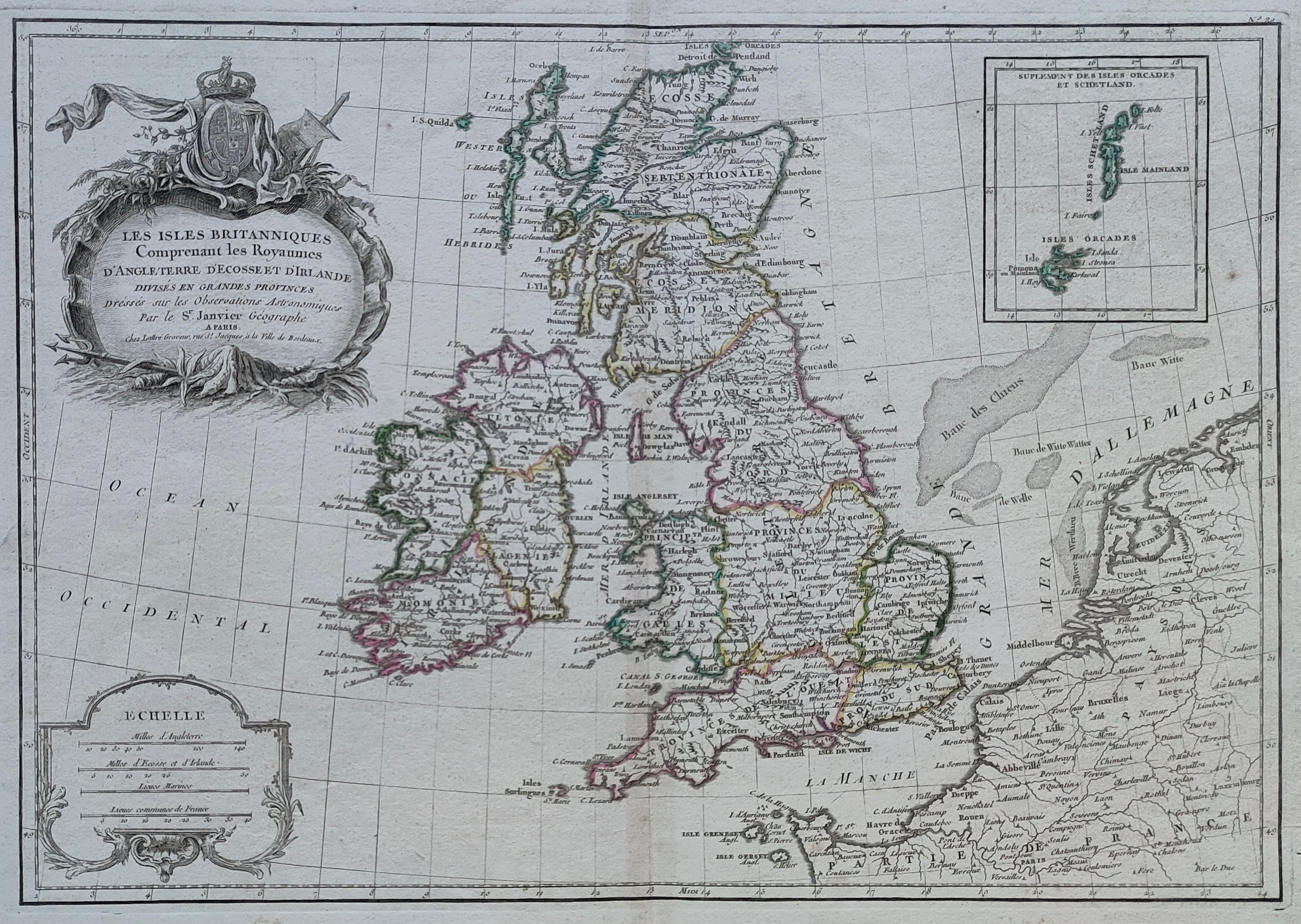
Map title
Les Isles Britanniques qui comprennent les Royaumes d'Angleterre, d'Ecosse et d'Irlande.
Author
Robert de Vaugondy
Location shown in map
British Isles
Edition date
1754
Edition place
Paris
Editor
Atlas
Atlas Universel
Price
200 Euro
State
[mint/EXCELLENT/very good/good/fair/mediocre/poor]
Color
Old colors
Verso
Blank
Size
Plate: cm (58 x 48) inches (22.83 x 18.9) Paper: cm (73 x 55) inches (28.74 x 21.65)
Technique
Copper engraving
Note
Reference
Wiki
Here for more info
In stock
Available
Info
info@thetreasuremaps.com
Code
#1072
×
![]()
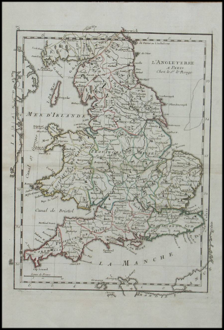
Map title
Les isles Britanniques
Author
Philippe
Location shown in map
British Isles
Edition date
1767
Edition place
Paris
Editor
Atlas
Price
125 Euro
State
[mint/EXCELLENT/very good/good/fair/mediocre/poor]
Color
Black/white
Verso
Blank
Size
Plate: cm (40 x 27) inches (15.75 x 10.63) Paper: cm (44 x 31) inches (17.32 x 12.2)
Technique
Copper engraving
Note
Reference
Wiki
Here for more info
In stock
Available
Info
info@thetreasuremaps.com
Code
#1215
×
![]()
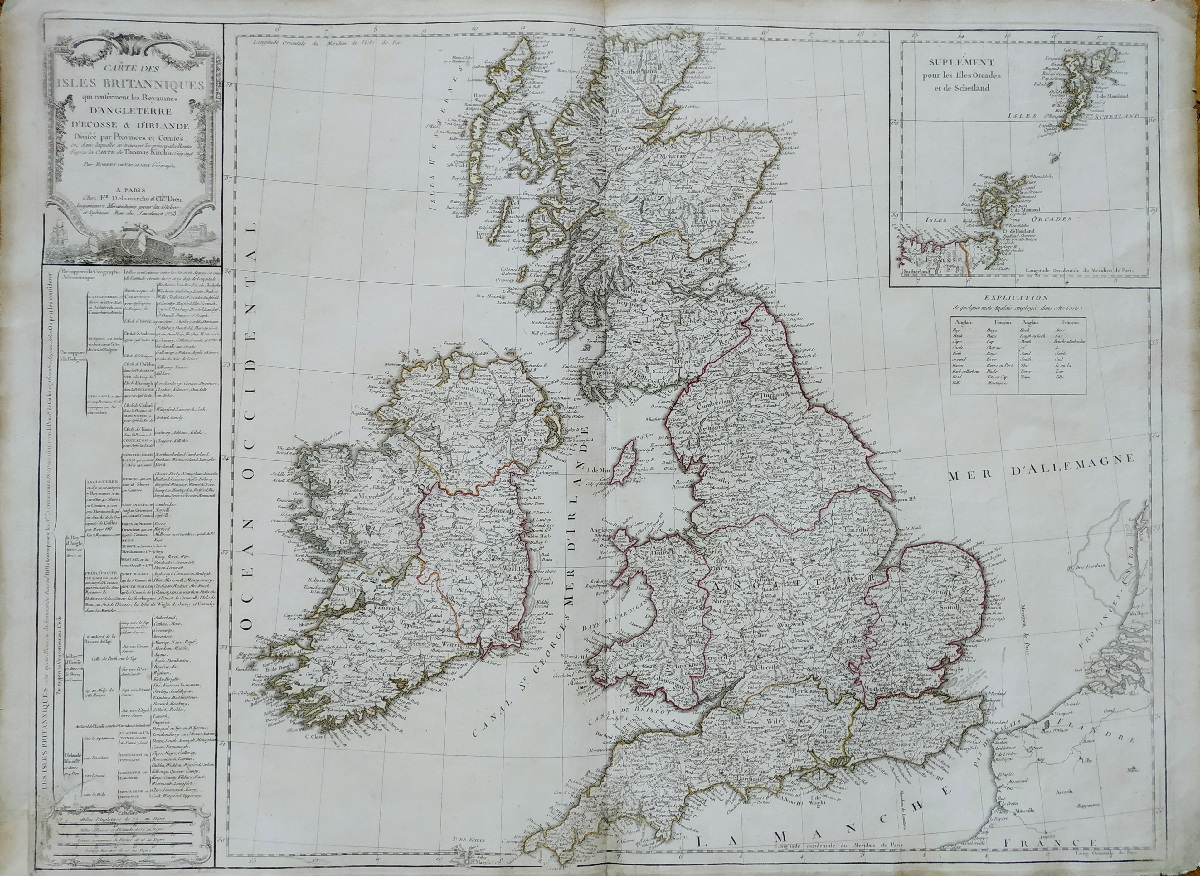
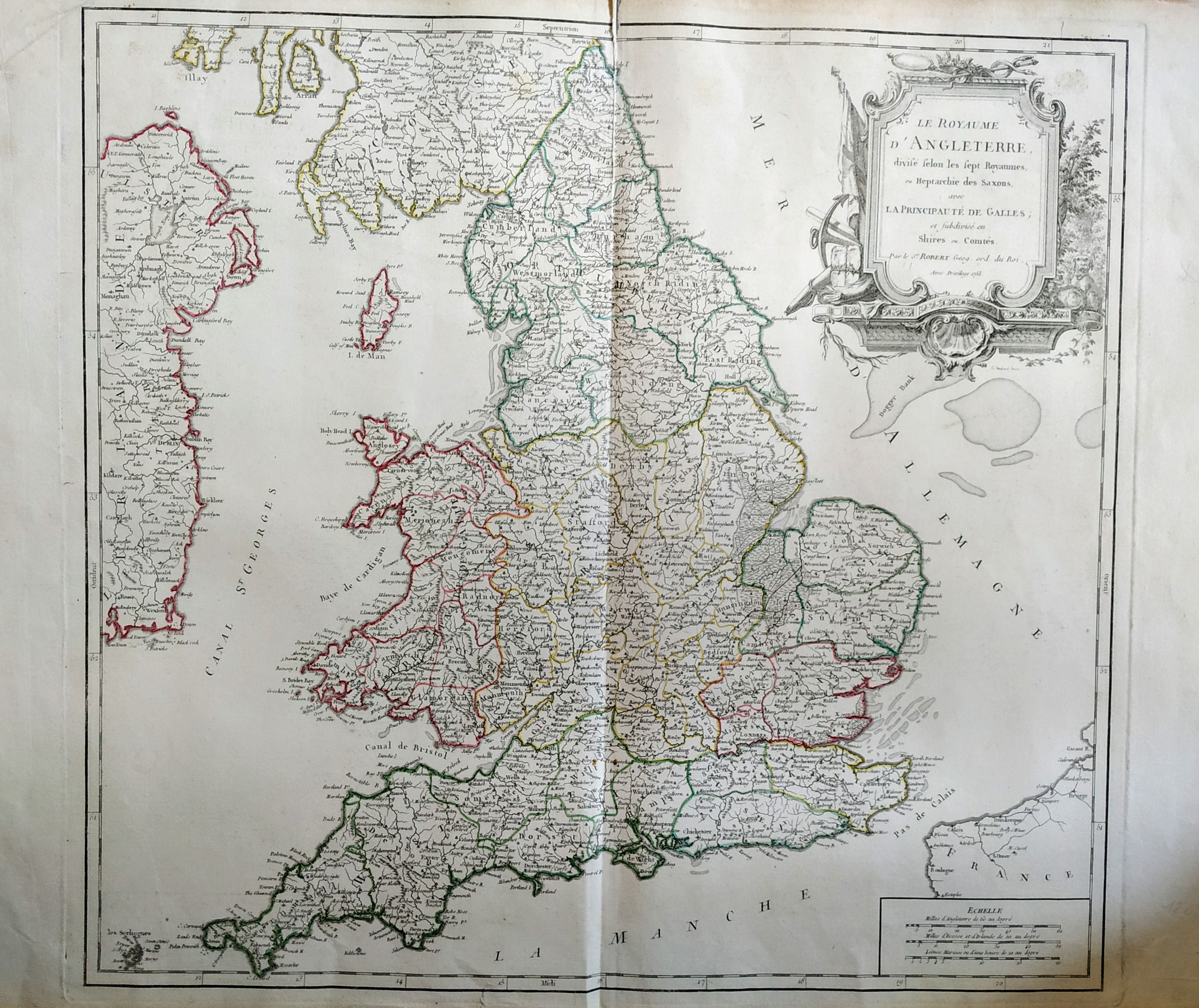
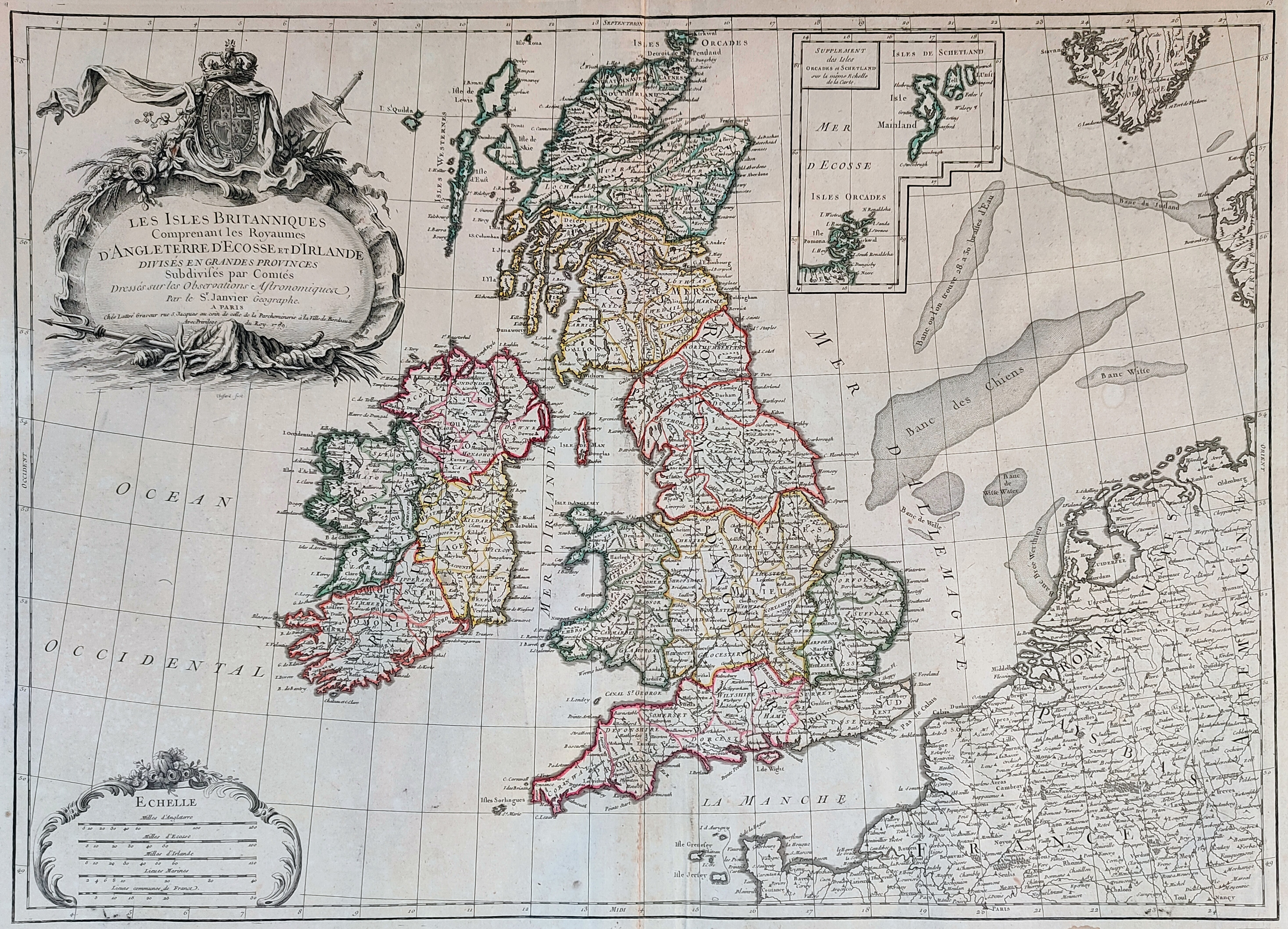
Map title
Cartes des isles Britanniques
Author
Robert de Vaugondy
Location shown in map
British Isles
Edition date
Circa 1780
Edition place
Paris
Editor
Delamarche
Atlas
Atlas d Etude pour l'instruction de la Jeunesse
Price
Please ask: info@thetreasuremaps.com
State
[mint/excellent/VERY GOOD/good/fair/mediocre/poor]
Color
Old color
Verso
Blank
Size
Plate: cm (71 x 53) inches (27.95 x 20.87) Paper: cm (77 x 57) inches (30.31 x 22.44)
Technique
Copper engraving
Note
Professionally rapaired
Reference
--
Wiki
Here for more info
In stock
Available
Info
info@thetreasuremaps.com
Code
#0744
×
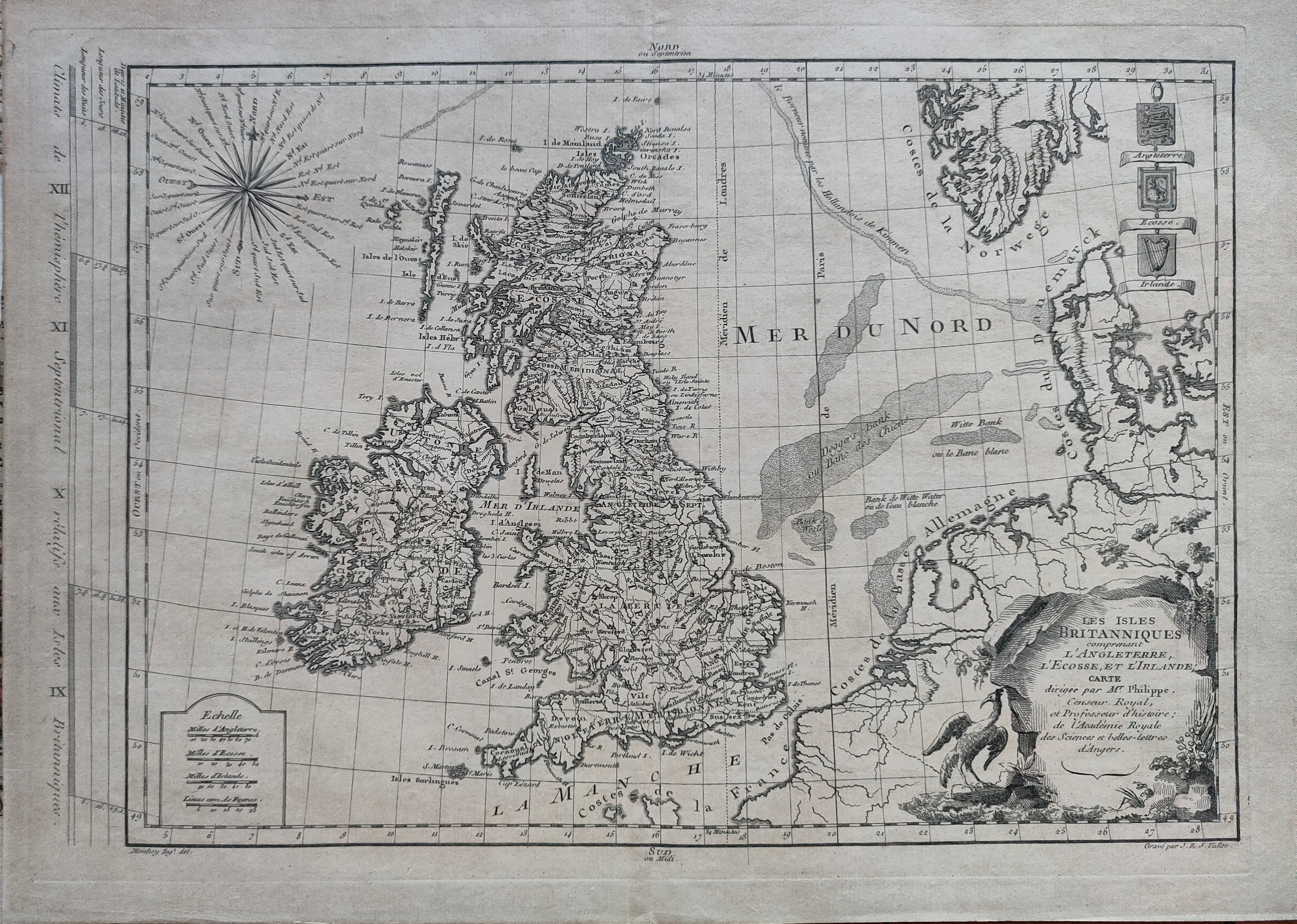
![]()
Map title
Les isles Britanniques
Author
Janvier
Location shown in map
British Isles
Edition date
Circa 1782
Edition place
Paris
Editor
Atlas
Price
150 Euro
State
[mint/EXCELLENT/very good/good/fair/mediocre/poor]
Color
Old colors
Verso
Blank
Size
Plate: cm (44 x 31) inches (17.32 x 12.2) Paper: cm (50 x 37) inches (19.69 x 14.57)
Technique
Copper engraving
Note
Reference
Wiki
Here for more info
In stock
Available
Info
info@thetreasuremaps.com
Code
#1216
×
![]()
Map title
Les Iles Britanniques comprenant les Royaumes d'Angleterre ...
Author
Janvier
Location shown in map
England
Edition date
1784
Edition place
Venice
Editor
Atlas
Atlas Universel, dresse sur les meilleures cartes modernes
Price
250 Euro
State
[mint/EXCELLENT/very good/good/fair/mediocre/poor]
Color
Old colors
Verso
Blank
Size
Plate: cm (73 x 54) inches (28.74 x 21.26) Paper: cm (65 x 47) inches (25.59 x 18.5)
Technique
Copper engraving
Note
Reference
Wiki
Here for more info
In stock
Available
Info
info@thetreasuremaps.com
Code
#0920
×
![]()
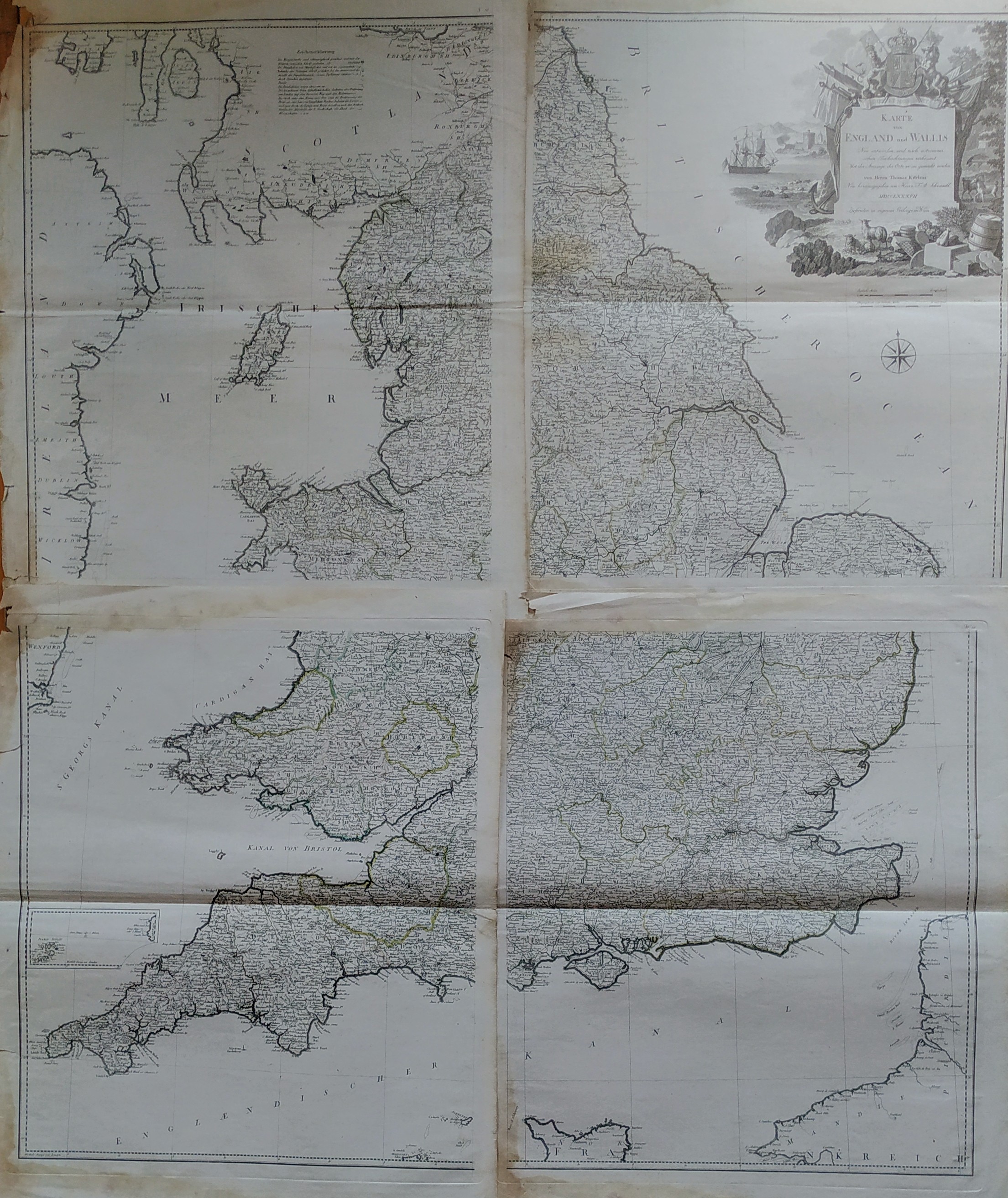
Map title
Karte von England und Wallis
Author
Thomas Kitchin
Location shown in map
England
Edition date
1787
Edition place
Wien
Editor
Atlas
Price
350 Euro
State
[mint/EXCELLENT/very good/good/fair/mediocre/poor]
Color
Black/white
Verso
Blank
Size
Plate: cm (0 x 0) inches (0 x 0) Paper: cm (0 x 0) inches (0 x 0)
Technique
Copper engraving
Note
Reference
Wiki
Here for more info
In stock
Available
Info
info@thetreasuremaps.com
Code
#0826
×
![]()
Map title
Scozia
Author
Unknown
Location shown in map
Scotland
Edition date
1820
Edition place
Milan
Editor
--
Atlas
Atlante Nuovo di Batelli & Fanfani
Price
125 Euro
State
[mint/EXCELLENT/very good/good/fair/mediocre/poor]
Color
Old outlined
Verso
Blank
Size
Plate: cm (21.6 x 17.8) inches (8.5 x 7.01) Paper: cm (21.6 x 17.8) inches (8.5 x 7.01)
Technique
--
Note
No particular notes for this maps
Reference
--
Wiki
Here for more info
In stock
Sold
Info
info@thetreasuremaps.com
Code
#0491
×
![]()
Map title
Iles Britannique
Author
Monin
Location shown in map
British Isles
Edition date
1840
Edition place
Paris
Editor
Atlas
Atlas Classique de la Geographie
Price
75 Euro
State
[mint/EXCELLENT/very good/good/fair/mediocre/poor]
Color
Old colors
Verso
Blank
Size
Plate: cm (28 x 37) inches (11.02 x 14.57) Paper: cm (33 x 45) inches (12.99 x 17.72)
Technique
Copper engraving
Note
Reference
Wiki
Here for more info
In stock
Available
Info
info@thetreasuremaps.com
Code
#1010
×
![]()
Map title
London
Author
Benjamin Rees Davies
Location shown in map
London
Edition date
1843
Edition place
London
Editor
S.D.U.K.
Atlas
Price
250 Euro
State
[mint/EXCELLENT/very good/good/fair/mediocre/poor]
Color
Old color
Verso
Blank
Size
Plate: cm (65 x 39) inches (25.59 x 15.35) Paper: cm (67 x 40) inches (26.38 x 15.75)
Technique
Steel engraving
Note
No particular notes for this maps.
Reference
Wiki
Here for more info
In stock
Sold
Info
info@thetreasuremaps.com
Code
#0743
London
Author
Benjamin Rees Davies
Location shown in map
London
Edition date
1843
Edition place
London
Editor
S.D.U.K.
Atlas
Price
250 Euro
State
[mint/EXCELLENT/very good/good/fair/mediocre/poor]
Color
Old color
Verso
Blank
Size
Plate: cm (65 x 39) inches (25.59 x 15.35) Paper: cm (67 x 40) inches (26.38 x 15.75)
Technique
Steel engraving
Note
No particular notes for this maps.
Reference
Wiki
Here for more info
In stock
Sold
Info
info@thetreasuremaps.com
Code
#0743
×
![]()
Map title
England
Author
Unknown
Location shown in map
--
Edition date
Unknown
Edition place
???
Editor
--
Atlas
--
Price
Please ask: info@thetreasuremaps.com
State
[mint/excellent/very good/good/fair/mediocre/POOR]
Color
Old outlined
Verso
Blank
Size
Plate: cm (119.4 x 91.4) inches (47.01 x 35.98) Paper: cm (119.4 x 91.4) inches (47.01 x 35.98)
Technique
Copper engraving
Note
Very large wall map
Reference
--
Wiki
Here for more info
In stock
Sold
Info
info@thetreasuremaps.com
Code
#0142
×
![]()