Central Africa
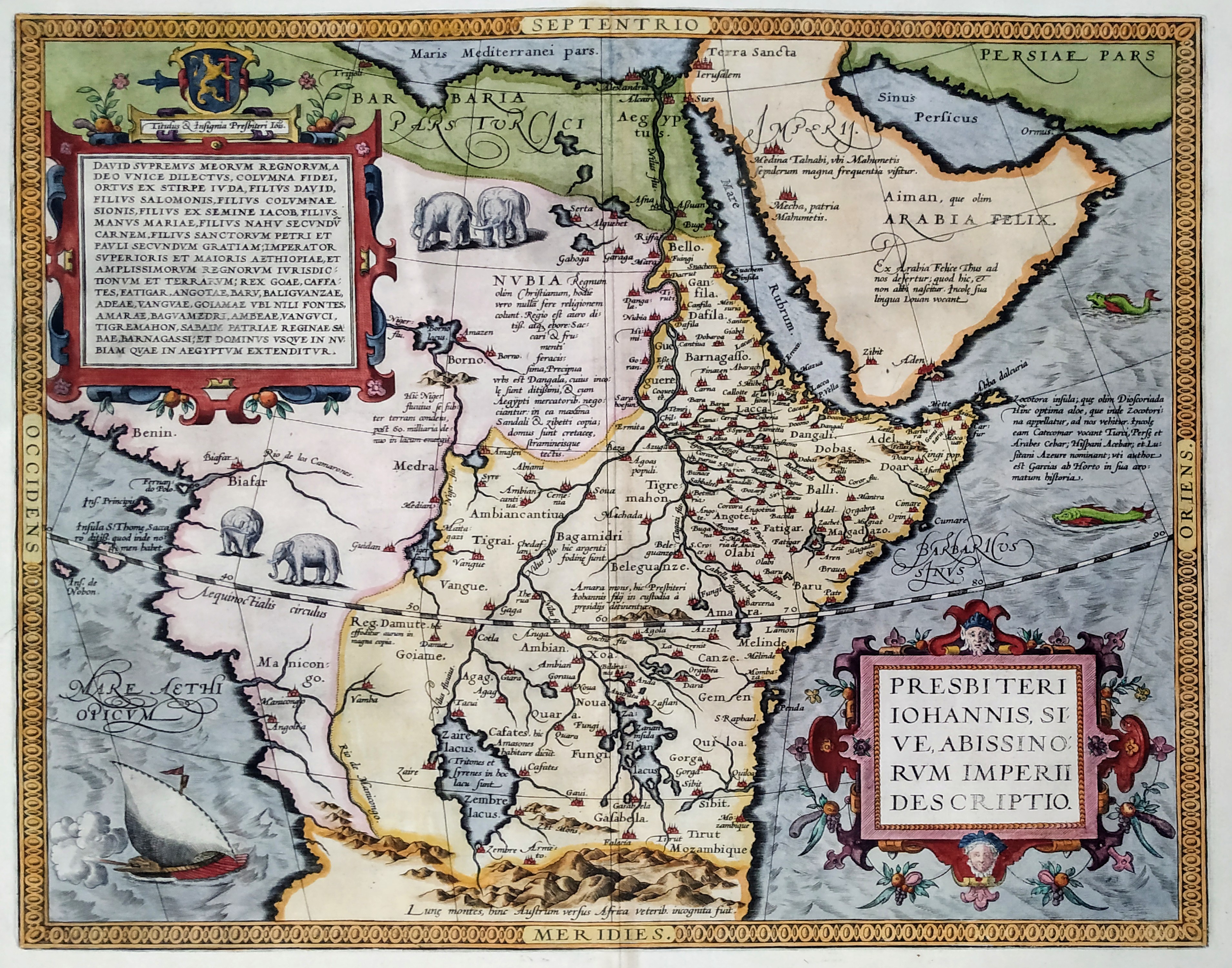
Map title
Presbiteri Johannis, Sive, Abissinorum Imperii Descriptio
Mapmakers
Ortelius
LocationLocation shown in map
Central Africa
Edition date
1592
Edition place
Anvers
Editor
--
Atlas
Theatrum Orbis Terrarum
Price
1000 Euro
State
[mint/EXCELLENT/very good/good/fair/mediocre/poor]
Color
Modern/Old color
Verso
Latin text
Size
Plate: cm (44 x 37) inches (17.32 x 14.57) Paper: cm (58 x 46) inches (22.83 x 18.11)
Technique
Copper engraving
Note
No particular notes for this maps
Reference
Van den Broecke 175
Wiki
Here for more info
In stock
Available
Info
info@thetreasuremaps.com
Code
#0287
Presbiteri Johannis, Sive, Abissinorum Imperii Descriptio
Mapmakers
Ortelius
Central Africa
Edition date
1592
Edition place
Anvers
Editor
--
Atlas
Theatrum Orbis Terrarum
Price
1000 Euro
State
[mint/EXCELLENT/very good/good/fair/mediocre/poor]
Color
Modern/Old color
Verso
Latin text
Size
Plate: cm (44 x 37) inches (17.32 x 14.57) Paper: cm (58 x 46) inches (22.83 x 18.11)
Technique
Copper engraving
Note
No particular notes for this maps
Reference
Van den Broecke 175
Wiki
Here for more info
In stock
Available
Info
info@thetreasuremaps.com
Code
#0287
×
![]()
Map title
Abissinorum imperium
Mapmakers
Bertius
LocationLocation shown in map
Africa
Edition date
1600
Edition place
Amsterdam
Editor
--
Atlas
Tabularum geographicarum contractarum
Price
200 Euro
State
[mint/EXCELLENT/very good/good/fair/mediocre/poor]
Color
Black/white
Verso
Latin text
Size
Plate: cm (12 x 8) inches (4.72 x 3.15) Paper: cm (18 x 12) inches (7.09 x 4.72)
Technique
Copper engraving
Note
Reference
Wiki
Here for more info
In stock
Available
Info
info@thetreasuremaps.com
Code
#1182
Abissinorum imperium
Mapmakers
Bertius
Africa
Edition date
1600
Edition place
Amsterdam
Editor
--
Atlas
Tabularum geographicarum contractarum
Price
200 Euro
State
[mint/EXCELLENT/very good/good/fair/mediocre/poor]
Color
Black/white
Verso
Latin text
Size
Plate: cm (12 x 8) inches (4.72 x 3.15) Paper: cm (18 x 12) inches (7.09 x 4.72)
Technique
Copper engraving
Note
Reference
Wiki
Here for more info
In stock
Available
Info
info@thetreasuremaps.com
Code
#1182
×
![]()
Map title
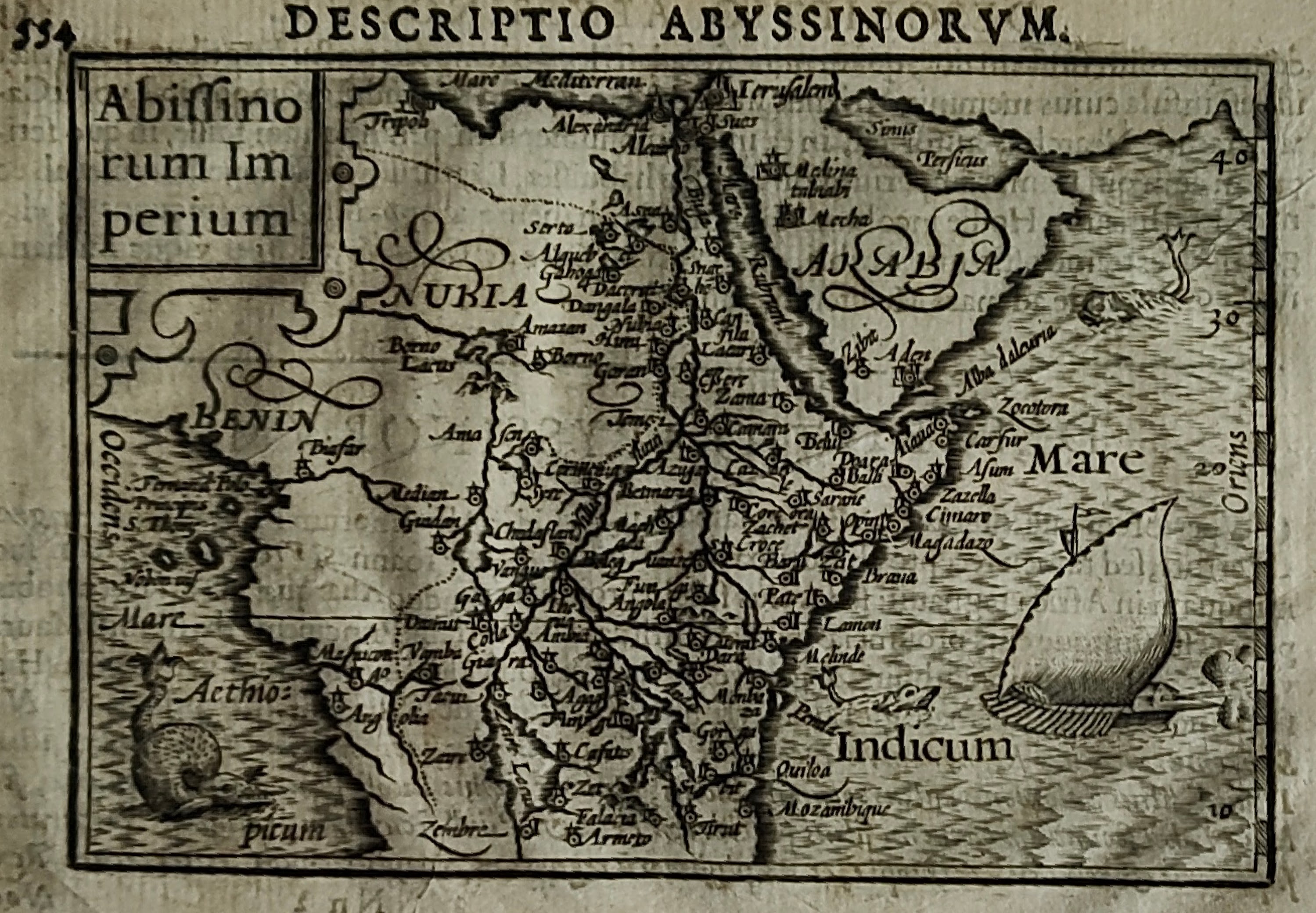
Abissinorum regnum
Mapmakers
Mercator
LocationLocation shown in map
East Africa
Edition date
1607
Edition place
Amsterdam
Editor
Janssonius
Atlas
Altas Minor Gerardi Mercatoris
Price
150 Euro
State
[mint/EXCELLENT/very good/good/fair/mediocre/poor]
Color
Black/white
Verso
Latin text pag.596
Size
Plate: cm (17.8 x 14) inches (7.01 x 5.51) Paper: cm (22.9 x 17.8) inches (9.02 x 7.01)
Technique
Copper engraving
Note
No particular notes for this maps
Reference
--
Wiki
Here for more info
In stock
Available
Info
info@thetreasuremaps.com
Code
#0291
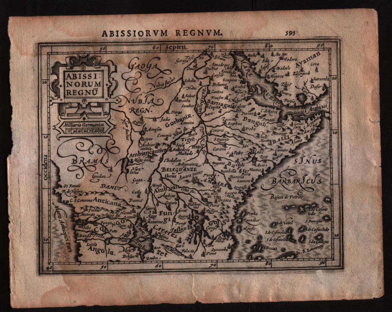
Abissinorum regnum
Mapmakers
Mercator
East Africa
Edition date
1607
Edition place
Amsterdam
Editor
Janssonius
Atlas
Altas Minor Gerardi Mercatoris
Price
150 Euro
State
[mint/EXCELLENT/very good/good/fair/mediocre/poor]
Color
Black/white
Verso
Latin text pag.596
Size
Plate: cm (17.8 x 14) inches (7.01 x 5.51) Paper: cm (22.9 x 17.8) inches (9.02 x 7.01)
Technique
Copper engraving
Note
No particular notes for this maps
Reference
--
Wiki
Here for more info
In stock
Available
Info
info@thetreasuremaps.com
Code
#0291
×
![]()
Map title
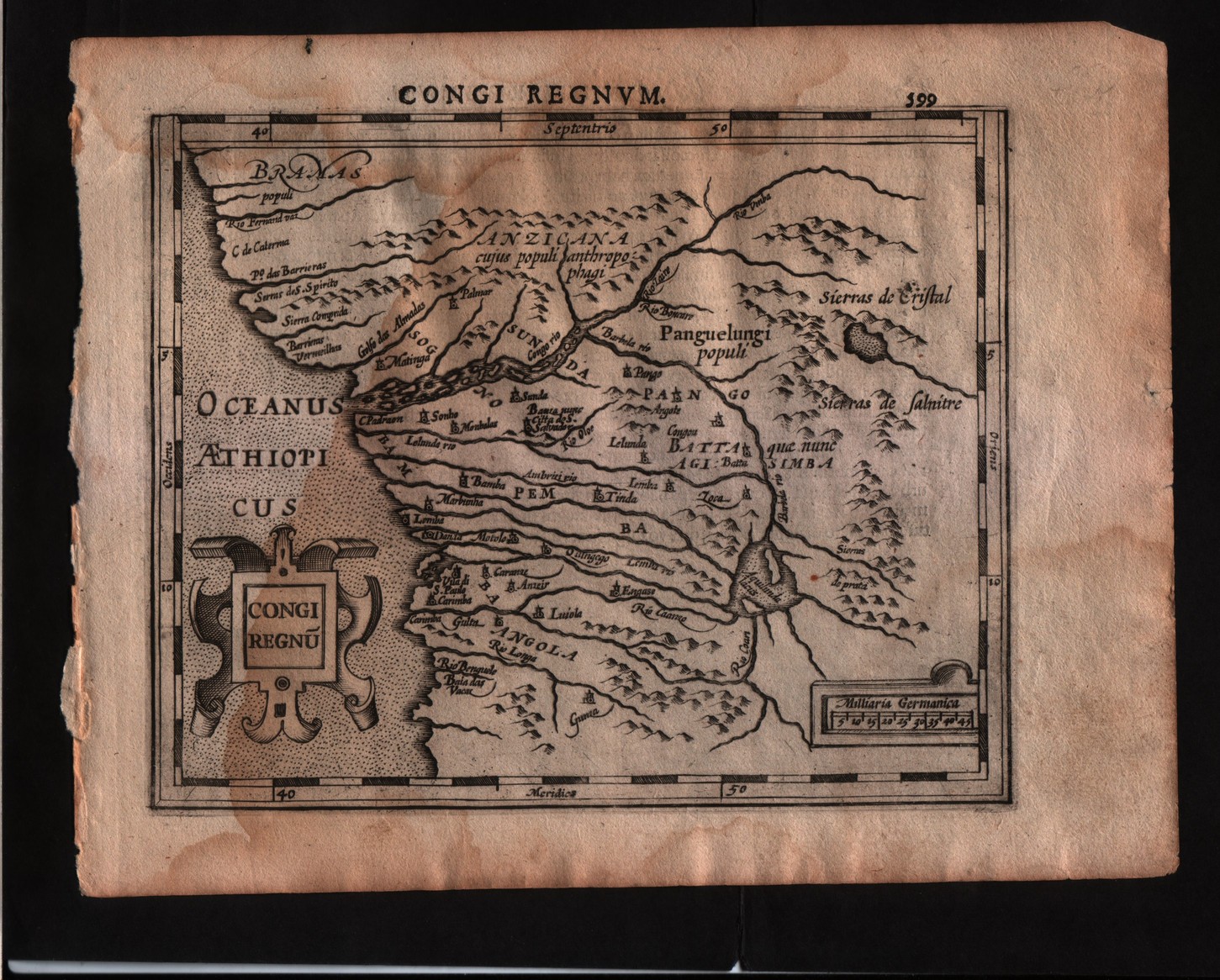
Congi regnum
Mapmakers
Mercator
LocationLocation shown in map
Congo
Edition date
1607
Edition place
Amsterdam
Editor
Janssonius
Atlas
Altas Minor Gerardi Mercatoris
Price
150 Euro
State
[mint/EXCELLENT/very good/good/fair/mediocre/poor]
Color
Black/white
Verso
Latin text pag.600
Size
Plate: cm (17.8 x 14) inches (7.01 x 5.51) Paper: cm (22.9 x 17.8) inches (9.02 x 7.01)
Technique
Copper engraving
Note
No particular notes for this maps
Reference
--
Wiki
Here for more info
In stock
Available
Info
info@thetreasuremaps.com
Code
#0292
Congi regnum
Mapmakers
Mercator
Congo
Edition date
1607
Edition place
Amsterdam
Editor
Janssonius
Atlas
Altas Minor Gerardi Mercatoris
Price
150 Euro
State
[mint/EXCELLENT/very good/good/fair/mediocre/poor]
Color
Black/white
Verso
Latin text pag.600
Size
Plate: cm (17.8 x 14) inches (7.01 x 5.51) Paper: cm (22.9 x 17.8) inches (9.02 x 7.01)
Technique
Copper engraving
Note
No particular notes for this maps
Reference
--
Wiki
Here for more info
In stock
Available
Info
info@thetreasuremaps.com
Code
#0292
×
![]()
Map title
Abissinorum regnum
Mapmakers
Mercator
LocationLocation shown in map
East Africa
Edition date
1625
Edition place
London
Editor
--
Atlas
Purchas his Pilgrimes
Price
250 Euro
State
[mint/EXCELLENT/very good/good/fair/mediocre/poor]
Color
Modern colors
Verso
English text
Size
Plate: cm (17.8 x 14) inches (7.01 x 5.51) Paper: cm (21.6 x 33) inches (8.5 x 12.99)
Technique
Copper engraving
Note
No particular notes for this maps
Reference
--
Wiki
Here for more info
In stock
Available
Info
info@thetreasuremaps.com
Code
#0293
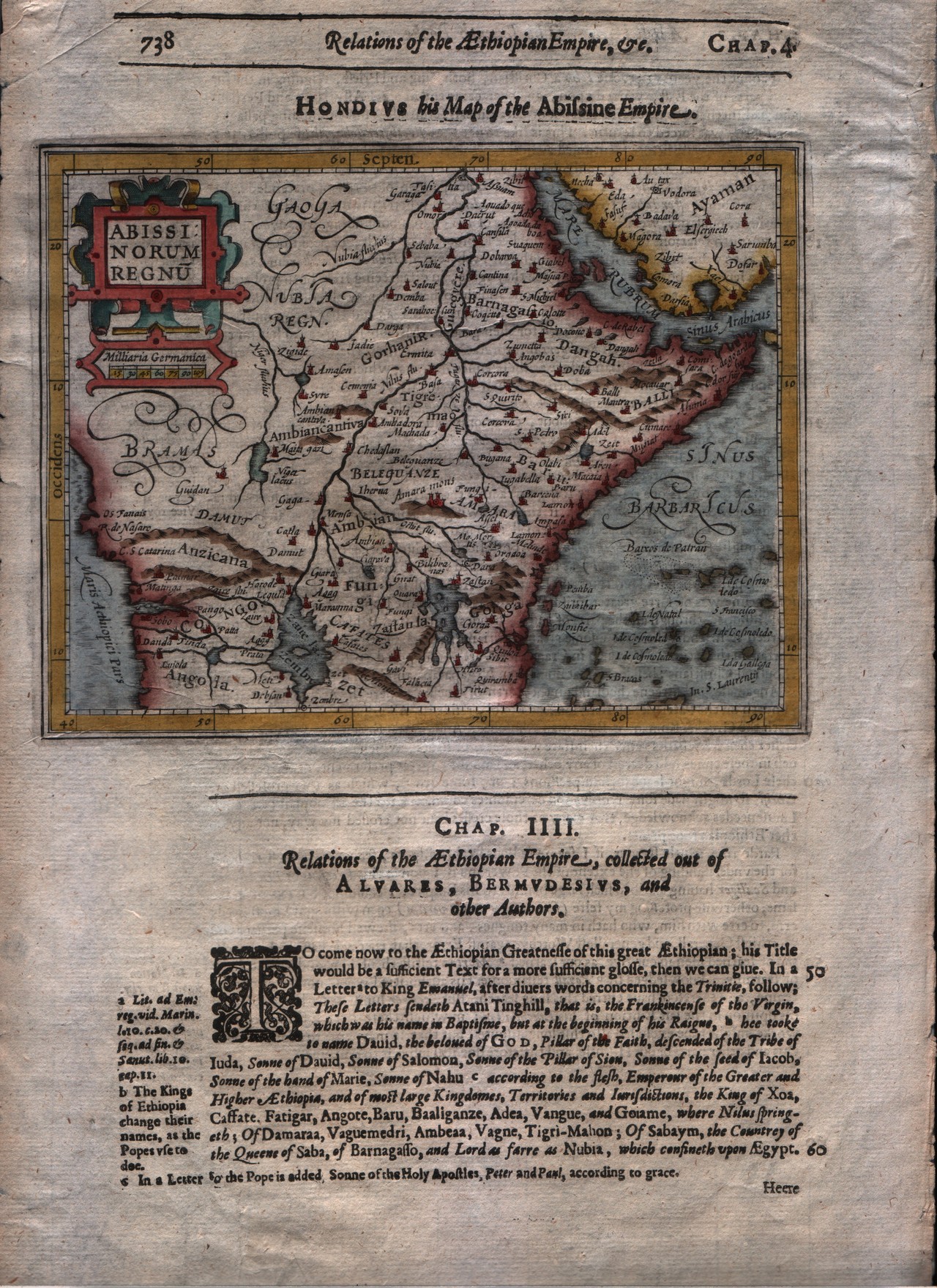
Abissinorum regnum
Mapmakers
Mercator
East Africa
Edition date
1625
Edition place
London
Editor
--
Atlas
Purchas his Pilgrimes
Price
250 Euro
State
[mint/EXCELLENT/very good/good/fair/mediocre/poor]
Color
Modern colors
Verso
English text
Size
Plate: cm (17.8 x 14) inches (7.01 x 5.51) Paper: cm (21.6 x 33) inches (8.5 x 12.99)
Technique
Copper engraving
Note
No particular notes for this maps
Reference
--
Wiki
Here for more info
In stock
Available
Info
info@thetreasuremaps.com
Code
#0293
×
![]()
Map title
Guinea
Mapmakers
Blaeu
LocationLocation shown in map
Gulf of Guinea
Edition date
1635
Edition place
Amsterdam
Editor
--
Atlas
Theatrum Orbis Terrarum, Sive Atlas Novis
Price
Please ask: info@thetreasuremaps.com
State
[mint/excellent/very good/GOOD/fair/mediocre/poor]
Color
Black/white
Verso
Franch text pag.4
Size
Plate: cm (53.3 x 38.1) inches (20.98 x 15) Paper: cm (61 x 50.8) inches (24.02 x 20)
Technique
Copper engraving
Note
No particular notes for this maps
Reference
--
Wiki
Here for more info
In stock
Available
Info
info@thetreasuremaps.com
Code
#0294
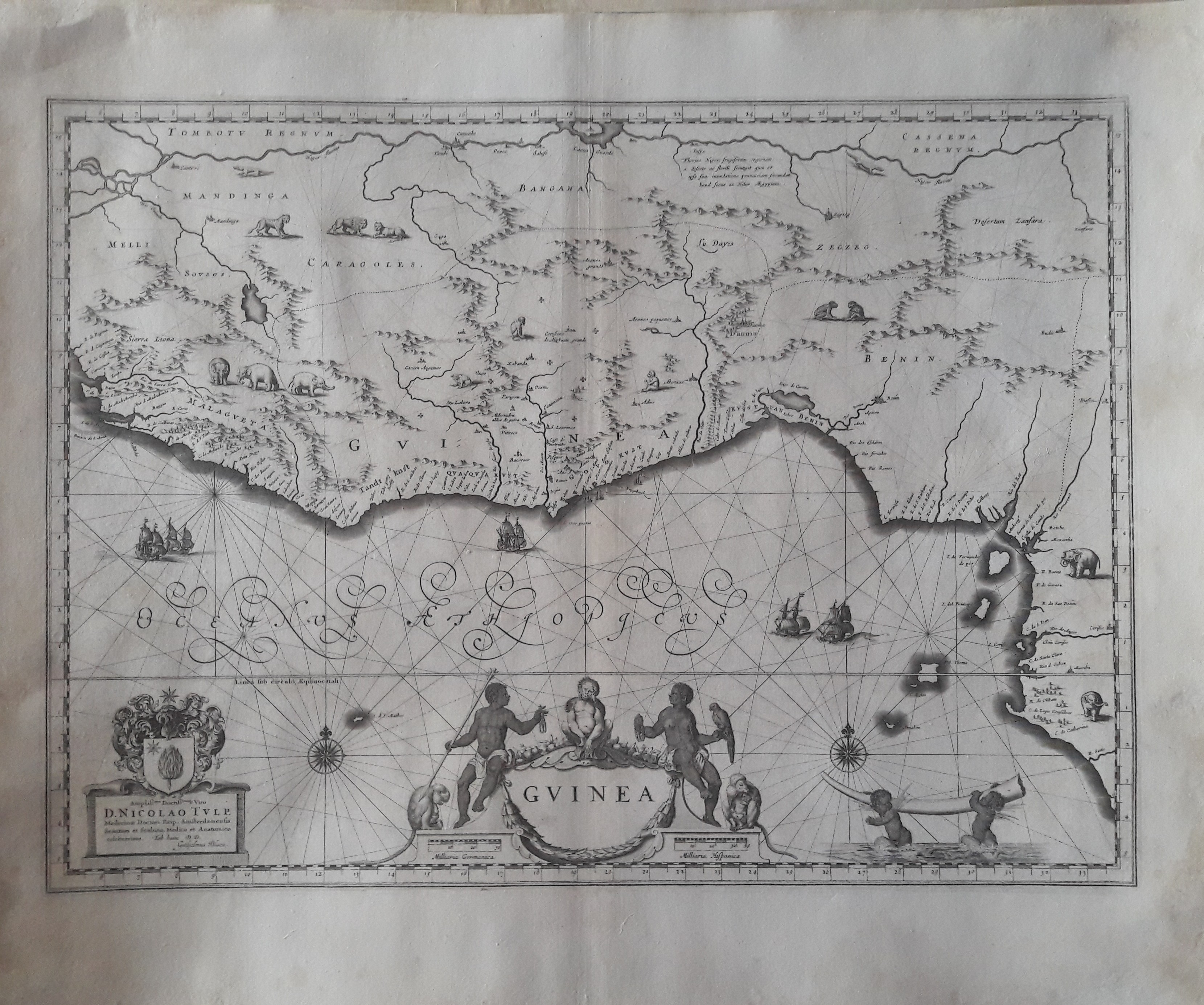
Guinea
Mapmakers
Blaeu
Gulf of Guinea
Edition date
1635
Edition place
Amsterdam
Editor
--
Atlas
Theatrum Orbis Terrarum, Sive Atlas Novis
Price
Please ask: info@thetreasuremaps.com
State
[mint/excellent/very good/GOOD/fair/mediocre/poor]
Color
Black/white
Verso
Franch text pag.4
Size
Plate: cm (53.3 x 38.1) inches (20.98 x 15) Paper: cm (61 x 50.8) inches (24.02 x 20)
Technique
Copper engraving
Note
No particular notes for this maps
Reference
--
Wiki
Here for more info
In stock
Available
Info
info@thetreasuremaps.com
Code
#0294
×
![]()
Map title
Aethiopia superior vel inferior
Mapmakers
Blaeu
LocationLocation shown in map
East Africa
Edition date
1635
Edition place
Amsterdam
Editor
--
Atlas
Theatrum Orbis Terrarum, Sive Atlas Novis
Price
Please ask: info@thetreasuremaps.com
State
[mint/excellent/very good/GOOD/fair/mediocre/poor]
Color
Black/white
Verso
Franch text pag.5
Size
Plate: cm (50.8 x 38.1) inches (20 x 15) Paper: cm (61 x 48.3) inches (24.02 x 19.02)
Technique
Copper engraving
Note
No particular notes for this maps
Reference
--
Wiki
Here for more info
In stock
Available
Info
info@thetreasuremaps.com
Code
#0295
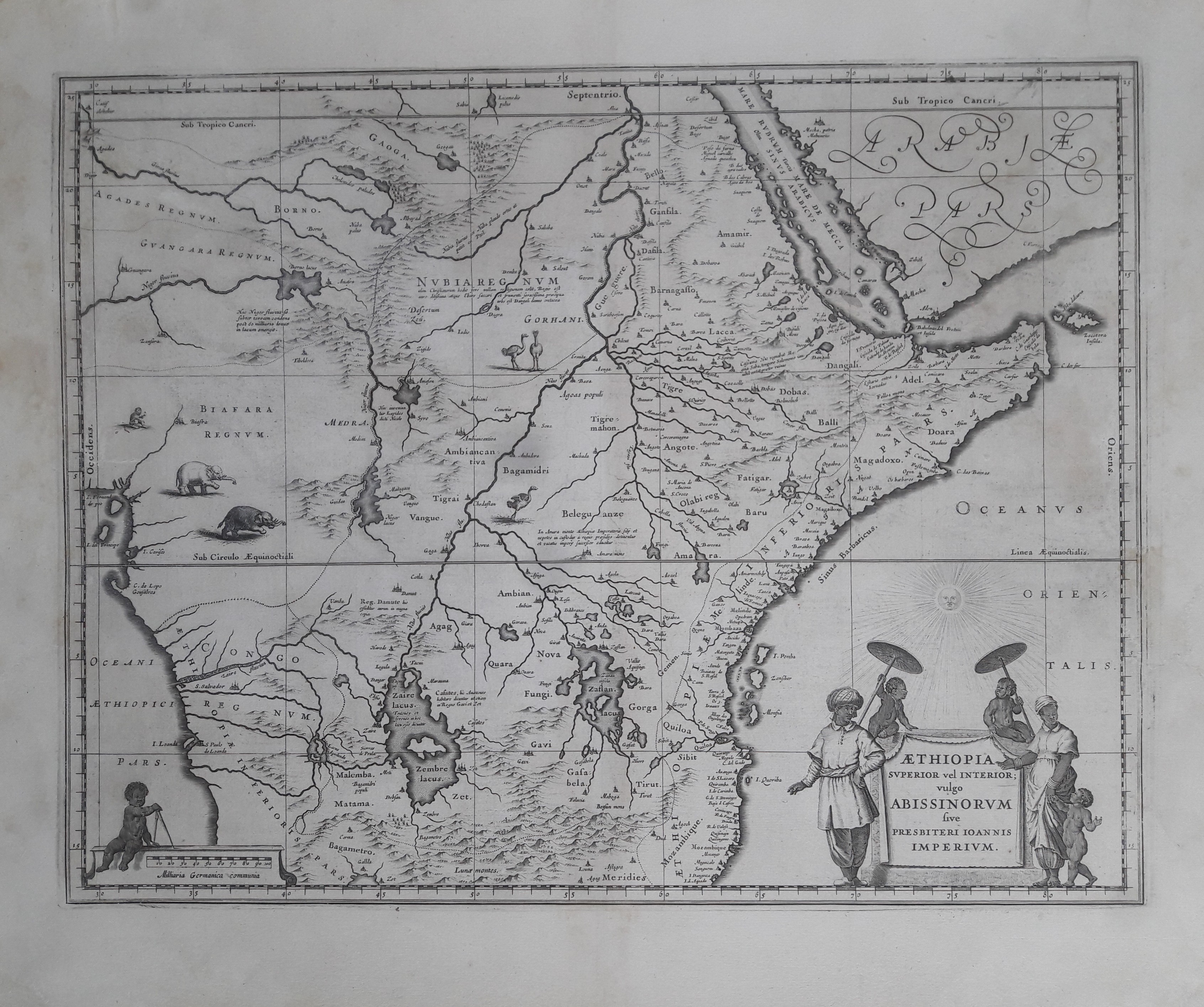
Aethiopia superior vel inferior
Mapmakers
Blaeu
East Africa
Edition date
1635
Edition place
Amsterdam
Editor
--
Atlas
Theatrum Orbis Terrarum, Sive Atlas Novis
Price
Please ask: info@thetreasuremaps.com
State
[mint/excellent/very good/GOOD/fair/mediocre/poor]
Color
Black/white
Verso
Franch text pag.5
Size
Plate: cm (50.8 x 38.1) inches (20 x 15) Paper: cm (61 x 48.3) inches (24.02 x 19.02)
Technique
Copper engraving
Note
No particular notes for this maps
Reference
--
Wiki
Here for more info
In stock
Available
Info
info@thetreasuremaps.com
Code
#0295
×
![]()
Map title
Utriusque Nili Albi et Atri Fonset Origo
Mapmakers
Scherer
LocationLocation shown in map
Central Africa
Edition date
1699
Edition place
Munich
Editor
Atlas
Price
250 Euro
State
[mint/EXCELLENT/very good/good/fair/mediocre/poor]
Color
Black/white
Verso
Blank
Size
Plate: cm (34 x 23) inches (13.39 x 9.06) Paper: cm (38 x 28) inches (14.96 x 11.02)
Technique
Copper engraving
Note
framed
Reference
Wiki
Here for more info
In stock
Available
Info
info@thetreasuremaps.com
Code
#1217
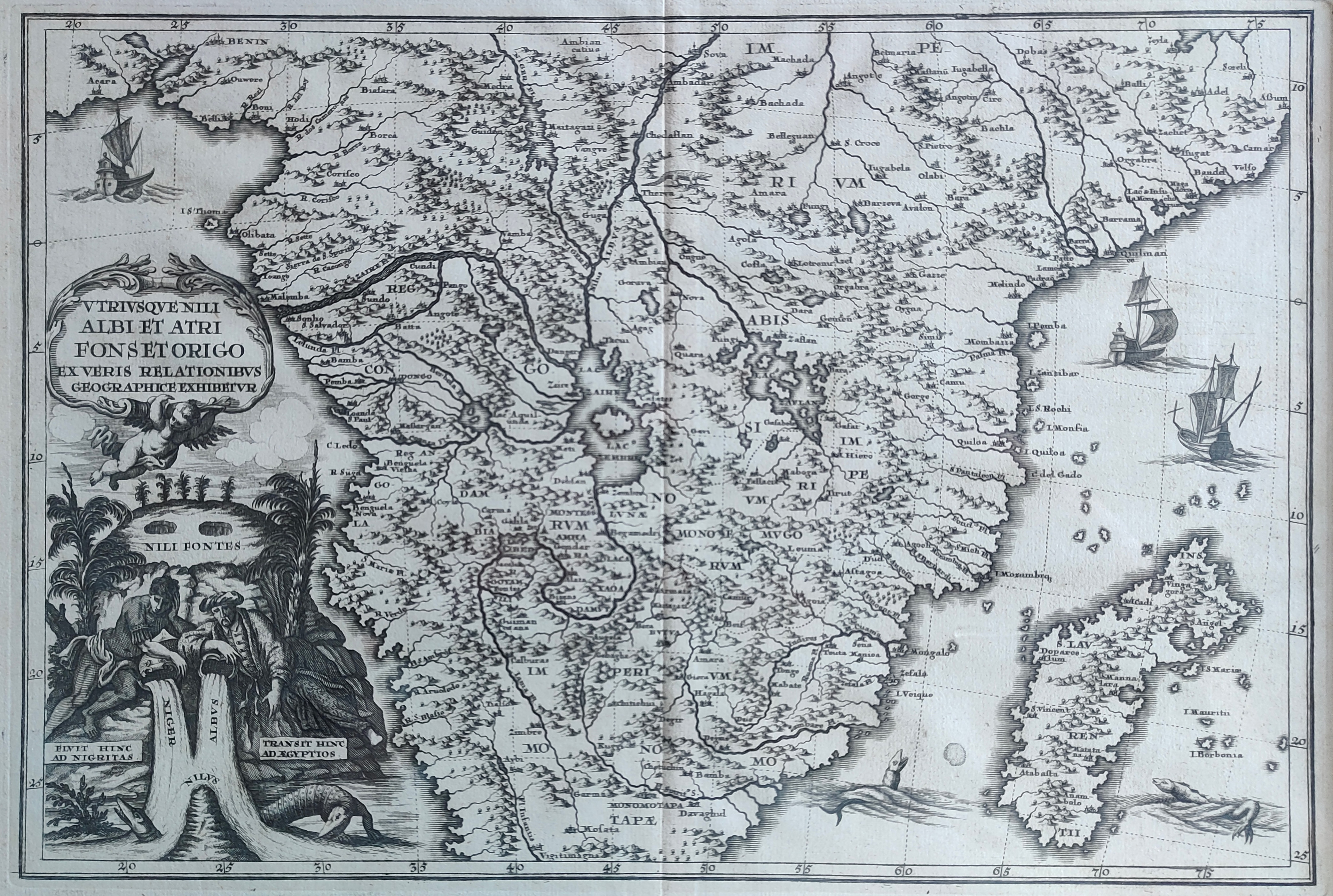
Utriusque Nili Albi et Atri Fonset Origo
Mapmakers
Scherer
Central Africa
Edition date
1699
Edition place
Munich
Editor
Atlas
Price
250 Euro
State
[mint/EXCELLENT/very good/good/fair/mediocre/poor]
Color
Black/white
Verso
Blank
Size
Plate: cm (34 x 23) inches (13.39 x 9.06) Paper: cm (38 x 28) inches (14.96 x 11.02)
Technique
Copper engraving
Note
framed
Reference
Wiki
Here for more info
In stock
Available
Info
info@thetreasuremaps.com
Code
#1217
×
![]()
Map title
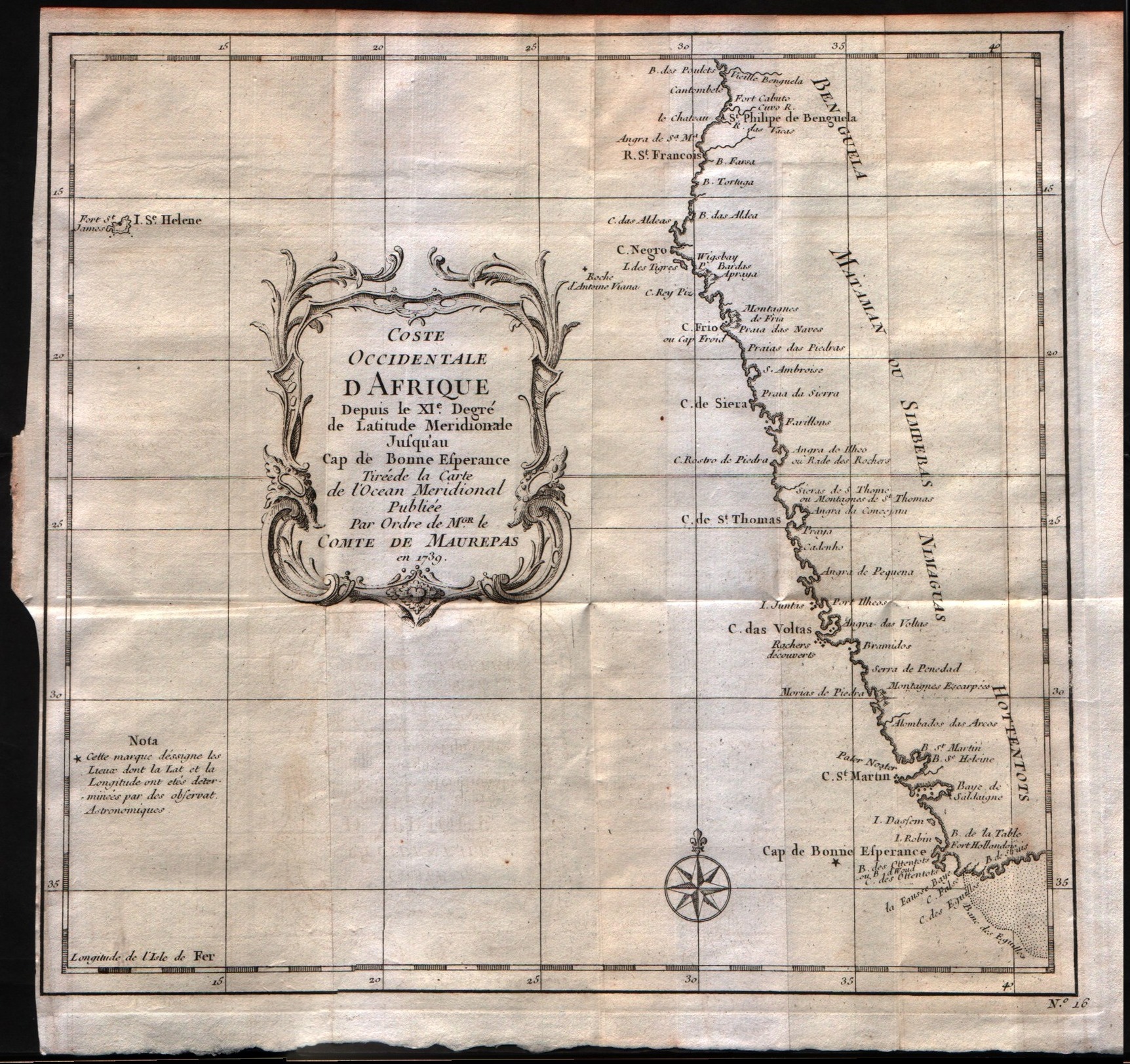
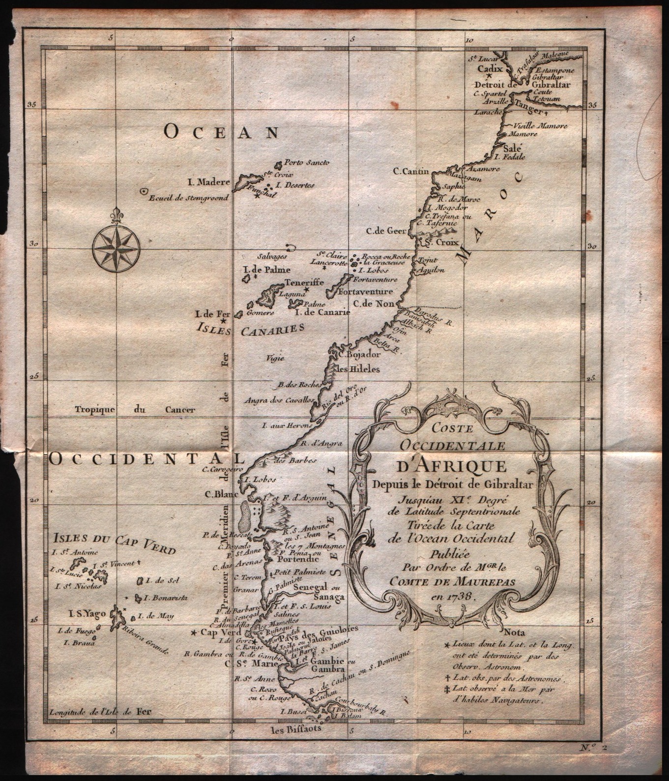
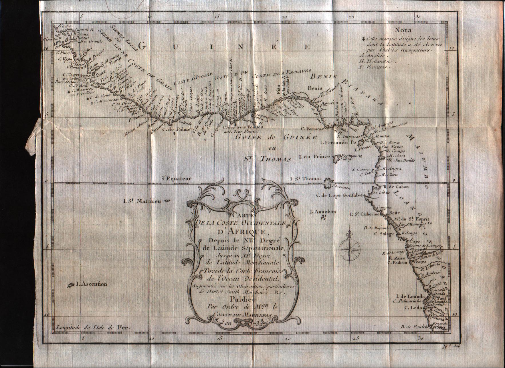
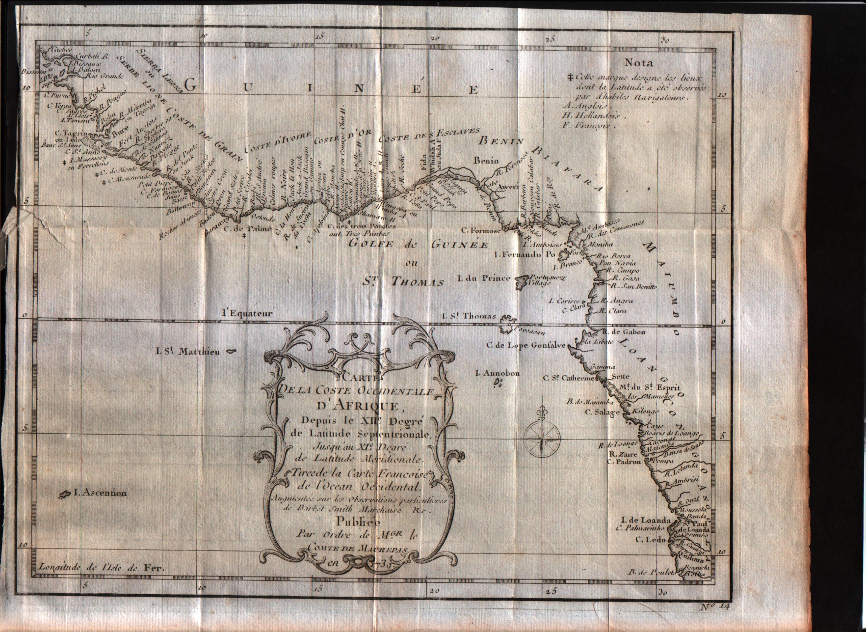
Costa occidentale d'Affrica dal XI grado di latitudine settentrionale sino al capo di Buona Speranza.
Mapmakers
Bellin
LocationLocation shown in map
West Africa
Edition date
1739
Edition place
--
Editor
--
Atlas
--
Price
Please ask: info@thetreasuremaps.com
State
[mint/excellent/VERY GOOD/good/fair/mediocre/poor]
Color
Black/white
Verso
Blank
Size
Plate: cm (25.4 x 22.9) inches (10 x 9.02) Paper: cm (26.7 x 25.4) inches (10.51 x 10)
Technique
Copper engraving
Note
The map is signed as to be printed by an order of Conte di Maurepas.
Reference
--
Wiki
Here for more info
In stock
Available
Info
info@thetreasuremaps.com
Code
#0299
Costa occidentale d'Affrica dal XI grado di latitudine settentrionale sino al capo di Buona Speranza.
Mapmakers
Bellin
West Africa
Edition date
1739
Edition place
--
Editor
--
Atlas
--
Price
Please ask: info@thetreasuremaps.com
State
[mint/excellent/VERY GOOD/good/fair/mediocre/poor]
Color
Black/white
Verso
Blank
Size
Plate: cm (25.4 x 22.9) inches (10 x 9.02) Paper: cm (26.7 x 25.4) inches (10.51 x 10)
Technique
Copper engraving
Note
The map is signed as to be printed by an order of Conte di Maurepas.
Reference
--
Wiki
Here for more info
In stock
Available
Info
info@thetreasuremaps.com
Code
#0299
×
![]()
Map title
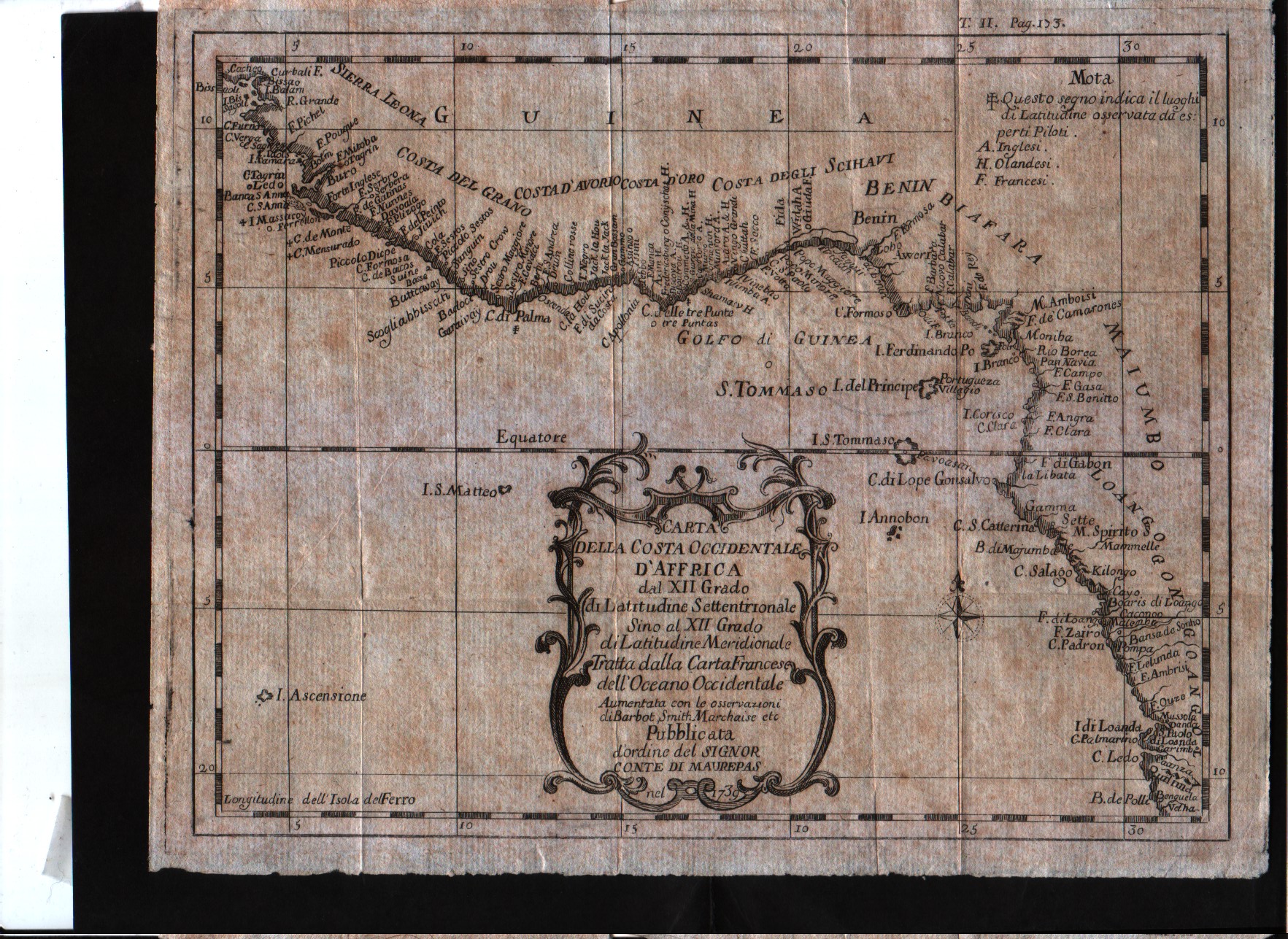
Carta della costa occidentale d'Affrica dal XII grado di latitudine settentrionale sino al XII grado di latitudine meridionale.
Mapmakers
Bellin
LocationLocation shown in map
West Africa
Edition date
1739
Edition place
--
Editor
--
Atlas
--
Price
Please ask: info@thetreasuremaps.com
State
[mint/excellent/VERY GOOD/good/fair/mediocre/poor]
Color
Black/white
Verso
Blank
Size
Plate: cm (24.1 x 19) inches (9.49 x 7.48) Paper: cm (26 x 21) inches (10.24 x 8.27)
Technique
Copper engraving
Note
The map is signed as to be printed by an order of Conte di Maurepas.
Reference
--
Wiki
Here for more info
In stock
Sold
Info
info@thetreasuremaps.com
Code
#0451
Carta della costa occidentale d'Affrica dal XII grado di latitudine settentrionale sino al XII grado di latitudine meridionale.
Mapmakers
Bellin
West Africa
Edition date
1739
Edition place
--
Editor
--
Atlas
--
Price
Please ask: info@thetreasuremaps.com
State
[mint/excellent/VERY GOOD/good/fair/mediocre/poor]
Color
Black/white
Verso
Blank
Size
Plate: cm (24.1 x 19) inches (9.49 x 7.48) Paper: cm (26 x 21) inches (10.24 x 8.27)
Technique
Copper engraving
Note
The map is signed as to be printed by an order of Conte di Maurepas.
Reference
--
Wiki
Here for more info
In stock
Sold
Info
info@thetreasuremaps.com
Code
#0451
×
![]()
Map title
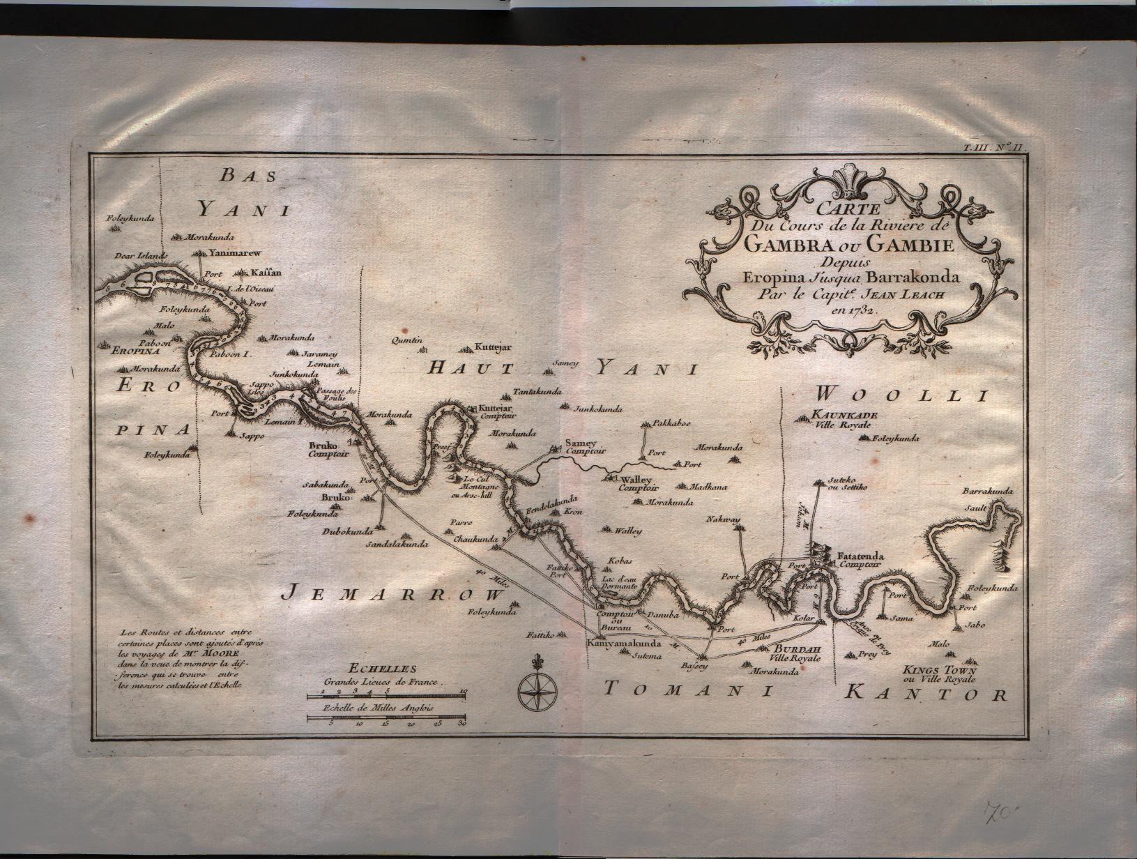
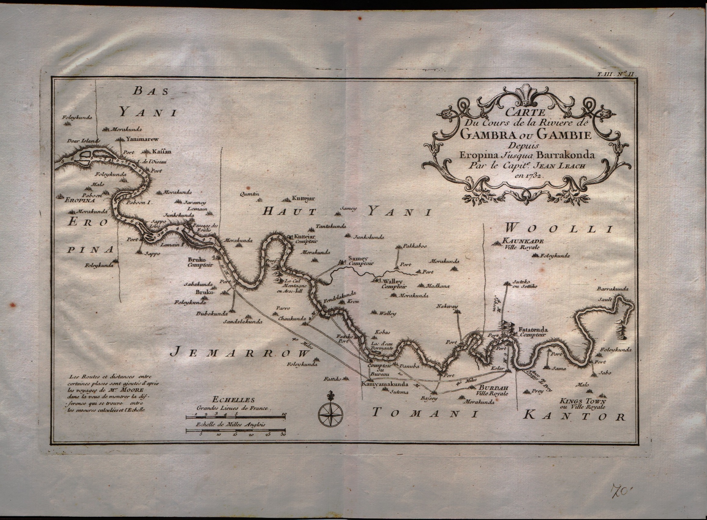
Carte du cours de la riviere de Gambra ou Gambie depuis Eropina u'j'usqua Barrakonda.
Mapmakers
Bellin
LocationLocation shown in map
Gambie river.
Edition date
1750
Edition place
Paris
Editor
--
Atlas
Historie General des Voyages -- Prevost
Price
Please ask: info@thetreasuremaps.com
State
[mint/EXCELLENT/very good/good/fair/mediocre/poor]
Color
Black/white
Verso
Blank
Size
Plate: cm (33 x 20.3) inches (12.99 x 7.99) Paper: cm (40.6 x 27.9) inches (15.98 x 10.98)
Technique
Copper engraving
Note
No particular notes for this maps
Reference
--
Wiki
Here for more info
In stock
Available
Info
info@thetreasuremaps.com
Code
#0325
Carte du cours de la riviere de Gambra ou Gambie depuis Eropina u'j'usqua Barrakonda.
Mapmakers
Bellin
Gambie river.
Edition date
1750
Edition place
Paris
Editor
--
Atlas
Historie General des Voyages -- Prevost
Price
Please ask: info@thetreasuremaps.com
State
[mint/EXCELLENT/very good/good/fair/mediocre/poor]
Color
Black/white
Verso
Blank
Size
Plate: cm (33 x 20.3) inches (12.99 x 7.99) Paper: cm (40.6 x 27.9) inches (15.98 x 10.98)
Technique
Copper engraving
Note
No particular notes for this maps
Reference
--
Wiki
Here for more info
In stock
Available
Info
info@thetreasuremaps.com
Code
#0325
×
![]()
Map title
Coste occidentale d'Afrique
Mapmakers
Bellin
LocationLocation shown in map
--
Edition date
1757
Edition place
Paris
Editor
--
Atlas
Historie General des Voyages -- Prevost
Price
Please ask: info@thetreasuremaps.com
State
[mint/EXCELLENT/very good/good/fair/mediocre/poor]
Color
Black/white
Verso
Blank
Size
Plate: cm (25.4 x 24.1) inches (10 x 9.49) Paper: cm (27.9 x 25.4) inches (10.98 x 10)
Technique
Copper engraving
Note
No particular notes for this maps
Reference
--
Wiki
Here for more info
In stock
Available
Info
info@thetreasuremaps.com
Code
#0301
Coste occidentale d'Afrique
Mapmakers
Bellin
--
Edition date
1757
Edition place
Paris
Editor
--
Atlas
Historie General des Voyages -- Prevost
Price
Please ask: info@thetreasuremaps.com
State
[mint/EXCELLENT/very good/good/fair/mediocre/poor]
Color
Black/white
Verso
Blank
Size
Plate: cm (25.4 x 24.1) inches (10 x 9.49) Paper: cm (27.9 x 25.4) inches (10.98 x 10)
Technique
Copper engraving
Note
No particular notes for this maps
Reference
--
Wiki
Here for more info
In stock
Available
Info
info@thetreasuremaps.com
Code
#0301
×
![]()
Map title
Partie de la coste de Guinee
Mapmakers
Bellin
LocationLocation shown in map
--
Edition date
1757
Edition place
Paris
Editor
--
Atlas
Historie General des Voyages -- Prevost
Price
Please ask: info@thetreasuremaps.com
State
[mint/EXCELLENT/very good/good/fair/mediocre/poor]
Color
Black/white
Verso
Blank
Size
Plate: cm (33 x 22.9) inches (12.99 x 9.02) Paper: cm (34.3 x 25.4) inches (13.5 x 10)
Technique
Copper engraving
Note
No particular notes for this maps
Reference
--
Wiki
Here for more info
In stock
Available
Info
info@thetreasuremaps.com
Code
#0302
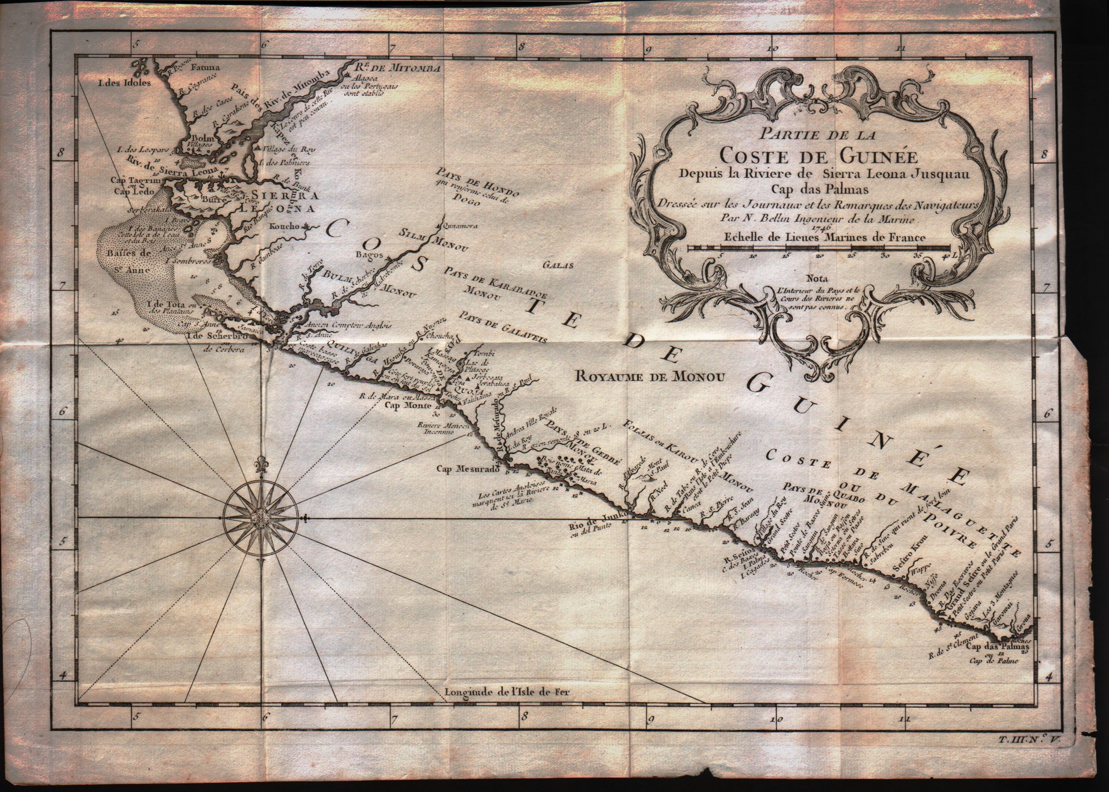
Partie de la coste de Guinee
Mapmakers
Bellin
--
Edition date
1757
Edition place
Paris
Editor
--
Atlas
Historie General des Voyages -- Prevost
Price
Please ask: info@thetreasuremaps.com
State
[mint/EXCELLENT/very good/good/fair/mediocre/poor]
Color
Black/white
Verso
Blank
Size
Plate: cm (33 x 22.9) inches (12.99 x 9.02) Paper: cm (34.3 x 25.4) inches (13.5 x 10)
Technique
Copper engraving
Note
No particular notes for this maps
Reference
--
Wiki
Here for more info
In stock
Available
Info
info@thetreasuremaps.com
Code
#0302
×
![]()
Map title
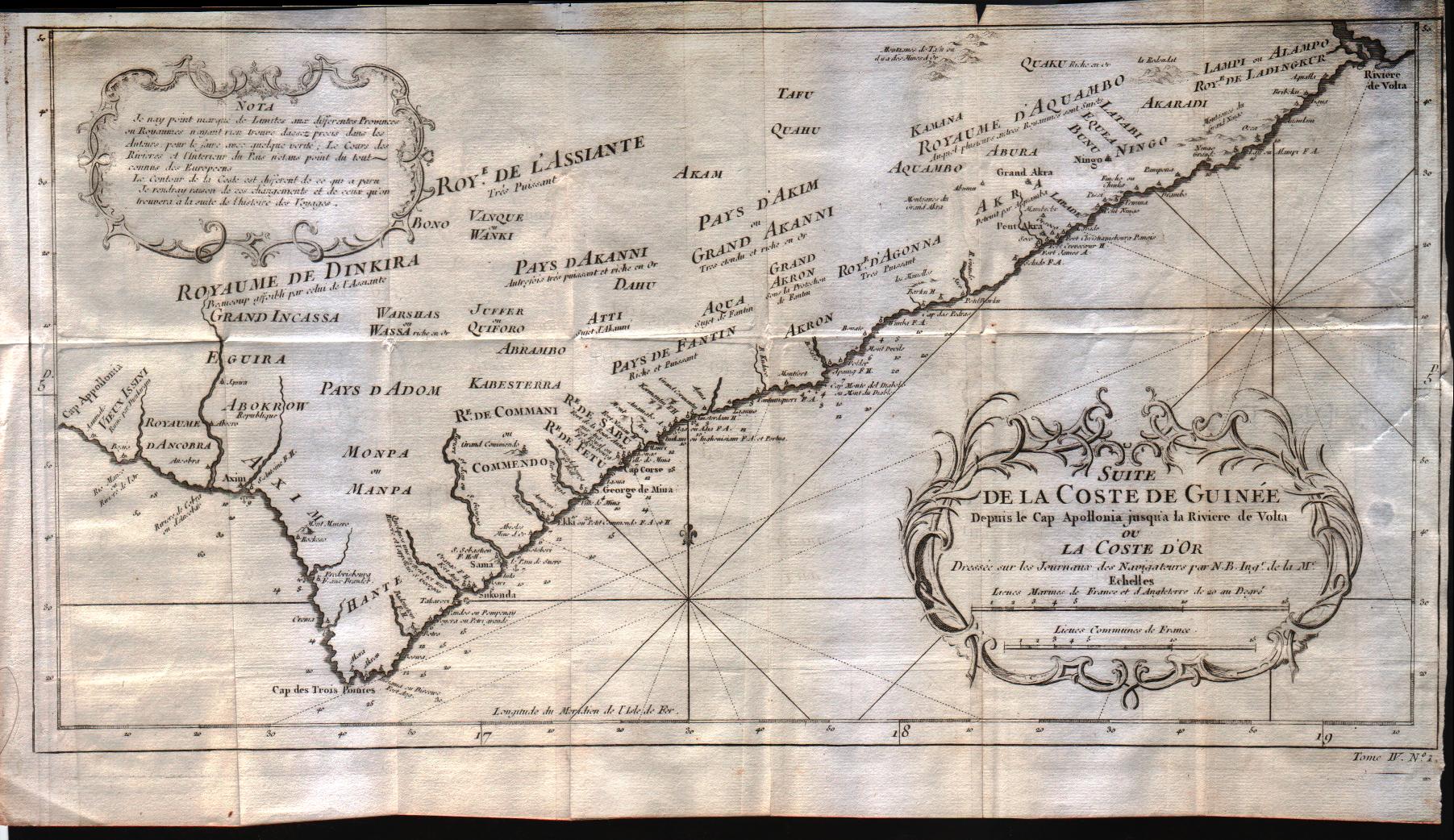
Suite de la coste de Guinee depuis le Cap Apollonia jusqua la riviere de Volta ou La Cote d'Or
Mapmakers
Bellin
LocationLocation shown in map
--
Edition date
1757
Edition place
Paris
Editor
--
Atlas
Historie General des Voyages -- Prevost
Price
Please ask: info@thetreasuremaps.com
State
[mint/EXCELLENT/very good/good/fair/mediocre/poor]
Color
Black/white
Verso
Blank
Size
Plate: cm (43.2 x 22.9) inches (17.01 x 9.02) Paper: cm (45.7 x 25.4) inches (17.99 x 10)
Technique
Copper engraving
Note
No particular notes for this maps
Reference
--
Wiki
Here for more info
In stock
Available
Info
info@thetreasuremaps.com
Code
#0303
Suite de la coste de Guinee depuis le Cap Apollonia jusqua la riviere de Volta ou La Cote d'Or
Mapmakers
Bellin
--
Edition date
1757
Edition place
Paris
Editor
--
Atlas
Historie General des Voyages -- Prevost
Price
Please ask: info@thetreasuremaps.com
State
[mint/EXCELLENT/very good/good/fair/mediocre/poor]
Color
Black/white
Verso
Blank
Size
Plate: cm (43.2 x 22.9) inches (17.01 x 9.02) Paper: cm (45.7 x 25.4) inches (17.99 x 10)
Technique
Copper engraving
Note
No particular notes for this maps
Reference
--
Wiki
Here for more info
In stock
Available
Info
info@thetreasuremaps.com
Code
#0303
×
![]()
Map title
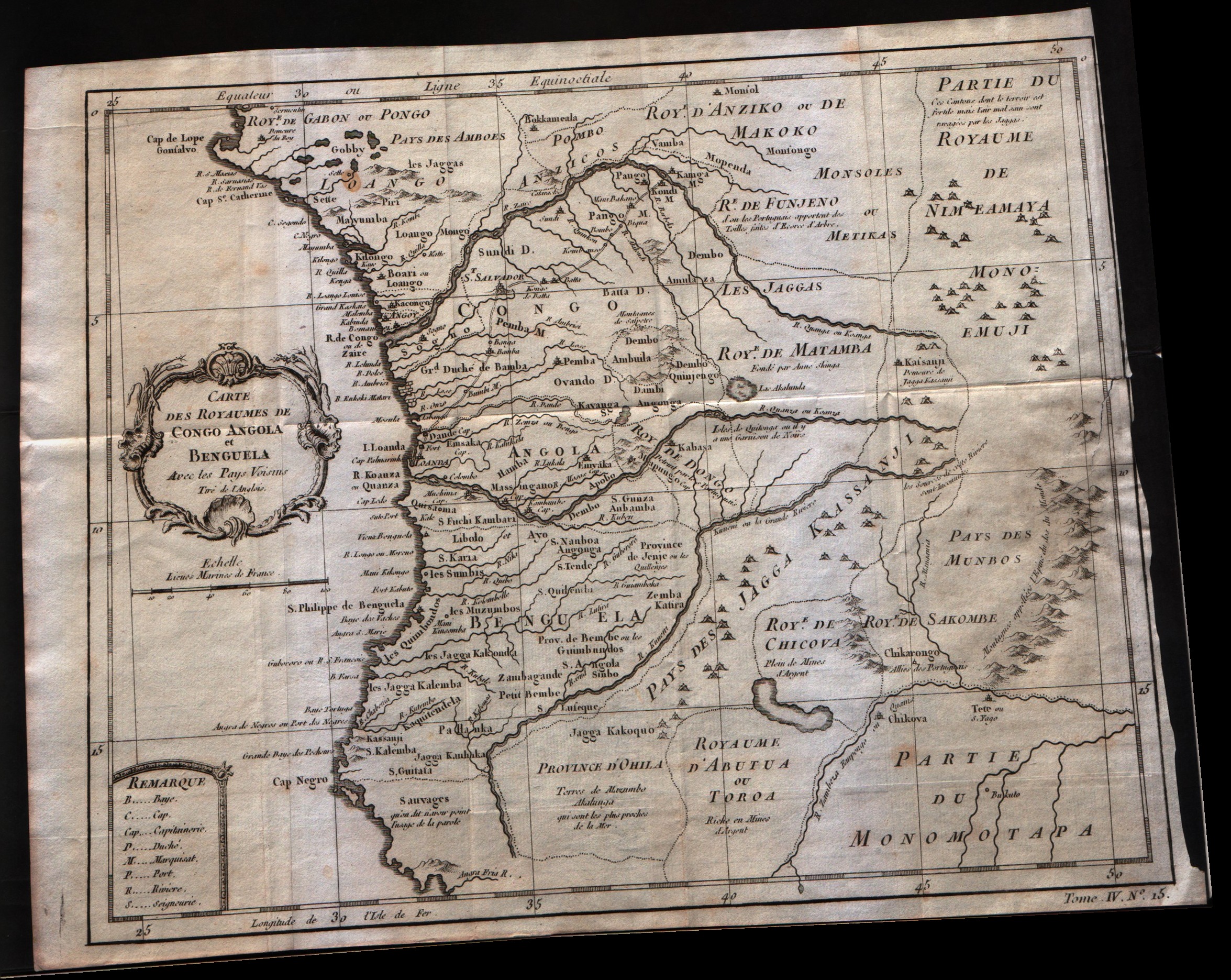
Carte Des Royaumes De Congo Angola Et Benguela
Mapmakers
Bellin
LocationLocation shown in map
--
Edition date
1757
Edition place
Paris
Editor
--
Atlas
Historie General des Voyages -- Prevost
Price
Please ask: info@thetreasuremaps.com
State
[mint/excellent/very good/GOOD/fair/mediocre/poor]
Color
Black/white
Verso
Blank
Size
Plate: cm (30.5 x 24.1) inches (12.01 x 9.49) Paper: cm (33 x 25.4) inches (12.99 x 10)
Technique
Copper engraving
Note
No particular notes for this maps
Reference
--
Wiki
Here for more info
In stock
Available
Info
info@thetreasuremaps.com
Code
#0304
Carte Des Royaumes De Congo Angola Et Benguela
Mapmakers
Bellin
--
Edition date
1757
Edition place
Paris
Editor
--
Atlas
Historie General des Voyages -- Prevost
Price
Please ask: info@thetreasuremaps.com
State
[mint/excellent/very good/GOOD/fair/mediocre/poor]
Color
Black/white
Verso
Blank
Size
Plate: cm (30.5 x 24.1) inches (12.01 x 9.49) Paper: cm (33 x 25.4) inches (12.99 x 10)
Technique
Copper engraving
Note
No particular notes for this maps
Reference
--
Wiki
Here for more info
In stock
Available
Info
info@thetreasuremaps.com
Code
#0304
×
![]()
Map title
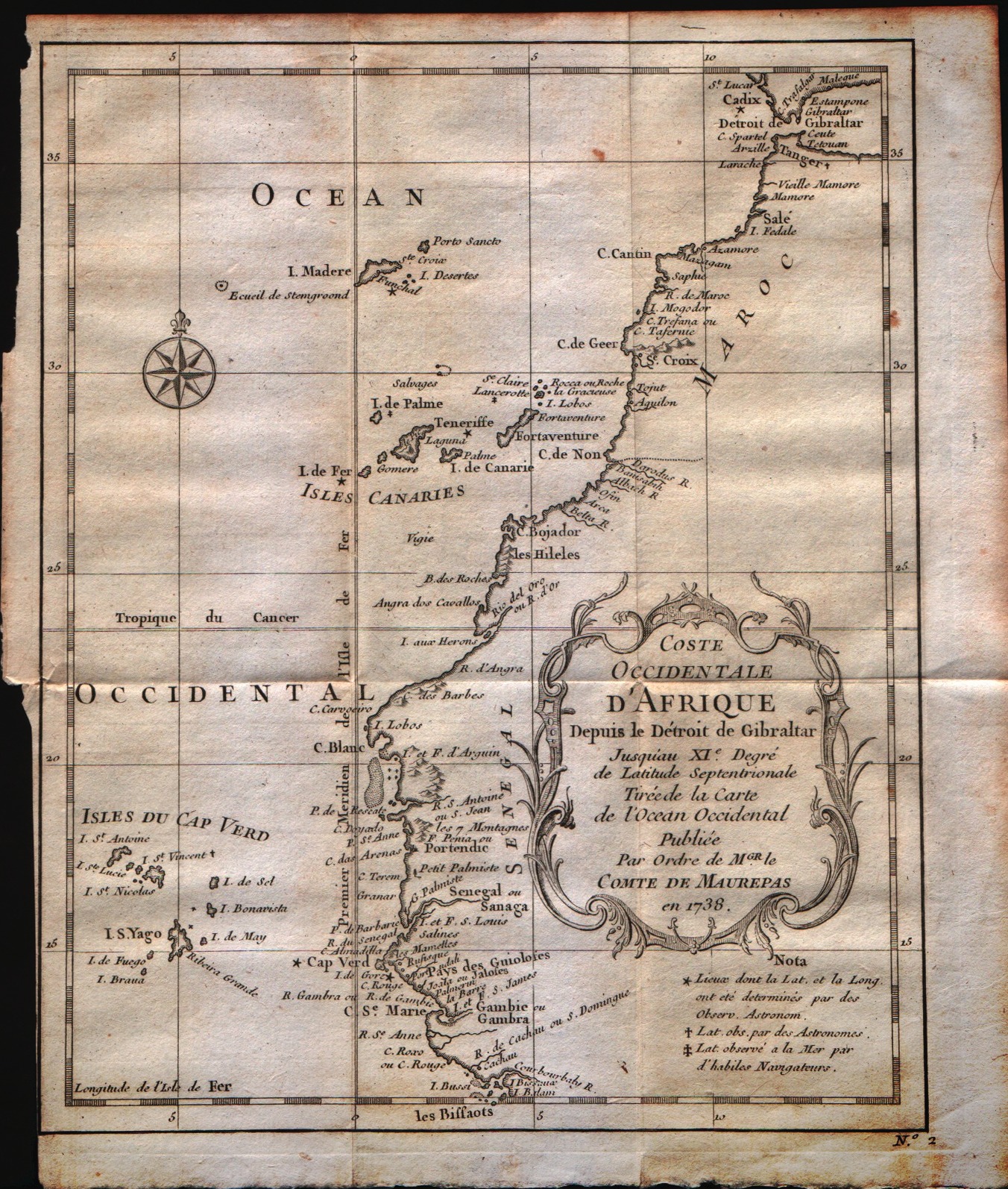
Coste occidentale d'Afrique depuis le detroit de Gibraltar
Mapmakers
Bellin
LocationLocation shown in map
West Africa
Edition date
1757
Edition place
Paris
Editor
--
Atlas
Historie General des Voyages -- Prevost
Price
Please ask: info@thetreasuremaps.com
State
[mint/excellent/VERY GOOD/good/fair/mediocre/poor]
Color
Black/white
Verso
Blank
Size
Plate: cm (20.3 x 24.1) inches (7.99 x 9.49) Paper: cm (22.9 x 25.4) inches (9.02 x 10)
Technique
Copper engraving
Note
No particular notes for this maps
Reference
--
Wiki
Here for more info
In stock
Available
Info
info@thetreasuremaps.com
Code
#0309
Coste occidentale d'Afrique depuis le detroit de Gibraltar
Mapmakers
Bellin
West Africa
Edition date
1757
Edition place
Paris
Editor
--
Atlas
Historie General des Voyages -- Prevost
Price
Please ask: info@thetreasuremaps.com
State
[mint/excellent/VERY GOOD/good/fair/mediocre/poor]
Color
Black/white
Verso
Blank
Size
Plate: cm (20.3 x 24.1) inches (7.99 x 9.49) Paper: cm (22.9 x 25.4) inches (9.02 x 10)
Technique
Copper engraving
Note
No particular notes for this maps
Reference
--
Wiki
Here for more info
In stock
Available
Info
info@thetreasuremaps.com
Code
#0309
×
![]()
Map title
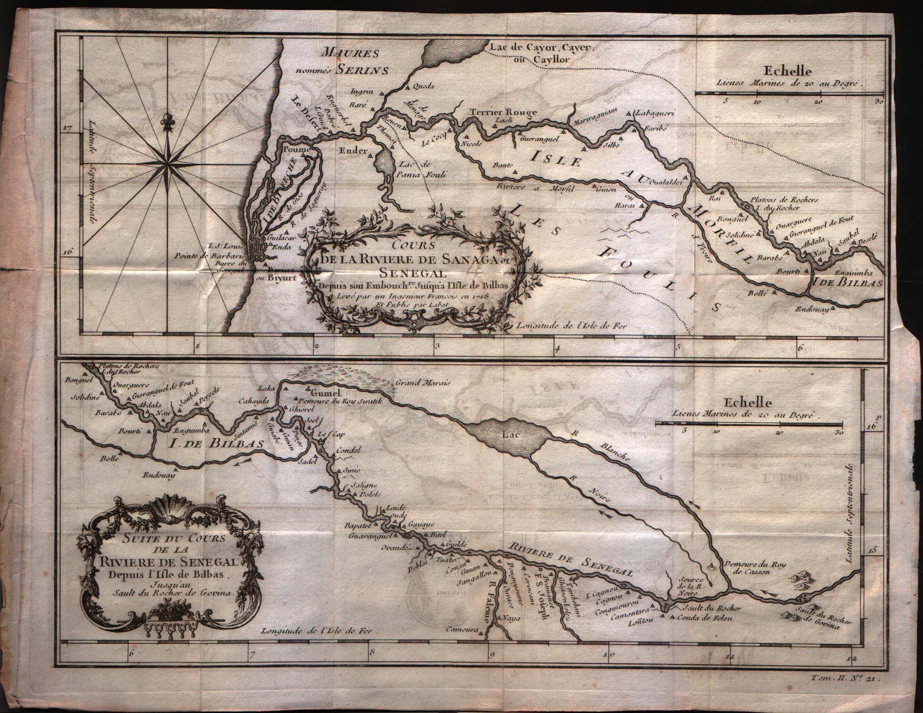
Suite du cours de la diviere de Senegal
Mapmakers
Bellin
LocationLocation shown in map
Comore islands
Edition date
1757
Edition place
Paris
Editor
--
Atlas
Historie General des Voyages -- Prevost
Price
Please ask: info@thetreasuremaps.com
State
[mint/excellent/VERY GOOD/good/fair/mediocre/poor]
Color
Black/white
Verso
Blank
Size
Plate: cm (27.9 x 22.9) inches (10.98 x 9.02) Paper: cm (31.8 x 24.1) inches (12.52 x 9.49)
Technique
Copper engraving
Note
No particular notes for this maps
Reference
--
Wiki
Here for more info
In stock
Available
Info
info@thetreasuremaps.com
Code
#0311
Suite du cours de la diviere de Senegal
Mapmakers
Bellin
Comore islands
Edition date
1757
Edition place
Paris
Editor
--
Atlas
Historie General des Voyages -- Prevost
Price
Please ask: info@thetreasuremaps.com
State
[mint/excellent/VERY GOOD/good/fair/mediocre/poor]
Color
Black/white
Verso
Blank
Size
Plate: cm (27.9 x 22.9) inches (10.98 x 9.02) Paper: cm (31.8 x 24.1) inches (12.52 x 9.49)
Technique
Copper engraving
Note
No particular notes for this maps
Reference
--
Wiki
Here for more info
In stock
Available
Info
info@thetreasuremaps.com
Code
#0311
×
![]()
Map title
Carte de la coste Occidentale d'Afrique Depuis le XII degree de latitude Septentrionale
Mapmakers
Bellin
LocationLocation shown in map
West Afrique
Edition date
1757
Edition place
Paris
Editor
--
Atlas
Historie General des Voyages -- Prevost
Price
Please ask: info@thetreasuremaps.com
State
[mint/excellent/VERY GOOD/good/fair/mediocre/poor]
Color
Black/white
Verso
Blank
Size
Plate: cm (25.4 x 20.3) inches (10 x 7.99) Paper: cm (27.9 x 22.9) inches (10.98 x 9.02)
Technique
Copper engraving
Note
No particular notes for this maps
Reference
--
Wiki
Here for more info
In stock
Available
Info
info@thetreasuremaps.com
Code
#0312
Carte de la coste Occidentale d'Afrique Depuis le XII degree de latitude Septentrionale
Mapmakers
Bellin
West Afrique
Edition date
1757
Edition place
Paris
Editor
--
Atlas
Historie General des Voyages -- Prevost
Price
Please ask: info@thetreasuremaps.com
State
[mint/excellent/VERY GOOD/good/fair/mediocre/poor]
Color
Black/white
Verso
Blank
Size
Plate: cm (25.4 x 20.3) inches (10 x 7.99) Paper: cm (27.9 x 22.9) inches (10.98 x 9.02)
Technique
Copper engraving
Note
No particular notes for this maps
Reference
--
Wiki
Here for more info
In stock
Available
Info
info@thetreasuremaps.com
Code
#0312
×
![]()
Map title
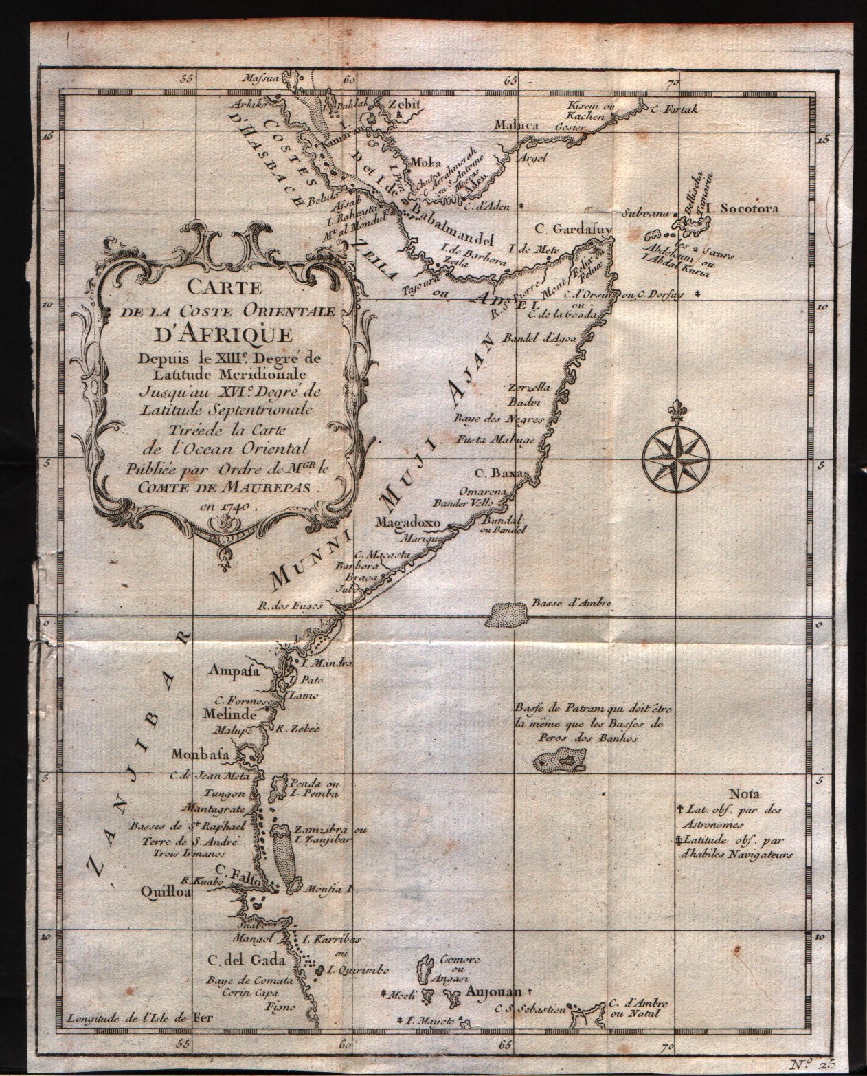
Carte de la Coste Orientale d'Afrique depuis le XIII ...
Mapmakers
Bellin
LocationLocation shown in map
East Africa
Edition date
1757
Edition place
Paris
Editor
--
Atlas
Historie General des Voyages -- Prevost
Price
Please ask: info@thetreasuremaps.com
State
[mint/excellent/VERY GOOD/good/fair/mediocre/poor]
Color
Black/white
Verso
Blank
Size
Plate: cm (20.3 x 24.1) inches (7.99 x 9.49) Paper: cm (20.3 x 25.4) inches (7.99 x 10)
Technique
Copper engraving
Note
No particular notes for this maps
Reference
--
Wiki
Here for more info
In stock
Available
Info
info@thetreasuremaps.com
Code
#0318
Carte de la Coste Orientale d'Afrique depuis le XIII ...
Mapmakers
Bellin
East Africa
Edition date
1757
Edition place
Paris
Editor
--
Atlas
Historie General des Voyages -- Prevost
Price
Please ask: info@thetreasuremaps.com
State
[mint/excellent/VERY GOOD/good/fair/mediocre/poor]
Color
Black/white
Verso
Blank
Size
Plate: cm (20.3 x 24.1) inches (7.99 x 9.49) Paper: cm (20.3 x 25.4) inches (7.99 x 10)
Technique
Copper engraving
Note
No particular notes for this maps
Reference
--
Wiki
Here for more info
In stock
Available
Info
info@thetreasuremaps.com
Code
#0318
×
![]()
Map title
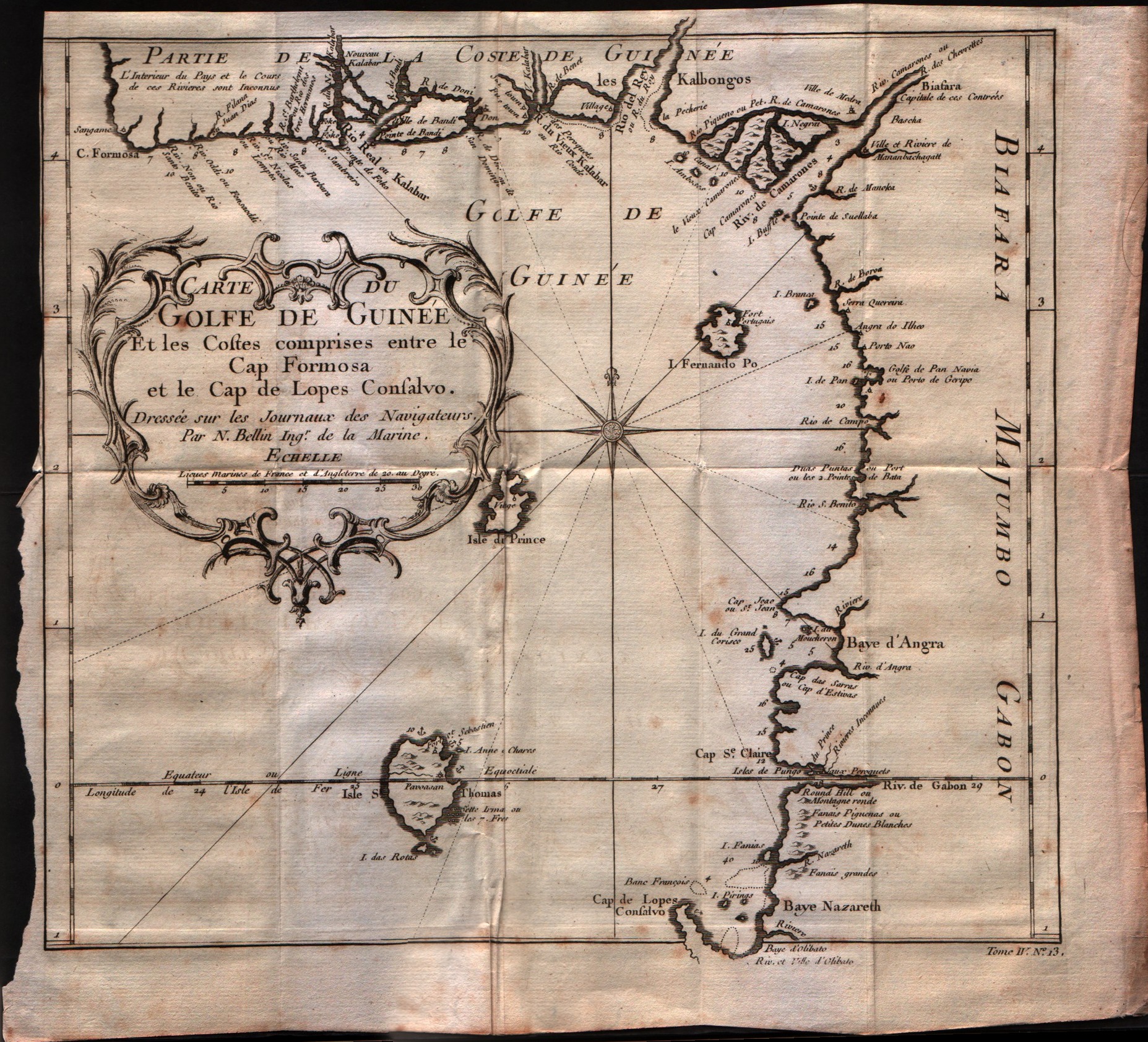
Carte du Golfe de Guinee et les costes comprises entre le Cap Formosa ...
Mapmakers
Bellin
LocationLocation shown in map
Gulf of Guinee
Edition date
1757
Edition place
Paris
Editor
--
Atlas
Historie General des Voyages -- Prevost
Price
Please ask: info@thetreasuremaps.com
State
[mint/excellent/VERY GOOD/good/fair/mediocre/poor]
Color
Black/white
Verso
Blank
Size
Plate: cm (27.9 x 25.4) inches (10.98 x 10) Paper: cm (30.5 x 27.9) inches (12.01 x 10.98)
Technique
Copper engraving
Note
No particular notes for this maps
Reference
--
Wiki
Here for more info
In stock
Available
Info
info@thetreasuremaps.com
Code
#0319
Carte du Golfe de Guinee et les costes comprises entre le Cap Formosa ...
Mapmakers
Bellin
Gulf of Guinee
Edition date
1757
Edition place
Paris
Editor
--
Atlas
Historie General des Voyages -- Prevost
Price
Please ask: info@thetreasuremaps.com
State
[mint/excellent/VERY GOOD/good/fair/mediocre/poor]
Color
Black/white
Verso
Blank
Size
Plate: cm (27.9 x 25.4) inches (10.98 x 10) Paper: cm (30.5 x 27.9) inches (12.01 x 10.98)
Technique
Copper engraving
Note
No particular notes for this maps
Reference
--
Wiki
Here for more info
In stock
Available
Info
info@thetreasuremaps.com
Code
#0319
×
![]()
Map title
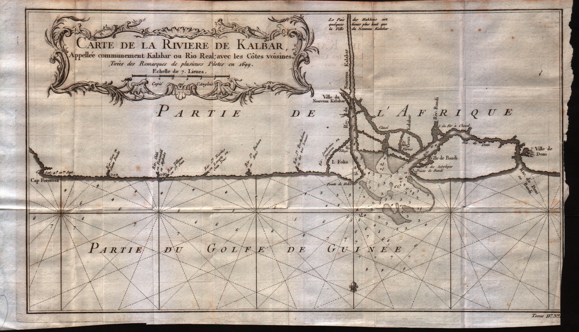
Carte de la riviere de Kalbar
Mapmakers
Bellin
LocationLocation shown in map
--
Edition date
1757
Edition place
Paris
Editor
--
Atlas
Historie General des Voyages -- Prevost
Price
Please ask: info@thetreasuremaps.com
State
[mint/excellent/VERY GOOD/good/fair/mediocre/poor]
Color
Black/white
Verso
Blank
Size
Plate: cm (35.6 x 20.3) inches (14.02 x 7.99) Paper: cm (38.1 x 22.9) inches (15 x 9.02)
Technique
Copper engraving
Note
No particular notes for this maps
Reference
--
Wiki
Here for more info
In stock
Available
Info
info@thetreasuremaps.com
Code
#0320
Carte de la riviere de Kalbar
Mapmakers
Bellin
--
Edition date
1757
Edition place
Paris
Editor
--
Atlas
Historie General des Voyages -- Prevost
Price
Please ask: info@thetreasuremaps.com
State
[mint/excellent/VERY GOOD/good/fair/mediocre/poor]
Color
Black/white
Verso
Blank
Size
Plate: cm (35.6 x 20.3) inches (14.02 x 7.99) Paper: cm (38.1 x 22.9) inches (15 x 9.02)
Technique
Copper engraving
Note
No particular notes for this maps
Reference
--
Wiki
Here for more info
In stock
Available
Info
info@thetreasuremaps.com
Code
#0320
×
![]()
Map title
Carte du cours de la riviere de Gambia ou Gambie depuis ...
Mapmakers
Bellin
LocationLocation shown in map
Gambia river
Edition date
1757
Edition place
Paris
Editor
--
Atlas
Historie General des Voyages -- Prevost
Price
Please ask: info@thetreasuremaps.com
State
[mint/excellent/VERY GOOD/good/fair/mediocre/poor]
Color
Black/white
Verso
Blank
Size
Plate: cm (31.8 x 20.3) inches (12.52 x 7.99) Paper: cm (35.6 x 22.9) inches (14.02 x 9.02)
Technique
Copper engraving
Note
No particular notes for this maps
Reference
--
Wiki
Here for more info
In stock
Available
Info
info@thetreasuremaps.com
Code
#0321
Carte du cours de la riviere de Gambia ou Gambie depuis ...
Mapmakers
Bellin
Gambia river
Edition date
1757
Edition place
Paris
Editor
--
Atlas
Historie General des Voyages -- Prevost
Price
Please ask: info@thetreasuremaps.com
State
[mint/excellent/VERY GOOD/good/fair/mediocre/poor]
Color
Black/white
Verso
Blank
Size
Plate: cm (31.8 x 20.3) inches (12.52 x 7.99) Paper: cm (35.6 x 22.9) inches (14.02 x 9.02)
Technique
Copper engraving
Note
No particular notes for this maps
Reference
--
Wiki
Here for more info
In stock
Available
Info
info@thetreasuremaps.com
Code
#0321
×
![]()
Map title
Carte de la coste Occidentale d'Afrique Depuis le XII degree de latitude Septentrionale
Mapmakers
Bellin
LocationLocation shown in map
West Africa
Edition date
1757
Edition place
Paris
Editor
--
Atlas
--
Price
Please ask: info@thetreasuremaps.com
State
[mint/excellent/VERY GOOD/good/fair/mediocre/poor]
Color
Black/white
Verso
Blank
Size
Plate: cm (24.1 x 19) inches (9.49 x 7.48) Paper: cm (27.9 x 22.9) inches (10.98 x 9.02)
Technique
Copper engraving
Note
No particular notes for this maps
Reference
--
Wiki
Here for more info
In stock
Available
Info
info@thetreasuremaps.com
Code
#0550
Carte de la coste Occidentale d'Afrique Depuis le XII degree de latitude Septentrionale
Mapmakers
Bellin
West Africa
Edition date
1757
Edition place
Paris
Editor
--
Atlas
--
Price
Please ask: info@thetreasuremaps.com
State
[mint/excellent/VERY GOOD/good/fair/mediocre/poor]
Color
Black/white
Verso
Blank
Size
Plate: cm (24.1 x 19) inches (9.49 x 7.48) Paper: cm (27.9 x 22.9) inches (10.98 x 9.02)
Technique
Copper engraving
Note
No particular notes for this maps
Reference
--
Wiki
Here for more info
In stock
Available
Info
info@thetreasuremaps.com
Code
#0550
×
![]()