Central America
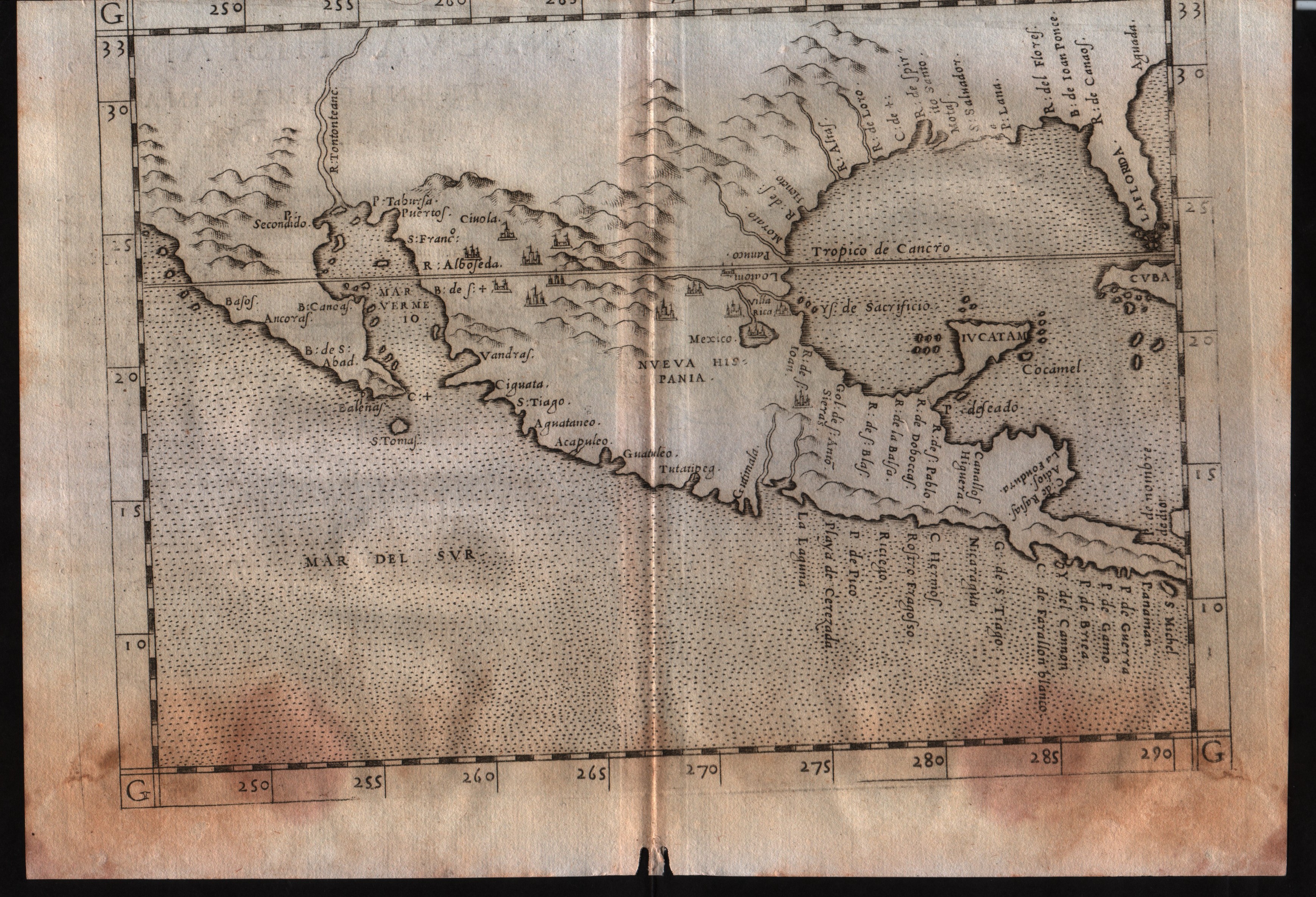
Map title
Nueva Hispania tabula nova
Author
Ruscelli
Location shown in map
Mexico
Edition date
1561
Edition place
Venice
Editor
Vincenzo Valgrisi
Atlas
La Geographia di Claudio Tolomeo
Price
400 Euro
State
[mint/excellent/very good/GOOD/fair/mediocre/poor]
Color
Black/white
Verso
Italian text pag.31
Size
Plate: cm (26 x 19) inches (10.24 x 7.48) Paper: cm (27.9 x 20.3) inches (10.98 x 7.99)
Technique
Copper engraving
Note
--
Reference
--
Wiki
Here for more info
In stock
Available
Info
info@thetreasuremaps.com
Code
#0535
×
![Nueva Hispania tabula nova by Ruscelli, Mexico, 1561]()
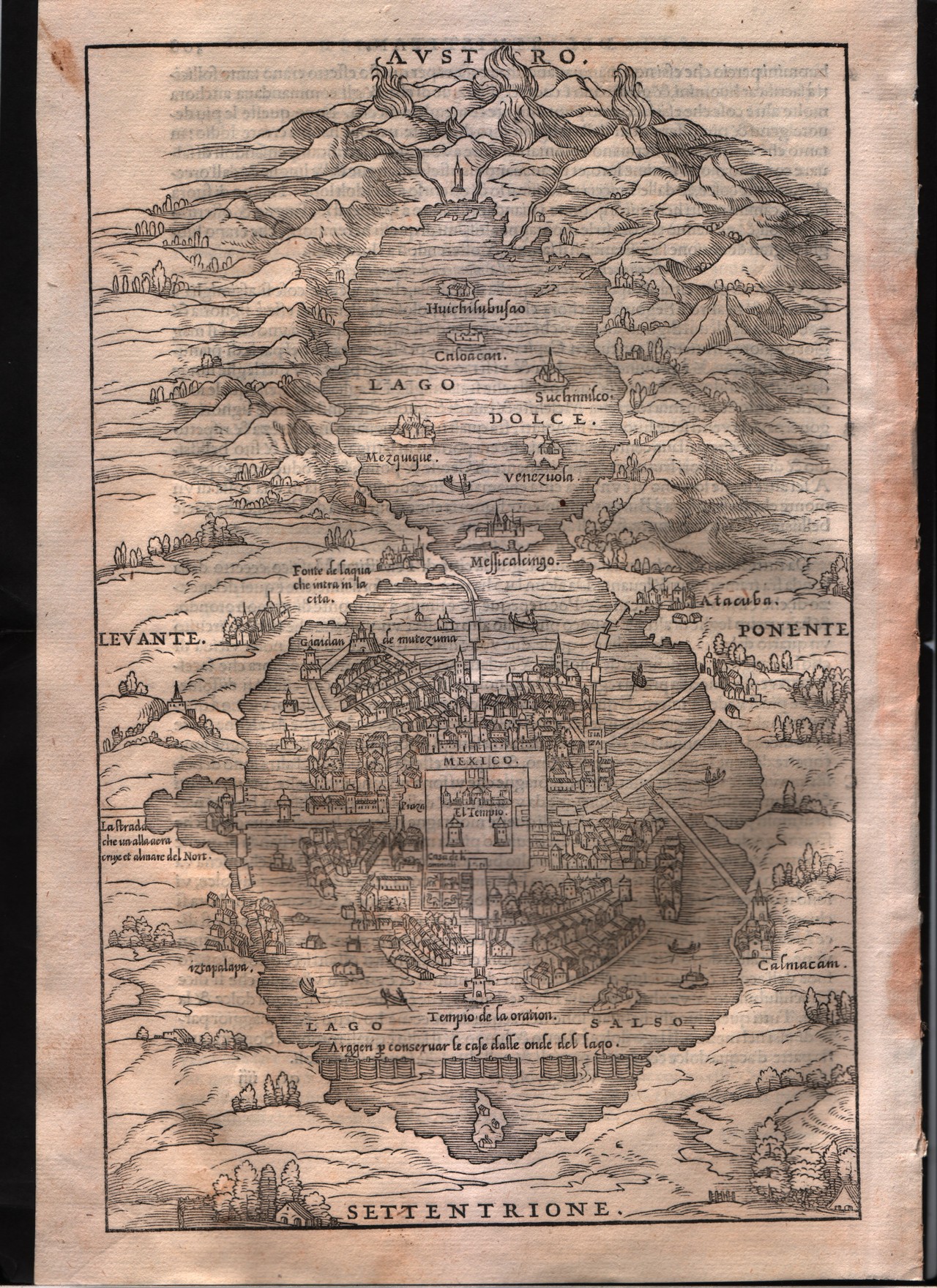
Map title
--
Author
Gastaldi
Location shown in map
Mexico city
Edition date
1613
Edition place
Venice
Editor
Giambattista Ramusio
Atlas
Delle navigazioni e viaggi
Price
200 Euro
State
[mint/EXCELLENT/very good/good/fair/mediocre/poor]
Color
Black/white
Verso
Italian text pag.309
Size
Plate: cm (17.8 x 26.7) inches (7.01 x 10.51) Paper: cm (20.3 x 30.5) inches (7.99 x 12.01)
Technique
Woodcut
Note
--
Reference
--
Wiki
Here for more info
In stock
Sold
Info
info@thetreasuremaps.com
Code
#0339
--
Author
Gastaldi
Location shown in map
Mexico city
Edition date
1613
Edition place
Venice
Editor
Giambattista Ramusio
Atlas
Delle navigazioni e viaggi
Price
200 Euro
State
[mint/EXCELLENT/very good/good/fair/mediocre/poor]
Color
Black/white
Verso
Italian text pag.309
Size
Plate: cm (17.8 x 26.7) inches (7.01 x 10.51) Paper: cm (20.3 x 30.5) inches (7.99 x 12.01)
Technique
Woodcut
Note
--
Reference
--
Wiki
Here for more info
In stock
Sold
Info
info@thetreasuremaps.com
Code
#0339
×
![-- by Gastaldi, Mexico city, 1613]()
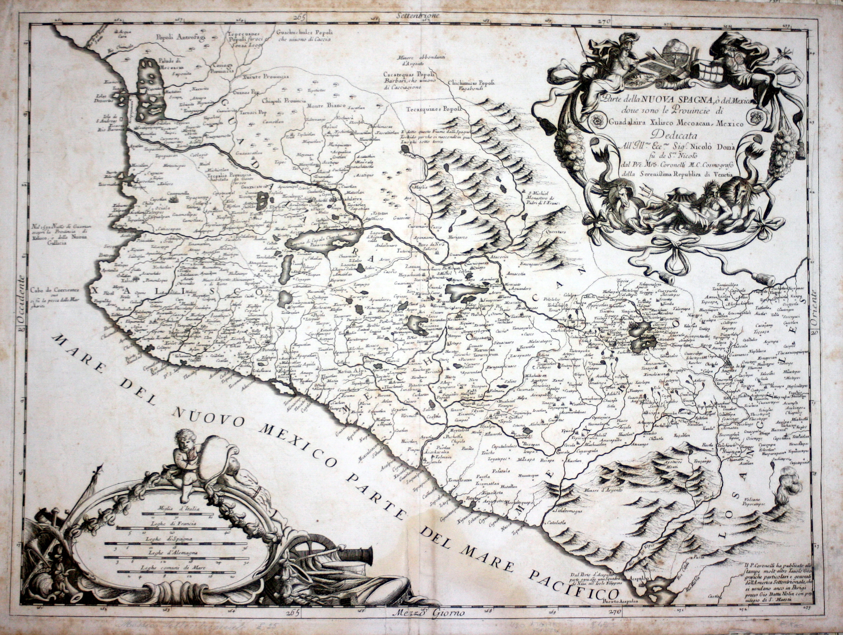
Map title
Parte della Nuova Spagna o del Messico
Author
Coronelli
Location shown in map
West Mexic
Edition date
Circa 1696
Edition place
Venice
Editor
--
Atlas
Atlante veneto
Price
600 Euro
State
[mint/EXCELLENT/very good/good/fair/mediocre/poor]
Color
Black/white
Verso
Blank
Size
Plate: cm (61 x 45.7) inches (24.02 x 17.99) Paper: cm (66 x 48.3) inches (25.98 x 19.02)
Technique
Copper engraving
Note
No particular notes for this maps
Reference
--
Wiki
Here for more info
In stock
Available
Info
info@thetreasuremaps.com
Code
#0345
×
![Parte della Nuova Spagna o del Messico by Coronelli, West Mexic, Circa 1696]()

Map title
Carte des environs de la ville de Mexico
Author
Bellin
Location shown in map
Map of Mexico city
Edition date
1757
Edition place
Paris
Editor
--
Atlas
Historie General des Voyages -- Prevost
Price
Please ask: info@thetreasuremaps.com
State
[mint/EXCELLENT/very good/good/fair/mediocre/poor]
Color
Black/white
Verso
Blank
Size
Plate: cm (17.8 x 22.9) inches (7.01 x 9.02) Paper: cm (16.5 x 20.3) inches (6.5 x 7.99)
Technique
Copper engraving
Note
No particular notes for this maps
Reference
--
Wiki
Here for more info
In stock
Sold
Info
info@thetreasuremaps.com
Code
#0346
×
![Carte des environs de la ville de Mexico by Bellin, Map of Mexico city, 1757]()
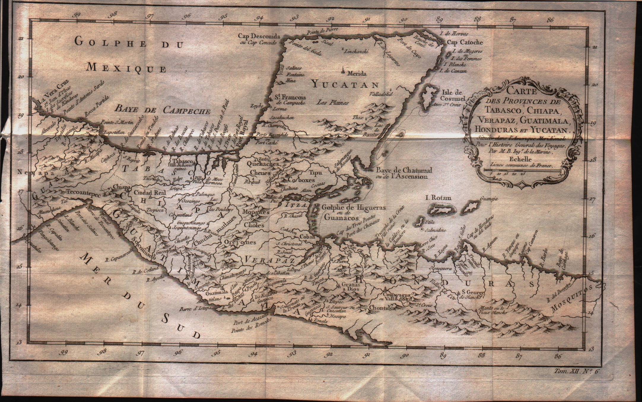
Map title
Carte des Provinces de Tabasco, Chiapa, Verapaz, Guatimala, Honduras et Yucatan
Author
Bellin
Location shown in map
--
Edition date
1757
Edition place
Paris
Editor
--
Atlas
Historie General des Voyages -- Prevost
Price
75 Euro
State
[mint/EXCELLENT/very good/good/fair/mediocre/poor]
Color
Black/white
Verso
Blank
Size
Plate: cm (33 x 20.3) inches (12.99 x 7.99) Paper: cm (35.6 x 22.9) inches (14.02 x 9.02)
Technique
Copper engraving
Note
No particular notes for this maps
Reference
--
Wiki
Here for more info
In stock
Available
Info
info@thetreasuremaps.com
Code
#0348
×
![Carte des Provinces de Tabasco, Chiapa, Verapaz, Guatimala, Honduras et Yucatan by Bellin, --, 1757]()
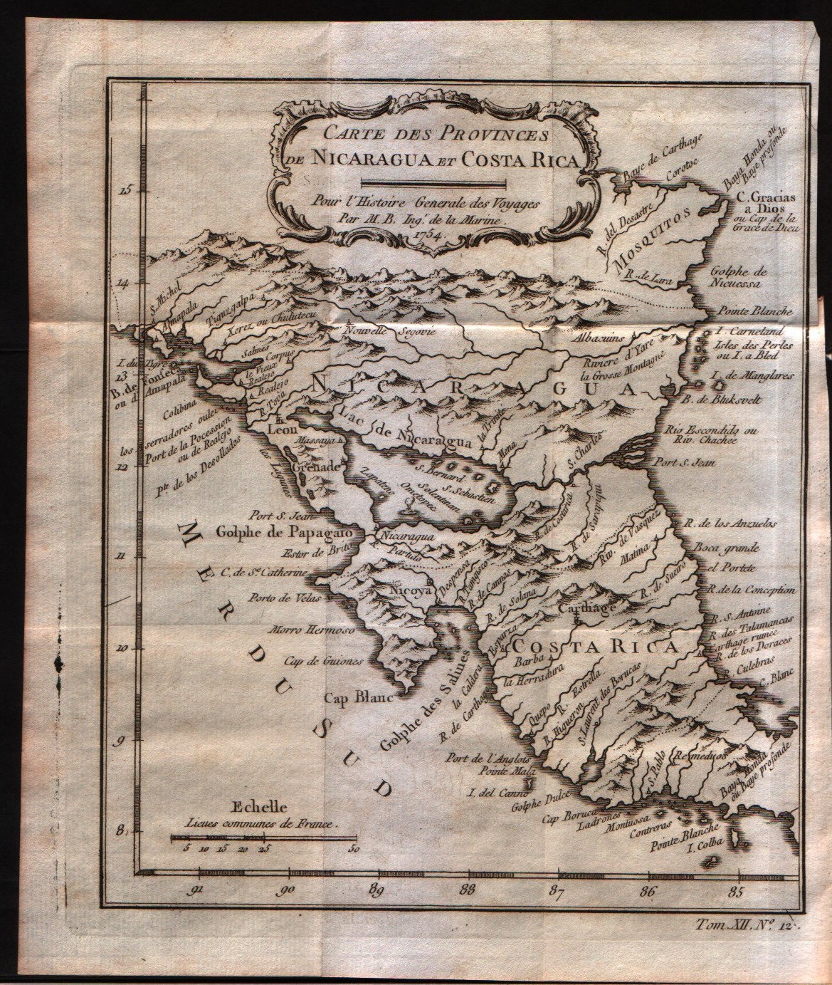
Map title
Carte des provinces de Nicaragua et Costa Rica
Author
Bellin
Location shown in map
Nicaragua and Costa Rica
Edition date
1757
Edition place
Paris
Editor
--
Atlas
Historie General des Voyages -- Prevost
Price
Please ask: info@thetreasuremaps.com
State
[mint/EXCELLENT/very good/good/fair/mediocre/poor]
Color
Black/white
Verso
Blank
Size
Plate: cm (16.5 x 20.3) inches (6.5 x 7.99) Paper: cm (19 x 22.9) inches (7.48 x 9.02)
Technique
Copper engraving
Note
No particular notes for this maps
Reference
--
Wiki
Here for more info
In stock
Available
Info
info@thetreasuremaps.com
Code
#0350
×
![Carte des provinces de Nicaragua et Costa Rica by Bellin, Nicaragua and Costa Rica, 1757]()
Map title
Carte de l'isthme de Panama et des des provinces de Veragua Terre Ferme et Darien
Author
Bellin
Location shown in map
Panama
Edition date
1757
Edition place
Paris
Editor
--
Atlas
Historie General des Voyages -- Prevost
Price
Please ask: info@thetreasuremaps.com
State
[mint/EXCELLENT/very good/good/fair/mediocre/poor]
Color
Black/white
Verso
Blank
Size
Plate: cm (27.9 x 20.3) inches (10.98 x 7.99) Paper: cm (31.8 x 22.9) inches (12.52 x 9.02)
Technique
Copper engraving
Note
No particular notes for this maps
Reference
--
Wiki
Here for more info
In stock
Available
Info
info@thetreasuremaps.com
Code
#0351
×
![Carte de l'isthme de Panama et des des provinces de Veragua Terre Ferme et Darien by Bellin, Panama, 1757]()
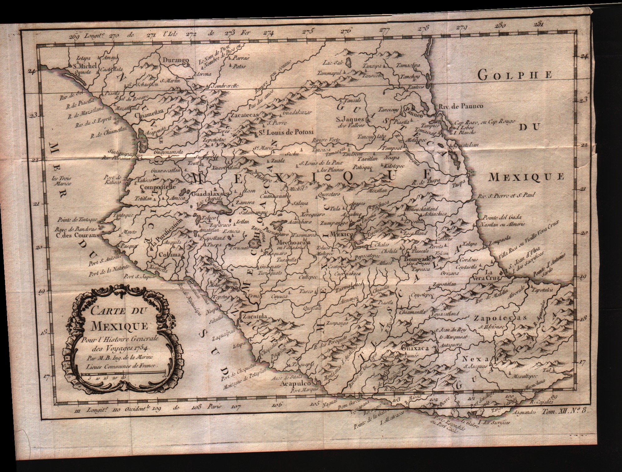
Map title
Carte du Mexique
Author
Bellin
Location shown in map
Mexico
Edition date
1757
Edition place
Paris
Editor
--
Atlas
Historie General des Voyages -- Prevost
Price
Please ask: info@thetreasuremaps.com
State
[mint/EXCELLENT/very good/good/fair/mediocre/poor]
Color
Black/white
Verso
Blank
Size
Plate: cm (29.2 x 20.3) inches (11.5 x 7.99) Paper: cm (31.8 x 22.9) inches (12.52 x 9.02)
Technique
Copper engraving
Note
No particular notes for this maps
Reference
--
Wiki
Here for more info
In stock
Available
Info
info@thetreasuremaps.com
Code
#0352
×
![Carte du Mexique by Bellin, Mexico, 1757]()
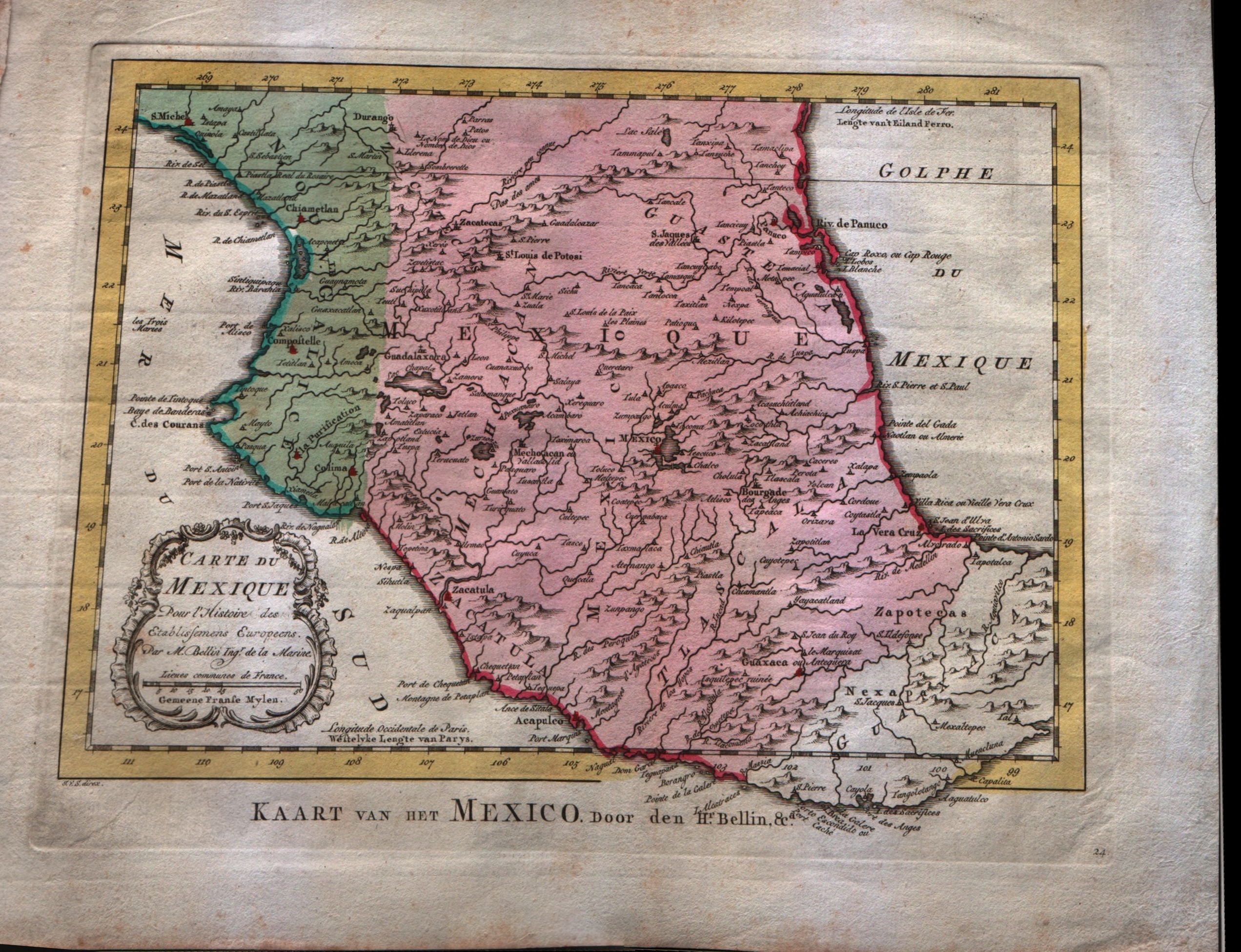
Map title
Carte du Mexique
Author
Bellin
Location shown in map
Mexico
Edition date
1773
Edition place
Amsterdam
Editor
--
Atlas
Atlas Portatif -- E. van Harrevelt
Price
Please ask: info@thetreasuremaps.com
State
[mint/EXCELLENT/very good/good/fair/mediocre/poor]
Color
Old colors
Verso
Blank
Size
Plate: cm (36.8 x 26.7) inches (14.49 x 10.51) Paper: cm (29.2 x 21.6) inches (11.5 x 8.5)
Technique
Copper engraving
Note
No particular notes for this maps
Reference
--
Wiki
Here for more info
In stock
Available
Info
info@thetreasuremaps.com
Code
#0358
×
![Carte du Mexique by Bellin, Mexico, 1773]()
Map title
Carte des environs de la ville de Mexico
Author
Bellin
Location shown in map
Map of Mexico city
Edition date
1773
Edition place
Amsterdam
Editor
--
Atlas
Atlas Portatif -- E. van Harrevelt
Price
Please ask: info@thetreasuremaps.com
State
[mint/EXCELLENT/very good/good/fair/mediocre/poor]
Color
Old colors
Verso
Blank
Size
Plate: cm (21.6 x 26.7) inches (8.5 x 10.51) Paper: cm (16.5 x 20.3) inches (6.5 x 7.99)
Technique
Copper engraving
Note
No particular notes for this maps
Reference
--
Wiki
Here for more info
In stock
Sold
Info
info@thetreasuremaps.com
Code
#0359
×
![Carte des environs de la ville de Mexico by Bellin, Map of Mexico city, 1773]()