Eastern Europe
Map title
Prag area
Author
Munster
Location shown in map
Prag area
Edition date
1560
Edition place
???
Editor
Henrich Petri
Atlas
Cosmographia Universalis
Price
Please ask: info@thetreasuremaps.com
State
[mint/EXCELLENT/very good/good/fair/mediocre/poor]
Color
Black/white
Verso
German text
Size
Plate: cm (8.9 x 14) inches (3.5 x 5.51) Paper: cm (44.4 x 29.2) inches (17.48 x 11.5)
Technique
Woodcut
Note
No particular notes for this maps
Reference
--
Wiki
Here for more info
In stock
Available
Info
info@thetreasuremaps.com
Code
#0098
Prag area
Author
Munster
Location shown in map
Prag area
Edition date
1560
Edition place
???
Editor
Henrich Petri
Atlas
Cosmographia Universalis
Price
Please ask: info@thetreasuremaps.com
State
[mint/EXCELLENT/very good/good/fair/mediocre/poor]
Color
Black/white
Verso
German text
Size
Plate: cm (8.9 x 14) inches (3.5 x 5.51) Paper: cm (44.4 x 29.2) inches (17.48 x 11.5)
Technique
Woodcut
Note
No particular notes for this maps
Reference
--
Wiki
Here for more info
In stock
Available
Info
info@thetreasuremaps.com
Code
#0098
×
![]()
Map title
Tavola nuova di Prussia et di Livonia
Author
Ruscelli
Location shown in map
Poland
Edition date
1561
Edition place
Venice
Editor
Vincenzo Valgrisi
Atlas
La Geographia di Claudio Tolomeo
Price
Please ask: info@thetreasuremaps.com
State
[mint/excellent/very good/good/FAIR/mediocre/poor]
Color
Black/white
Verso
Italian text
Size
Plate: cm (26 x 20.3) inches (10.24 x 7.99) Paper: cm (30.5 x 22.9) inches (12.01 x 9.02)
Technique
Copper engraving
Note
Based on Gastaldi map.
Reference
--
Wiki
Here for more info
In stock
Sold
Info
info@thetreasuremaps.com
Code
#0116
×
![]()
Map title
Prussiae
Author
Ortelius
Location shown in map
Poland
Edition date
1588
Edition place
Antwerp
Editor
Atlas
Theatrum Orbis Terrarum
Price
350 Euro
State
[mint/excellent/very good/good/FAIR/mediocre/poor]
Color
Old colors
Verso
Spanish text
Size
Plate: cm (51 x 42) inches (20.08 x 16.54) Paper: cm (42 x 36) inches (16.54 x 14.17)
Technique
Copper engraving
Note
Reference
Van Den Broecke 206
Wiki
Here for more info
In stock
Available
Info
info@thetreasuremaps.com
Code
#1187
×
![]()
Map title
Hungaria
Author
Mercator
Location shown in map
Hungary
Edition date
1606
Edition place
Amsterdam
Editor
--
Atlas
Mercator-Hondius Atlas.
Price
200 Euro
State
[mint/excellent/very good/GOOD/fair/mediocre/poor]
Color
Black/white
Verso
French text
Size
Plate: cm (41.9 x 36.8) inches (16.5 x 14.49) Paper: cm (55.9 x 45.7) inches (22.01 x 17.99)
Technique
Copper engraving
Note
No particular notes for this maps
Reference
--
Wiki
Here for more info
In stock
Available
Info
info@thetreasuremaps.com
Code
#0130
×
![]()
Map title
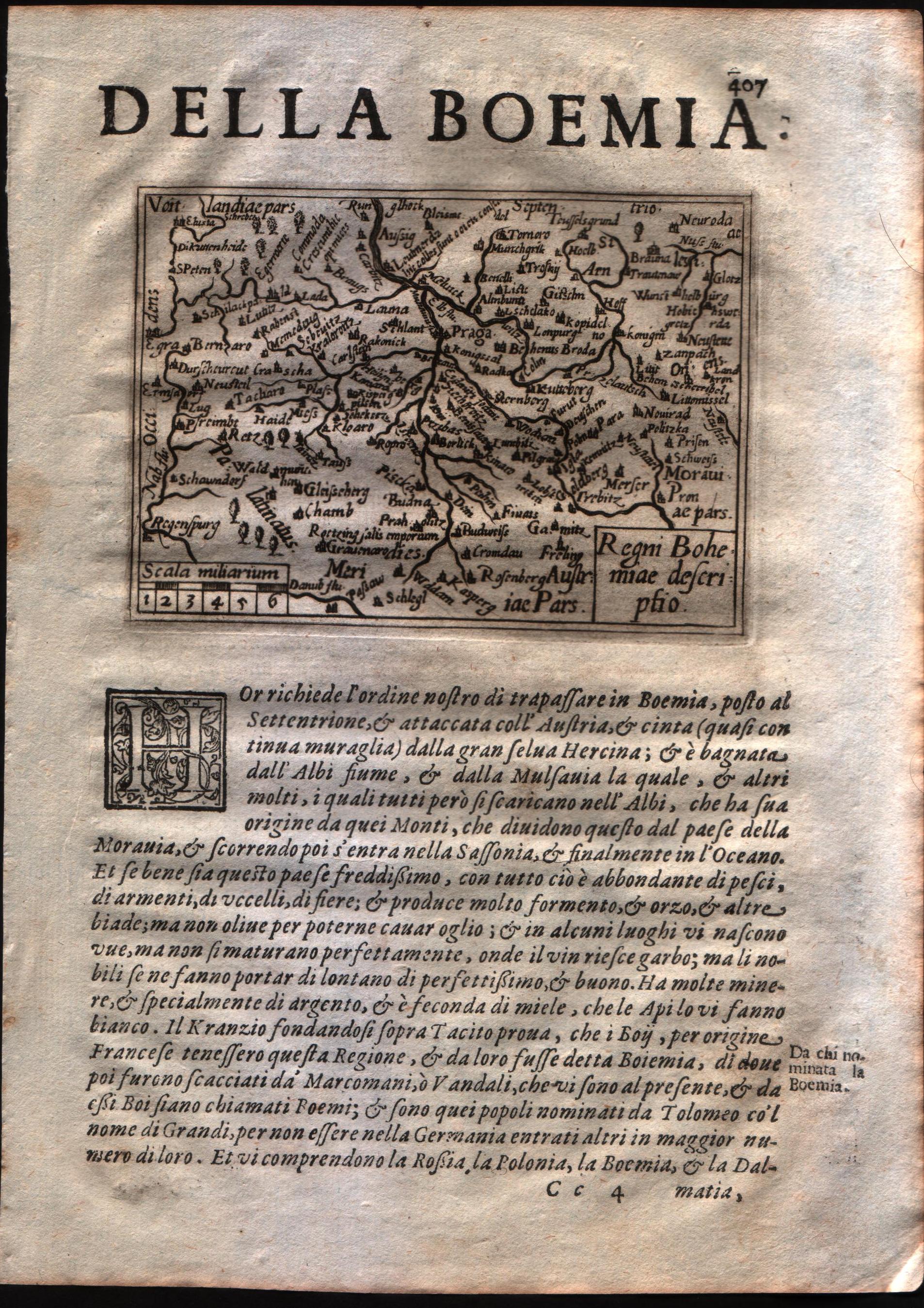
Regni Bohemie descriptio
Author
Doglioni
Location shown in map
Boemia
Edition date
1623
Edition place
Venice
Editor
Giacomo Sarzina
Atlas
Anfiteatro di Europa
Price
Please ask: info@thetreasuremaps.com
State
[mint/EXCELLENT/very good/good/fair/mediocre/poor]
Color
Black/white
Verso
Italian text pag.407
Size
Plate: cm (11.4 x 8.9) inches (4.49 x 3.5) Paper: cm (15.2 x 22.9) inches (5.98 x 9.02)
Technique
Copper engraving
Note
The maps are copies of the Galle (c.1595) edition of Ortelius.
Reference
--
Wiki
Here for more info
In stock
Available
Info
info@thetreasuremaps.com
Code
#0587
×
![]()
Map title
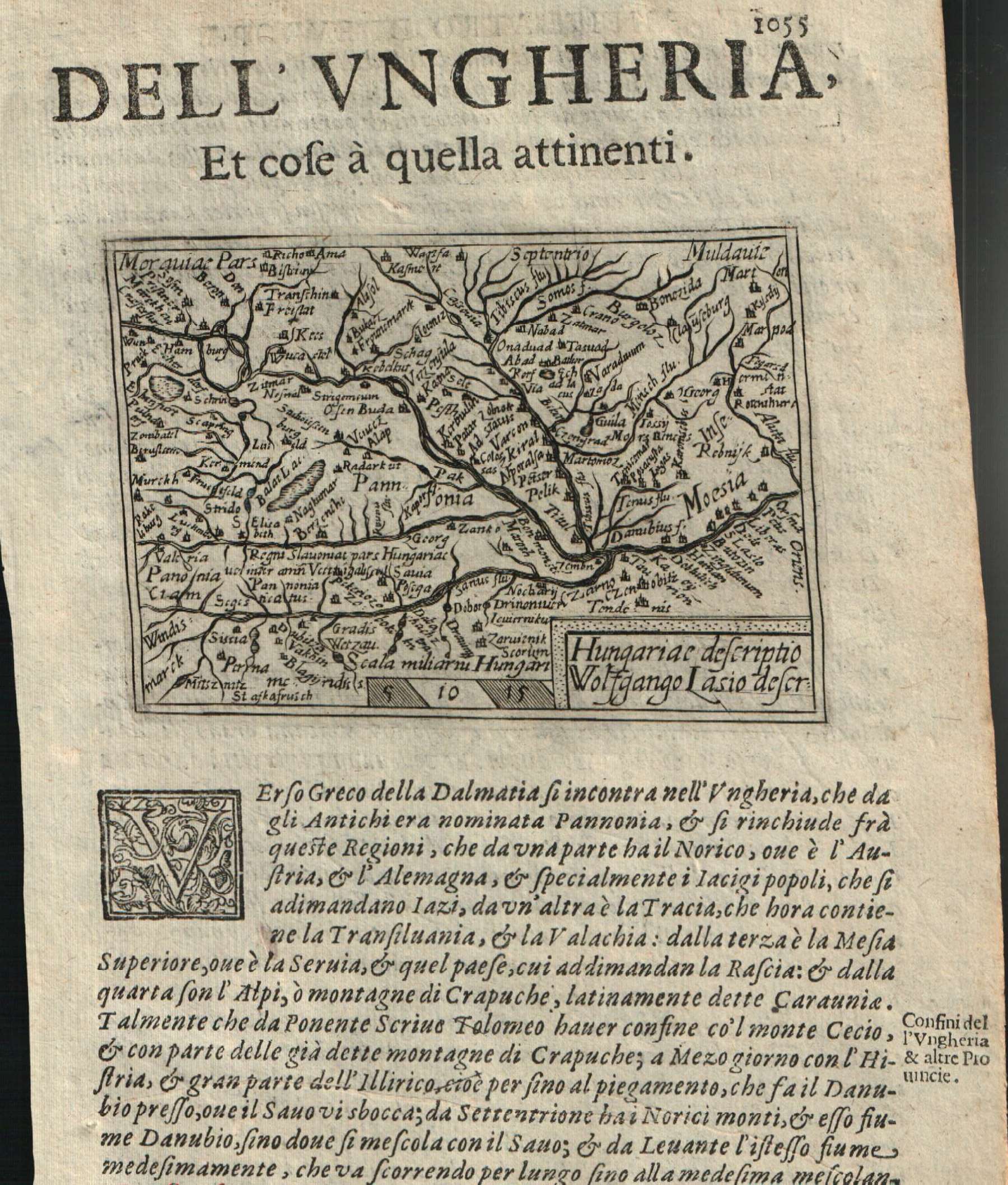
Hungaric descriptio
Author
Doglioni
Location shown in map
Hungary
Edition date
1623
Edition place
Venice
Editor
Giacomo Sarzina
Atlas
Anfiteatro di Europa
Price
Please ask: info@thetreasuremaps.com
State
[mint/EXCELLENT/very good/good/fair/mediocre/poor]
Color
Black/white
Verso
Italian text pag.1056
Size
Plate: cm (11.4 x 8.9) inches (4.49 x 3.5) Paper: cm (15.2 x 22.9) inches (5.98 x 9.02)
Technique
Copper engraving
Note
The maps are copies of the Galle (c.1595) edition of Ortelius.
Reference
--
Wiki
Here for more info
In stock
Available
Info
info@thetreasuremaps.com
Code
#0617
×
![]()
Map title
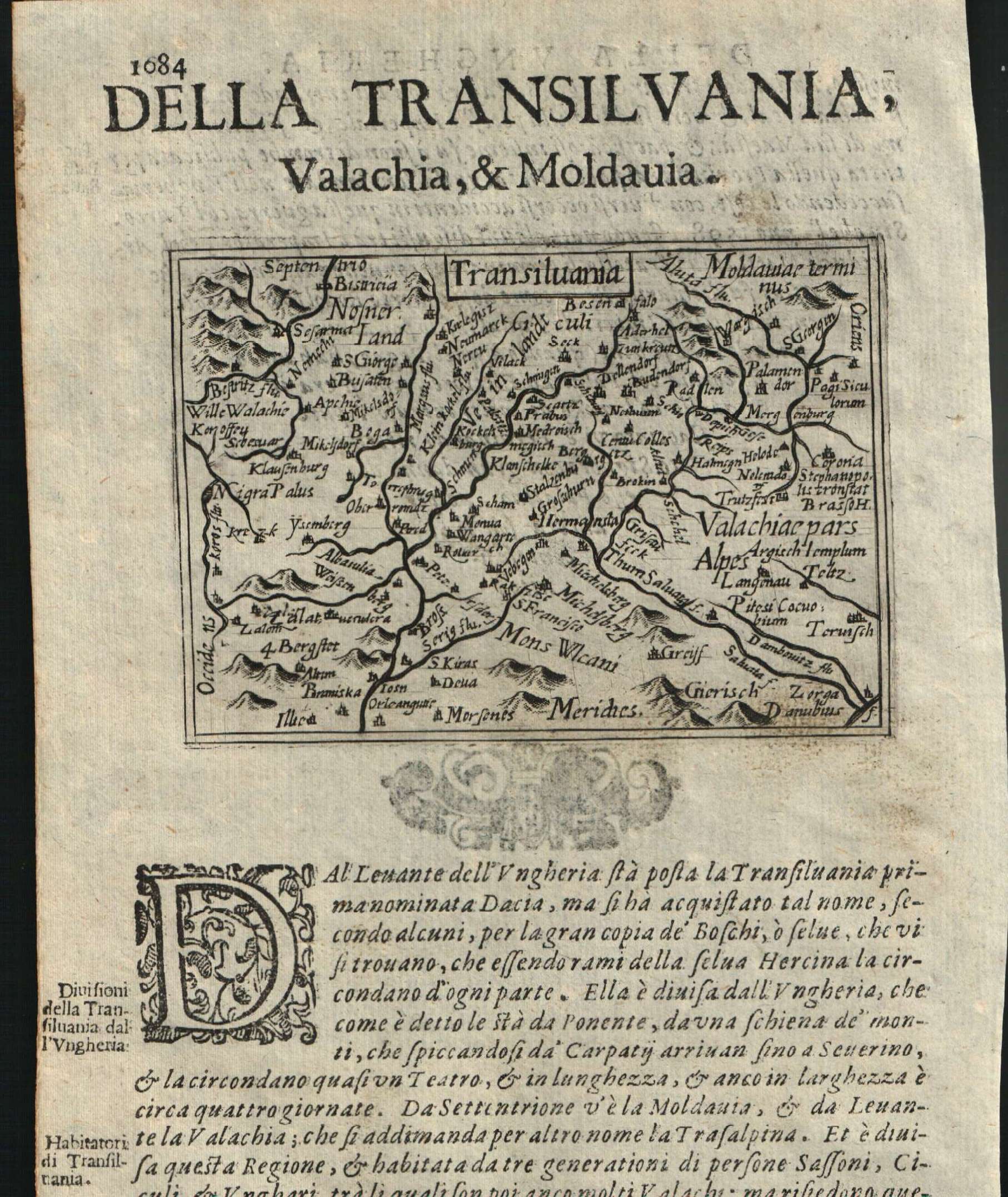
Transilvania
Author
Doglioni
Location shown in map
Transylvania
Edition date
1623
Edition place
Venice
Editor
Giacomo Sarzina
Atlas
Anfiteatro di Europa
Price
Please ask: info@thetreasuremaps.com
State
[mint/EXCELLENT/very good/good/fair/mediocre/poor]
Color
Black/white
Verso
Italian text pag.1083
Size
Plate: cm (11.4 x 8.9) inches (4.49 x 3.5) Paper: cm (15.2 x 22.9) inches (5.98 x 9.02)
Technique
Copper engraving
Note
The maps are copies of the Galle (c.1595) edition of Ortelius.
Reference
--
Wiki
Here for more info
In stock
Available
Info
info@thetreasuremaps.com
Code
#0616
×
![]()
Map title
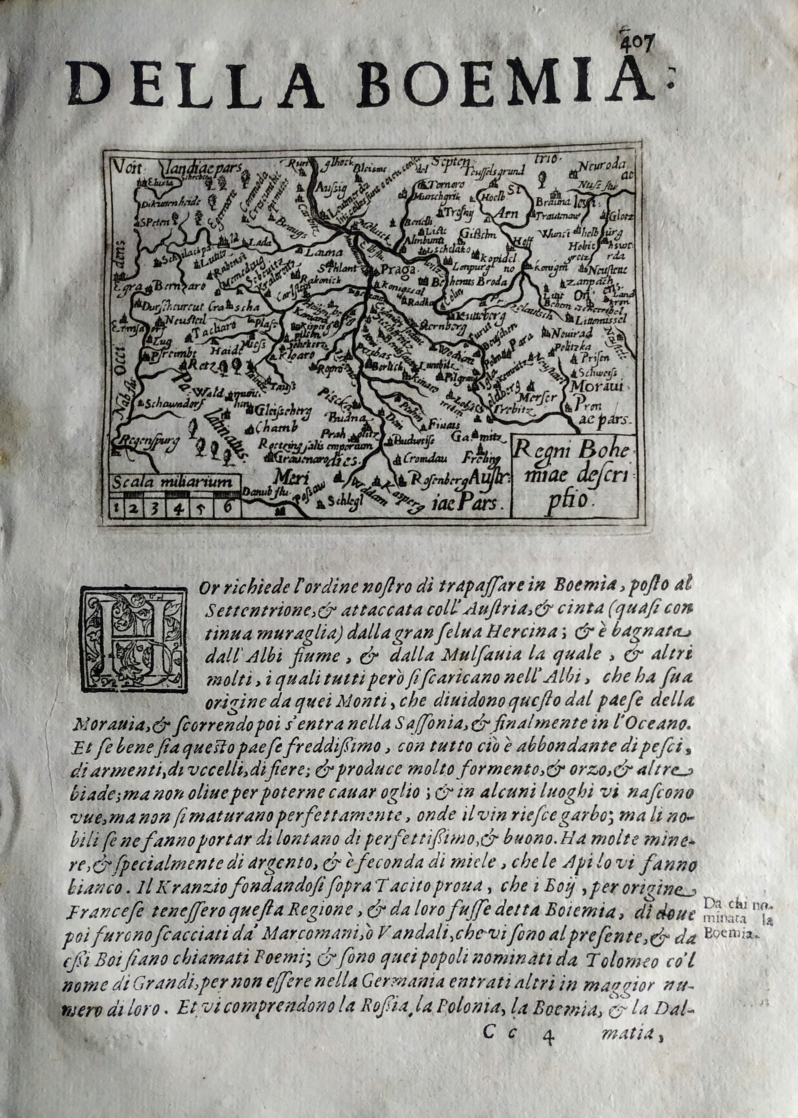
Regni Bohemie descriptio
Author
Doglioni
Location shown in map
Boemia
Edition date
1623
Edition place
Venice
Editor
Giacomo Sarzina
Atlas
Anfiteatro di Europa
Price
Please ask: info@thetreasuremaps.com
State
[mint/EXCELLENT/very good/good/fair/mediocre/poor]
Color
Black/white
Verso
Italian text pag.407
Size
Plate: cm (11.4 x 8.9) inches (4.49 x 3.5) Paper: cm (15.2 x 22.9) inches (5.98 x 9.02)
Technique
Copper engraving
Note
The maps are copies of the Galle (c.1595) edition of Ortelius.
Reference
--
Wiki
Here for more info
In stock
Available
Info
info@thetreasuremaps.com
Code
#0771
×
![]()
Map title
Partie de Lithuanie
Author
Sanson
Location shown in map
Lituania
Edition date
1665
Edition place
Paris
Editor
Atlas
Price
500 Euro
State
[mint/excellent/very good/good/FAIR/mediocre/poor]
Color
Old colors
Verso
Blank
Size
Plate: cm (56 x 41) inches (22.05 x 16.14) Paper: cm (60 x 46) inches (23.62 x 18.11)
Technique
Copper engraving
Note
Reference
Wiki
Here for more info
In stock
Available
Info
info@thetreasuremaps.com
Code
#1191
×
![]()
Map title
Bohemia regnum
Author
Seutter, Matthaus
Location shown in map
Bohemia
Edition date
1730
Edition place
Augsburg
Editor
--
Atlas
--
Price
Please ask: info@thetreasuremaps.com
State
[mint/excellent/very good/GOOD/fair/mediocre/poor]
Color
Old color
Verso
Blank
Size
Plate: cm (55.9 x 49.5) inches (22.01 x 19.49) Paper: cm (58.4 x 52.1) inches (22.99 x 20.51)
Technique
Copper engraving
Note
No particular notes for this maps
Reference
--
Wiki
Here for more info
In stock
Available
Info
info@thetreasuremaps.com
Code
#0148
×
![]()
Map title
Le Royaume de Pologne
Author
Robert de Vaugondy
Location shown in map
Poland
Edition date
Circa 1776
Edition place
Venice
Editor
Santini
Atlas
Atlas Universel
Price
250 Euro
State
[mint/EXCELLENT/very good/good/fair/mediocre/poor]
Color
Old colors
Verso
Blank
Size
Plate: cm (61 x 48) inches (24.02 x 18.9) Paper: cm (72 x 53) inches (28.35 x 20.87)
Technique
Copper engraving
Note
Reference
Wiki
Here for more info
In stock
Available
Info
info@thetreasuremaps.com
Code
#1070
×
![]()

Map title
Royaume de Hongrie
Author
Unknown
Location shown in map
Hungary
Edition date
1784
Edition place
Venise
Editor
--
Atlas
Atlas Universel dresse sur les meilleures cartes modernes. Printed by Santini & Remondini.
Price
Please ask: info@thetreasuremaps.com
State
[mint/EXCELLENT/very good/good/fair/mediocre/poor]
Color
Old outlined
Verso
Blank
Size
Plate: cm (48.3 x 68.6) inches (19.02 x 27.01) Paper: cm (54.6 x 76.2) inches (21.5 x 30)
Technique
Copper engraving
Note
The atlas is effectively an Italian copy of the Robert de Vaugondy Atlas Universel, and contains 123 maps, variously dated 1775 to 1780. The atlas was reprinted in 1784 by Remondini, which gives a relatively short career span for Santini.
Reference
--
Wiki
Here for more info
In stock
Sold
Info
info@thetreasuremaps.com
Code
#0442
×
![]()
Map title
Hungaria
Author
Unknown
Location shown in map
Hungary
Edition date
1885
Edition place
Gotha
Editor
--
Atlas
Hand atlas
Price
Please ask: info@thetreasuremaps.com
State
[mint/EXCELLENT/very good/good/fair/mediocre/poor]
Color
Old outlined
Verso
Blank
Size
Plate: cm (40.6 x 33) inches (15.98 x 12.99) Paper: cm (48.3 x 38.1) inches (19.02 x 15)
Technique
--
Note
No particular notes for this maps
Reference
--
Wiki
Here for more info
In stock
Sold
Info
info@thetreasuremaps.com
Code
#0500
×
![]()