Far East
Map title
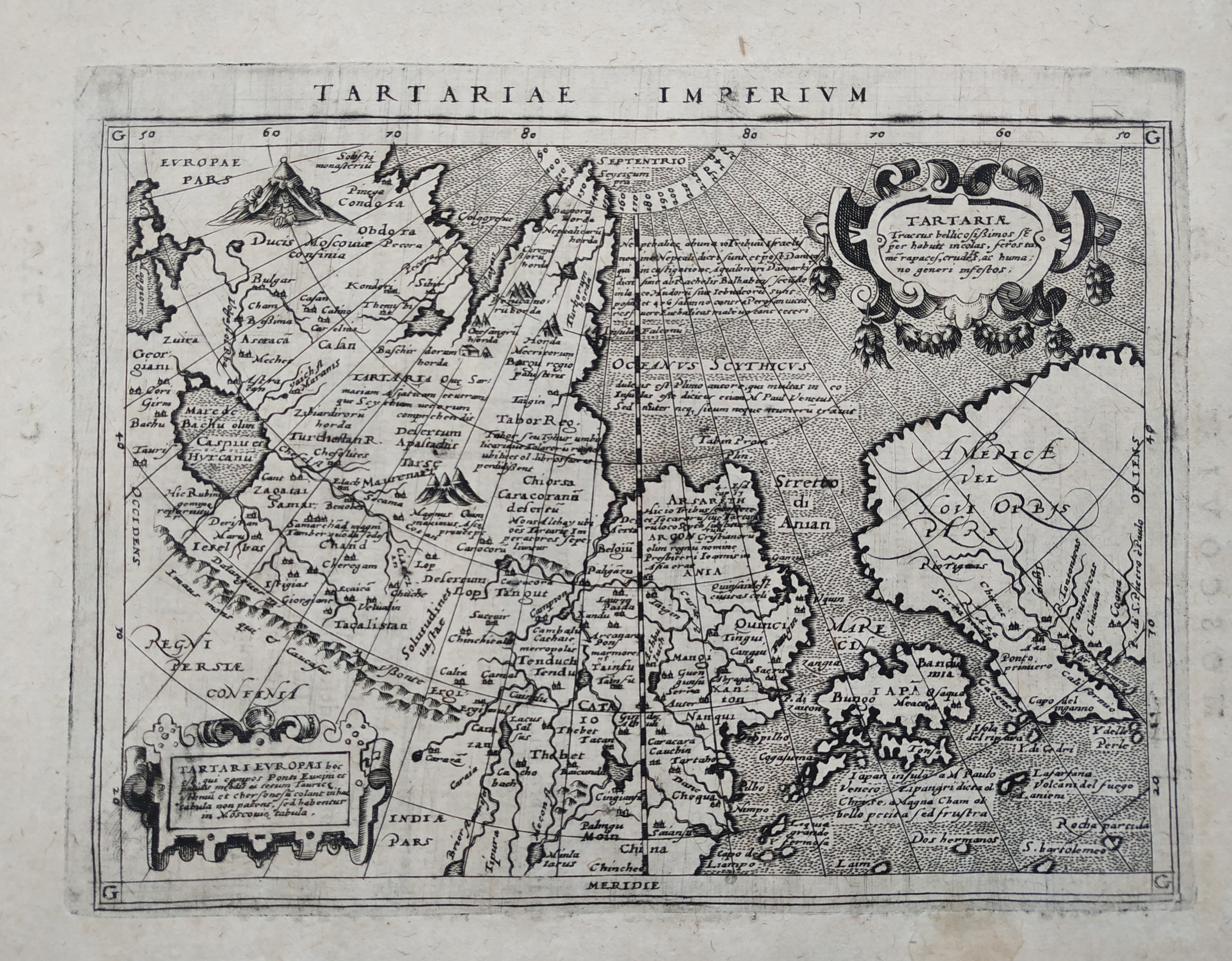
Tartariae Imperium
Author
Magini
Location shown in map
Russia
Edition date
1597
Edition place
Cologne
Editor
Petrus Keschedt
Atlas
Geografia di Claudio Tolomeo -- Giovanni Antonio Magini
Price
Please ask: info@thetreasuremaps.com
State
[mint/EXCELLENT/very good/good/fair/mediocre/poor]
Color
Black/white
Verso
Latin text pag 229
Size
Plate: cm (18 x 13.5) inches (7.09 x 5.31) Paper: cm (23 x 17) inches (9.06 x 6.69)
Technique
Copper engraving
Note
Maps pirated from those of Girolamo Poro in Magini's edition.
Reference
--
Wiki
Here for more info
In stock
Available
Info
info@thetreasuremaps.com
Code
#0833
×
![Tartariae Imperium by Magini, Russia, 1597]()
Map title
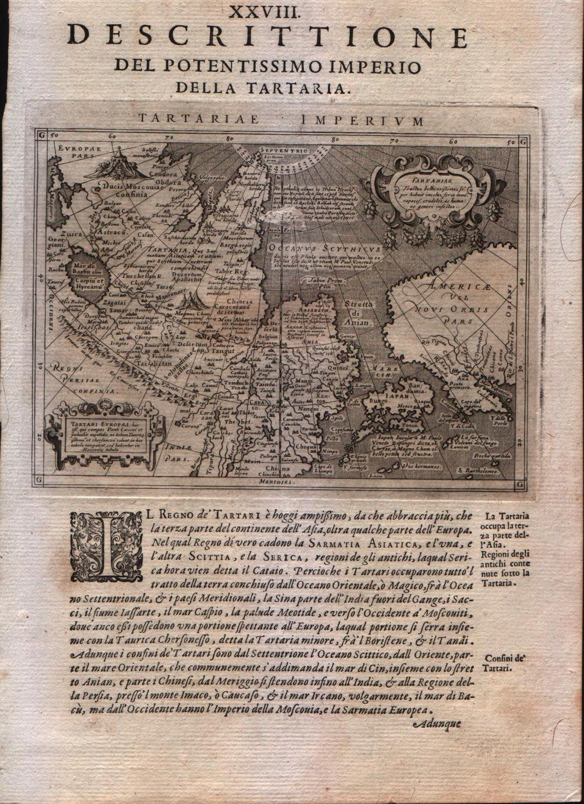
Descrittione del potentissimo imperio della Tartaria
Author
Magini
Location shown in map
East Asia, Japan, California
Edition date
1598
Edition place
Venice
Editor
Battista & Giorgio Galignani
Atlas
Geografia di Claudio Tolomeo -- Giovanni Antonio Magini
Price
350 Euro
State
[MINT/excellent/very good/good/fair/mediocre/poor]
Color
Black/white
Verso
Italian text
Size
Plate: cm (12.7 x 17.8) inches (5 x 7.01) Paper: cm (20.3 x 30.5) inches (7.99 x 12.01)
Technique
Copper engraving
Note
Very interesting map of East Asia and North West America.
Reference
--
Wiki
Here for more info
In stock
Available
Info
info@thetreasuremaps.com
Code
#0208
×
![Descrittione del potentissimo imperio della Tartaria by Magini, East Asia, Japan, California, 1598]()
Map title
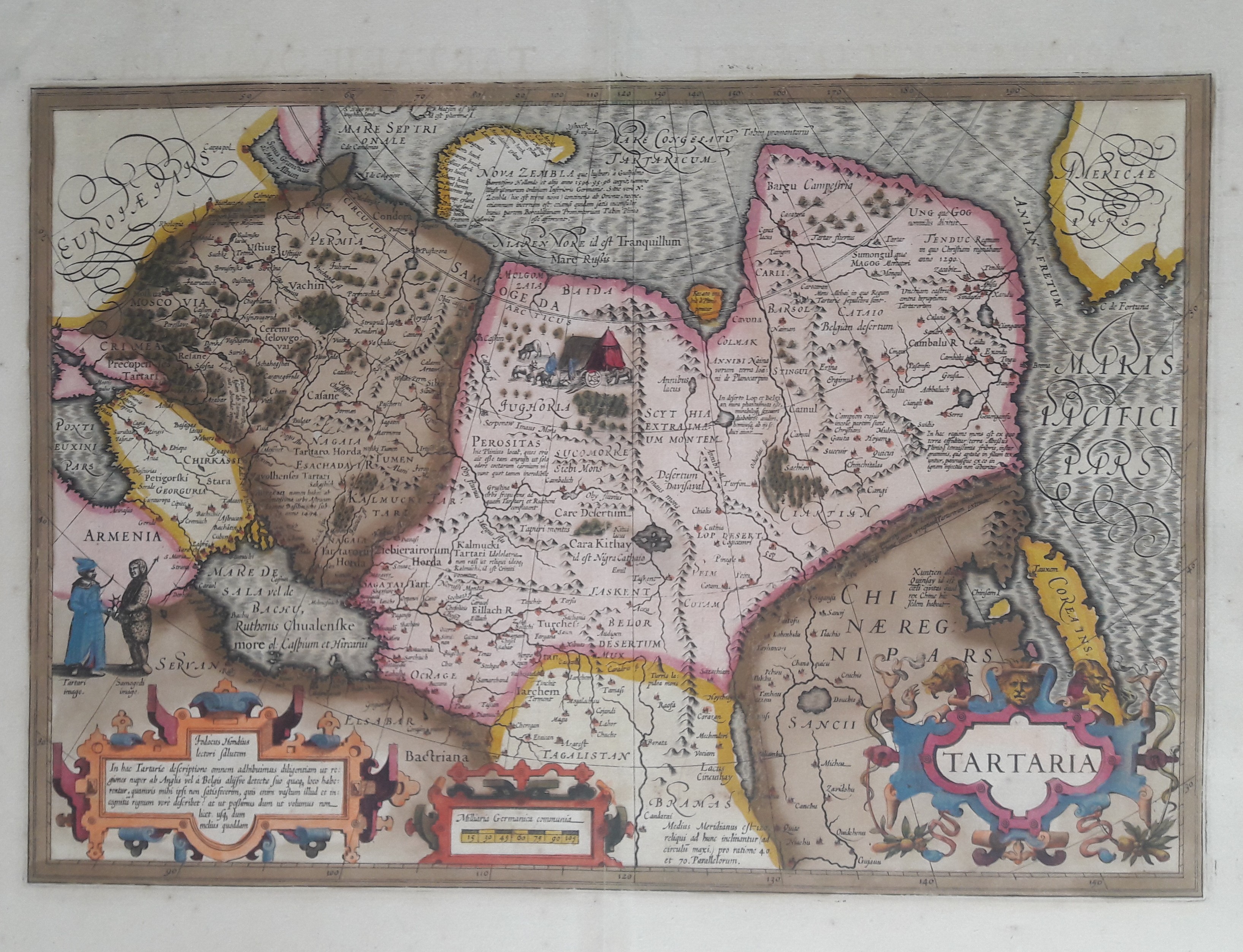
Tartaria
Author
Hondius
Location shown in map
Russia
Edition date
1606
Edition place
Amsterdam
Editor
Atlas
Atlas Maioris
Price
600 Euro
State
[mint/EXCELLENT/very good/good/fair/mediocre/poor]
Color
Old colors
Verso
Franch text 336
Size
Plate: cm (49 x 33) inches (19.29 x 12.99) Paper: cm (58 x 47) inches (22.83 x 18.5)
Technique
Copper engraving
Note
Professionally repaired
Reference
Wiki
Here for more info
In stock
Available
Info
info@thetreasuremaps.com
Code
#0656
×
![Tartaria by Hondius, Russia, 1606]()

Map title
Japonia
Author
Hondius
Location shown in map
Japan
Edition date
Circa 1611
Edition place
Amsterdam
Editor
Hondius
Atlas
Atlas sive Cosmographicae Meditationes de Fabrica Mundi et Fabricati Figura.
Price
1600 Euro
State
[mint/EXCELLENT/very good/good/fair/mediocre/poor]
Color
Old colors
Verso
Latin pag 360
Size
Plate: cm (45 x 35) inches (17.72 x 13.78) Paper: cm (54 x 42) inches (21.26 x 16.54)
Technique
Copper engraving
Note
Reference
Wiki
Here for more info
In stock
Available
Info
info@thetreasuremaps.com
Code
#1343
×
![Japonia by Hondius, Japan, Circa 1611]()
Map title
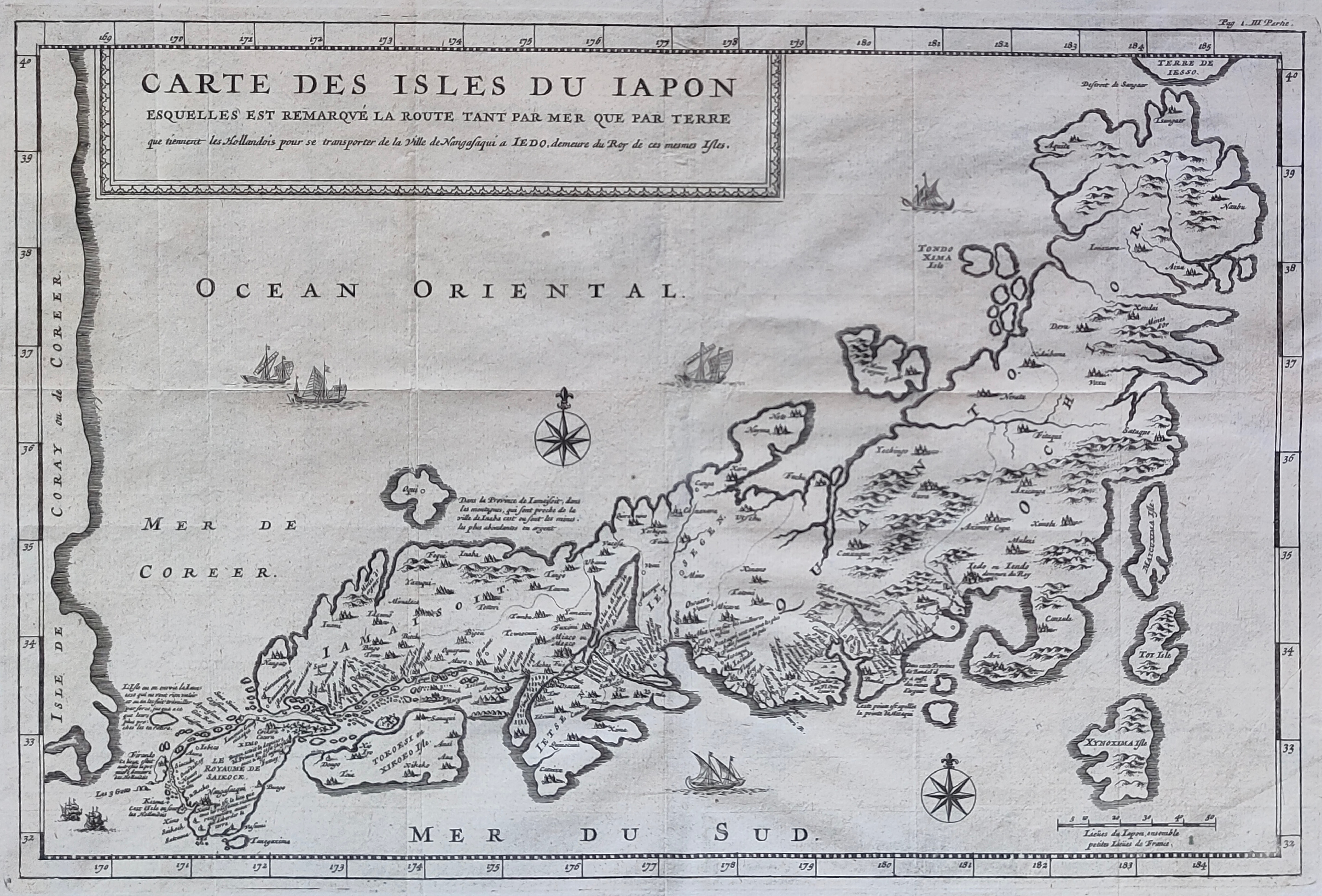
Carte des isles du Japon
Author
Tavernier
Location shown in map
Japan
Edition date
Circa 1679
Edition place
Paris
Editor
Atlas
Price
400 Euro
State
[mint/EXCELLENT/very good/good/fair/mediocre/poor] repaired
Color
Black/white
Verso
Blank
Size
Plate: cm (33 x 21) inches (12.99 x 8.27) Paper: cm (35 x 24) inches (13.78 x 9.45)
Technique
Copper engraving
Note
Reference
Wiki
Here for more info
In stock
Available
Info
info@thetreasuremaps.com
Code
#1201
×
![Carte des isles du Japon by Tavernier, Japan, Circa 1679]()
Map title
La gran Tartaria
Author
Cantelli da Vignola
Location shown in map
Tartaria
Edition date
1689
Edition place
Rome
Editor
De Rossi
Atlas
Mercurio Geografico
Price
700 Euro
State
[mint/EXCELLENT/very good/good/fair/mediocre/poor]
Color
Old colors
Verso
Blank
Size
Plate: cm (53 x 43) inches (20.87 x 16.93) Paper: cm (60 x 45) inches (23.62 x 17.72)
Technique
Copper engraving
Note
Reference
Wiki
Here for more info
In stock
Available
Info
info@thetreasuremaps.com
Code
#1316
×
![La gran Tartaria by Cantelli da Vignola, Tartaria, 1689]()
Map title
Nuova carta della Tartaria
Author
Tirion
Location shown in map
East Asia
Edition date
1740
Edition place
Amsterdam
Editor
--
Atlas
Atlante Novissimo. Giambattista Albrizzi
Price
150 Euro
State
[mint/excellent/VERY GOOD/good/fair/mediocre/poor]
Color
Black/white
Verso
Blank
Size
Plate: cm (33 x 27.9) inches (12.99 x 10.98) Paper: cm (48.3 x 38.1) inches (19.02 x 15)
Technique
Copper engraving
Note
No particular notes for this maps
Reference
--
Wiki
Here for more info
In stock
Available
Info
info@thetreasuremaps.com
Code
#0222
×
![Nuova carta della Tartaria by Tirion, East Asia, 1740]()
Map title
Carta accurata dell'impero del Giappone
Author
Tirion
Location shown in map
Japan
Edition date
Circa 1740
Edition place
Venice
Editor
--
Atlas
--
Price
300 Euro
State
MINT/excellent/very good/good/fair/mediocre/poor]
Color
Black/white
Verso
Blank
Size
Plate: cm (32 x 26) inches (12.6 x 10.24) Paper: cm (33 x 27) inches (12.99 x 10.63)
Technique
Copper engraving
Note
Framed
Reference
--
Wiki
Here for more info
In stock
Available
Info
info@thetreasuremaps.com
Code
#1126
×
![Carta accurata dell'impero del Giappone by Tirion, Japan, Circa 1740]()
Map title
Carte De L'Empire Du Japon
Author
Bellin
Location shown in map
Japan
Edition date
1757
Edition place
Paris
Editor
--
Atlas
Historie General des Voyages -- Prevost
Price
450 Euro
State
[mint/EXCELLENT/very good/good/fair/mediocre/poor]
Color
Black/white
Verso
Blank
Size
Plate: cm (31.1 x 21.6) inches (12.24 x 8.5) Paper: cm (31.1 x 22.9) inches (12.24 x 9.02)
Technique
Copper engraving
Note
No particular notes for this maps
Reference
--
Wiki
Here for more info
In stock
Available
Info
info@thetreasuremaps.com
Code
#0807
×
![Carte De L'Empire Du Japon by Bellin, Japan, 1757]()

Map title
Plan du Port et de la Ville de Nangasaki
Author
Bellin
Location shown in map
Japan
Edition date
1757
Edition place
Paris
Editor
--
Atlas
Historie General des Voyages -- Prevost
Price
Please ask: info@thetreasuremaps.com
State
[mint/EXCELLENT/very good/good/fair/mediocre/poor]
Color
Black/white
Verso
Blank
Size
Plate: cm (35.6 x 21.6) inches (14.02 x 8.5) Paper: cm (33 x 20.3) inches (12.99 x 7.99)
Technique
Copper engraving
Note
No particular notes for this maps
Reference
--
Wiki
Here for more info
In stock
Sold
Info
info@thetreasuremaps.com
Code
#0376
×
![Plan du Port et de la Ville de Nangasaki by Bellin, Japan, 1757]()
Map title
Plan de Jedo
Author
Bellin
Location shown in map
Japan
Edition date
1757
Edition place
Paris
Editor
--
Atlas
Historie General des Voyages -- Prevost
Price
Please ask: info@thetreasuremaps.com
State
[mint/EXCELLENT/very good/good/fair/mediocre/poor]
Color
Black/white
Verso
Blank
Size
Plate: cm (26.7 x 25.4) inches (10.51 x 10) Paper: cm (24.1 x 24.1) inches (9.49 x 9.49)
Technique
Copper engraving
Note
Map of Tokyo
Reference
--
Wiki
Here for more info
In stock
Sold
Info
info@thetreasuremaps.com
Code
#0375
×
![Plan de Jedo by Bellin, Japan, 1757]()
Map title
Carte De L'Empire Du Japon
Author
Bellin
Location shown in map
Japan
Edition date
1757
Edition place
Paris
Editor
--
Atlas
Historie General des Voyages -- Prevost
Price
Please ask: info@thetreasuremaps.com
State
[mint/excellent/VERY GOOD/good/fair/mediocre/poor]
Color
Black/white
Verso
Blank
Size
Plate: cm (31.1 x 21.6) inches (12.24 x 8.5) Paper: cm (31.1 x 22.9) inches (12.24 x 9.02)
Technique
Copper engraving
Note
No particular notes for this maps
Reference
--
Wiki
Here for more info
In stock
Sold
Info
info@thetreasuremaps.com
Code
#0249
×
![Carte De L'Empire Du Japon by Bellin, Japan, 1757]()
Map title
Carte de la Province de Quan-tong ou Lyau-tong et du Royaume de Kau-li ou Coree
Author
Bellin
Location shown in map
Korea
Edition date
1757
Edition place
Paris
Editor
--
Atlas
Historie General des Voyages -- Prevost
Price
Please ask: info@thetreasuremaps.com
State
[mint/excellent/VERY GOOD/good/fair/mediocre/poor]
Color
Black/white
Verso
Blank
Size
Plate: cm (21.6 x 26.7) inches (8.5 x 10.51) Paper: cm (22.9 x 27.9) inches (9.02 x 10.98)
Technique
Copper engraving
Note
No particular notes for this maps
Reference
--
Wiki
Here for more info
In stock
Sold
Info
info@thetreasuremaps.com
Code
#0240
×
![Carte de la Province de Quan-tong ou Lyau-tong et du Royaume de Kau-li ou Coree by Bellin, Korea, 1757]()
Map title
Carte des isles du Japon et la peresqu'isle de Coree avec les costes de la Chine depuis Pekin jusqua Canton
Author
Bellin
Location shown in map
Japan
Edition date
1757
Edition place
Paris
Editor
--
Atlas
Historie General des Voyages -- Prevost
Price
250 Euro
State
[mint/EXCELLENT/very good/good/fair/mediocre/poor]
Color
Black/white
Verso
Blank
Size
Plate: cm (27.9 x 21.6) inches (10.98 x 8.5) Paper: cm (30.5 x 22.9) inches (12.01 x 9.02)
Technique
Copper engraving
Note
No particular notes for this maps
Reference
--
Wiki
Here for more info
In stock
Available
Info
info@thetreasuremaps.com
Code
#0239
×
![Carte des isles du Japon et la peresqu'isle de Coree avec les costes de la Chine depuis Pekin jusqua Canton by Bellin, Japan, 1757]()
Map title
Nuove scoperte dei russi al nord del mare del sud
Author
Zatta
Location shown in map
Tartaria
Edition date
1776
Edition place
Venice
Editor
Atlas
Atlante novissimo, illustrato ed accresciuto sulle osservazioni e scoperte fatte dai più celebri e più recenti geografi
Price
600 Euro
State
[mint/EXCELLENT/very good/good/fair/mediocre/poor]
Color
Old colors
Verso
Blank
Size
Plate: cm (40 x 30) inches (15.75 x 11.81) Paper: cm (50 x 38) inches (19.69 x 14.96)
Technique
Copper engraving
Note
Reference
Wiki
Here for more info
In stock
Available
Info
info@thetreasuremaps.com
Code
#1389
×
![Nuove scoperte dei russi al nord del mare del sud by Zatta, Tartaria, 1776]()
Map title
Les isles Philippines...
Author
Bonne
Location shown in map
South East
Edition date
1780
Edition place
Paris
Editor
--
Atlas
Atlas de toutes les parties connues du globe terrestre. J.L.Pellet
Price
Please ask: info@thetreasuremaps.com
State
[mint/EXCELLENT/very good/good/fair/mediocre/poor]
Color
Black/white
Verso
Blank
Size
Plate: cm (31.8 x 21.6) inches (12.52 x 8.5) Paper: cm (36.8 x 25.4) inches (14.49 x 10)
Technique
Copper engraving
Note
No particular notes for this maps
Reference
--
Wiki
Here for more info
In stock
Sold
Info
info@thetreasuremaps.com
Code
#0439
×
![Les isles Philippines... by Bonne, South East, 1780]()
Map title
Carte de la Coree et du Japon
Author
Brion de la Tour
Location shown in map
Japan
Edition date
Circa 1780
Edition place
Paris
Editor
Atlas
Price
200 Euro
State
[mint/EXCELLENT/very good/good/fair/mediocre/poor]
Color
Black/white
Verso
Blank
Size
Plate: cm (35 x 24) inches (13.78 x 9.45) Paper: cm (38 x 27) inches (14.96 x 10.63)
Technique
Copper engraving
Note
Reference
Wiki
Here for more info
In stock
Available
Info
info@thetreasuremaps.com
Code
#1322
×
![Carte de la Coree et du Japon by Brion de la Tour, Japan, Circa 1780]()
Map title
Giappone
Author
Location shown in map
Japan
Edition date
1820
Edition place
Milan
Editor
--
Atlas
Atlante Nuovo di Batelli & Fanfani
Price
Please ask: info@thetreasuremaps.com
State
[mint/EXCELLENT/very good/good/fair/mediocre/poor]
Color
Old outlined
Verso
Blank
Size
Plate: cm (24.1 x 20.3) inches (9.49 x 7.99) Paper: cm (45.7 x 27.9) inches (17.99 x 10.98)
Technique
--
Note
No particular notes for this maps
Reference
--
Wiki
Here for more info
In stock
Sold
Info
info@thetreasuremaps.com
Code
#0379
×
![Giappone by , Japan, 1820]()
Map title
Karte des russisch-japanischen Kriegsschauplatzes
Author
Location shown in map
Japan
Edition date
Circa 1904
Edition place
Berlin
Editor
Zossen
Atlas
--
Price
75 Euro
State
[mint/EXCELLENT/very good/good/fair/mediocre/poor]
Color
Old colors
Verso
Blank
Size
Plate: cm (60 x 41) inches (23.62 x 16.14) Paper: cm (70 x 50) inches (27.56 x 19.69)
Technique
Steel engraving
Note
War map
Reference
--
Wiki
Here for more info
In stock
Available
Info
info@thetreasuremaps.com
Code
#1164
×
![Karte des russisch-japanischen Kriegsschauplatzes by , Japan, Circa 1904]()