South East

Map title
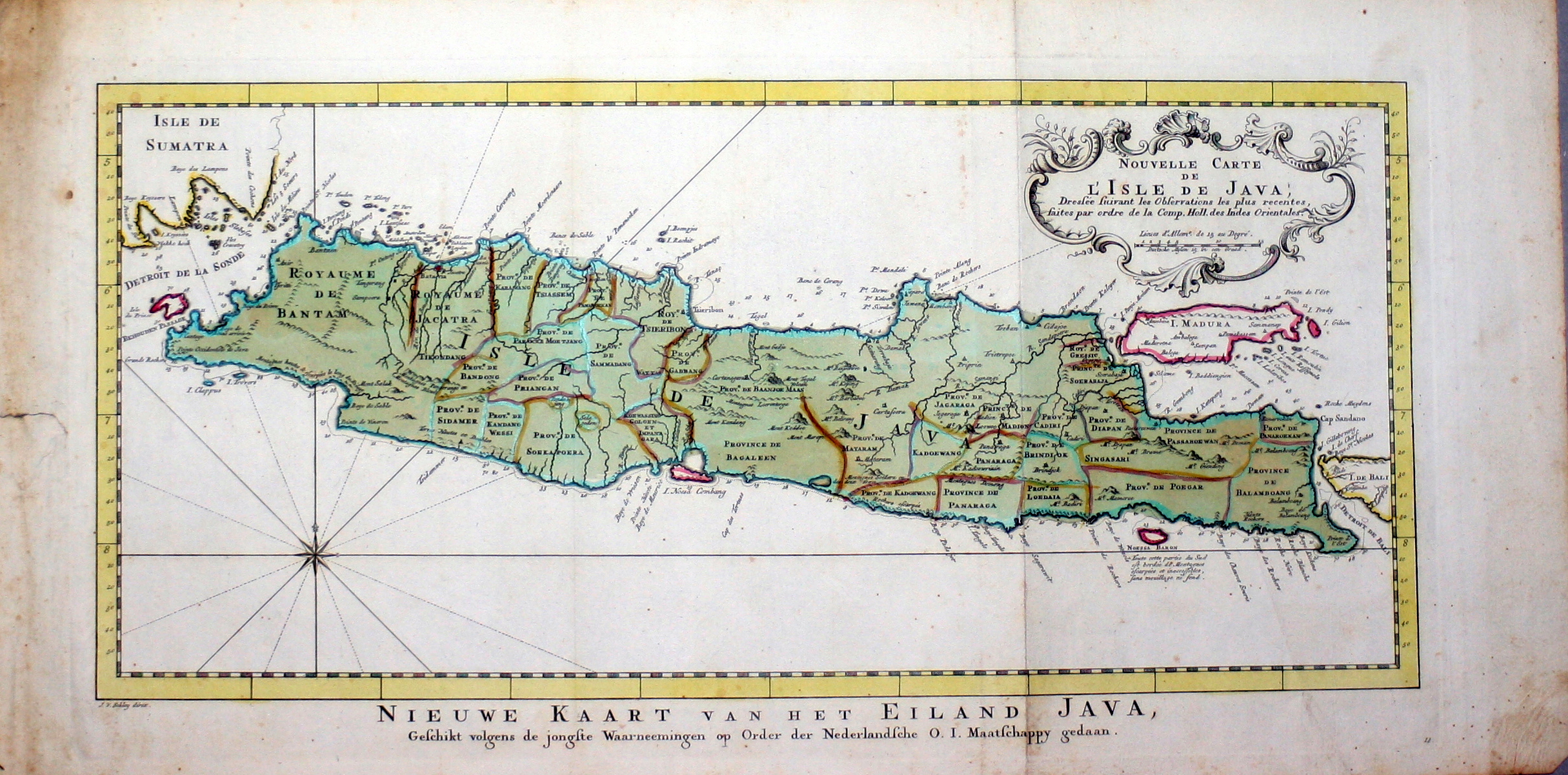
--
Mapmakers
Bordone
LocationLocation shown in map
Java
Edition date
1534
Edition place
Venice
Editor
Federico Torresano
Atlas
Isolario
Price
Please ask: info@thetreasuremaps.com
State
[mint/EXCELLENT/very good/good/fair/mediocre/poor]
Color
Black/white
Verso
Italian text pag.69
Size
Plate: cm (14 x 8.9) inches (5.51 x 3.5) Paper: cm (20.3 x 27.9) inches (7.99 x 10.98)
Technique
Woodcut
Note
No particular notes for this maps.
Reference
--
Wiki
Here for more info
In stock
Sold
Info
info@thetreasuremaps.com
Code
#0667
--
Mapmakers
Bordone
Java
Edition date
1534
Edition place
Venice
Editor
Federico Torresano
Atlas
Isolario
Price
Please ask: info@thetreasuremaps.com
State
[mint/EXCELLENT/very good/good/fair/mediocre/poor]
Color
Black/white
Verso
Italian text pag.69
Size
Plate: cm (14 x 8.9) inches (5.51 x 3.5) Paper: cm (20.3 x 27.9) inches (7.99 x 10.98)
Technique
Woodcut
Note
No particular notes for this maps.
Reference
--
Wiki
Here for more info
In stock
Sold
Info
info@thetreasuremaps.com
Code
#0667
×
![]()

Map title
--
Mapmakers
Bordone
LocationLocation shown in map
Necumera Locaz Patera Botegon Mangama
Edition date
1534
Edition place
Venice
Editor
Federico Torresano
Atlas
Isolario
Price
Please ask: info@thetreasuremaps.com
State
[mint/EXCELLENT/very good/good/fair/mediocre/poor]
Color
Black/white
Verso
Italian text pag.69
Size
Plate: cm (14 x 8) inches (5.51 x 3.15) Paper: cm (20.3 x 29) inches (7.99 x 11.42)
Technique
Woodcut
Note
Locaz or Lochac could be Thailand rendered as an island.
Reference
--
Wiki
Here for more info
In stock
Sold
Info
info@thetreasuremaps.com
Code
#0668
--
Mapmakers
Bordone
Necumera Locaz Patera Botegon Mangama
Edition date
1534
Edition place
Venice
Editor
Federico Torresano
Atlas
Isolario
Price
Please ask: info@thetreasuremaps.com
State
[mint/EXCELLENT/very good/good/fair/mediocre/poor]
Color
Black/white
Verso
Italian text pag.69
Size
Plate: cm (14 x 8) inches (5.51 x 3.15) Paper: cm (20.3 x 29) inches (7.99 x 11.42)
Technique
Woodcut
Note
Locaz or Lochac could be Thailand rendered as an island.
Reference
--
Wiki
Here for more info
In stock
Sold
Info
info@thetreasuremaps.com
Code
#0668
×
![]()
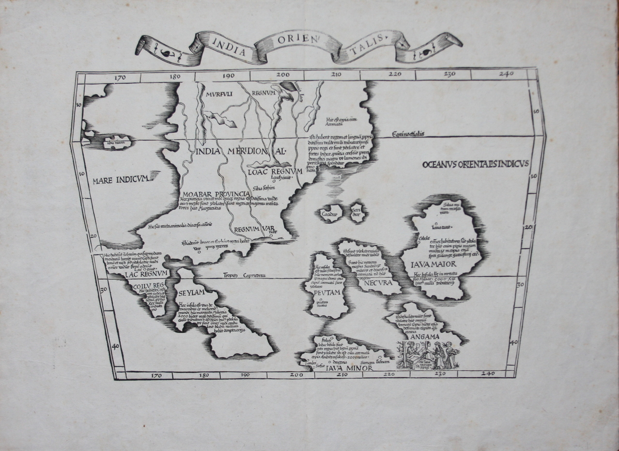
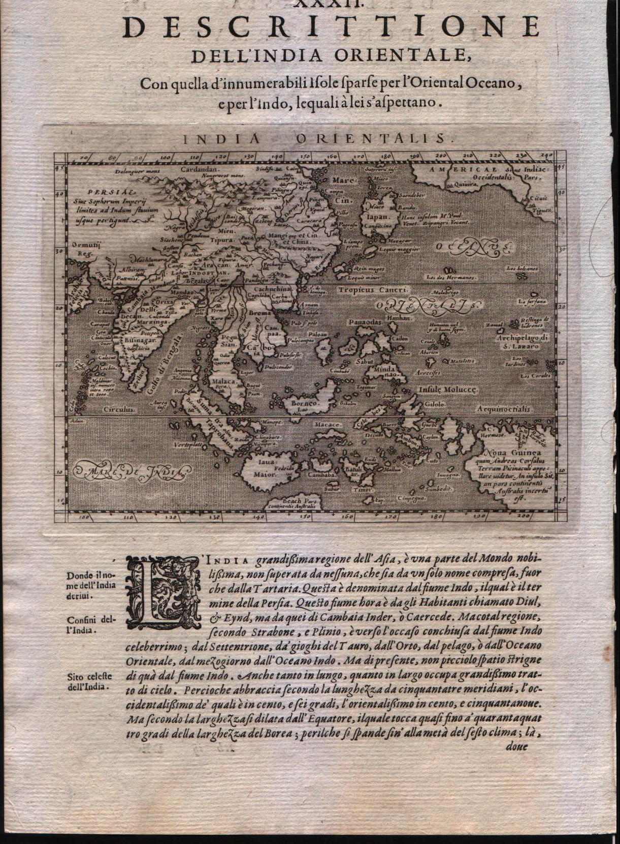
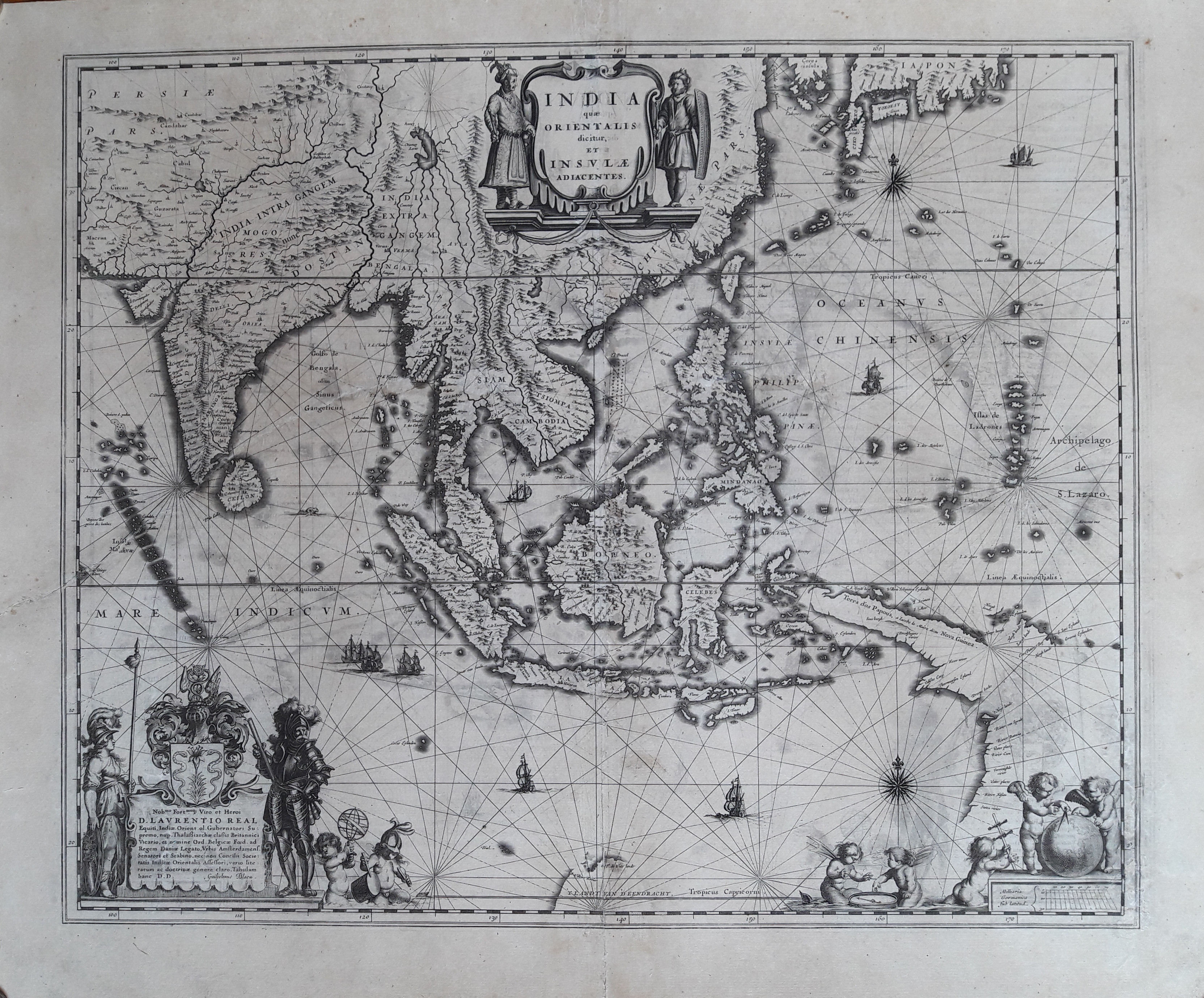
Map title
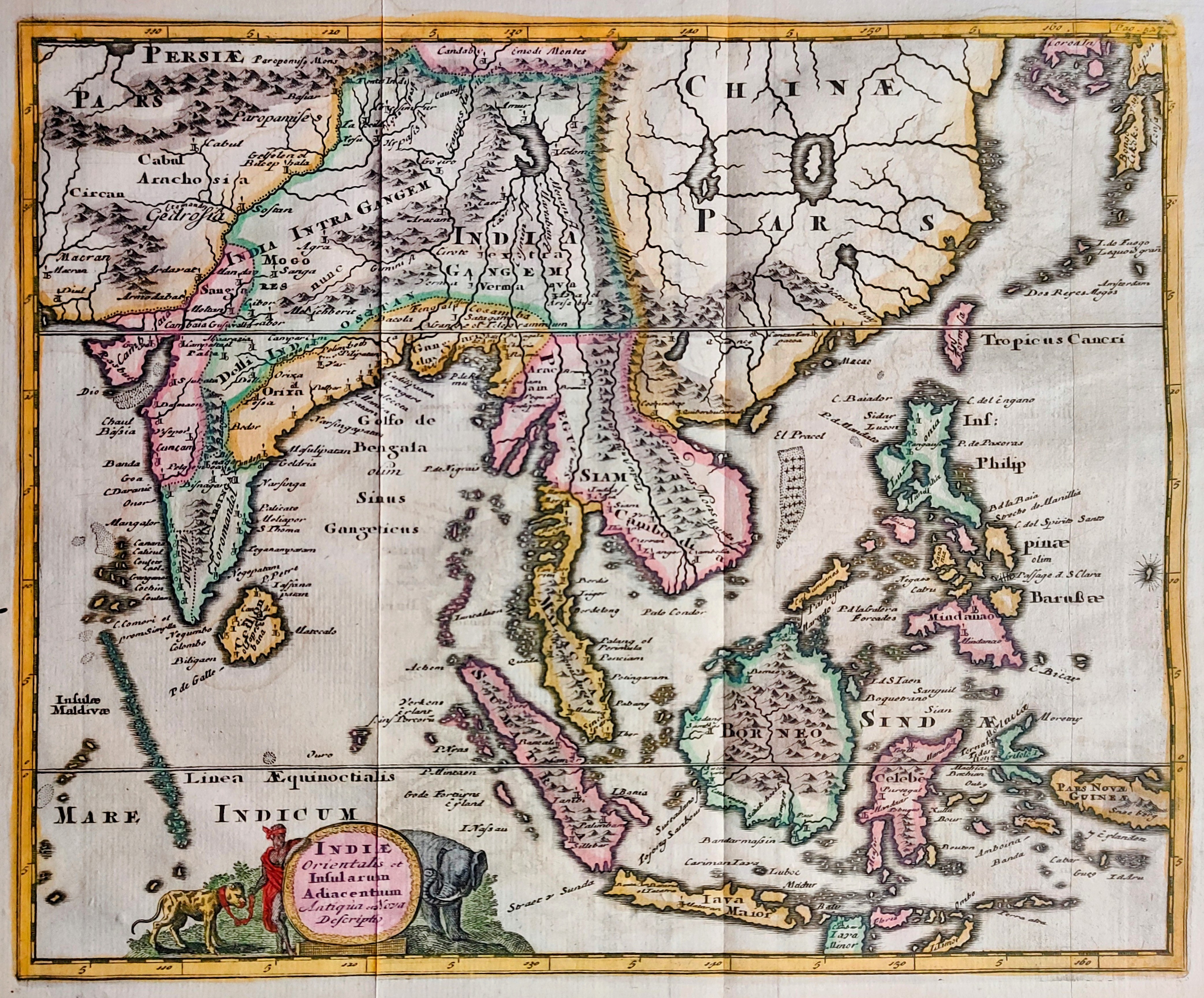
India orientalis
Mapmakers
Fries
LocationLocation shown in map
Southeast Asia
Edition date
1535
Edition place
Lyon
Editor
Melchior and Gaspar Trechsel
Atlas
Ptolemy's Geographia
Price
2000 Euro
State
[mint/EXCELLENT/very good/good/fair/mediocre/poor] repaired
Color
Black/white
Verso
Blank
Size
Plate: cm (41.9 x 30.5) inches (16.5 x 12.01) Paper: cm (55.9 x 40.6) inches (22.01 x 15.98)
Technique
Woodcut
Note
--
Reference
--
Wiki
Here for more info
In stock
Available
Info
info@thetreasuremaps.com
Code
#0173
India orientalis
Mapmakers
Fries
Southeast Asia
Edition date
1535
Edition place
Lyon
Editor
Melchior and Gaspar Trechsel
Atlas
Ptolemy's Geographia
Price
2000 Euro
State
[mint/EXCELLENT/very good/good/fair/mediocre/poor] repaired
Color
Black/white
Verso
Blank
Size
Plate: cm (41.9 x 30.5) inches (16.5 x 12.01) Paper: cm (55.9 x 40.6) inches (22.01 x 15.98)
Technique
Woodcut
Note
--
Reference
--
Wiki
Here for more info
In stock
Available
Info
info@thetreasuremaps.com
Code
#0173
×
![]()
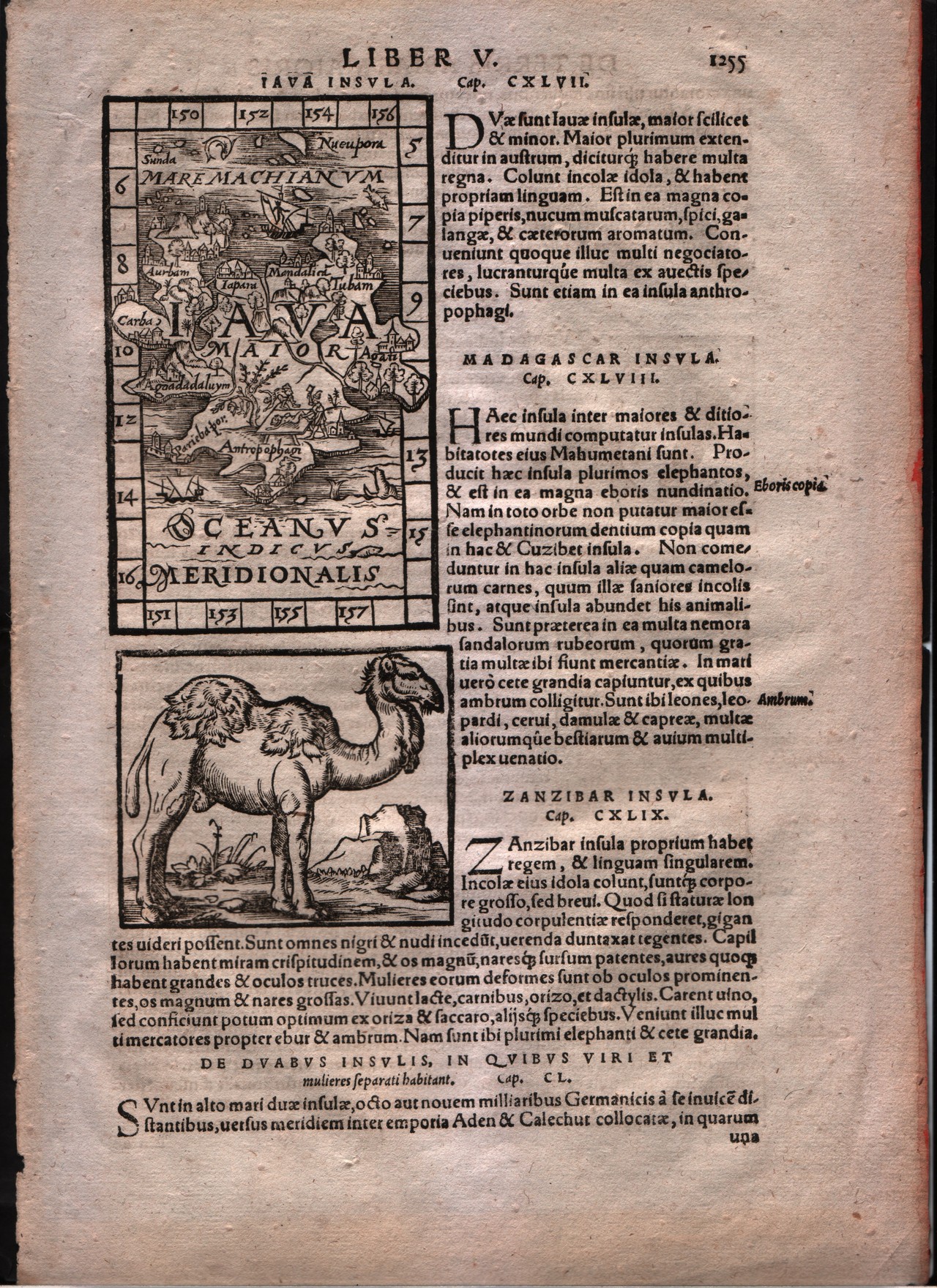
Map title
Iava insula
Mapmakers
Honter
LocationLocation shown in map
Java
Edition date
1561
Edition place
Basle
Editor
--
Atlas
Cosmographiae Rudimentis -- Johannes Honter
Price
Please ask: info@thetreasuremaps.com
State
[mint/EXCELLENT/very good/good/fair/mediocre/poor]
Color
Black/white
Verso
Latin text pag.1255
Size
Plate: cm (7.6 x 12.7) inches (2.99 x 5) Paper: cm (21.6 x 31.8) inches (8.5 x 12.52)
Technique
Woodcut
Note
--
Reference
--
Wiki
Here for more info
In stock
Sold
Info
info@thetreasuremaps.com
Code
#0180
Iava insula
Mapmakers
Honter
Java
Edition date
1561
Edition place
Basle
Editor
--
Atlas
Cosmographiae Rudimentis -- Johannes Honter
Price
Please ask: info@thetreasuremaps.com
State
[mint/EXCELLENT/very good/good/fair/mediocre/poor]
Color
Black/white
Verso
Latin text pag.1255
Size
Plate: cm (7.6 x 12.7) inches (2.99 x 5) Paper: cm (21.6 x 31.8) inches (8.5 x 12.52)
Technique
Woodcut
Note
--
Reference
--
Wiki
Here for more info
In stock
Sold
Info
info@thetreasuremaps.com
Code
#0180
×
![]()
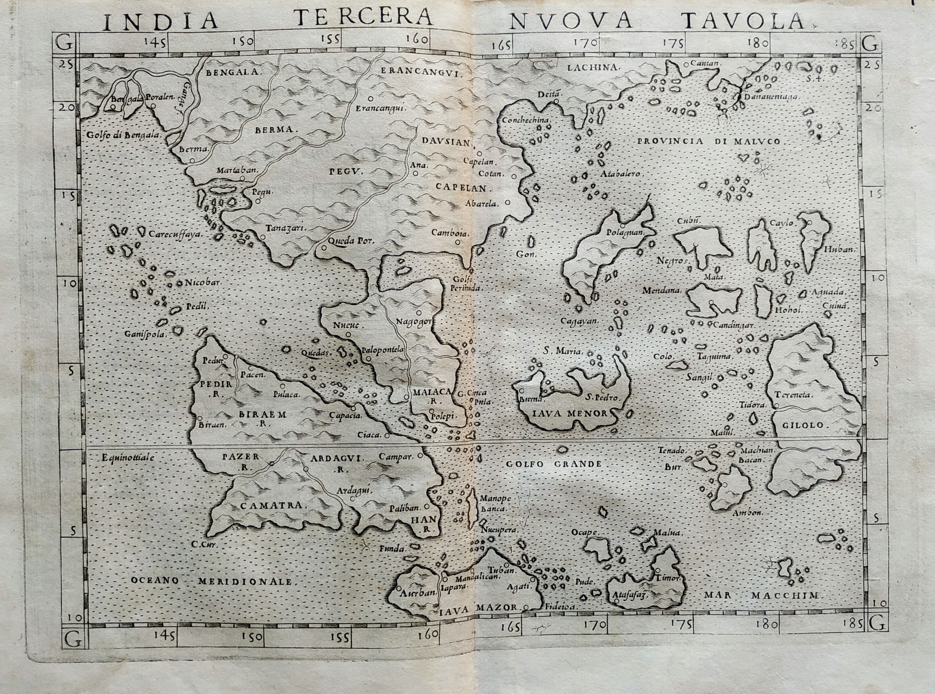
Map title
India tercera nova tabula
Mapmakers
Ruscelli
LocationLocation shown in map
Southeast Asia
Edition date
1561
Edition place
Venice
Editor
Vincenzo Valgrisi
Atlas
La Geographia di Claudio Tolomeo
Price
Please ask: info@thetreasuremaps.com
State
[mint/EXCELLENT/very good/good/fair/mediocre/poor]
Color
Black/white
Verso
Size
Plate: cm (26 x 19) inches (10.24 x 7.48) Paper: cm (27.9 x 20.3) inches (10.98 x 7.99)
Technique
Copper engraving
Note
No particular notes for this maps.
Reference
--
Wiki
Here for more info
In stock
Available
Info
info@thetreasuremaps.com
Code
#0768
India tercera nova tabula
Mapmakers
Ruscelli
Southeast Asia
Edition date
1561
Edition place
Venice
Editor
Vincenzo Valgrisi
Atlas
La Geographia di Claudio Tolomeo
Price
Please ask: info@thetreasuremaps.com
State
[mint/EXCELLENT/very good/good/fair/mediocre/poor]
Color
Black/white
Verso
Size
Plate: cm (26 x 19) inches (10.24 x 7.48) Paper: cm (27.9 x 20.3) inches (10.98 x 7.99)
Technique
Copper engraving
Note
No particular notes for this maps.
Reference
--
Wiki
Here for more info
In stock
Available
Info
info@thetreasuremaps.com
Code
#0768
×
![]()
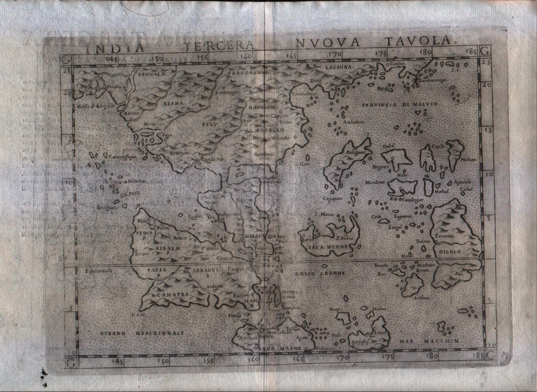
Map title
India tercera nova tabula
Mapmakers
Ruscelli
LocationLocation shown in map
Southeast Asia
Edition date
1574
Edition place
Venice
Editor
Giordano Ziletti
Atlas
La Geographia di Claudio Tolomeo
Price
Please ask: info@thetreasuremaps.com
State
[mint/excellent/VERY GOOD/good/fair/mediocre/poor]
Color
Black/white
Verso
Italian text pag.30
Size
Plate: cm (25.4 x 19) inches (10 x 7.48) Paper: cm (30.5 x 22.9) inches (12.01 x 9.02)
Technique
Copper engraving
Note
India shown.
Reference
Genoa pubblic library "Civica Berio"
Wiki
Here for more info
In stock
Available
Info
info@thetreasuremaps.com
Code
#0182
India tercera nova tabula
Mapmakers
Ruscelli
Southeast Asia
Edition date
1574
Edition place
Venice
Editor
Giordano Ziletti
Atlas
La Geographia di Claudio Tolomeo
Price
Please ask: info@thetreasuremaps.com
State
[mint/excellent/VERY GOOD/good/fair/mediocre/poor]
Color
Black/white
Verso
Italian text pag.30
Size
Plate: cm (25.4 x 19) inches (10 x 7.48) Paper: cm (30.5 x 22.9) inches (12.01 x 9.02)
Technique
Copper engraving
Note
India shown.
Reference
Genoa pubblic library "Civica Berio"
Wiki
Here for more info
In stock
Available
Info
info@thetreasuremaps.com
Code
#0182
×
![]()
Map title
Descrittione dell'isole Molucche
Mapmakers
Porcacchi
LocationLocation shown in map
Southest Asia
Edition date
1576
Edition place
Venice
Editor
--
Atlas
L'Isole piu famose del mondo -- S. Galignani and G. Porro
Price
Please ask: info@thetreasuremaps.com
State
[MINT/excellent/very good/good/fair/mediocre/poor]
Color
Black/white
Verso
Italian text pag.190
Size
Plate: cm (15.2 x 11.4) inches (5.98 x 4.49) Paper: cm (19 x 27.9) inches (7.48 x 10.98)
Technique
Copper engraving
Note
No particular notes for this maps
Reference
Genoa pubblic library "Civica Berio"
Wiki
Here for more info
In stock
Available
Info
info@thetreasuremaps.com
Code
#0196
Descrittione dell'isole Molucche
Mapmakers
Porcacchi
Southest Asia
Edition date
1576
Edition place
Venice
Editor
--
Atlas
L'Isole piu famose del mondo -- S. Galignani and G. Porro
Price
Please ask: info@thetreasuremaps.com
State
[MINT/excellent/very good/good/fair/mediocre/poor]
Color
Black/white
Verso
Italian text pag.190
Size
Plate: cm (15.2 x 11.4) inches (5.98 x 4.49) Paper: cm (19 x 27.9) inches (7.48 x 10.98)
Technique
Copper engraving
Note
No particular notes for this maps
Reference
Genoa pubblic library "Civica Berio"
Wiki
Here for more info
In stock
Available
Info
info@thetreasuremaps.com
Code
#0196
×
![]()
Map title
Descrittione dell'isole Molucche
Mapmakers
Porcacchi
LocationLocation shown in map
Southest Asia
Edition date
1576
Edition place
Venice
Editor
--
Atlas
L'Isole piu famose del mondo -- S. Galignani and G. Porro
Price
400 Euro
State
[MINT/excellent/very good/good/fair/mediocre/poor]
Color
Black/white
Verso
Italian text pag.190
Size
Plate: cm (15.2 x 11.4) inches (5.98 x 4.49) Paper: cm (19 x 27.9) inches (7.48 x 10.98)
Technique
Copper engraving
Note
Reference
Genoa pubblic library "Civica Berio"
Wiki
Here for more info
In stock
Available
Info
info@thetreasuremaps.com
Code
#1077
Descrittione dell'isole Molucche
Mapmakers
Porcacchi
Southest Asia
Edition date
1576
Edition place
Venice
Editor
--
Atlas
L'Isole piu famose del mondo -- S. Galignani and G. Porro
Price
400 Euro
State
[MINT/excellent/very good/good/fair/mediocre/poor]
Color
Black/white
Verso
Italian text pag.190
Size
Plate: cm (15.2 x 11.4) inches (5.98 x 4.49) Paper: cm (19 x 27.9) inches (7.48 x 10.98)
Technique
Copper engraving
Note
Reference
Genoa pubblic library "Civica Berio"
Wiki
Here for more info
In stock
Available
Info
info@thetreasuremaps.com
Code
#1077
×
![]()
Map title
Indiae orientalis
Mapmakers
Ortelius
LocationLocation shown in map
Southeast Asia
Edition date
1598
Edition place
Brescia
Editor
Pietro Marchetti
Atlas
Theatro del mondo
Price
150 Euro
State
[mint/EXCELLENT/very good/good/fair/mediocre/poor]
Color
Black/white
Verso
Italian text
Size
Plate: cm (11 x 8) inches (4.33 x 3.15) Paper: cm (11 x 8) inches (4.33 x 3.15)
Technique
Copper engraving
Note
Reference
Wiki
Here for more info
In stock
Available
Info
info@thetreasuremaps.com
Code
#0861
Indiae orientalis
Mapmakers
Ortelius
Southeast Asia
Edition date
1598
Edition place
Brescia
Editor
Pietro Marchetti
Atlas
Theatro del mondo
Price
150 Euro
State
[mint/EXCELLENT/very good/good/fair/mediocre/poor]
Color
Black/white
Verso
Italian text
Size
Plate: cm (11 x 8) inches (4.33 x 3.15) Paper: cm (11 x 8) inches (4.33 x 3.15)
Technique
Copper engraving
Note
Reference
Wiki
Here for more info
In stock
Available
Info
info@thetreasuremaps.com
Code
#0861
×
![]()
Map title
Indiae orientalis insularumque adiacientium typus
Mapmakers
Ortelius
LocationLocation shown in map
Southeast Asia
Edition date
1598
Edition place
Brescia
Editor
--
Atlas
Theatro del mondo -- Compania Bresciana
Price
200 Euro
State
[mint/EXCELLENT/very good/good/fair/mediocre/poor]
Color
Black/white
Verso
Italian text pag.199
Size
Plate: cm (11 x 8) inches (4.33 x 3.15) Paper: cm (14 x 19) inches (5.51 x 7.48)
Technique
Copper engraving
Note
No particular notes for this maps.
Reference
--
Wiki
Here for more info
In stock
Available
Info
info@thetreasuremaps.com
Code
#0199
Indiae orientalis insularumque adiacientium typus
Mapmakers
Ortelius
Southeast Asia
Edition date
1598
Edition place
Brescia
Editor
--
Atlas
Theatro del mondo -- Compania Bresciana
Price
200 Euro
State
[mint/EXCELLENT/very good/good/fair/mediocre/poor]
Color
Black/white
Verso
Italian text pag.199
Size
Plate: cm (11 x 8) inches (4.33 x 3.15) Paper: cm (14 x 19) inches (5.51 x 7.48)
Technique
Copper engraving
Note
No particular notes for this maps.
Reference
--
Wiki
Here for more info
In stock
Available
Info
info@thetreasuremaps.com
Code
#0199
×
![]()
Map title
India orientalis
Mapmakers
Magini
LocationLocation shown in map
Southest Asia
Edition date
1598
Edition place
Venice
Editor
Battista & Giorgio Galignani
Atlas
Geografia di Claudio Tolomeo -- Giovanni Antonio Magini
Price
Please ask: info@thetreasuremaps.com
State
[MINT/excellent/very good/good/fair/mediocre/poor]
Color
Black/white
Verso
Italian text pag.183
Size
Plate: cm (12.7 x 17.8) inches (5 x 7.01) Paper: cm (20.3 x 30.5) inches (7.99 x 12.01)
Technique
Copper engraving
Note
The Far East.
Reference
--
Wiki
Here for more info
In stock
Available
Info
info@thetreasuremaps.com
Code
#0211
India orientalis
Mapmakers
Magini
Southest Asia
Edition date
1598
Edition place
Venice
Editor
Battista & Giorgio Galignani
Atlas
Geografia di Claudio Tolomeo -- Giovanni Antonio Magini
Price
Please ask: info@thetreasuremaps.com
State
[MINT/excellent/very good/good/fair/mediocre/poor]
Color
Black/white
Verso
Italian text pag.183
Size
Plate: cm (12.7 x 17.8) inches (5 x 7.01) Paper: cm (20.3 x 30.5) inches (7.99 x 12.01)
Technique
Copper engraving
Note
The Far East.
Reference
--
Wiki
Here for more info
In stock
Available
Info
info@thetreasuremaps.com
Code
#0211
×
![]()
Map title
Sumatra
Mapmakers
Munster
LocationLocation shown in map
Sumatra
Edition date
1598
Edition place
Basel
Editor
Henrich Petri
Atlas
Cosmographia Universalis
Price
400 Euro
State
[mint/excellent/VERY GOOD/good/fair/mediocre/poor]
Color
Black/white
Verso
German text
Size
Plate: cm (57 x 47) inches (22.44 x 18.5) Paper: cm (66 x 55) inches (25.98 x 21.65)
Technique
Woodcut
Note
No particular notes for this maps
Reference
--
Wiki
Here for more info
In stock
Available
Info
info@thetreasuremaps.com
Code
#0733
Sumatra
Mapmakers
Munster
Sumatra
Edition date
1598
Edition place
Basel
Editor
Henrich Petri
Atlas
Cosmographia Universalis
Price
400 Euro
State
[mint/excellent/VERY GOOD/good/fair/mediocre/poor]
Color
Black/white
Verso
German text
Size
Plate: cm (57 x 47) inches (22.44 x 18.5) Paper: cm (66 x 55) inches (25.98 x 21.65)
Technique
Woodcut
Note
No particular notes for this maps
Reference
--
Wiki
Here for more info
In stock
Available
Info
info@thetreasuremaps.com
Code
#0733
×
![]()
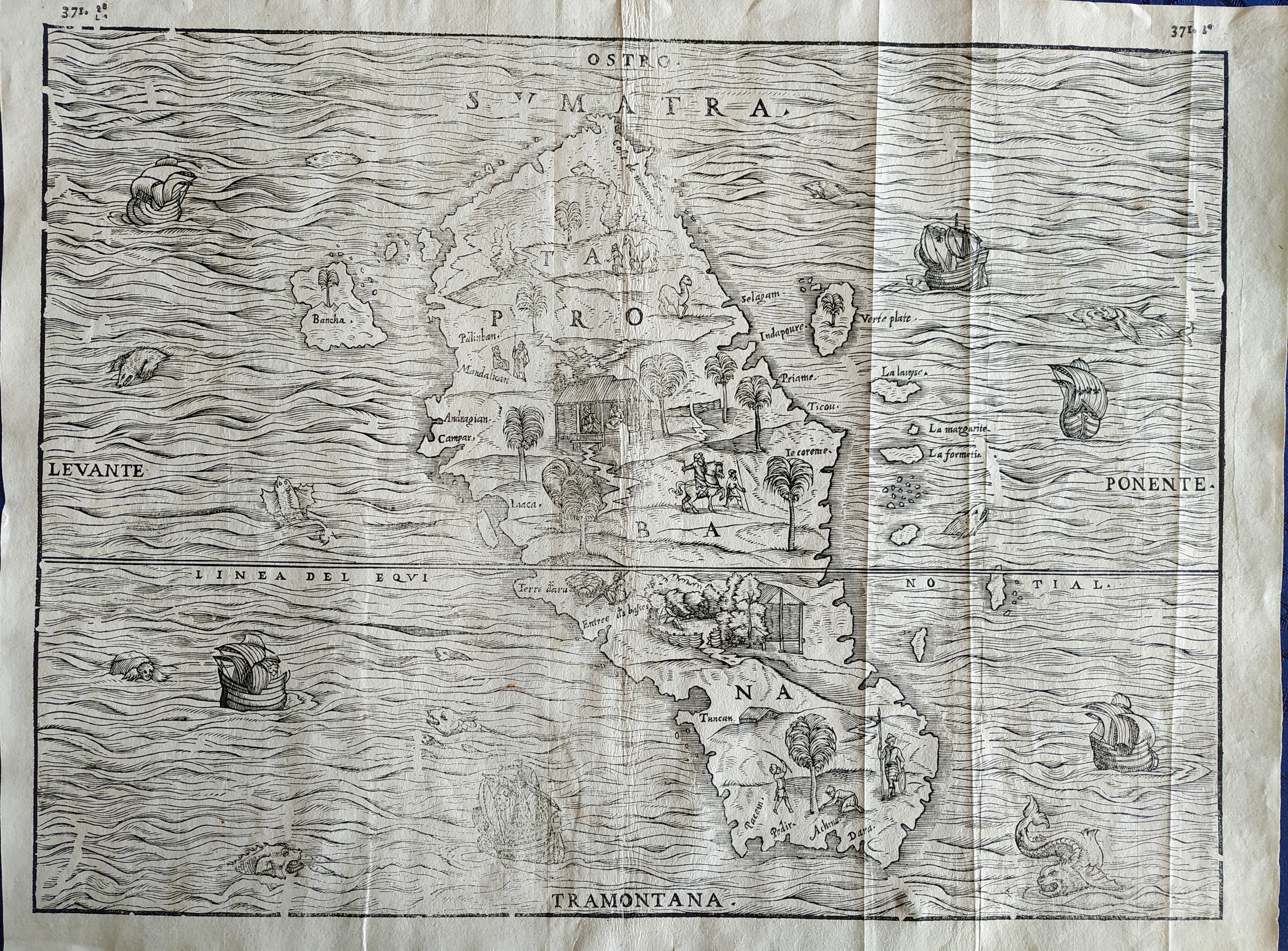
Map title
Sumatra
Mapmakers
Gastaldi
LocationLocation shown in map
Sumatra
Edition date
1606
Edition place
Venice
Editor
Giambattista Ramusio
Atlas
Delle navigazioni e viaggi
Price
Please ask: info@thetreasuremaps.com
State
[mint/excellent/VERY GOOD/good/fair/mediocre/poor]
Color
Black/white
Verso
pag.371
Size
Plate: cm (36 x 27) inches (14.17 x 10.63) Paper: cm (39 x 29) inches (15.35 x 11.42)
Technique
Woodcut
Note
Decorated with sea monsters and sailing ships.
Reference
--
Wiki
Here for more info
In stock
Available
Info
info@thetreasuremaps.com
Code
#0751
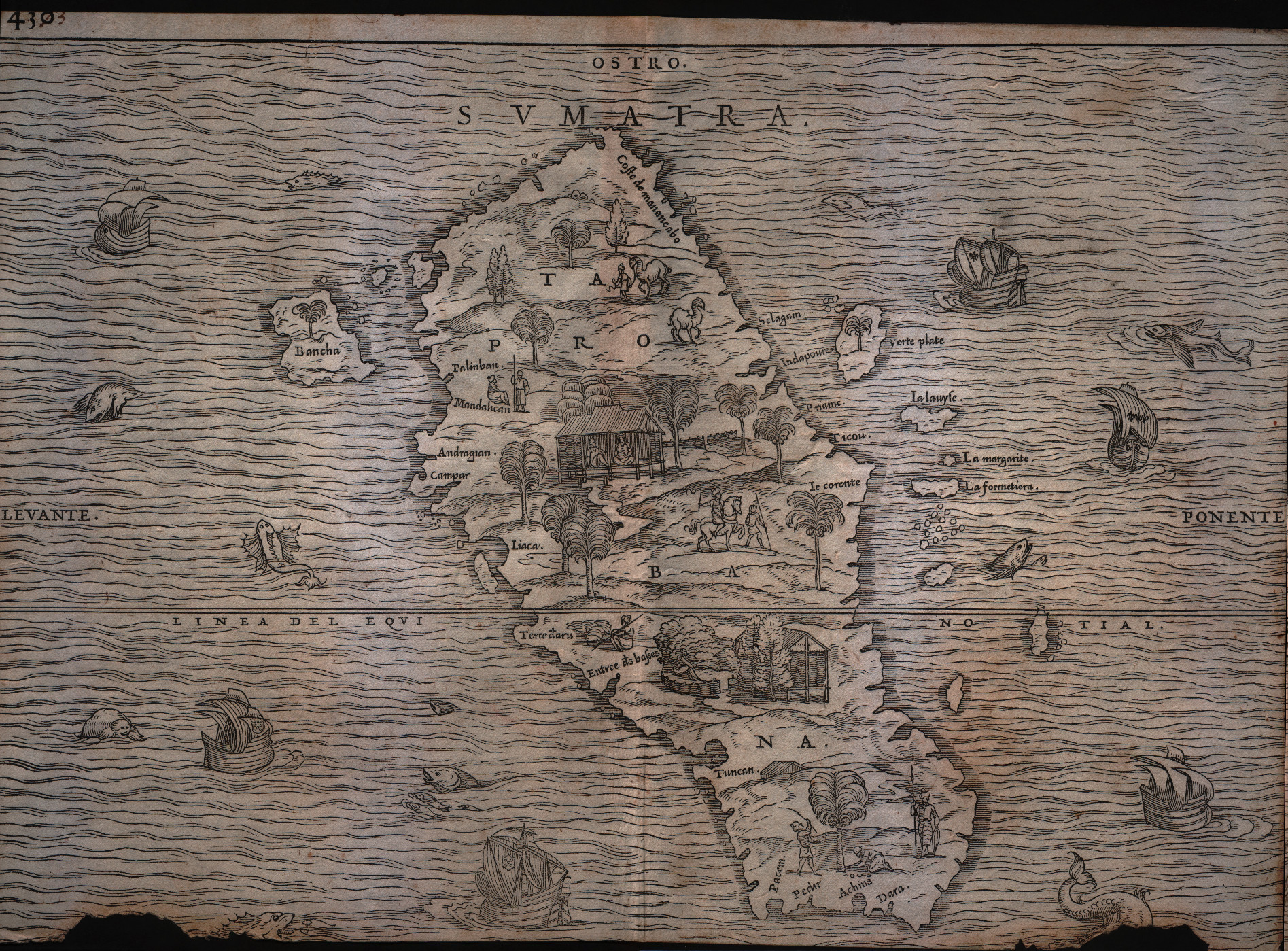
Sumatra
Mapmakers
Gastaldi
Sumatra
Edition date
1606
Edition place
Venice
Editor
Giambattista Ramusio
Atlas
Delle navigazioni e viaggi
Price
Please ask: info@thetreasuremaps.com
State
[mint/excellent/VERY GOOD/good/fair/mediocre/poor]
Color
Black/white
Verso
pag.371
Size
Plate: cm (36 x 27) inches (14.17 x 10.63) Paper: cm (39 x 29) inches (15.35 x 11.42)
Technique
Woodcut
Note
Decorated with sea monsters and sailing ships.
Reference
--
Wiki
Here for more info
In stock
Available
Info
info@thetreasuremaps.com
Code
#0751
×
![]()
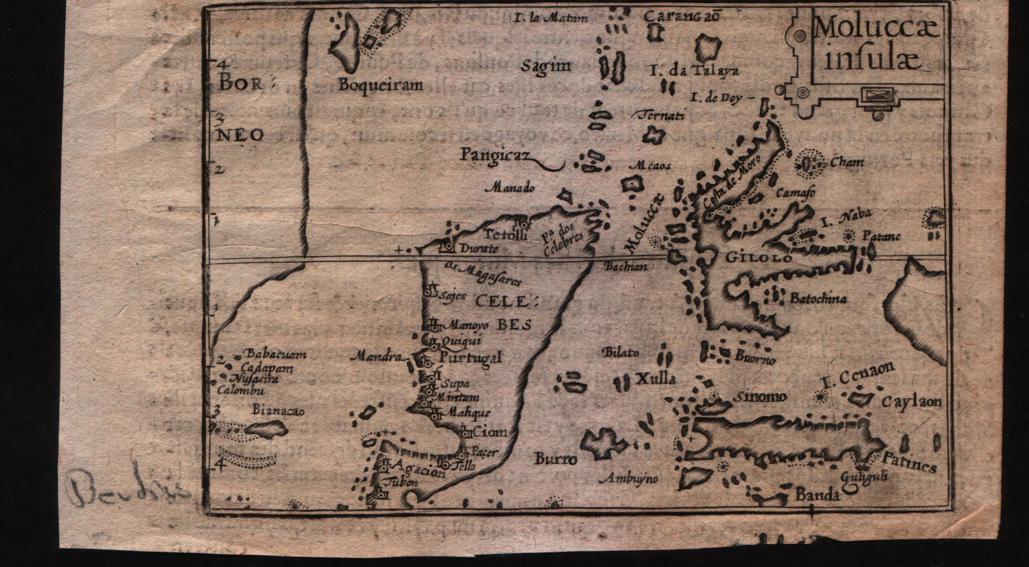
Map title
Moluccae insulae
Mapmakers
Bertius
LocationLocation shown in map
Moluccas
Edition date
Circa 1612
Edition place
Amsterdam
Editor
Jodocus Hondius
Atlas
Tabularum geographicarum contractarum
Price
Please ask: info@thetreasuremaps.com
State
[MINT/excellent/very good/good/fair/mediocre/poor]
Color
Black/white
Verso
French text pag 58
Size
Plate: cm (12.7 x 8.9) inches (5 x 3.5) Paper: cm (16.5 x 10.2) inches (6.5 x 4.02)
Technique
Copper engraving
Note
--
Reference
--
Wiki
Here for more info
In stock
Available
Info
info@thetreasuremaps.com
Code
#0596
Moluccae insulae
Mapmakers
Bertius
Moluccas
Edition date
Circa 1612
Edition place
Amsterdam
Editor
Jodocus Hondius
Atlas
Tabularum geographicarum contractarum
Price
Please ask: info@thetreasuremaps.com
State
[MINT/excellent/very good/good/fair/mediocre/poor]
Color
Black/white
Verso
French text pag 58
Size
Plate: cm (12.7 x 8.9) inches (5 x 3.5) Paper: cm (16.5 x 10.2) inches (6.5 x 4.02)
Technique
Copper engraving
Note
--
Reference
--
Wiki
Here for more info
In stock
Available
Info
info@thetreasuremaps.com
Code
#0596
×
![]()
Map title
Sumatra
Mapmakers
Gastaldi
LocationLocation shown in map
Sumatra
Edition date
1613
Edition place
Venice
Editor
Giambattista Ramusio
Atlas
Delle navigazioni e viaggi
Price
Please ask: info@thetreasuremaps.com
State
[mint/excellent/very good/good/FAIR/mediocre/poor]
Color
Black/white
Verso
pag.430
Size
Plate: cm (36.8 x 26.7) inches (14.49 x 10.51) Paper: cm (36.8 x 26.7) inches (14.49 x 10.51)
Technique
Woodcut
Note
Decorated with sea monsters and sailing ships.
Reference
--
Wiki
Here for more info
In stock
Available
Info
info@thetreasuremaps.com
Code
#0179
Sumatra
Mapmakers
Gastaldi
Sumatra
Edition date
1613
Edition place
Venice
Editor
Giambattista Ramusio
Atlas
Delle navigazioni e viaggi
Price
Please ask: info@thetreasuremaps.com
State
[mint/excellent/very good/good/FAIR/mediocre/poor]
Color
Black/white
Verso
pag.430
Size
Plate: cm (36.8 x 26.7) inches (14.49 x 10.51) Paper: cm (36.8 x 26.7) inches (14.49 x 10.51)
Technique
Woodcut
Note
Decorated with sea monsters and sailing ships.
Reference
--
Wiki
Here for more info
In stock
Available
Info
info@thetreasuremaps.com
Code
#0179
×
![]()
Map title
Description de Java
Mapmakers
Bertius
LocationLocation shown in map
Java Maior
Edition date
1617
Edition place
Amsterdam
Editor
Jodocus Hondius
Atlas
Tabularum geographicarum contractarum
Price
Please ask: info@thetreasuremaps.com
State
[MINT/excellent/very good/good/fair/mediocre/poor]
Color
Black/white
Verso
French text pag 747
Size
Plate: cm (14 x 10.2) inches (5.51 x 4.02) Paper: cm (17.8 x 11.4) inches (7.01 x 4.49)
Technique
Copper engraving
Note
--
Reference
--
Wiki
Here for more info
In stock
Sold
Info
info@thetreasuremaps.com
Code
#0591
Description de Java
Mapmakers
Bertius
Java Maior
Edition date
1617
Edition place
Amsterdam
Editor
Jodocus Hondius
Atlas
Tabularum geographicarum contractarum
Price
Please ask: info@thetreasuremaps.com
State
[MINT/excellent/very good/good/fair/mediocre/poor]
Color
Black/white
Verso
French text pag 747
Size
Plate: cm (14 x 10.2) inches (5.51 x 4.02) Paper: cm (17.8 x 11.4) inches (7.01 x 4.49)
Technique
Copper engraving
Note
--
Reference
--
Wiki
Here for more info
In stock
Sold
Info
info@thetreasuremaps.com
Code
#0591
×
![]()
Map title
India que orientalis dicitur et insulae adiacentis
Mapmakers
Blaeu
LocationLocation shown in map
Southest Asia
Edition date
1635
Edition place
Amsterdam
Editor
--
Atlas
Theatrum Orbis Terrarum, Sive Atlas Novis
Price
Please ask: info@thetreasuremaps.com
State
[mint/excellent/very good/GOOD/fair/mediocre/poor]
Color
Black/white
Verso
Latin text pag.2
Size
Plate: cm (50.8 x 40.6) inches (20 x 15.98) Paper: cm (58.4 x 45.7) inches (22.99 x 17.99)
Technique
Copper engraving
Note
The Far East.
Reference
--
Wiki
Here for more info
In stock
Available
Info
info@thetreasuremaps.com
Code
#0212
India que orientalis dicitur et insulae adiacentis
Mapmakers
Blaeu
Southest Asia
Edition date
1635
Edition place
Amsterdam
Editor
--
Atlas
Theatrum Orbis Terrarum, Sive Atlas Novis
Price
Please ask: info@thetreasuremaps.com
State
[mint/excellent/very good/GOOD/fair/mediocre/poor]
Color
Black/white
Verso
Latin text pag.2
Size
Plate: cm (50.8 x 40.6) inches (20 x 15.98) Paper: cm (58.4 x 45.7) inches (22.99 x 17.99)
Technique
Copper engraving
Note
The Far East.
Reference
--
Wiki
Here for more info
In stock
Available
Info
info@thetreasuremaps.com
Code
#0212
×
![]()
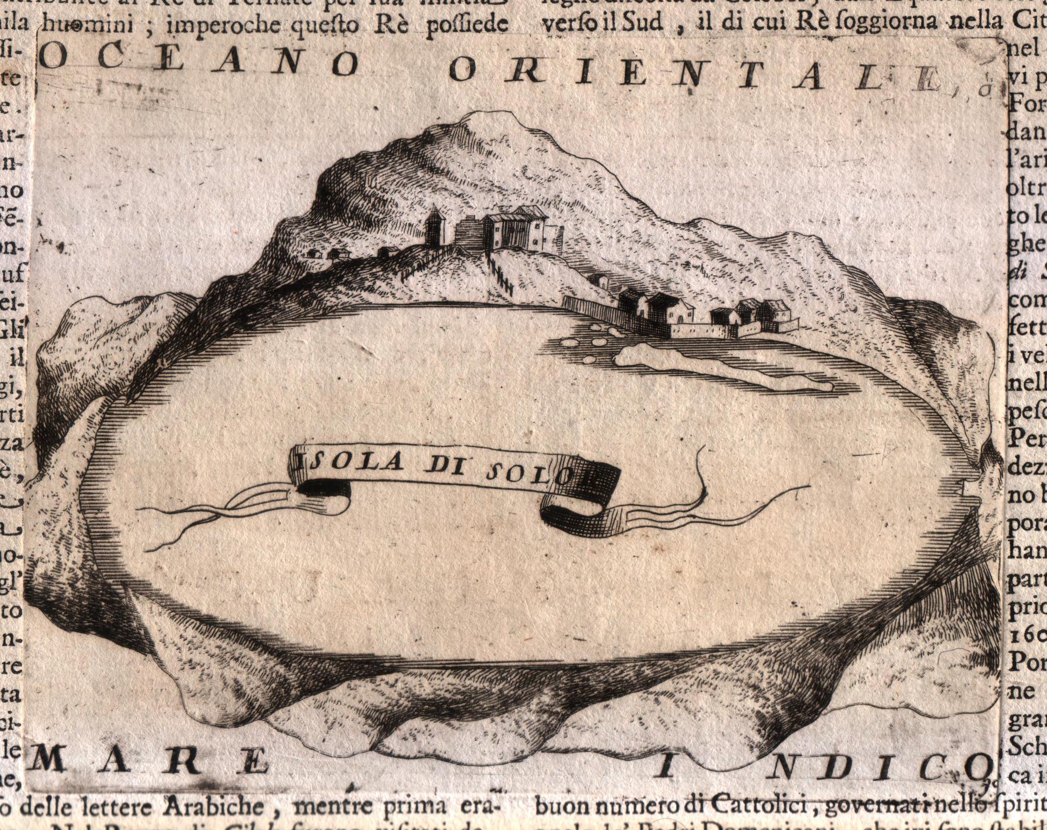
Map title
Isola di Solo
Mapmakers
Coronelli
LocationLocation shown in map
Sula island
Edition date
Circa 1696
Edition place
Venice
Editor
Coronelli
Atlas
Atlante veneto
Price
Please ask: info@thetreasuremaps.com
State
[MINT/excellent/very good/good/fair/mediocre/poor]
Color
Black/white
Verso
Italian text
Size
Plate: cm (17.8 x 14) inches (7.01 x 5.51) Paper: cm (50.8 x 35.6) inches (20 x 14.02)
Technique
Copper engraving
Note
No particular notes for this maps.
Reference
--
Wiki
Here for more info
In stock
Available
Info
info@thetreasuremaps.com
Code
#0572
Isola di Solo
Mapmakers
Coronelli
Sula island
Edition date
Circa 1696
Edition place
Venice
Editor
Coronelli
Atlas
Atlante veneto
Price
Please ask: info@thetreasuremaps.com
State
[MINT/excellent/very good/good/fair/mediocre/poor]
Color
Black/white
Verso
Italian text
Size
Plate: cm (17.8 x 14) inches (7.01 x 5.51) Paper: cm (50.8 x 35.6) inches (20 x 14.02)
Technique
Copper engraving
Note
No particular notes for this maps.
Reference
--
Wiki
Here for more info
In stock
Available
Info
info@thetreasuremaps.com
Code
#0572
×
![]()
Map title
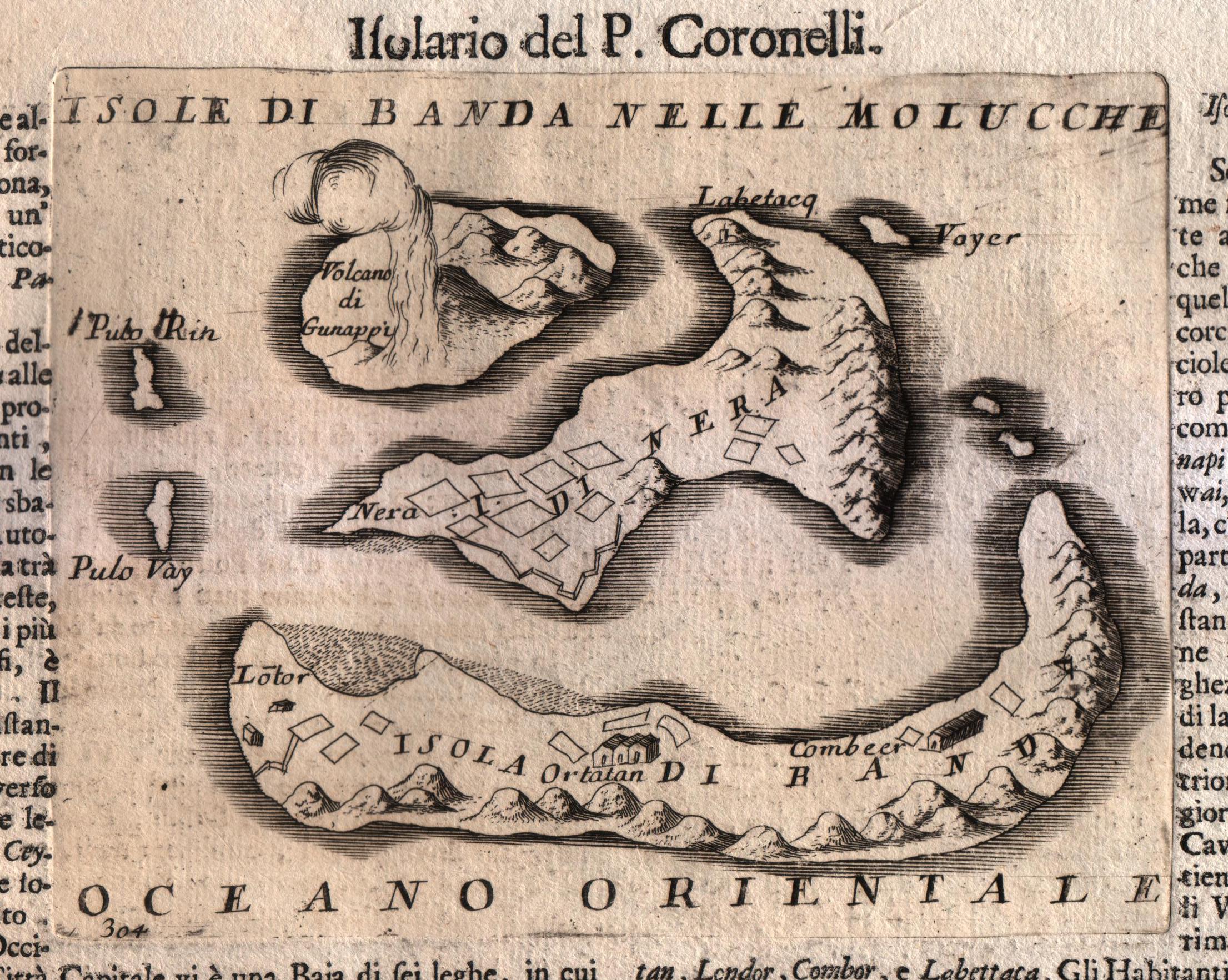
Isole di Banda nelle Molucche
Mapmakers
Coronelli
LocationLocation shown in map
Banda island
Edition date
Circa 1696
Edition place
Venice
Editor
Coronelli
Atlas
Atlante veneto
Price
250 Euro
State
[MINT/excellent/very good/good/fair/mediocre/poor]
Color
Black/white
Verso
Italian text
Size
Plate: cm (17.8 x 14) inches (7.01 x 5.51) Paper: cm (50.8 x 35.6) inches (20 x 14.02)
Technique
Copper engraving
Note
No particular notes for this maps.
Reference
--
Wiki
Here for more info
In stock
Available
Info
info@thetreasuremaps.com
Code
#0571
Isole di Banda nelle Molucche
Mapmakers
Coronelli
Banda island
Edition date
Circa 1696
Edition place
Venice
Editor
Coronelli
Atlas
Atlante veneto
Price
250 Euro
State
[MINT/excellent/very good/good/fair/mediocre/poor]
Color
Black/white
Verso
Italian text
Size
Plate: cm (17.8 x 14) inches (7.01 x 5.51) Paper: cm (50.8 x 35.6) inches (20 x 14.02)
Technique
Copper engraving
Note
No particular notes for this maps.
Reference
--
Wiki
Here for more info
In stock
Available
Info
info@thetreasuremaps.com
Code
#0571
×
![]()
Map title
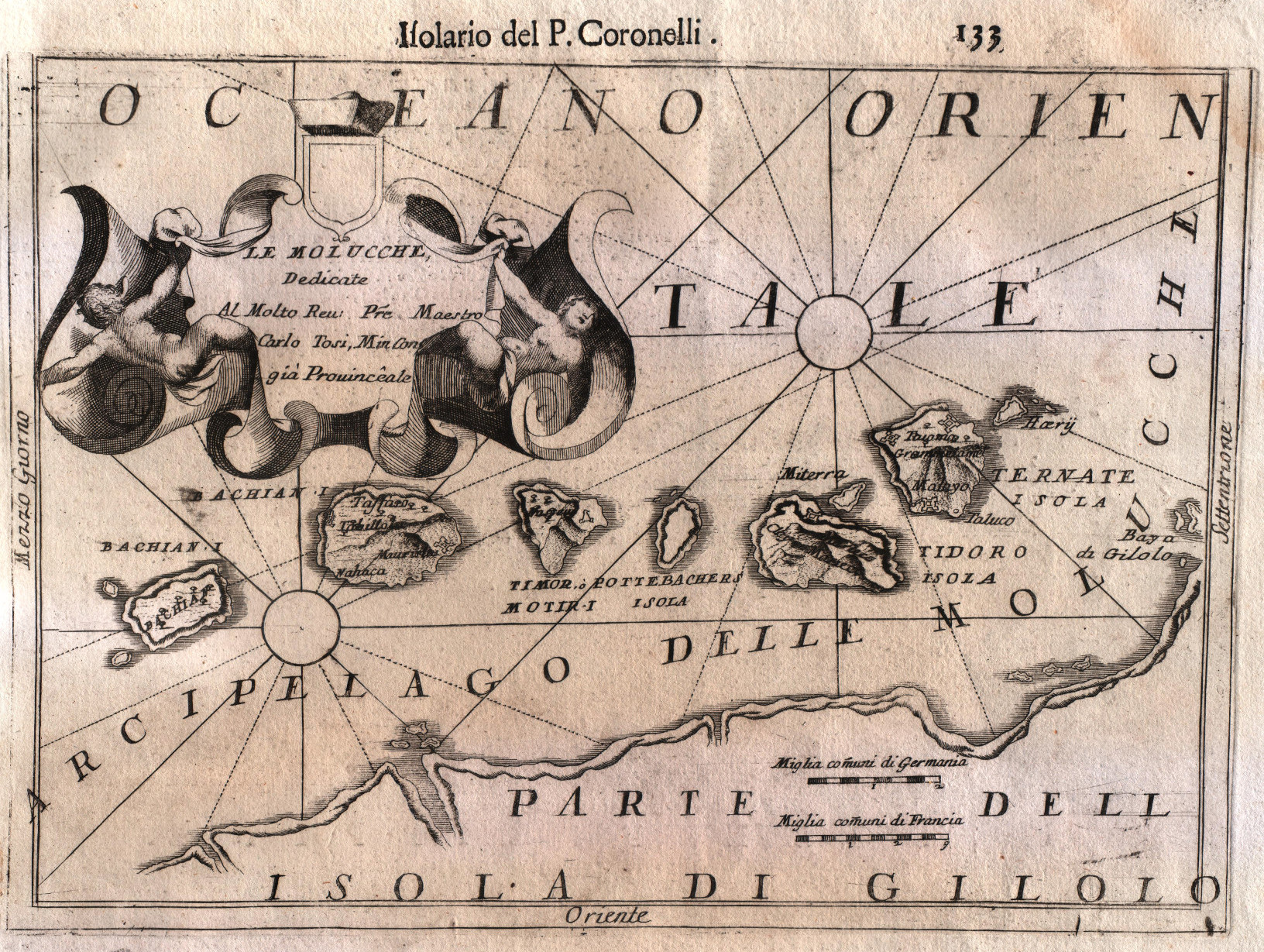
Arcipelago delle Molucche
Mapmakers
Coronelli
LocationLocation shown in map
Moluccas
Edition date
Circa 1696
Edition place
Venice
Editor
Coronelli
Atlas
Atlante veneto
Price
250 Euro
State
[MINT/excellent/very good/good/fair/mediocre/poor]
Color
Black/white
Verso
Italian text
Size
Plate: cm (30.5 x 22.9) inches (12.01 x 9.02) Paper: cm (50.8 x 35.6) inches (20 x 14.02)
Technique
Copper engraving
Note
No particular notes for this maps.
Reference
--
Wiki
Here for more info
In stock
Available
Info
info@thetreasuremaps.com
Code
#0573
Arcipelago delle Molucche
Mapmakers
Coronelli
Moluccas
Edition date
Circa 1696
Edition place
Venice
Editor
Coronelli
Atlas
Atlante veneto
Price
250 Euro
State
[MINT/excellent/very good/good/fair/mediocre/poor]
Color
Black/white
Verso
Italian text
Size
Plate: cm (30.5 x 22.9) inches (12.01 x 9.02) Paper: cm (50.8 x 35.6) inches (20 x 14.02)
Technique
Copper engraving
Note
No particular notes for this maps.
Reference
--
Wiki
Here for more info
In stock
Available
Info
info@thetreasuremaps.com
Code
#0573
×
![]()
Map title
Indiae orientalis
Mapmakers
Cluver
LocationLocation shown in map
Southeast Asia
Edition date
1697
Edition place
Leiden
Editor
Atlas
Introductionis in Universam Geographiam ...
Price
200 Euro
State
[mint/EXCELLENT/very good/good/fair/mediocre/poor]
Color
Old colors
Verso
Blank
Size
Plate: cm (33 x 25) inches (12.99 x 9.84) Paper: cm (27 x 22) inches (10.63 x 8.66)
Technique
Copper engraving
Note
Reference
Wiki
Here for more info
In stock
Available
Info
info@thetreasuremaps.com
Code
#0865
Indiae orientalis
Mapmakers
Cluver
Southeast Asia
Edition date
1697
Edition place
Leiden
Editor
Atlas
Introductionis in Universam Geographiam ...
Price
200 Euro
State
[mint/EXCELLENT/very good/good/fair/mediocre/poor]
Color
Old colors
Verso
Blank
Size
Plate: cm (33 x 25) inches (12.99 x 9.84) Paper: cm (27 x 22) inches (10.63 x 8.66)
Technique
Copper engraving
Note
Reference
Wiki
Here for more info
In stock
Available
Info
info@thetreasuremaps.com
Code
#0865
×
![]()
Map title
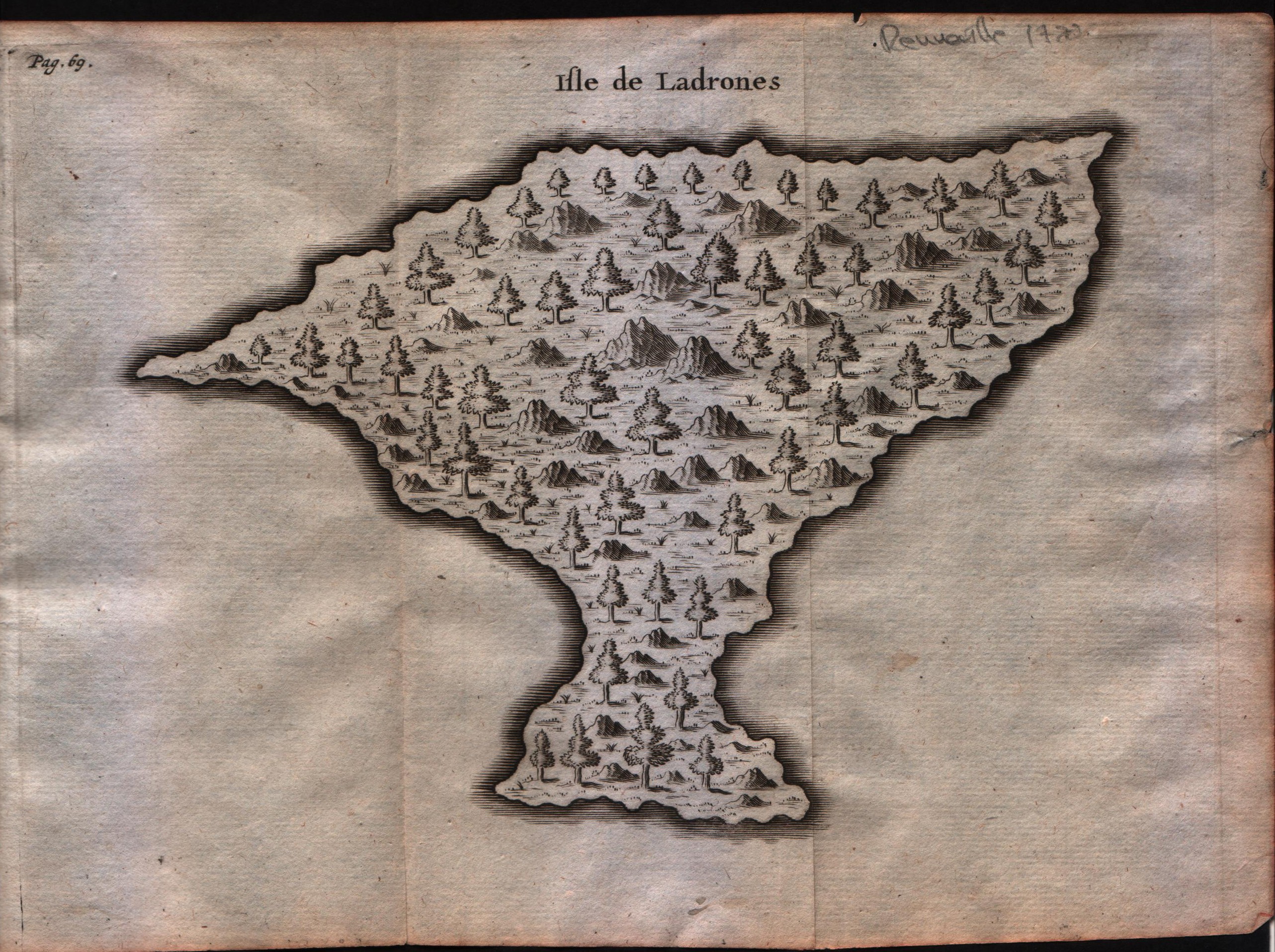
Isle de Ladrones
Mapmakers
Unknown
LocationLocation shown in map
Marianne island
Edition date
Circa 1722
Edition place
Amsterdam
Editor
F.Bernard
Atlas
Recueil des voyages qui ont servi a ...
Price
150 Euro
State
[MINT/excellent/very good/good/fair/mediocre/poor]
Color
Black/white
Verso
Blank
Size
Plate: cm (20.3 x 15.2) inches (7.99 x 5.98) Paper: cm (22.9 x 15.2) inches (9.02 x 5.98)
Technique
Copper engraving
Note
--
Reference
--
Wiki
Here for more info
In stock
Available
Info
info@thetreasuremaps.com
Code
#0593
Isle de Ladrones
Mapmakers
Unknown
Marianne island
Edition date
Circa 1722
Edition place
Amsterdam
Editor
F.Bernard
Atlas
Recueil des voyages qui ont servi a ...
Price
150 Euro
State
[MINT/excellent/very good/good/fair/mediocre/poor]
Color
Black/white
Verso
Blank
Size
Plate: cm (20.3 x 15.2) inches (7.99 x 5.98) Paper: cm (22.9 x 15.2) inches (9.02 x 5.98)
Technique
Copper engraving
Note
--
Reference
--
Wiki
Here for more info
In stock
Available
Info
info@thetreasuremaps.com
Code
#0593
×
![]()
Map title
Isles Moluques
Mapmakers
Le Rouge
LocationLocation shown in map
--
Edition date
1748
Edition place
Paris
Editor
--
Atlas
Atlas Nouveau Portatif l'usage des militaries et du voyageur
Price
125 Euro
State
[mint/excellent/VERY GOOD/good/fair/mediocre/poor]
Color
Black/white
Verso
Blank
Size
Plate: cm (26.7 x 20.3) inches (10.51 x 7.99) Paper: cm (34.9 x 24.1) inches (13.74 x 9.49)
Technique
Copper engraving
Note
A map depicting European knowledge of Sulawesi, part of Borneo and the Spice Islands at the time of publication.
Reference
--
Wiki
Here for more info
In stock
Available
Info
info@thetreasuremaps.com
Code
#0276
Isles Moluques
Mapmakers
Le Rouge
--
Edition date
1748
Edition place
Paris
Editor
--
Atlas
Atlas Nouveau Portatif l'usage des militaries et du voyageur
Price
125 Euro
State
[mint/excellent/VERY GOOD/good/fair/mediocre/poor]
Color
Black/white
Verso
Blank
Size
Plate: cm (26.7 x 20.3) inches (10.51 x 7.99) Paper: cm (34.9 x 24.1) inches (13.74 x 9.49)
Technique
Copper engraving
Note
A map depicting European knowledge of Sulawesi, part of Borneo and the Spice Islands at the time of publication.
Reference
--
Wiki
Here for more info
In stock
Available
Info
info@thetreasuremaps.com
Code
#0276
×
![]()
Map title
Isles Moluques
Mapmakers
Le Rouge
LocationLocation shown in map
--
Edition date
1748
Edition place
Paris
Editor
--
Atlas
Atlas Nouveau Portatif l'usage des militaries et du voyageur
Price
125 Euro
State
[mint/EXCELLENT/very good/good/fair/mediocre/poor]
Color
Old colors
Verso
Blank
Size
Plate: cm (26.7 x 20.3) inches (10.51 x 7.99) Paper: cm (34.9 x 24.1) inches (13.74 x 9.49)
Technique
Copper engraving
Note
A map depicting European knowledge of Sulawesi, part of Borneo and the Spice Islands at the time of publication.
Reference
--
Wiki
Here for more info
In stock
Available
Info
info@thetreasuremaps.com
Code
#1152
Isles Moluques
Mapmakers
Le Rouge
--
Edition date
1748
Edition place
Paris
Editor
--
Atlas
Atlas Nouveau Portatif l'usage des militaries et du voyageur
Price
125 Euro
State
[mint/EXCELLENT/very good/good/fair/mediocre/poor]
Color
Old colors
Verso
Blank
Size
Plate: cm (26.7 x 20.3) inches (10.51 x 7.99) Paper: cm (34.9 x 24.1) inches (13.74 x 9.49)
Technique
Copper engraving
Note
A map depicting European knowledge of Sulawesi, part of Borneo and the Spice Islands at the time of publication.
Reference
--
Wiki
Here for more info
In stock
Available
Info
info@thetreasuremaps.com
Code
#1152
×
![]()
Map title
Suite de l'Ocean Oriental
Mapmakers
Bellin
LocationLocation shown in map
Inde
Edition date
1757
Edition place
Paris
Editor
--
Atlas
Historie General des Voyages -- Prevost
Price
Please ask: info@thetreasuremaps.com
State
[mint/EXCELLENT/very good/good/fair/mediocre/poor]
Color
Black/white
Verso
Blank
Size
Plate: cm (30.5 x 29.2) inches (12.01 x 11.5) Paper: cm (35.6 x 33) inches (14.02 x 12.99)
Technique
Copper engraving
Note
No particular notes for this maps
Reference
--
Wiki
Here for more info
In stock
Available
Info
info@thetreasuremaps.com
Code
#0548
Suite de l'Ocean Oriental
Mapmakers
Bellin
Inde
Edition date
1757
Edition place
Paris
Editor
--
Atlas
Historie General des Voyages -- Prevost
Price
Please ask: info@thetreasuremaps.com
State
[mint/EXCELLENT/very good/good/fair/mediocre/poor]
Color
Black/white
Verso
Blank
Size
Plate: cm (30.5 x 29.2) inches (12.01 x 11.5) Paper: cm (35.6 x 33) inches (14.02 x 12.99)
Technique
Copper engraving
Note
No particular notes for this maps
Reference
--
Wiki
Here for more info
In stock
Available
Info
info@thetreasuremaps.com
Code
#0548
×
![]()
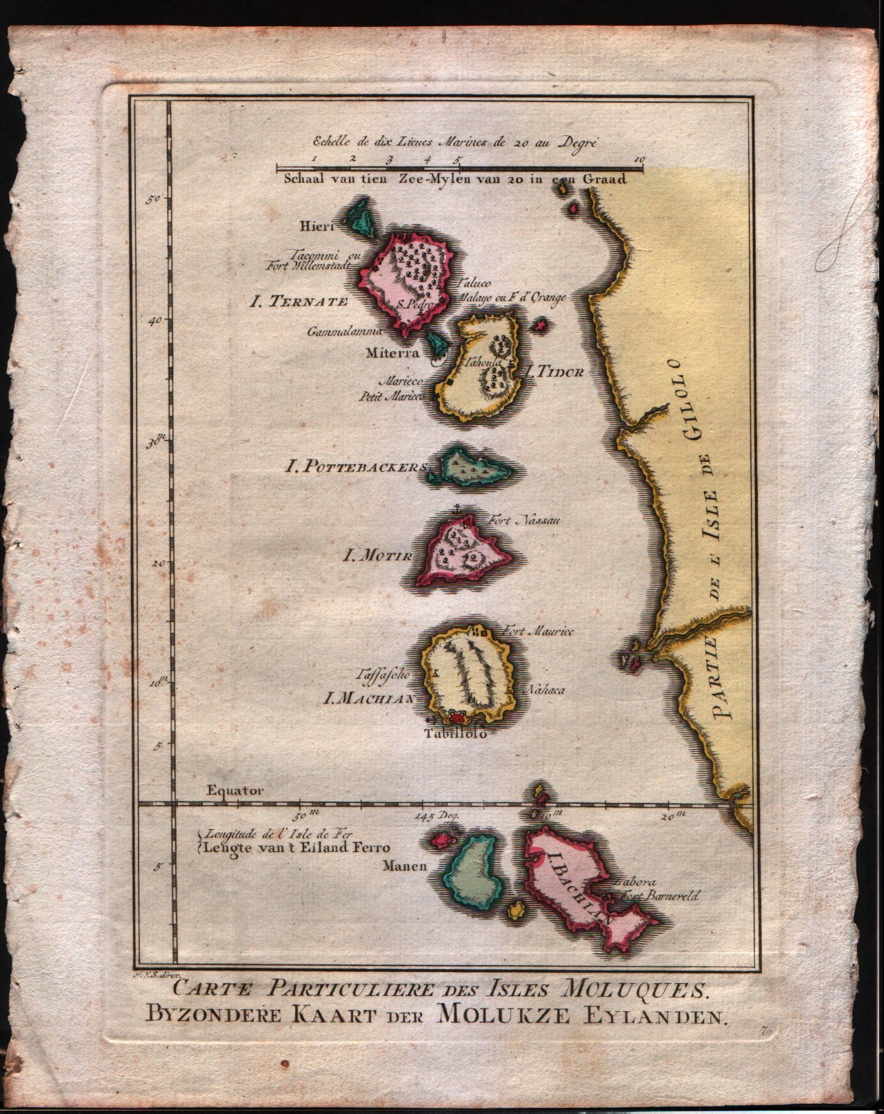
Map title
Carte particulier des isles Moluques
Mapmakers
Bellin
LocationLocation shown in map
Moluccas
Edition date
1757
Edition place
Paris
Editor
--
Atlas
Historie General des Voyages -- Prevost
Price
Please ask: info@thetreasuremaps.com
State
[mint/EXCELLENT/very good/good/fair/mediocre/poor]
Color
Black/white
Verso
Blank
Size
Plate: cm (15.2 x 21.6) inches (5.98 x 8.5) Paper: cm (16.5 x 22.9) inches (6.5 x 9.02)
Technique
Copper engraving
Note
No particular notes for this maps
Reference
--
Wiki
Here for more info
In stock
Available
Info
info@thetreasuremaps.com
Code
#0228
Carte particulier des isles Moluques
Mapmakers
Bellin
Moluccas
Edition date
1757
Edition place
Paris
Editor
--
Atlas
Historie General des Voyages -- Prevost
Price
Please ask: info@thetreasuremaps.com
State
[mint/EXCELLENT/very good/good/fair/mediocre/poor]
Color
Black/white
Verso
Blank
Size
Plate: cm (15.2 x 21.6) inches (5.98 x 8.5) Paper: cm (16.5 x 22.9) inches (6.5 x 9.02)
Technique
Copper engraving
Note
No particular notes for this maps
Reference
--
Wiki
Here for more info
In stock
Available
Info
info@thetreasuremaps.com
Code
#0228
×
![]()
Map title
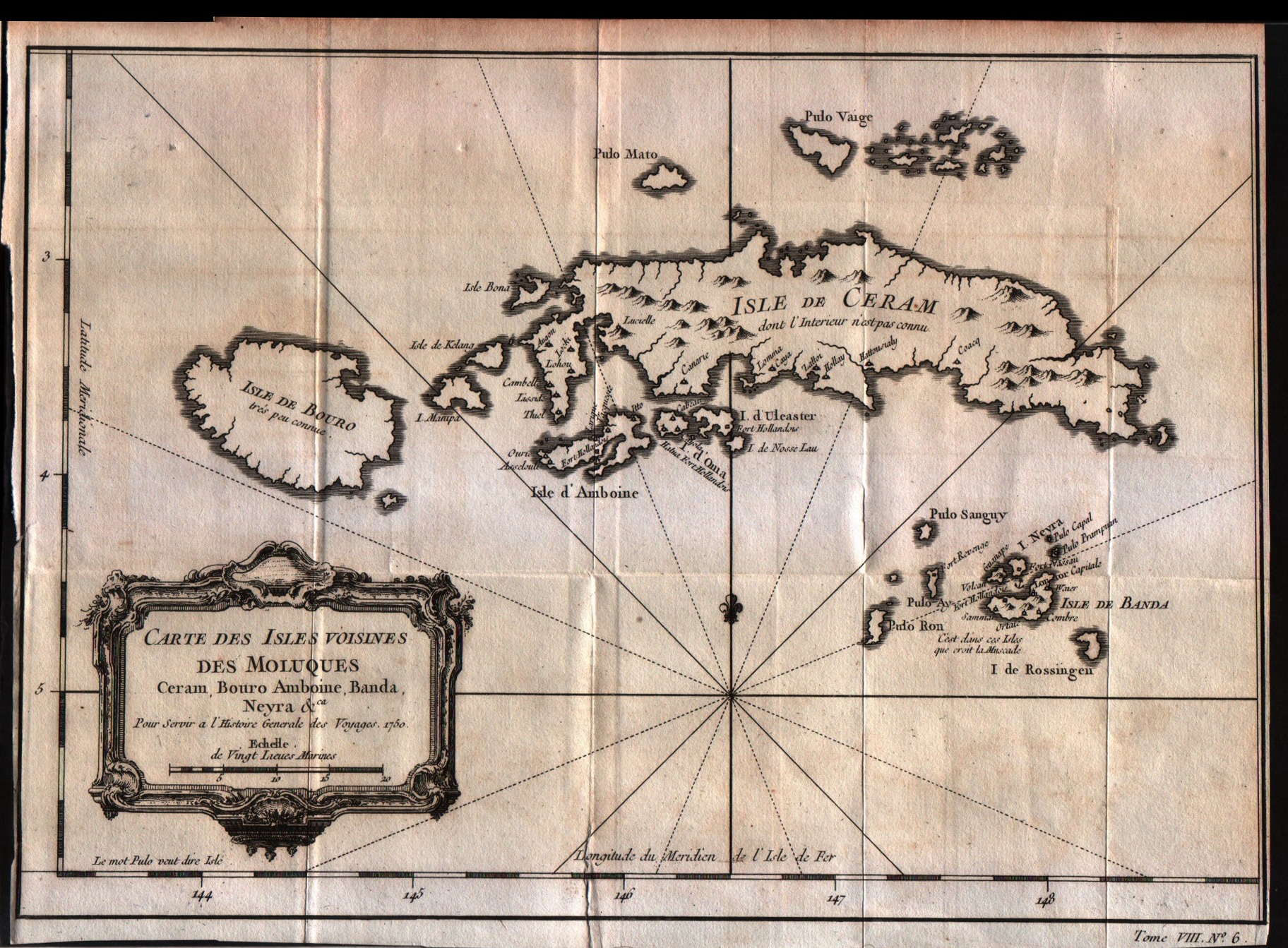
Carte des isles voisines des Moluques Ceram,Bouro,Amboine,Banda Neyra
Mapmakers
Bellin
LocationLocation shown in map
Ceram
Edition date
1757
Edition place
Paris
Editor
--
Atlas
Historie General des Voyages -- Prevost
Price
Please ask: info@thetreasuremaps.com
State
[mint/EXCELLENT/very good/good/fair/mediocre/poor]
Color
Black/white
Verso
Blank
Size
Plate: cm (29.2 x 20.3) inches (11.5 x 7.99) Paper: cm (30.5 x 21.6) inches (12.01 x 8.5)
Technique
Copper engraving
Note
No particular notes for this maps
Reference
--
Wiki
Here for more info
In stock
Available
Info
info@thetreasuremaps.com
Code
#0230
Carte des isles voisines des Moluques Ceram,Bouro,Amboine,Banda Neyra
Mapmakers
Bellin
Ceram
Edition date
1757
Edition place
Paris
Editor
--
Atlas
Historie General des Voyages -- Prevost
Price
Please ask: info@thetreasuremaps.com
State
[mint/EXCELLENT/very good/good/fair/mediocre/poor]
Color
Black/white
Verso
Blank
Size
Plate: cm (29.2 x 20.3) inches (11.5 x 7.99) Paper: cm (30.5 x 21.6) inches (12.01 x 8.5)
Technique
Copper engraving
Note
No particular notes for this maps
Reference
--
Wiki
Here for more info
In stock
Available
Info
info@thetreasuremaps.com
Code
#0230
×
![]()
Map title
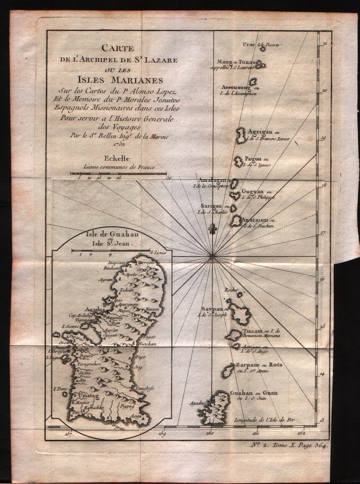
Carte de l'archipel de St.Lazare ou les isles Marianes
Mapmakers
Bellin
LocationLocation shown in map
Mariana Islands
Edition date
1757
Edition place
Paris
Editor
--
Atlas
Historie General des Voyages -- Prevost
Price
Please ask: info@thetreasuremaps.com
State
[mint/EXCELLENT/very good/good/fair/mediocre/poor]
Color
Black/white
Verso
Blank
Size
Plate: cm (15.2 x 22.9) inches (5.98 x 9.02) Paper: cm (17.8 x 25.4) inches (7.01 x 10)
Technique
Copper engraving
Note
No particular notes for this maps
Reference
--
Wiki
Here for more info
In stock
Available
Info
info@thetreasuremaps.com
Code
#0231
Carte de l'archipel de St.Lazare ou les isles Marianes
Mapmakers
Bellin
Mariana Islands
Edition date
1757
Edition place
Paris
Editor
--
Atlas
Historie General des Voyages -- Prevost
Price
Please ask: info@thetreasuremaps.com
State
[mint/EXCELLENT/very good/good/fair/mediocre/poor]
Color
Black/white
Verso
Blank
Size
Plate: cm (15.2 x 22.9) inches (5.98 x 9.02) Paper: cm (17.8 x 25.4) inches (7.01 x 10)
Technique
Copper engraving
Note
No particular notes for this maps
Reference
--
Wiki
Here for more info
In stock
Available
Info
info@thetreasuremaps.com
Code
#0231
×
![]()
Map title
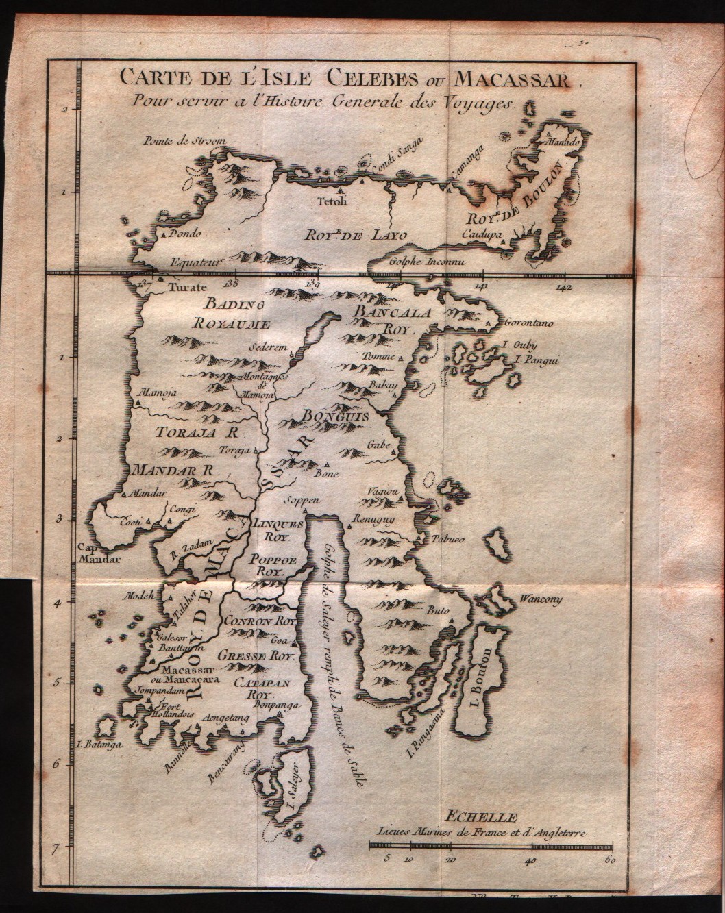
Carte de l'isle Celebes ou Macassar
Mapmakers
Bellin
LocationLocation shown in map
Celebes
Edition date
1757
Edition place
Paris
Editor
--
Atlas
Historie General des Voyages -- Prevost
Price
Please ask: info@thetreasuremaps.com
State
[mint/EXCELLENT/very good/good/fair/mediocre/poor]
Color
Black/white
Verso
Blank
Size
Plate: cm (15.2 x 19) inches (5.98 x 7.48) Paper: cm (17.8 x 21.6) inches (7.01 x 8.5)
Technique
Copper engraving
Note
No particular notes for this maps
Reference
--
Wiki
Here for more info
In stock
Available
Info
info@thetreasuremaps.com
Code
#0232
Carte de l'isle Celebes ou Macassar
Mapmakers
Bellin
Celebes
Edition date
1757
Edition place
Paris
Editor
--
Atlas
Historie General des Voyages -- Prevost
Price
Please ask: info@thetreasuremaps.com
State
[mint/EXCELLENT/very good/good/fair/mediocre/poor]
Color
Black/white
Verso
Blank
Size
Plate: cm (15.2 x 19) inches (5.98 x 7.48) Paper: cm (17.8 x 21.6) inches (7.01 x 8.5)
Technique
Copper engraving
Note
No particular notes for this maps
Reference
--
Wiki
Here for more info
In stock
Available
Info
info@thetreasuremaps.com
Code
#0232
×
![]()
Map title
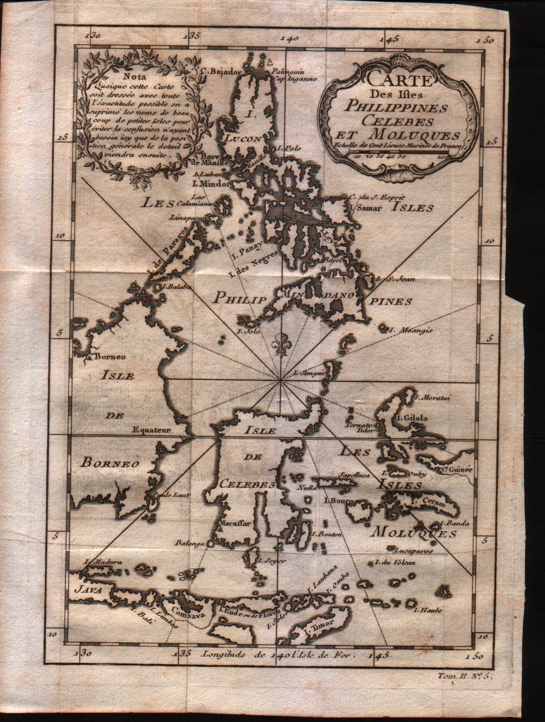
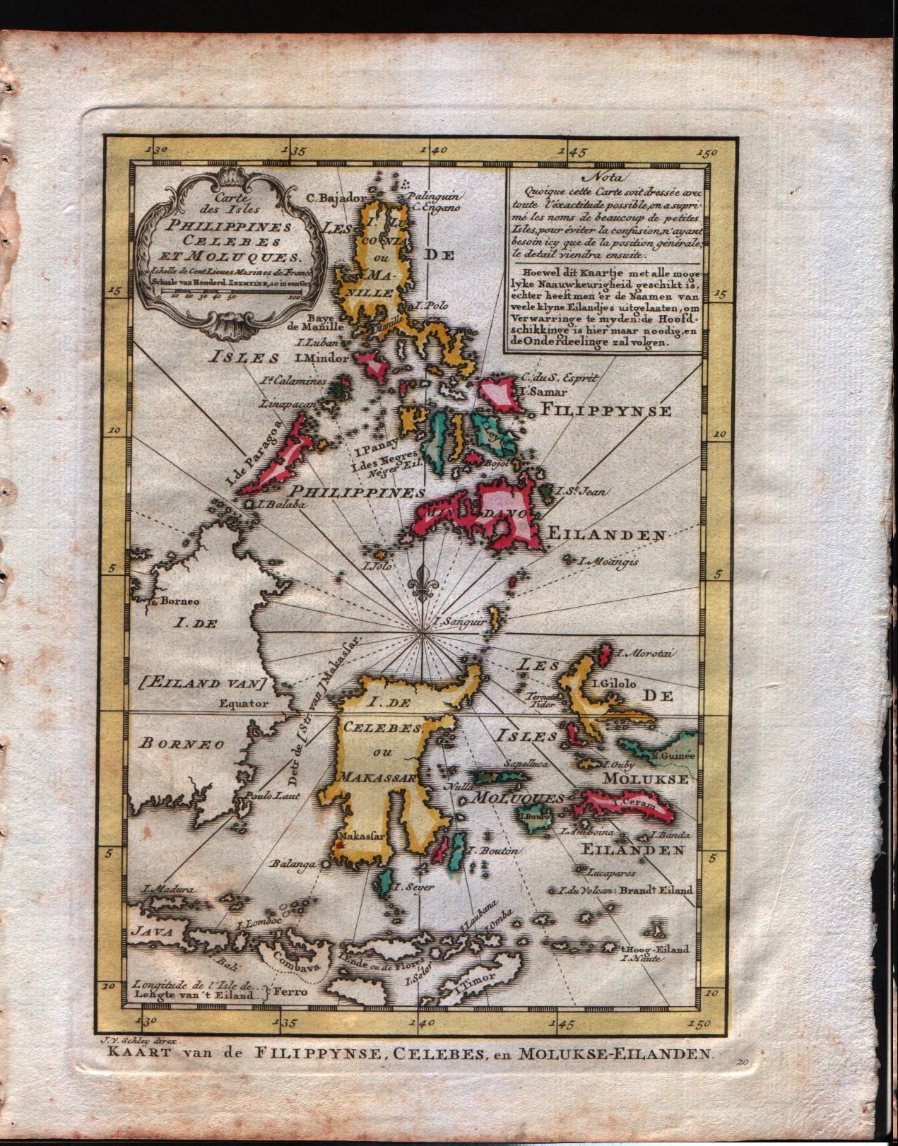
Carte des Isles Philippines Celebes et Moluques
Mapmakers
Bellin
LocationLocation shown in map
--
Edition date
1757
Edition place
Paris
Editor
--
Atlas
Historie General des Voyages -- Prevost
Price
Please ask: info@thetreasuremaps.com
State
[mint/EXCELLENT/very good/good/fair/mediocre/poor]
Color
Black/white
Verso
Blank
Size
Plate: cm (15.2 x 21.6) inches (5.98 x 8.5) Paper: cm (17.8 x 25.4) inches (7.01 x 10)
Technique
Copper engraving
Note
No particular notes for this maps
Reference
--
Wiki
Here for more info
In stock
Available
Info
info@thetreasuremaps.com
Code
#0233
Carte des Isles Philippines Celebes et Moluques
Mapmakers
Bellin
--
Edition date
1757
Edition place
Paris
Editor
--
Atlas
Historie General des Voyages -- Prevost
Price
Please ask: info@thetreasuremaps.com
State
[mint/EXCELLENT/very good/good/fair/mediocre/poor]
Color
Black/white
Verso
Blank
Size
Plate: cm (15.2 x 21.6) inches (5.98 x 8.5) Paper: cm (17.8 x 25.4) inches (7.01 x 10)
Technique
Copper engraving
Note
No particular notes for this maps
Reference
--
Wiki
Here for more info
In stock
Available
Info
info@thetreasuremaps.com
Code
#0233
×
![]()
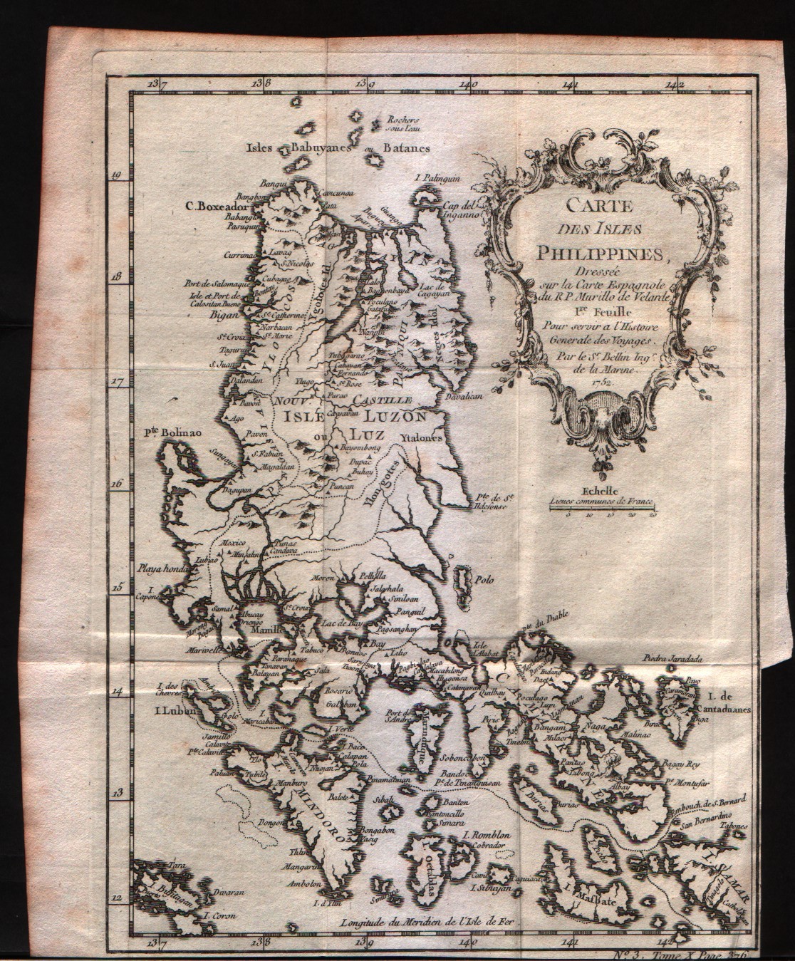
Map title
Carte des Isles Philippines 1Feuille
Mapmakers
Bellin
LocationLocation shown in map
--
Edition date
1757
Edition place
Paris
Editor
--
Atlas
Historie General des Voyages -- Prevost
Price
Please ask: info@thetreasuremaps.com
State
[mint/EXCELLENT/very good/good/fair/mediocre/poor]
Color
Black/white
Verso
Blank
Size
Plate: cm (15.2 x 20.3) inches (5.98 x 7.99) Paper: cm (17.8 x 21.6) inches (7.01 x 8.5)
Technique
Copper engraving
Note
No particular notes for this maps
Reference
--
Wiki
Here for more info
In stock
Available
Info
info@thetreasuremaps.com
Code
#0234
Carte des Isles Philippines 1Feuille
Mapmakers
Bellin
--
Edition date
1757
Edition place
Paris
Editor
--
Atlas
Historie General des Voyages -- Prevost
Price
Please ask: info@thetreasuremaps.com
State
[mint/EXCELLENT/very good/good/fair/mediocre/poor]
Color
Black/white
Verso
Blank
Size
Plate: cm (15.2 x 20.3) inches (5.98 x 7.99) Paper: cm (17.8 x 21.6) inches (7.01 x 8.5)
Technique
Copper engraving
Note
No particular notes for this maps
Reference
--
Wiki
Here for more info
In stock
Available
Info
info@thetreasuremaps.com
Code
#0234
×
![]()
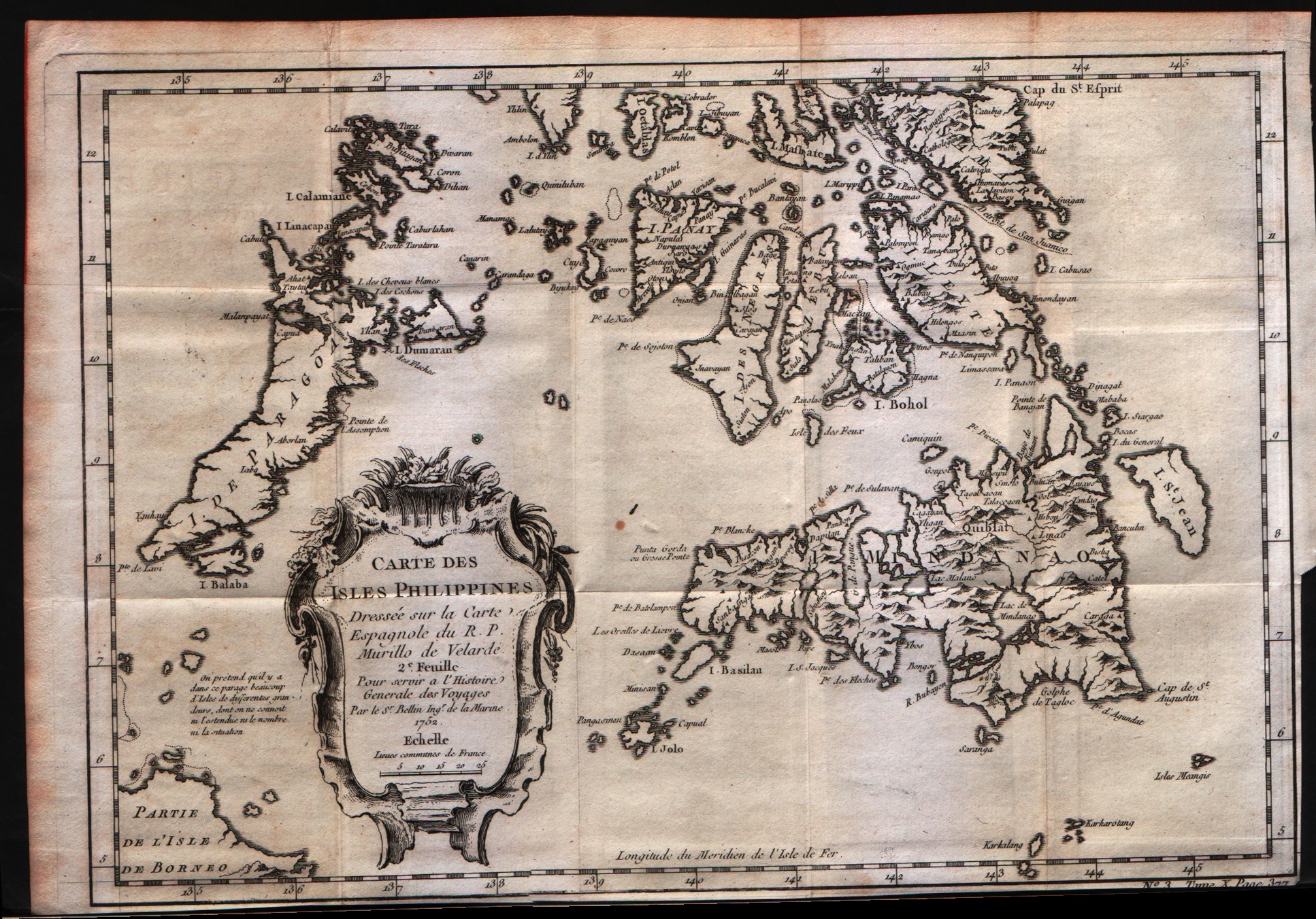
Map title
Carte des Isles Philippines 2Feuille
Mapmakers
Bellin
LocationLocation shown in map
--
Edition date
1757
Edition place
Paris
Editor
--
Atlas
Historie General des Voyages -- Prevost
Price
Please ask: info@thetreasuremaps.com
State
[mint/EXCELLENT/very good/good/fair/mediocre/poor]
Color
Black/white
Verso
Blank
Size
Plate: cm (30.5 x 20.3) inches (12.01 x 7.99) Paper: cm (31.8 x 22.9) inches (12.52 x 9.02)
Technique
Copper engraving
Note
No particular notes for this maps
Reference
--
Wiki
Here for more info
In stock
Available
Info
info@thetreasuremaps.com
Code
#0235
Carte des Isles Philippines 2Feuille
Mapmakers
Bellin
--
Edition date
1757
Edition place
Paris
Editor
--
Atlas
Historie General des Voyages -- Prevost
Price
Please ask: info@thetreasuremaps.com
State
[mint/EXCELLENT/very good/good/fair/mediocre/poor]
Color
Black/white
Verso
Blank
Size
Plate: cm (30.5 x 20.3) inches (12.01 x 7.99) Paper: cm (31.8 x 22.9) inches (12.52 x 9.02)
Technique
Copper engraving
Note
No particular notes for this maps
Reference
--
Wiki
Here for more info
In stock
Available
Info
info@thetreasuremaps.com
Code
#0235
×
![]()
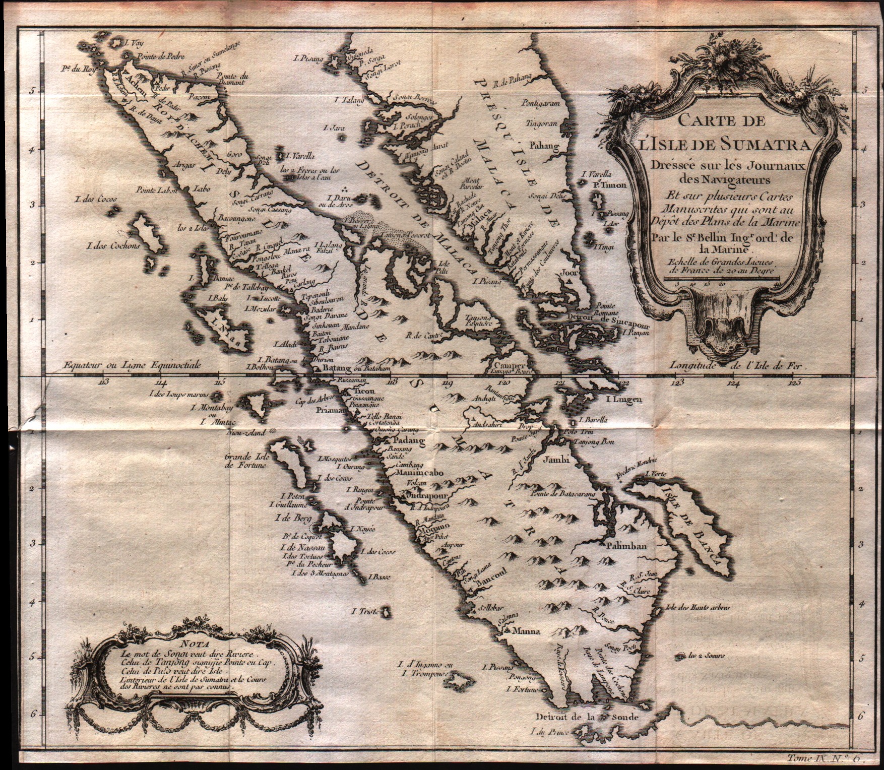
Map title
Carte De L'Isle De Sumatra
Mapmakers
Bellin
LocationLocation shown in map
--
Edition date
1757
Edition place
Paris
Editor
--
Atlas
Historie General des Voyages -- Prevost
Price
Please ask: info@thetreasuremaps.com
State
[mint/excellent/VERY GOOD/good/fair/mediocre/poor]
Color
Black/white
Verso
Blank
Size
Plate: cm (29.2 x 26.7) inches (11.5 x 10.51) Paper: cm (29.2 x 26) inches (11.5 x 10.24)
Technique
Copper engraving
Note
No particular notes for this maps
Reference
--
Wiki
Here for more info
In stock
Available
Info
info@thetreasuremaps.com
Code
#0241
Carte De L'Isle De Sumatra
Mapmakers
Bellin
--
Edition date
1757
Edition place
Paris
Editor
--
Atlas
Historie General des Voyages -- Prevost
Price
Please ask: info@thetreasuremaps.com
State
[mint/excellent/VERY GOOD/good/fair/mediocre/poor]
Color
Black/white
Verso
Blank
Size
Plate: cm (29.2 x 26.7) inches (11.5 x 10.51) Paper: cm (29.2 x 26) inches (11.5 x 10.24)
Technique
Copper engraving
Note
No particular notes for this maps
Reference
--
Wiki
Here for more info
In stock
Available
Info
info@thetreasuremaps.com
Code
#0241
×
![]()
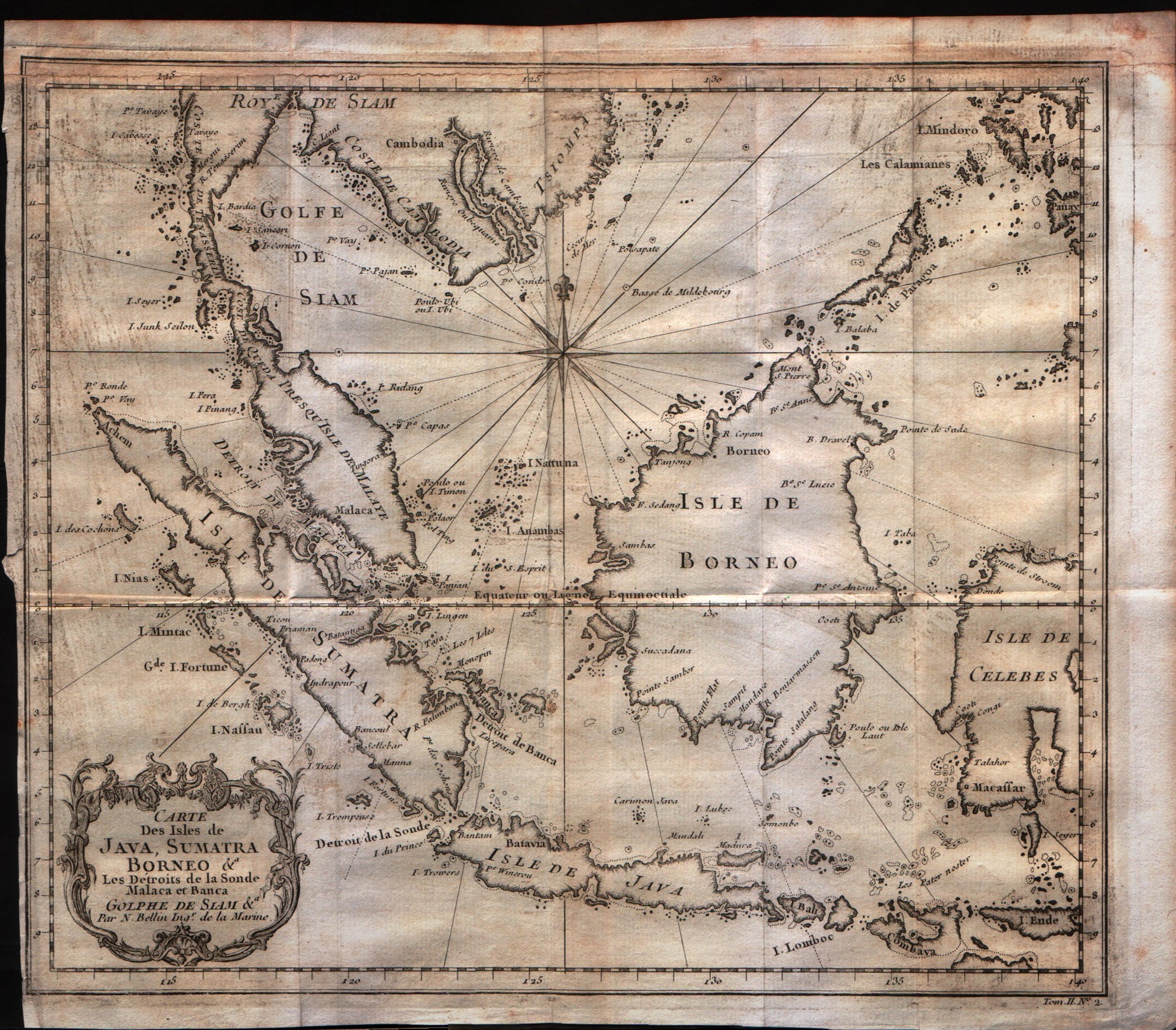
Map title
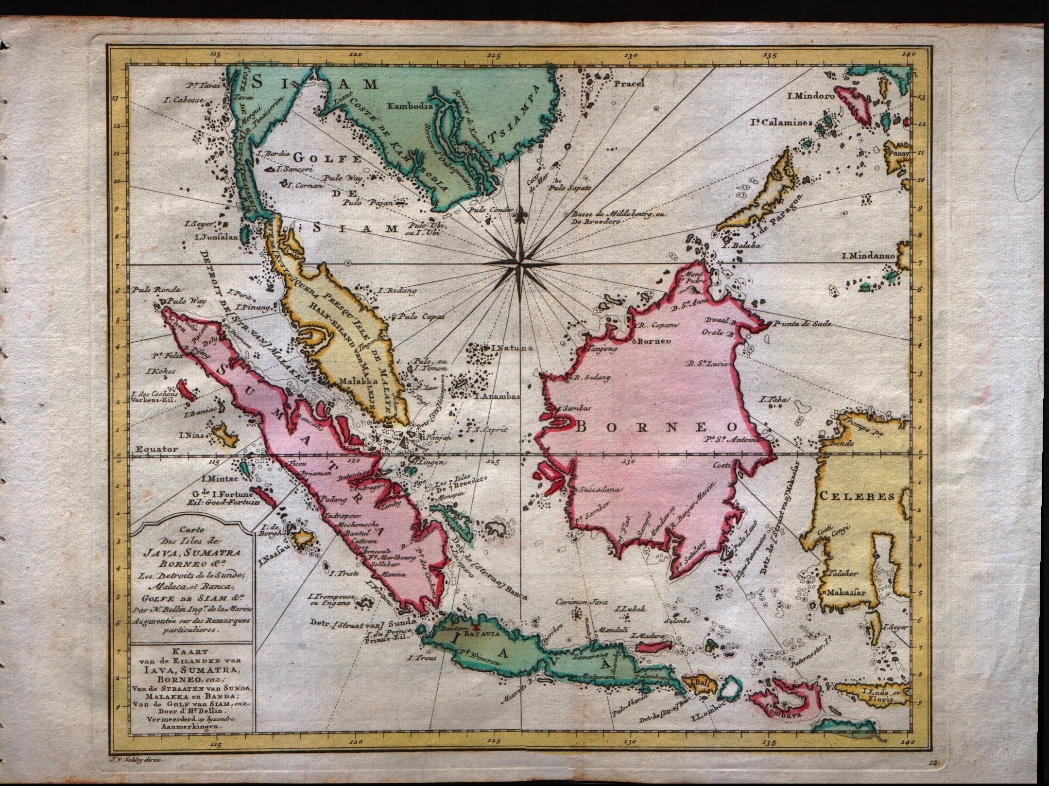
Carte Des Isles De Java, Sumatra Borneo
Mapmakers
Bellin
LocationLocation shown in map
--
Edition date
1757
Edition place
Paris
Editor
--
Atlas
Historie General des Voyages -- Prevost
Price
Please ask: info@thetreasuremaps.com
State
[mint/excellent/VERY GOOD/good/fair/mediocre/poor]
Color
Black/white
Verso
Blank
Size
Plate: cm (29.2 x 24.1) inches (11.5 x 9.49) Paper: cm (30.5 x 26.7) inches (12.01 x 10.51)
Technique
Copper engraving
Note
No particular notes for this maps
Reference
--
Wiki
Here for more info
In stock
Available
Info
info@thetreasuremaps.com
Code
#0247
Carte Des Isles De Java, Sumatra Borneo
Mapmakers
Bellin
--
Edition date
1757
Edition place
Paris
Editor
--
Atlas
Historie General des Voyages -- Prevost
Price
Please ask: info@thetreasuremaps.com
State
[mint/excellent/VERY GOOD/good/fair/mediocre/poor]
Color
Black/white
Verso
Blank
Size
Plate: cm (29.2 x 24.1) inches (11.5 x 9.49) Paper: cm (30.5 x 26.7) inches (12.01 x 10.51)
Technique
Copper engraving
Note
No particular notes for this maps
Reference
--
Wiki
Here for more info
In stock
Available
Info
info@thetreasuremaps.com
Code
#0247
×
![]()
Map title
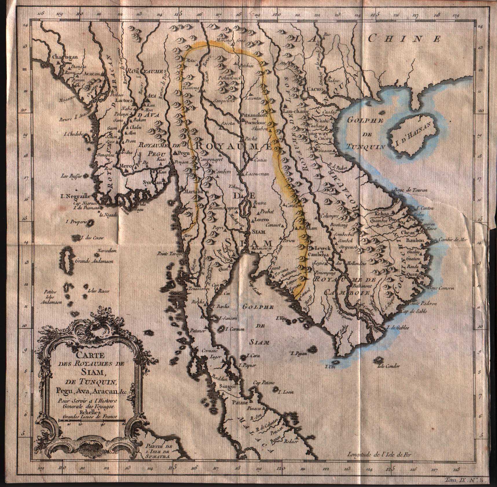
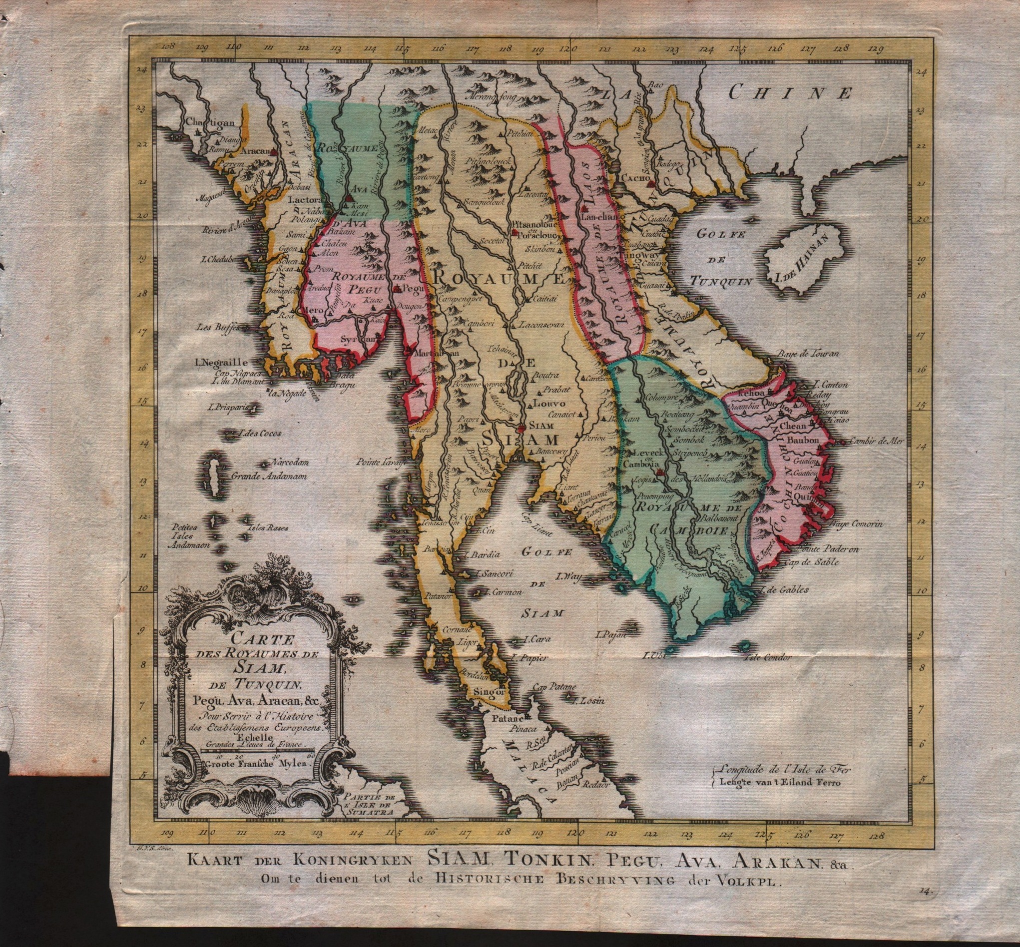
Carte des royaumes de Siam de Tunquin, Pegu, Ava, Aracan
Mapmakers
Bellin
LocationLocation shown in map
--
Edition date
1757
Edition place
Paris
Editor
--
Atlas
Historie General des Voyages -- Prevost
Price
Please ask: info@thetreasuremaps.com
State
[mint/excellent/very good/GOOD/fair/mediocre/poor]
Color
Black/white
Verso
Blank
Size
Plate: cm (27.9 x 27.9) inches (10.98 x 10.98) Paper: cm (28.6 x 28.6) inches (11.26 x 11.26)
Technique
Copper engraving
Note
No particular notes for this maps
Reference
--
Wiki
Here for more info
In stock
Available
Info
info@thetreasuremaps.com
Code
#0250
Carte des royaumes de Siam de Tunquin, Pegu, Ava, Aracan
Mapmakers
Bellin
--
Edition date
1757
Edition place
Paris
Editor
--
Atlas
Historie General des Voyages -- Prevost
Price
Please ask: info@thetreasuremaps.com
State
[mint/excellent/very good/GOOD/fair/mediocre/poor]
Color
Black/white
Verso
Blank
Size
Plate: cm (27.9 x 27.9) inches (10.98 x 10.98) Paper: cm (28.6 x 28.6) inches (11.26 x 11.26)
Technique
Copper engraving
Note
No particular notes for this maps
Reference
--
Wiki
Here for more info
In stock
Available
Info
info@thetreasuremaps.com
Code
#0250
×
![]()
Map title
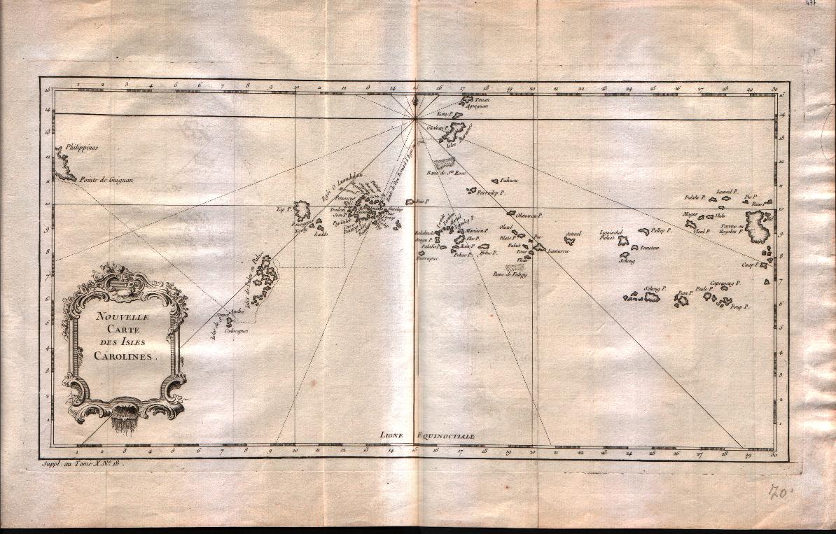
Nouvelle carte des isles Carolines
Mapmakers
Bellin
LocationLocation shown in map
Caroline islands
Edition date
1757
Edition place
Paris
Editor
--
Atlas
Historie General des Voyages -- Prevost
Price
Please ask: info@thetreasuremaps.com
State
[mint/EXCELLENT/very good/good/fair/mediocre/poor]
Color
Black/white
Verso
Blank
Size
Plate: cm (38.1 x 20.3) inches (15 x 7.99) Paper: cm (43.2 x 27.9) inches (17.01 x 10.98)
Technique
Copper engraving
Note
No particular notes for this maps
Reference
--
Wiki
Here for more info
In stock
Available
Info
info@thetreasuremaps.com
Code
#0251
Nouvelle carte des isles Carolines
Mapmakers
Bellin
Caroline islands
Edition date
1757
Edition place
Paris
Editor
--
Atlas
Historie General des Voyages -- Prevost
Price
Please ask: info@thetreasuremaps.com
State
[mint/EXCELLENT/very good/good/fair/mediocre/poor]
Color
Black/white
Verso
Blank
Size
Plate: cm (38.1 x 20.3) inches (15 x 7.99) Paper: cm (43.2 x 27.9) inches (17.01 x 10.98)
Technique
Copper engraving
Note
No particular notes for this maps
Reference
--
Wiki
Here for more info
In stock
Available
Info
info@thetreasuremaps.com
Code
#0251
×
![]()

Map title
Suite De L'Ocean Oriental contenant les isles del la Sonde les costes de Tunquin et de la Chine les isles du Japon les Philippines Moluques.
Mapmakers
Bellin
LocationLocation shown in map
--
Edition date
1757
Edition place
Paris
Editor
--
Atlas
Historie General des Voyages -- Prevost
Price
Please ask: info@thetreasuremaps.com
State
[mint/excellent/VERY GOOD/good/fair/mediocre/poor]
Color
Black/white
Verso
Blank
Size
Plate: cm (29.8 x 29.2) inches (11.73 x 11.5) Paper: cm (33.7 x 32.4) inches (13.27 x 12.76)
Technique
Copper engraving
Note
Note the unusual outlines of Japan and Korea. And the not well known Nouvelle Guinee
Reference
--
Wiki
Here for more info
In stock
Sold
Info
info@thetreasuremaps.com
Code
#0452
Suite De L'Ocean Oriental contenant les isles del la Sonde les costes de Tunquin et de la Chine les isles du Japon les Philippines Moluques.
Mapmakers
Bellin
--
Edition date
1757
Edition place
Paris
Editor
--
Atlas
Historie General des Voyages -- Prevost
Price
Please ask: info@thetreasuremaps.com
State
[mint/excellent/VERY GOOD/good/fair/mediocre/poor]
Color
Black/white
Verso
Blank
Size
Plate: cm (29.8 x 29.2) inches (11.73 x 11.5) Paper: cm (33.7 x 32.4) inches (13.27 x 12.76)
Technique
Copper engraving
Note
Note the unusual outlines of Japan and Korea. And the not well known Nouvelle Guinee
Reference
--
Wiki
Here for more info
In stock
Sold
Info
info@thetreasuremaps.com
Code
#0452
×
![]()
Map title
Carte des Isles Philippines Celebes et Moluques
Mapmakers
Bellin
LocationLocation shown in map
--
Edition date
1773
Edition place
Amsterdam
Editor
--
Atlas
Atlas Portatif -- E. van Harrevelt
Price
Please ask: info@thetreasuremaps.com
State
[mint/EXCELLENT/very good/good/fair/mediocre/poor]
Color
Old outlined
Verso
Blank
Size
Plate: cm (15.2 x 21.6) inches (5.98 x 8.5) Paper: cm (21.6 x 26.7) inches (8.5 x 10.51)
Technique
Copper engraving
Note
No particular notes for this maps
Reference
--
Wiki
Here for more info
In stock
Available
Info
info@thetreasuremaps.com
Code
#0259
Carte des Isles Philippines Celebes et Moluques
Mapmakers
Bellin
--
Edition date
1773
Edition place
Amsterdam
Editor
--
Atlas
Atlas Portatif -- E. van Harrevelt
Price
Please ask: info@thetreasuremaps.com
State
[mint/EXCELLENT/very good/good/fair/mediocre/poor]
Color
Old outlined
Verso
Blank
Size
Plate: cm (15.2 x 21.6) inches (5.98 x 8.5) Paper: cm (21.6 x 26.7) inches (8.5 x 10.51)
Technique
Copper engraving
Note
No particular notes for this maps
Reference
--
Wiki
Here for more info
In stock
Available
Info
info@thetreasuremaps.com
Code
#0259
×
![]()
Map title
Carte particulier des Isles Moluques
Mapmakers
Bellin
LocationLocation shown in map
--
Edition date
1773
Edition place
Amsterdam
Editor
--
Atlas
Atlas Portatif -- E. van Harrevelt
Price
Please ask: info@thetreasuremaps.com
State
[mint/EXCELLENT/very good/good/fair/mediocre/poor]
Color
Old colors
Verso
Blank
Size
Plate: cm (15.2 x 21.6) inches (5.98 x 8.5) Paper: cm (21.6 x 26.7) inches (8.5 x 10.51)
Technique
Copper engraving
Note
No particular notes for this maps
Reference
--
Wiki
Here for more info
In stock
Available
Info
info@thetreasuremaps.com
Code
#0260
Carte particulier des Isles Moluques
Mapmakers
Bellin
--
Edition date
1773
Edition place
Amsterdam
Editor
--
Atlas
Atlas Portatif -- E. van Harrevelt
Price
Please ask: info@thetreasuremaps.com
State
[mint/EXCELLENT/very good/good/fair/mediocre/poor]
Color
Old colors
Verso
Blank
Size
Plate: cm (15.2 x 21.6) inches (5.98 x 8.5) Paper: cm (21.6 x 26.7) inches (8.5 x 10.51)
Technique
Copper engraving
Note
No particular notes for this maps
Reference
--
Wiki
Here for more info
In stock
Available
Info
info@thetreasuremaps.com
Code
#0260
×
![]()
Map title
Nouvelle carte de l'isle de Java
Mapmakers
Unknown
LocationLocation shown in map
--
Edition date
1773
Edition place
Amsterdam
Editor
--
Atlas
Atlas Portatif -- E. van Harrevelt
Price
Please ask: info@thetreasuremaps.com
State
[mint/EXCELLENT/very good/good/fair/mediocre/poor]
Color
Old colors
Verso
Blank
Size
Plate: cm (43.2 x 20.3) inches (17.01 x 7.99) Paper: cm (53.3 x 26.7) inches (20.98 x 10.51)
Technique
Copper engraving
Note
No particular notes for this maps
Reference
--
Wiki
Here for more info
In stock
Available
Info
info@thetreasuremaps.com
Code
#0262
Nouvelle carte de l'isle de Java
Mapmakers
Unknown
--
Edition date
1773
Edition place
Amsterdam
Editor
--
Atlas
Atlas Portatif -- E. van Harrevelt
Price
Please ask: info@thetreasuremaps.com
State
[mint/EXCELLENT/very good/good/fair/mediocre/poor]
Color
Old colors
Verso
Blank
Size
Plate: cm (43.2 x 20.3) inches (17.01 x 7.99) Paper: cm (53.3 x 26.7) inches (20.98 x 10.51)
Technique
Copper engraving
Note
No particular notes for this maps
Reference
--
Wiki
Here for more info
In stock
Available
Info
info@thetreasuremaps.com
Code
#0262
×
![]()
Map title
Carte des royaumes de Siam de Tunquin, Pegu, Ava, Aracan
Mapmakers
Bellin
LocationLocation shown in map
--
Edition date
1773
Edition place
Amsterdam
Editor
--
Atlas
Atlas Portatif -- E. van Harrevelt
Price
Please ask: info@thetreasuremaps.com
State
[mint/EXCELLENT/very good/good/fair/mediocre/poor]
Color
Old colors
Verso
Blank
Size
Plate: cm (27.9 x 27.9) inches (10.98 x 10.98) Paper: cm (35.6 x 31.8) inches (14.02 x 12.52)
Technique
Copper engraving
Note
No particular notes for this maps
Reference
--
Wiki
Here for more info
In stock
Available
Info
info@thetreasuremaps.com
Code
#0263
Carte des royaumes de Siam de Tunquin, Pegu, Ava, Aracan
Mapmakers
Bellin
--
Edition date
1773
Edition place
Amsterdam
Editor
--
Atlas
Atlas Portatif -- E. van Harrevelt
Price
Please ask: info@thetreasuremaps.com
State
[mint/EXCELLENT/very good/good/fair/mediocre/poor]
Color
Old colors
Verso
Blank
Size
Plate: cm (27.9 x 27.9) inches (10.98 x 10.98) Paper: cm (35.6 x 31.8) inches (14.02 x 12.52)
Technique
Copper engraving
Note
No particular notes for this maps
Reference
--
Wiki
Here for more info
In stock
Available
Info
info@thetreasuremaps.com
Code
#0263
×
![]()
Map title
Carte Des Isles De Java, Sumatra Borneo
Mapmakers
Bellin
LocationLocation shown in map
--
Edition date
1773
Edition place
Amsterdam
Editor
--
Atlas
Atlas Portatif -- E. van Harrevelt
Price
Please ask: info@thetreasuremaps.com
State
[mint/EXCELLENT/very good/good/fair/mediocre/poor]
Color
Old colors
Verso
Blank
Size
Plate: cm (29.2 x 24.1) inches (11.5 x 9.49) Paper: cm (35.6 x 26.7) inches (14.02 x 10.51)
Technique
Copper engraving
Note
No particular notes for this maps
Reference
--
Wiki
Here for more info
In stock
Available
Info
info@thetreasuremaps.com
Code
#0267
Carte Des Isles De Java, Sumatra Borneo
Mapmakers
Bellin
--
Edition date
1773
Edition place
Amsterdam
Editor
--
Atlas
Atlas Portatif -- E. van Harrevelt
Price
Please ask: info@thetreasuremaps.com
State
[mint/EXCELLENT/very good/good/fair/mediocre/poor]
Color
Old colors
Verso
Blank
Size
Plate: cm (29.2 x 24.1) inches (11.5 x 9.49) Paper: cm (35.6 x 26.7) inches (14.02 x 10.51)
Technique
Copper engraving
Note
No particular notes for this maps
Reference
--
Wiki
Here for more info
In stock
Available
Info
info@thetreasuremaps.com
Code
#0267
×
![]()
Map title
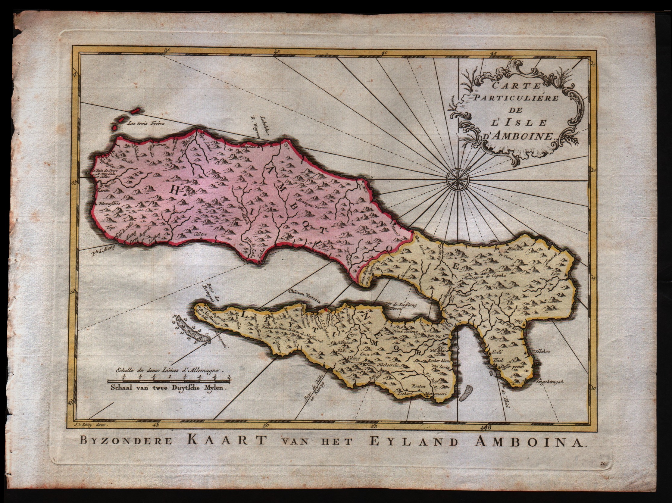
Carte particuli� de l'isle d'Amboine
Mapmakers
Bellin
LocationLocation shown in map
--
Edition date
1773
Edition place
Amsterdam
Editor
--
Atlas
Atlas Portatif -- E. van Harrevelt
Price
Please ask: info@thetreasuremaps.com
State
[mint/EXCELLENT/very good/good/fair/mediocre/poor]
Color
Old colors
Verso
Blank
Size
Plate: cm (29.2 x 21.6) inches (11.5 x 8.5) Paper: cm (35.6 x 26.7) inches (14.02 x 10.51)
Technique
Copper engraving
Note
No particular notes for this maps
Reference
--
Wiki
Here for more info
In stock
Available
Info
info@thetreasuremaps.com
Code
#0268
Carte particuli� de l'isle d'Amboine
Mapmakers
Bellin
--
Edition date
1773
Edition place
Amsterdam
Editor
--
Atlas
Atlas Portatif -- E. van Harrevelt
Price
Please ask: info@thetreasuremaps.com
State
[mint/EXCELLENT/very good/good/fair/mediocre/poor]
Color
Old colors
Verso
Blank
Size
Plate: cm (29.2 x 21.6) inches (11.5 x 8.5) Paper: cm (35.6 x 26.7) inches (14.02 x 10.51)
Technique
Copper engraving
Note
No particular notes for this maps
Reference
--
Wiki
Here for more info
In stock
Available
Info
info@thetreasuremaps.com
Code
#0268
×
![]()
Map title
Carte des environs de Batavia
Mapmakers
Bellin
LocationLocation shown in map
Batavia city
Edition date
1773
Edition place
Amsterdam
Editor
--
Atlas
Atlas Portatif -- E. van Harrevelt
Price
Please ask: info@thetreasuremaps.com
State
[mint/EXCELLENT/very good/good/fair/mediocre/poor]
Color
Old colors
Verso
Blank
Size
Plate: cm (27.9 x 22.9) inches (10.98 x 9.02) Paper: cm (35.6 x 25.4) inches (14.02 x 10)
Technique
Copper engraving
Note
No particular notes for this maps
Reference
--
Wiki
Here for more info
In stock
Sold
Info
info@thetreasuremaps.com
Code
#0275
Carte des environs de Batavia
Mapmakers
Bellin
Batavia city
Edition date
1773
Edition place
Amsterdam
Editor
--
Atlas
Atlas Portatif -- E. van Harrevelt
Price
Please ask: info@thetreasuremaps.com
State
[mint/EXCELLENT/very good/good/fair/mediocre/poor]
Color
Old colors
Verso
Blank
Size
Plate: cm (27.9 x 22.9) inches (10.98 x 9.02) Paper: cm (35.6 x 25.4) inches (14.02 x 10)
Technique
Copper engraving
Note
No particular notes for this maps
Reference
--
Wiki
Here for more info
In stock
Sold
Info
info@thetreasuremaps.com
Code
#0275
×
![]()