United States
Map title
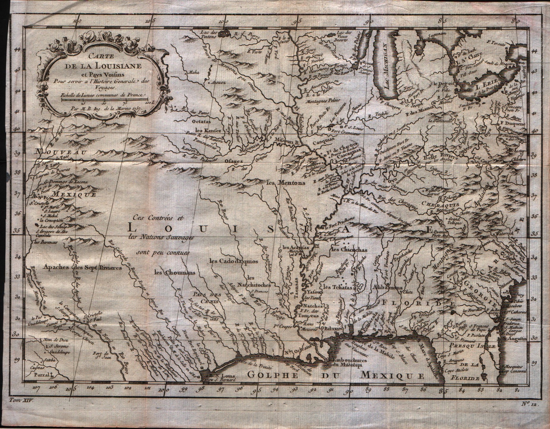
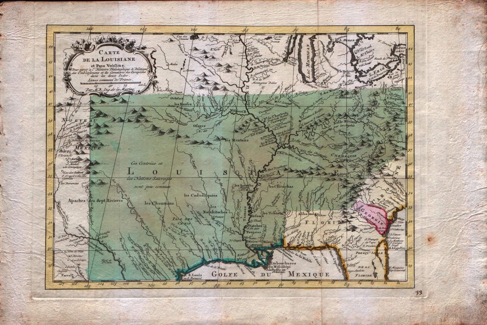
Carte de la Louisiane
Author
Bellin
Location shown in map
Louisiane
Edition date
1757
Edition place
Paris
Editor
--
Atlas
Historie General des Voyages -- Prevost
Price
350 Euro
State
[mint/excellent/VERY GOOD/good/fair/mediocre/poor]
Color
Black/white
Verso
Blank
Size
Plate: cm (30.5 x 21.6) inches (12.01 x 8.5) Paper: cm (30.5 x 24.1) inches (12.01 x 9.49)
Technique
Copper engraving
Note
Bellin notes all major river systems, especially the Mississippi system upon which their claims rested, and many of the French forts, including Detroit, Fort Duquesne (Pittsburgh), Fort de la Presque Isle (Erie), Sandoske, and Fort Checagou.
Reference
--
Wiki
Here for more info
In stock
Available
Info
info@thetreasuremaps.com
Code
#0059
×
![]()
Map title
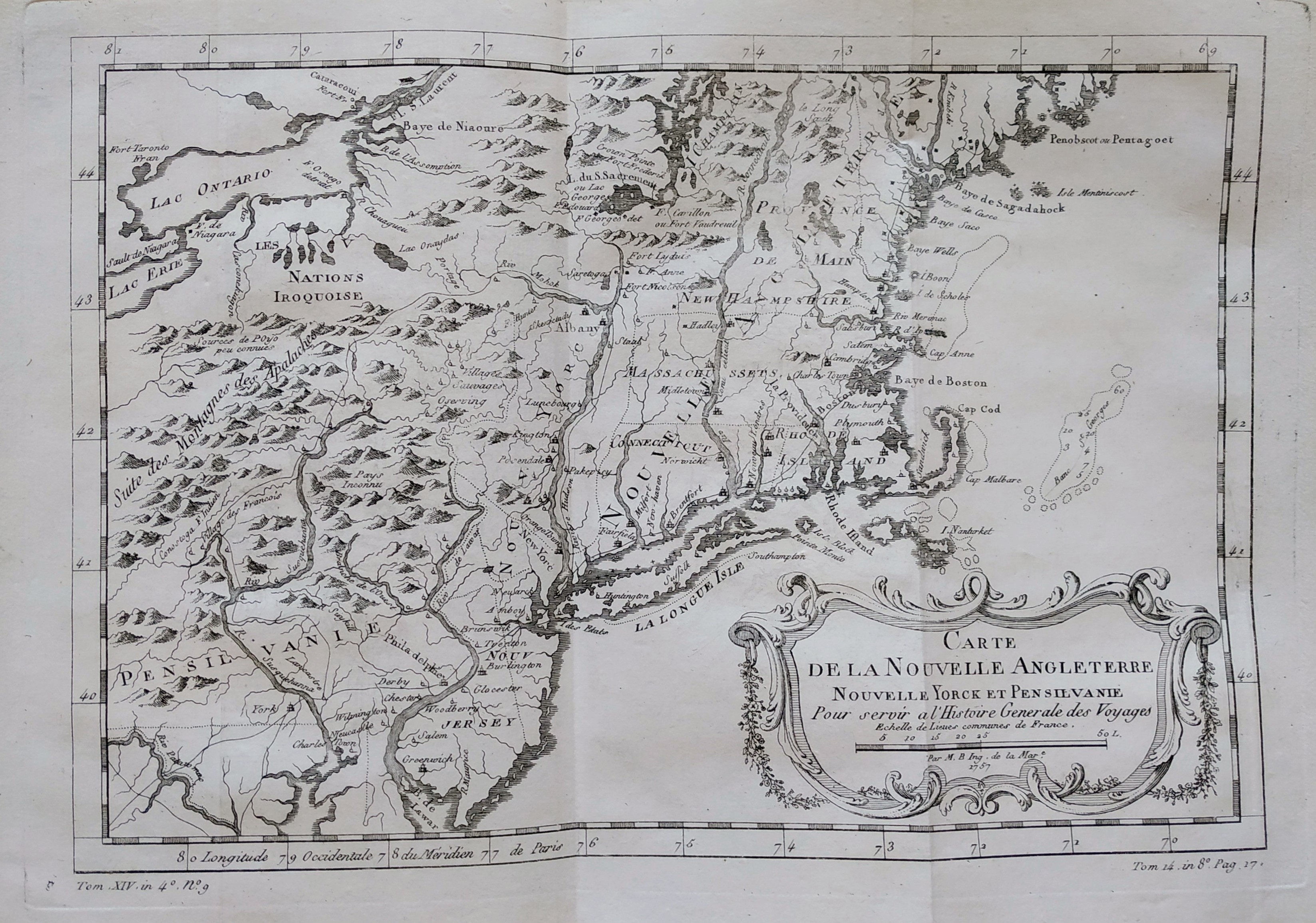
Carte de la nouvelle Angleterre
Author
Bellin
Location shown in map
New England
Edition date
1757
Edition place
Paris
Editor
Prevost
Atlas
Historie General des Voyages -- Prevost
Price
300 Euro
State
[mint/EXCELLENT/very good/good/fair/mediocre/poor]
Color
Black/white
Verso
Blank
Size
Plate: cm (29 x 20) inches (11.42 x 7.87) Paper: cm (37 x 25) inches (14.57 x 9.84)
Technique
Copper engraving
Note
The New England colonies are named except Vermont which is still the unnamed disputed territory between New Hampshire and New York. The area covered as a whole extends from Penobscot Bay south to Chesapeake Bay and west to Lake Erie. The map illustrates provinces, towns, forts, rivers, Native American lands and relief.
Reference
--
Wiki
Here for more info
In stock
Available
Info
info@thetreasuremaps.com
Code
#0762
×
![]()

Map title
Carte de la nouvelle Angleterre
Author
Bellin
Location shown in map
New England
Edition date
1757
Edition place
Paris
Editor
--
Atlas
Historie General des Voyages -- Prevost
Price
Please ask: info@thetreasuremaps.com
State
[mint/excellent/VERY GOOD/good/fair/mediocre/poor]On up-left missing 2mm
Color
Black/white
Verso
Blank
Size
Plate: cm (29.2 x 20.3) inches (11.5 x 7.99) Paper: cm (30.5 x 22.9) inches (12.01 x 9.02)
Technique
Copper engraving
Note
The New England colonies are named except Vermont which is still the unnamed disputed territory between New Hampshire and New York. The area covered as a whole extends from Penobscot Bay south to Chesapeake Bay and west to Lake Erie. The map illustrates provinces, towns, forts, rivers, Native American lands and relief.
Reference
--
Wiki
Here for more info
In stock
Sold
Info
info@thetreasuremaps.com
Code
#0404
×
![]()
Map title
Carte de la baye de Chesapeack et Pays Voisins
Author
Bellin
Location shown in map
--
Edition date
1757
Edition place
Paris
Editor
--
Atlas
Historie General des Voyages -- Prevost
Price
Please ask: info@thetreasuremaps.com
State
[mint/excellent/VERY GOOD/good/fair/mediocre/poor]
Color
Black/white
Verso
Blank
Size
Plate: cm (27.9 x 19) inches (10.98 x 7.48) Paper: cm (30.5 x 22.9) inches (12.01 x 9.02)
Technique
Copper engraving
Note
No particular notes for this maps
Reference
--
Wiki
Here for more info
In stock
Sold
Info
info@thetreasuremaps.com
Code
#0067
×
![]()
Map title
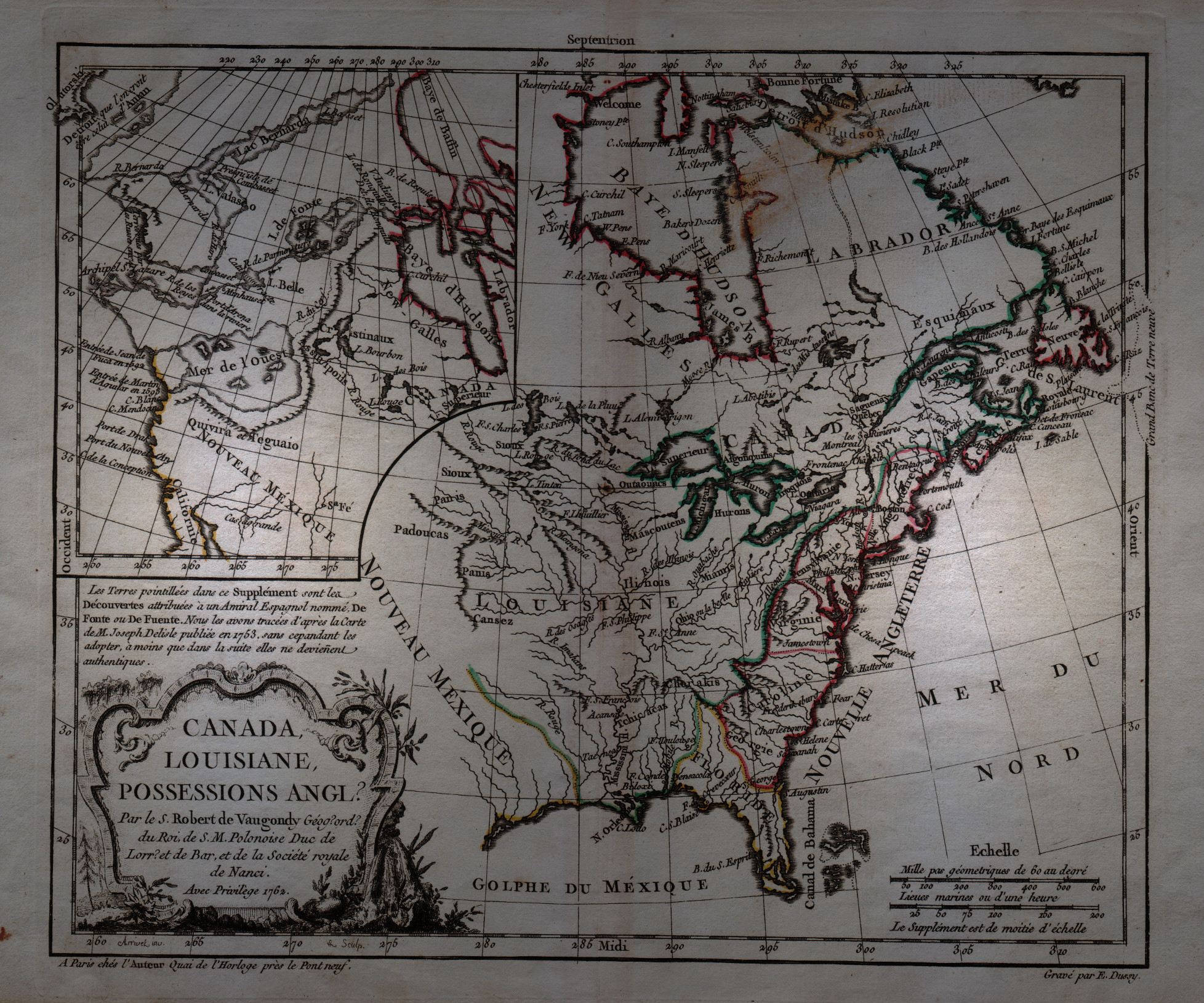
Canada, Louisiane, Possessions Anglais
Author
Robert de Vaugondy
Location shown in map
North America
Edition date
1762
Edition place
Paris
Editor
--
Atlas
Atlas Protatif
Price
300 Euro
State
[mint/EXCELLENT/very good/good/fair/mediocre/poor]
Color
Black/white
Verso
Blank
Size
Plate: cm (29.2 x 24.1) inches (11.5 x 9.49) Paper: cm (40.6 x 26.7) inches (15.98 x 10.51)
Technique
Copper engraving
Note
First state of this interesting map of the colonial possessions of England, France and Spain in North America. A large inset map covers the west coast and is most notable for its depiction of two remarkable cartographic misconceptions; a huge Mer de l' Ouest or Sea of the West and a Northwest Passage through a system of rivers and lakes connecting Hudson Bay with the Pacific based on the fictitious discoveries of Admiral de Font.
Reference
--
Wiki
Here for more info
In stock
Available
Info
info@thetreasuremaps.com
Code
#0058
×
![]()
Map title
Carte de la Louisiane
Author
Bellin
Location shown in map
Louisiane
Edition date
1773
Edition place
Amsterdam
Editor
--
Atlas
Atlas Portatif -- E. van Harrevelt
Price
350 Euro
State
[mint/EXCELLENT/very good/good/fair/mediocre/poor]
Color
Old colors
Verso
Blank
Size
Plate: cm (30.5 x 21.6) inches (12.01 x 8.5) Paper: cm (39.4 x 26.7) inches (15.51 x 10.51)
Technique
Copper engraving
Note
Bellin notes all major river systems, especially the Mississippi system upon which their claims rested, and many of the French forts, including Detroit, Fort Duquesne (Pittsburgh), Fort de la Presque Isle (Erie), Sandoske, and Fort Checagou.
Reference
--
Wiki
Here for more info
In stock
Sold
Info
info@thetreasuremaps.com
Code
#0076
×
![]()
Map title
Carte de la Virginie et du Maryland.
Author
Bellin
Location shown in map
Virginie Meryland
Edition date
1773
Edition place
Amsterdam
Editor
--
Atlas
Atlas Portatif -- E. van Harrevelt
Price
350 Euro
State
[mint/EXCELLENT/very good/good/fair/mediocre/poor]
Color
Old colors
Verso
Blank
Size
Plate: cm (27.9 x 19) inches (10.98 x 7.48) Paper: cm (34.3 x 26.7) inches (13.5 x 10.51)
Technique
Copper engraving
Note
Same as Carte de la baye de Chesapeack et Pays Voisins
Reference
--
Wiki
Here for more info
In stock
Sold
Info
info@thetreasuremaps.com
Code
#0078
×
![]()
Map title
Carte de la Caroline et Georgie.
Author
Bellin
Location shown in map
--
Edition date
1773
Edition place
Amsterdam
Editor
--
Atlas
Atlas Portatif -- E. van Harrevelt
Price
Please ask: info@thetreasuremaps.com
State
[mint/EXCELLENT/very good/good/fair/mediocre/poor], wide margins
Color
Old colors
Verso
Blank
Size
Plate: cm (27.9 x 19) inches (10.98 x 7.48) Paper: cm (35.6 x 26.7) inches (14.02 x 10.51)
Technique
Copper engraving
Note
No particular notes for this maps
Reference
--
Wiki
Here for more info
In stock
Sold
Info
info@thetreasuremaps.com
Code
#0079
×
![]()
Map title
Carte de la nouvelle Angleterre
Author
Bellin
Location shown in map
--
Edition date
1773
Edition place
Amsterdam
Editor
--
Atlas
Atlas Portatif -- E. van Harrevelt
Price
300 Euro
State
[mint/EXCELLENT/very good/good/fair/mediocre/poor]
Color
Old colors
Verso
Blank
Size
Plate: cm (29.2 x 20.3) inches (11.5 x 7.99) Paper: cm (36.8 x 26.7) inches (14.49 x 10.51)
Technique
Copper engraving
Note
The New England colonies are named except Vermont which is still the unnamed disputed territory between New Hampshire and New York. The area covered as a whole extends from Penobscot Bay south to Chesapeake Bay and west to Lake Erie. The map illustrates provinces, towns, forts, rivers, Native American lands and relief.
Reference
--
Wiki
Here for more info
In stock
Sold
Info
info@thetreasuremaps.com
Code
#0075
×
![]()
Map title
Parte del nord dell'America Settentrionale
Author
Raylan
Location shown in map
North America
Edition date
1776
Edition place
Editor
--
Atlas
Storia filosofica e politica degli Stabilimenti, e del Commercio Degli Europeo nelle due Indie
Price
150 Euro
State
[mint/EXCELLENT/very good/good/fair/mediocre/poor]
Color
Black/white
Verso
Blank
Size
Plate: cm (23 x 32) inches (9.06 x 12.6) Paper: cm (24 x 33) inches (9.45 x 12.99)
Technique
Copper engraving
Note
Reference
--
Wiki
Here for more info
In stock
Available
Info
info@thetreasuremaps.com
Code
#0939
×
![]()
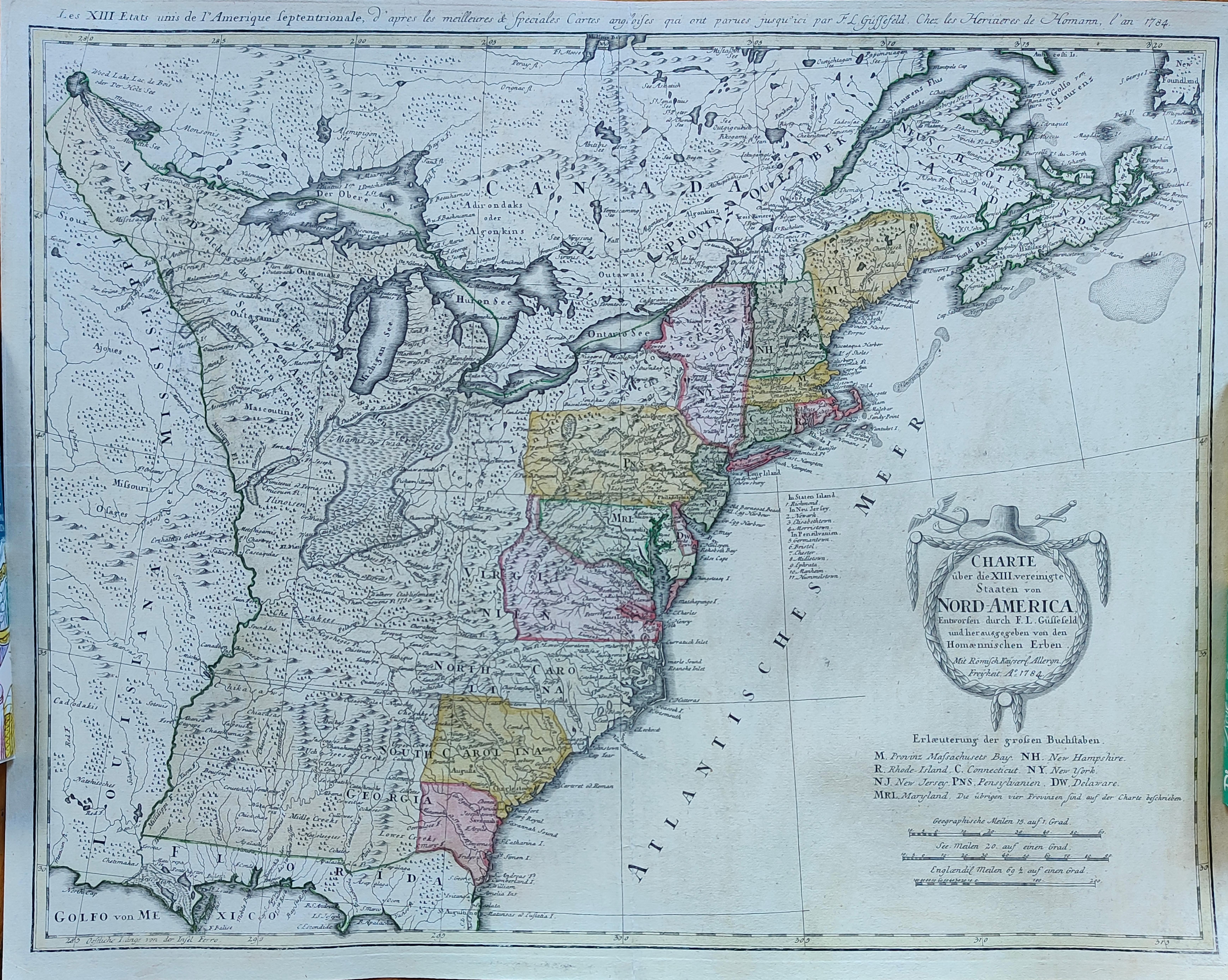
Map title
Charte uber die XIII Vereinigte Staaten von Nord-America
Author
Homann
Location shown in map
USA
Edition date
1784
Edition place
Nuremberg
Editor
Atlas
Price
1300 Euro
State
[mint/EXCELLENT/very good/good/fair/mediocre/poor]
Color
Old colors
Verso
Blank
Size
Plate: cm (58 x 45) inches (22.83 x 17.72) Paper: cm (60 x 49) inches (23.62 x 19.29)
Technique
Copper engraving
Note
United States of America shortly after the revolution
Reference
Wiki
Here for more info
In stock
Available
Info
info@thetreasuremaps.com
Code
#1288
×
![]()
Map title
Carte De La Louisiane Et De La Floride
Author
Bonne
Location shown in map
--
Edition date
1787
Edition place
Paris
Editor
--
Atlas
Atlas Encyclopedique
Price
Please ask: info@thetreasuremaps.com
State
[mint/excellent/very good/GOOD/fair/mediocre/poor]
Color
Modern outlined
Verso
Blank
Size
Plate: cm (31.8 x 21) inches (12.52 x 8.27) Paper: cm (34.3 x 22.9) inches (13.5 x 9.02)
Technique
Copper engraving
Note
In the southeast is Florida and the eastern Atlantic coast reaching as far north as Charleston, South Carolina. In the northeast is part of Virginia. In the northwest corner is the Missouri river with several tributaries, including the Osage. The western part of the map is dominated by the Mississsippi river and it tributaries. The inset in the lower left shows the area of Jefferson City, Missouri where the Osage and Grand rivers flow into the Missouri.
Reference
--
Wiki
Here for more info
In stock
Sold
Info
info@thetreasuremaps.com
Code
#0394
×
![]()
Map title
Carte De La Partie Sud, Des Etats Unis de L' Amerique Septentrionale
Author
Bonne
Location shown in map
East United States
Edition date
1787
Edition place
Paris
Editor
--
Atlas
Atlas Encyclopedique
Price
175 Euro
State
[mint/EXCELLENT/very good/good/fair/mediocre/poor]
Color
Old colors
Verso
Blank
Size
Plate: cm (31 x 21) inches (12.2 x 8.27) Paper: cm (36 x 25) inches (14.17 x 9.84)
Technique
Copper engraving
Note
No particular notes for this maps
Reference
--
Wiki
Here for more info
In stock
Available
Info
info@thetreasuremaps.com
Code
#0724
×
![]()
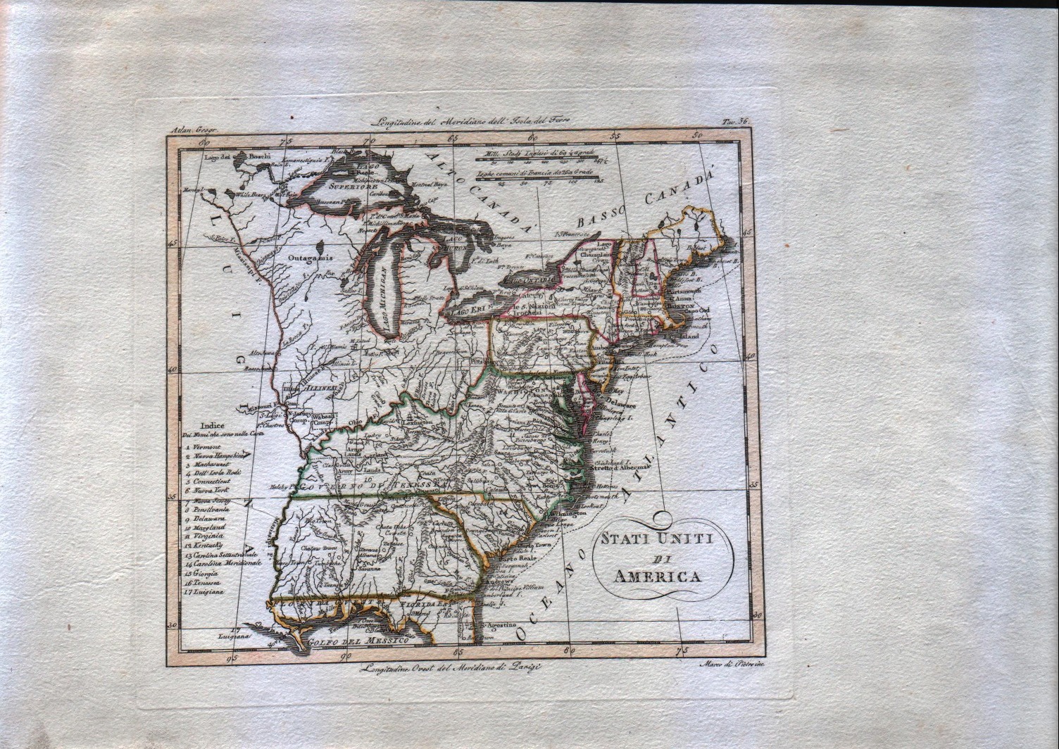
Map title
Stati uniti di America
Author
Unknown
Location shown in map
--
Edition date
1795
Edition place
Venice
Editor
--
Atlas
Compendio di geografia di Guthrie.
Price
125 Euro
State
[mint/EXCELLENT/very good/good/fair/mediocre/poor]
Color
Old outlined
Verso
Blank
Size
Plate: cm (20.3 x 17.8) inches (7.99 x 7.01) Paper: cm (20.3 x 17.8) inches (7.99 x 7.01)
Technique
Copper engraving
Note
This map shows the United States before the aquisition of Florida.
Reference
--
Wiki
Here for more info
In stock
Available
Info
info@thetreasuremaps.com
Code
#0083
×
![]()
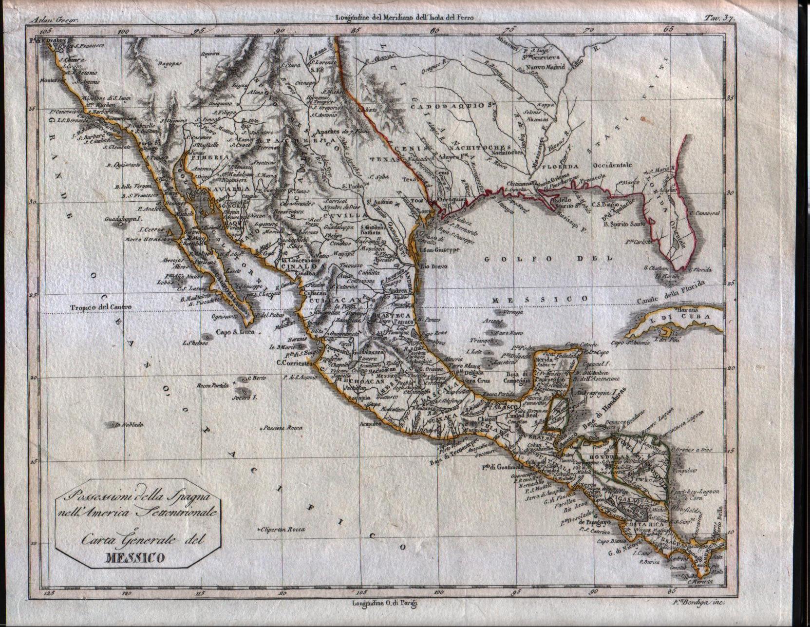
Map title
Possessioni della Spagna nell'america Settentrionale e Carta Generale del Messico
Author
Unknown
Location shown in map
South USA and Mexico
Edition date
1807
Edition place
Milan
Editor
--
Atlas
Barbiellini Atlante delle geografica antica e moderna
Price
125 Euro
State
[mint/EXCELLENT/very good/good/fair/mediocre/poor]
Color
Old outlined
Verso
Blank
Size
Plate: cm (24.8 x 19.7) inches (9.76 x 7.76) Paper: cm (27.9 x 22.9) inches (10.98 x 9.02)
Technique
Copper engraving
Note
Map of the Texas, Mexico, Upper California, Louisiana Territory and Florida. The cartography is certainly pre-1810, naming East and West Florida, showing a pre-Louisiana Purchase Louisiana and very early placenames in the Southwest, most notably Pimeria, Bagiopas, and Quivira, names which would disappear from the map within a few years. Another noteworthy feature is the listing of the Missions in Upper California, which do not generally appear in atlas maps of the period. Nice detail in Texas, including the appearance of the actual name Texas, another unusual early feature. A number of forts and Indian Tribes located. An interesting early map of the region.
Reference
--
Wiki
Here for more info
In stock
Available
Info
info@thetreasuremaps.com
Code
#0084
×
![]()
Map title
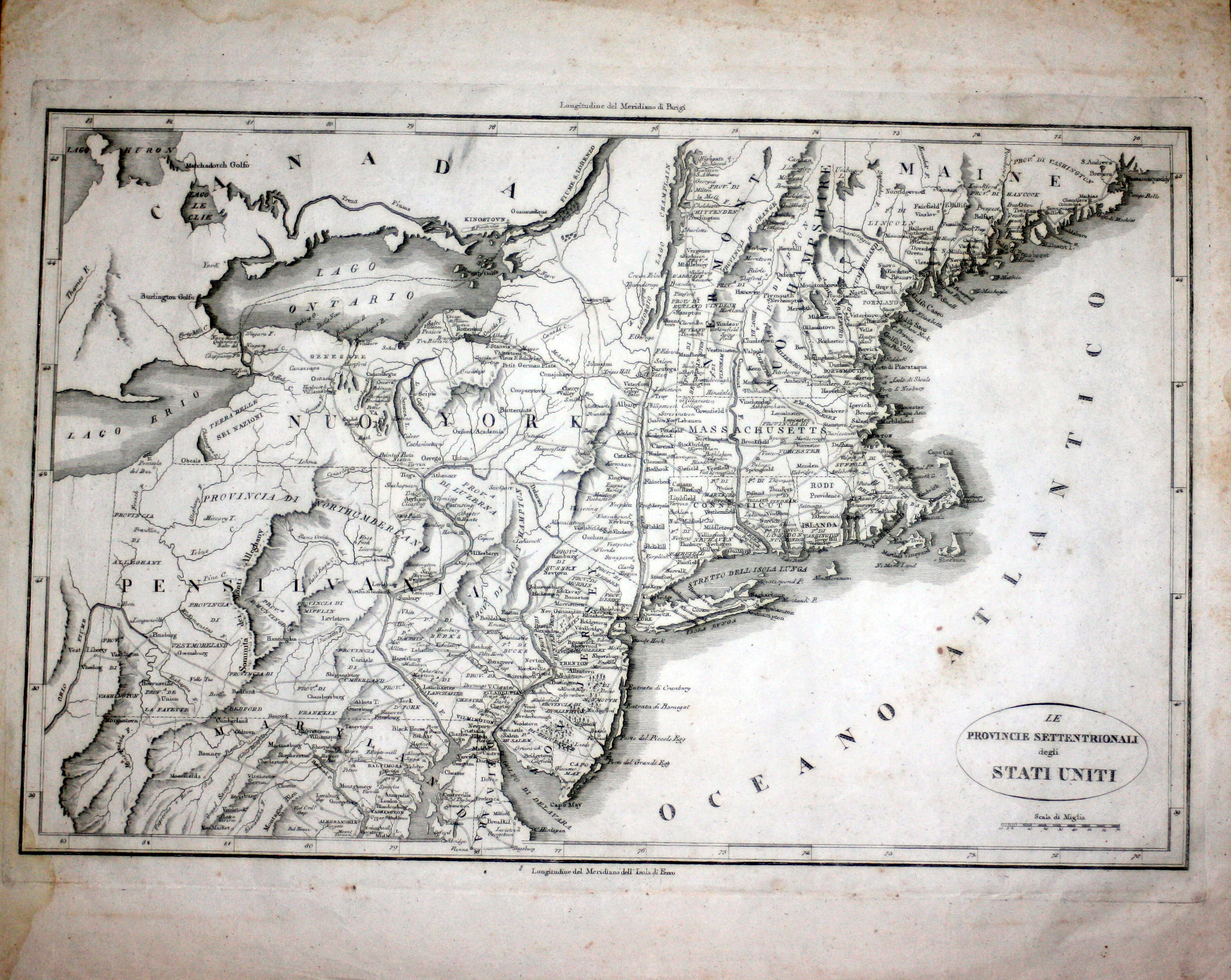
Le provincie settentrionali degli Stati Uniti
Author
Botta
Location shown in map
North East
Edition date
1809
Edition place
Firenze
Editor
Marchini
Atlas
Storia Della Guerra Dell' Independenza Degli Stati Uniti d'America
Price
150 Euro
State
[mint/EXCELLENT/very good/good/fair/mediocre/poor]
Color
Black/white
Verso
White
Size
Plate: cm (48.3 x 31.8) inches (19.02 x 12.52) Paper: cm (50.8 x 41.9) inches (20 x 16.5)
Technique
Copper engraving
Note
No particular notes for this maps.
Reference
--
Wiki
Here for more info
In stock
Available
Info
info@thetreasuremaps.com
Code
#0539
×
![]()
Map title
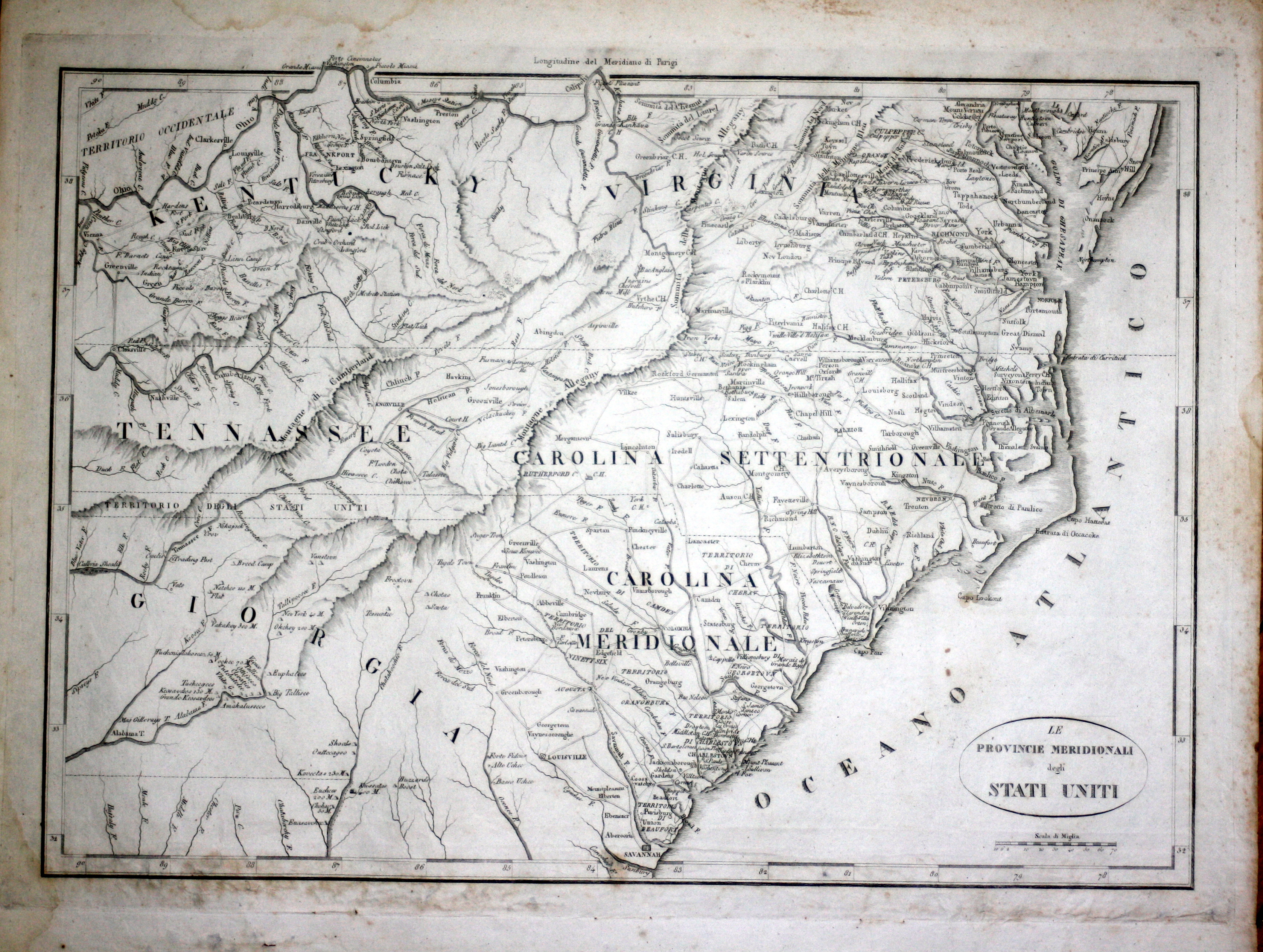
Le provincie meridionali degli Stati Uniti
Author
Botta
Location shown in map
South East coast
Edition date
1809
Edition place
Firenze
Editor
Marchini
Atlas
Storia Della Guerra Dell' Independenza Degli Stati Uniti d'America
Price
150 Euro
State
[mint/EXCELLENT/very good/good/fair/mediocre/poor]
Color
Black/white
Verso
White
Size
Plate: cm (48.3 x 31.8) inches (19.02 x 12.52) Paper: cm (50.8 x 41.9) inches (20 x 16.5)
Technique
Copper engraving
Note
No particular notes for this maps.
Reference
--
Wiki
Here for more info
In stock
Available
Info
info@thetreasuremaps.com
Code
#0540
×
![]()
Map title
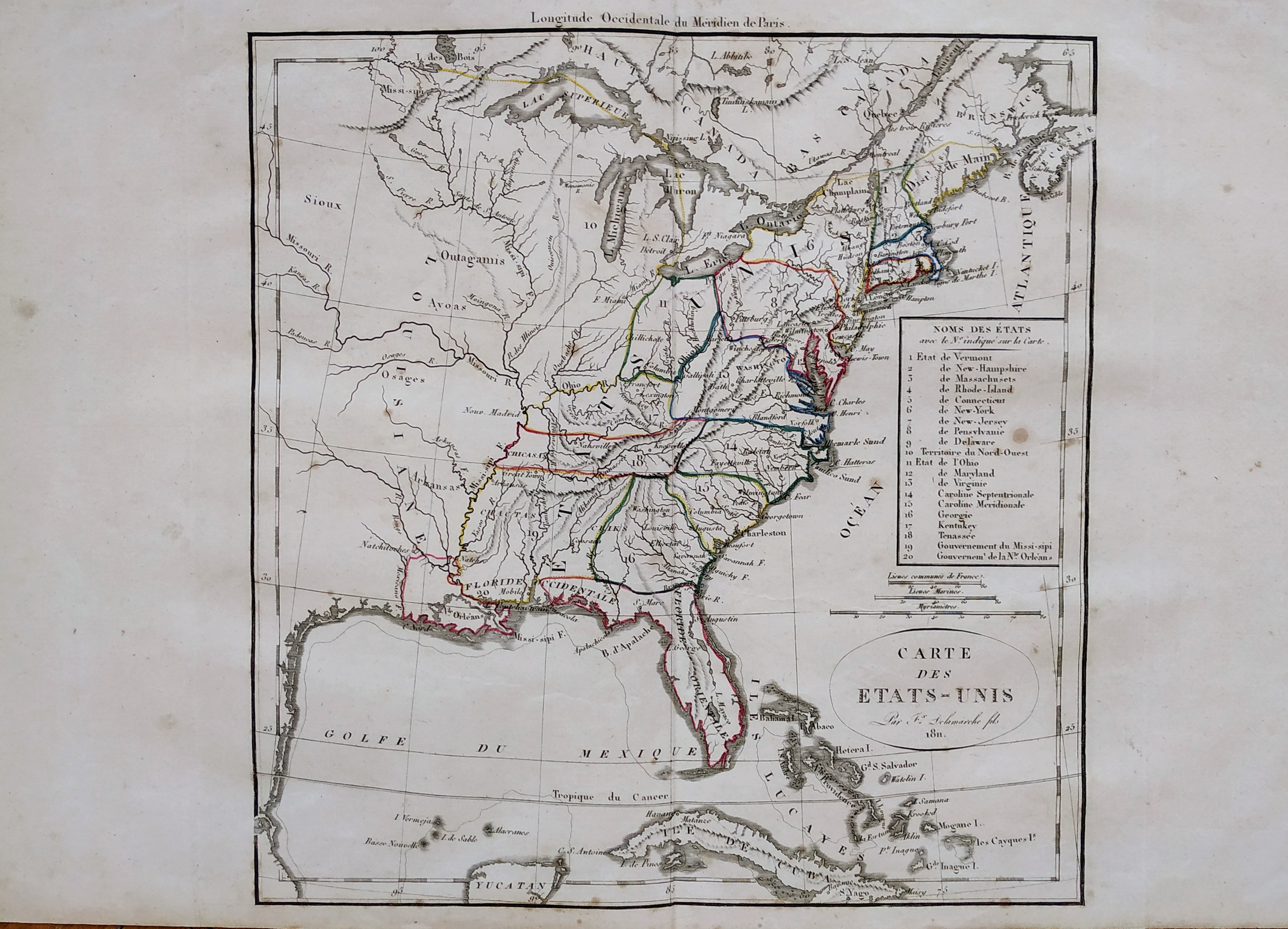
Carte des Etats-Unis
Author
Delamarche
Location shown in map
USA
Edition date
1811
Edition place
Paris
Editor
--
Atlas
Atlas Portatif de Vaugondy
Price
125 Euro
State
[mint/excellent/VERY GOOD/good/fair/mediocre/poor]
Color
Old outlined
Verso
Blank
Size
Plate: cm (27 x 29) inches (10.63 x 11.42) Paper: cm (48 x 31) inches (18.9 x 12.2)
Technique
Copper engraving
Note
Reference
--
Wiki
Here for more info
In stock
Available
Info
info@thetreasuremaps.com
Code
#0749
×
![]()
Map title
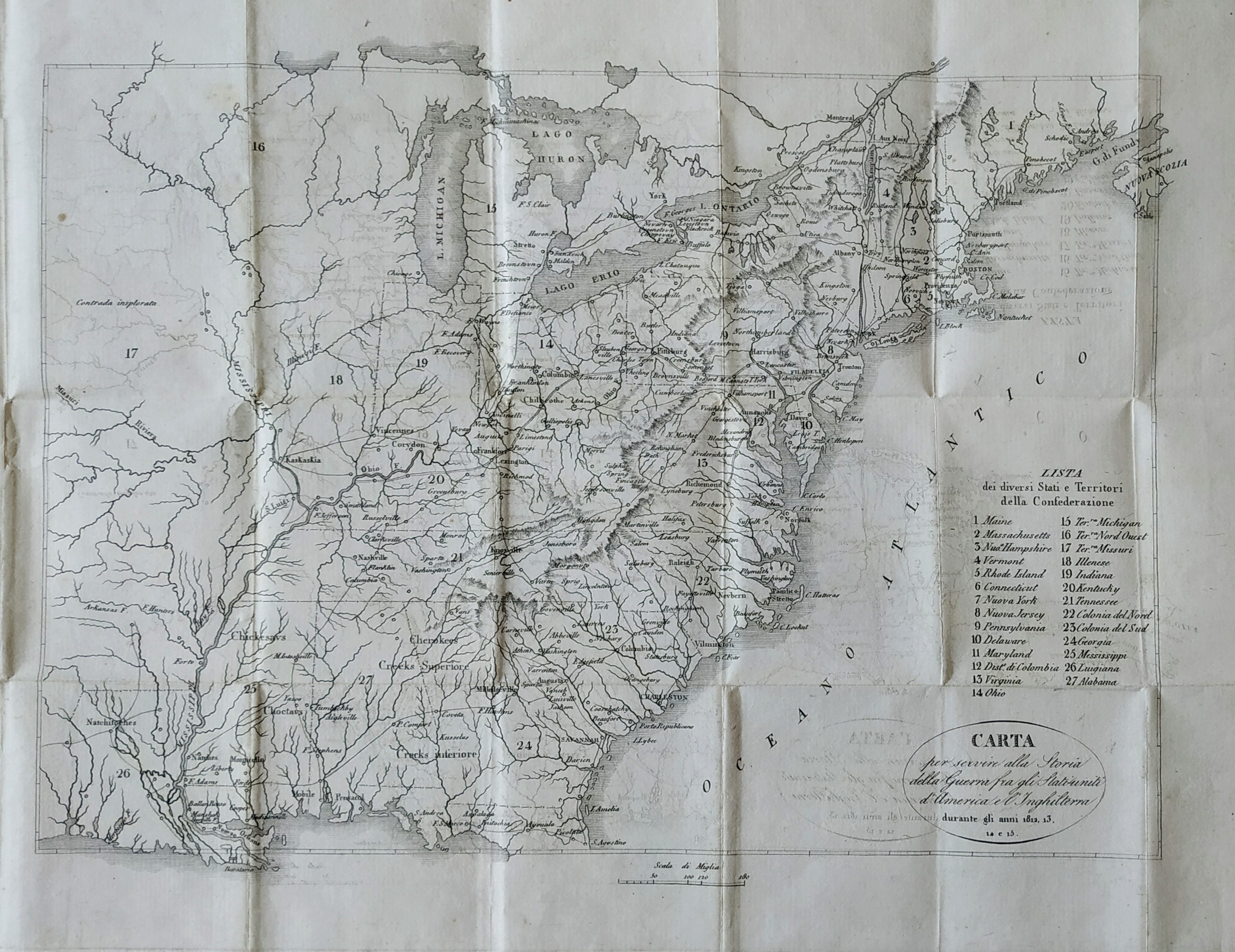
Carta per servire alla storia della guerra fra gli Statiuniti d'America e l'Inghilterra
Author
Brackenrige
Location shown in map
USA west coast
Edition date
1826
Edition place
Firenze
Editor
Bercherini
Atlas
History of the late War, between the United States and Great Britain
Price
100 Euro
State
[mint/EXCELLENT/very good/good/fair/mediocre/poor]
Color
Black/white
Verso
Blank
Size
Plate: cm (38.1 x 27.9) inches (15 x 10.98) Paper: cm (48.3 x 30.5) inches (19.02 x 12.01)
Technique
Copper engraving
Note
No particular notes for this maps.
Reference
--
Wiki
Here for more info
In stock
Available
Info
info@thetreasuremaps.com
Code
#0556
×
![]()
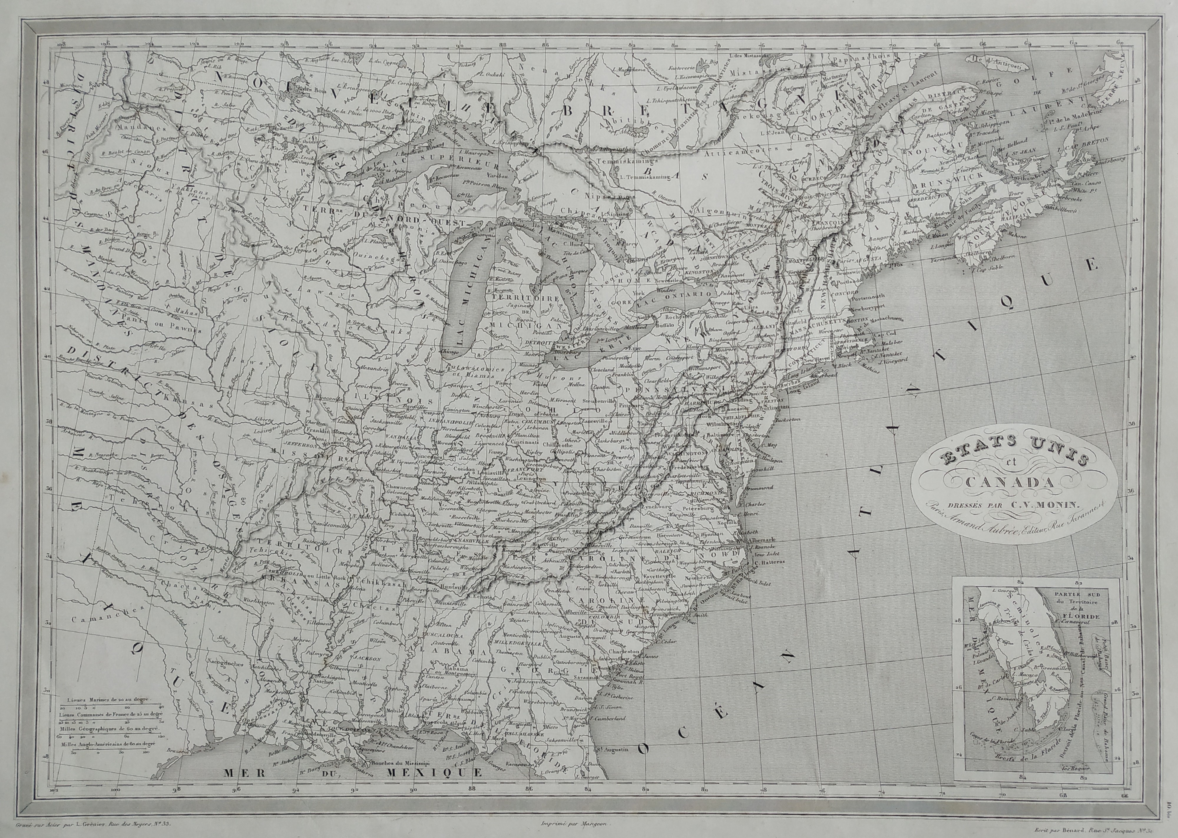
Map title
Etats Unis
Author
Monin
Location shown in map
East coast
Edition date
1837
Edition place
Paris
Editor
Atlas
Price
75 Euro
State
[mint/EXCELLENT/very good/good/fair/mediocre/poor]
Color
Black/white
Verso
Blank
Size
Plate: cm (45 x 32) inches (17.72 x 12.6) Paper: cm (55 x 38) inches (21.65 x 14.96)
Technique
Steel engraving
Note
Reference
Wiki
Here for more info
In stock
Available
Info
info@thetreasuremaps.com
Code
#0793
×
![]()
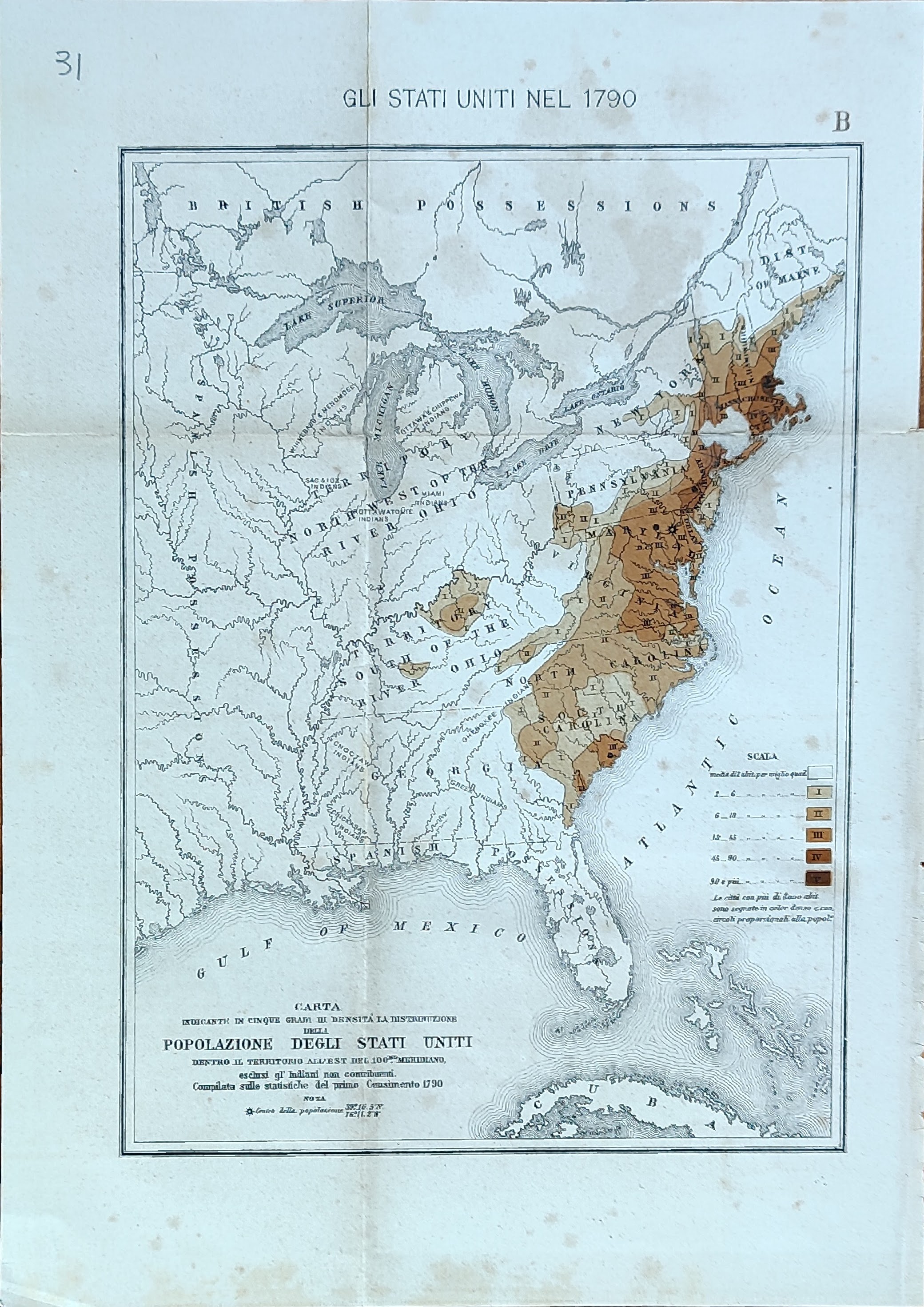
Map title
Carta indicante in cinque gradi di intensita la distribuzione ...
Author
Location shown in map
USA
Edition date
Circa 1880
Edition place
Editor
Atlas
Price
50 Euro
State
[mint/EXCELLENT/very good/good/fair/mediocre/poor]
Color
Old colors
Verso
Blank
Size
Plate: cm (41 x 26) inches (16.14 x 10.24) Paper: cm (46 x 32) inches (18.11 x 12.6)
Technique
Steel engraving
Note
Reference
Wiki
Here for more info
In stock
Available
Info
info@thetreasuremaps.com
Code
#1028
×
![]()
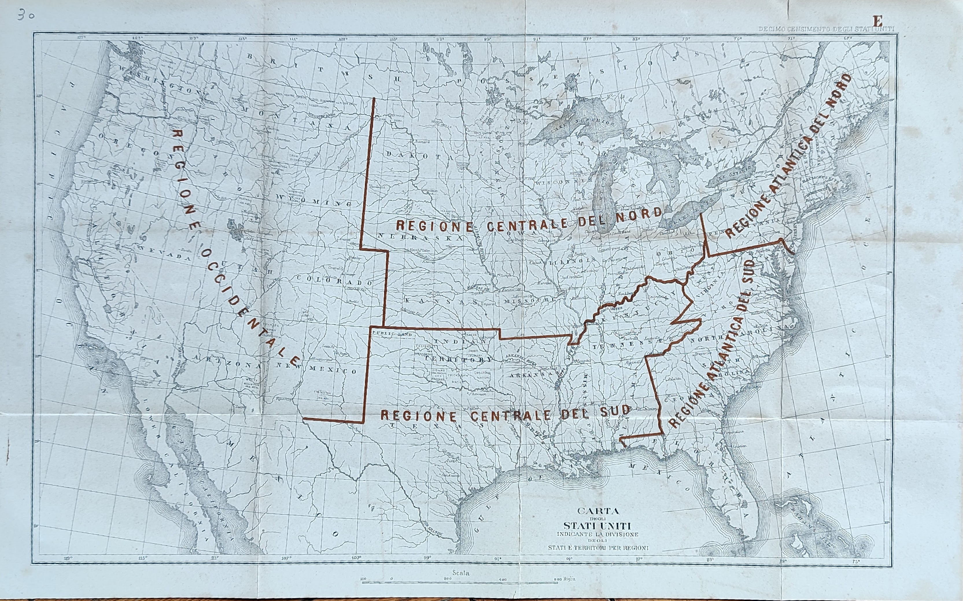
Map title
Carta indicante la divisione ...
Author
Location shown in map
USA
Edition date
Circa 1880
Edition place
Editor
Atlas
Price
50 Euro
State
[mint/EXCELLENT/very good/good/fair/mediocre/poor]
Color
Old colors
Verso
Blank
Size
Plate: cm (41 x 26) inches (16.14 x 10.24) Paper: cm (46 x 32) inches (18.11 x 12.6)
Technique
Steel engraving
Note
Reference
Wiki
Here for more info
In stock
Available
Info
info@thetreasuremaps.com
Code
#1033
×
![]()
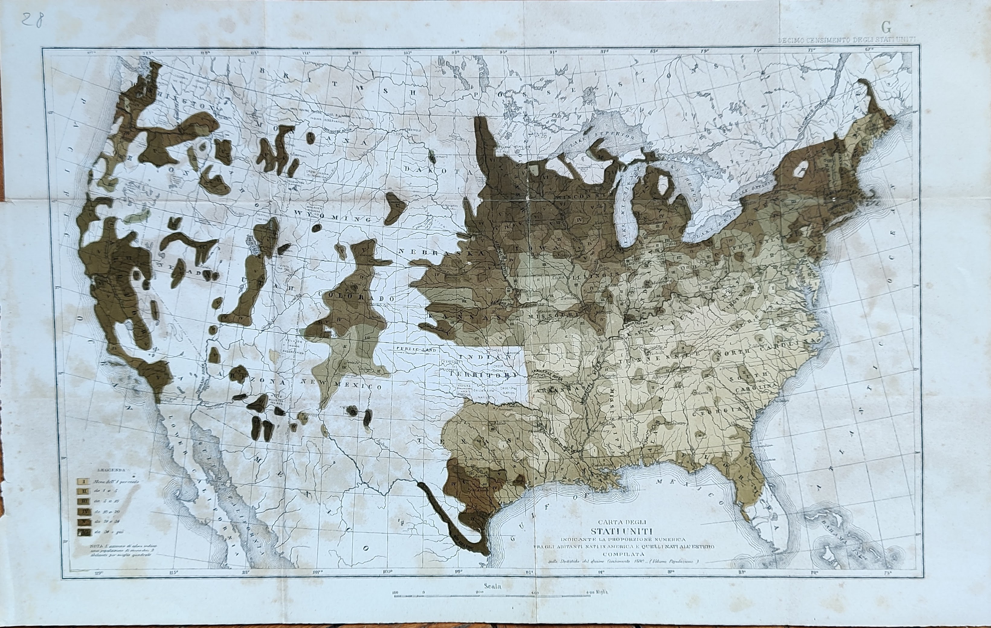
Map title
Carta indicante la proporzione numerica ...
Author
Location shown in map
USA
Edition date
Circa 1880
Edition place
Editor
Atlas
Price
50 Euro
State
[mint/EXCELLENT/very good/good/fair/mediocre/poor]
Color
Old colors
Verso
Blank
Size
Plate: cm (41 x 26) inches (16.14 x 10.24) Paper: cm (46 x 32) inches (18.11 x 12.6)
Technique
Steel engraving
Note
Reference
Wiki
Here for more info
In stock
Available
Info
info@thetreasuremaps.com
Code
#1032
×
![]()
Map title
Carta indicante il percorso delle cinque ...
Author
Location shown in map
USA
Edition date
Circa 1880
Edition place
Editor
Atlas
Price
50 Euro
State
[mint/EXCELLENT/very good/good/fair/mediocre/poor]
Color
Old colors
Verso
Blank
Size
Plate: cm (41 x 26) inches (16.14 x 10.24) Paper: cm (46 x 32) inches (18.11 x 12.6)
Technique
Steel engraving
Note
Reference
Wiki
Here for more info
In stock
Available
Info
info@thetreasuremaps.com
Code
#1031
×
![]()
Map title
Carta indicante in cinque gradi di densita ...
Author
Location shown in map
USA
Edition date
Circa 1880
Edition place
Editor
Atlas
Price
50 Euro
State
[mint/EXCELLENT/very good/good/fair/mediocre/poor]
Color
Old colors
Verso
Blank
Size
Plate: cm (17 x 24) inches (6.69 x 9.45) Paper: cm (22 x 30) inches (8.66 x 11.81)
Technique
Steel engraving
Note
Reference
Wiki
Here for more info
In stock
Available
Info
info@thetreasuremaps.com
Code
#1030
×
![]()
Map title
Carta indicante le concessioni di terreni ...
Author
Location shown in map
USA
Edition date
Circa 1880
Edition place
Editor
Atlas
Price
50 Euro
State
[mint/EXCELLENT/very good/good/fair/mediocre/poor]
Color
Old colors
Verso
Blank
Size
Plate: cm (41 x 26) inches (16.14 x 10.24) Paper: cm (46 x 32) inches (18.11 x 12.6)
Technique
Steel engraving
Note
Reference
Wiki
Here for more info
In stock
Available
Info
info@thetreasuremaps.com
Code
#1029
×
![]()
Map title
Pianta della Nuova Orleans
Author
Location shown in map
New Orleans
Edition date
Circa 1880
Edition place
Editor
--
Atlas
Price
75 Euro
State
[mint/EXCELLENT/very good/good/fair/mediocre/poor]
Color
Black/white
Verso
Blank
Size
Plate: cm (27 x 22) inches (10.63 x 8.66) Paper: cm (31 x 26) inches (12.2 x 10.24)
Technique
Steel engraving
Note
Reference
--
Wiki
Here for more info
In stock
Available
Info
info@thetreasuremaps.com
Code
#0947
×
![]()
Map title
Pianta di San Francisco
Author
Location shown in map
San Francisco
Edition date
Circa 1880
Edition place
Editor
--
Atlas
Price
Please ask: info@thetreasuremaps.com
State
[mint/EXCELLENT/very good/good/fair/mediocre/poor]
Color
Black/white
Verso
Blank
Size
Plate: cm (26 x 27) inches (10.24 x 10.63) Paper: cm (30 x 31) inches (11.81 x 12.2)
Technique
Steel engraving
Note
Reference
--
Wiki
Here for more info
In stock
Available
Info
info@thetreasuremaps.com
Code
#0946
×
![]()
Map title
Pianta di Cincinnati
Author
Location shown in map
Cincinnati
Edition date
Circa 1880
Edition place
Editor
--
Atlas
Price
Please ask: info@thetreasuremaps.com
State
[mint/EXCELLENT/very good/good/fair/mediocre/poor]
Color
Black/white
Verso
Blank
Size
Plate: cm (27 x 21) inches (10.63 x 8.27) Paper: cm (32 x 26) inches (12.6 x 10.24)
Technique
Steel engraving
Note
Reference
--
Wiki
Here for more info
In stock
Available
Info
info@thetreasuremaps.com
Code
#0945
×
![]()
Map title
Pianta di Chicago
Author
Location shown in map
Chicago
Edition date
Circa 1880
Edition place
Editor
--
Atlas
Price
Please ask: info@thetreasuremaps.com
State
[mint/EXCELLENT/very good/good/fair/mediocre/poor]
Color
Black/white
Verso
Blank
Size
Plate: cm (34 x 25) inches (13.39 x 9.84) Paper: cm (39 x 30) inches (15.35 x 11.81)
Technique
Steel engraving
Note
Reference
--
Wiki
Here for more info
In stock
Available
Info
info@thetreasuremaps.com
Code
#0944
×
![]()
Map title
Pianta di NuovaYork
Author
Location shown in map
NewYork
Edition date
Circa 1880
Edition place
Editor
--
Atlas
Price
100 Euro
State
[mint/EXCELLENT/very good/good/fair/mediocre/poor]
Color
Black/white
Verso
Blank
Size
Plate: cm (22 x 35) inches (8.66 x 13.78) Paper: cm (25 x 41) inches (9.84 x 16.14)
Technique
Steel engraving
Note
Reference
--
Wiki
Here for more info
In stock
Available
Info
info@thetreasuremaps.com
Code
#0943
×
![]()
Map title
The New York central
Author
Location shown in map
New York
Edition date
1893
Edition place
New York
Editor
Atlas
Price
250 Euro
State
[mint/EXCELLENT/very good/good/fair/mediocre/poor]
Color
Old colors
Verso
English text
Size
Plate: cm (110 x 41) inches (43.31 x 16.14) Paper: cm (110 x 41) inches (43.31 x 16.14)
Technique
Steel engraving
Note
Reference
Wiki
Here for more info
In stock
Available
Info
info@thetreasuremaps.com
Code
#1026
×
![]()
Map title
Hagstorm's map of New York city
Author
Location shown in map
NewYork
Edition date
1948
Edition place
New York
Editor
Hagstorm
Atlas
Price
100 Euro
State
[mint/EXCELLENT/very good/good/fair/mediocre/poor]
Color
Old colors
Verso
Size
Plate: cm (0 x 0) inches (0 x 0) Paper: cm (0 x 0) inches (0 x 0)
Technique
Steel engraving
Note
Turist map.
Reference
Wiki
Here for more info
In stock
Available
Info
info@thetreasuremaps.com
Code
#1109
×
![]()
Map title
Vereinigten staaten von Amerika
Author
Location shown in map
USA
Edition date
Circa 1950
Edition place
NewYork
Editor
Atlas
Price
100 Euro
State
[mint/EXCELLENT/very good/good/fair/mediocre/poor]
Color
Old colors
Verso
Blank
Size
Plate: cm (85 x 61) inches (33.46 x 24.02) Paper: cm (85 x 61) inches (33.46 x 24.02)
Technique
Steel engraving
Note
Pictorial map
Reference
Wiki
Here for more info
In stock
Available
Info
info@thetreasuremaps.com
Code
#1133
×
![]()
Map title
Boston le sue vicinanze
Author
Unnown
Location shown in map
City Boston
Edition date
Unknown
Edition place
--
Editor
--
Atlas
--
Price
125 Euro
State
[MINT/excellent/very good/good/fair/mediocre/poor]
Color
Black/white
Verso
Blank
Size
Plate: cm (11.4 x 17.8) inches (4.49 x 7.01) Paper: cm (14 x 22.9) inches (5.51 x 9.02)
Technique
Copper engraving
Note
No particular notes for this maps.
Reference
--
Wiki
Here for more info
In stock
Available
Info
info@thetreasuremaps.com
Code
#0557
×
![]()