West Indies
Map title
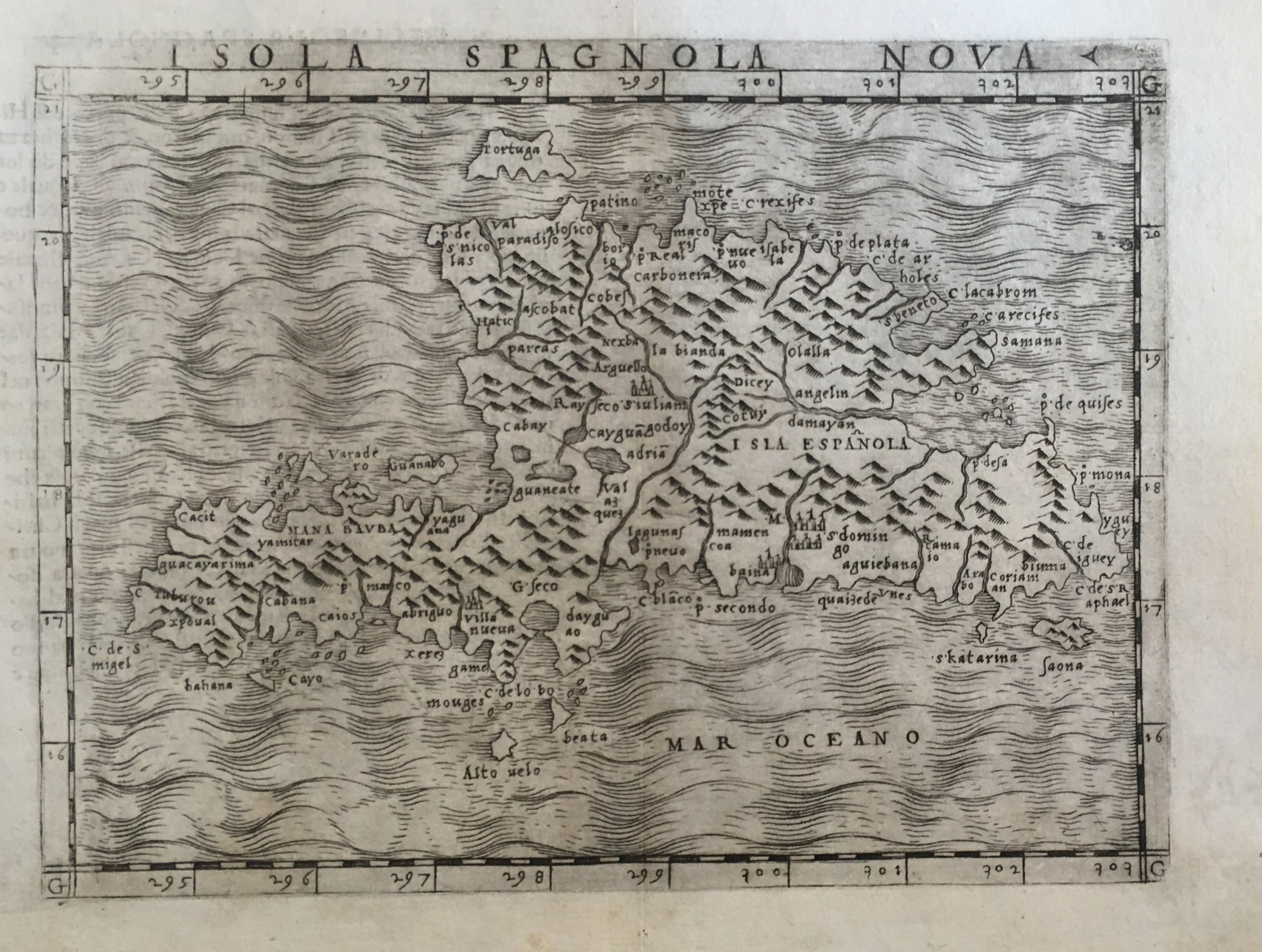
Isola Spagnola nova
Mapmakers
Gastaldi
LocationLocation shown in map
Haiti island
Edition date
1548
Edition place
Venice
Editor
Nicolo Bascarini
Atlas
Geographia
Price
300 Euro
State
[mint/EXCELLENT/very good/good/fair/mediocre/poor] professionally restored
Color
Black/white
Verso
Italian text pag.58
Size
Plate: cm (17.8 x 12.7) inches (7.01 x 5) Paper: cm (20.3 x 16.5) inches (7.99 x 6.5)
Technique
Copper engraving
Note
No particular notes for this maps
Reference
--
Wiki
Here for more info
In stock
Available
Info
info@thetreasuremaps.com
Code
#0637
Isola Spagnola nova
Mapmakers
Gastaldi
Haiti island
Edition date
1548
Edition place
Venice
Editor
Nicolo Bascarini
Atlas
Geographia
Price
300 Euro
State
[mint/EXCELLENT/very good/good/fair/mediocre/poor] professionally restored
Color
Black/white
Verso
Italian text pag.58
Size
Plate: cm (17.8 x 12.7) inches (7.01 x 5) Paper: cm (20.3 x 16.5) inches (7.99 x 6.5)
Technique
Copper engraving
Note
No particular notes for this maps
Reference
--
Wiki
Here for more info
In stock
Available
Info
info@thetreasuremaps.com
Code
#0637
×
![]()
Map title
Isola Cuba Nova
Mapmakers
Ruscelli
LocationLocation shown in map
Cuba
Edition date
1561
Edition place
Venice
Editor
Vincenzo Valgrisi
Atlas
La Geographia di Claudio Tolomeo
Price
300 Euro
State
[mint/excellent/very good/GOOD/fair/mediocre/poor]
Color
Black/white
Verso
Italian text pag.33
Size
Plate: cm (26 x 19) inches (10.24 x 7.48) Paper: cm (27.9 x 20.3) inches (10.98 x 7.99)
Technique
Copper engraving
Note
--
Reference
--
Wiki
Here for more info
In stock
Available
Info
info@thetreasuremaps.com
Code
#0534
Isola Cuba Nova
Mapmakers
Ruscelli
Cuba
Edition date
1561
Edition place
Venice
Editor
Vincenzo Valgrisi
Atlas
La Geographia di Claudio Tolomeo
Price
300 Euro
State
[mint/excellent/very good/GOOD/fair/mediocre/poor]
Color
Black/white
Verso
Italian text pag.33
Size
Plate: cm (26 x 19) inches (10.24 x 7.48) Paper: cm (27.9 x 20.3) inches (10.98 x 7.99)
Technique
Copper engraving
Note
--
Reference
--
Wiki
Here for more info
In stock
Available
Info
info@thetreasuremaps.com
Code
#0534
×
![]()
Map title
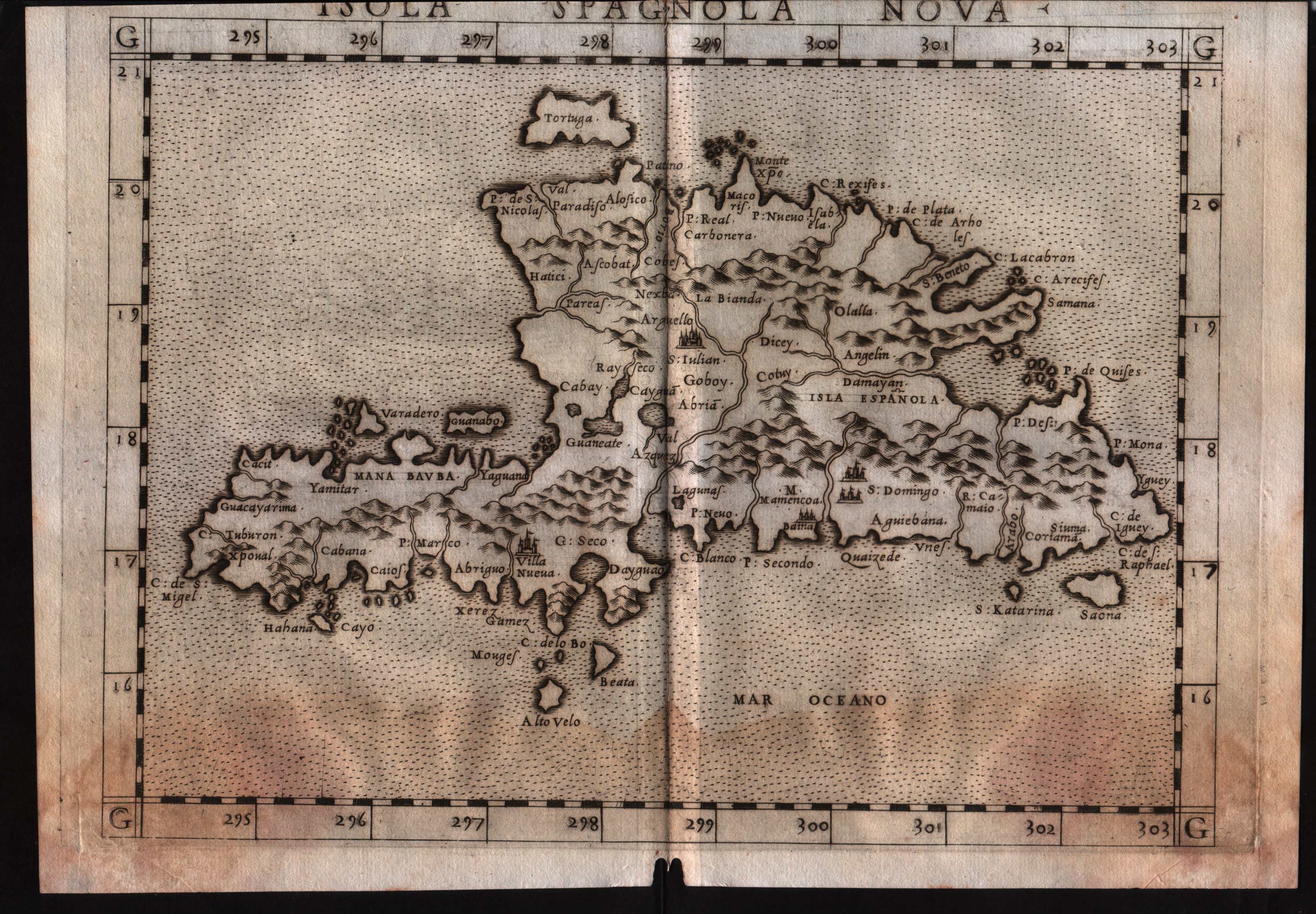
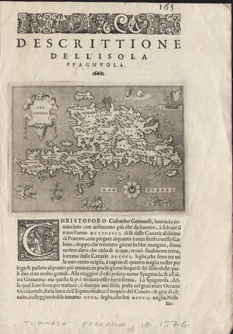
Isola Spagnola Nova
Mapmakers
Ruscelli
LocationLocation shown in map
Haiti
Edition date
1561
Edition place
Venice
Editor
Vincenzo Valgrisi
Atlas
La Geographia di Claudio Tolomeo
Price
300 Euro
State
[mint/excellent/VERY GOOD/good/fair/mediocre/poor]
Color
Black/white
Verso
Italian text pag.34
Size
Plate: cm (26 x 19) inches (10.24 x 7.48) Paper: cm (27.9 x 20.3) inches (10.98 x 7.99)
Technique
Copper engraving
Note
No particular notes for this maps.
Reference
--
Wiki
Here for more info
In stock
Available
Info
info@thetreasuremaps.com
Code
#0536
Isola Spagnola Nova
Mapmakers
Ruscelli
Haiti
Edition date
1561
Edition place
Venice
Editor
Vincenzo Valgrisi
Atlas
La Geographia di Claudio Tolomeo
Price
300 Euro
State
[mint/excellent/VERY GOOD/good/fair/mediocre/poor]
Color
Black/white
Verso
Italian text pag.34
Size
Plate: cm (26 x 19) inches (10.24 x 7.48) Paper: cm (27.9 x 20.3) inches (10.98 x 7.99)
Technique
Copper engraving
Note
No particular notes for this maps.
Reference
--
Wiki
Here for more info
In stock
Available
Info
info@thetreasuremaps.com
Code
#0536
×
![]()
Map title
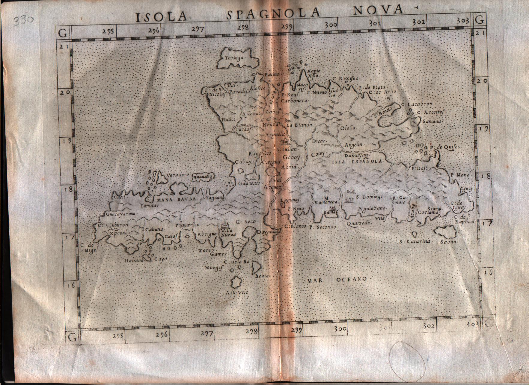
Isola Spagnola Nova
Mapmakers
Ruscelli
LocationLocation shown in map
Haiti
Edition date
1564
Edition place
Venice
Editor
Girolamo Ziletti
Atlas
La Geographia di Claudio Tolomeo
Price
300 Euro
State
[mint/excellent/VERY GOOD/good/fair/mediocre/poor]
Color
Black/white
Verso
Latin text pag.64
Size
Plate: cm (25.4 x 19) inches (10 x 7.48) Paper: cm (30.5 x 22.9) inches (12.01 x 9.02)
Technique
Copper engraving
Note
--
Reference
--
Wiki
Here for more info
In stock
Available
Info
info@thetreasuremaps.com
Code
#0340
Isola Spagnola Nova
Mapmakers
Ruscelli
Haiti
Edition date
1564
Edition place
Venice
Editor
Girolamo Ziletti
Atlas
La Geographia di Claudio Tolomeo
Price
300 Euro
State
[mint/excellent/VERY GOOD/good/fair/mediocre/poor]
Color
Black/white
Verso
Latin text pag.64
Size
Plate: cm (25.4 x 19) inches (10 x 7.48) Paper: cm (30.5 x 22.9) inches (12.01 x 9.02)
Technique
Copper engraving
Note
--
Reference
--
Wiki
Here for more info
In stock
Available
Info
info@thetreasuremaps.com
Code
#0340
×
![]()
Map title
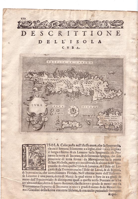
Descrittione dell'isola Cuba
Mapmakers
Porcacchi
LocationLocation shown in map
Cuba
Edition date
1576
Edition place
Venice
Editor
--
Atlas
L'Isole piu famose del mondo -- S. Galignani and G. Porro
Price
Please ask: info@thetreasuremaps.com
State
[MINT/excellent/very good/good/fair/mediocre/poor]
Color
Black/white
Verso
Italian text pag.171
Size
Plate: cm (15.2 x 11.4) inches (5.98 x 4.49) Paper: cm (19 x 27.9) inches (7.48 x 10.98)
Technique
Copper engraving
Note
No particular notes for this maps
Reference
Genoa pubblic library "Civica Berio"
Wiki
Here for more info
In stock
Available
Info
info@thetreasuremaps.com
Code
#0341
Descrittione dell'isola Cuba
Mapmakers
Porcacchi
Cuba
Edition date
1576
Edition place
Venice
Editor
--
Atlas
L'Isole piu famose del mondo -- S. Galignani and G. Porro
Price
Please ask: info@thetreasuremaps.com
State
[MINT/excellent/very good/good/fair/mediocre/poor]
Color
Black/white
Verso
Italian text pag.171
Size
Plate: cm (15.2 x 11.4) inches (5.98 x 4.49) Paper: cm (19 x 27.9) inches (7.48 x 10.98)
Technique
Copper engraving
Note
No particular notes for this maps
Reference
Genoa pubblic library "Civica Berio"
Wiki
Here for more info
In stock
Available
Info
info@thetreasuremaps.com
Code
#0341
×
![]()
Map title
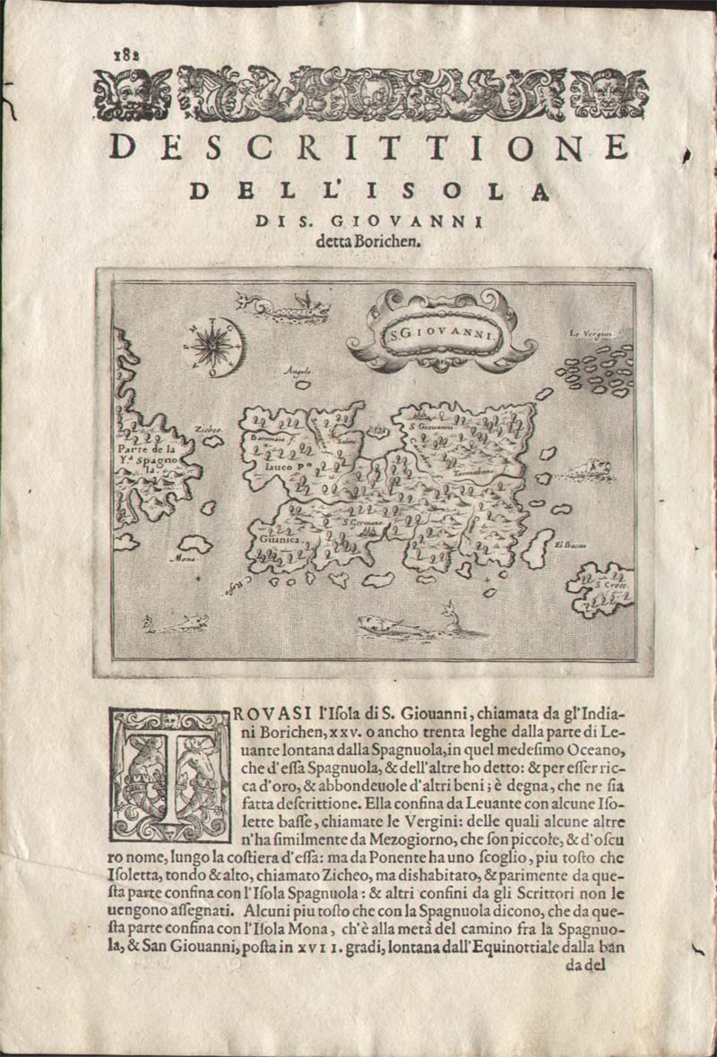
Descrittione dell'isola di S.Giovanni
Mapmakers
Porcacchi
LocationLocation shown in map
Puerto Rico
Edition date
1576
Edition place
Venice
Editor
--
Atlas
L'Isole piu famose del mondo -- S. Galignani and G. Porro
Price
Please ask: info@thetreasuremaps.com
State
[MINT/excellent/very good/good/fair/mediocre/poor]
Color
Black/white
Verso
Italian text pag.182
Size
Plate: cm (15.2 x 11.4) inches (5.98 x 4.49) Paper: cm (19 x 27.9) inches (7.48 x 10.98)
Technique
Copper engraving
Note
No particular notes for this maps
Reference
Genoa pubblic library "Civica Berio"
Wiki
Here for more info
In stock
Sold
Info
info@thetreasuremaps.com
Code
#0432
Descrittione dell'isola di S.Giovanni
Mapmakers
Porcacchi
Puerto Rico
Edition date
1576
Edition place
Venice
Editor
--
Atlas
L'Isole piu famose del mondo -- S. Galignani and G. Porro
Price
Please ask: info@thetreasuremaps.com
State
[MINT/excellent/very good/good/fair/mediocre/poor]
Color
Black/white
Verso
Italian text pag.182
Size
Plate: cm (15.2 x 11.4) inches (5.98 x 4.49) Paper: cm (19 x 27.9) inches (7.48 x 10.98)
Technique
Copper engraving
Note
No particular notes for this maps
Reference
Genoa pubblic library "Civica Berio"
Wiki
Here for more info
In stock
Sold
Info
info@thetreasuremaps.com
Code
#0432
×
![]()
Map title
Descrittione dell'isola Spagnola
Mapmakers
Porcacchi
LocationLocation shown in map
Haiti
Edition date
1576
Edition place
Venice
Editor
--
Atlas
L'Isole piu famose del mondo -- S. Galignani and G. Porro
Price
Please ask: info@thetreasuremaps.com
State
[MINT/excellent/very good/good/fair/mediocre/poor]
Color
Black/white
Verso
Italian text pag.166
Size
Plate: cm (15.2 x 11.4) inches (5.98 x 4.49) Paper: cm (19 x 27.9) inches (7.48 x 10.98)
Technique
Copper engraving
Note
No particular notes for this maps
Reference
Genoa pubblic library "Civica Berio"
Wiki
Here for more info
In stock
Available
Info
info@thetreasuremaps.com
Code
#0799
Descrittione dell'isola Spagnola
Mapmakers
Porcacchi
Haiti
Edition date
1576
Edition place
Venice
Editor
--
Atlas
L'Isole piu famose del mondo -- S. Galignani and G. Porro
Price
Please ask: info@thetreasuremaps.com
State
[MINT/excellent/very good/good/fair/mediocre/poor]
Color
Black/white
Verso
Italian text pag.166
Size
Plate: cm (15.2 x 11.4) inches (5.98 x 4.49) Paper: cm (19 x 27.9) inches (7.48 x 10.98)
Technique
Copper engraving
Note
No particular notes for this maps
Reference
Genoa pubblic library "Civica Berio"
Wiki
Here for more info
In stock
Available
Info
info@thetreasuremaps.com
Code
#0799
×
![]()
Map title
Descrittione dell'isola Spaguola
Mapmakers
Porcacchi
LocationLocation shown in map
Haiti island
Edition date
1590
Edition place
Venice
Editor
--
Atlas
L'Isole piu famose del mondo -- S. Galignani and G. Porro
Price
200 Euro
State
[MINT/excellent/very good/good/fair/mediocre/poor]
Color
Black/white
Verso
Italian text pag.166
Size
Plate: cm (15.2 x 11.4) inches (5.98 x 4.49) Paper: cm (19 x 29.2) inches (7.48 x 11.5)
Technique
Copper engraving
Note
Decorated with sea monsters and sailing ships.
Reference
--
Wiki
Here for more info
In stock
Available
Info
info@thetreasuremaps.com
Code
#0342
Descrittione dell'isola Spaguola
Mapmakers
Porcacchi
Haiti island
Edition date
1590
Edition place
Venice
Editor
--
Atlas
L'Isole piu famose del mondo -- S. Galignani and G. Porro
Price
200 Euro
State
[MINT/excellent/very good/good/fair/mediocre/poor]
Color
Black/white
Verso
Italian text pag.166
Size
Plate: cm (15.2 x 11.4) inches (5.98 x 4.49) Paper: cm (19 x 29.2) inches (7.48 x 11.5)
Technique
Copper engraving
Note
Decorated with sea monsters and sailing ships.
Reference
--
Wiki
Here for more info
In stock
Available
Info
info@thetreasuremaps.com
Code
#0342
×
![]()
Map title
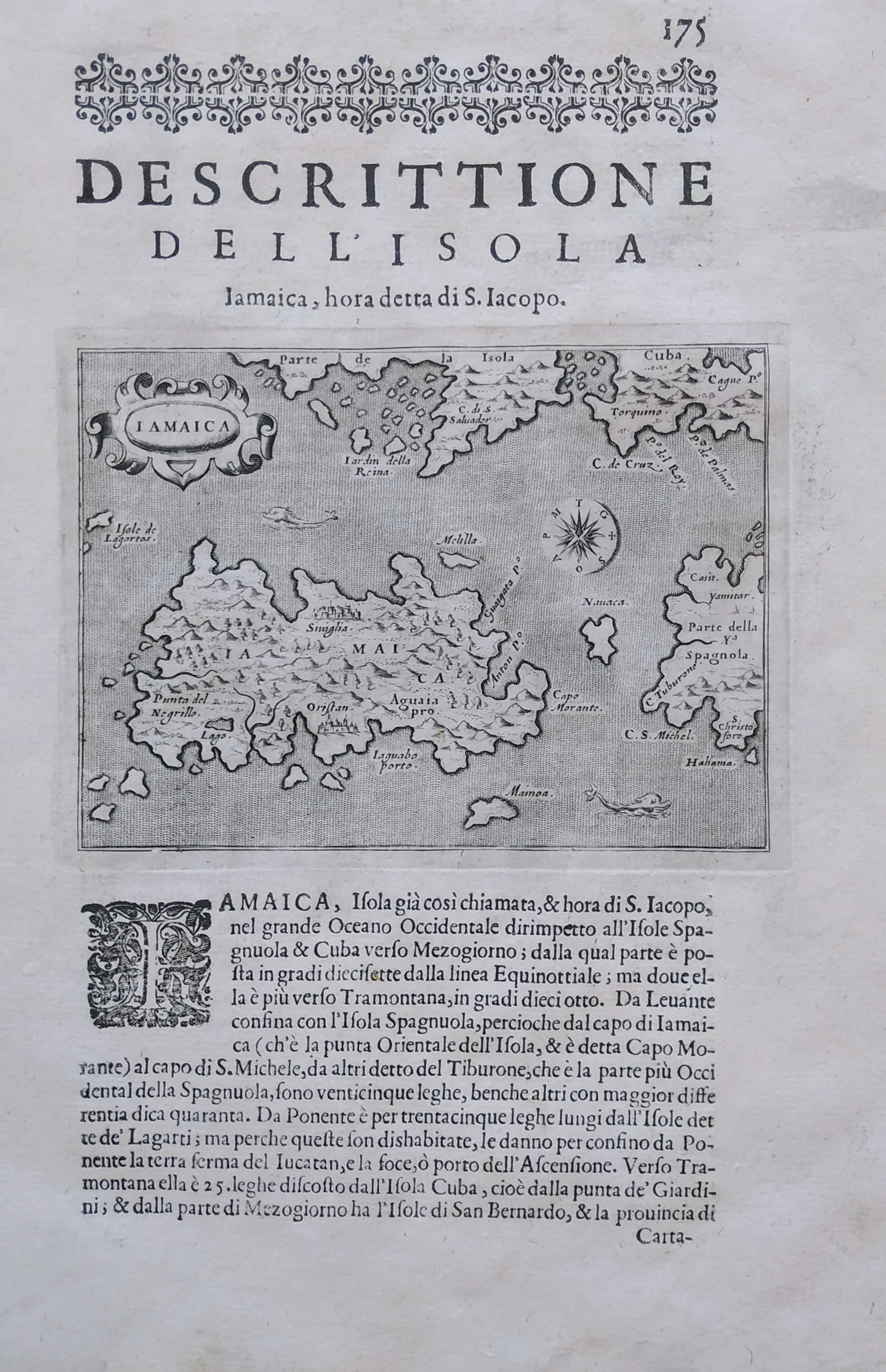
Descrittione dell'isola Iamaica
Mapmakers
Porcacchi
LocationLocation shown in map
Jamaica
Edition date
1590
Edition place
Venice
Editor
--
Atlas
L'Isole piu famose del mondo -- Pietr'Antonio Brigonci
Price
200 Euro
State
[MINT/excellent/very good/good/fair/mediocre/poor]
Color
Black/white
Verso
Italian text pag.176
Size
Plate: cm (14 x 11.4) inches (5.51 x 4.49) Paper: cm (20.3 x 29) inches (7.99 x 11.42)
Technique
Copper engraving
Note
No particular notes for this maps
Reference
--
Wiki
Here for more info
In stock
Available
Info
info@thetreasuremaps.com
Code
#0930
Descrittione dell'isola Iamaica
Mapmakers
Porcacchi
Jamaica
Edition date
1590
Edition place
Venice
Editor
--
Atlas
L'Isole piu famose del mondo -- Pietr'Antonio Brigonci
Price
200 Euro
State
[MINT/excellent/very good/good/fair/mediocre/poor]
Color
Black/white
Verso
Italian text pag.176
Size
Plate: cm (14 x 11.4) inches (5.51 x 4.49) Paper: cm (20.3 x 29) inches (7.99 x 11.42)
Technique
Copper engraving
Note
No particular notes for this maps
Reference
--
Wiki
Here for more info
In stock
Available
Info
info@thetreasuremaps.com
Code
#0930
×
![]()
Map title
Descrittione dell'isola di S.Giovanni
Mapmakers
Porcacchi
LocationLocation shown in map
Puerto Rico
Edition date
1590
Edition place
Venice
Editor
--
Atlas
L'Isole piu famose del mondo -- S. Galignani and G. Porro
Price
400 Euro
State
[MINT/excellent/very good/good/fair/mediocre/poor]
Color
Moden colors
Verso
Italian text pag.182
Size
Plate: cm (15.2 x 11.4) inches (5.98 x 4.49) Paper: cm (19 x 27.9) inches (7.48 x 10.98)
Technique
Copper engraving
Note
Reference
Genoa pubblic library "Civica Berio"
Wiki
Here for more info
In stock
Available
Info
info@thetreasuremaps.com
Code
#0965
Descrittione dell'isola di S.Giovanni
Mapmakers
Porcacchi
Puerto Rico
Edition date
1590
Edition place
Venice
Editor
--
Atlas
L'Isole piu famose del mondo -- S. Galignani and G. Porro
Price
400 Euro
State
[MINT/excellent/very good/good/fair/mediocre/poor]
Color
Moden colors
Verso
Italian text pag.182
Size
Plate: cm (15.2 x 11.4) inches (5.98 x 4.49) Paper: cm (19 x 27.9) inches (7.48 x 10.98)
Technique
Copper engraving
Note
Reference
Genoa pubblic library "Civica Berio"
Wiki
Here for more info
In stock
Available
Info
info@thetreasuremaps.com
Code
#0965
×
![]()
Map title
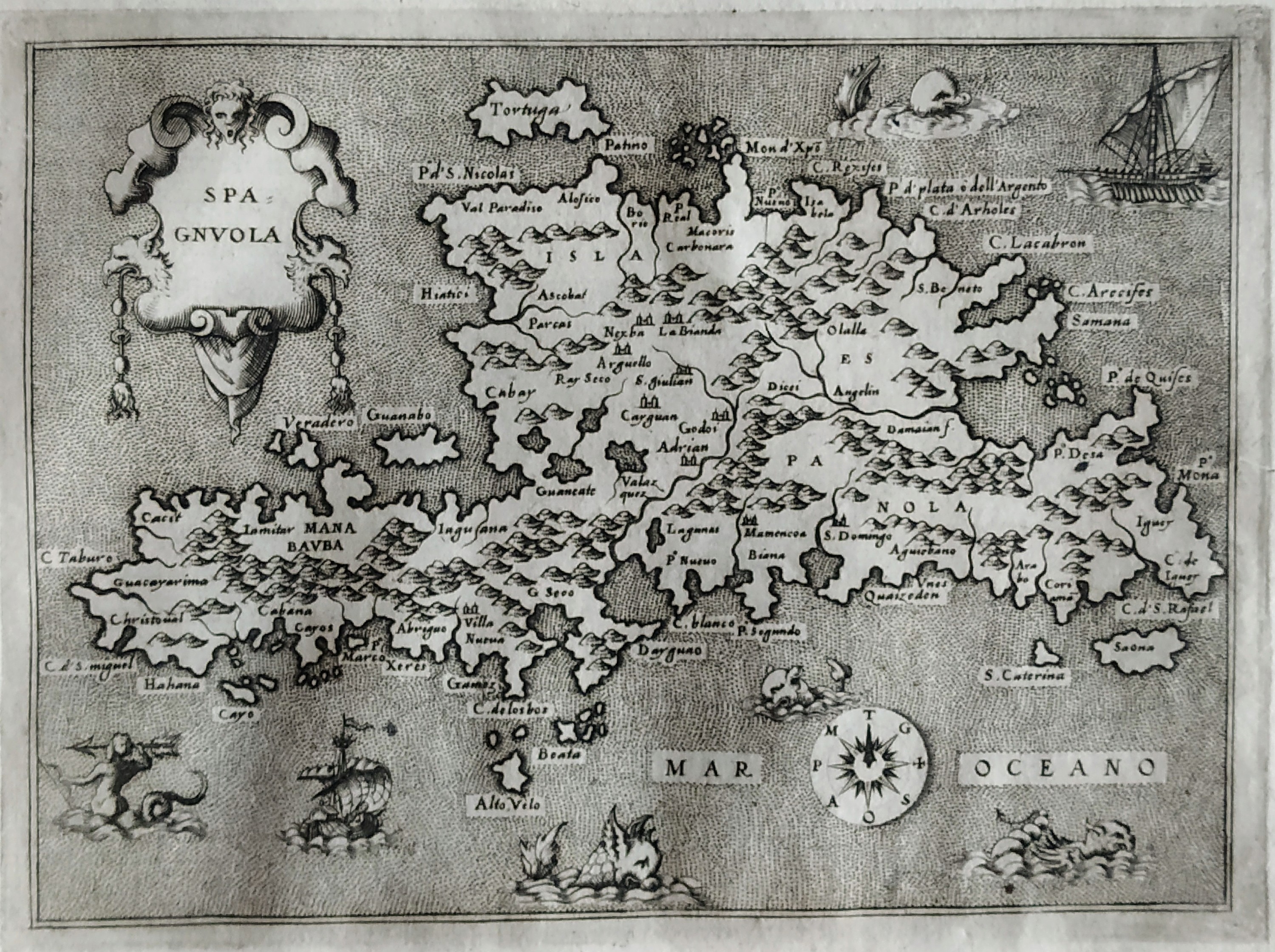
Isola Spaguola
Mapmakers
Gastaldi
LocationLocation shown in map
Haiti island
Edition date
1613
Edition place
Venice
Editor
Giambattista Ramusio
Atlas
Delle navigazioni e viaggi
Price
500 Euro
State
[mint/EXCELLENT/very good/good/fair/mediocre/poor]
Color
Black/white
Verso
Italian text pag.36
Size
Plate: cm (26.7 x 17.8) inches (10.51 x 7.01) Paper: cm (31.8 x 21.6) inches (12.52 x 8.5)
Technique
Woodcut
Note
Decorated with sea monsters and sailing ships.
Reference
--
Wiki
Here for more info
In stock
Available
Info
info@thetreasuremaps.com
Code
#0338
Isola Spaguola
Mapmakers
Gastaldi
Haiti island
Edition date
1613
Edition place
Venice
Editor
Giambattista Ramusio
Atlas
Delle navigazioni e viaggi
Price
500 Euro
State
[mint/EXCELLENT/very good/good/fair/mediocre/poor]
Color
Black/white
Verso
Italian text pag.36
Size
Plate: cm (26.7 x 17.8) inches (10.51 x 7.01) Paper: cm (31.8 x 21.6) inches (12.52 x 8.5)
Technique
Woodcut
Note
Decorated with sea monsters and sailing ships.
Reference
--
Wiki
Here for more info
In stock
Available
Info
info@thetreasuremaps.com
Code
#0338
×
![]()
Map title
Isola Spaguola
Mapmakers
Gastaldi
LocationLocation shown in map
Haiti island
Edition date
1613
Edition place
Venice
Editor
Giambattista Ramusio
Atlas
Delle navigazioni e viaggi
Price
500 Euro
State
[mint/EXCELLENT/very good/good/fair/mediocre/poor]
Color
Black/white
Verso
Italian text pag.36
Size
Plate: cm (26.7 x 17.8) inches (10.51 x 7.01) Paper: cm (31.8 x 21.6) inches (12.52 x 8.5)
Technique
Woodcut
Note
Decorated with sea monsters and sailing ships.
Reference
--
Wiki
Here for more info
In stock
Available
Info
info@thetreasuremaps.com
Code
#0729
Isola Spaguola
Mapmakers
Gastaldi
Haiti island
Edition date
1613
Edition place
Venice
Editor
Giambattista Ramusio
Atlas
Delle navigazioni e viaggi
Price
500 Euro
State
[mint/EXCELLENT/very good/good/fair/mediocre/poor]
Color
Black/white
Verso
Italian text pag.36
Size
Plate: cm (26.7 x 17.8) inches (10.51 x 7.01) Paper: cm (31.8 x 21.6) inches (12.52 x 8.5)
Technique
Woodcut
Note
Decorated with sea monsters and sailing ships.
Reference
--
Wiki
Here for more info
In stock
Available
Info
info@thetreasuremaps.com
Code
#0729
×
![]()
Map title
Descrittione dell'isola di Iamaica
Mapmakers
Porcacchi
LocationLocation shown in map
Jamaica
Edition date
1620
Edition place
Venice
Editor
--
Atlas
L'Isole piu famose del mondo -- Pietr'Antonio Brigonci
Price
200 Euro
State
[MINT/excellent/very good/good/fair/mediocre/poor]
Color
Black/white
Verso
Italian text pag.176
Size
Plate: cm (14 x 11.4) inches (5.51 x 4.49) Paper: cm (20.3 x 29) inches (7.99 x 11.42)
Technique
Copper engraving
Note
No particular notes for this maps
Reference
--
Wiki
Here for more info
In stock
Available
Info
info@thetreasuremaps.com
Code
#0746
Descrittione dell'isola di Iamaica
Mapmakers
Porcacchi
Jamaica
Edition date
1620
Edition place
Venice
Editor
--
Atlas
L'Isole piu famose del mondo -- Pietr'Antonio Brigonci
Price
200 Euro
State
[MINT/excellent/very good/good/fair/mediocre/poor]
Color
Black/white
Verso
Italian text pag.176
Size
Plate: cm (14 x 11.4) inches (5.51 x 4.49) Paper: cm (20.3 x 29) inches (7.99 x 11.42)
Technique
Copper engraving
Note
No particular notes for this maps
Reference
--
Wiki
Here for more info
In stock
Available
Info
info@thetreasuremaps.com
Code
#0746
×
![]()
Map title
Insulae Americanae
Mapmakers
Jansson
LocationLocation shown in map
Florida & Antilles islands
Edition date
1636
Edition place
Amsterdam
Editor
--
Atlas
--
Price
900 Euro
State
[mint/EXCELLENT/verygood/good/fair/mediocre/poor] Professionally restored
Color
Black/white
Verso
Latin text
Size
Plate: cm (50.8 x 38.1) inches (20 x 15) Paper: cm (53.3 x 43.2) inches (20.98 x 17.01)
Technique
Copper engraving
Note
Professionally repaired
Reference
--
Wiki
Here for more info
In stock
Available
Info
info@thetreasuremaps.com
Code
#0344
Insulae Americanae
Mapmakers
Jansson
Florida & Antilles islands
Edition date
1636
Edition place
Amsterdam
Editor
--
Atlas
--
Price
900 Euro
State
[mint/EXCELLENT/verygood/good/fair/mediocre/poor] Professionally restored
Color
Black/white
Verso
Latin text
Size
Plate: cm (50.8 x 38.1) inches (20 x 15) Paper: cm (53.3 x 43.2) inches (20.98 x 17.01)
Technique
Copper engraving
Note
Professionally repaired
Reference
--
Wiki
Here for more info
In stock
Available
Info
info@thetreasuremaps.com
Code
#0344
×
![]()
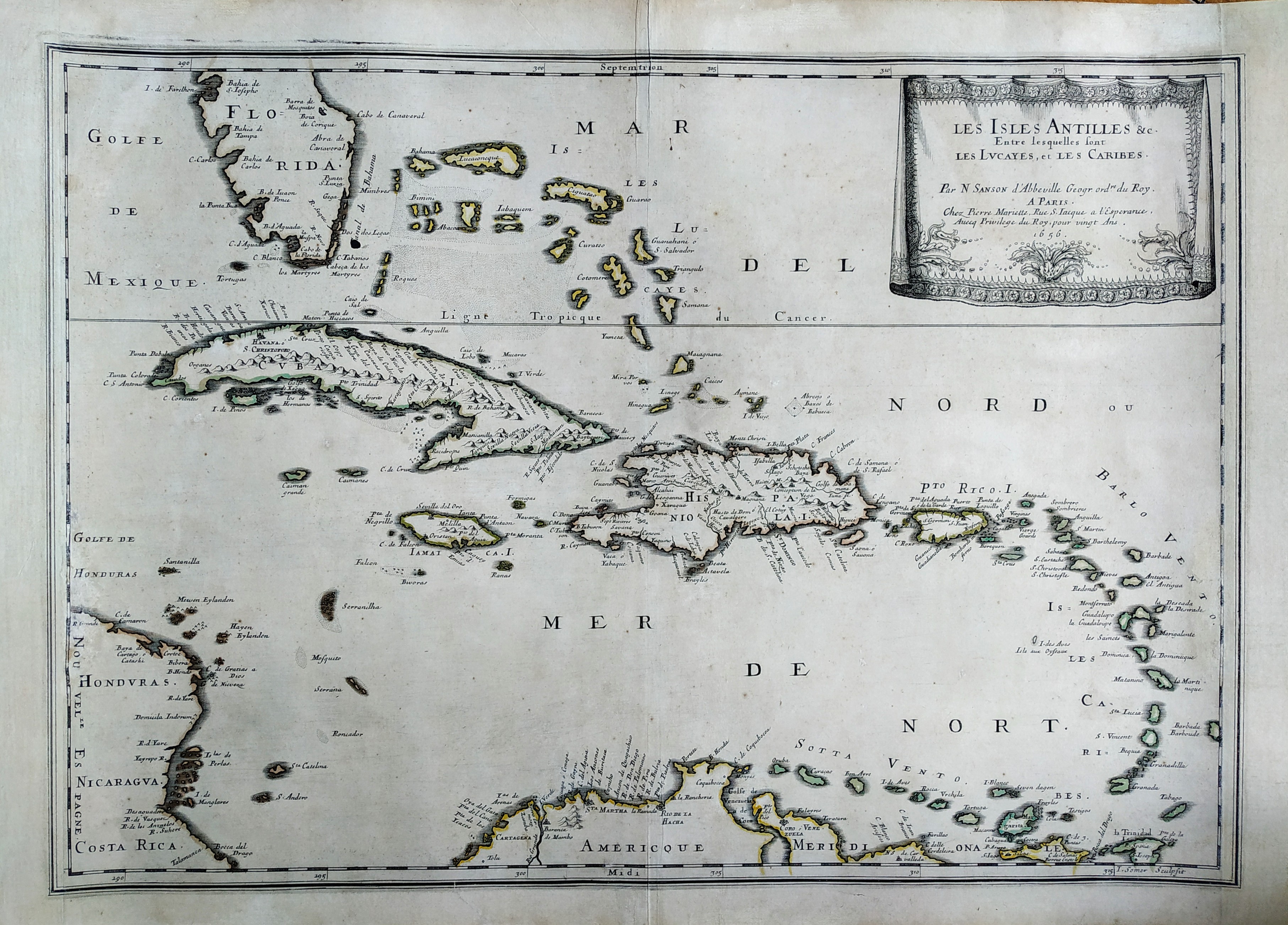
Map title
Les isles Antilles
Mapmakers
Sanson
LocationLocation shown in map
Antilles islands
Edition date
1656
Edition place
Paris
Editor
--
Atlas
Cartes generales de toutes les parties du monde -- Pierre Mariette
Price
600 Euro
State
[mint/EXCELLENT/very good/good/fair/mediocre/poor]
Color
Black/white
Verso
Blank
Size
Plate: cm (53.3 x 38.1) inches (20.98 x 15) Paper: cm (53.3 x 43.2) inches (20.98 x 17.01)
Technique
Copper engraving
Note
Professionally repaired
Reference
--
Wiki
Here for more info
In stock
Available
Info
info@thetreasuremaps.com
Code
#0343
Les isles Antilles
Mapmakers
Sanson
Antilles islands
Edition date
1656
Edition place
Paris
Editor
--
Atlas
Cartes generales de toutes les parties du monde -- Pierre Mariette
Price
600 Euro
State
[mint/EXCELLENT/very good/good/fair/mediocre/poor]
Color
Black/white
Verso
Blank
Size
Plate: cm (53.3 x 38.1) inches (20.98 x 15) Paper: cm (53.3 x 43.2) inches (20.98 x 17.01)
Technique
Copper engraving
Note
Professionally repaired
Reference
--
Wiki
Here for more info
In stock
Available
Info
info@thetreasuremaps.com
Code
#0343
×
![]()
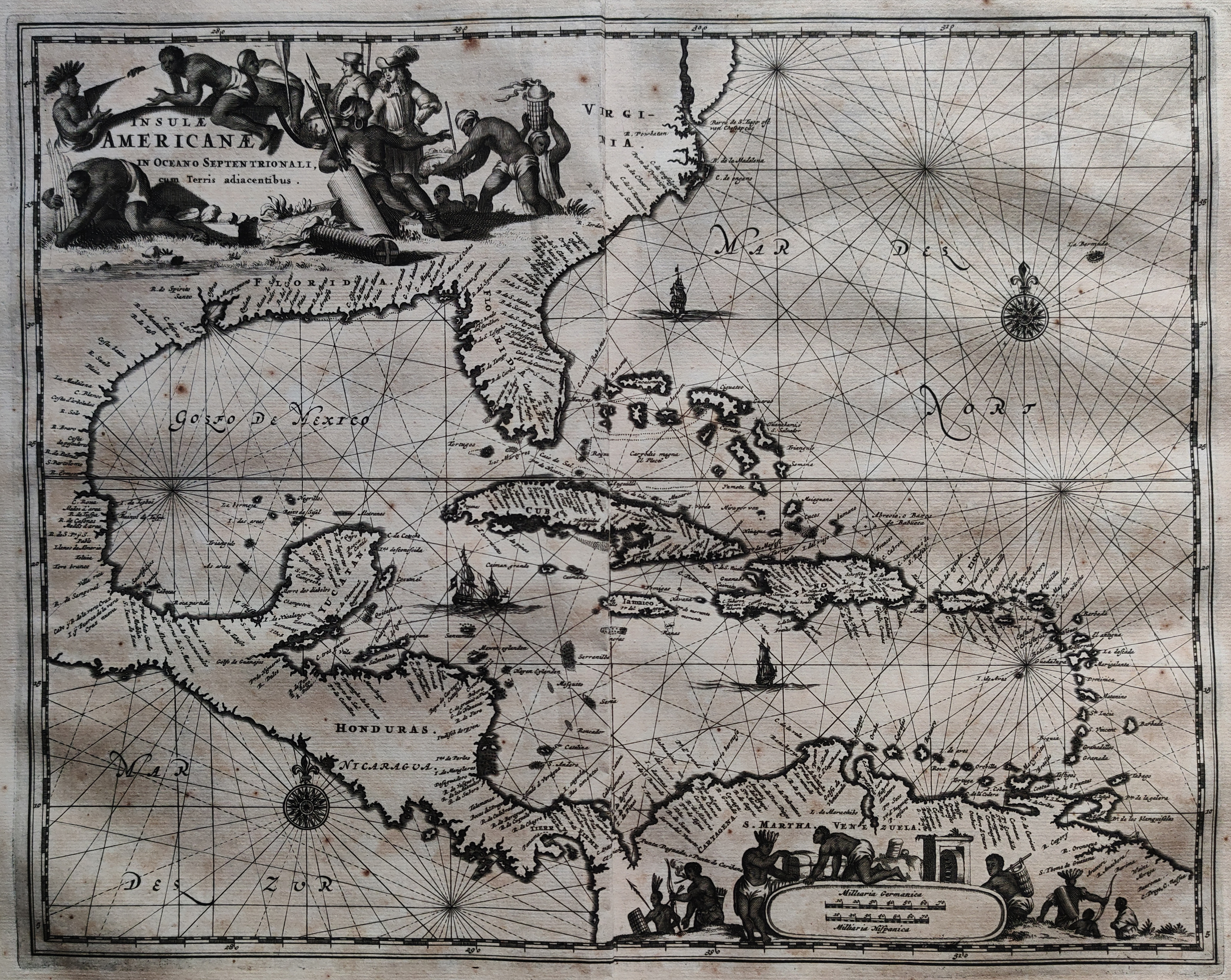
Map title
Insulae Americanae in Oceano Septentrionali, cum Terris adiacentibus.
Mapmakers
Ogilby
LocationLocation shown in map
Florida & Antilles islands
Edition date
1671
Edition place
London
Editor
Atlas
Price
500 Euro
State
[mint/EXCELLENT/very good/good/fair/mediocre/poor]
Color
Black/white
Verso
Blank
Size
Plate: cm (36 x 29) inches (14.17 x 11.42) Paper: cm (46 x 41) inches (18.11 x 16.14)
Technique
Copper engraving
Note
Reference
Wiki
Here for more info
In stock
Available
Info
info@thetreasuremaps.com
Code
#1094
Insulae Americanae in Oceano Septentrionali, cum Terris adiacentibus.
Mapmakers
Ogilby
Florida & Antilles islands
Edition date
1671
Edition place
London
Editor
Atlas
Price
500 Euro
State
[mint/EXCELLENT/very good/good/fair/mediocre/poor]
Color
Black/white
Verso
Blank
Size
Plate: cm (36 x 29) inches (14.17 x 11.42) Paper: cm (46 x 41) inches (18.11 x 16.14)
Technique
Copper engraving
Note
Reference
Wiki
Here for more info
In stock
Available
Info
info@thetreasuremaps.com
Code
#1094
×
![]()
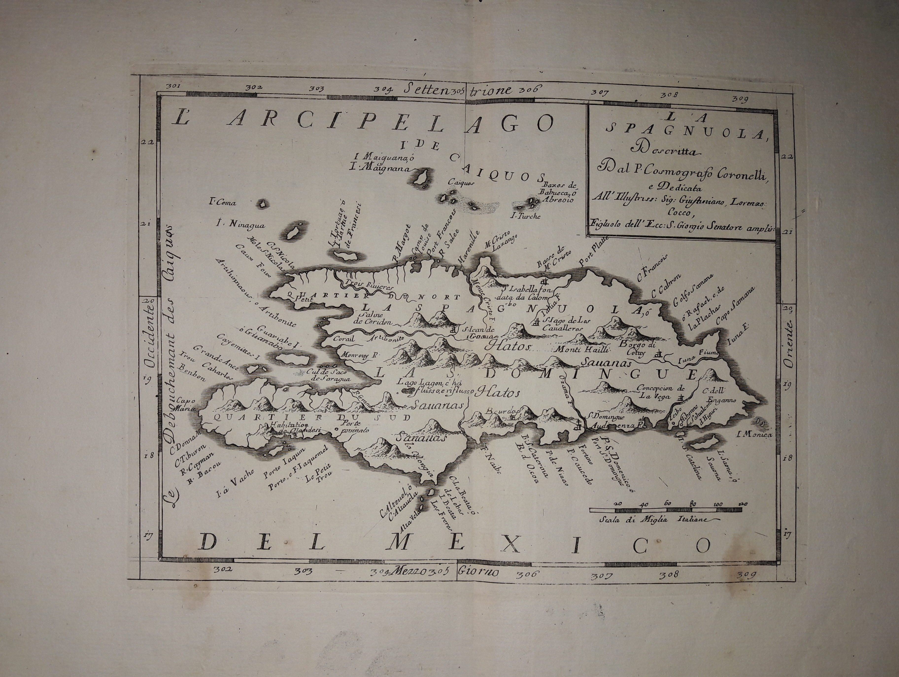
Map title
La Spagnuola
Mapmakers
Coronelli
LocationLocation shown in map
Haiti
Edition date
Circa 1690
Edition place
Venice
Editor
Atlas
Atlante veneto
Price
300 Euro
State
[mint/EXCELLENT/very good/good/fair/mediocre/poor]
Color
Black/white
Verso
Blank
Size
Plate: cm (30 x 22) inches (11.81 x 8.66) Paper: cm (43 x 32) inches (16.93 x 12.6)
Technique
Copper engraving
Note
No particular notes for this maps.
Reference
--
Wiki
Here for more info
In stock
Available
Info
info@thetreasuremaps.com
Code
#0636
La Spagnuola
Mapmakers
Coronelli
Haiti
Edition date
Circa 1690
Edition place
Venice
Editor
Atlas
Atlante veneto
Price
300 Euro
State
[mint/EXCELLENT/very good/good/fair/mediocre/poor]
Color
Black/white
Verso
Blank
Size
Plate: cm (30 x 22) inches (11.81 x 8.66) Paper: cm (43 x 32) inches (16.93 x 12.6)
Technique
Copper engraving
Note
No particular notes for this maps.
Reference
--
Wiki
Here for more info
In stock
Available
Info
info@thetreasuremaps.com
Code
#0636
×
![]()
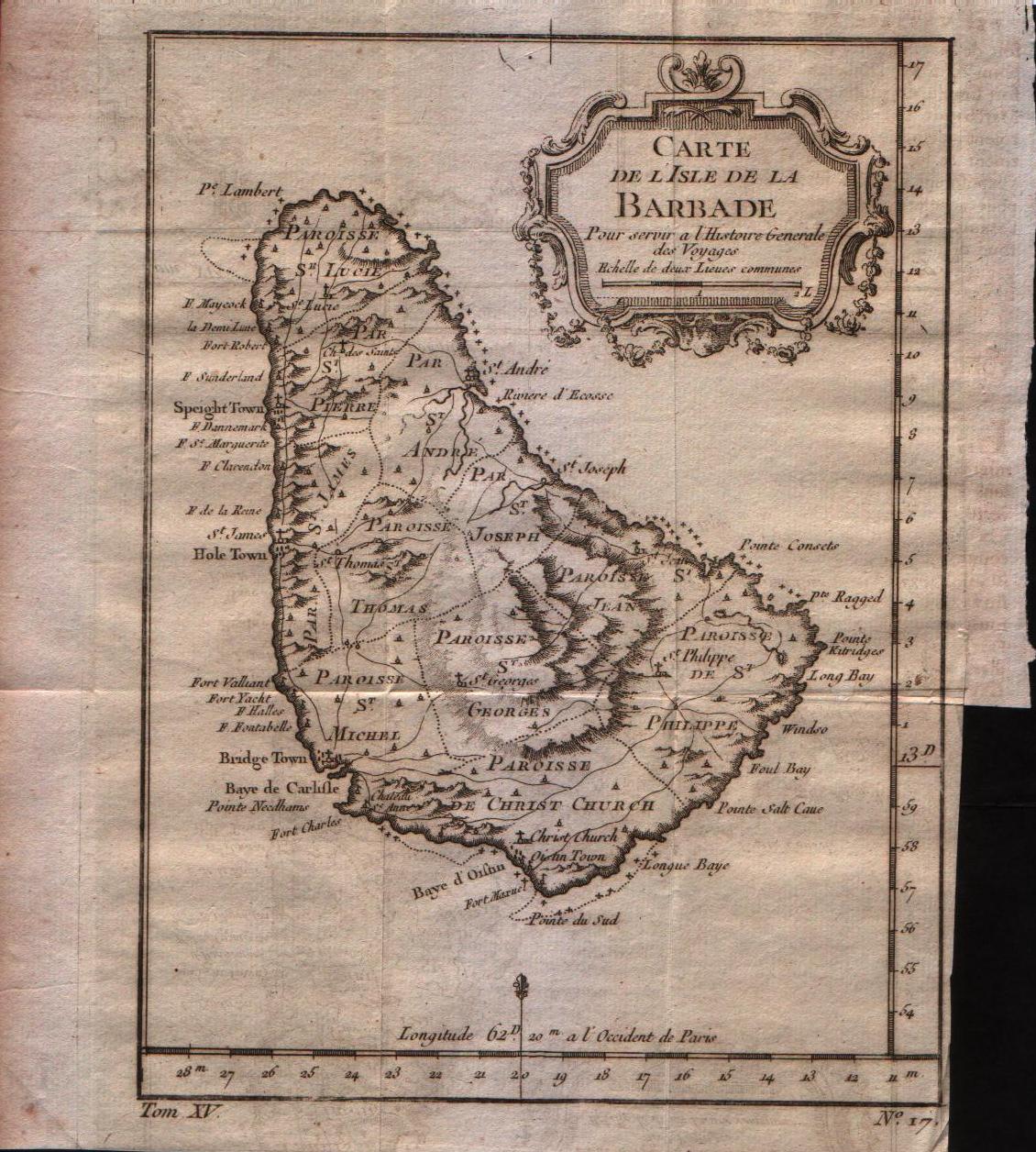
Map title
Carte de l'isle de la Barbade
Mapmakers
Bellin
LocationLocation shown in map
Barbados
Edition date
1757
Edition place
Paris
Editor
--
Atlas
Historie General des Voyages -- Prevost
Price
150 Euro
State
[mint/EXCELLENT/very good/good/fair/mediocre/poor]
Color
Black/white
Verso
Blank
Size
Plate: cm (15.2 x 20.3) inches (5.98 x 7.99) Paper: cm (17.8 x 22.9) inches (7.01 x 9.02)
Technique
Copper engraving
Note
No particular notes for this maps
Reference
--
Wiki
Here for more info
In stock
Available
Info
info@thetreasuremaps.com
Code
#0347
Carte de l'isle de la Barbade
Mapmakers
Bellin
Barbados
Edition date
1757
Edition place
Paris
Editor
--
Atlas
Historie General des Voyages -- Prevost
Price
150 Euro
State
[mint/EXCELLENT/very good/good/fair/mediocre/poor]
Color
Black/white
Verso
Blank
Size
Plate: cm (15.2 x 20.3) inches (5.98 x 7.99) Paper: cm (17.8 x 22.9) inches (7.01 x 9.02)
Technique
Copper engraving
Note
No particular notes for this maps
Reference
--
Wiki
Here for more info
In stock
Available
Info
info@thetreasuremaps.com
Code
#0347
×
![]()
Map title
Carte de lisle de la Jamaique
Mapmakers
Bellin
LocationLocation shown in map
Jamaica
Edition date
1757
Edition place
Paris
Editor
--
Atlas
Historie General des Voyages -- Prevost
Price
150 Euro
State
[mint/excellent/very good/good/fair/MEDIOCRE/poor]
Color
Black/white
Verso
Blank
Size
Plate: cm (15.2 x 20.3) inches (5.98 x 7.99) Paper: cm (30.5 x 20.3) inches (12.01 x 7.99)
Technique
Copper engraving
Note
No particular notes for this maps
Reference
--
Wiki
Here for more info
In stock
Available
Info
info@thetreasuremaps.com
Code
#0349
Carte de lisle de la Jamaique
Mapmakers
Bellin
Jamaica
Edition date
1757
Edition place
Paris
Editor
--
Atlas
Historie General des Voyages -- Prevost
Price
150 Euro
State
[mint/excellent/very good/good/fair/MEDIOCRE/poor]
Color
Black/white
Verso
Blank
Size
Plate: cm (15.2 x 20.3) inches (5.98 x 7.99) Paper: cm (30.5 x 20.3) inches (12.01 x 7.99)
Technique
Copper engraving
Note
No particular notes for this maps
Reference
--
Wiki
Here for more info
In stock
Available
Info
info@thetreasuremaps.com
Code
#0349
×
![]()
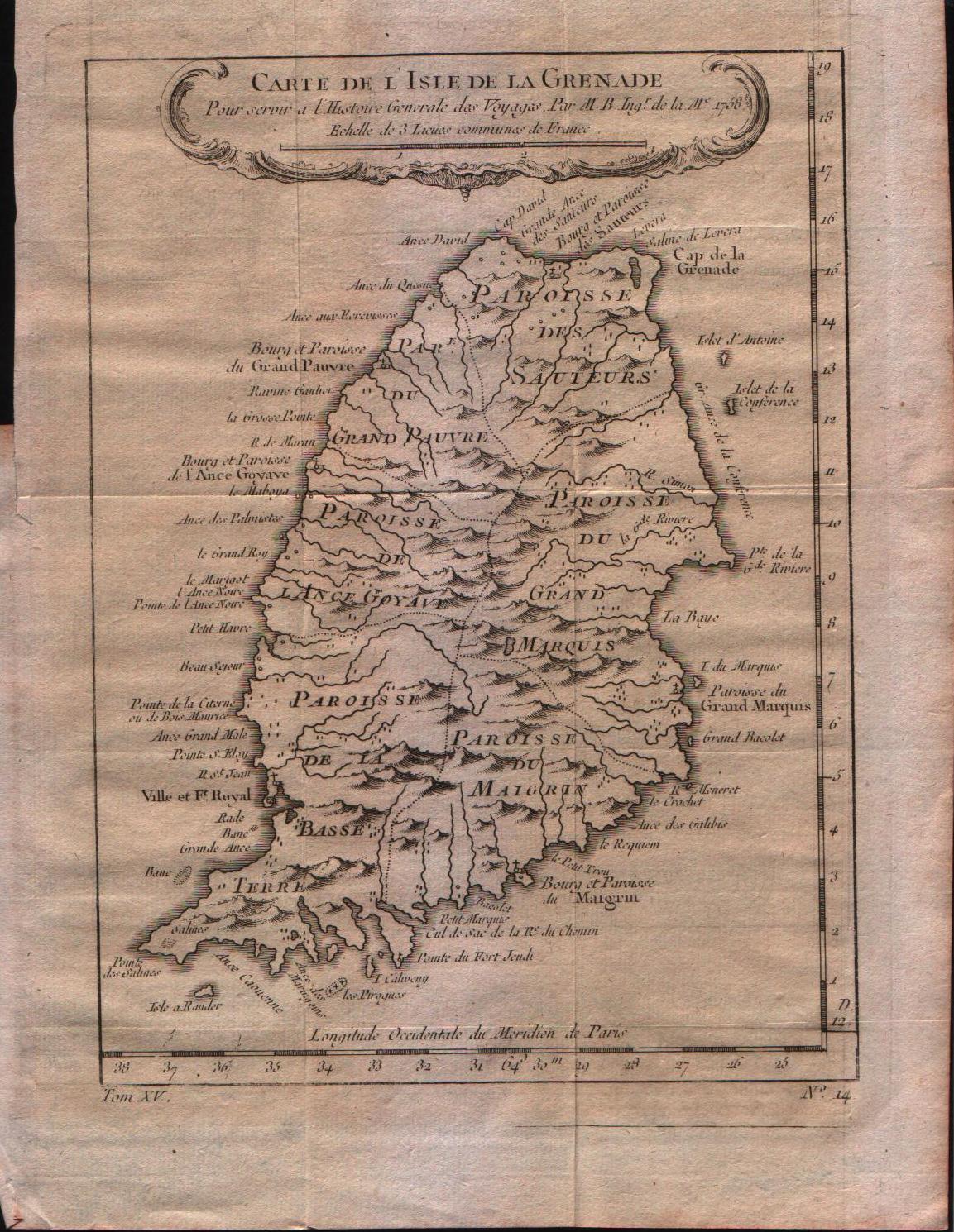
Map title
Carte de l'isle de la Grenade
Mapmakers
Bellin
LocationLocation shown in map
Grenada
Edition date
1757
Edition place
Paris
Editor
--
Atlas
Historie General des Voyages -- Prevost
Price
150 Euro
State
[mint/EXCELLENT/very good/good/fair/mediocre/poor]
Color
Black/white
Verso
Blank
Size
Plate: cm (15.2 x 21.6) inches (5.98 x 8.5) Paper: cm (20.3 x 25.4) inches (7.99 x 10)
Technique
Copper engraving
Note
No particular notes for this maps
Reference
--
Wiki
Here for more info
In stock
Available
Info
info@thetreasuremaps.com
Code
#0353
Carte de l'isle de la Grenade
Mapmakers
Bellin
Grenada
Edition date
1757
Edition place
Paris
Editor
--
Atlas
Historie General des Voyages -- Prevost
Price
150 Euro
State
[mint/EXCELLENT/very good/good/fair/mediocre/poor]
Color
Black/white
Verso
Blank
Size
Plate: cm (15.2 x 21.6) inches (5.98 x 8.5) Paper: cm (20.3 x 25.4) inches (7.99 x 10)
Technique
Copper engraving
Note
No particular notes for this maps
Reference
--
Wiki
Here for more info
In stock
Available
Info
info@thetreasuremaps.com
Code
#0353
×
![]()
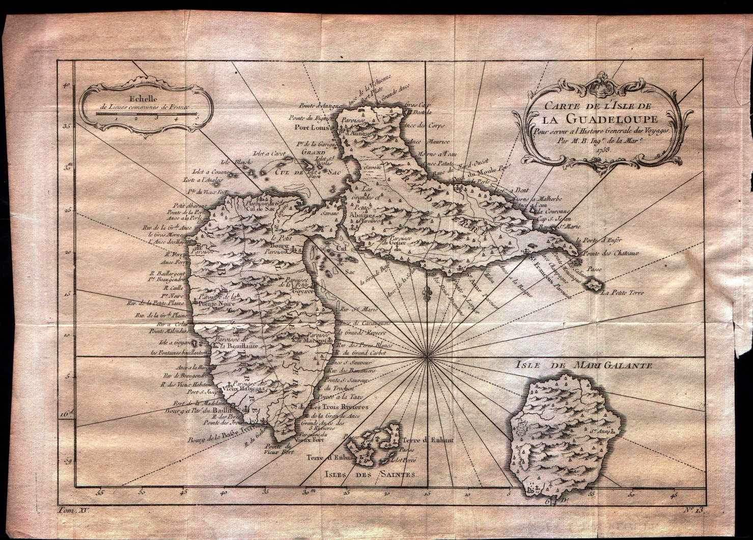
Map title
Carte de l'isle de la Guadeloupe
Mapmakers
Bellin
LocationLocation shown in map
Guadeloupe
Edition date
1757
Edition place
Paris
Editor
--
Atlas
Historie General des Voyages -- Prevost
Price
150 Euro
State
[mint/EXCELLENT/very good/good/fair/mediocre/poor]
Color
Black/white
Verso
Blank
Size
Plate: cm (30.5 x 21.6) inches (12.01 x 8.5) Paper: cm (34.3 x 25.4) inches (13.5 x 10)
Technique
Copper engraving
Note
No particular notes for this maps
Reference
--
Wiki
Here for more info
In stock
Available
Info
info@thetreasuremaps.com
Code
#0354
Carte de l'isle de la Guadeloupe
Mapmakers
Bellin
Guadeloupe
Edition date
1757
Edition place
Paris
Editor
--
Atlas
Historie General des Voyages -- Prevost
Price
150 Euro
State
[mint/EXCELLENT/very good/good/fair/mediocre/poor]
Color
Black/white
Verso
Blank
Size
Plate: cm (30.5 x 21.6) inches (12.01 x 8.5) Paper: cm (34.3 x 25.4) inches (13.5 x 10)
Technique
Copper engraving
Note
No particular notes for this maps
Reference
--
Wiki
Here for more info
In stock
Available
Info
info@thetreasuremaps.com
Code
#0354
×
![]()
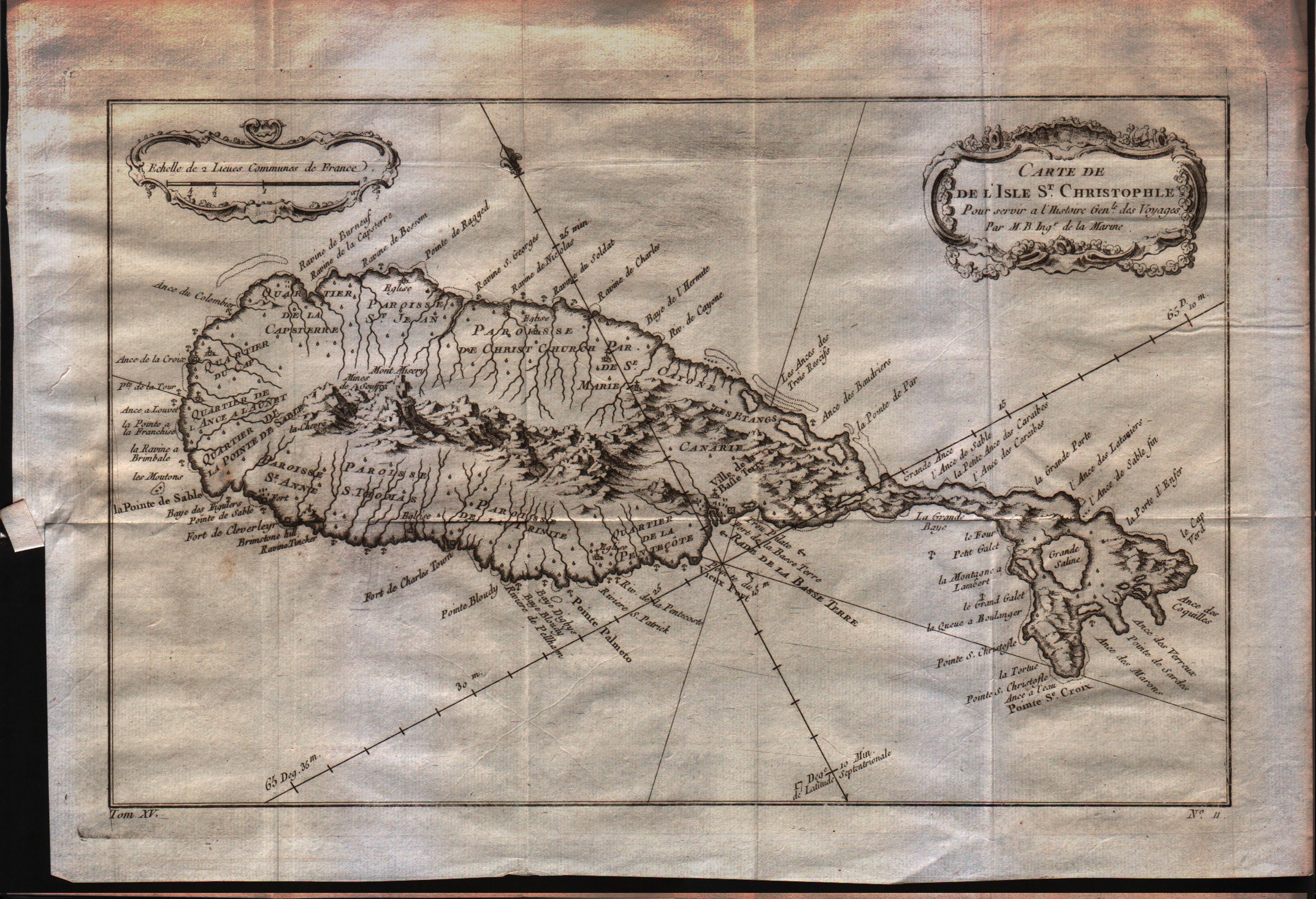
Map title
Carte de l'isle St.Christophle
Mapmakers
Bellin
LocationLocation shown in map
St.Christopher
Edition date
1757
Edition place
Paris
Editor
--
Atlas
Historie General des Voyages -- Prevost
Price
150 Euro
State
[mint/EXCELLENT/very good/good/fair/mediocre/poor]
Color
Black/white
Verso
Blank
Size
Plate: cm (30.5 x 20.3) inches (12.01 x 7.99) Paper: cm (34.3 x 24.1) inches (13.5 x 9.49)
Technique
Copper engraving
Note
No particular notes for this maps
Reference
--
Wiki
Here for more info
In stock
Available
Info
info@thetreasuremaps.com
Code
#0355
Carte de l'isle St.Christophle
Mapmakers
Bellin
St.Christopher
Edition date
1757
Edition place
Paris
Editor
--
Atlas
Historie General des Voyages -- Prevost
Price
150 Euro
State
[mint/EXCELLENT/very good/good/fair/mediocre/poor]
Color
Black/white
Verso
Blank
Size
Plate: cm (30.5 x 20.3) inches (12.01 x 7.99) Paper: cm (34.3 x 24.1) inches (13.5 x 9.49)
Technique
Copper engraving
Note
No particular notes for this maps
Reference
--
Wiki
Here for more info
In stock
Available
Info
info@thetreasuremaps.com
Code
#0355
×
![]()
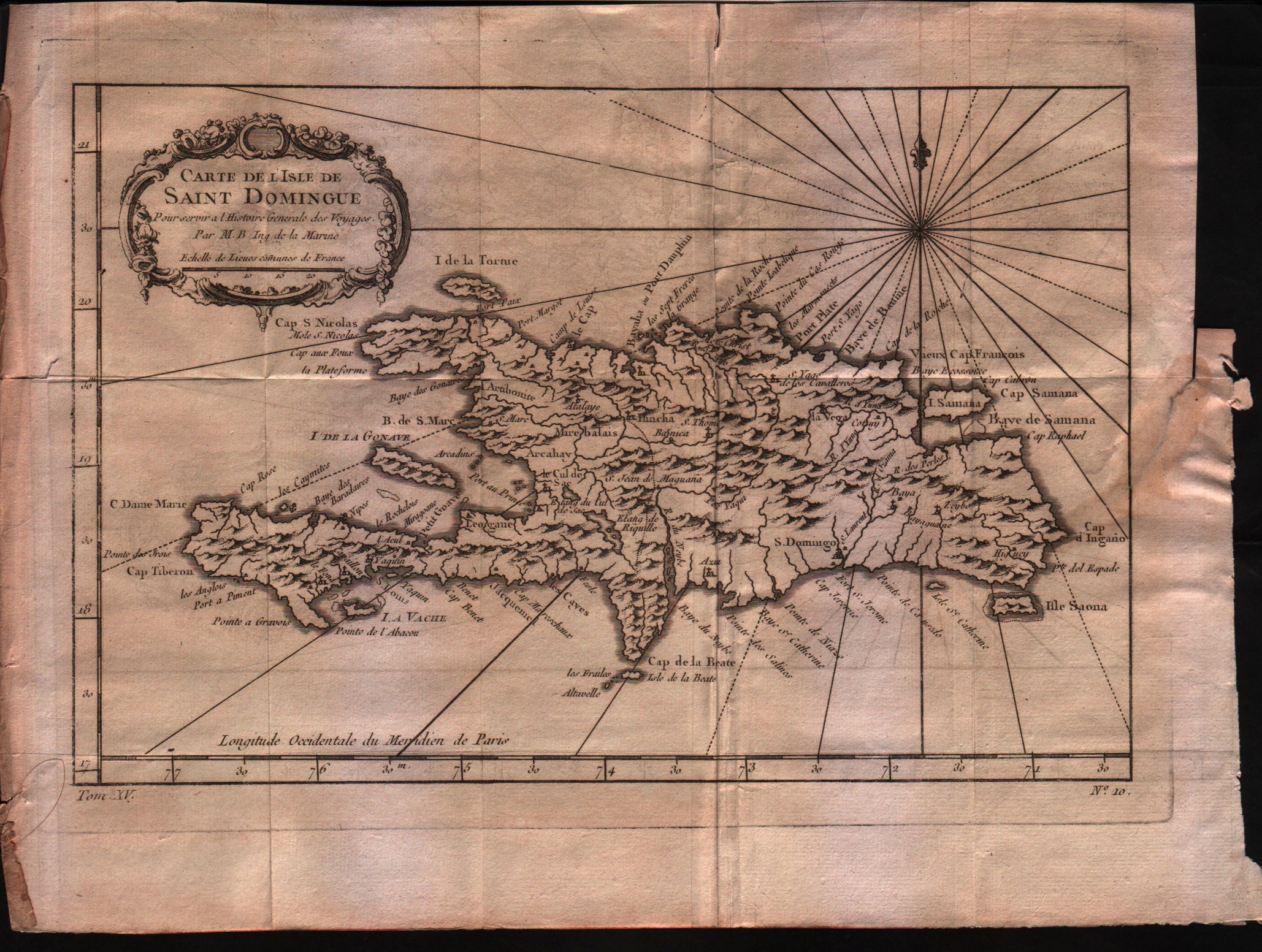
Map title
Carte de l'isle de Saint Domingue
Mapmakers
Bellin
LocationLocation shown in map
Haiti
Edition date
1757
Edition place
Paris
Editor
--
Atlas
Historie General des Voyages -- Prevost
Price
150 Euro
State
[mint/EXCELLENT/very good/good/fair/mediocre/poor]
Color
Black/white
Verso
Blank
Size
Plate: cm (27.9 x 20.3) inches (10.98 x 7.99) Paper: cm (33 x 25.4) inches (12.99 x 10)
Technique
Copper engraving
Note
No particular notes for this maps
Reference
--
Wiki
Here for more info
In stock
Available
Info
info@thetreasuremaps.com
Code
#0356
Carte de l'isle de Saint Domingue
Mapmakers
Bellin
Haiti
Edition date
1757
Edition place
Paris
Editor
--
Atlas
Historie General des Voyages -- Prevost
Price
150 Euro
State
[mint/EXCELLENT/very good/good/fair/mediocre/poor]
Color
Black/white
Verso
Blank
Size
Plate: cm (27.9 x 20.3) inches (10.98 x 7.99) Paper: cm (33 x 25.4) inches (12.99 x 10)
Technique
Copper engraving
Note
No particular notes for this maps
Reference
--
Wiki
Here for more info
In stock
Available
Info
info@thetreasuremaps.com
Code
#0356
×
![]()
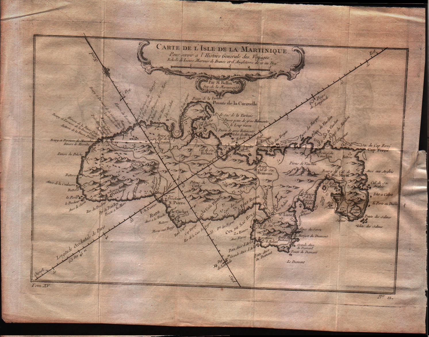
Map title
Carte de l'isle de la Martinique
Mapmakers
Bellin
LocationLocation shown in map
Martinique
Edition date
1757
Edition place
Paris
Editor
--
Atlas
Historie General des Voyages -- Prevost
Price
150 Euro
State
[mint/EXCELLENT/very good/good/fair/mediocre/poor]
Color
Black/white
Verso
Blank
Size
Plate: cm (29.2 x 20.3) inches (11.5 x 7.99) Paper: cm (34.3 x 25.4) inches (13.5 x 10)
Technique
Copper engraving
Note
No particular notes for this maps
Reference
--
Wiki
Here for more info
In stock
Available
Info
info@thetreasuremaps.com
Code
#0357
Carte de l'isle de la Martinique
Mapmakers
Bellin
Martinique
Edition date
1757
Edition place
Paris
Editor
--
Atlas
Historie General des Voyages -- Prevost
Price
150 Euro
State
[mint/EXCELLENT/very good/good/fair/mediocre/poor]
Color
Black/white
Verso
Blank
Size
Plate: cm (29.2 x 20.3) inches (11.5 x 7.99) Paper: cm (34.3 x 25.4) inches (13.5 x 10)
Technique
Copper engraving
Note
No particular notes for this maps
Reference
--
Wiki
Here for more info
In stock
Available
Info
info@thetreasuremaps.com
Code
#0357
×
![]()
Map title
Carta dell'isola di Santa Lucia
Mapmakers
Bellin
LocationLocation shown in map
Sant Lucia
Edition date
1760
Edition place
Paris
Editor
--
Atlas
Historie General des Voyages -- Prevost
Price
150 Euro
State
[mint/EXCELLENT/very good/good/fair/mediocre/poor]
Color
Black/white
Verso
Blank
Size
Plate: cm (30 x 20) inches (11.81 x 7.87) Paper: cm (33 x 23) inches (12.99 x 9.06)
Technique
Copper engraving
Note
Reference
--
Wiki
Here for more info
In stock
Available
Info
info@thetreasuremaps.com
Code
#1172
Carta dell'isola di Santa Lucia
Mapmakers
Bellin
Sant Lucia
Edition date
1760
Edition place
Paris
Editor
--
Atlas
Historie General des Voyages -- Prevost
Price
150 Euro
State
[mint/EXCELLENT/very good/good/fair/mediocre/poor]
Color
Black/white
Verso
Blank
Size
Plate: cm (30 x 20) inches (11.81 x 7.87) Paper: cm (33 x 23) inches (12.99 x 9.06)
Technique
Copper engraving
Note
Reference
--
Wiki
Here for more info
In stock
Available
Info
info@thetreasuremaps.com
Code
#1172
×
![]()
Map title
Carte du Golphe du Mexique et des Isles de l'Amerique
Mapmakers
Bellin
LocationLocation shown in map
--
Edition date
1773
Edition place
Amsterdam
Editor
--
Atlas
Atlas Portatif -- E. van Harrevelt
Price
275 Euro
State
[mint/EXCELLENT/very good/good/fair/mediocre/poor]
Color
Old colors
Verso
Blank
Size
Plate: cm (36.8 x 26.7) inches (14.49 x 10.51) Paper: cm (39.4 x 31.8) inches (15.51 x 12.52)
Technique
Copper engraving
Note
No particular notes for this maps
Reference
--
Wiki
Here for more info
In stock
Available
Info
info@thetreasuremaps.com
Code
#0071
Carte du Golphe du Mexique et des Isles de l'Amerique
Mapmakers
Bellin
--
Edition date
1773
Edition place
Amsterdam
Editor
--
Atlas
Atlas Portatif -- E. van Harrevelt
Price
275 Euro
State
[mint/EXCELLENT/very good/good/fair/mediocre/poor]
Color
Old colors
Verso
Blank
Size
Plate: cm (36.8 x 26.7) inches (14.49 x 10.51) Paper: cm (39.4 x 31.8) inches (15.51 x 12.52)
Technique
Copper engraving
Note
No particular notes for this maps
Reference
--
Wiki
Here for more info
In stock
Available
Info
info@thetreasuremaps.com
Code
#0071
×
![]()

Map title
Les Isle Antilles Et Le Golfe Du Mexique
Mapmakers
Bonne
LocationLocation shown in map
--
Edition date
1787
Edition place
Paris
Editor
--
Atlas
Atlas Encyclopedique
Price
Please ask: info@thetreasuremaps.com
State
[mint/excellent/very good/GOOD/fair/mediocre/poor]
Color
Modern outlined
Verso
Blank
Size
Plate: cm (31.8 x 21) inches (12.52 x 8.27) Paper: cm (36.8 x 25.4) inches (14.49 x 10)
Technique
Copper engraving
Note
No particular notes for this maps
Reference
--
Wiki
Here for more info
In stock
Sold
Info
info@thetreasuremaps.com
Code
#0395
Les Isle Antilles Et Le Golfe Du Mexique
Mapmakers
Bonne
--
Edition date
1787
Edition place
Paris
Editor
--
Atlas
Atlas Encyclopedique
Price
Please ask: info@thetreasuremaps.com
State
[mint/excellent/very good/GOOD/fair/mediocre/poor]
Color
Modern outlined
Verso
Blank
Size
Plate: cm (31.8 x 21) inches (12.52 x 8.27) Paper: cm (36.8 x 25.4) inches (14.49 x 10)
Technique
Copper engraving
Note
No particular notes for this maps
Reference
--
Wiki
Here for more info
In stock
Sold
Info
info@thetreasuremaps.com
Code
#0395
×
![]()
Map title
Charte von west Indien
Mapmakers
Johann Walch
LocationLocation shown in map
West Indies
Edition date
1820
Edition place
Hamburg
Editor
Atlas
Price
Please ask: info@thetreasuremaps.com
State
[mint/EXCELLENT/very good/good/fair/mediocre/poor]
Color
Old colors
Verso
Blank
Size
Plate: cm (21 x 18) inches (8.27 x 7.09) Paper: cm (26 x 22) inches (10.24 x 8.66)
Technique
Steel engraving
Note
No particular notes for this maps
Reference
Wiki
Here for more info
In stock
Available
Info
info@thetreasuremaps.com
Code
#0700
Charte von west Indien
Mapmakers
Johann Walch
West Indies
Edition date
1820
Edition place
Hamburg
Editor
Atlas
Price
Please ask: info@thetreasuremaps.com
State
[mint/EXCELLENT/very good/good/fair/mediocre/poor]
Color
Old colors
Verso
Blank
Size
Plate: cm (21 x 18) inches (8.27 x 7.09) Paper: cm (26 x 22) inches (10.24 x 8.66)
Technique
Steel engraving
Note
No particular notes for this maps
Reference
Wiki
Here for more info
In stock
Available
Info
info@thetreasuremaps.com
Code
#0700
×
![]()