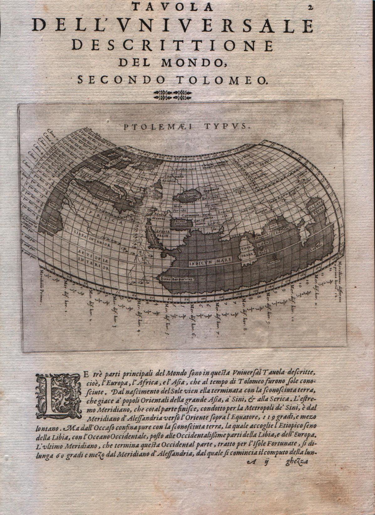
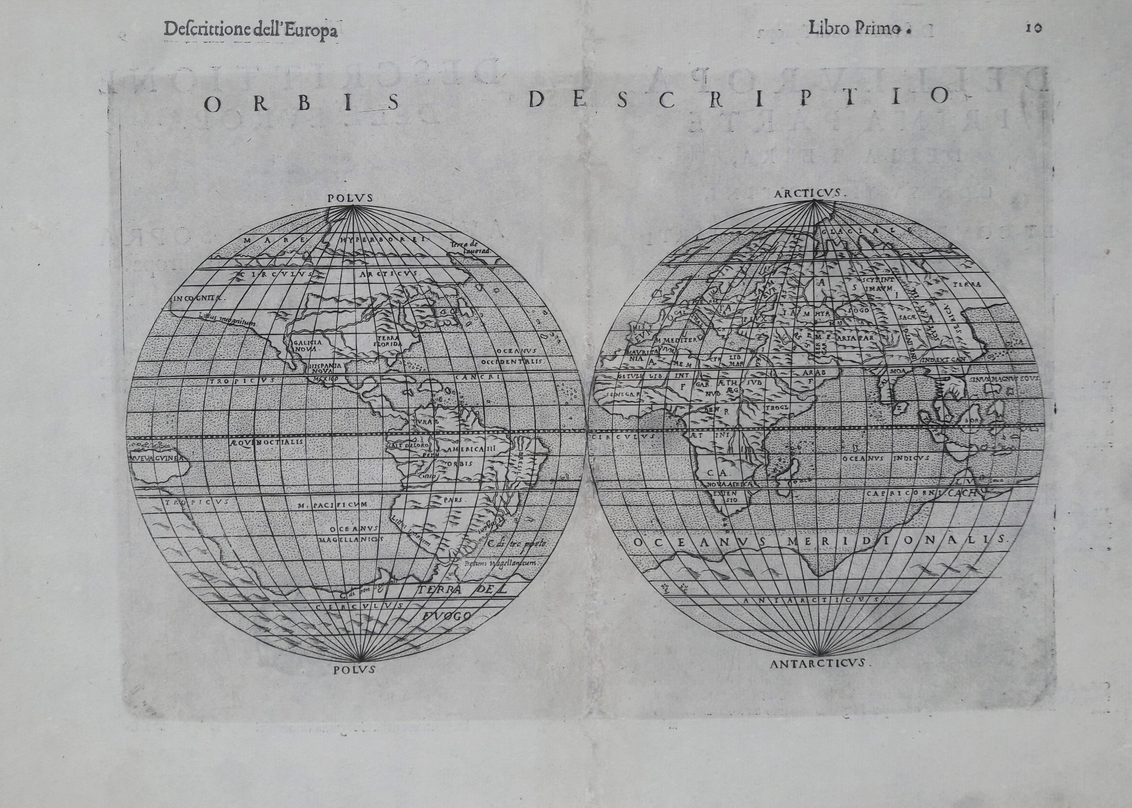
World
Map title
Das ander alter der werlt
Author
Schedel
Location shown in map
World
Edition date
1493
Edition place
Nuremberg
Editor
--
Atlas
Liber Chronicarum
Price
2500 Euro
State
[mint/EXCELLENT/very good/good/fair/mediocre/poor]
Color
Black/white
Verso
German text
Size
Plate: cm (22.9 x 22.9) inches (9.02 x 9.02) Paper: cm (29.2 x 40.6) inches (11.5 x 15.98)
Technique
Woodcut
Note
--
Reference
--
Wiki
Here for more info
In stock
Available
Info
info@thetreasuremaps.com
Code
#0640
×
![Das ander alter der werlt by Schedel, World, 1493]()
Map title
Mensura universae terrae
Author
Foresti
Location shown in map
World
Edition date
Circa 1503
Edition place
Venice
Editor
Georgii de Rusconibus
Atlas
Supplementum supplementi cronicarum
Price
3000 Euro
State
[MINT/excellent/very good/good/fair/mediocre/poor]
Color
Black/white
Verso
Latin text
Size
Plate: cm (14 x 8.9) inches (5.51 x 3.5) Paper: cm (21.6 x 30.5) inches (8.5 x 12.01)
Technique
Woodcut
Note
T-O map
Reference
--
Wiki
Here for more info
In stock
Available
Info
info@thetreasuremaps.com
Code
#0568
×
![Mensura universae terrae by Foresti, World, Circa 1503]()
Map title
Tabu nova orbis
Author
Fries
Location shown in map
World
Edition date
1535
Edition place
Lyon
Editor
Melchior and Gaspar Trechsel
Atlas
Ptolemy's Geographia
Price
4500 Euro
State
[mint/EXCELLENT/very good/good/fair/mediocre/poor] repaired
Color
Black/white
Verso
Blank
Size
Plate: cm (45 x 28) inches (17.72 x 11.02) Paper: cm (55.9 x 43) inches (22.01 x 16.93)
Technique
Woodcut
Note
Professionaly repaired
Reference
--
Wiki
Here for more info
In stock
Available
Info
info@thetreasuremaps.com
Code
#1199
×
![Tabu nova orbis by Fries, World, 1535]()
Map title
Carta marina nova tabula
Author
Ruscelli
Location shown in map
World
Edition date
1561
Edition place
Venice
Editor
Vincenzo Valgrisi
Atlas
La Geographia di Claudio Tolomeo
Price
800 Euro
State
[mint/EXCELLENT/very good/good/fair/mediocre/poor]
Color
Black/white
Verso
Size
Plate: cm (26 x 19) inches (10.24 x 7.48) Paper: cm (27.9 x 20.3) inches (10.98 x 7.99)
Technique
Copper engraving
Note
No particular notes for this maps.
Reference
--
Wiki
Here for more info
In stock
Sold
Info
info@thetreasuremaps.com
Code
#0765
×
![Carta marina nova tabula by Ruscelli, World, 1561]()
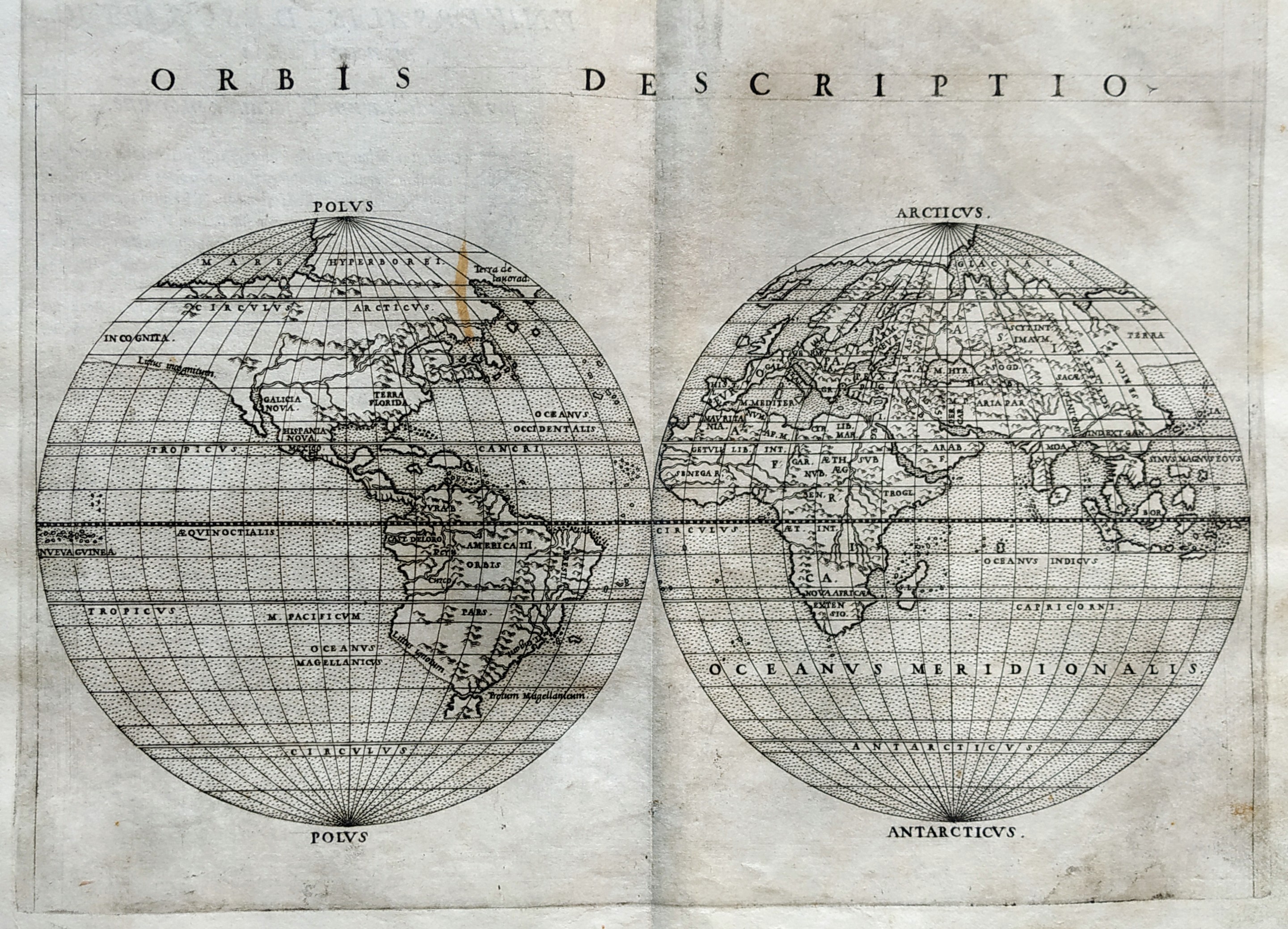
Map title
Orbis descriptio
Author
Ruscelli
Location shown in map
World
Edition date
1561
Edition place
Venice
Editor
Vincenzo Valgrisi
Atlas
La Geographia di Claudio Tolomeo
Price
700 Euro
State
[mint/EXCELLENT/very good/good/fair/mediocre/poor]
Color
Black/white
Verso
Size
Plate: cm (26 x 19) inches (10.24 x 7.48) Paper: cm (27.9 x 20.3) inches (10.98 x 7.99)
Technique
Copper engraving
Note
No particular notes for this maps.
Reference
--
Wiki
Here for more info
In stock
Sold
Info
info@thetreasuremaps.com
Code
#0766
×
![Orbis descriptio by Ruscelli, World, 1561]()
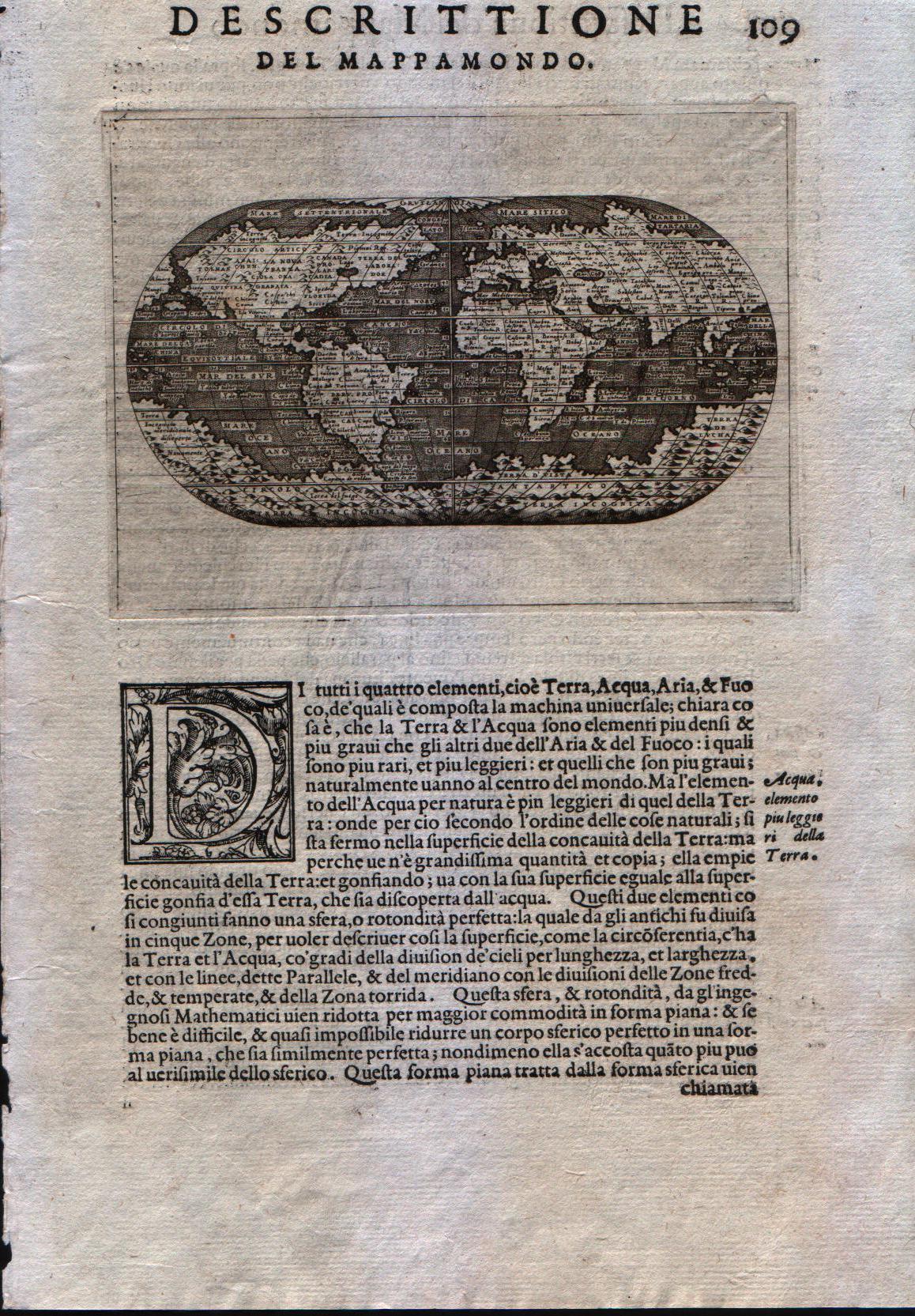
Map title
Descrittione del Mappamondo
Author
Porcacchi
Location shown in map
World
Edition date
1572
Edition place
Venice
Editor
--
Atlas
L'Isole piu famose del mondo -- S. Galignani and G. Porro
Price
600 Euro
State
[mint/EXCELLENT/very good/good/fair/mediocre/poor]
Color
Black/white
Verso
Italian text pag.109
Size
Plate: cm (15.2 x 11.4) inches (5.98 x 4.49) Paper: cm (20.3 x 29.2) inches (7.99 x 11.5)
Technique
Copper engraving
Note
First edition
Reference
--
Wiki
Here for more info
In stock
Available
Info
info@thetreasuremaps.com
Code
#0331
×
![Descrittione del Mappamondo by Porcacchi, World, 1572]()
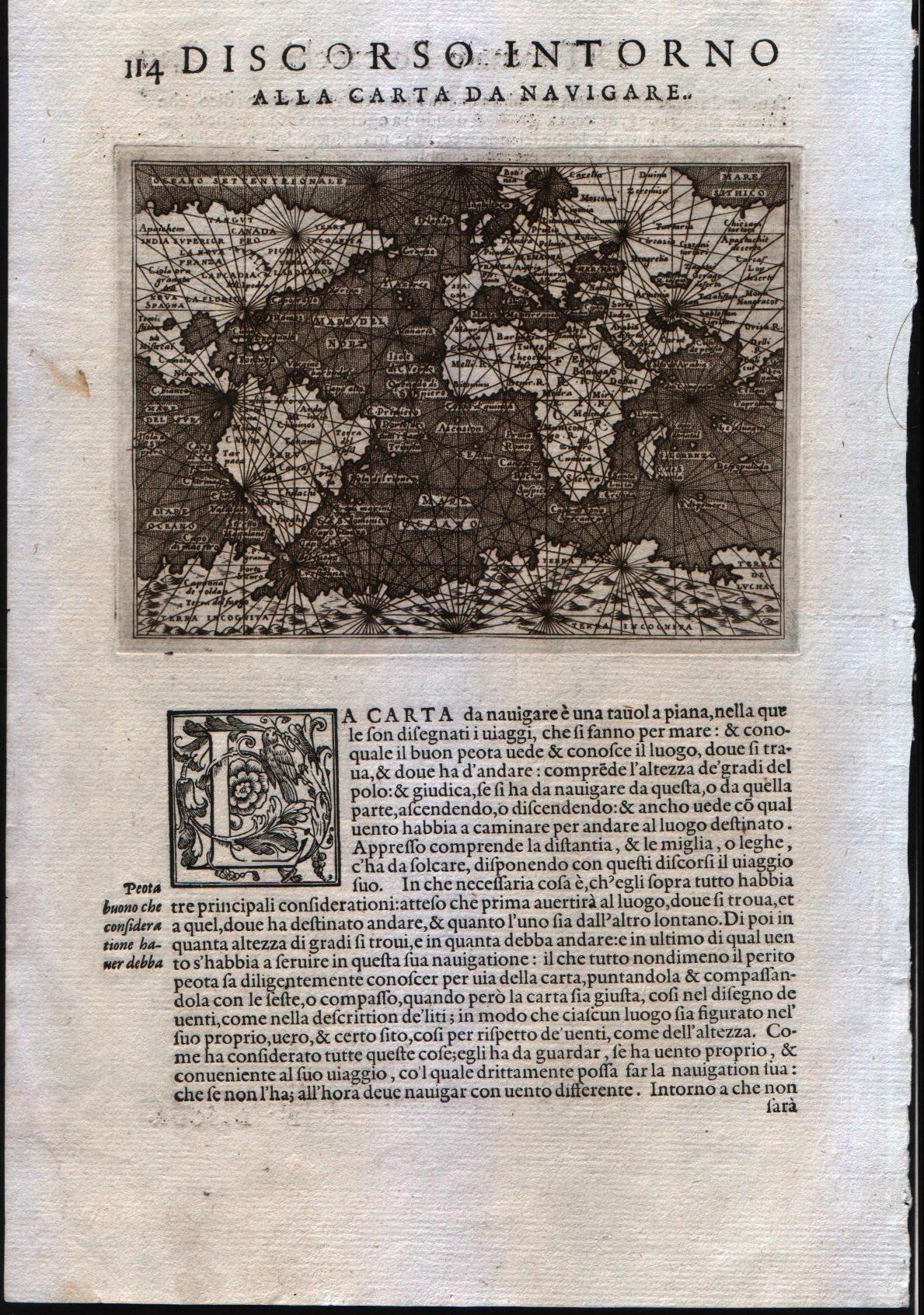
Map title
Discorso intorno alla carta da navigare
Author
Porcacchi
Location shown in map
World
Edition date
1572
Edition place
Venice
Editor
--
Atlas
L'Isole piu famose del mondo -- S. Galignani and G. Porro
Price
600 Euro
State
[mint/EXCELLENT/very good/good/fair/mediocre/poor]
Color
Black/white
Verso
Italian text pag.114
Size
Plate: cm (15.2 x 11.4) inches (5.98 x 4.49) Paper: cm (20.3 x 29.2) inches (7.99 x 11.5)
Technique
Copper engraving
Note
First edition
Reference
--
Wiki
Here for more info
In stock
Available
Info
info@thetreasuremaps.com
Code
#0332
×
![Discorso intorno alla carta da navigare by Porcacchi, World, 1572]()
Map title
Descrittione del Mappamondo
Author
Porcacchi
Location shown in map
World
Edition date
1576
Edition place
Venice
Editor
--
Atlas
L'Isole piu famose del mondo -- S. Galignani and G. Porro
Price
Please ask: info@thetreasuremaps.com
State
[mint/EXCELLENT/very good/good/fair/mediocre/poor]
Color
Black/white
Verso
Italian text pag.194
Size
Plate: cm (15.2 x 11.4) inches (5.98 x 4.49) Paper: cm (20.3 x 29.2) inches (7.99 x 11.5)
Technique
Copper engraving
Note
Reference
--
Wiki
Here for more info
In stock
Available
Info
info@thetreasuremaps.com
Code
#0837
×
![Descrittione del Mappamondo by Porcacchi, World, 1576]()
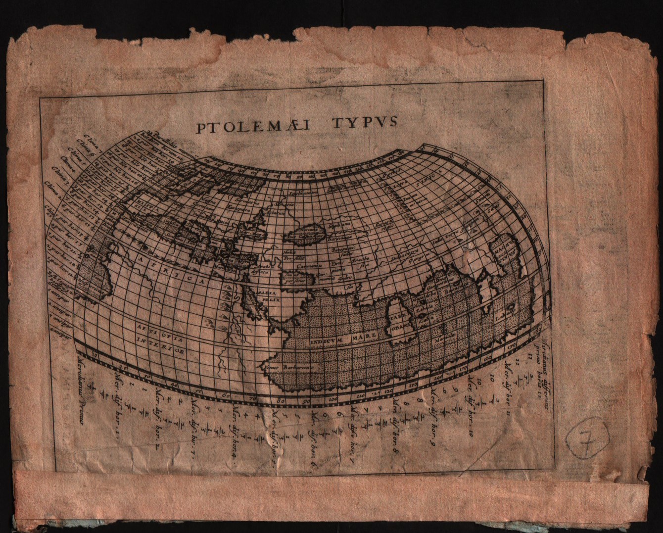
Map title
Ptolelaei Typus
Author
Magini
Location shown in map
World
Edition date
1597
Edition place
Colonia
Editor
Petrus Keschedt
Atlas
Geografia di Claudio Tolomeo -- Giovanni Antonio Magini
Price
Please ask: info@thetreasuremaps.com
State
[mint/excellent/VERY GOOD/good/fair/mediocre/poor]
Color
Black/white
Verso
Latin text pag.1
Size
Plate: cm (17.8 x 12.7) inches (7.01 x 5) Paper: cm (22.9 x 16.5) inches (9.02 x 6.5)
Technique
Copper engraving
Note
Maps pirated from those of Girolamo Poro in Magini's edition.
Reference
--
Wiki
Here for more info
In stock
Available
Info
info@thetreasuremaps.com
Code
#0512
×
![Ptolelaei Typus by Magini, World, 1597]()
Map title
Ptolemaei Typus
Author
Magini
Location shown in map
World
Edition date
1598
Edition place
Venice
Editor
Battista & Giorgio Galignani
Atlas
Geografia di Claudio Tolomeo -- Giovanni Antonio Magini
Price
300 Euro
State
[MINT/excellent/very good/good/fair/mediocre/poor]
Color
Black/white
Verso
Italian text pag.2
Size
Plate: cm (17.8 x 12.7) inches (7.01 x 5) Paper: cm (20.3 x 30.5) inches (7.99 x 12.01)
Technique
Copper engraving
Note
A map of the Ptolemaic world
Reference
--
Wiki
Here for more info
In stock
Available
Info
info@thetreasuremaps.com
Code
#0335
×
![Ptolemaei Typus by Magini, World, 1598]()
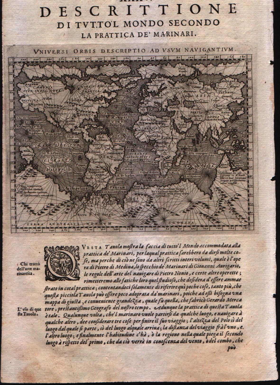
Map title
Universi Orbis Descriptio ad usum navigantium.
Author
Magini
Location shown in map
World
Edition date
1598
Edition place
Venice
Editor
Battista & Giorgio Galignani
Atlas
Geografia di Claudio Tolomeo -- Giovanni Antonio Magini
Price
700 Euro
State
[MINT/excellent/very good/good/fair/mediocre/poor]
Color
Black/white
Verso
Italian text pag.211
Size
Plate: cm (17.8 x 12.7) inches (7.01 x 5) Paper: cm (20.3 x 30.5) inches (7.99 x 12.01)
Technique
Copper engraving
Note
--
Reference
--
Wiki
Here for more info
In stock
Available
Info
info@thetreasuremaps.com
Code
#0336
×
![Universi Orbis Descriptio ad usum navigantium. by Magini, World, 1598]()
Map title
Orbis descriptio
Author
Ruscelli
Location shown in map
World
Edition date
1599
Edition place
Venice
Editor
Rosaccio
Atlas
La Geographia di Claudio Tolomeo
Price
700 Euro
State
[mint/EXCELLENT/very good/good/fair/mediocre/poor]
Color
Black/white
Verso
Italian text pag.10
Size
Plate: cm (25.4 x 17.8) inches (10 x 7.01) Paper: cm (35.6 x 24.1) inches (14.02 x 9.49)
Technique
Copper engraving
Note
This later edition has been altered to show the Southern Continent.
Reference
--
Wiki
Here for more info
In stock
Available
Info
info@thetreasuremaps.com
Code
#0333
×
![Orbis descriptio by Ruscelli, World, 1599]()
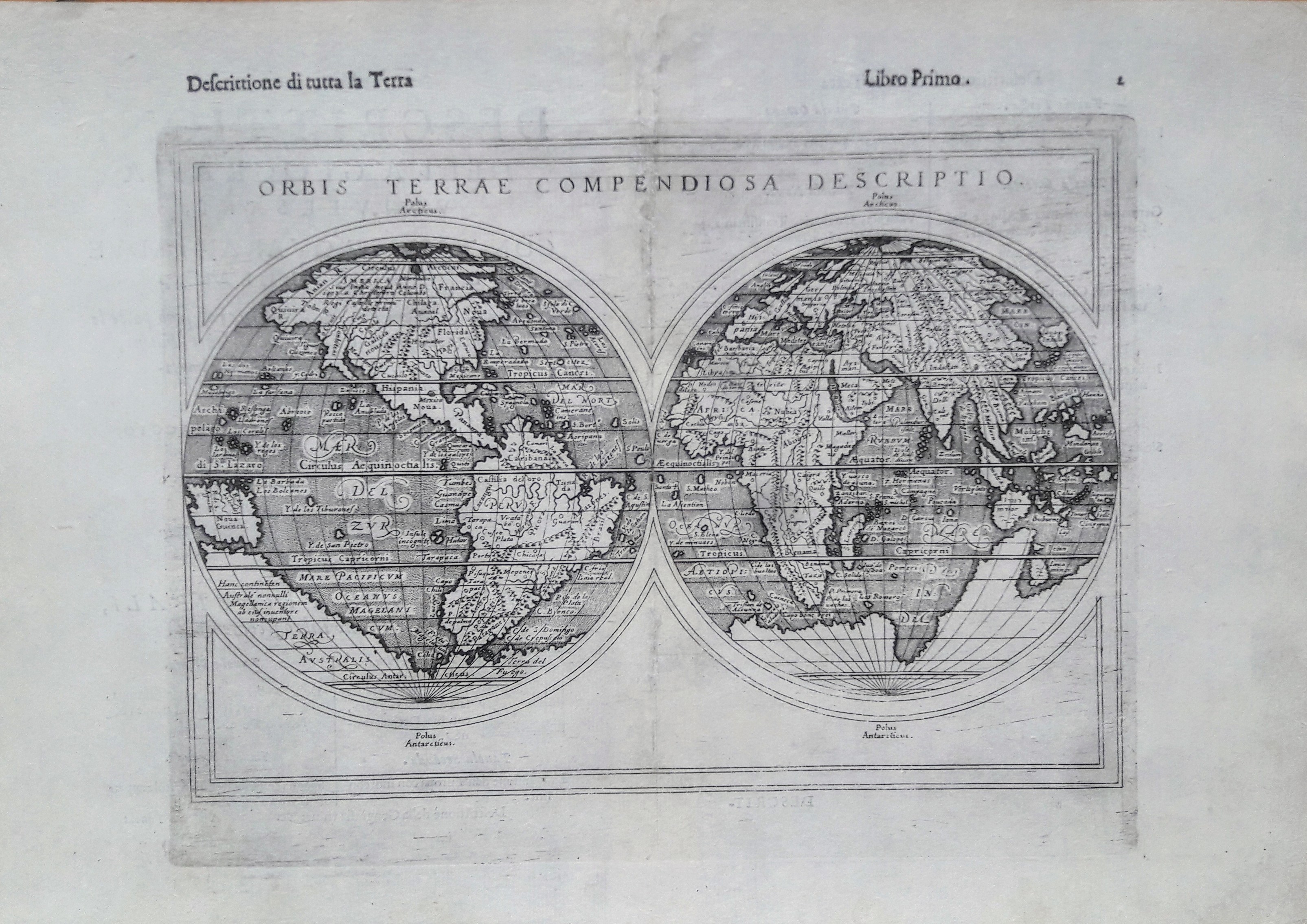
Map title
Orbis terrae compendiosa descriptio
Author
Ruscelli
Location shown in map
World
Edition date
1599
Edition place
Venice
Editor
Rosaccio
Atlas
La Geographia di Claudio Tolomeo
Price
1100 Euro
State
[mint/EXCELLENT/very good/good/fair/mediocre/poor]
Color
Black/white
Verso
Italian text pag.2
Size
Plate: cm (25.4 x 17.8) inches (10 x 7.01) Paper: cm (35.6 x 24.1) inches (14.02 x 9.49)
Technique
Copper engraving
Note
Later edition.
Reference
--
Wiki
Here for more info
In stock
Available
Info
info@thetreasuremaps.com
Code
#0334
×
![Orbis terrae compendiosa descriptio by Ruscelli, World, 1599]()
Map title
Typus orbis terrarum
Author
Doglioni
Location shown in map
World
Edition date
1623
Edition place
Venice
Editor
Giacomo Sarzina
Atlas
Anfiteatro di Europa
Price
Please ask: info@thetreasuremaps.com
State
[MINT/excellent/very good/good/fair/mediocre/poor]
Color
Black/white
Verso
Italian text pag.94
Size
Plate: cm (11.4 x 8.9) inches (4.49 x 3.5) Paper: cm (15.2 x 22.9) inches (5.98 x 9.02)
Technique
Copper engraving
Note
The maps are copies of the Galle (c.1595) edition of Ortelius.
Reference
--
Wiki
Here for more info
In stock
Sold
Info
info@thetreasuremaps.com
Code
#0558
×
![Typus orbis terrarum by Doglioni, World, 1623]()
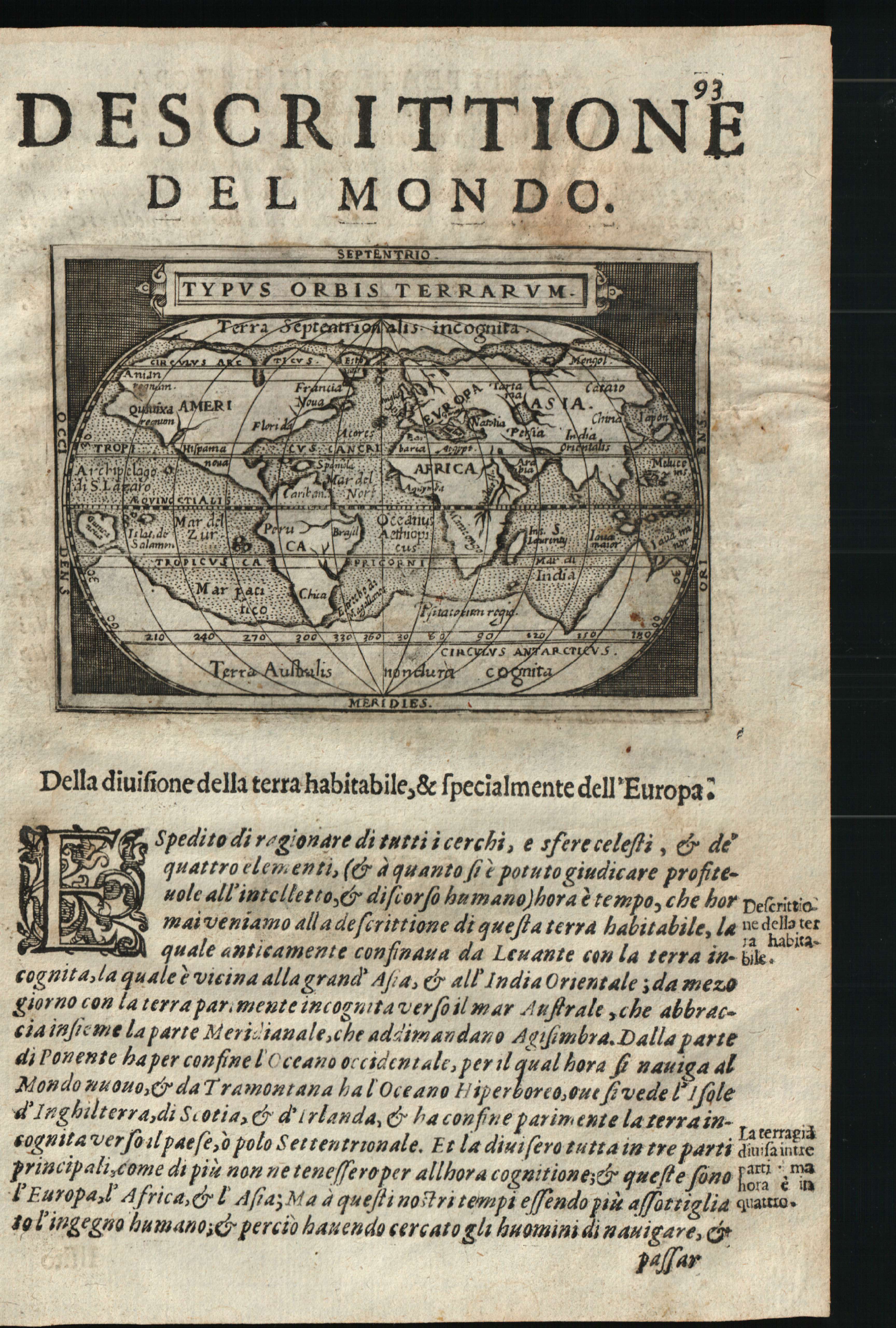
Map title
Descrittione del mondo
Author
Doglioni
Location shown in map
World
Edition date
1623
Edition place
Venice
Editor
Giacomo Sarzina
Atlas
Anfiteatro di Europa
Price
600 Euro
State
[mint/EXCELLENT/very good/good/fair/mediocre/poor]
Color
Black/white
Verso
Italian text pag.94
Size
Plate: cm (11.4 x 8.9) inches (4.49 x 3.5) Paper: cm (15.2 x 22.9) inches (5.98 x 9.02)
Technique
Copper engraving
Note
The maps are copies of the Galle (c.1595) edition of Ortelius.
Reference
--
Wiki
Here for more info
In stock
Available
Info
info@thetreasuremaps.com
Code
#0602
×
![Descrittione del mondo by Doglioni, World, 1623]()
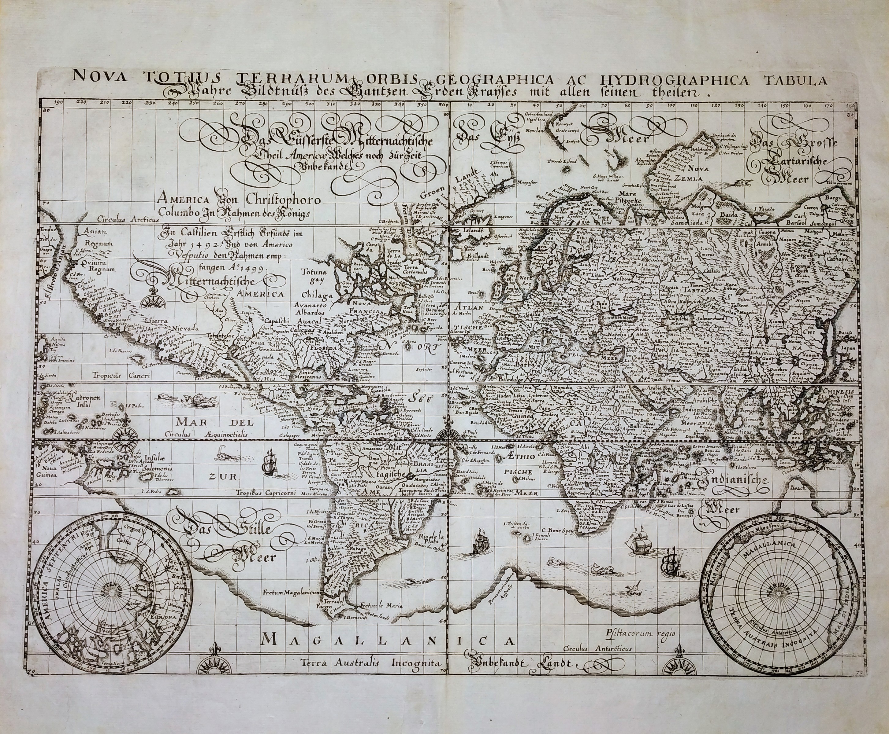
Map title
Nova Totius Terrarum Orbis Geographica ac Hydrographica Tabula
Author
Merian
Location shown in map
World
Edition date
Circa 1646
Edition place
Frankfurt
Editor
--
Atlas
Neuwe Archontologia Cosmica
Price
1000 Euro
State
[MINT/excellent/very good/good/fair/mediocre/poor]
Color
Black/white
Verso
Blank
Size
Plate: cm (35 x 26) inches (13.78 x 10.24) Paper: cm (39 x 33) inches (15.35 x 12.99)
Technique
Copper engraving
Note
No particular notes for this maps.
Reference
--
Wiki
Here for more info
In stock
Available
Info
info@thetreasuremaps.com
Code
#0705
×
![Nova Totius Terrarum Orbis Geographica ac Hydrographica Tabula by Merian, World, Circa 1646]()
Map title
Orbis Terrarum Veteribus Cogniti Typus Geographicus
Author
Jansson
Location shown in map
World
Edition date
Circa 1650
Edition place
Amsterdam
Editor
Janssonius
Atlas
Atlas
Price
600 Euro
State
[mint/EXCELLENT/verygood/good/fair/mediocre/poor]
Color
Old colors
Verso
Latin
Size
Plate: cm (49.5 x 39.4) inches (19.49 x 15.51) Paper: cm (58.4 x 48.3) inches (22.99 x 19.02)
Technique
Copper engraving
Note
--
Reference
--
Wiki
Here for more info
In stock
Available
Info
info@thetreasuremaps.com
Code
#0599
×
![Orbis Terrarum Veteribus Cogniti Typus Geographicus by Jansson, World, Circa 1650]()
Map title
Tabula geographico-hydrographica motus oceani currentes abyssos montes ...
Author
Kircher
Location shown in map
World
Edition date
1678
Edition place
Amsterdam
Editor
Jansson
Atlas
Mundus subterraneus
Price
1100 Euro
State
[mint/EXCELLENT/very good/good/fair/mediocre/poor]
Color
Modern color
Verso
Blank
Size
Plate: cm (54 x 34) inches (21.26 x 13.39) Paper: cm (57 x 39) inches (22.44 x 15.35)
Technique
Copper engraving
Note
Reference
Wiki
Here for more info
In stock
Available
Info
info@thetreasuremaps.com
Code
#0788
×
![Tabula geographico-hydrographica motus oceani currentes abyssos montes ... by Kircher, World, 1678]()
Map title
Orbis Terrarum typus
Author
Location shown in map
World
Edition date
Circa 1700
Edition place
Editor
--
Atlas
Price
175 Euro
State
[mint/excellent/VERY GOOD/good/fair/mediocre/poor]
Color
Black/white
Verso
Blank
Size
Plate: cm (25 x 14.5) inches (9.84 x 5.71) Paper: cm (27 x 17) inches (10.63 x 6.69)
Technique
Copper engraving
Note
Reference
--
Wiki
Here for more info
In stock
Available
Info
info@thetreasuremaps.com
Code
#0998
×
![Orbis Terrarum typus by , World, Circa 1700]()
Map title
Mappamondo
Author
Unknown
Location shown in map
World
Edition date
1720
Edition place
--
Editor
--
Atlas
--
Price
100 Euro
State
[mint/EXCELLENT/very good/good/fair/mediocre/poor]
Color
Black/white
Verso
Size
Plate: cm (17.8 x 14) inches (7.01 x 5.51) Paper: cm (20.3 x 15.2) inches (7.99 x 5.98)
Technique
Copper engraving
Note
--
Reference
--
Wiki
Here for more info
In stock
Available
Info
info@thetreasuremaps.com
Code
#0337
×
![Mappamondo by Unknown, World, 1720]()