Bellin
Map title
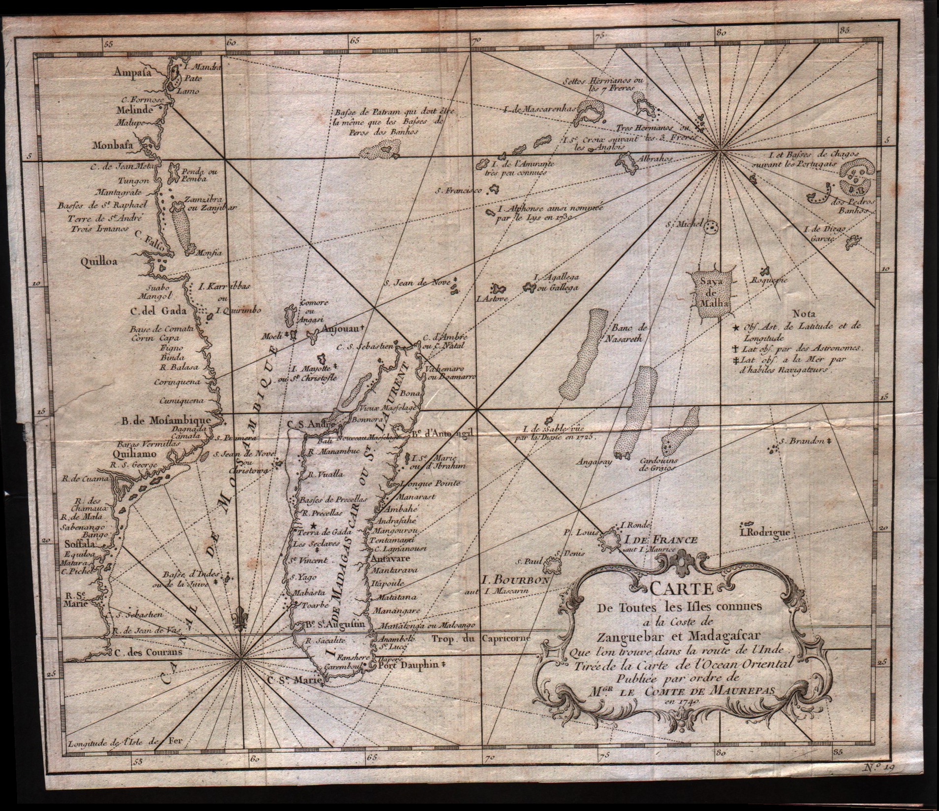
Carte de toutes les isles connues a la coste de Zanguebar at Madagascar
Author
Bellin
Location shown in map
--
Edition date
1757
Edition place
Paris
Editor
--
Atlas
Historie General des Voyages -- Prevost
Price
150 Euro
State
[mint/excellent/very good/GOOD/fair/mediocre/poor]
Color
Black/white
Verso
Blank
Size
Plate: cm (27.9 x 24.1) inches (10.98 x 9.49) Paper: cm (29.2 x 25.4) inches (11.5 x 10)
Technique
Copper engraving
Note
No particular notes for this maps
Reference
--
Wiki
Here for more info
In stock
Available
Info
info@thetreasuremaps.com
Code
#0305
×
![Carte de toutes les isles connues a la coste de Zanguebar at Madagascar by Bellin, --, 1757]()
Map title
Carte Des Royaumes De Congo Angola Et Benguela
Author
Bellin
Location shown in map
--
Edition date
1757
Edition place
Paris
Editor
--
Atlas
Historie General des Voyages -- Prevost
Price
Please ask: info@thetreasuremaps.com
State
[mint/excellent/very good/GOOD/fair/mediocre/poor]
Color
Black/white
Verso
Blank
Size
Plate: cm (30.5 x 24.1) inches (12.01 x 9.49) Paper: cm (33 x 25.4) inches (12.99 x 10)
Technique
Copper engraving
Note
No particular notes for this maps
Reference
--
Wiki
Here for more info
In stock
Available
Info
info@thetreasuremaps.com
Code
#0304
×
![Carte Des Royaumes De Congo Angola Et Benguela by Bellin, --, 1757]()
Map title
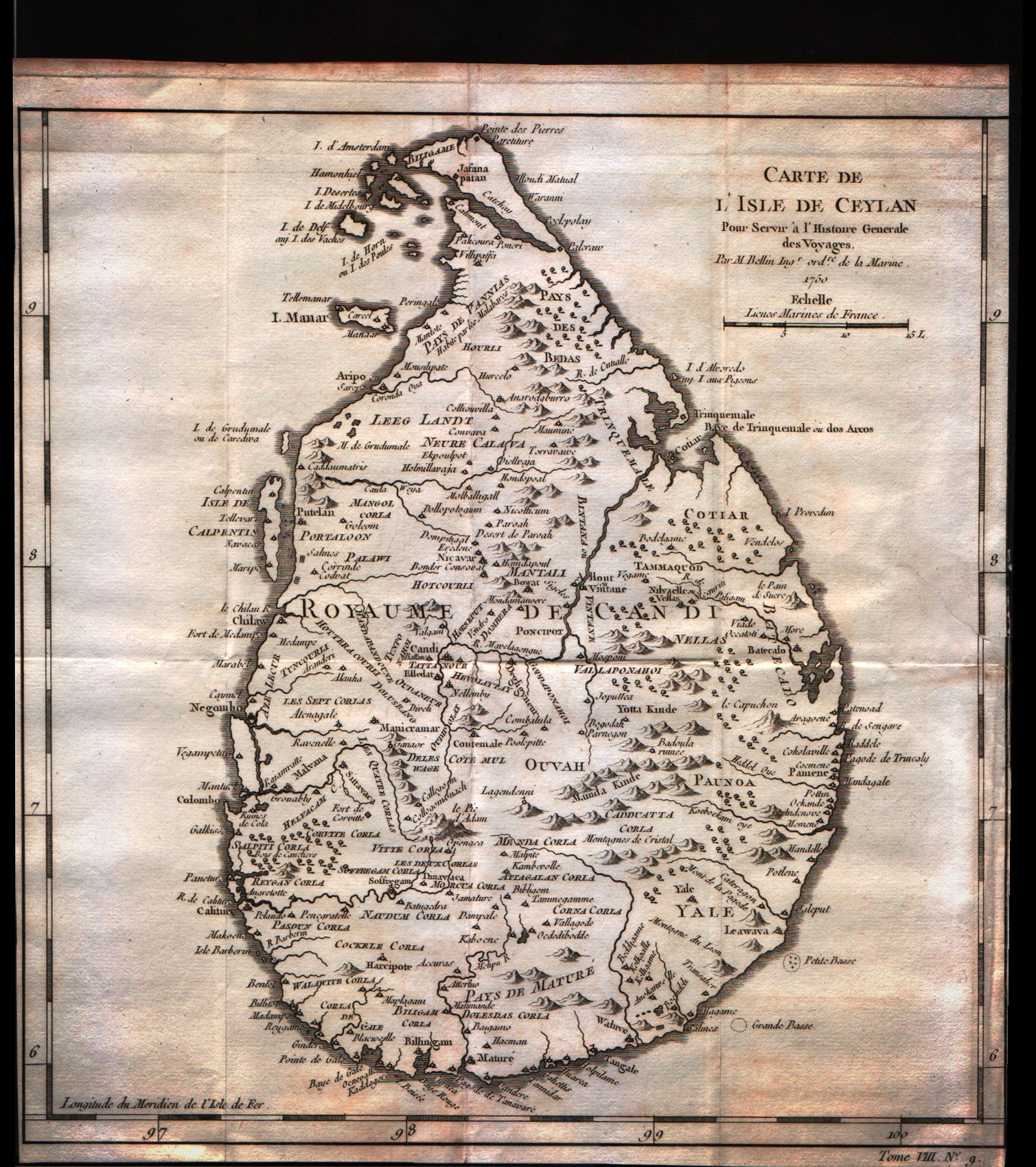
Carte de l'isle de Ceylan
Author
Bellin
Location shown in map
Ceylan islands
Edition date
1757
Edition place
Paris
Editor
--
Atlas
Historie General des Voyages -- Prevost
Price
125 Euro
State
[mint/excellent/very good/GOOD/fair/mediocre/poor]
Color
Black/white
Verso
Blank
Size
Plate: cm (24.1 x 25.4) inches (9.49 x 10) Paper: cm (24.1 x 25.4) inches (9.49 x 10)
Technique
Copper engraving
Note
No particular notes for this maps
Reference
--
Wiki
Here for more info
In stock
Available
Info
info@thetreasuremaps.com
Code
#0252
×
![Carte de l'isle de Ceylan by Bellin, Ceylan islands, 1757]()
Map title
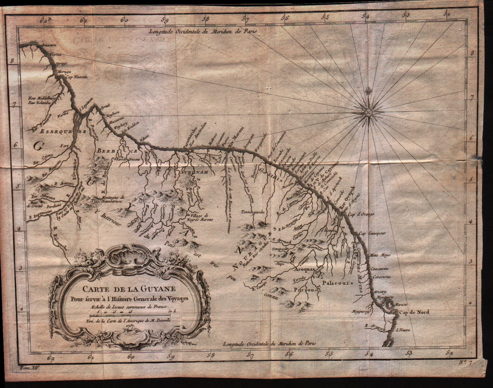
Carte de la Guyane
Author
Bellin
Location shown in map
Guyane
Edition date
1757
Edition place
Paris
Editor
--
Atlas
Historie General des Voyages -- Prevost
Price
Please ask: info@thetreasuremaps.com
State
[mint/EXCELLENT/very good/good/fair/mediocre/poor]
Color
Black/white
Verso
Blank
Size
Plate: cm (30.5 x 22.9) inches (12.01 x 9.02) Paper: cm (33 x 25.4) inches (12.99 x 10)
Technique
Copper engraving
Note
No particular notes for this maps
Reference
--
Wiki
Here for more info
In stock
Available
Info
info@thetreasuremaps.com
Code
#0021
×
![Carte de la Guyane by Bellin, Guyane, 1757]()
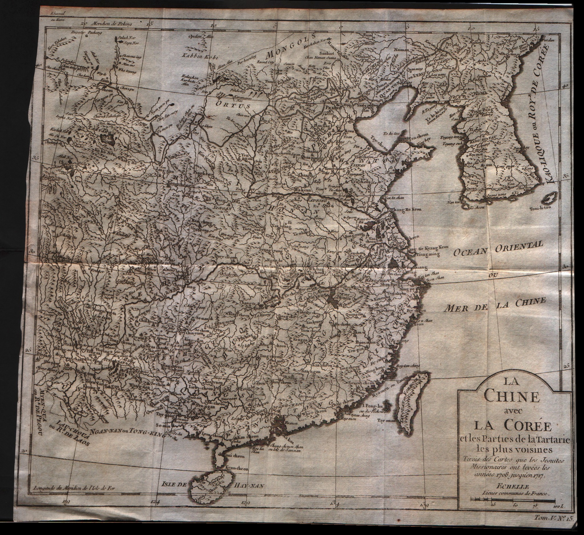
Map title
La Chine avec la Coree et les parties de la Tartarie les plus voisines
Author
Bellin
Location shown in map
China
Edition date
1757
Edition place
Paris
Editor
--
Atlas
Historie General des Voyages -- Prevost
Price
250 Euro
State
[mint/excellent/VERY GOOD/good/fair/mediocre/poor]
Color
Black/white
Verso
Blank
Size
Plate: cm (31.8 x 27.9) inches (12.52 x 10.98) Paper: cm (31.8 x 29.8) inches (12.52 x 11.73)
Technique
Copper engraving
Note
No particular notes for this maps
Reference
--
Wiki
Here for more info
In stock
Available
Info
info@thetreasuremaps.com
Code
#0243
×
![La Chine avec la Coree et les parties de la Tartarie les plus voisines by Bellin, China, 1757]()
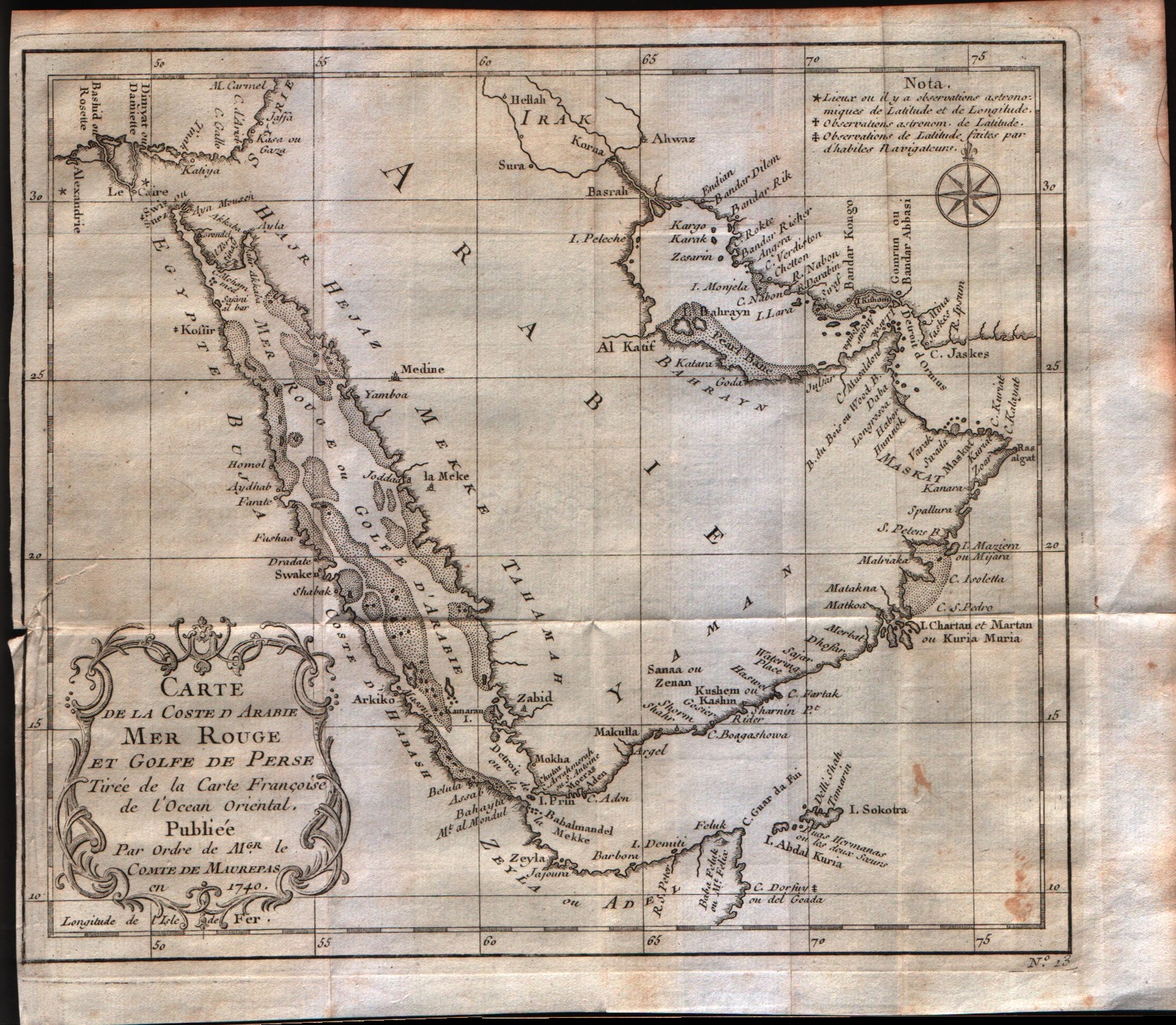
Map title
Carte de la coste d'Arabie Mer Rouge et Golfe de Perse
Author
Bellin
Location shown in map
Arabia
Edition date
1757
Edition place
Paris
Editor
--
Atlas
Historie General des Voyages -- Prevost
Price
300 Euro
State
[mint/excellent/VERY GOOD/good/fair/mediocre/poor]
Color
Black/white
Verso
Blank
Size
Plate: cm (25.4 x 21.6) inches (10 x 8.5) Paper: cm (27.9 x 24.1) inches (10.98 x 9.49)
Technique
Copper engraving
Note
No particular notes for this maps
Reference
--
Wiki
Here for more info
In stock
Available
Info
info@thetreasuremaps.com
Code
#0244
×
![Carte de la coste d'Arabie Mer Rouge et Golfe de Perse by Bellin, Arabia, 1757]()

Map title
Carte de l'entree de la riviere de Canton
Author
Bellin
Location shown in map
--
Edition date
1757
Edition place
Paris
Editor
--
Atlas
Historie General des Voyages -- Prevost
Price
Please ask: info@thetreasuremaps.com
State
[mint/excellent/VERY GOOD/good/fair/mediocre/poor]
Color
Black/white
Verso
Blank
Size
Plate: cm (20.3 x 25.4) inches (7.99 x 10) Paper: cm (21.6 x 26.7) inches (8.5 x 10.51)
Technique
Copper engraving
Note
No particular notes for this maps
Reference
--
Wiki
Here for more info
In stock
Sold
Info
info@thetreasuremaps.com
Code
#0245
×
![Carte de l'entree de la riviere de Canton by Bellin, --, 1757]()
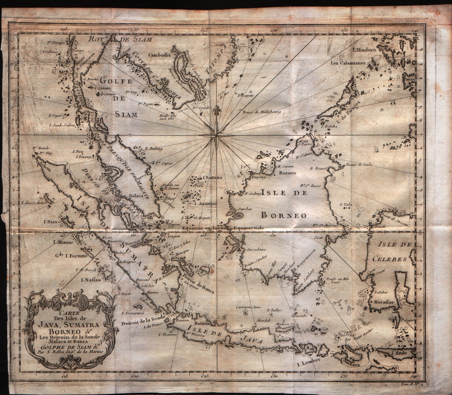
Map title
Carte Des Isles De Java, Sumatra Borneo
Author
Bellin
Location shown in map
Java Sumatra
Edition date
1757
Edition place
Paris
Editor
--
Atlas
Historie General des Voyages -- Prevost
Price
200 Euro
State
[mint/excellent/VERY GOOD/good/fair/mediocre/poor]
Color
Black/white
Verso
Blank
Size
Plate: cm (29.2 x 24.1) inches (11.5 x 9.49) Paper: cm (30.5 x 26.7) inches (12.01 x 10.51)
Technique
Copper engraving
Note
No particular notes for this maps
Reference
--
Wiki
Here for more info
In stock
Available
Info
info@thetreasuremaps.com
Code
#0247
×
![Carte Des Isles De Java, Sumatra Borneo by Bellin, Java Sumatra, 1757]()
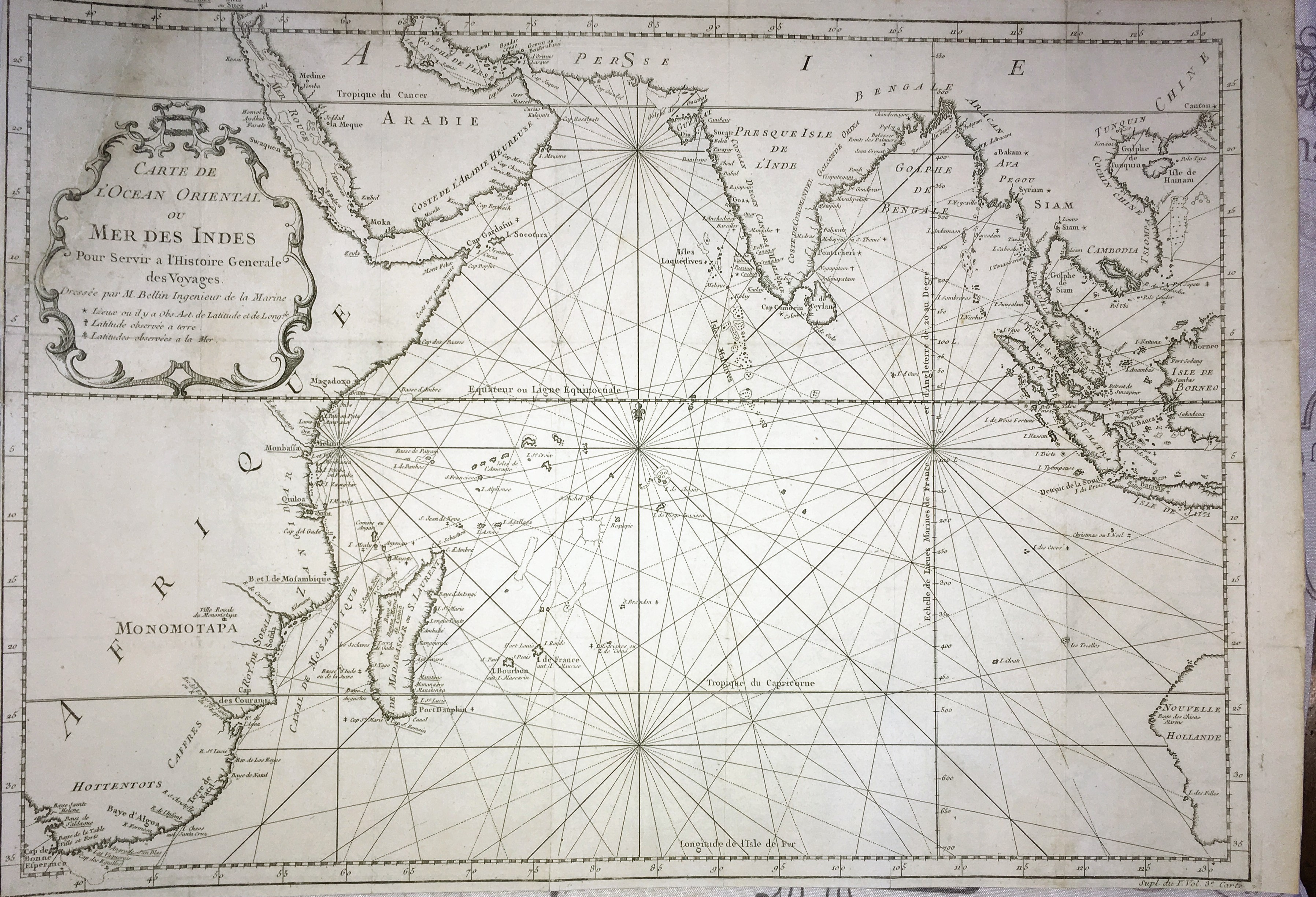
Map title
Carte de l'ocean Oriental ou mer des Indes
Author
Bellin
Location shown in map
--
Edition date
1757
Edition place
Paris
Editor
--
Atlas
Historie General des Voyages -- Prevost
Price
250 Euro
State
[mint/excellent/very good/good/FAIR/mediocre/poor] The map has been repaired. The upper left corner was cut off.
Color
Black/white
Verso
Blank
Size
Plate: cm (48.3 x 34.3) inches (19.02 x 13.5) Paper: cm (49.5 x 35.6) inches (19.49 x 14.02)
Technique
Copper engraving
Note
Large maritime map of the Indian Ocean. Coastal data is shown on the land masses of Africa, Arabian Peninsula, India, Indonesia and part of Australia.
Reference
--
Wiki
Here for more info
In stock
Available
Info
info@thetreasuremaps.com
Code
#0248
×
![Carte de l'ocean Oriental ou mer des Indes by Bellin, --, 1757]()
Map title
Carte De L'Empire Du Japon
Author
Bellin
Location shown in map
Japan
Edition date
1757
Edition place
Paris
Editor
--
Atlas
Historie General des Voyages -- Prevost
Price
Please ask: info@thetreasuremaps.com
State
[mint/excellent/VERY GOOD/good/fair/mediocre/poor]
Color
Black/white
Verso
Blank
Size
Plate: cm (31.1 x 21.6) inches (12.24 x 8.5) Paper: cm (31.1 x 22.9) inches (12.24 x 9.02)
Technique
Copper engraving
Note
No particular notes for this maps
Reference
--
Wiki
Here for more info
In stock
Sold
Info
info@thetreasuremaps.com
Code
#0249
×
![Carte De L'Empire Du Japon by Bellin, Japan, 1757]()
Map title
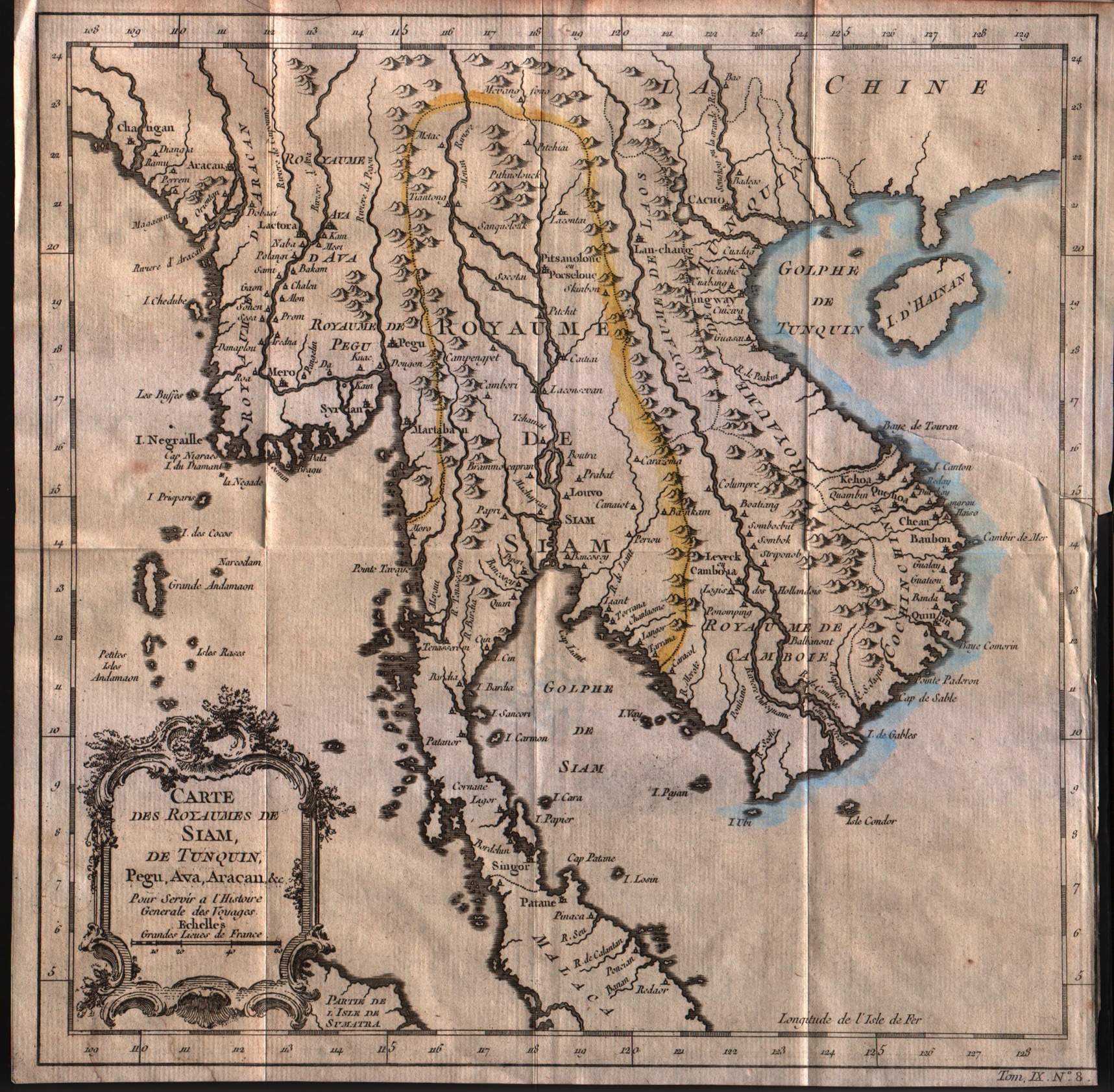
Carte des royaumes de Siam de Tunquin, Pegu, Ava, Aracan
Author
Bellin
Location shown in map
--
Edition date
1757
Edition place
Paris
Editor
--
Atlas
Historie General des Voyages -- Prevost
Price
Please ask: info@thetreasuremaps.com
State
[mint/excellent/very good/GOOD/fair/mediocre/poor]
Color
Black/white
Verso
Blank
Size
Plate: cm (27.9 x 27.9) inches (10.98 x 10.98) Paper: cm (28.6 x 28.6) inches (11.26 x 11.26)
Technique
Copper engraving
Note
No particular notes for this maps
Reference
--
Wiki
Here for more info
In stock
Available
Info
info@thetreasuremaps.com
Code
#0250
×
![Carte des royaumes de Siam de Tunquin, Pegu, Ava, Aracan by Bellin, --, 1757]()
Map title
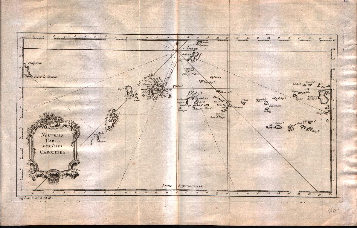
Nouvelle carte des isles Carolines
Author
Bellin
Location shown in map
Caroline islands
Edition date
1757
Edition place
Paris
Editor
--
Atlas
Historie General des Voyages -- Prevost
Price
125 Euro
State
[mint/EXCELLENT/very good/good/fair/mediocre/poor]
Color
Black/white
Verso
Blank
Size
Plate: cm (38.1 x 20.3) inches (15 x 7.99) Paper: cm (43.2 x 27.9) inches (17.01 x 10.98)
Technique
Copper engraving
Note
No particular notes for this maps
Reference
--
Wiki
Here for more info
In stock
Available
Info
info@thetreasuremaps.com
Code
#0251
×
![Nouvelle carte des isles Carolines by Bellin, Caroline islands, 1757]()
Map title
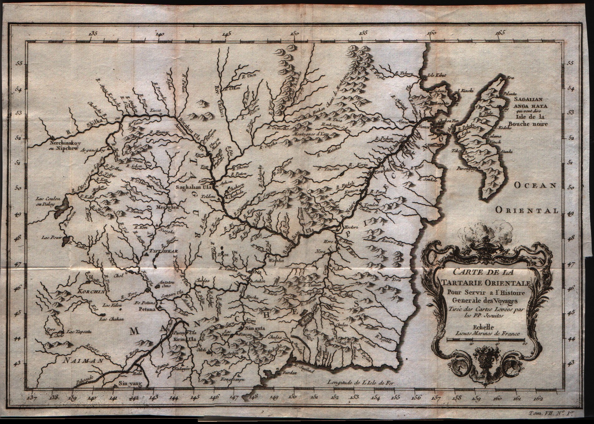
Carte de la Tartarie Orientale
Author
Bellin
Location shown in map
North-east China
Edition date
1757
Edition place
Paris
Editor
--
Atlas
Historie General des Voyages -- Prevost
Price
75 Euro
State
[mint/EXCELLENT/very good/good/fair/mediocre/poor]
Color
Black/white
Verso
Blank
Size
Plate: cm (30.5 x 20.3) inches (12.01 x 7.99) Paper: cm (30.5 x 22.9) inches (12.01 x 9.02)
Technique
Copper engraving
Note
No particular notes for this maps
Reference
--
Wiki
Here for more info
In stock
Available
Info
info@thetreasuremaps.com
Code
#0257
×
![Carte de la Tartarie Orientale by Bellin, North-east China, 1757]()
Map title
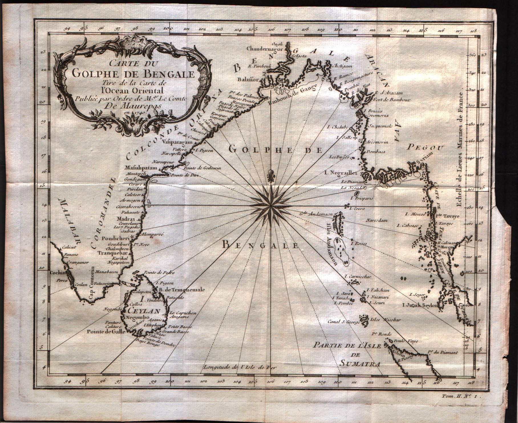
Carte du Golphe de Bengale
Author
Bellin
Location shown in map
--
Edition date
1757
Edition place
Paris
Editor
--
Atlas
Historie General des Voyages -- Prevost
Price
150 Euro
State
[mint/excellent/VERY GOOD/good/fair/mediocre/poor]
Color
Black/white
Verso
Blank
Size
Plate: cm (26.7 x 22.9) inches (10.51 x 9.02) Paper: cm (29.8 x 24.8) inches (11.73 x 9.76)
Technique
Copper engraving
Note
No particular notes for this maps
Reference
--
Wiki
Here for more info
In stock
Available
Info
info@thetreasuremaps.com
Code
#0242
×
![Carte du Golphe de Bengale by Bellin, --, 1757]()
Map title
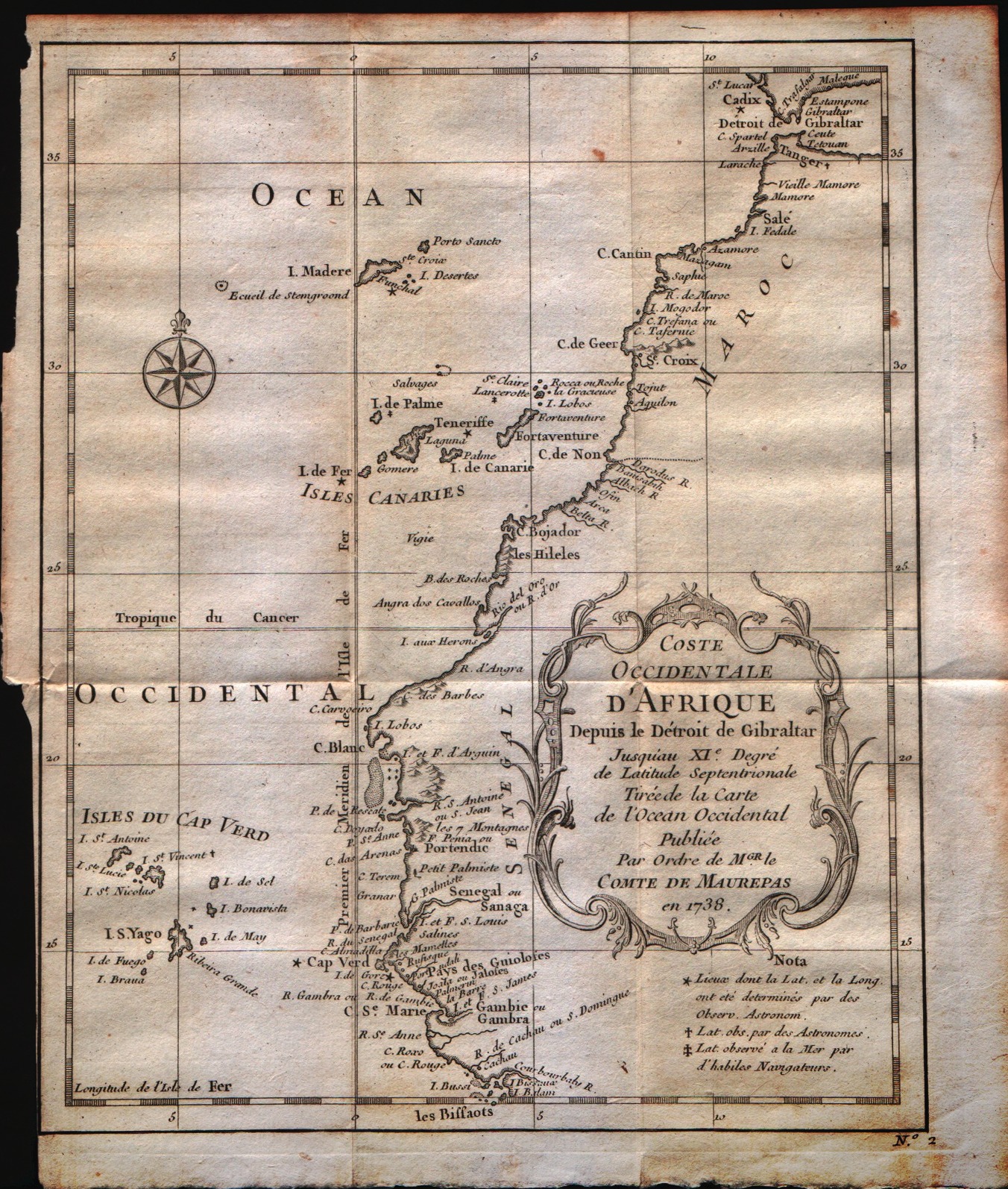
Coste occidentale d'Afrique
Author
Bellin
Location shown in map
--
Edition date
1757
Edition place
Paris
Editor
--
Atlas
Historie General des Voyages -- Prevost
Price
Please ask: info@thetreasuremaps.com
State
[mint/EXCELLENT/very good/good/fair/mediocre/poor]
Color
Black/white
Verso
Blank
Size
Plate: cm (25.4 x 24.1) inches (10 x 9.49) Paper: cm (27.9 x 25.4) inches (10.98 x 10)
Technique
Copper engraving
Note
No particular notes for this maps
Reference
--
Wiki
Here for more info
In stock
Available
Info
info@thetreasuremaps.com
Code
#0301
×
![Coste occidentale d'Afrique by Bellin, --, 1757]()
Map title
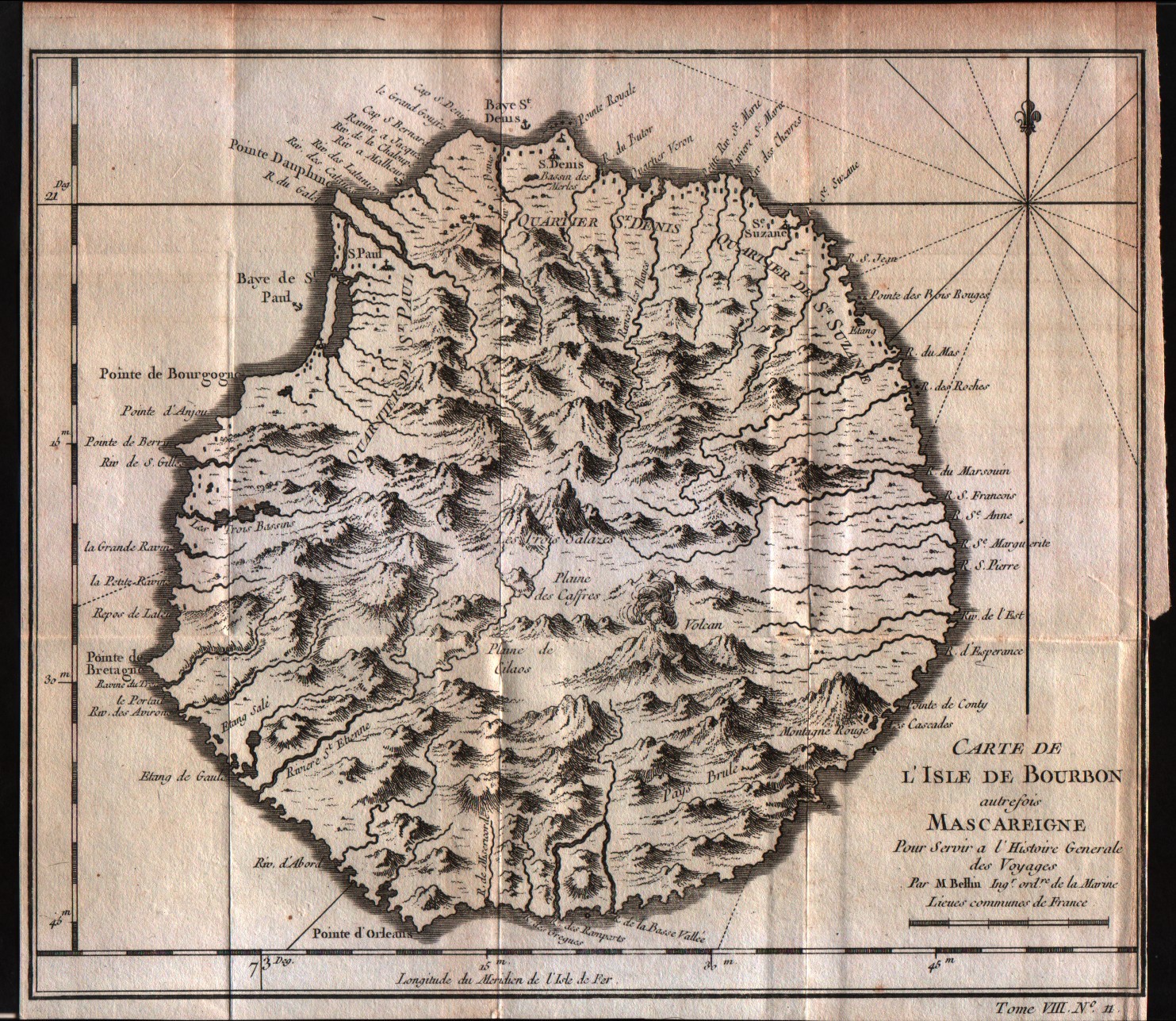
Carte de l'isle de Bourbon
Author
Bellin
Location shown in map
Reunion
Edition date
1757
Edition place
Paris
Editor
--
Atlas
Historie General des Voyages -- Prevost
Price
75 Euro
State
[mint/EXCELLENT/very good/good/fair/mediocre/poor]
Color
Black/white
Verso
Blank
Size
Plate: cm (24.1 x 20.3) inches (9.49 x 7.99) Paper: cm (24.1 x 21.6) inches (9.49 x 8.5)
Technique
Copper engraving
Note
No particular notes for this maps
Reference
--
Wiki
Here for more info
In stock
Available
Info
info@thetreasuremaps.com
Code
#0300
×
![Carte de l'isle de Bourbon by Bellin, Reunion, 1757]()
Map title
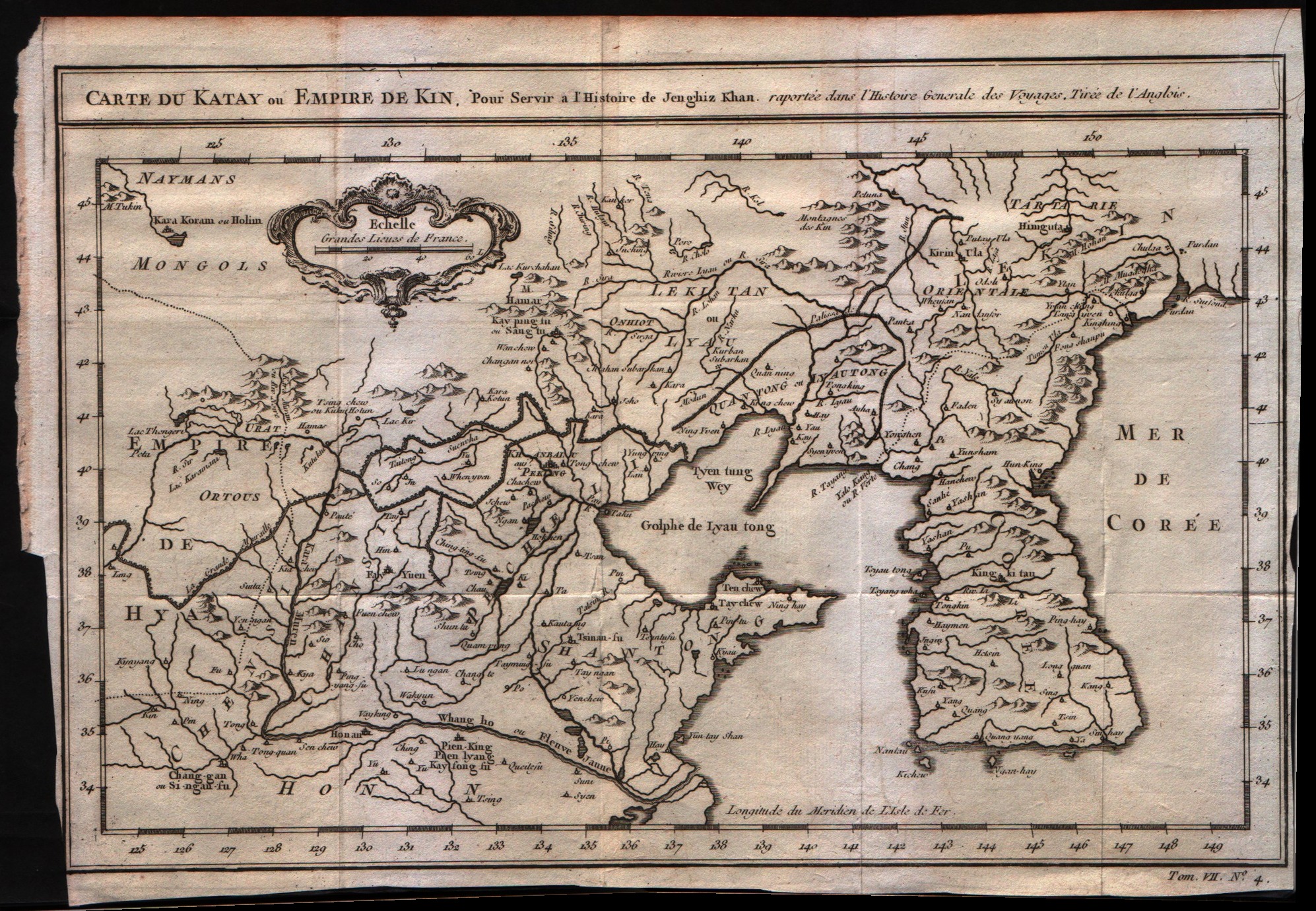
Carte du Katay ou Empere de Kin
Author
Bellin
Location shown in map
--
Edition date
1757
Edition place
Paris
Editor
--
Atlas
Historie General des Voyages -- Prevost
Price
250 Euro
State
[mint/EXCELLENT/very good/good/fair/mediocre/poor]
Color
Black/white
Verso
Blank
Size
Plate: cm (30.5 x 21.6) inches (12.01 x 8.5) Paper: cm (33 x 22.9) inches (12.99 x 9.02)
Technique
Copper engraving
Note
No particular notes for this maps
Reference
--
Wiki
Here for more info
In stock
Available
Info
info@thetreasuremaps.com
Code
#0258
×
![Carte du Katay ou Empere de Kin by Bellin, --, 1757]()
Map title
Carte des costes de Cochin Chine Tunquin et partie de celles de la Chine
Author
Bellin
Location shown in map
Cochin Coast and the coast of Tunquin.
Edition date
1757
Edition place
Paris
Editor
--
Atlas
Historie General des Voyages -- Prevost
Price
Please ask: info@thetreasuremaps.com
State
[mint/EXCELLENT/very good/good/fair/mediocre/poor]
Color
Black/white
Verso
Blank
Size
Plate: cm (14 x 21.6) inches (5.51 x 8.5) Paper: cm (20.3 x 27.9) inches (7.99 x 10.98)
Technique
Copper engraving
Note
No particular notes for this maps
Reference
--
Wiki
Here for more info
In stock
Sold
Info
info@thetreasuremaps.com
Code
#0255
×
![Carte des costes de Cochin Chine Tunquin et partie de celles de la Chine by Bellin, Cochin Coast and the coast of Tunquin., 1757]()
Map title
Carte de l'isle de Ceylan
Author
Bellin
Location shown in map
Ceylan islands
Edition date
1757
Edition place
Paris
Editor
--
Atlas
Historie General des Voyages -- Prevost
Price
125 Euro
State
[mint/excellent/very good/GOOD/fair/mediocre/poor]
Color
Black/white
Verso
Blank
Size
Plate: cm (24.1 x 25.4) inches (9.49 x 10) Paper: cm (24.1 x 26.7) inches (9.49 x 10.51)
Technique
Copper engraving
Note
No particular notes for this maps
Reference
--
Wiki
Here for more info
In stock
Sold
Info
info@thetreasuremaps.com
Code
#0253
×
![Carte de l'isle de Ceylan by Bellin, Ceylan islands, 1757]()
Map title
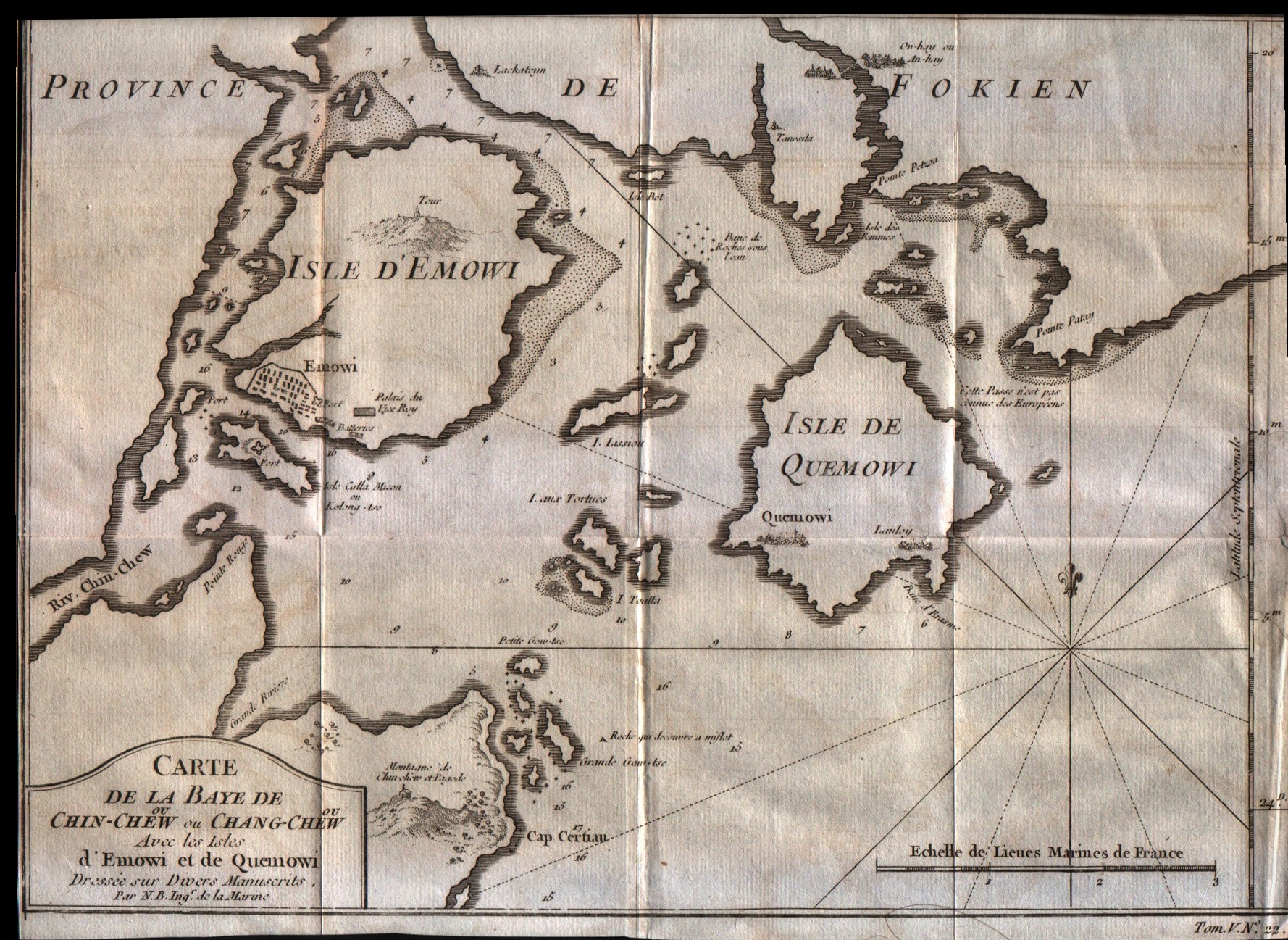
Carte de la Baye de Chin-Chew ou Chang-Chew avec les isles d'Emowi et de Quemowi
Author
Bellin
Location shown in map
Fukien centred on the islands of Amoy & Quemoy.
Edition date
1757
Edition place
Paris
Editor
--
Atlas
Historie General des Voyages -- Prevost
Price
100 Euro
State
[mint/EXCELLENT/very good/good/fair/mediocre/poor]
Color
Black/white
Verso
Blank
Size
Plate: cm (30.5 x 20.3) inches (12.01 x 7.99) Paper: cm (38.1 x 27.9) inches (15 x 10.98)
Technique
Copper engraving
Note
No particular notes for this maps
Reference
--
Wiki
Here for more info
In stock
Available
Info
info@thetreasuremaps.com
Code
#0254
×
![Carte de la Baye de Chin-Chew ou Chang-Chew avec les isles d'Emowi et de Quemowi by Bellin, Fukien centred on the islands of Amoy & Quemoy., 1757]()