Bonne
Pages: 1 2
Map title
Isles de la Reine Charlotte
Author
Bonne
Location shown in map
Canada
Edition date
1776
Edition place
Paris
Editor
Lattre
Atlas
Atlas Moderne
Price
100 Euro
State
[mint/EXCELLENT/very good/good/fair/mediocre/poor]
Color
Black/white
Verso
Blank
Size
Plate: cm (35 x 24) inches (13.78 x 9.45) Paper: cm (41 x 28) inches (16.14 x 11.02)
Technique
Copper engraving
Note
Reference
--
Wiki
Here for more info
In stock
Available
Info
info@thetreasuremaps.com
Code
#1375
×
![Isles de la Reine Charlotte by Bonne, Canada, 1776]()
Map title
L'Empire de la Chine d'Apres L'Atlas Chinois avec Les Isles du Japon
Author
Bonne
Location shown in map
China
Edition date
1776
Edition place
Paris
Editor
Lattre
Atlas
Atlas Moderne
Price
125 Euro
State
[mint/EXCELLENT/very good/good/fair/mediocre/poor]
Color
Old colors
Verso
Blank
Size
Plate: cm (46 x 32) inches (18.11 x 12.6) Paper: cm (52 x 38) inches (20.47 x 14.96)
Technique
Copper engraving
Note
Reference
--
Wiki
Here for more info
In stock
Available
Info
info@thetreasuremaps.com
Code
#1088
×
![L'Empire de la Chine d'Apres L'Atlas Chinois avec Les Isles du Japon by Bonne, China, 1776]()
Map title
Planisphere suivant la projection de Mercator
Author
Bonne
Location shown in map
World
Edition date
1780
Edition place
Paris
Editor
--
Atlas
Atlas de toutes les parties connues du globe terrestre : dresse pour l'histoire philosophique et politique des alissemens et du commerce des europens dans les deux Indes. J.L.Pellet
Price
150 Euro
State
[mint/excellent/VERY GOOD/good/fair/mediocre/poor]
Color
Black/white
Verso
Blank
Size
Plate: cm (31.8 x 21) inches (12.52 x 8.27) Paper: cm (41.9 x 26.7) inches (16.5 x 10.51)
Technique
Copper engraving
Note
No particular notes for this maps
Reference
--
Wiki
Here for more info
In stock
Available
Info
info@thetreasuremaps.com
Code
#0582
×
![Planisphere suivant la projection de Mercator by Bonne, World, 1780]()

Map title
Les isles Philippines...
Author
Bonne
Location shown in map
South East
Edition date
1780
Edition place
Paris
Editor
--
Atlas
Atlas de toutes les parties connues du globe terrestre. J.L.Pellet
Price
Please ask: info@thetreasuremaps.com
State
[mint/EXCELLENT/very good/good/fair/mediocre/poor]
Color
Black/white
Verso
Blank
Size
Plate: cm (31.8 x 21.6) inches (12.52 x 8.5) Paper: cm (36.8 x 25.4) inches (14.49 x 10)
Technique
Copper engraving
Note
No particular notes for this maps
Reference
--
Wiki
Here for more info
In stock
Sold
Info
info@thetreasuremaps.com
Code
#0439
×
![Les isles Philippines... by Bonne, South East, 1780]()
Map title
L'Europe
Author
Bonne
Location shown in map
Europe
Edition date
1787
Edition place
Paris
Editor
--
Atlas
Atlas Encyclopedique
Price
Please ask: info@thetreasuremaps.com
State
[mint/EXCELLENT/very good/good/fair/mediocre/poor]
Color
Black/white
Verso
Blank
Size
Plate: cm (31.8 x 21) inches (12.52 x 8.27) Paper: cm (35.6 x 25.4) inches (14.02 x 10)
Technique
Copper engraving
Note
--
Reference
--
Wiki
Here for more info
In stock
Available
Info
info@thetreasuremaps.com
Code
#0443
×
![L'Europe by Bonne, Europe, 1787]()
Map title
L'Italie
Author
Bonne
Location shown in map
Italy
Edition date
1787
Edition place
Paris
Editor
Atlas
Atlas Encyclopedique
Price
125 Euro
State
[mint/EXCELLENT/very good/good/fair/mediocre/poor]
Color
Black/white
Verso
Blank
Size
Plate: cm (22 x 35) inches (8.66 x 13.78) Paper: cm (25 x 37) inches (9.84 x 14.57)
Technique
Copper engraving
Note
Reference
Wiki
Here for more info
In stock
Available
Info
info@thetreasuremaps.com
Code
#0931
×
![L'Italie by Bonne, Italy, 1787]()
Map title
Mappemonde
Author
Bonne
Location shown in map
Polar antarctic regions
Edition date
1787
Edition place
Paris
Editor
Atlas
Atlas Encyclopedique
Price
150 Euro
State
[mint/EXCELLENT/very good/good/fair/mediocre/poor]
Color
Old colors
Verso
Blank
Size
Plate: cm (34 x 23) inches (13.39 x 9.06) Paper: cm (47 x 32) inches (18.5 x 12.6)
Technique
Copper engraving
Note
Reference
Wiki
Here for more info
In stock
Available
Info
info@thetreasuremaps.com
Code
#0848
×
![Mappemonde by Bonne, Polar antarctic regions, 1787]()
Map title
Carte De La Partie Sud, Des Etats Unis de L' Amerique Septentrionale
Author
Bonne
Location shown in map
East United States
Edition date
1787
Edition place
Paris
Editor
--
Atlas
Atlas Encyclopedique
Price
175 Euro
State
[mint/EXCELLENT/very good/good/fair/mediocre/poor]
Color
Old colors
Verso
Blank
Size
Plate: cm (31 x 21) inches (12.2 x 8.27) Paper: cm (36 x 25) inches (14.17 x 9.84)
Technique
Copper engraving
Note
No particular notes for this maps
Reference
--
Wiki
Here for more info
In stock
Available
Info
info@thetreasuremaps.com
Code
#0724
×
![Carte De La Partie Sud, Des Etats Unis de L' Amerique Septentrionale by Bonne, East United States, 1787]()
Map title
Carte du Chili depuis le sud du Perou jusqu'au cap Horn
Author
Bonne
Location shown in map
--
Edition date
1787
Edition place
Paris
Editor
--
Atlas
Atlas Encyclopedique
Price
Please ask: info@thetreasuremaps.com
State
[mint/excellent/very good/GOOD/fair/mediocre/poor]
Color
Modern outlined
Verso
Blank
Size
Plate: cm (31.8 x 21) inches (12.52 x 8.27) Paper: cm (31.8 x 21) inches (12.52 x 8.27)
Technique
Copper engraving
Note
No particular notes for this maps
Reference
--
Wiki
Here for more info
In stock
Sold
Info
info@thetreasuremaps.com
Code
#0461
×
![Carte du Chili depuis le sud du Perou jusqu'au cap Horn by Bonne, --, 1787]()
Map title
L'Allemagne, la Boheme et la Hongrie avec une partie de la Pologne
Author
Bonne
Location shown in map
Germany
Edition date
1787
Edition place
Paris
Editor
--
Atlas
Atlas Encyclopedique
Price
Please ask: info@thetreasuremaps.com
State
[mint/excellent/very good/good/FAIR/mediocre/poor]
Color
Modern outlined
Verso
Blank
Size
Plate: cm (31.8 x 21) inches (12.52 x 8.27) Paper: cm (36.8 x 25.4) inches (14.49 x 10)
Technique
Copper engraving
Note
No particular notes for this maps
Reference
--
Wiki
Here for more info
In stock
Available
Info
info@thetreasuremaps.com
Code
#0167
×
![L'Allemagne, la Boheme et la Hongrie avec une partie de la Pologne by Bonne, Germany, 1787]()
Map title
Governament de la Bretagne
Author
Bonne
Location shown in map
--
Edition date
1787
Edition place
Paris
Editor
--
Atlas
Atlas Encyclopedique
Price
Please ask: info@thetreasuremaps.com
State
[mint/excellent/VERY GOOD/good/fair/mediocre/poor]
Color
Black/white
Verso
Blank
Size
Plate: cm (31.8 x 21) inches (12.52 x 8.27) Paper: cm (36.8 x 25.4) inches (14.49 x 10)
Technique
Copper engraving
Note
No particular notes for this maps
Reference
--
Wiki
Here for more info
In stock
Sold
Info
info@thetreasuremaps.com
Code
#0427
×
![Governament de la Bretagne by Bonne, --, 1787]()
Map title
L'Allemagne, la Boheme et la Hongrie avec une partie de la Pologne
Author
Bonne
Location shown in map
--
Edition date
1787
Edition place
Paris
Editor
--
Atlas
Atlas Encyclopedique
Price
Please ask: info@thetreasuremaps.com
State
[mint/excellent/VERY GOOD/good/fair/mediocre/poor]
Color
Black/white
Verso
Blank
Size
Plate: cm (31.8 x 21) inches (12.52 x 8.27) Paper: cm (36.8 x 25.4) inches (14.49 x 10)
Technique
Copper engraving
Note
No particular notes for this maps
Reference
--
Wiki
Here for more info
In stock
Sold
Info
info@thetreasuremaps.com
Code
#0426
×
![L'Allemagne, la Boheme et la Hongrie avec une partie de la Pologne by Bonne, --, 1787]()
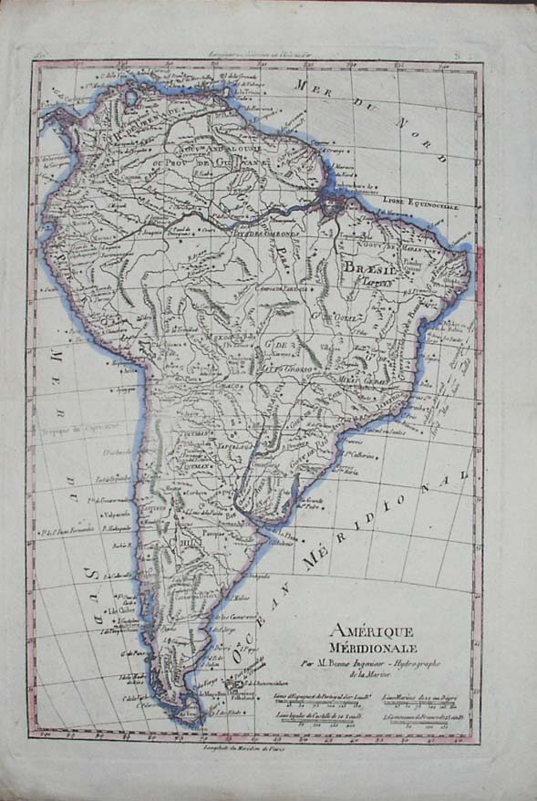
Map title
Amerique Meridionale
Author
Bonne
Location shown in map
South America
Edition date
1787
Edition place
Paris
Editor
--
Atlas
Atlas Encyclopedique
Price
Please ask: info@thetreasuremaps.com
State
[mint/excellent/very good/GOOD/fair/mediocre/poor]
Color
Modern outlined
Verso
Blank
Size
Plate: cm (31.8 x 21) inches (12.52 x 8.27) Paper: cm (31.8 x 21) inches (12.52 x 8.27)
Technique
Copper engraving
Note
No particular notes for this maps
Reference
--
Wiki
Here for more info
In stock
Sold
Info
info@thetreasuremaps.com
Code
#0399
×
![Amerique Meridionale by Bonne, South America, 1787]()
Map title
L'Asie
Author
Bonne
Location shown in map
--
Edition date
1787
Edition place
Paris
Editor
--
Atlas
Atlas Encyclopedique
Price
Please ask: info@thetreasuremaps.com
State
[mint/EXCELLENT/very good/good/fair/mediocre/poor]
Color
Black/white
Verso
Blank
Size
Plate: cm (31.8 x 21) inches (12.52 x 8.27) Paper: cm (40.6 x 26.7) inches (15.98 x 10.51)
Technique
Copper engraving
Note
Fine map of the continent including Japan, Philippines, Indonesia and northern tip of Australia.
Reference
--
Wiki
Here for more info
In stock
Sold
Info
info@thetreasuremaps.com
Code
#0398
×
![L'Asie by Bonne, --, 1787]()
Map title
Carte de l'Empire de Russie en Europe et en Asie
Author
Bonne
Location shown in map
Russie
Edition date
1787
Edition place
Paris
Editor
--
Atlas
Atlas Encyclopedique
Price
Please ask: info@thetreasuremaps.com
State
[mint/excellent/very good/good/FAIR/mediocre/poor]
Color
Modern outlined
Verso
Blank
Size
Plate: cm (31.8 x 21) inches (12.52 x 8.27) Paper: cm (36.8 x 25.4) inches (14.49 x 10)
Technique
Copper engraving
Note
No particular notes for this maps
Reference
--
Wiki
Here for more info
In stock
Sold
Info
info@thetreasuremaps.com
Code
#0397
×
![Carte de l'Empire de Russie en Europe et en Asie by Bonne, Russie, 1787]()
Map title
Les Isle Antilles Et Le Golfe Du Mexique
Author
Bonne
Location shown in map
--
Edition date
1787
Edition place
Paris
Editor
--
Atlas
Atlas Encyclopedique
Price
Please ask: info@thetreasuremaps.com
State
[mint/excellent/very good/GOOD/fair/mediocre/poor]
Color
Modern outlined
Verso
Blank
Size
Plate: cm (31.8 x 21) inches (12.52 x 8.27) Paper: cm (36.8 x 25.4) inches (14.49 x 10)
Technique
Copper engraving
Note
No particular notes for this maps
Reference
--
Wiki
Here for more info
In stock
Sold
Info
info@thetreasuremaps.com
Code
#0395
×
![Les Isle Antilles Et Le Golfe Du Mexique by Bonne, --, 1787]()
Map title
Carte De La Louisiane Et De La Floride
Author
Bonne
Location shown in map
--
Edition date
1787
Edition place
Paris
Editor
--
Atlas
Atlas Encyclopedique
Price
Please ask: info@thetreasuremaps.com
State
[mint/excellent/very good/GOOD/fair/mediocre/poor]
Color
Modern outlined
Verso
Blank
Size
Plate: cm (31.8 x 21) inches (12.52 x 8.27) Paper: cm (34.3 x 22.9) inches (13.5 x 9.02)
Technique
Copper engraving
Note
In the southeast is Florida and the eastern Atlantic coast reaching as far north as Charleston, South Carolina. In the northeast is part of Virginia. In the northwest corner is the Missouri river with several tributaries, including the Osage. The western part of the map is dominated by the Mississsippi river and it tributaries. The inset in the lower left shows the area of Jefferson City, Missouri where the Osage and Grand rivers flow into the Missouri.
Reference
--
Wiki
Here for more info
In stock
Sold
Info
info@thetreasuremaps.com
Code
#0394
×
![Carte De La Louisiane Et De La Floride by Bonne, --, 1787]()
Map title
Carte de France
Author
Bonne
Location shown in map
France
Edition date
1787
Edition place
Paris
Editor
--
Atlas
Atlas Encyclopedique
Price
Please ask: info@thetreasuremaps.com
State
[mint/excellent/very good/good/FAIR/mediocre/poor]
Color
Modern outlined
Verso
Blank
Size
Plate: cm (27.9 x 22.9) inches (10.98 x 9.02) Paper: cm (30.5 x 25.4) inches (12.01 x 10)
Technique
Copper engraving
Note
No particular notes for this maps
Reference
--
Wiki
Here for more info
In stock
Sold
Info
info@thetreasuremaps.com
Code
#0168
×
![Carte de France by Bonne, France, 1787]()
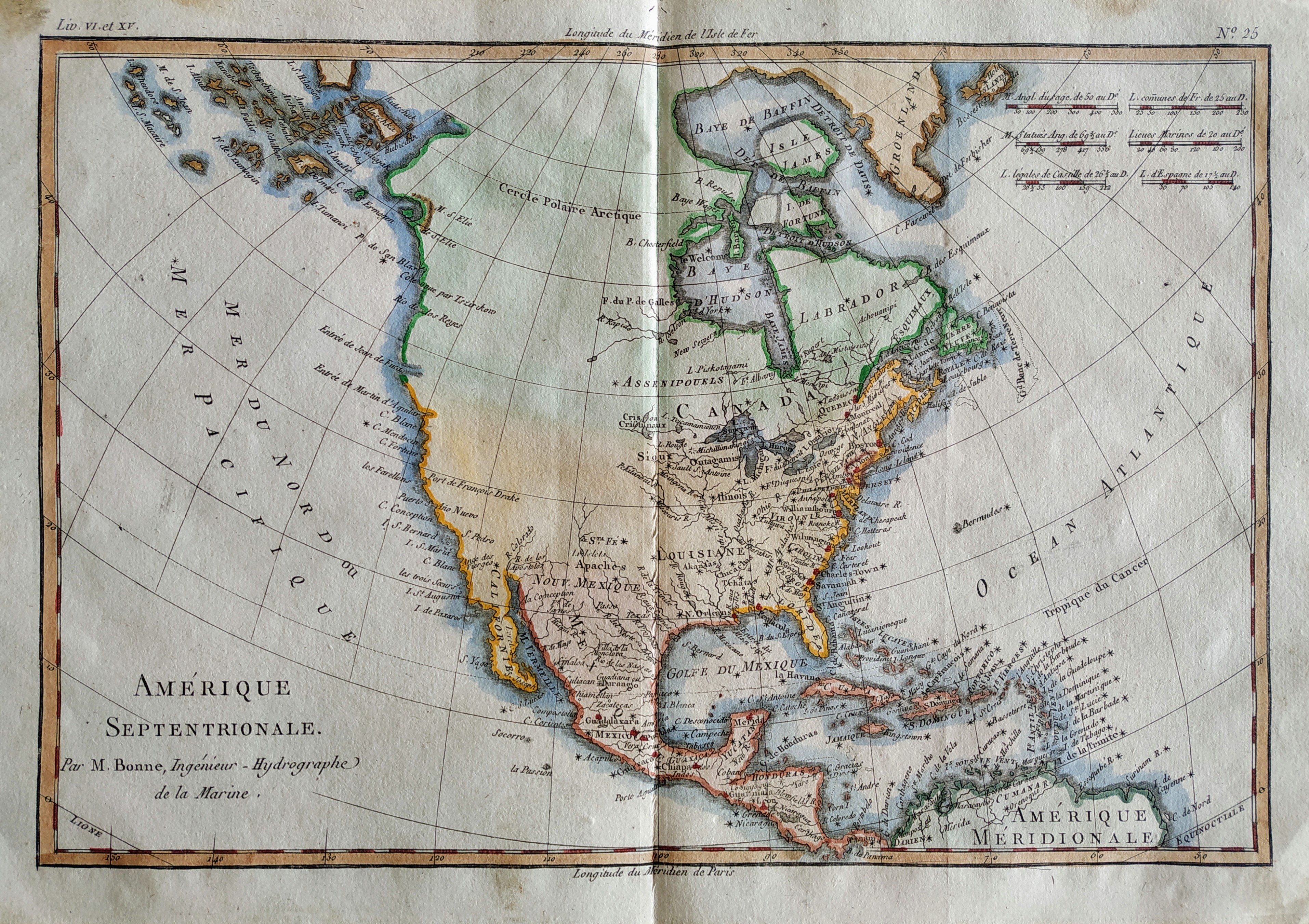
Map title
Amerique Septentrionale
Author
Bonne
Location shown in map
North America
Edition date
1789
Edition place
Paris
Editor
Atlas
Atlas Encyclopedique
Price
175 Euro
State
[mint/EXCELLENT/very good/good/fair/mediocre/poor]
Color
Old colors
Verso
Blank
Size
Plate: cm (32 x 22) inches (12.6 x 8.66) Paper: cm (36 x 25) inches (14.17 x 9.84)
Technique
Copper engraving
Note
Reference
Wiki
Here for more info
In stock
Available
Info
info@thetreasuremaps.com
Code
#0815
×
![Amerique Septentrionale by Bonne, North America, 1789]()
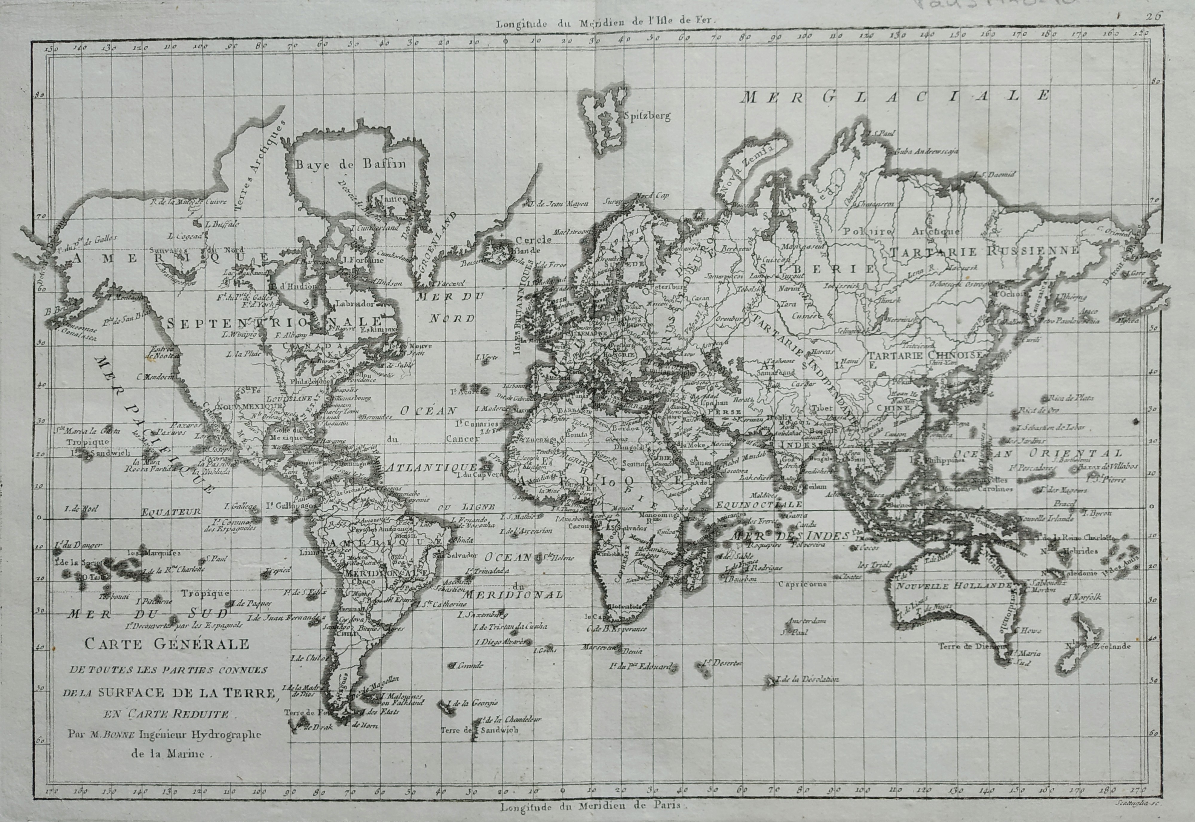
Map title
Carte generale des toutes les parties connues
Author
Bonne
Location shown in map
World
Edition date
1789
Edition place
Paris
Editor
Atlas
Atlas Encyclopedique
Price
150 Euro
State
[mint/EXCELLENT/very good/good/fair/mediocre/poor]
Color
Black/white
Verso
Blank
Size
Plate: cm (34 x 23) inches (13.39 x 9.06) Paper: cm (40 x 28) inches (15.75 x 11.02)
Technique
Copper engraving
Note
Reference
Wiki
Here for more info
In stock
Available
Info
info@thetreasuremaps.com
Code
#0779
×
![Carte generale des toutes les parties connues by Bonne, World, 1789]()
Pages: 1 2