Homann
Map title
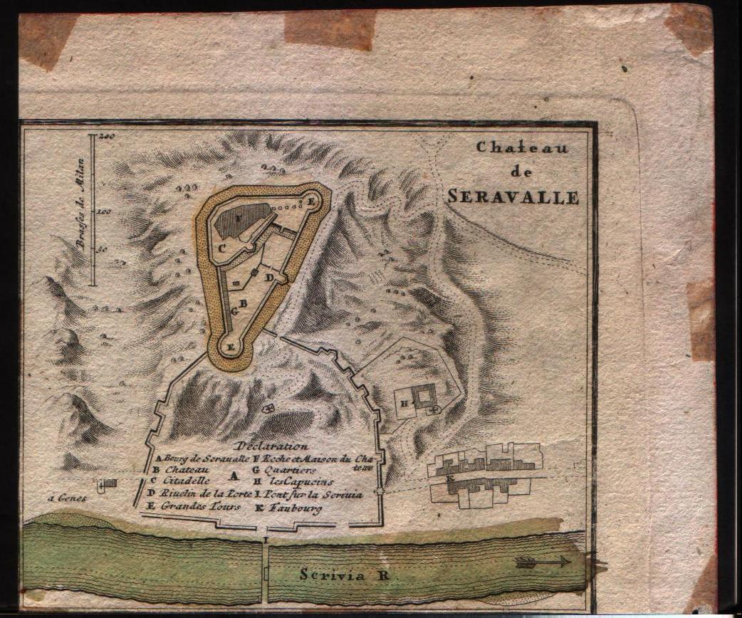
Pianta di Cremona e delle altre fortezze de Milano
Author
Homann
Location shown in map
Chateau de Seravalle
Edition date
Unknown
Edition place
--
Editor
--
Atlas
--
Price
Please ask: info@thetreasuremaps.com
State
[mint/excellent/very good/good/fair/mediocre/POOR] Only a small part of the map.
Color
Old outlined
Verso
Blank
Size
Plate: cm (14 x 12.7) inches (5.51 x 5) Paper: cm (16.5 x 15.2) inches (6.5 x 5.98)
Technique
Copper engraving
Note
No particular notes for this maps
Reference
--
Wiki
Here for more info
In stock
Available
Info
info@thetreasuremaps.com
Code
#0141
×
![]()
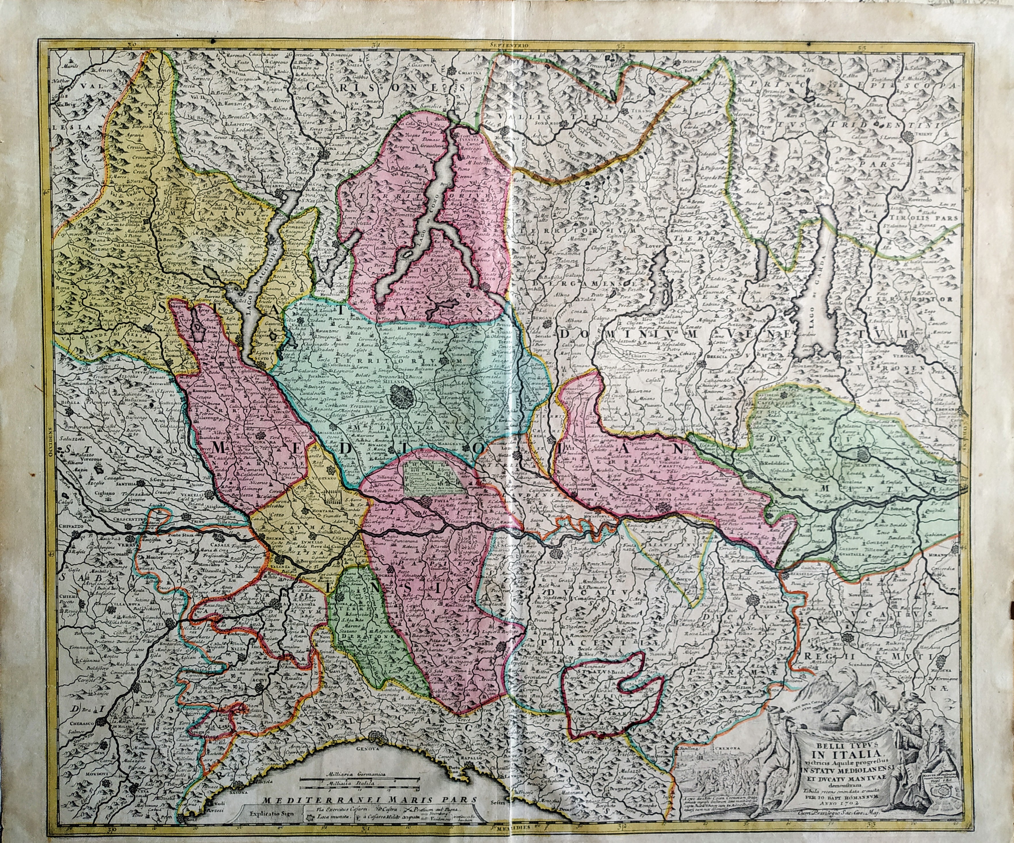
Map title
Belli typus in Italia in statu Mediolanesi
Author
Homann
Location shown in map
Lombardy
Edition date
1702
Edition place
?
Editor
--
Atlas
--
Price
350 Euro
State
[mint/excellent/VERY GOOD/good/fair/mediocre/poor]
Color
Old colors
Verso
Blank
Size
Plate: cm (55.9 x 48.3) inches (22.01 x 19.02) Paper: cm (61 x 50.8) inches (24.02 x 20)
Technique
Copper engraving
Note
--
Reference
--
Wiki
Here for more info
In stock
Available
Info
info@thetreasuremaps.com
Code
#0511
×
![]()
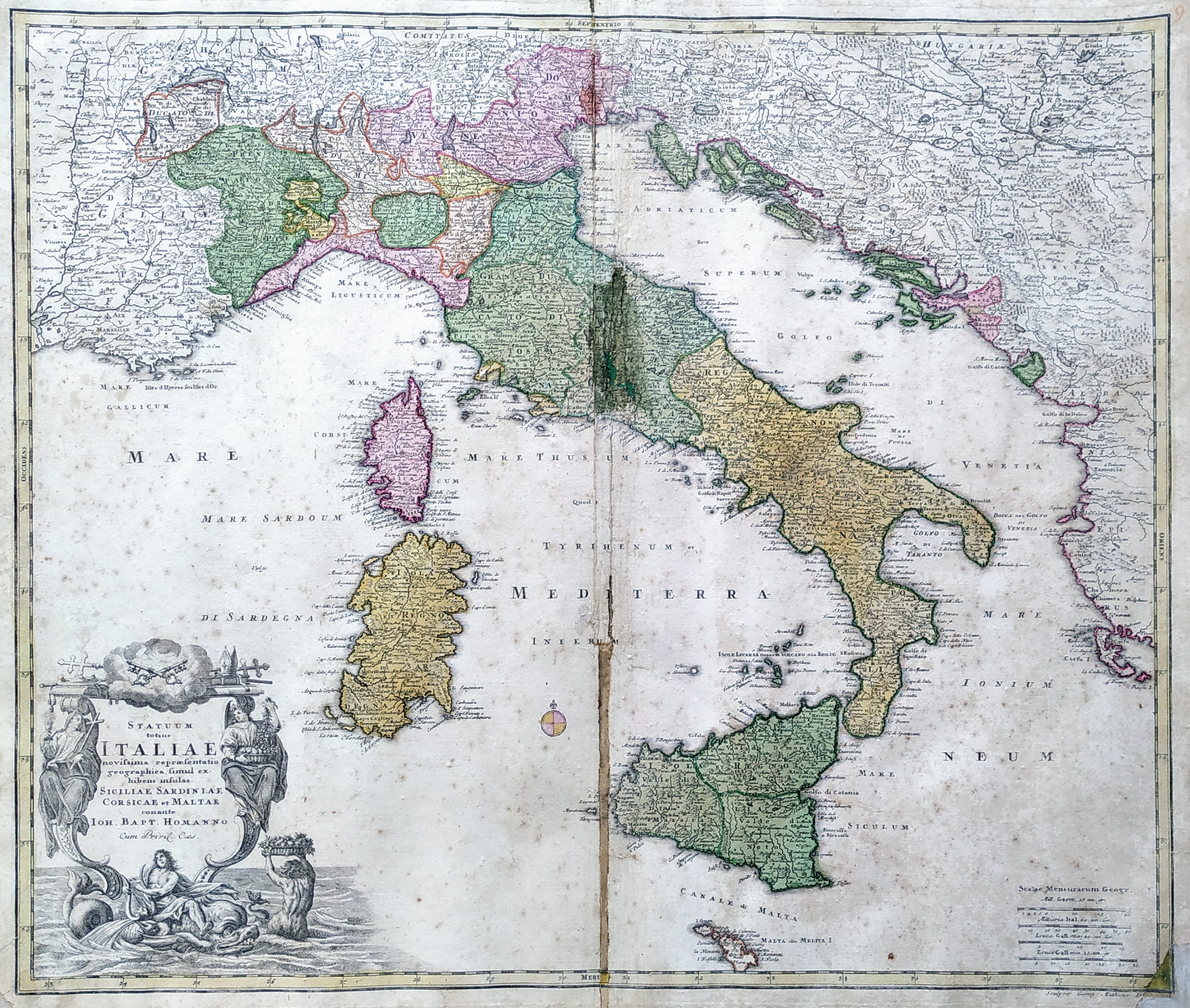
Map title
Statuum Totius Italiae Novissima Repraesentatio Geographica
Author
Homann
Location shown in map
Italy
Edition date
Circa 1712
Edition place
Nuremberg
Editor
Atlas
Price
350 Euro
State
[mint/excellent/very good/good/fair/mediocre/POOR]
Color
Old colors
Verso
Blank
Size
Plate: cm (58 x 50) inches (22.83 x 19.69) Paper: cm (62 x 53) inches (24.41 x 20.87)
Technique
Copper engraving
Note
Reference
R.Borri L'Italia nelle antiche carte pag.185
Wiki
Here for more info
In stock
Available
Info
info@thetreasuremaps.com
Code
#0812
×
![]()
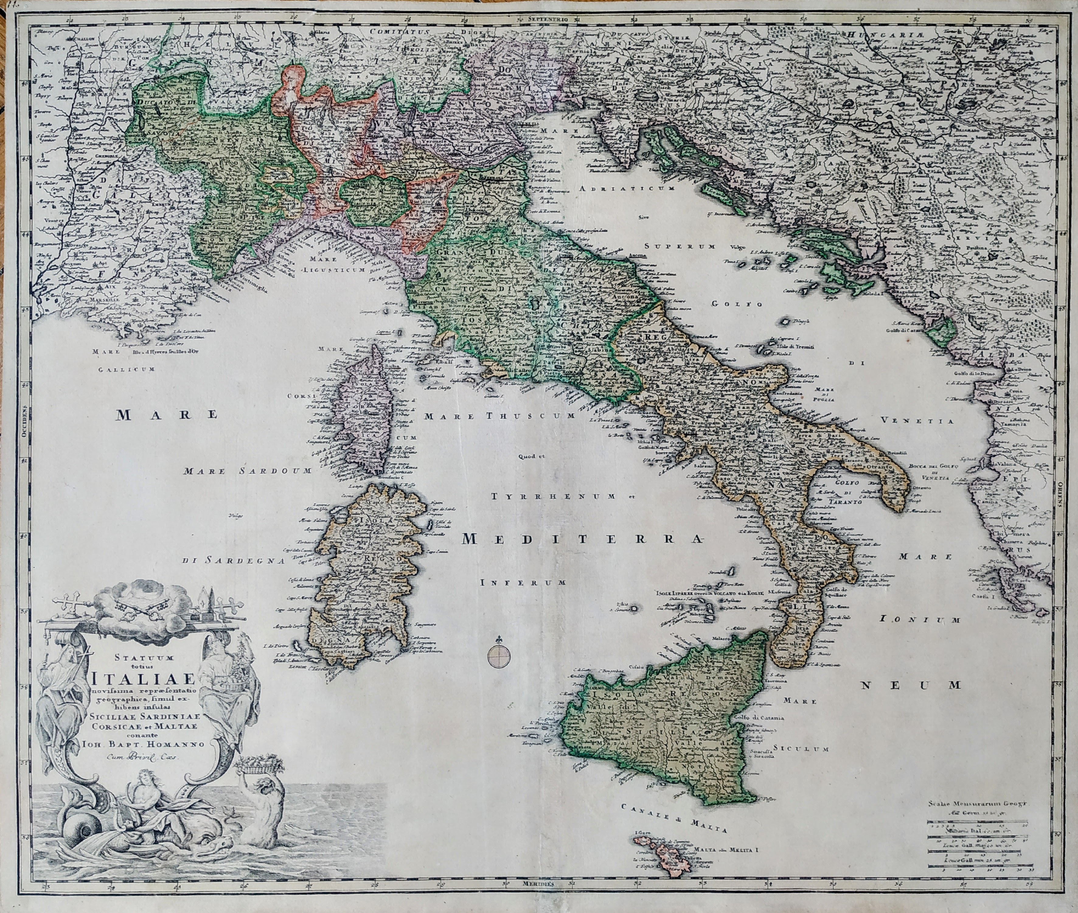
Map title
Statuum Totius Italiae Novissima Repraesentatio Geographica
Author
Homann
Location shown in map
Italy
Edition date
Circa 1712
Edition place
Nuremberg
Editor
Atlas
Price
400 Euro
State
[mint/EXCELLENT/very good/good/fair/mediocre/poor]
Color
Old colors
Verso
Blank
Size
Plate: cm (58 x 50) inches (22.83 x 19.69) Paper: cm (62 x 53) inches (24.41 x 20.87)
Technique
Copper engraving
Note
Reference
R.Borri L'Italia nelle antiche carte pag.185
Wiki
Here for more info
In stock
Available
Info
info@thetreasuremaps.com
Code
#0866
×
![]()

Map title
Totius regni Neapolis
Author
Homann
Location shown in map
South Italy
Edition date
Circa 1716
Edition place
Nurimberg
Editor
Atlas
Price
400 Euro
State
[mint/EXCELLENT/very good/good/fair/mediocre/poor]
Color
Old colors
Verso
Blank
Size
Plate: cm (51 x 60) inches (20.08 x 23.62) Paper: cm (48 x 56) inches (18.9 x 22.05)
Technique
Copper engraving
Note
framed
Reference
--
Wiki
Here for more info
In stock
Available
Info
info@thetreasuremaps.com
Code
#1227
×
![]()
Map title
Totius Africae Nova Repraesentatio qua per diversos in ea Status et Regiones, etiam Origo Nili ex veris R.R.P.P. Missionariorum Relationibus ostenditur
Author
Homann
Location shown in map
Africa
Edition date
1720
Edition place
Nuremberg
Editor
--
Atlas
--
Price
300 Euro
State
[mint/excellent/very good/good/FAIR/mediocre/poor]
Color
Old color
Verso
Blank
Size
Plate: cm (55.9 x 48.3) inches (22.01 x 19.02) Paper: cm (57.2 x 50.8) inches (22.52 x 20)
Technique
Copper engraving
Note
Some professional repaired tears. Missing rigth bottom corner 2mm
Reference
--
Wiki
Here for more info
In stock
Available
Info
info@thetreasuremaps.com
Code
#0327
×
![]()
Map title
Asiae Recentissima Delineatio Qua Status et Imperia Totius Orientis unacum Orientalibus Indiis
Author
Homann
Location shown in map
Asia
Edition date
Circa 1720
Edition place
Nurimberg
Editor
--
Atlas
Price
400 Euro
State
[mint/excellent/VERY GOOD/good/fair/mediocre/poor]
Color
Old colors
Verso
Blank
Size
Plate: cm (58 x 48) inches (22.83 x 18.9) Paper: cm (59 x 52) inches (23.23 x 20.47)
Technique
Copper engraving
Note
Reference
Wiki
Here for more info
In stock
Available
Info
info@thetreasuremaps.com
Code
#1282
×
![]()
Map title
Totius regni Galliae sive Franciae tabula
Author
Homann
Location shown in map
France
Edition date
Circa 1720
Edition place
Nurimberg
Editor
--
Atlas
Price
200 Euro
State
[mint/excellent/VERY GOOD/good/fair/mediocre/poor]
Color
Old colors
Verso
Blank
Size
Plate: cm (58 x 48) inches (22.83 x 18.9) Paper: cm (59 x 52) inches (23.23 x 20.47)
Technique
Copper engraving
Note
Reference
Wiki
Here for more info
In stock
Available
Info
info@thetreasuremaps.com
Code
#1281
×
![]()
Map title
Ducatus Mediolani
Author
Homann
Location shown in map
Liguria
Edition date
Circa 1720
Edition place
Nuremberg
Editor
--
Atlas
--
Price
350 Euro
State
[mint/excellent/VERY GOOD/good/fair/mediocre/poor]
Color
Old colors
Verso
Blank
Size
Plate: cm (0 x 0) inches (0 x 0) Paper: cm (0 x 0) inches (0 x 0)
Technique
Copper engraving
Note
Framed
Reference
--
Wiki
Here for more info
In stock
Available
Info
info@thetreasuremaps.com
Code
#1099
×
![]()
Map title
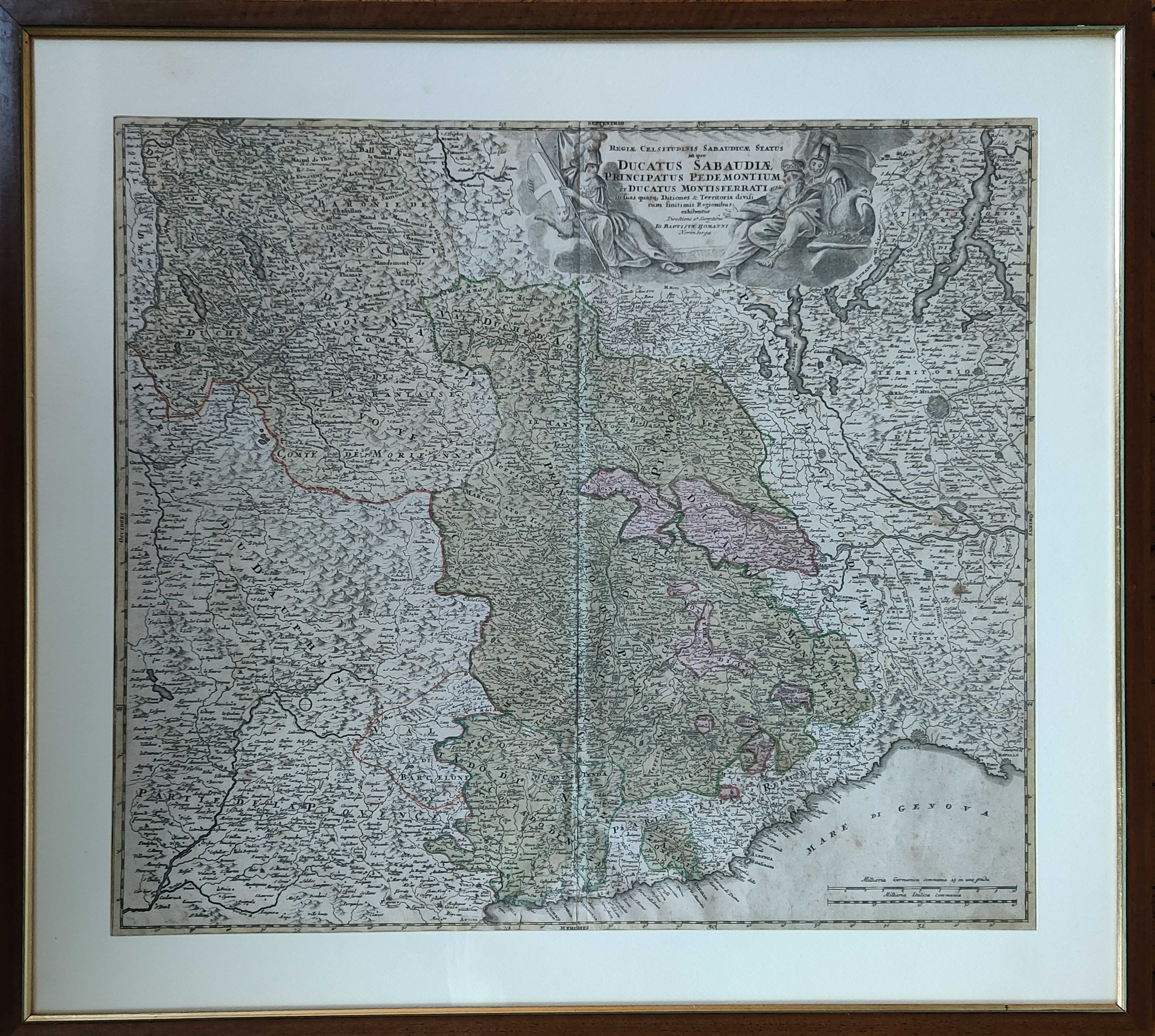
Ducatus Sabaudiae Principatus Pedemontium et Ducatus Montisferratis
Author
Homann
Location shown in map
Piedmont
Edition date
Circa 1720
Edition place
Nuremberg
Editor
--
Atlas
--
Price
350 Euro
State
[mint/excellent/VERY GOOD/good/fair/mediocre/poor]
Color
Old colors
Verso
Blank
Size
Plate: cm (55.9 x 48.3) inches (22.01 x 19.02) Paper: cm (61 x 50.8) inches (24.02 x 20)
Technique
Copper engraving
Note
Framed
Reference
--
Wiki
Here for more info
In stock
Available
Info
info@thetreasuremaps.com
Code
#1098
×
![]()
Map title
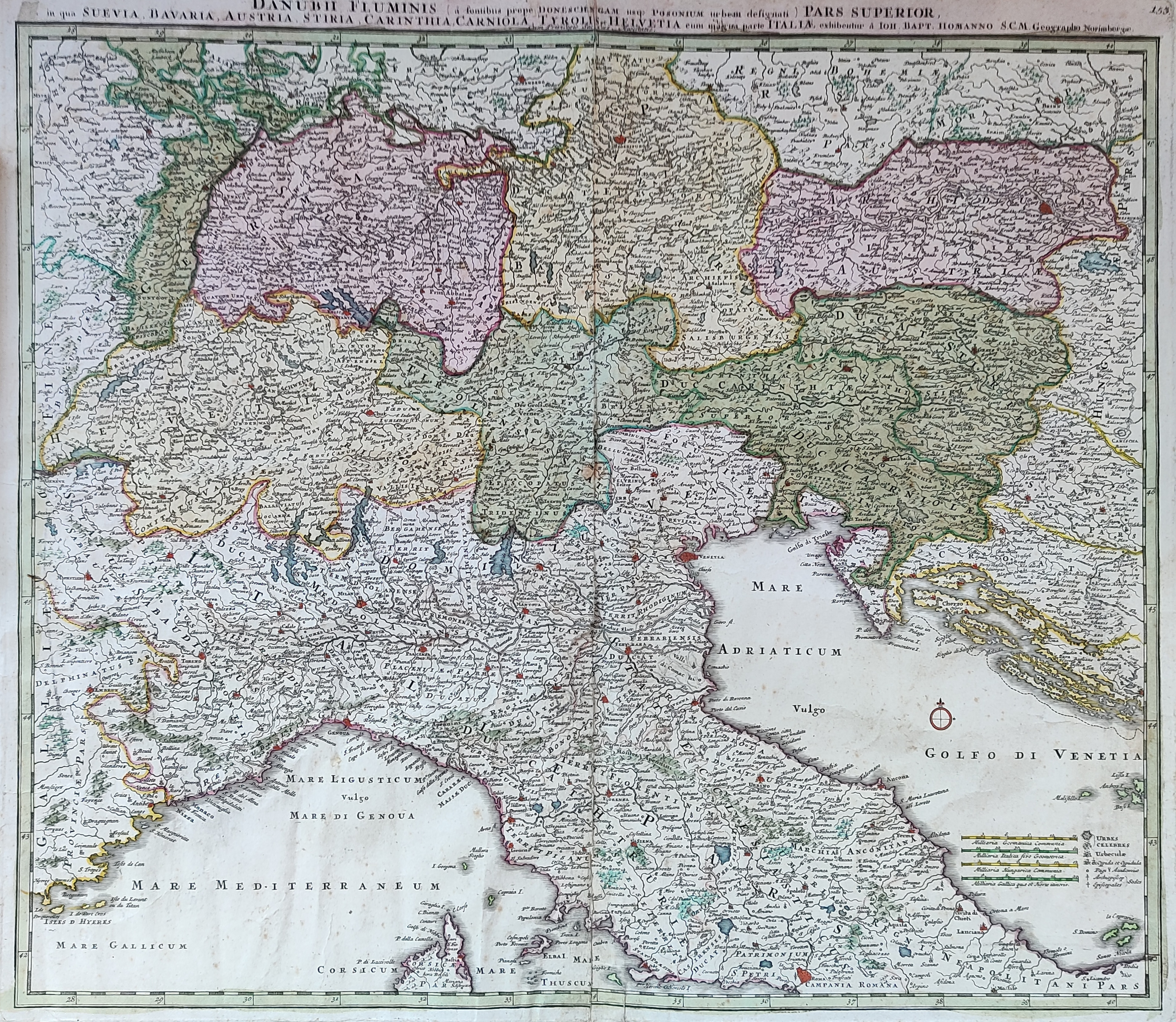
Danubii Fluminis
Author
Homann
Location shown in map
North Italy
Edition date
1720
Edition place
Nurnberg
Editor
Atlas
Price
400 Euro
State
[mint/EXCELLENT/very good/good/fair/mediocre/poor]
Color
Old colors
Verso
Blank
Size
Plate: cm (55 x 47) inches (21.65 x 18.5) Paper: cm (62 x 52) inches (24.41 x 20.47)
Technique
Copper engraving
Note
Reference
Wiki
Here for more info
In stock
Available
Info
info@thetreasuremaps.com
Code
#1085
×
![]()
Map title
Ducatus Sabaudiae Principatus Pedemontium et Ducatus Montisferratis
Author
Homann
Location shown in map
Piedmont
Edition date
1720
Edition place
Nuremberg
Editor
--
Atlas
--
Price
350 Euro
State
[mint/excellent/VERY GOOD/good/fair/mediocre/poor]
Color
Old colors
Verso
Blank
Size
Plate: cm (55.9 x 48.3) inches (22.01 x 19.02) Paper: cm (61 x 50.8) inches (24.02 x 20)
Technique
Copper engraving
Note
--
Reference
--
Wiki
Here for more info
In stock
Available
Info
info@thetreasuremaps.com
Code
#0510
×
![]()

Map title
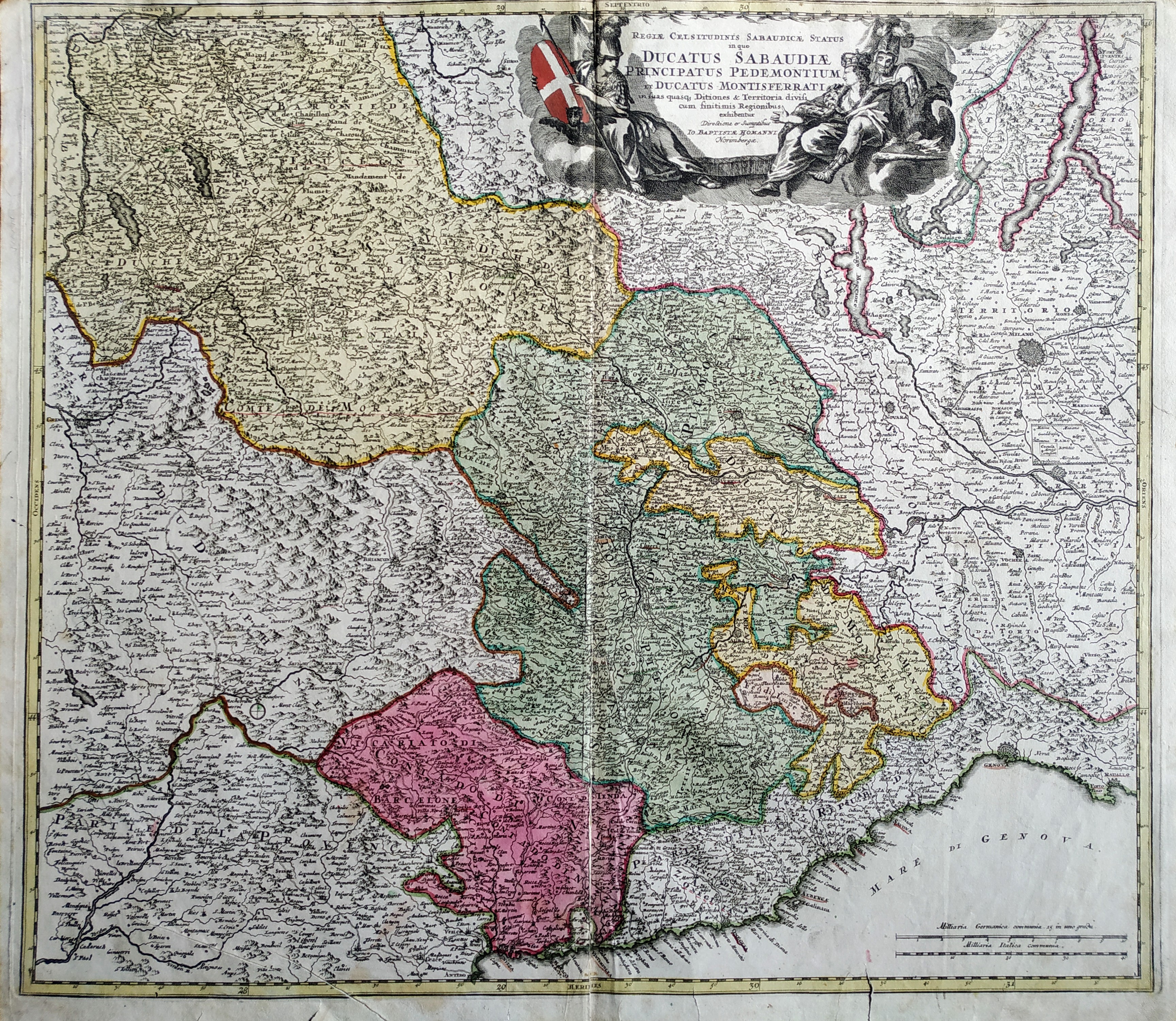
Regiae celsitudinis Sabaudiciae statu in quo Ducatus Sabaudiae Principatus Pedemontium et Ducatus Montisferrati
Author
Homann
Location shown in map
North-West Italy
Edition date
1720
Edition place
Nuremberg
Editor
--
Atlas
--
Price
Please ask: info@thetreasuremaps.com
State
[mint/excellent/very good/GOOD/fair/mediocre/poor]
Color
Old color
Verso
Blank
Size
Plate: cm (55.9 x 49.5) inches (22.01 x 19.49) Paper: cm (58.4 x 52.1) inches (22.99 x 20.51)
Technique
Copper engraving
Note
Some professional repaired tears. Missing left bottom corner 2mm
Reference
--
Wiki
Here for more info
In stock
Sold
Info
info@thetreasuremaps.com
Code
#0444
×
![]()

Map title
Cursus Fluminis Padi vel Po per Longobardiam
Author
Homann
Location shown in map
Liguria
Edition date
1735
Edition place
Editor
Atlas
Atlas compendiarius
Price
300 Euro
State
[mint/EXCELLENT/very good/good/fair/mediocre/poor]
Color
Old colors
Verso
Blank
Size
Plate: cm (60 x 54) inches (23.62 x 21.26) Paper: cm (58 x 50) inches (22.83 x 19.69)
Technique
Copper engraving
Note
Reference
Wiki
Here for more info
In stock
Available
Info
info@thetreasuremaps.com
Code
#1228
×
![]()
Map title
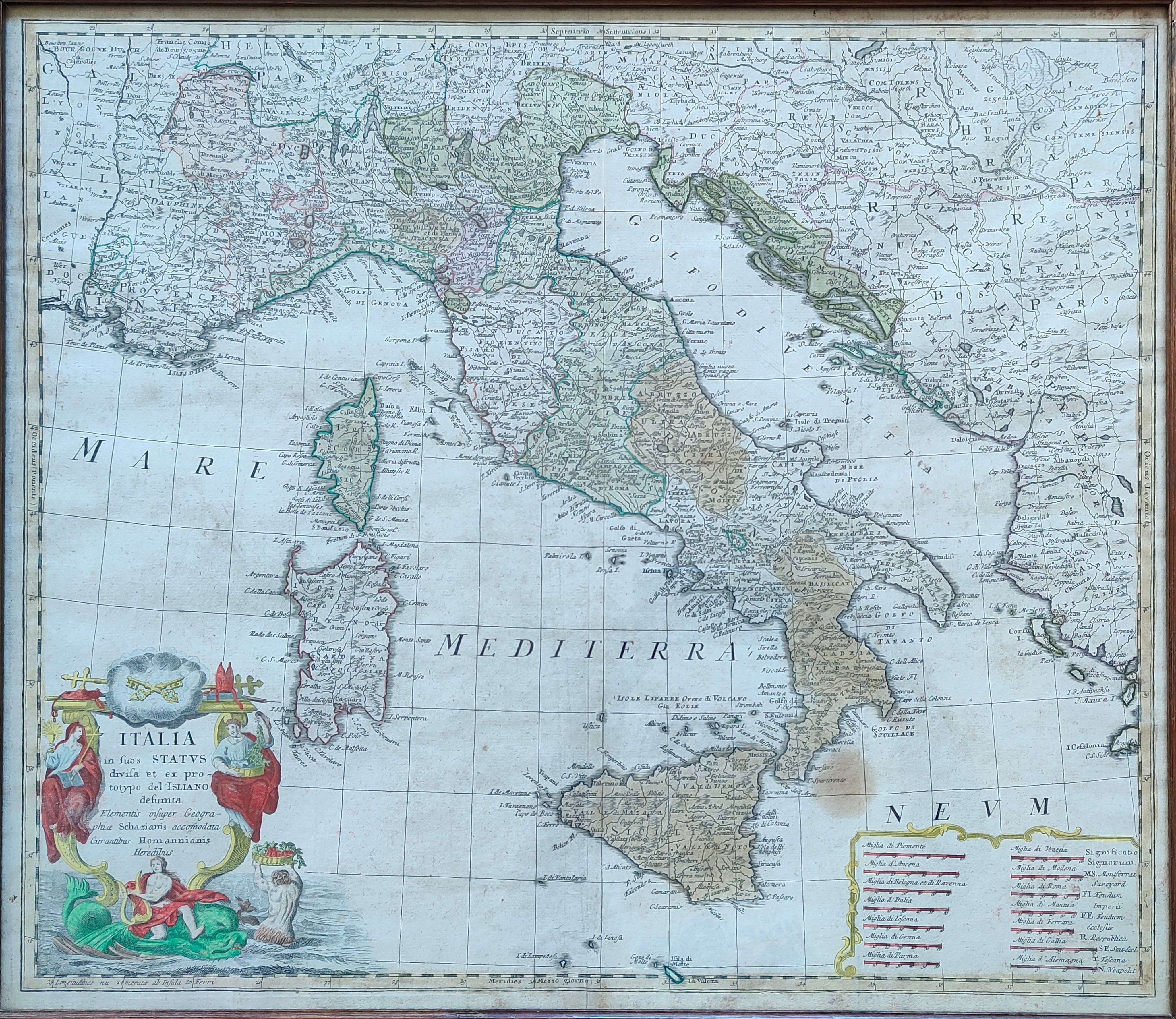
Italia in suos status divisa
Author
Homann
Location shown in map
Italy
Edition date
1742
Edition place
Nuremberg
Editor
Atlas
Price
350 Euro
State
[mint/EXCELLENT/very good/good/fair/mediocre/poor]
Color
Old colors
Verso
Blank
Size
Plate: cm (57 x 49) inches (22.44 x 19.29) Paper: cm (58 x 50) inches (22.83 x 19.69)
Technique
Copper engraving
Note
Framed
Reference
R.Borri L'Italia nelle antiche carte pag.221
Wiki
Here for more info
In stock
Available
Info
info@thetreasuremaps.com
Code
#1127
×
![]()
Map title
Carta Geographica, la quale rappresenta lo Stato della Republica di Genova
Author
Homann
Location shown in map
Liguria
Edition date
1743
Edition place
Nuremberg
Editor
Atlas
Price
900 Euro
State
[mint/EXCELLENT/very good/good/fair/mediocre/poor]
Color
Old colors
Verso
Blank
Size
Plate: cm (56 x 50) inches (22.05 x 19.69) Paper: cm (63 x 52) inches (24.8 x 20.47)
Technique
Copper engraving
Note
Reference
Wiki
Here for more info
In stock
Available
Info
info@thetreasuremaps.com
Code
#1198
×
![]()
Map title
Author
Homann
Location shown in map
South-east Asia
Edition date
1748
Edition place
Nuremberg
Editor
--
Atlas
--
Price
Please ask: info@thetreasuremaps.com
State
[mint/excellent/VERY GOOD/good/fair/mediocre/poor]
Color
Old color
Verso
Blank
Size
Plate: cm (43.2 x 49.5) inches (17.01 x 19.49) Paper: cm (50.8 x 52.1) inches (20 x 20.51)
Technique
Copper engraving
Note
--
Reference
--
Wiki
Here for more info
In stock
Sold
Info
info@thetreasuremaps.com
Code
#0454
×
![]()
Map title
Status Ecclesiastici nec non Magni Ducatus Toscanae Nova Tabula Geographica
Author
Homann
Location shown in map
Lazio
Edition date
1748
Edition place
Amsterdam
Editor
Atlas
L'Italia
Price
250 Euro
State
[mint/EXCELLENT/very good/good/fair/mediocre/poor]
Color
Old colors
Verso
Blank
Size
Plate: cm (53 x 48) inches (20.87 x 18.9) Paper: cm (59 x 50) inches (23.23 x 19.69)
Technique
Copper engraving
Note
Reference
--
Wiki
Here for more info
In stock
Available
Info
info@thetreasuremaps.com
Code
#1324
×
![]()
Map title
Italia Benedictina
Author
Homann
Location shown in map
Italy
Edition date
Circa 1750
Edition place
Nurimberg
Editor
Atlas
Price
500 Euro
State
[mint/EXCELLENT/very good/good/fair/mediocre/poor]
Color
Old colors
Verso
Blank
Size
Plate: cm (55 x 47) inches (21.65 x 18.5) Paper: cm (60 x 52) inches (23.62 x 20.47)
Technique
Copper engraving
Note
Reference
R.Borri L'Italia nelle antiche carte pag.221
Wiki
Here for more info
In stock
Available
Info
info@thetreasuremaps.com
Code
#1265
×
![]()
Map title
America septentrionalis
Author
Homann
Location shown in map
USA
Edition date
1756
Edition place
Nuremberg
Editor
Atlas
Price
800 Euro
State
[mint/EXCELLENT/very good/good/fair/mediocre/poor]
Color
Old colors
Verso
Blank
Size
Plate: cm (55 x 42) inches (21.65 x 16.54) Paper: cm (62 x 52) inches (24.41 x 20.47)
Technique
Copper engraving
Note
United States of America shortly before the revolution, still an English colony
Reference
Wiki
Here for more info
In stock
Available
Info
info@thetreasuremaps.com
Code
#1331
×
![]()
Map title
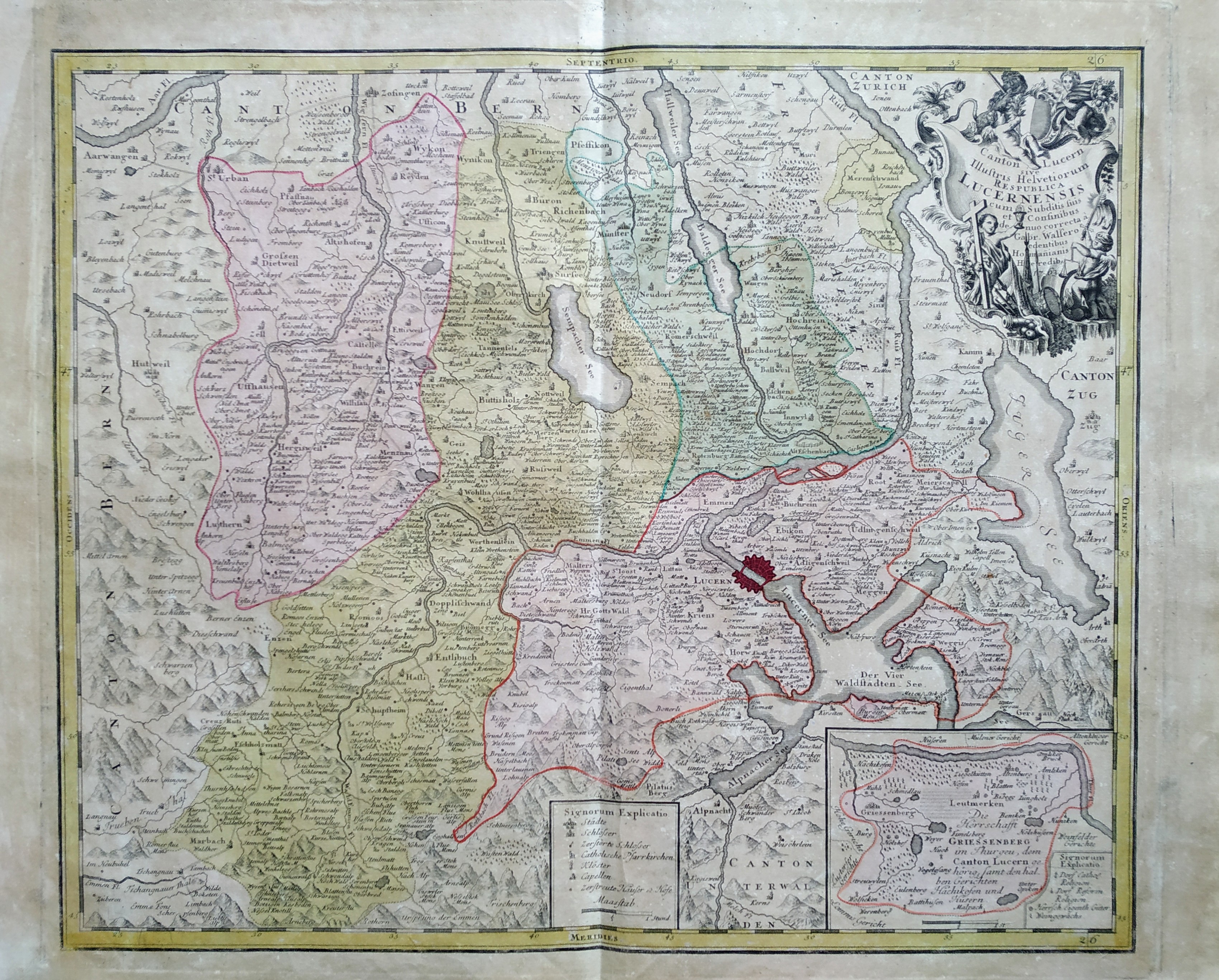
Canton Lucern sive illustris helvetiorum respublica Lucernensis cum subditis suis et confinibus
Author
Homann
Location shown in map
Lucerne
Edition date
1763
Edition place
Nuremberg
Editor
Atlas
Price
200 Euro
State
[mint/EXCELLENT/very good/good/fair/mediocre/poor]
Color
Old colors
Verso
Blank
Size
Plate: cm (51 x 59) inches (20.08 x 23.23) Paper: cm (55 x 64) inches (21.65 x 25.2)
Technique
Copper engraving
Note
Reference
Wiki
Here for more info
In stock
Available
Info
info@thetreasuremaps.com
Code
#0735
×
![]()
Map title
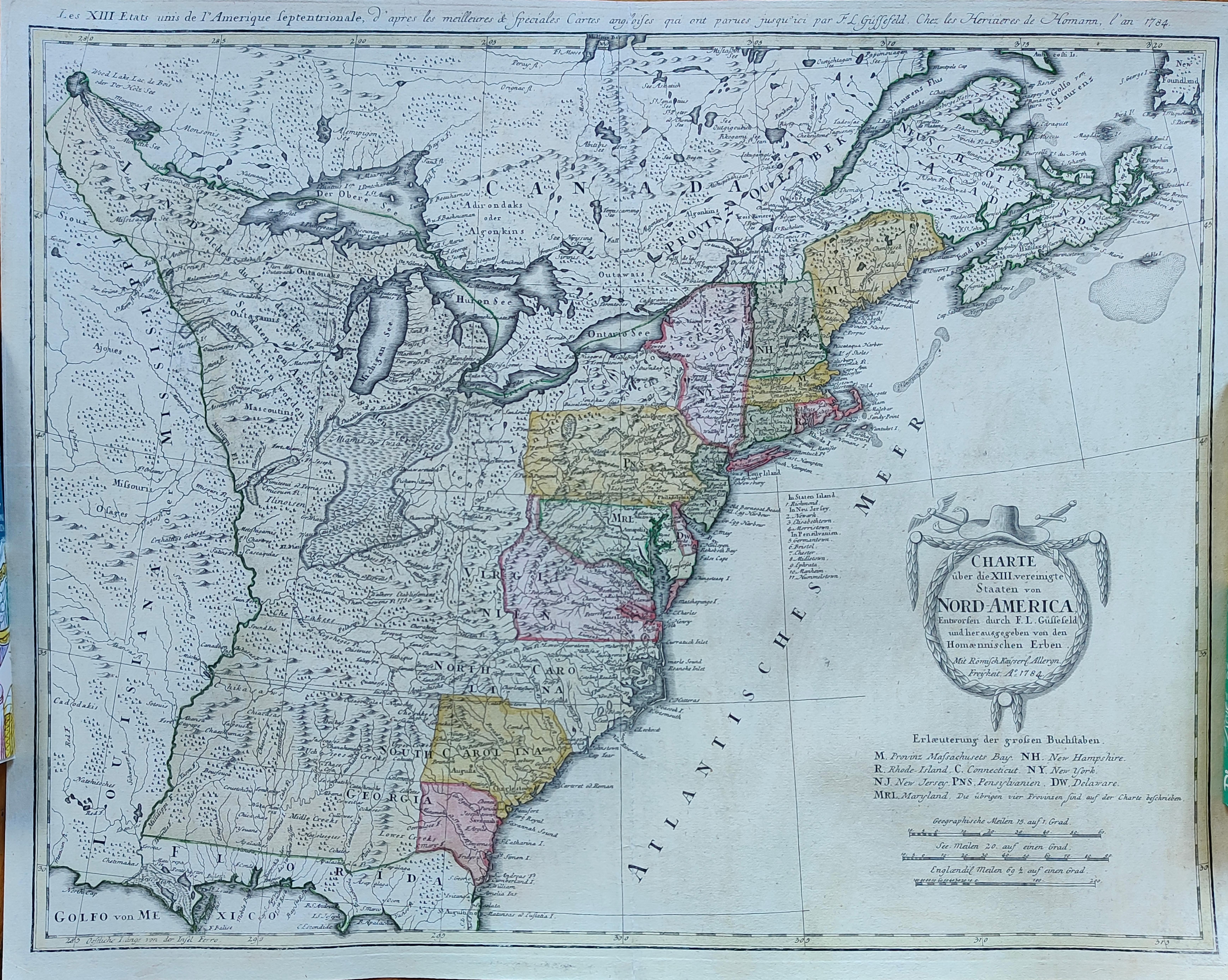
Charte uber die XIII Vereinigte Staaten von Nord-America
Author
Homann
Location shown in map
USA
Edition date
1784
Edition place
Nuremberg
Editor
Atlas
Price
1300 Euro
State
[mint/EXCELLENT/very good/good/fair/mediocre/poor]
Color
Old colors
Verso
Blank
Size
Plate: cm (58 x 45) inches (22.83 x 17.72) Paper: cm (60 x 49) inches (23.62 x 19.29)
Technique
Copper engraving
Note
United States of America shortly after the revolution
Reference
Wiki
Here for more info
In stock
Available
Info
info@thetreasuremaps.com
Code
#1288
×
![]()