Mercator
Pages: 1 2
Map title
Europa
Author
Mercator
Location shown in map
Europe
Edition date
Circa 1595
Edition place
Amsterdam
Editor
Hondius
Atlas
Mercator-Hondius Atlas.
Price
1200 Euro
State
[mint/EXCELLENT/very good/good/fair/mediocre/poor]
Color
Old colors
Verso
French text pag.53
Size
Plate: cm (47 x 38) inches (18.5 x 14.96) Paper: cm (54 x 46) inches (21.26 x 18.11)
Technique
Copper engraving
Note
Professionally restored
Reference
Wiki
Here for more info
In stock
Available
Info
info@thetreasuremaps.com
Code
#1330
×
![Europa by Mercator, Europe, Circa 1595]()
Map title
Asia ex magna orbis terre descriptione Gerardi Mercatoris Desumpta studio et industria G.M. Iumioris
Author
Mercator
Location shown in map
Asia
Edition date
Circa 1595
Edition place
Amsterdam
Editor
Hondius
Atlas
Price
1500 Euro
State
[mint/excellent/VERY GOOD/good/fair/mediocre/poor]
Color
Black/white
Verso
Size
Plate: cm (49 x 39) inches (19.29 x 15.35) Paper: cm (49 x 39) inches (19.29 x 15.35)
Technique
Copper engraving
Note
Reference
Wiki
Here for more info
In stock
Available
Info
info@thetreasuremaps.com
Code
#0906
×
![Asia ex magna orbis terre descriptione Gerardi Mercatoris Desumpta studio et industria G.M. Iumioris by Mercator, Asia, Circa 1595]()
Map title
Hungaria
Author
Mercator
Location shown in map
Hungary
Edition date
1606
Edition place
Amsterdam
Editor
--
Atlas
Mercator-Hondius Atlas.
Price
200 Euro
State
[mint/excellent/very good/GOOD/fair/mediocre/poor]
Color
Black/white
Verso
French text
Size
Plate: cm (41.9 x 36.8) inches (16.5 x 14.49) Paper: cm (55.9 x 45.7) inches (22.01 x 17.99)
Technique
Copper engraving
Note
No particular notes for this maps
Reference
--
Wiki
Here for more info
In stock
Available
Info
info@thetreasuremaps.com
Code
#0130
×
![Hungaria by Mercator, Hungary, 1606]()
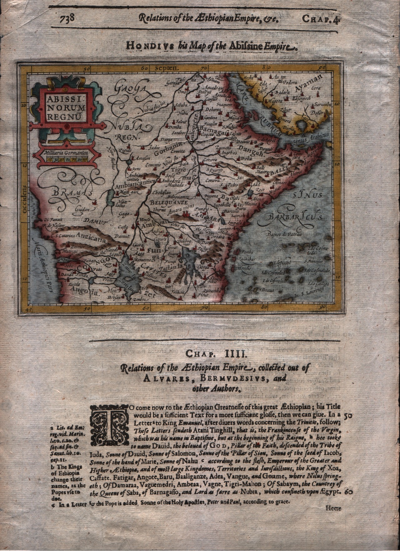
Map title
Abissinorum regnum
Author
Mercator
Location shown in map
East Africa
Edition date
1607
Edition place
Amsterdam
Editor
Janssonius
Atlas
Altas Minor Gerardi Mercatoris
Price
150 Euro
State
[mint/EXCELLENT/very good/good/fair/mediocre/poor]
Color
Black/white
Verso
Latin text pag.596
Size
Plate: cm (17.8 x 14) inches (7.01 x 5.51) Paper: cm (22.9 x 17.8) inches (9.02 x 7.01)
Technique
Copper engraving
Note
No particular notes for this maps
Reference
--
Wiki
Here for more info
In stock
Available
Info
info@thetreasuremaps.com
Code
#0291
×
![Abissinorum regnum by Mercator, East Africa, 1607]()
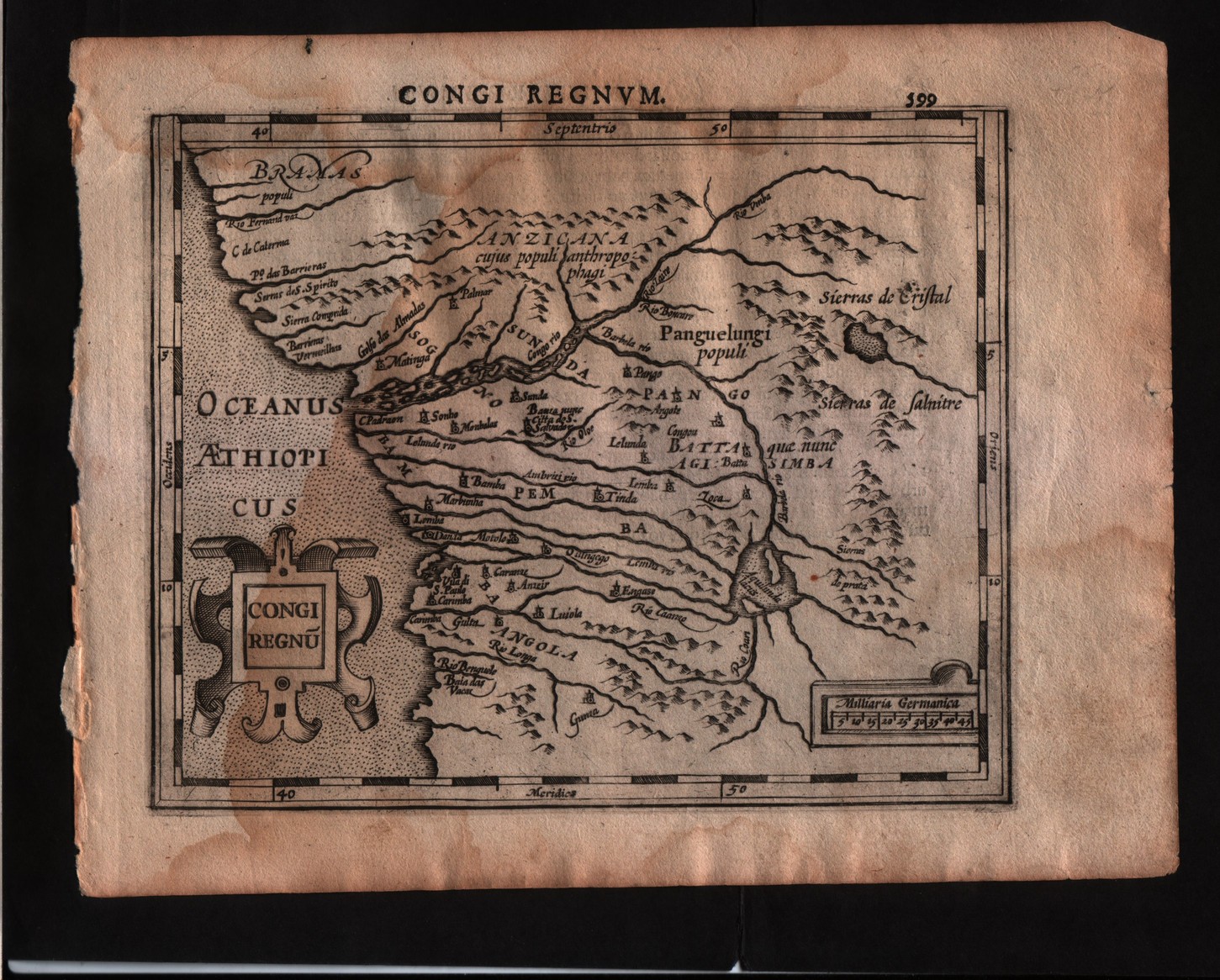
Map title
Congi regnum
Author
Mercator
Location shown in map
Congo
Edition date
1607
Edition place
Amsterdam
Editor
Janssonius
Atlas
Altas Minor Gerardi Mercatoris
Price
150 Euro
State
[mint/EXCELLENT/very good/good/fair/mediocre/poor]
Color
Black/white
Verso
Latin text pag.600
Size
Plate: cm (17.8 x 14) inches (7.01 x 5.51) Paper: cm (22.9 x 17.8) inches (9.02 x 7.01)
Technique
Copper engraving
Note
No particular notes for this maps
Reference
--
Wiki
Here for more info
In stock
Available
Info
info@thetreasuremaps.com
Code
#0292
×
![Congi regnum by Mercator, Congo, 1607]()
Map title
Italia
Author
Mercator
Location shown in map
Italy
Edition date
1610
Edition place
Amsterdam
Editor
Houndius
Atlas
Altas Minor Gerardi Mercatoris
Price
250 Euro
State
[mint/EXCELLENT/very good/good/fair/mediocre/poor]
Color
Black/white
Verso
Latin text 480
Size
Plate: cm (19 x 15) inches (7.48 x 5.91) Paper: cm (21 x 17.5) inches (8.27 x 6.89)
Technique
Copper engraving
Note
Reference
R.Borri L'Italia nelle antiche carte pag.66
Wiki
Here for more info
In stock
Available
Info
info@thetreasuremaps.com
Code
#0783
×
![Italia by Mercator, Italy, 1610]()
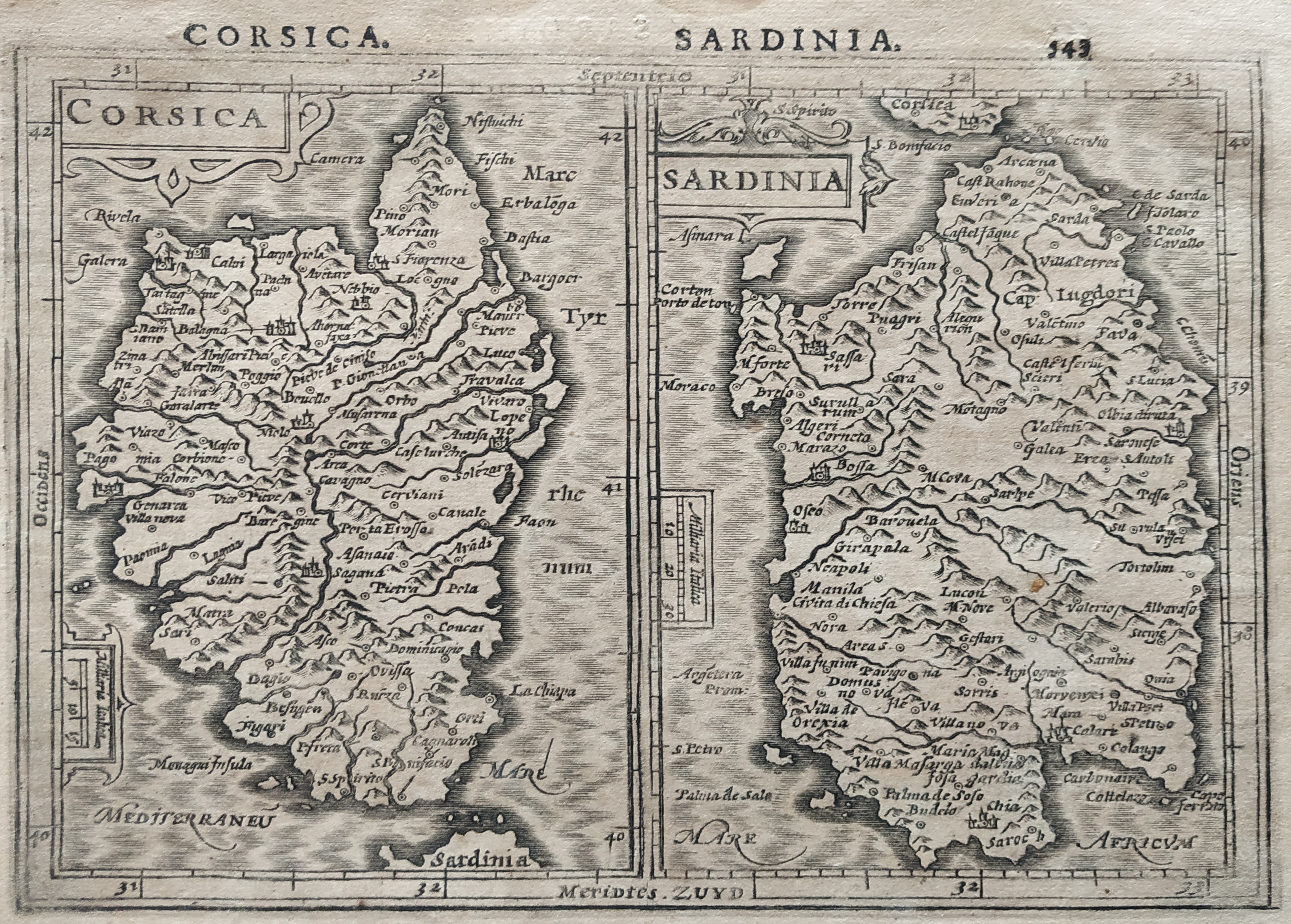
Map title
Corsica Sardinia
Author
Mercator
Location shown in map
Sardinia
Edition date
1610
Edition place
Amsterdam
Editor
Houndius
Atlas
Altas Minor Gerardi Mercatoris
Price
200 Euro
State
[mint/EXCELLENT/very good/good/fair/mediocre/poor]
Color
Black/white
Verso
Latin text 544
Size
Plate: cm (19 x 15) inches (7.48 x 5.91) Paper: cm (21 x 17.5) inches (8.27 x 6.89)
Technique
Copper engraving
Note
No particular notes for this maps.
Reference
Wiki
Here for more info
In stock
Available
Info
info@thetreasuremaps.com
Code
#0782
×
![Corsica Sardinia by Mercator, Sardinia, 1610]()
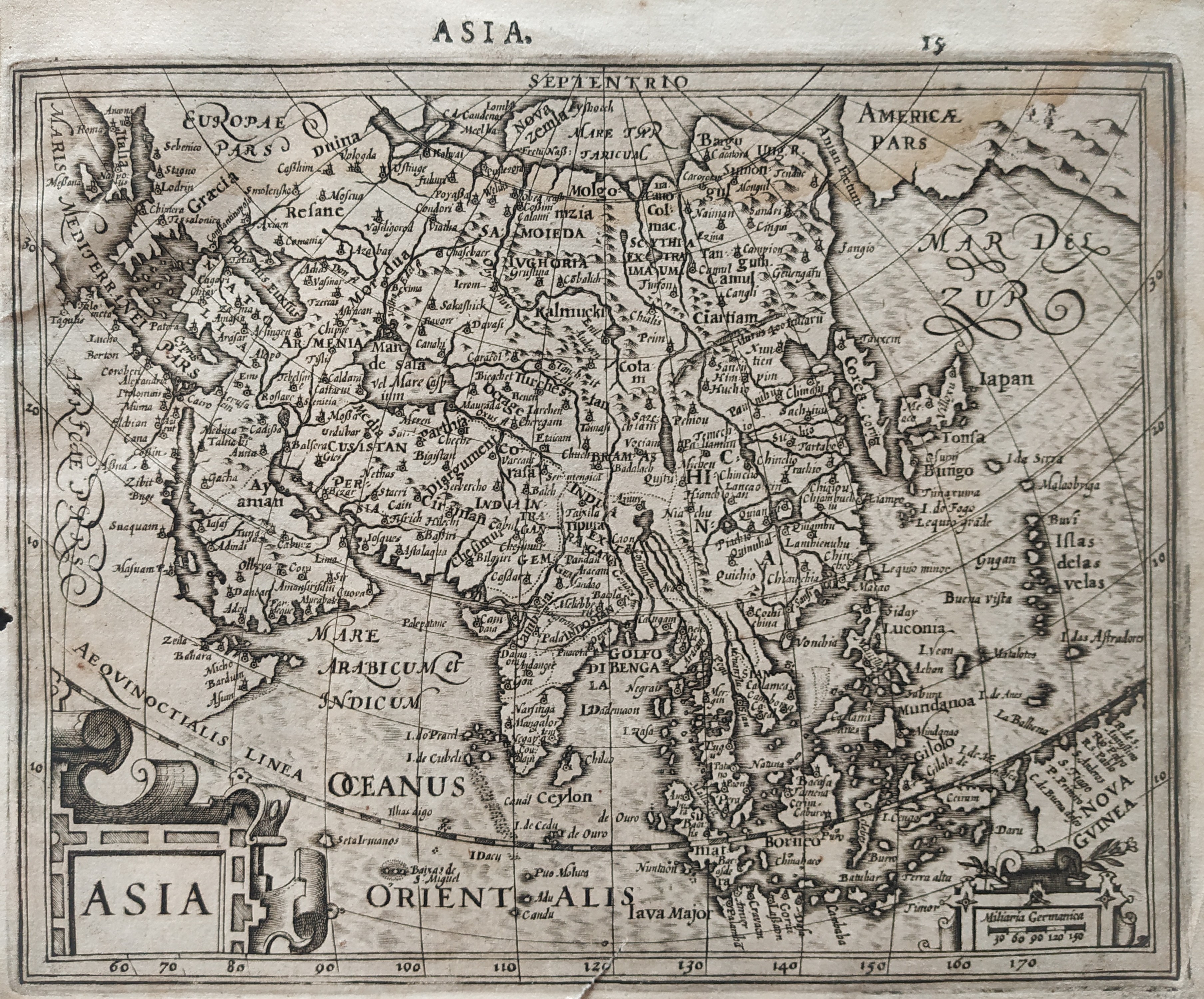
Map title
Asia
Author
Mercator
Location shown in map
Asia
Edition date
1610
Edition place
Amsterdam
Editor
Houndius
Atlas
Altas Minor Gerardi Mercatoris
Price
200 Euro
State
[mint/EXCELLENT/very good/good/fair/mediocre/poor]
Color
Black/white
Verso
Latin text 16
Size
Plate: cm (19 x 15) inches (7.48 x 5.91) Paper: cm (21 x 17.5) inches (8.27 x 6.89)
Technique
Copper engraving
Note
No particular notes for this maps.
Reference
Wiki
Here for more info
In stock
Available
Info
info@thetreasuremaps.com
Code
#0781
Asia
Author
Mercator
Location shown in map
Asia
Edition date
1610
Edition place
Amsterdam
Editor
Houndius
Atlas
Altas Minor Gerardi Mercatoris
Price
200 Euro
State
[mint/EXCELLENT/very good/good/fair/mediocre/poor]
Color
Black/white
Verso
Latin text 16
Size
Plate: cm (19 x 15) inches (7.48 x 5.91) Paper: cm (21 x 17.5) inches (8.27 x 6.89)
Technique
Copper engraving
Note
No particular notes for this maps.
Reference
Wiki
Here for more info
In stock
Available
Info
info@thetreasuremaps.com
Code
#0781
×
![Asia by Mercator, Asia, 1610]()
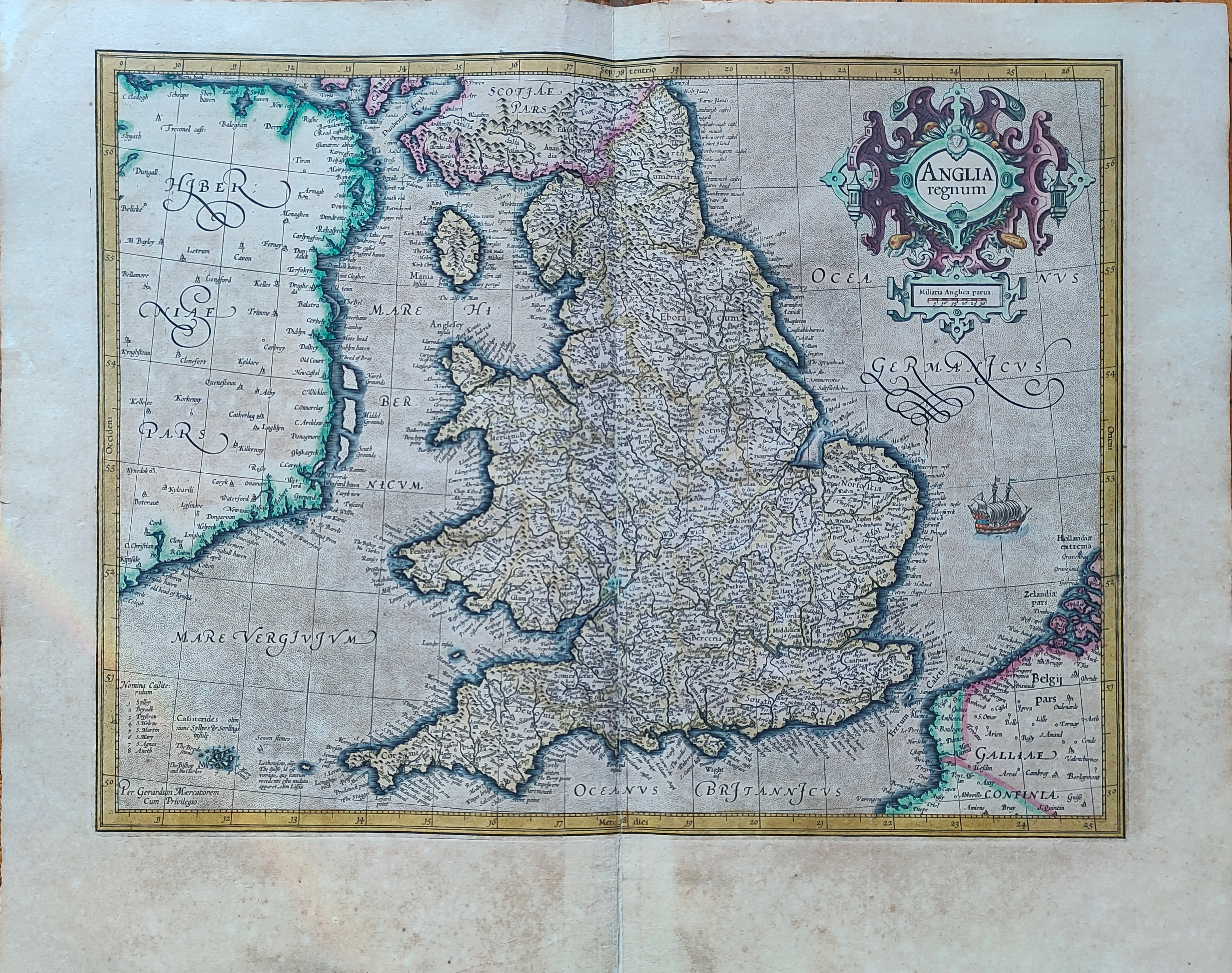
Map title
Anglia regnum
Author
Mercator
Location shown in map
England
Edition date
Circa 1623
Edition place
Amsterdam
Editor
Houndius
Atlas
Mercator-Hondius Atlas.
Price
400 Euro
State
[mint/EXCELLENT/very good/good/fair/mediocre/poor]
Color
Old colors
Verso
Franch text 117
Size
Plate: cm (46 x 36) inches (18.11 x 14.17) Paper: cm (56 x 44) inches (22.05 x 17.32)
Technique
Copper engraving
Note
Reference
Wiki
Here for more info
In stock
Available
Info
info@thetreasuremaps.com
Code
#1195
×
![Anglia regnum by Mercator, England, Circa 1623]()
Map title
Abissinorum regnum
Author
Mercator
Location shown in map
East Africa
Edition date
1625
Edition place
London
Editor
--
Atlas
Purchas his Pilgrimes
Price
250 Euro
State
[mint/EXCELLENT/very good/good/fair/mediocre/poor]
Color
Modern colors
Verso
English text
Size
Plate: cm (17.8 x 14) inches (7.01 x 5.51) Paper: cm (21.6 x 33) inches (8.5 x 12.99)
Technique
Copper engraving
Note
No particular notes for this maps
Reference
--
Wiki
Here for more info
In stock
Available
Info
info@thetreasuremaps.com
Code
#0293
×
![Abissinorum regnum by Mercator, East Africa, 1625]()
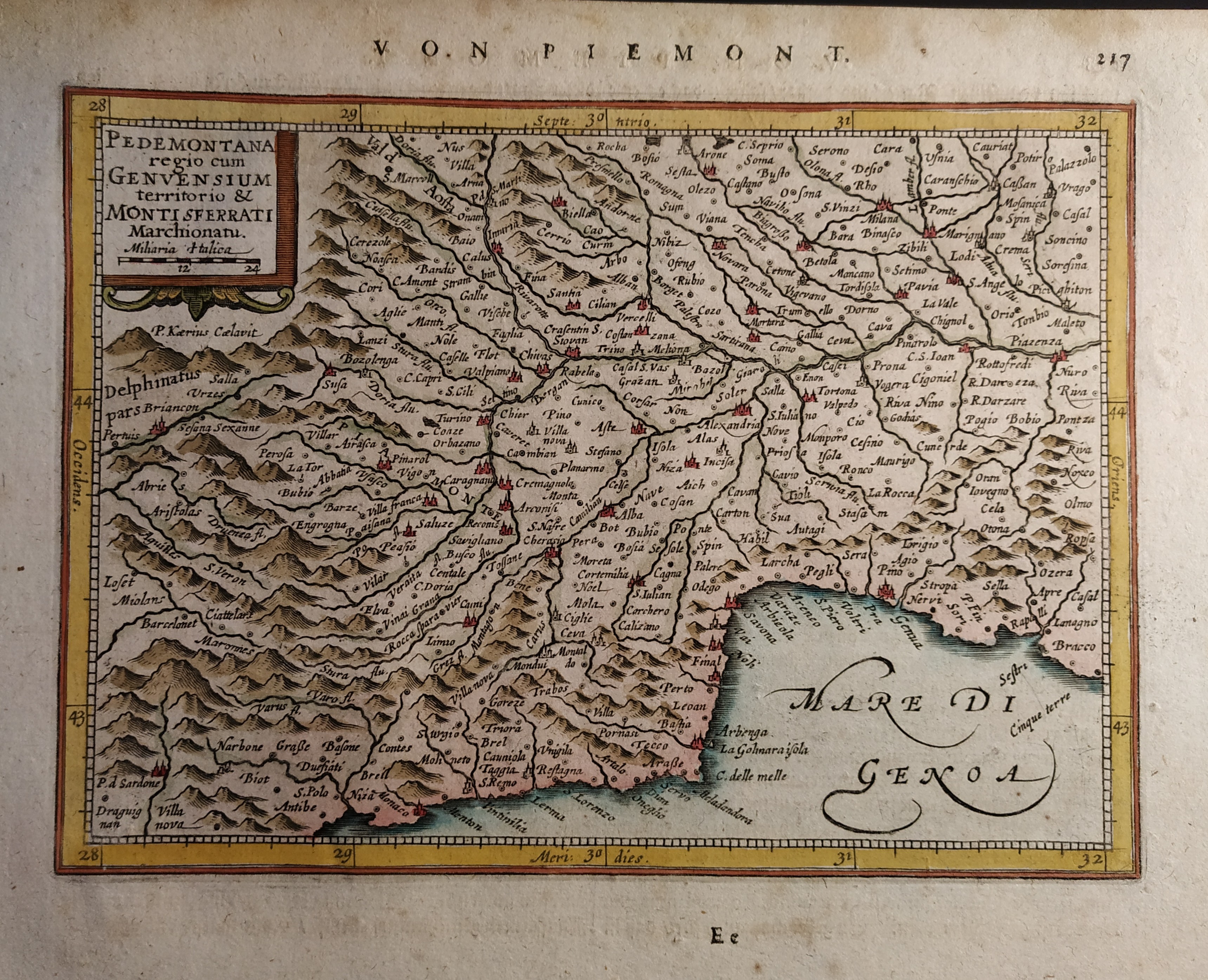
Map title
Pedemontana regio cum Genvensium territorio & Montisferrati marchionatu
Author
Mercator
Location shown in map
North-West Italy
Edition date
Circa 1628
Edition place
Amsterdam
Editor
Janssonius
Atlas
Altas Minor Gerardi Mercatoris
Price
150 Euro
State
[mint/EXCELLENT/very good/good/fair/mediocre/poor]
Color
Old colors
Verso
German text pag 218
Size
Plate: cm (19 x 14) inches (7.48 x 5.51) Paper: cm (23 x 19) inches (9.06 x 7.48)
Technique
Copper engraving
Note
No particular notes for this maps.
Reference
Wiki
Here for more info
In stock
Available
Info
info@thetreasuremaps.com
Code
#0660
×
![Pedemontana regio cum Genvensium territorio & Montisferrati marchionatu by Mercator, North-West Italy, Circa 1628]()
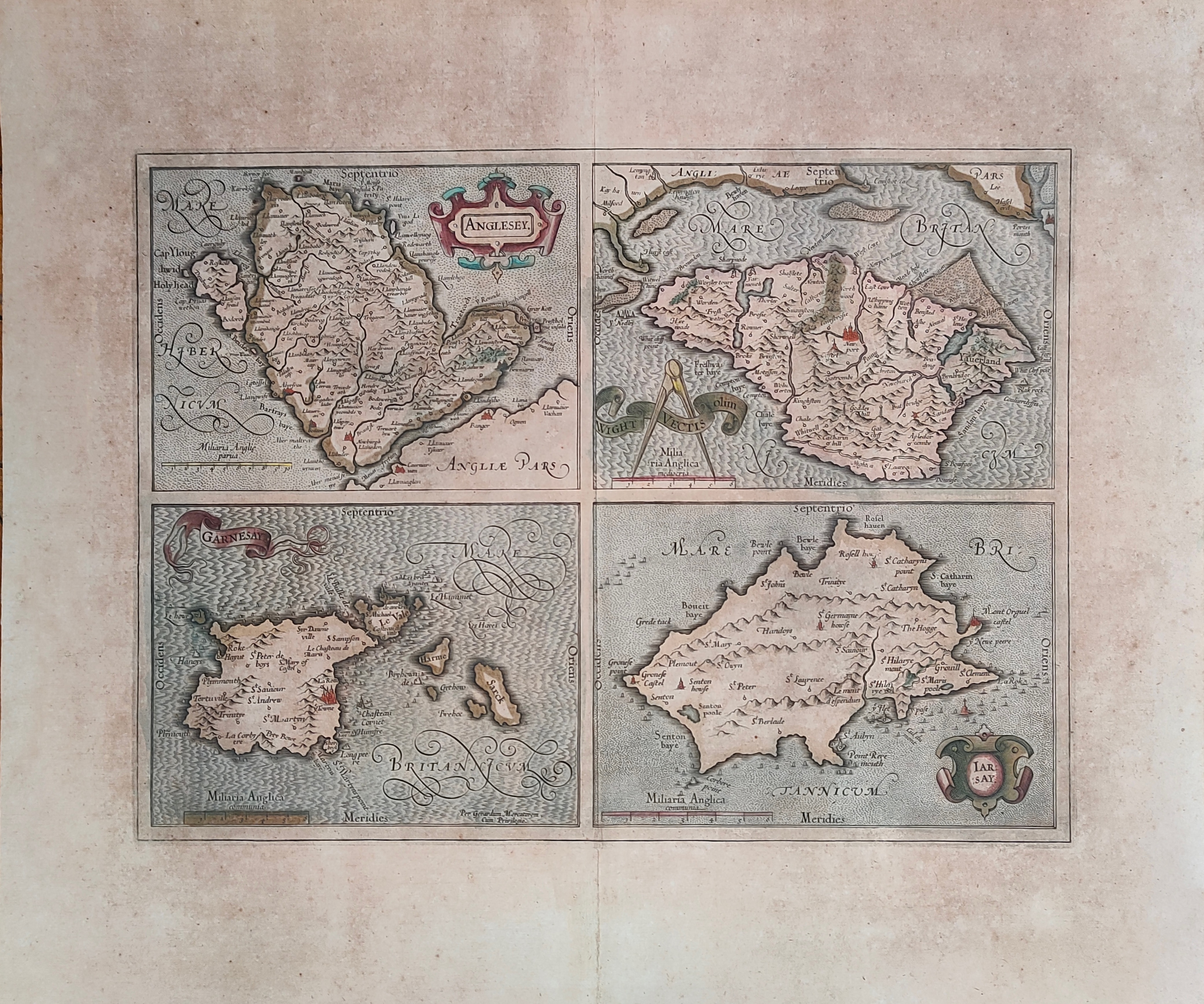
Map title
Anglesey, Garnesay, Wight olim Vectis, Iarsay
Author
Mercator
Location shown in map
Wight
Edition date
Circa 1628
Edition place
Amsterdam
Editor
Houndius
Atlas
Mercator-Hondius Atlas.
Price
250 Euro
State
[mint/EXCELLENT/very good/good/fair/mediocre/poor]
Color
Old colors
Verso
Latin text
Size
Plate: cm (42 x 32) inches (16.54 x 12.6) Paper: cm (55 x 47) inches (21.65 x 18.5)
Technique
Copper engraving
Note
Professionally repaired
Reference
Wiki
Here for more info
In stock
Available
Info
info@thetreasuremaps.com
Code
#1232
×
![Anglesey, Garnesay, Wight olim Vectis, Iarsay by Mercator, Wight, Circa 1628]()
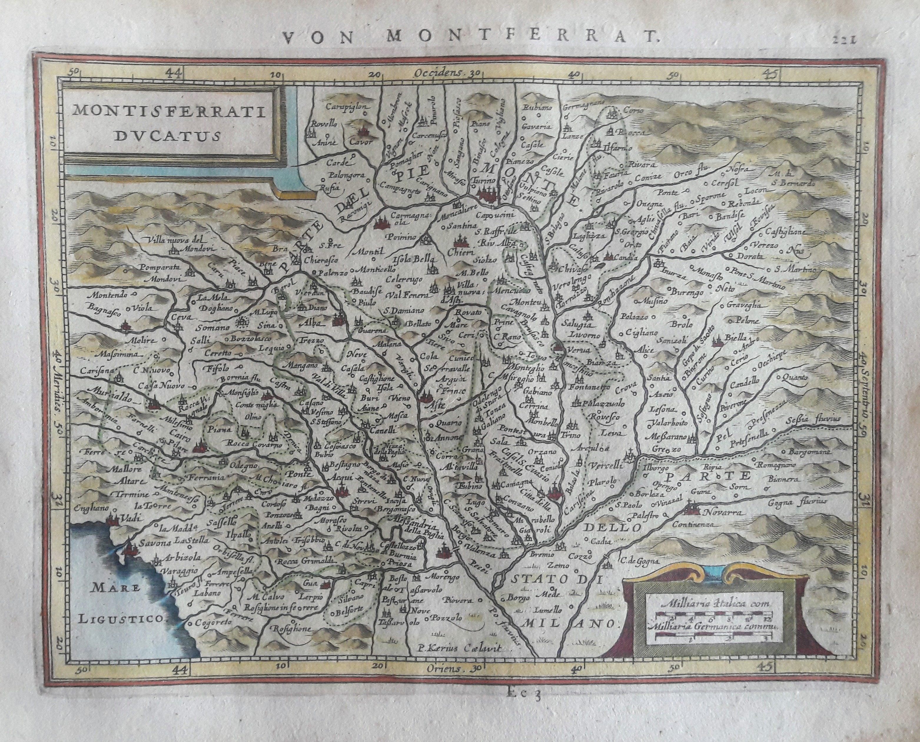
Map title
Montisferrati Ducatus
Author
Mercator
Location shown in map
North-West Italy
Edition date
Circa 1628
Edition place
Amsterdam
Editor
Janssonius
Atlas
Altas Minor Gerardi Mercatoris
Price
150 Euro
State
[mint/EXCELLENT/very good/good/fair/mediocre/poor]
Color
Old colors
Verso
German text 222
Size
Plate: cm (20 x 15) inches (7.87 x 5.91) Paper: cm (23 x 19) inches (9.06 x 7.48)
Technique
Copper engraving
Note
No particular notes for this maps.
Reference
Wiki
Here for more info
In stock
Available
Info
info@thetreasuremaps.com
Code
#0661
×
![Montisferrati Ducatus by Mercator, North-West Italy, Circa 1628]()
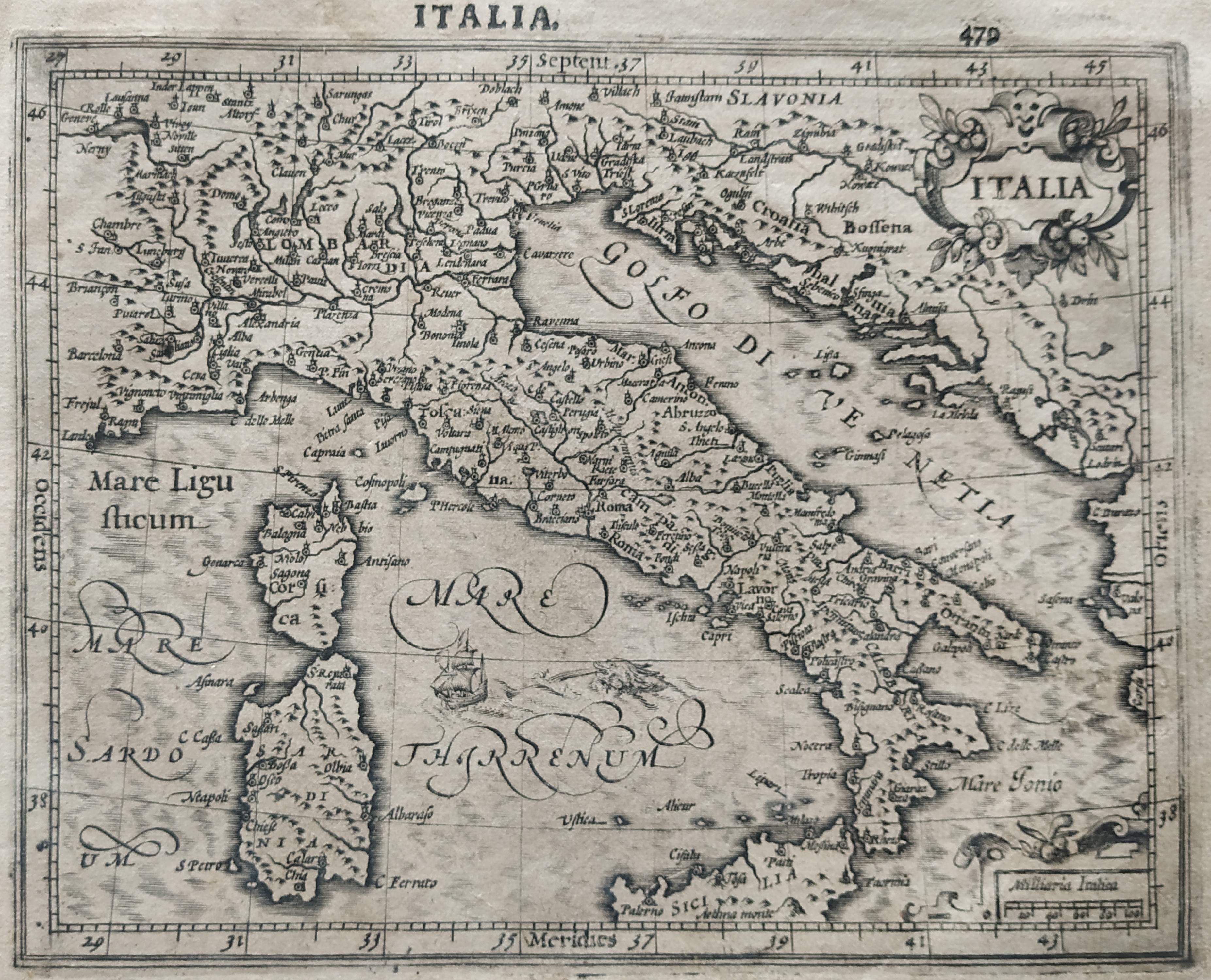
Map title
Italia
Author
Mercator
Location shown in map
Italy
Edition date
1630
Edition place
Amsterdam
Editor
Houndius
Atlas
Mercator-Hondius Atlas.
Price
900 Euro
State
[mint/EXCELLENT/very good/good/fair/mediocre/poor]
Color
Black/white
Verso
Latin text 299
Size
Plate: cm (46 x 36) inches (18.11 x 14.17) Paper: cm (57 x 47) inches (22.44 x 18.5)
Technique
Copper engraving
Note
Reference
R.Borri L'Italia nelle antiche carte pag.92
Wiki
Here for more info
In stock
Available
Info
info@thetreasuremaps.com
Code
#0790
×
![Italia by Mercator, Italy, 1630]()
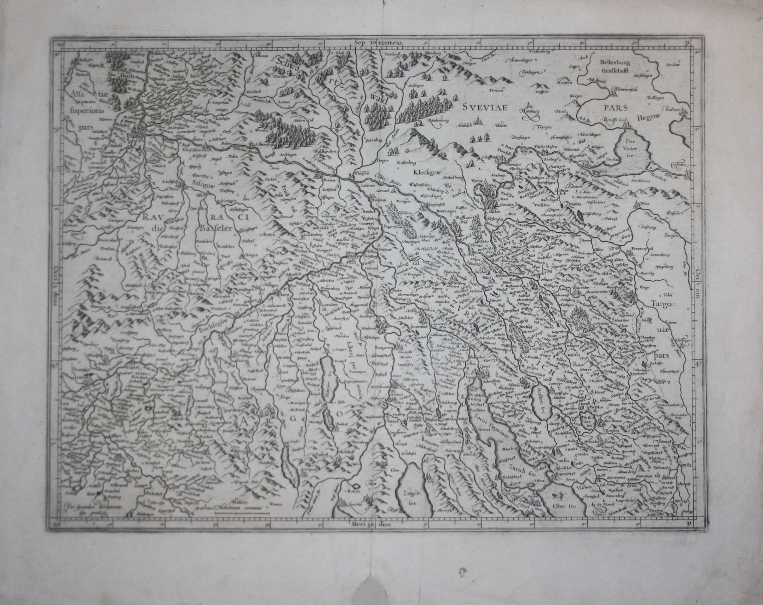
Map title
--
Author
Mercator
Location shown in map
Switzerland
Edition date
Circa 1630
Edition place
--
Editor
--
Atlas
--
Price
200 Euro
State
[mint/excellent/VERY GOOD/good/fair/mediocre/poor]
Color
Black/white
Verso
Latin text pag.182
Size
Plate: cm (47 x 35.6) inches (18.5 x 14.02) Paper: cm (55.9 x 45.7) inches (22.01 x 17.99)
Technique
Copper engraving
Note
Reference
--
Wiki
Here for more info
In stock
Available
Info
info@thetreasuremaps.com
Code
#0505
--
Author
Mercator
Location shown in map
Switzerland
Edition date
Circa 1630
Edition place
--
Editor
--
Atlas
--
Price
200 Euro
State
[mint/excellent/VERY GOOD/good/fair/mediocre/poor]
Color
Black/white
Verso
Latin text pag.182
Size
Plate: cm (47 x 35.6) inches (18.5 x 14.02) Paper: cm (55.9 x 45.7) inches (22.01 x 17.99)
Technique
Copper engraving
Note
Reference
--
Wiki
Here for more info
In stock
Available
Info
info@thetreasuremaps.com
Code
#0505
×
![-- by Mercator, Switzerland, Circa 1630]()
Map title
--
Author
Mercator
Location shown in map
Switzerland
Edition date
Circa 1630
Edition place
--
Editor
--
Atlas
--
Price
200 Euro
State
[mint/excellent/VERY GOOD/good/fair/mediocre/poor]
Color
Black/white
Verso
Blank
Size
Plate: cm (47 x 35.6) inches (18.5 x 14.02) Paper: cm (53.3 x 40.6) inches (20.98 x 15.98)
Technique
Copper engraving
Note
Reference
--
Wiki
Here for more info
In stock
Available
Info
info@thetreasuremaps.com
Code
#0504
--
Author
Mercator
Location shown in map
Switzerland
Edition date
Circa 1630
Edition place
--
Editor
--
Atlas
--
Price
200 Euro
State
[mint/excellent/VERY GOOD/good/fair/mediocre/poor]
Color
Black/white
Verso
Blank
Size
Plate: cm (47 x 35.6) inches (18.5 x 14.02) Paper: cm (53.3 x 40.6) inches (20.98 x 15.98)
Technique
Copper engraving
Note
Reference
--
Wiki
Here for more info
In stock
Available
Info
info@thetreasuremaps.com
Code
#0504
×
![-- by Mercator, Switzerland, Circa 1630]()
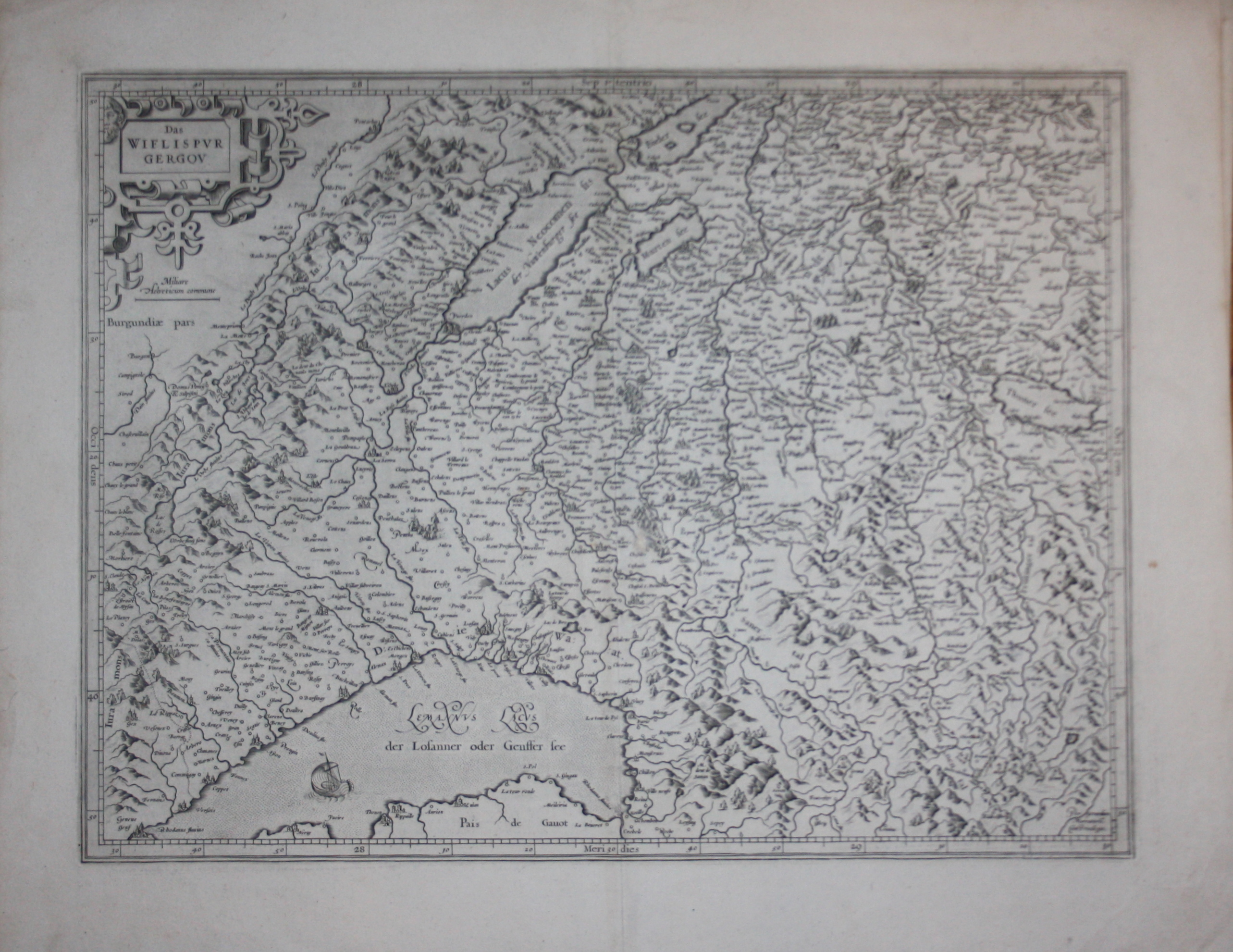
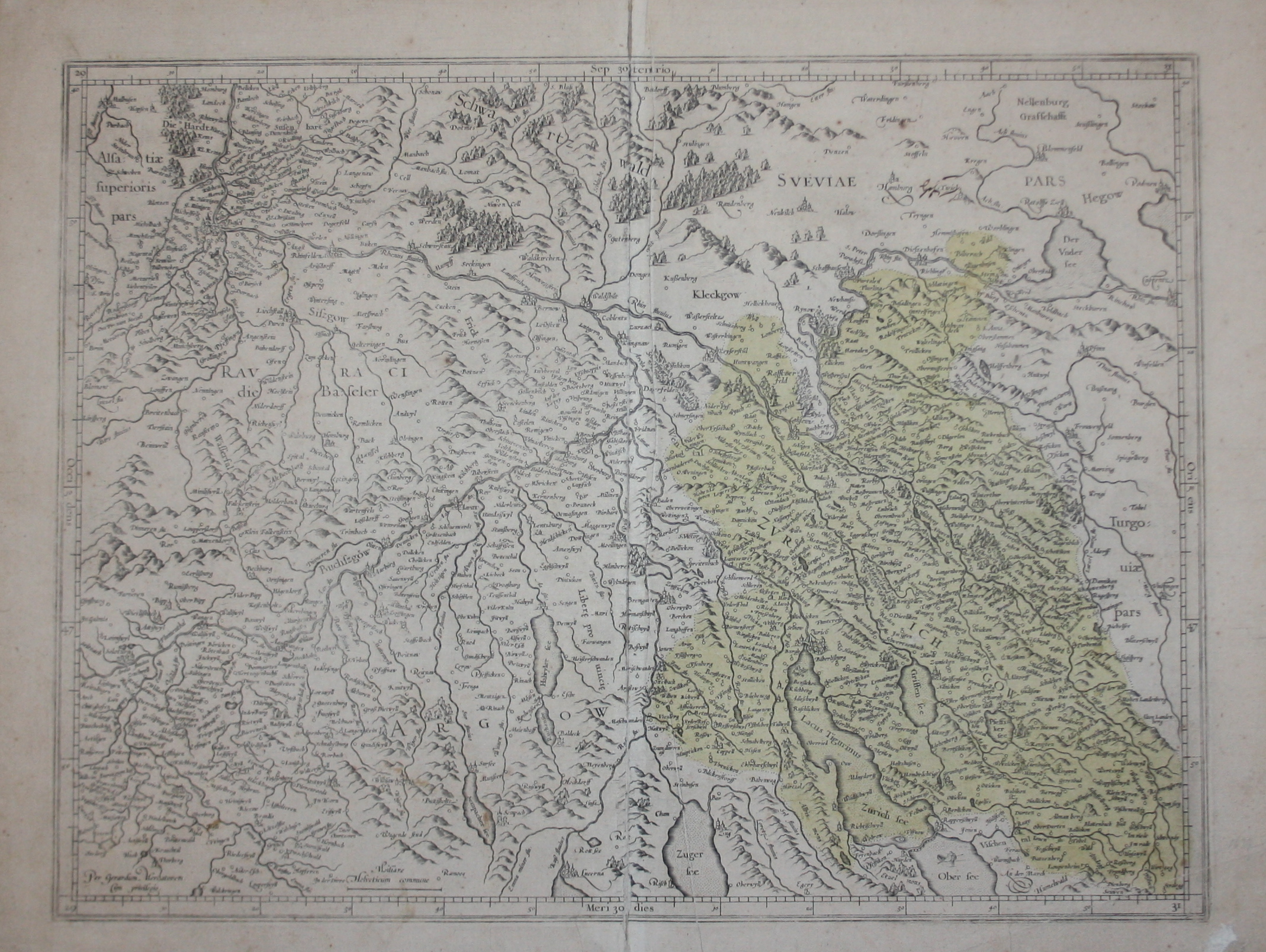
Map title
Das Wiflispvrgergow
Author
Mercator
Location shown in map
Switzerland
Edition date
Circa 1630
Edition place
--
Editor
--
Atlas
--
Price
200 Euro
State
[mint/excellent/VERY GOOD/good/fair/mediocre/poor]
Color
Black/white
Verso
Latin text pag.184
Size
Plate: cm (47 x 35.6) inches (18.5 x 14.02) Paper: cm (57.2 x 43.2) inches (22.52 x 17.01)
Technique
Copper engraving
Note
Reference
--
Wiki
Here for more info
In stock
Available
Info
info@thetreasuremaps.com
Code
#0503
×
![Das Wiflispvrgergow by Mercator, Switzerland, Circa 1630]()
Map title
Abbruzzo
Author
Mercator
Location shown in map
Abruzzo
Edition date
1632
Edition place
Amsterdam
Editor
Houndius
Atlas
Altas de novo plurimis in locis
Price
200 Euro
State
[mint/EXCELLENT/very good/good/fair/mediocre/poor]
Color
Black/white
Verso
Latin text 616
Size
Plate: cm (25 x 19) inches (9.84 x 7.48) Paper: cm (28 x 22) inches (11.02 x 8.66)
Technique
Copper engraving
Note
Reference
Ex ipso Atlante
Wiki
Here for more info
In stock
Available
Info
info@thetreasuremaps.com
Code
#1354
×
![Abbruzzo by Mercator, Abruzzo, 1632]()
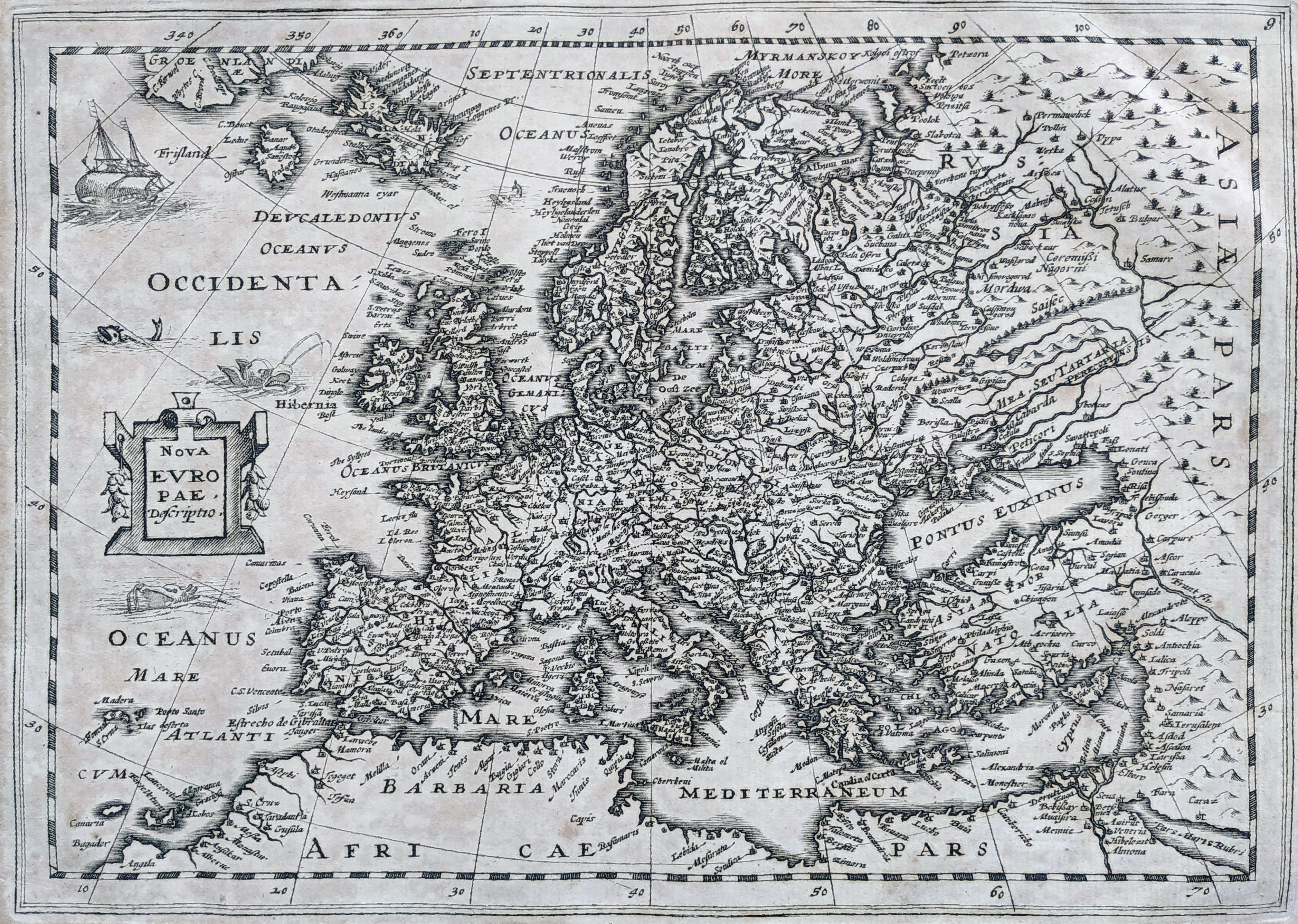
Map title
Nova Europae descriptio
Author
Mercator
Location shown in map
Europe
Edition date
1632
Edition place
Amsterdam
Editor
Hondius
Atlas
Atlas sive Cosmographicae Meditationes de Fabrica Mundi et fabricati figura
Price
300 Euro
State
[mint/EXCELLENT/very good/good/fair/mediocre/poor]
Color
Black/white
Verso
Blank
Size
Plate: cm (25 x 19) inches (9.84 x 7.48) Paper: cm (40 x 26) inches (15.75 x 10.24)
Technique
Copper engraving
Note
No particular notes for this maps.
Reference
Wiki
Here for more info
In stock
Available
Info
info@thetreasuremaps.com
Code
#0808
×
![Nova Europae descriptio by Mercator, Europe, 1632]()

Map title
Pedemontana regio cum Genvensium territorio & Montisferrati marchionatu
Author
Mercator
Location shown in map
Liguria
Edition date
Circa 1633
Edition place
Amsterdam
Editor
Houndius
Atlas
Mercator-Hondius Atlas.
Price
400 Euro
State
[mint/EXCELLENT/very good/good/fair/mediocre/poor]
Color
Black/white
Verso
Franch text pag 545
Size
Plate: cm (44 x 35) inches (17.32 x 13.78) Paper: cm (54 x 45) inches (21.26 x 17.72)
Technique
Copper engraving
Note
No particular notes for this maps
Reference
--
Wiki
Here for more info
In stock
Available
Info
info@thetreasuremaps.com
Code
#0020
×
![Pedemontana regio cum Genvensium territorio & Montisferrati marchionatu by Mercator, Liguria, Circa 1633]()
Pages: 1 2