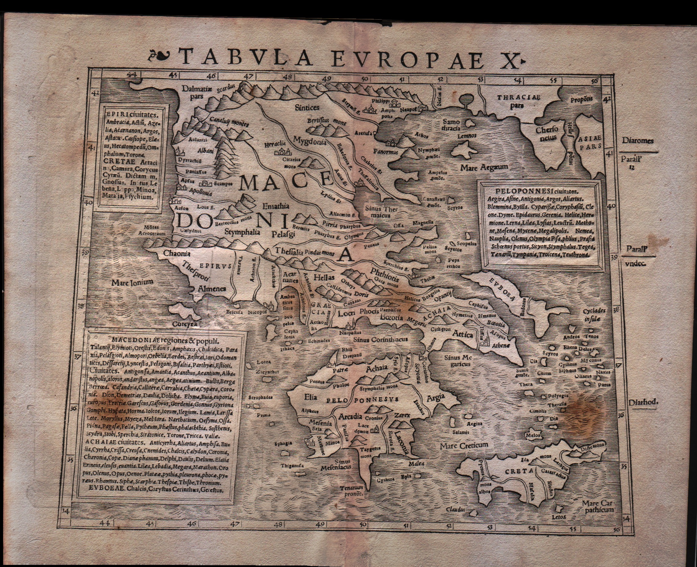
Munster
Map title
Tabula Europae X
Author
Munster
Location shown in map
Greece
Edition date
1540
Edition place
Basel
Editor
Henrich Petri
Atlas
Geographia
Price
300 Euro
State
[mint/EXCELLENT/very good/good/fair/mediocre/poor]
Color
Black/white
Verso
Latin text pag.12
Size
Plate: cm (31.8 x 25.4) inches (12.52 x 10) Paper: cm (38.1 x 30.5) inches (15 x 12.01)
Technique
Woodcut
Note
No particular notes for this maps
Reference
--
Wiki
Here for more info
In stock
Available
Info
info@thetreasuremaps.com
Code
#0093
×
![]()
Map title
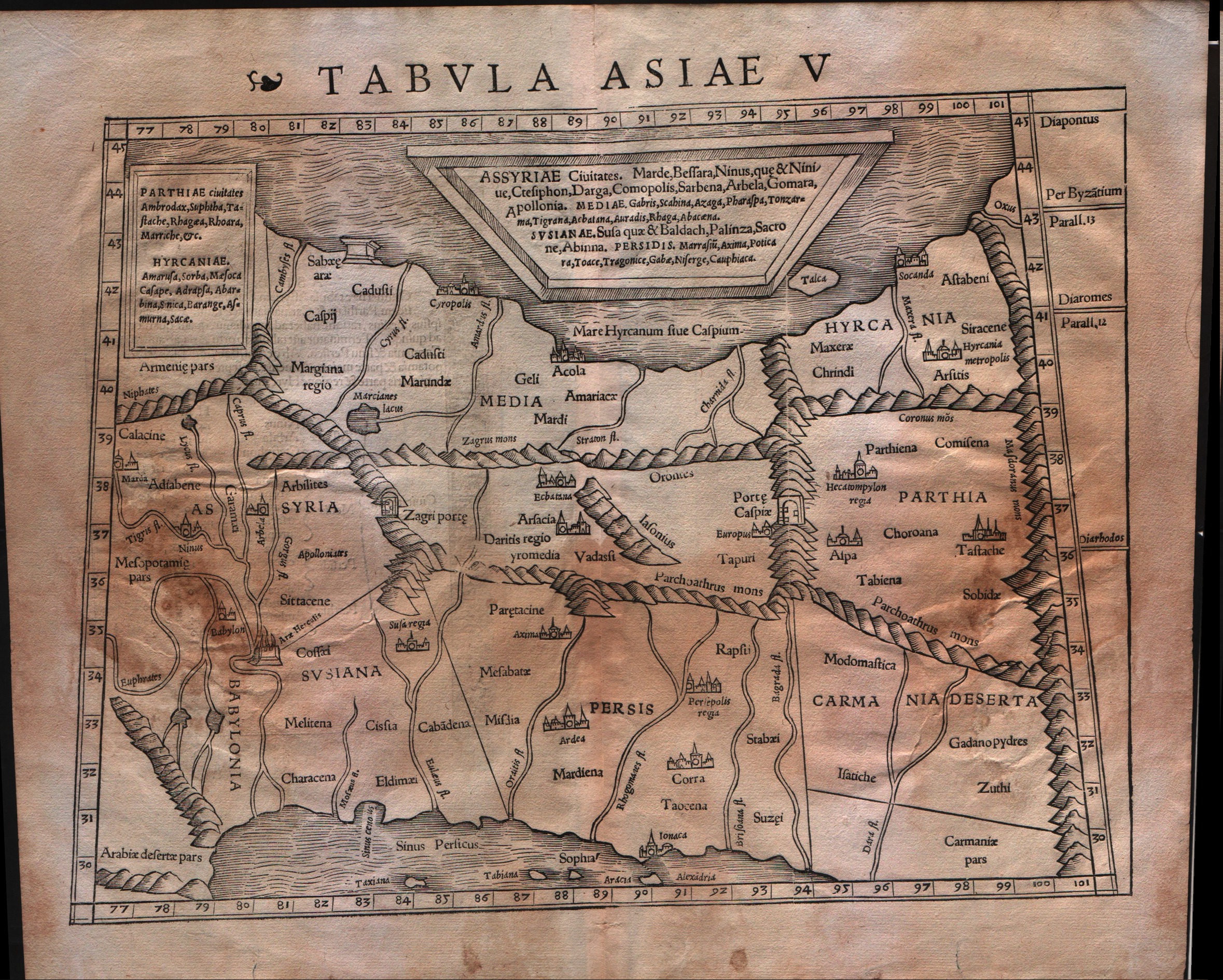
Tabula Asiae V
Author
Munster
Location shown in map
Iran and Iraq
Edition date
1540
Edition place
Basel
Editor
Henrich Petri
Atlas
Geographia
Price
300 Euro
State
[mint/EXCELLENT/very good/good/fair/mediocre/poor]
Color
Black/white
Verso
Latin text pag.21
Size
Plate: cm (34.3 x 25.4) inches (13.5 x 10) Paper: cm (38.1 x 30.5) inches (15 x 12.01)
Technique
Woodcut
Note
Ptolemaic map of the region between the Caspian Sea and the Persian Gulf. Numerous ancient cities including Babylon.
Reference
--
Wiki
Here for more info
In stock
Available
Info
info@thetreasuremaps.com
Code
#0175
×
![]()
Map title
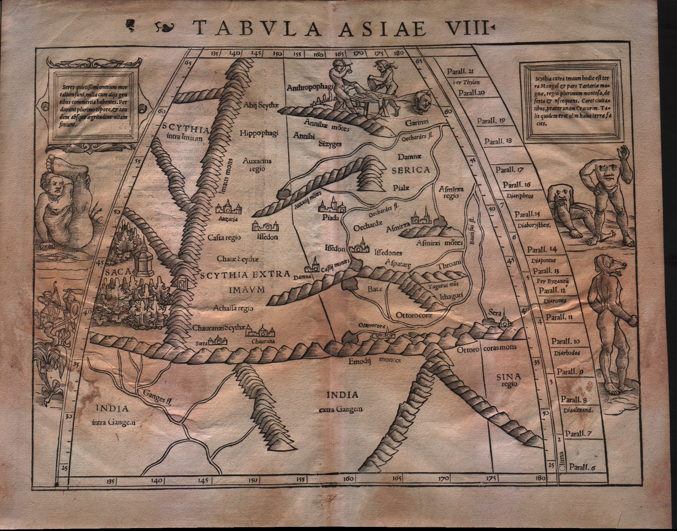
Tabula Asiae VIII
Author
Munster
Location shown in map
Central Asia
Edition date
1540
Edition place
Basel
Editor
Henrich Petri
Atlas
Geographia
Price
600 Euro
State
[mint/EXCELLENT/very good/good/fair/mediocre/poor]
Color
Black/white
Verso
Latin text pag.24
Size
Plate: cm (34.3 x 25.4) inches (13.5 x 10) Paper: cm (38.1 x 30.5) inches (15 x 12.01)
Technique
Woodcut
Note
Central Asia North of India. Showing in the margin on either side three different imaginary human congenital malformations, as well as a one legged bird.
Reference
--
Wiki
Here for more info
In stock
Available
Info
info@thetreasuremaps.com
Code
#0174
×
![]()

Map title
Hispania Nova Tabula
Author
Munster
Location shown in map
Spain
Edition date
1542
Edition place
Basel
Editor
Henrich Petri
Atlas
Geographia
Price
Please ask: info@thetreasuremaps.com
State
[mint/excellent/VERY GOOD/good/fair/mediocre/poor]
Color
Original colors
Verso
Latin text pag.31
Size
Plate: cm (34.3 x 25.4) inches (13.5 x 10) Paper: cm (38.1 x 30.5) inches (15 x 12.01)
Technique
Woodcut
Note
No particular notes for this maps
Reference
--
Wiki
Here for more info
In stock
Sold
Info
info@thetreasuremaps.com
Code
#0092
×
![]()
Map title
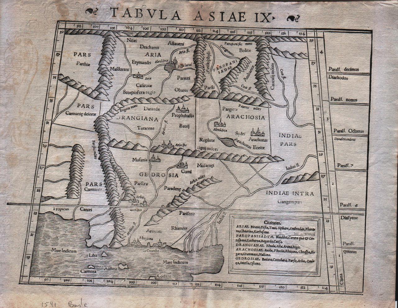
Tabula Asiae IX
Author
Munster
Location shown in map
Pakistan
Edition date
1542
Edition place
Basel
Editor
Henrich Petri
Atlas
Geographia
Price
250 Euro
State
[mint/excellent/VERY GOOD/good/fair/mediocre/poor]
Color
Black/white
Verso
Latin text pag.21
Size
Plate: cm (33 x 25.4) inches (12.99 x 10) Paper: cm (38.1 x 30.5) inches (15 x 12.01)
Technique
Woodcut
Note
Ptolemaic map of the region between the Caspian Sea and the Persian Gulf. Numerous ancient cities including Babylon.
Reference
--
Wiki
Here for more info
In stock
Available
Info
info@thetreasuremaps.com
Code
#0176
×
![]()
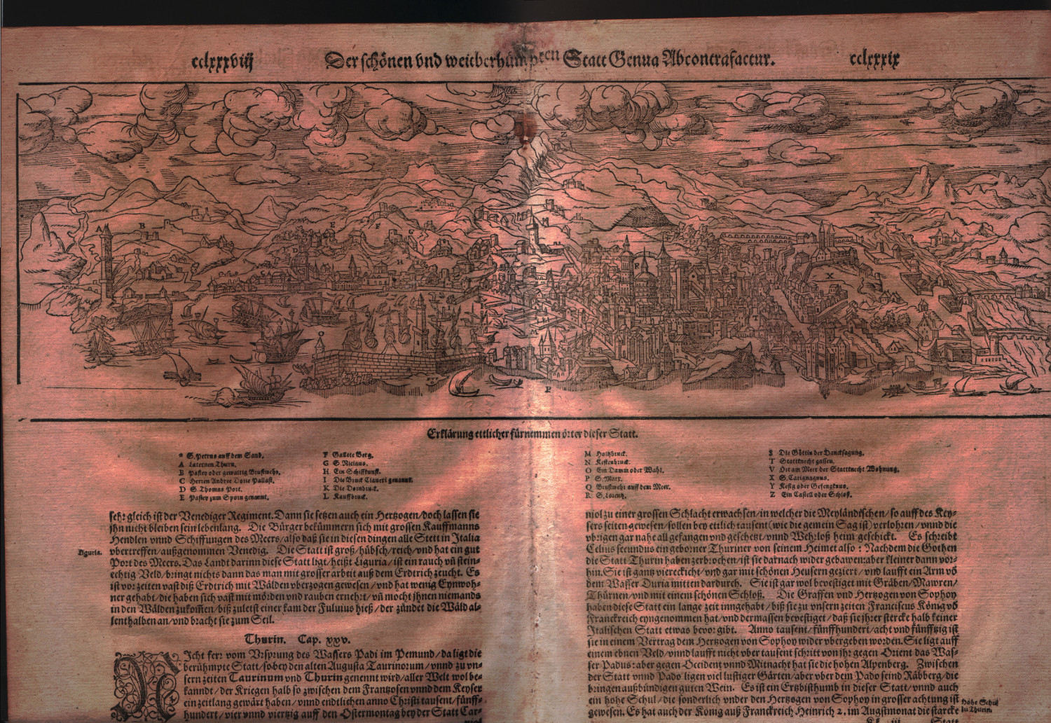
Map title
--
Author
Munster
Location shown in map
Italy
Edition date
1542
Edition place
Basel
Editor
Henrich Petri
Atlas
Geographia Universalis
Price
700 Euro
State
[mint/EXCELLENT/very good/good/fair/mediocre/poor]
Color
Black/white
Verso
Latin text pag.43
Size
Plate: cm (33 x 25) inches (12.99 x 9.84) Paper: cm (40 x 32) inches (15.75 x 12.6)
Technique
Woodcut
Note
Reference
R.Borri L'Italia nelle antiche carte pag.50
Wiki
Here for more info
In stock
Available
Info
info@thetreasuremaps.com
Code
#0933
×
![]()
Map title
Aphricae Tabula III
Author
Munster
Location shown in map
Egypt
Edition date
1545
Edition place
Basel
Editor
Henrich Petri
Atlas
Cosmographia Universalis
Price
200 Euro
State
[mint/EXCELLENT/very good/good/fair/mediocre/poor]
Color
Black/white
Verso
Latin text pag.15
Size
Plate: cm (34.3 x 25.4) inches (13.5 x 10) Paper: cm (38.1 x 30.5) inches (15 x 12.01)
Technique
Woodcut
Note
--
Reference
--
Wiki
Here for more info
In stock
Sold
Info
info@thetreasuremaps.com
Code
#0507
×
![]()
Map title
Tabula Europae VIII
Author
Munster
Location shown in map
Russia
Edition date
1545
Edition place
Basel
Editor
Henrich Petri
Atlas
Cosmographia Universalis
Price
Please ask: info@thetreasuremaps.com
State
[mint/excellent/VERY GOOD/good/fair/mediocre/poor]
Color
Black/white
Verso
Latin text pag.10
Size
Plate: cm (33 x 25.4) inches (12.99 x 10) Paper: cm (40.6 x 30.5) inches (15.98 x 12.01)
Technique
Woodcut
Note
No particular notes for this maps
Reference
--
Wiki
Here for more info
In stock
Sold
Info
info@thetreasuremaps.com
Code
#0094
×
![]()
Map title
Sclavonia oder Windisch Marck Bossen Crabaten ...
Author
Munster
Location shown in map
Slovenia,Kroatia,Bosnia,Triest
Edition date
Unknown
Edition place
Basel
Editor
Henrich Petri
Atlas
Cosmographia Universalis
Price
200 Euro
State
[mint/EXCELLENT/very good/good/fair/mediocre/poor]
Color
Black/white
Verso
German text pag.???
Size
Plate: cm (34.3 x 25.4) inches (13.5 x 10) Paper: cm (40.6 x 31.8) inches (15.98 x 12.52)
Technique
Woodcut
Note
--
Reference
--
Wiki
Here for more info
In stock
Available
Info
info@thetreasuremaps.com
Code
#0113
×
![]()
Map title
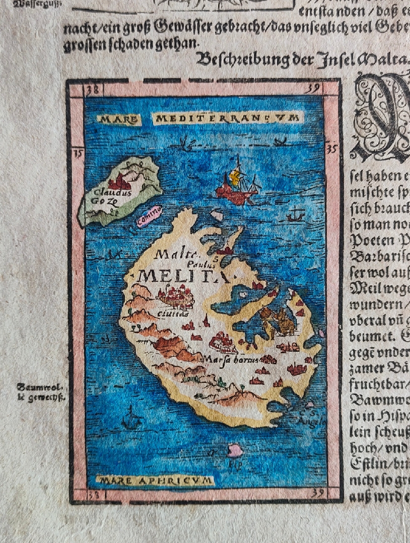
Malta
Author
Munster
Location shown in map
Malta
Edition date
Circa 1550
Edition place
Basel
Editor
Henrich Petri
Atlas
Cosmographia Universalis
Price
200 Euro
State
[mint/EXCELLENT/very good/good/fair/mediocre/poor]
Color
Old colors
Verso
German text pag.613
Size
Plate: cm (24 x 36) inches (9.45 x 14.17) Paper: cm (8 x 12) inches (3.15 x 4.72)
Technique
Woodcut
Note
Reference
Wiki
Here for more info
In stock
Available
Info
info@thetreasuremaps.com
Code
#0843
Malta
Author
Munster
Location shown in map
Malta
Edition date
Circa 1550
Edition place
Basel
Editor
Henrich Petri
Atlas
Cosmographia Universalis
Price
200 Euro
State
[mint/EXCELLENT/very good/good/fair/mediocre/poor]
Color
Old colors
Verso
German text pag.613
Size
Plate: cm (24 x 36) inches (9.45 x 14.17) Paper: cm (8 x 12) inches (3.15 x 4.72)
Technique
Woodcut
Note
Reference
Wiki
Here for more info
In stock
Available
Info
info@thetreasuremaps.com
Code
#0843
×
![]()
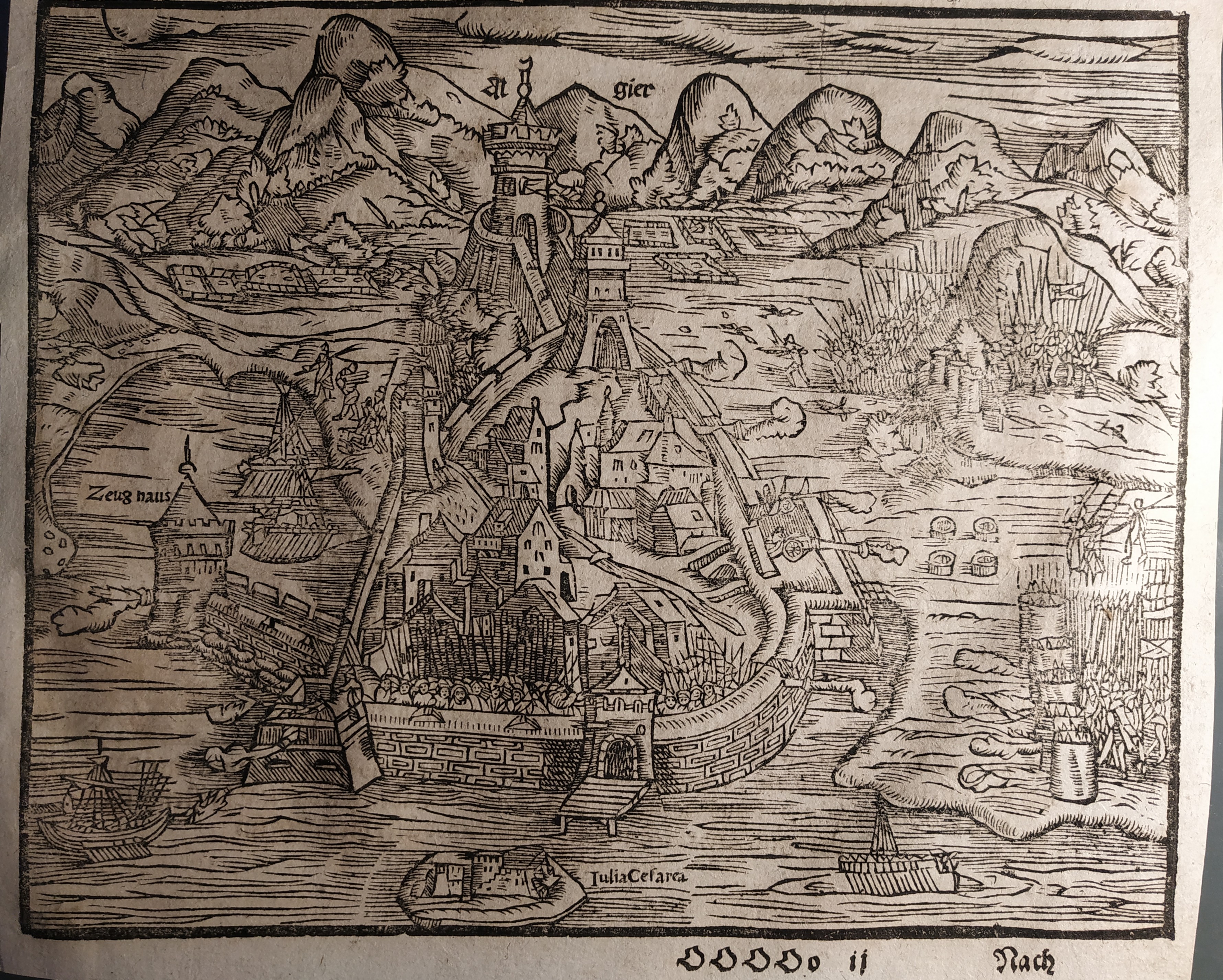
Map title
Algiers
Author
Munster
Location shown in map
Algiers
Edition date
Circa 1550
Edition place
Basel
Editor
Henrich Petri
Atlas
Cosmographia Universalis
Price
Please ask: info@thetreasuremaps.com
State
[mint/EXCELLENT/very good/good/fair/mediocre/poor]
Color
Black/white
Verso
German text
Size
Plate: cm (11 x 15) inches (4.33 x 5.91) Paper: cm (13 x 21) inches (5.12 x 8.27)
Technique
Woodcut
Note
No particular notes for this maps
Reference
Wiki
Here for more info
In stock
Available
Info
info@thetreasuremaps.com
Code
#0739
Algiers
Author
Munster
Location shown in map
Algiers
Edition date
Circa 1550
Edition place
Basel
Editor
Henrich Petri
Atlas
Cosmographia Universalis
Price
Please ask: info@thetreasuremaps.com
State
[mint/EXCELLENT/very good/good/fair/mediocre/poor]
Color
Black/white
Verso
German text
Size
Plate: cm (11 x 15) inches (4.33 x 5.91) Paper: cm (13 x 21) inches (5.12 x 8.27)
Technique
Woodcut
Note
No particular notes for this maps
Reference
Wiki
Here for more info
In stock
Available
Info
info@thetreasuremaps.com
Code
#0739
×
![]()
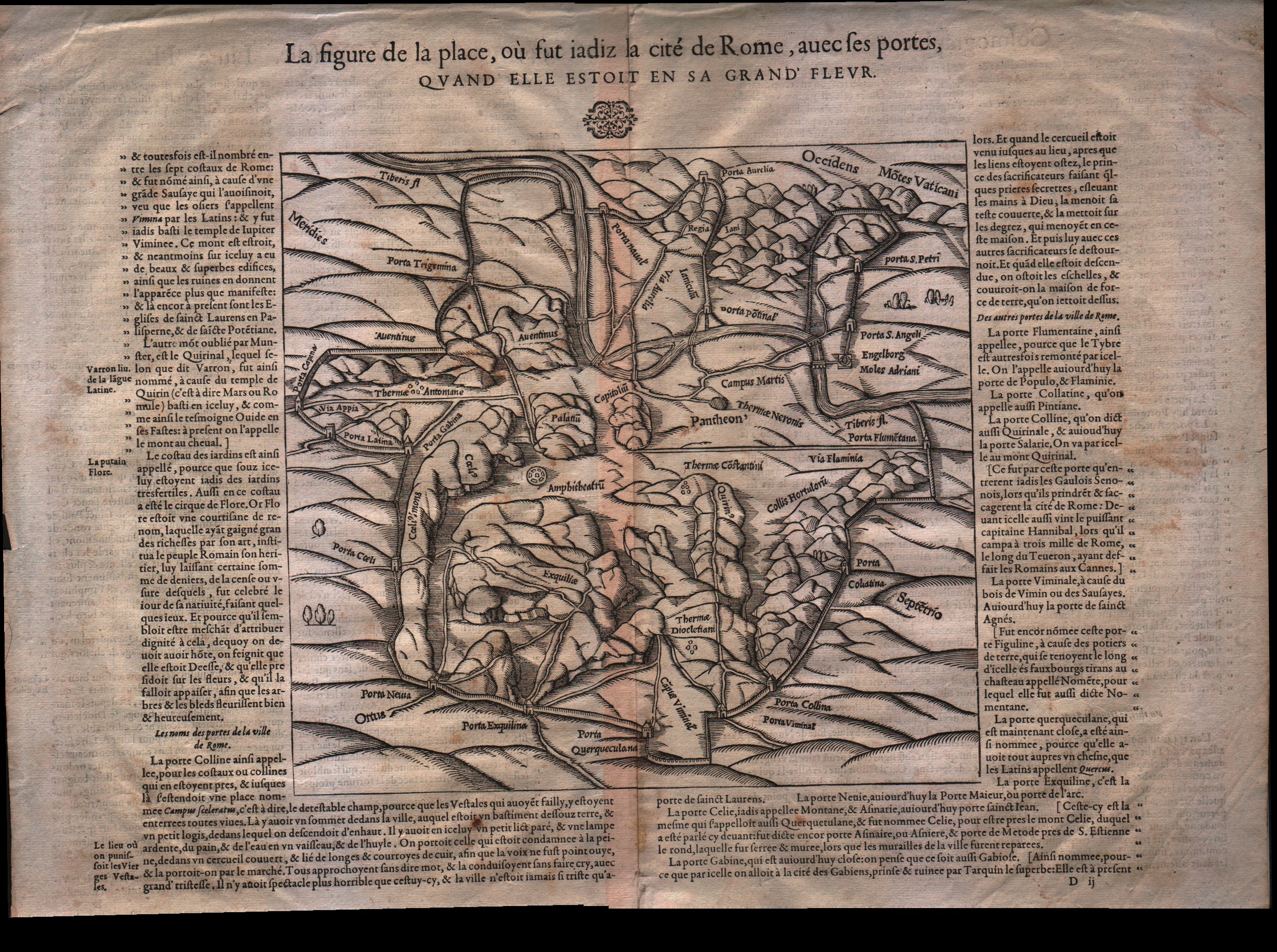
Map title
La figure de la place de Rome...
Author
Munster
Location shown in map
Rome
Edition date
1550
Edition place
Basel
Editor
Henrich Petri
Atlas
Cosmographia Universalis
Price
200 Euro
State
[mint/EXCELLENT/very good/good/fair/mediocre/poor]
Color
Black/white
Verso
French text pag.550
Size
Plate: cm (22.9 x 21.6) inches (9.02 x 8.5) Paper: cm (41.9 x 34.3) inches (16.5 x 13.5)
Technique
Woodcut
Note
No particular notes for this maps
Reference
--
Wiki
Here for more info
In stock
Available
Info
info@thetreasuremaps.com
Code
#0095
×
![]()
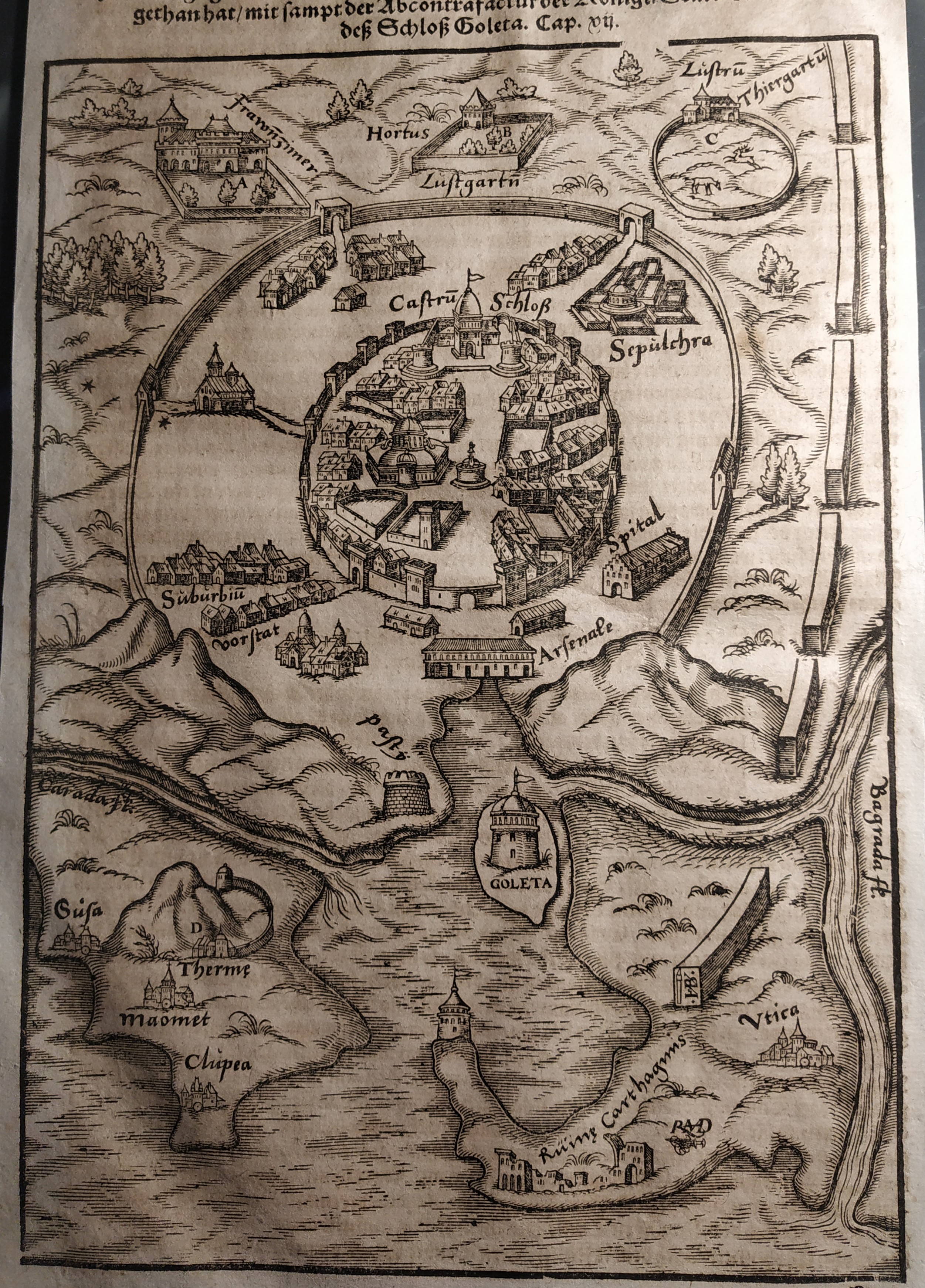
Map title
Goleta
Author
Munster
Location shown in map
Tunis
Edition date
Circa 1550
Edition place
Basel
Editor
Henrich Petri
Atlas
Cosmographia Universalis
Price
Please ask: info@thetreasuremaps.com
State
[mint/EXCELLENT/very good/good/fair/mediocre/poor]
Color
Black/white
Verso
German text
Size
Plate: cm (17 x 24) inches (6.69 x 9.45) Paper: cm (18 x 30) inches (7.09 x 11.81)
Technique
Woodcut
Note
No particular notes for this maps
Reference
Wiki
Here for more info
In stock
Available
Info
info@thetreasuremaps.com
Code
#0738
×
![]()
Map title
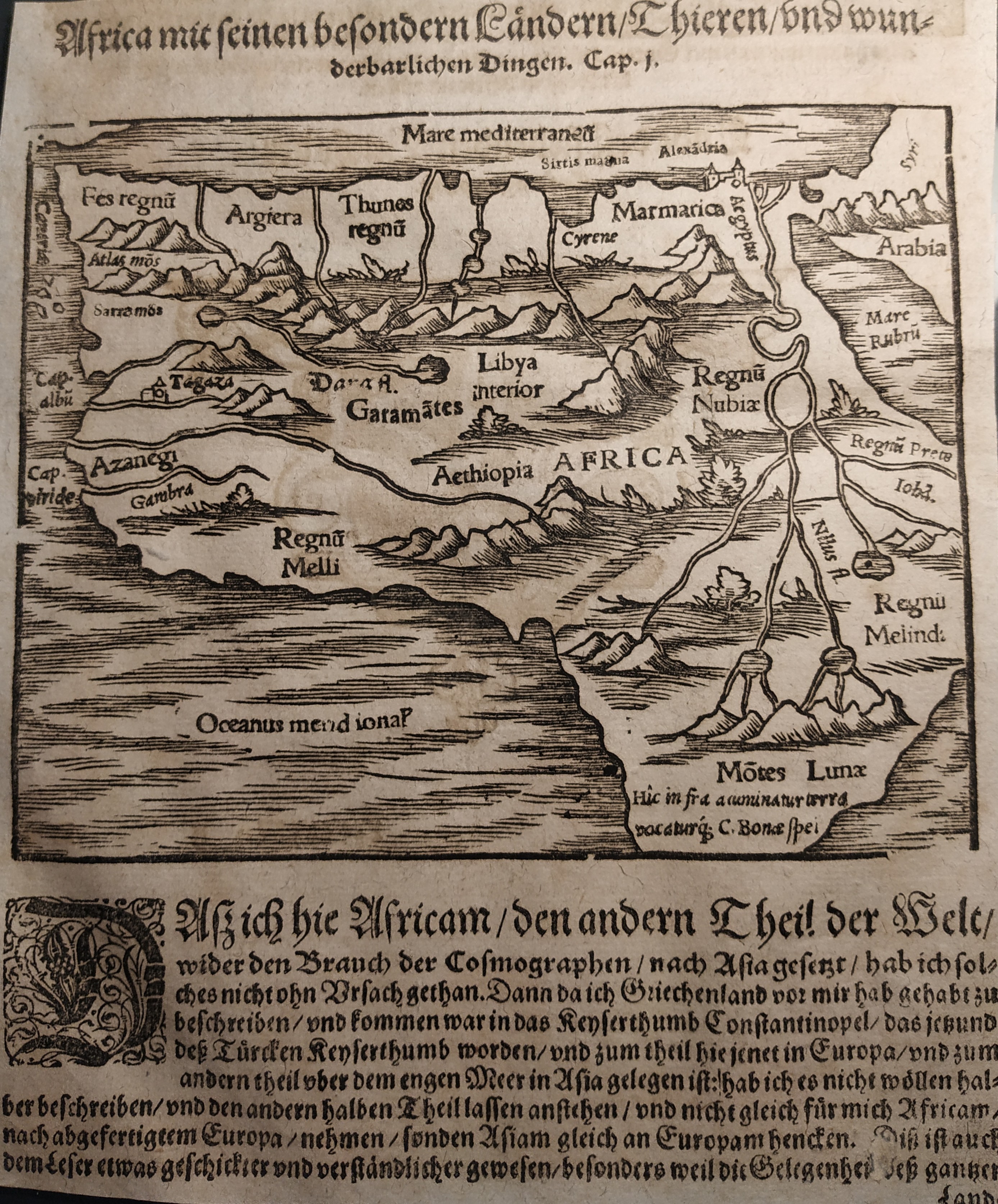
Africa
Author
Munster
Location shown in map
Africa
Edition date
Circa 1550
Edition place
Basel
Editor
Henrich Petri
Atlas
Cosmographia Universalis
Price
150 Euro
State
[mint/EXCELLENT/very good/good/fair/mediocre/poor]
Color
Black/white
Verso
German text
Size
Plate: cm (16 x 13) inches (6.3 x 5.12) Paper: cm (17 x 21) inches (6.69 x 8.27)
Technique
Woodcut
Note
No particular notes for this maps
Reference
Wiki
Here for more info
In stock
Available
Info
info@thetreasuremaps.com
Code
#0737
Africa
Author
Munster
Location shown in map
Africa
Edition date
Circa 1550
Edition place
Basel
Editor
Henrich Petri
Atlas
Cosmographia Universalis
Price
150 Euro
State
[mint/EXCELLENT/very good/good/fair/mediocre/poor]
Color
Black/white
Verso
German text
Size
Plate: cm (16 x 13) inches (6.3 x 5.12) Paper: cm (17 x 21) inches (6.69 x 8.27)
Technique
Woodcut
Note
No particular notes for this maps
Reference
Wiki
Here for more info
In stock
Available
Info
info@thetreasuremaps.com
Code
#0737
×
![]()
Map title
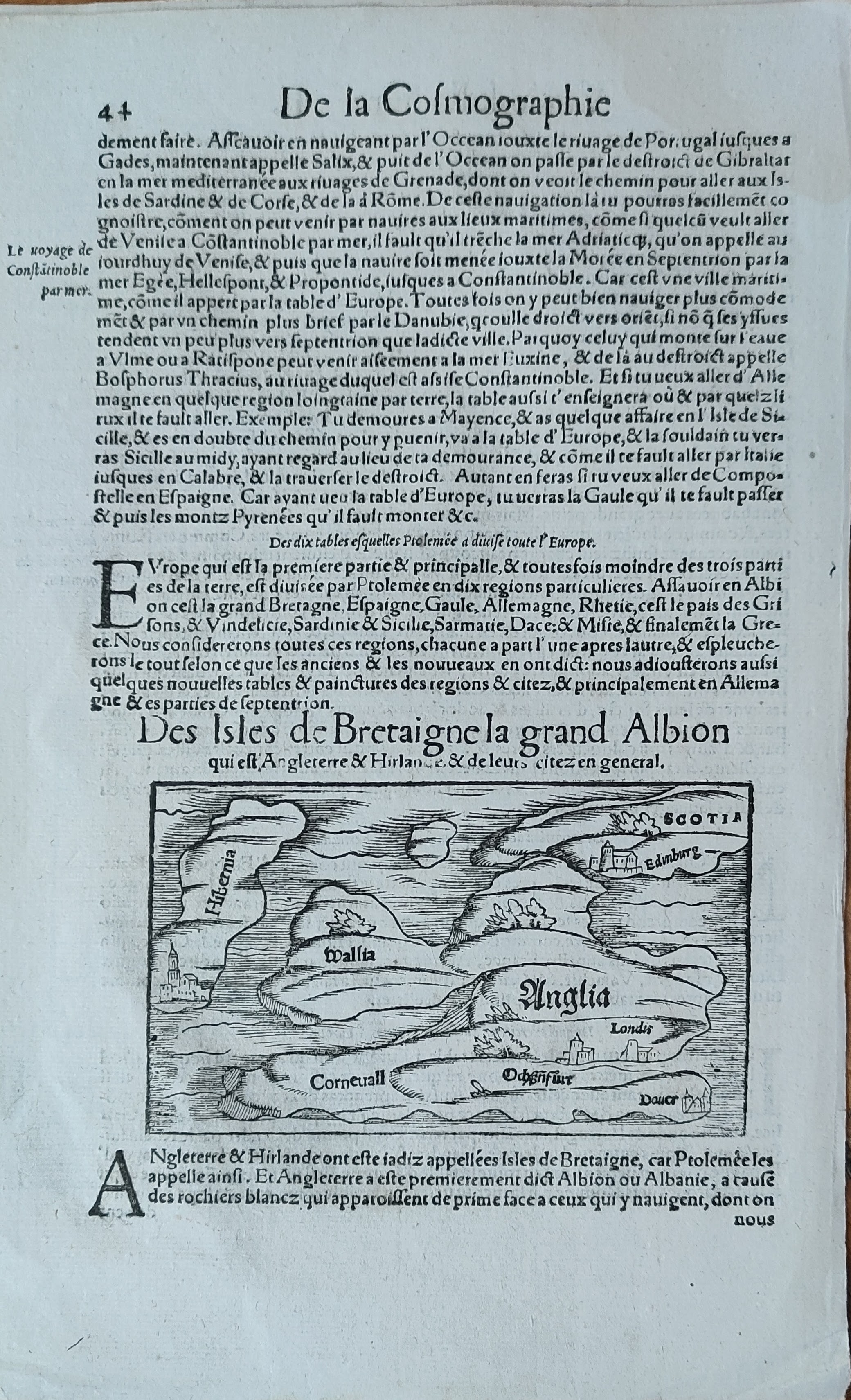
Des isles de Bretaigne la gran Albion
Author
Munster
Location shown in map
England
Edition date
Circa 1552
Edition place
Basel
Editor
Henrich Petri
Atlas
Cosmographia Universalis
Price
150 Euro
State
[mint/EXCELLENT/very good/good/fair/mediocre/poor]
Color
Black/white
Verso
French text pag.43
Size
Plate: cm (13 x 8) inches (5.12 x 3.15) Paper: cm (20 x 31) inches (7.87 x 12.2)
Technique
Woodcut
Note
Reference
Wiki
Here for more info
In stock
Available
Info
info@thetreasuremaps.com
Code
#0954
×
![]()
Map title
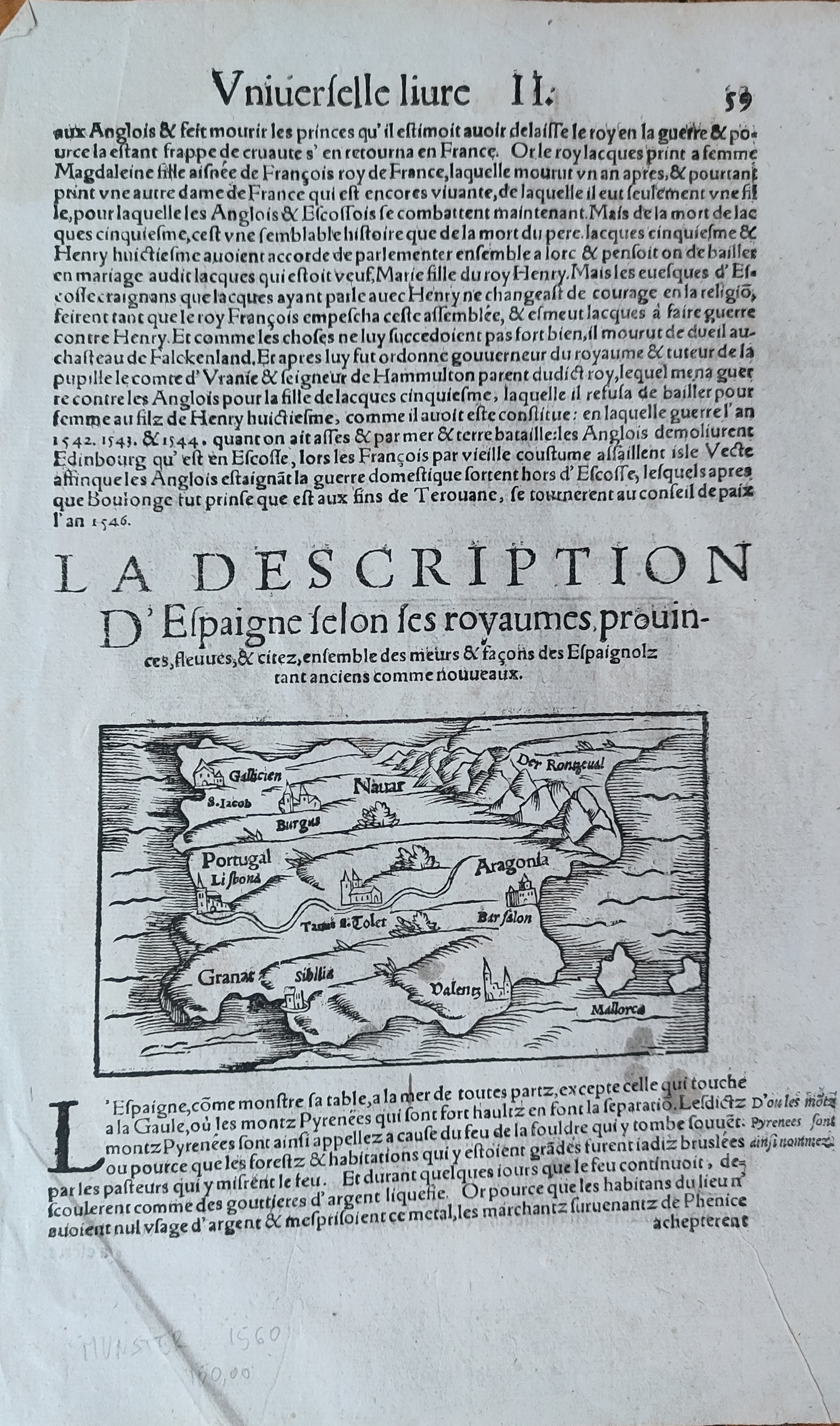
Espaigne
Author
Munster
Location shown in map
Spain
Edition date
Circa 1552
Edition place
Basel
Editor
Henrich Petri
Atlas
Cosmographia Universalis
Price
125 Euro
State
[mint/EXCELLENT/very good/good/fair/mediocre/poor]
Color
Black/white
Verso
French text pag.60
Size
Plate: cm (13 x 8) inches (5.12 x 3.15) Paper: cm (20 x 31) inches (7.87 x 12.2)
Technique
Woodcut
Note
Reference
Wiki
Here for more info
In stock
Available
Info
info@thetreasuremaps.com
Code
#0955
×
![]()
Map title
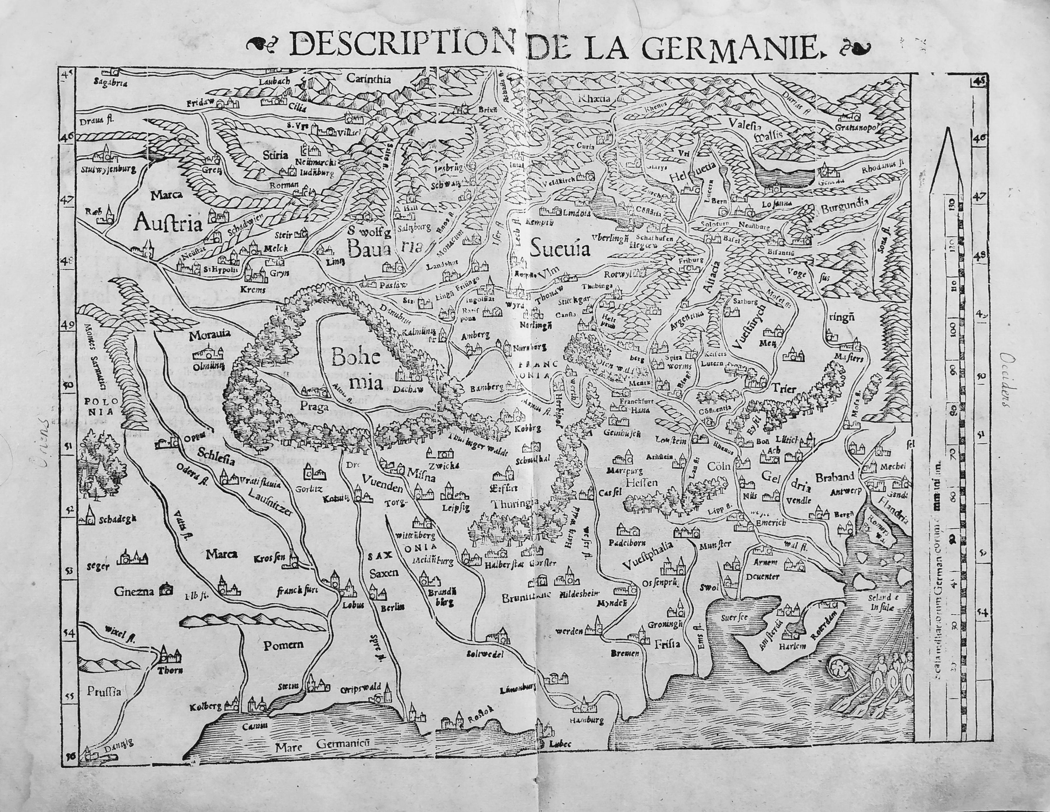
Description de la Germanie
Author
Munster
Location shown in map
Germany
Edition date
1552
Edition place
Basel
Editor
Henrich Petri
Atlas
Cosmographia Universalis
Price
300 Euro
State
[mint/EXCELLENT/very good/good/fair/mediocre/poor]
Color
Black/white
Verso
Franch text pag.6
Size
Plate: cm (34 x 25) inches (13.39 x 9.84) Paper: cm (39 x 30) inches (15.35 x 11.81)
Technique
Woodcut
Note
No particular notes for this maps.
Reference
--
Wiki
Here for more info
In stock
Available
Info
info@thetreasuremaps.com
Code
#0722
×
![]()
Map title
--
Author
Munster
Location shown in map
Italy
Edition date
Circa 1552
Edition place
Basel
Editor
Henrich Petri
Atlas
Cosmographia Universalis
Price
250 Euro
State
[mint/EXCELLENT/very good/good/fair/mediocre/poor]
Color
Black/white
Verso
French text pag.142
Size
Plate: cm (13 x 8) inches (5.12 x 3.15) Paper: cm (21 x 31) inches (8.27 x 12.2)
Technique
Woodcut
Note
Reference
R.Borri L'Italia nelle antiche carte pag.40
Wiki
Here for more info
In stock
Available
Info
info@thetreasuremaps.com
Code
#0630
×
![]()
Map title
--
Author
Munster
Location shown in map
Italy
Edition date
Circa 1552
Edition place
Basel
Editor
Henrich Petri
Atlas
Cosmographia Universalis
Price
250 Euro
State
[mint/EXCELLENT/very good/good/fair/mediocre/poor]
Color
Black/white
Verso
German text pag.105
Size
Plate: cm (13 x 16) inches (5.12 x 6.3) Paper: cm (21 x 31) inches (8.27 x 12.2)
Technique
Woodcut
Note
Reference
Wiki
Here for more info
In stock
Available
Info
info@thetreasuremaps.com
Code
#1101
×
![]()
Map title
Syria Cypern Palestina Mesopotamia Babylonia Chaldea und zwey Arabia mit Bergen Wassern und Statten
Author
Munster
Location shown in map
Holy Land
Edition date
1555
Edition place
Basel
Editor
Henrich Petri
Atlas
Cosmographia Universalis
Price
300 Euro
State
[mint/excellent/very good/GOOD/fair/mediocre/poor]
Color
Black/white
Verso
German text
Size
Plate: cm (34.3 x 25.4) inches (13.5 x 10) Paper: cm (40.6 x 31.8) inches (15.98 x 12.52)
Technique
Woodcut
Note
Middle East from the Nile Delta to the southern coast of Turkey. Tabulae Asiae IV.
Reference
--
Wiki
Here for more info
In stock
Available
Info
info@thetreasuremaps.com
Code
#0178
×
![]()
Map title
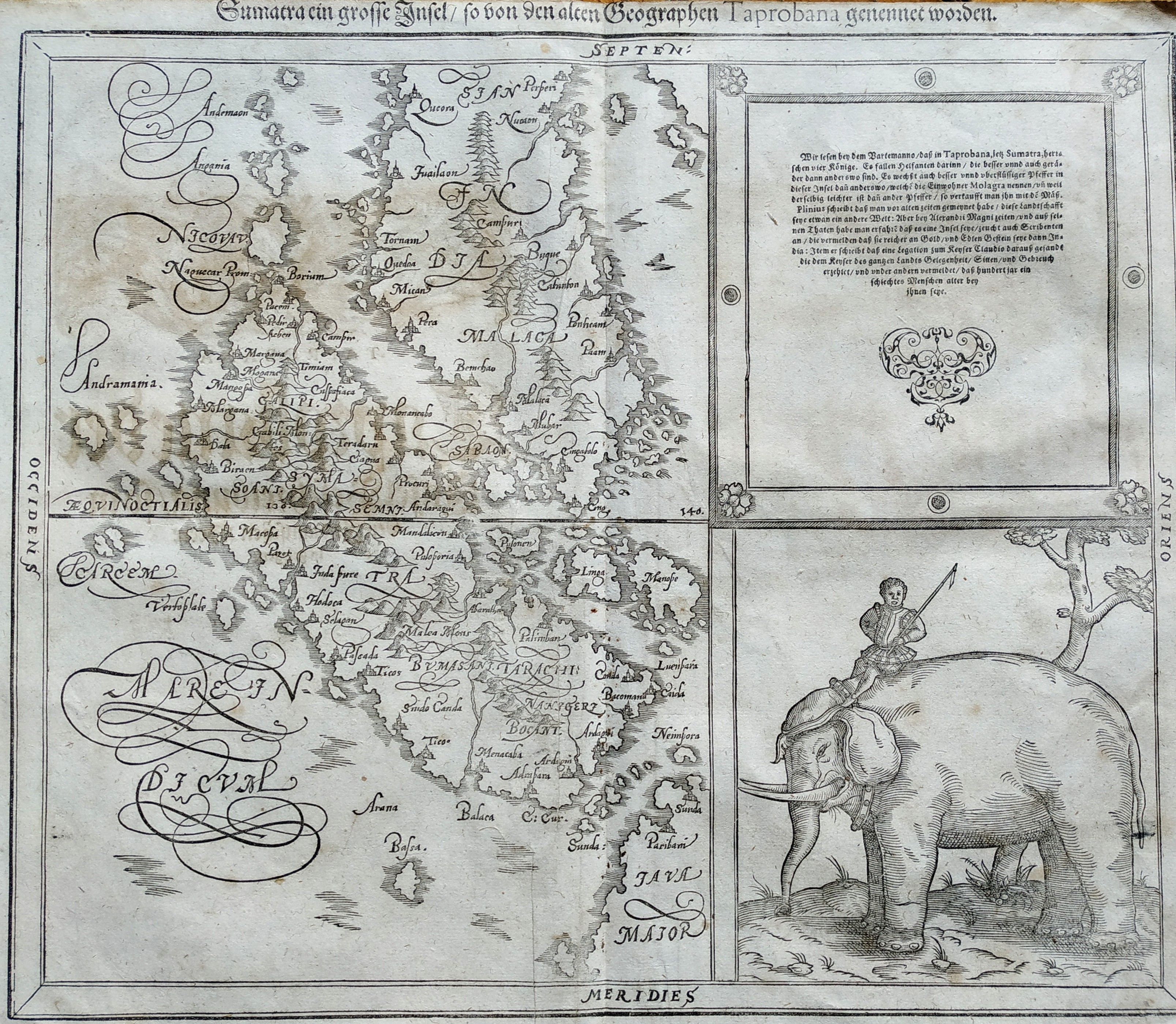
Sumatra ein grosse Inseln so von den alten Geographen Taprobana ist genent worden
Author
Munster
Location shown in map
Ceylon
Edition date
1555
Edition place
Basel
Editor
Henrich Petri
Atlas
Cosmographia Universalis
Price
500 Euro
State
[mint/EXCELLENT/very good/good/fair/mediocre/poor]
Color
Black/white
Verso
German text
Size
Plate: cm (33 x 24.1) inches (12.99 x 9.49) Paper: cm (30.5 x 40.6) inches (12.01 x 15.98)
Technique
Woodcut
Note
With large elephant vignette. Tabulae Asiae XII.
Reference
--
Wiki
Here for more info
In stock
Available
Info
info@thetreasuremaps.com
Code
#0177
×
![]()
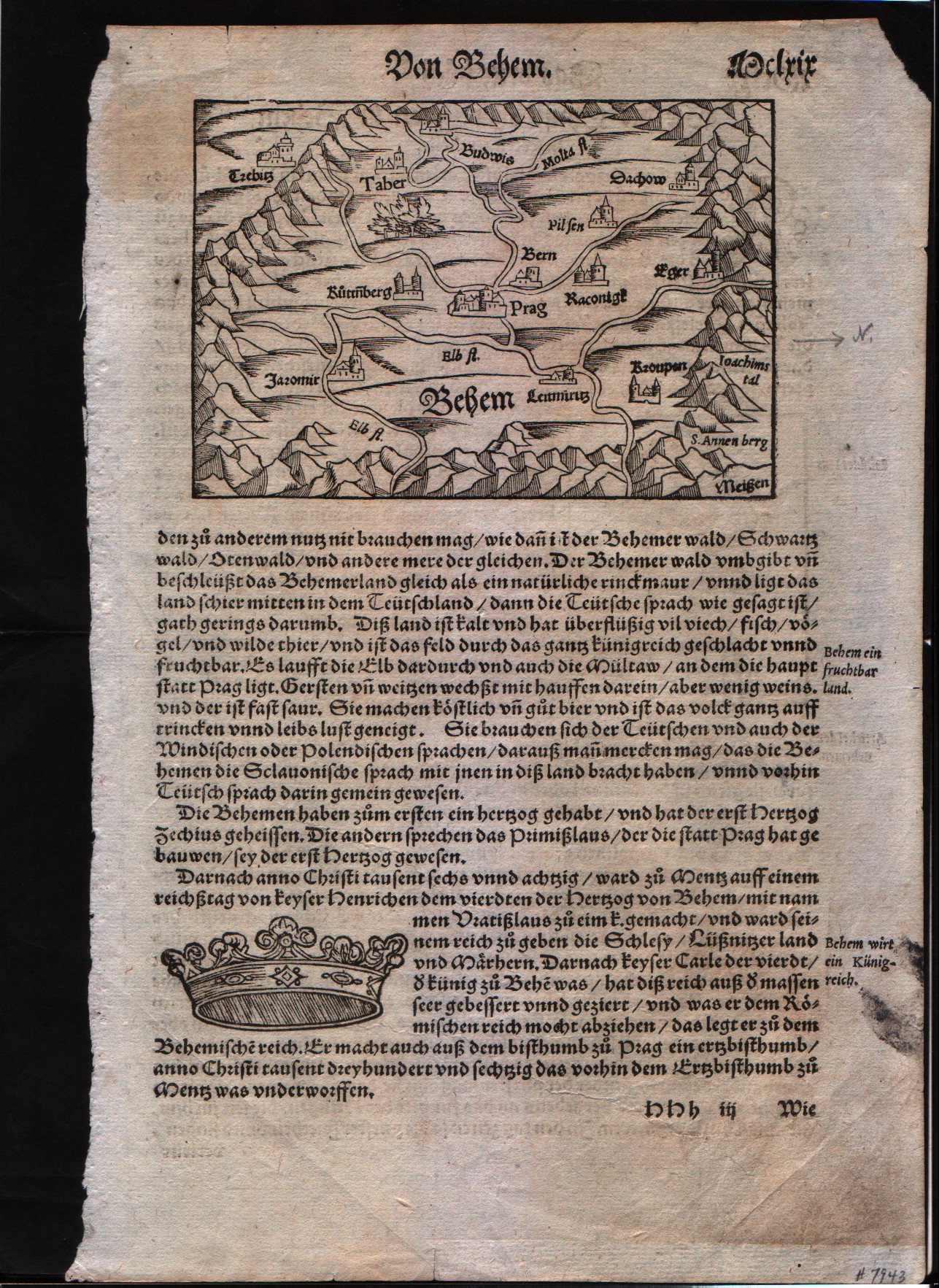
Map title
Prag area
Author
Munster
Location shown in map
Prag area
Edition date
1560
Edition place
???
Editor
Henrich Petri
Atlas
Cosmographia Universalis
Price
Please ask: info@thetreasuremaps.com
State
[mint/EXCELLENT/very good/good/fair/mediocre/poor]
Color
Black/white
Verso
German text
Size
Plate: cm (8.9 x 14) inches (3.5 x 5.51) Paper: cm (44.4 x 29.2) inches (17.48 x 11.5)
Technique
Woodcut
Note
No particular notes for this maps
Reference
--
Wiki
Here for more info
In stock
Available
Info
info@thetreasuremaps.com
Code
#0098
Prag area
Author
Munster
Location shown in map
Prag area
Edition date
1560
Edition place
???
Editor
Henrich Petri
Atlas
Cosmographia Universalis
Price
Please ask: info@thetreasuremaps.com
State
[mint/EXCELLENT/very good/good/fair/mediocre/poor]
Color
Black/white
Verso
German text
Size
Plate: cm (8.9 x 14) inches (3.5 x 5.51) Paper: cm (44.4 x 29.2) inches (17.48 x 11.5)
Technique
Woodcut
Note
No particular notes for this maps
Reference
--
Wiki
Here for more info
In stock
Available
Info
info@thetreasuremaps.com
Code
#0098
×
![]()
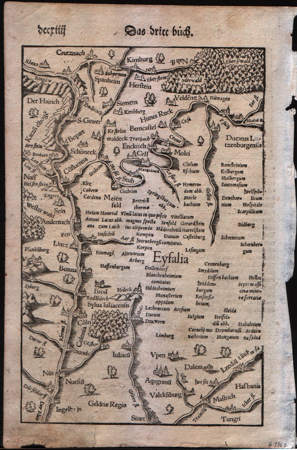
Map title
German Rhine
Author
Munster
Location shown in map
The Rhine Valley in Germany
Edition date
1560
Edition place
???
Editor
Henrich Petri
Atlas
Cosmographia Universalis
Price
Please ask: info@thetreasuremaps.com
State
[mint/EXCELLENT/very good/good/fair/mediocre/poor]
Color
Black/white
Verso
German text
Size
Plate: cm (16.5 x 25.4) inches (6.5 x 10) Paper: cm (19 x 29.2) inches (7.48 x 11.5)
Technique
Woodcut
Note
No particular notes for this maps
Reference
--
Wiki
Here for more info
In stock
Available
Info
info@thetreasuremaps.com
Code
#0097
×
![]()
Map title
Tavola dell'isole nuove, le quali son nominate occidentali, & indiane per diversi rispetti
Author
Munster
Location shown in map
North and south America.
Edition date
1571
Edition place
Vernice
Editor
Henrich Petri
Atlas
Cosmographia Universalis
Price
Please ask: info@thetreasuremaps.com
State
[mint/excellent/VERY GOOD/good/fair/mediocre/poor] need to be restored
Color
Black/white
Verso
Italian text
Size
Plate: cm (33.7 x 26) inches (13.27 x 10.24) Paper: cm (41.9 x 31.8) inches (16.5 x 12.52)
Technique
Woodcut
Note
Superb woodcut map of North/South America, has Magellan's ship in the Pacific along with large Zipangi (Japan). Cathay just makes page upper left. This is the first separate printed map of the Western Hemisphere.
Reference
--
Wiki
Here for more info
In stock
Sold
Info
info@thetreasuremaps.com
Code
#0401
×
![]()
Map title
Europe
Author
Munster
Location shown in map
Genoa
Edition date
1578
Edition place
Basel
Editor
Henrich Petri
Atlas
Cosmographia Universalis
Price
Please ask: info@thetreasuremaps.com
State
[mint/excellent/VERY GOOD/good/fair/mediocre/poor]
Color
Black/white
Verso
German text
Size
Plate: cm (40.6 x 14) inches (15.98 x 5.51) Paper: cm (41.9 x 33) inches (16.5 x 12.99)
Technique
Woodcut
Note
--
Reference
--
Wiki
Here for more info
In stock
Available
Info
info@thetreasuremaps.com
Code
#0590
×
![]()
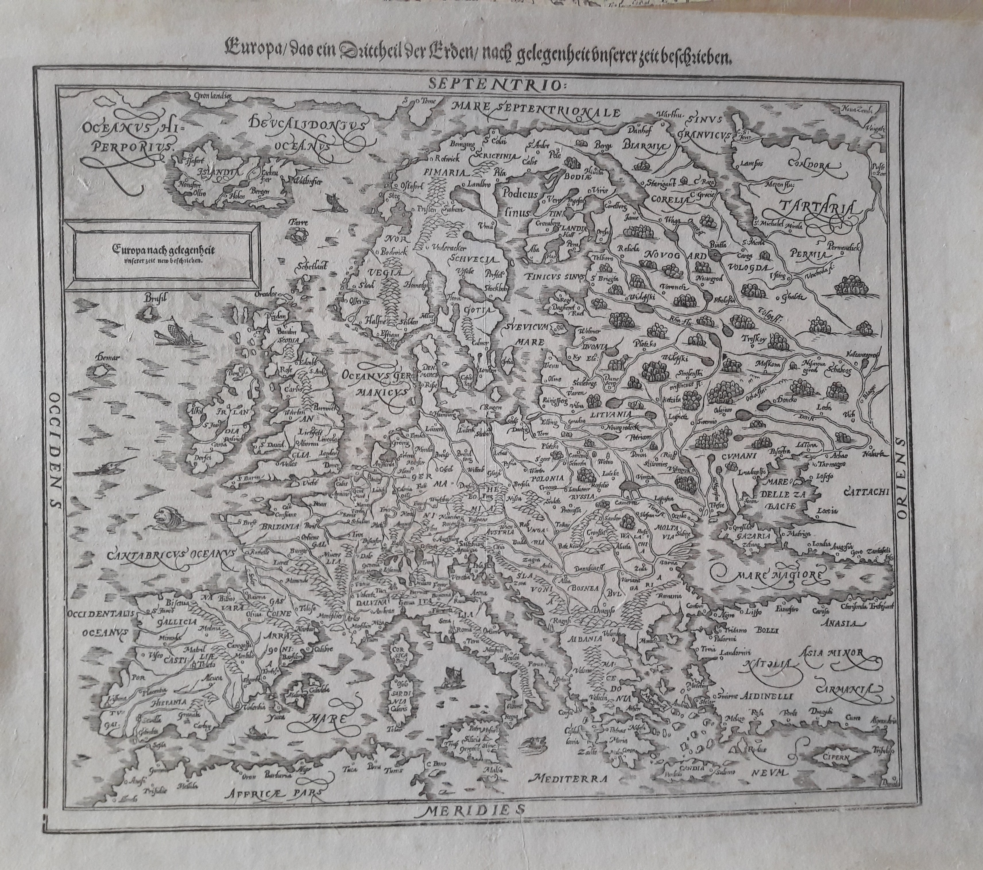
Map title
Europe
Author
Munster
Location shown in map
Europe
Edition date
1578
Edition place
Basel
Editor
Henrich Petri
Atlas
Cosmographia Universalis
Price
400 Euro
State
[mint/excellent/VERY GOOD/good/fair/mediocre/poor]
Color
Black/white
Verso
German text
Size
Plate: cm (35.6 x 30.5) inches (14.02 x 12.01) Paper: cm (43.2 x 36.8) inches (17.01 x 14.49)
Technique
Woodcut
Note
--
Reference
--
Wiki
Here for more info
In stock
Available
Info
info@thetreasuremaps.com
Code
#0214
Europe
Author
Munster
Location shown in map
Europe
Edition date
1578
Edition place
Basel
Editor
Henrich Petri
Atlas
Cosmographia Universalis
Price
400 Euro
State
[mint/excellent/VERY GOOD/good/fair/mediocre/poor]
Color
Black/white
Verso
German text
Size
Plate: cm (35.6 x 30.5) inches (14.02 x 12.01) Paper: cm (43.2 x 36.8) inches (17.01 x 14.49)
Technique
Woodcut
Note
--
Reference
--
Wiki
Here for more info
In stock
Available
Info
info@thetreasuremaps.com
Code
#0214
×
![]()
Map title
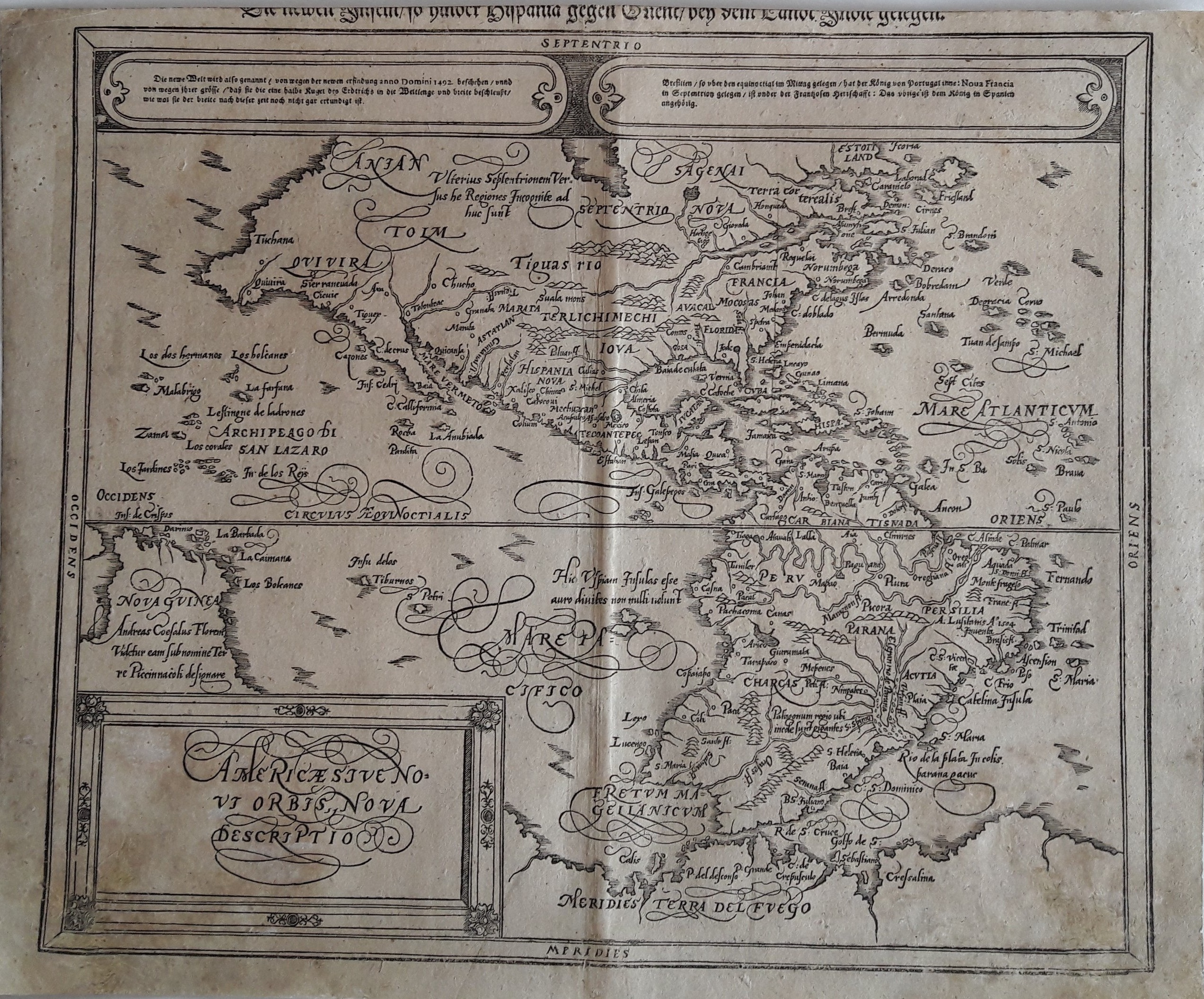
Americae sive novi Orbis, nova Descriptio
Author
Munster
Location shown in map
North and south America.
Edition date
1590
Edition place
--
Editor
Henrich Petri
Atlas
Cosmographia Universalis
Price
Please ask: info@thetreasuremaps.com
State
[mint/excellent/very good/good/FAIR/mediocre/poor] need to be restored
Color
Black/white
Verso
German text
Size
Plate: cm (34.3 x 30.5) inches (13.5 x 12.01) Paper: cm (39.4 x 33) inches (15.51 x 12.99)
Technique
Woodcut
Note
Influential wood cut map from Munsters Cosmographia, based on Ortelius 1570 map, with the bulge on the west coast of South America. This map replaced the highly speculative Munster map of 1540
Reference
--
Wiki
Here for more info
In stock
Available
Info
info@thetreasuremaps.com
Code
#0054
×
![]()
Map title
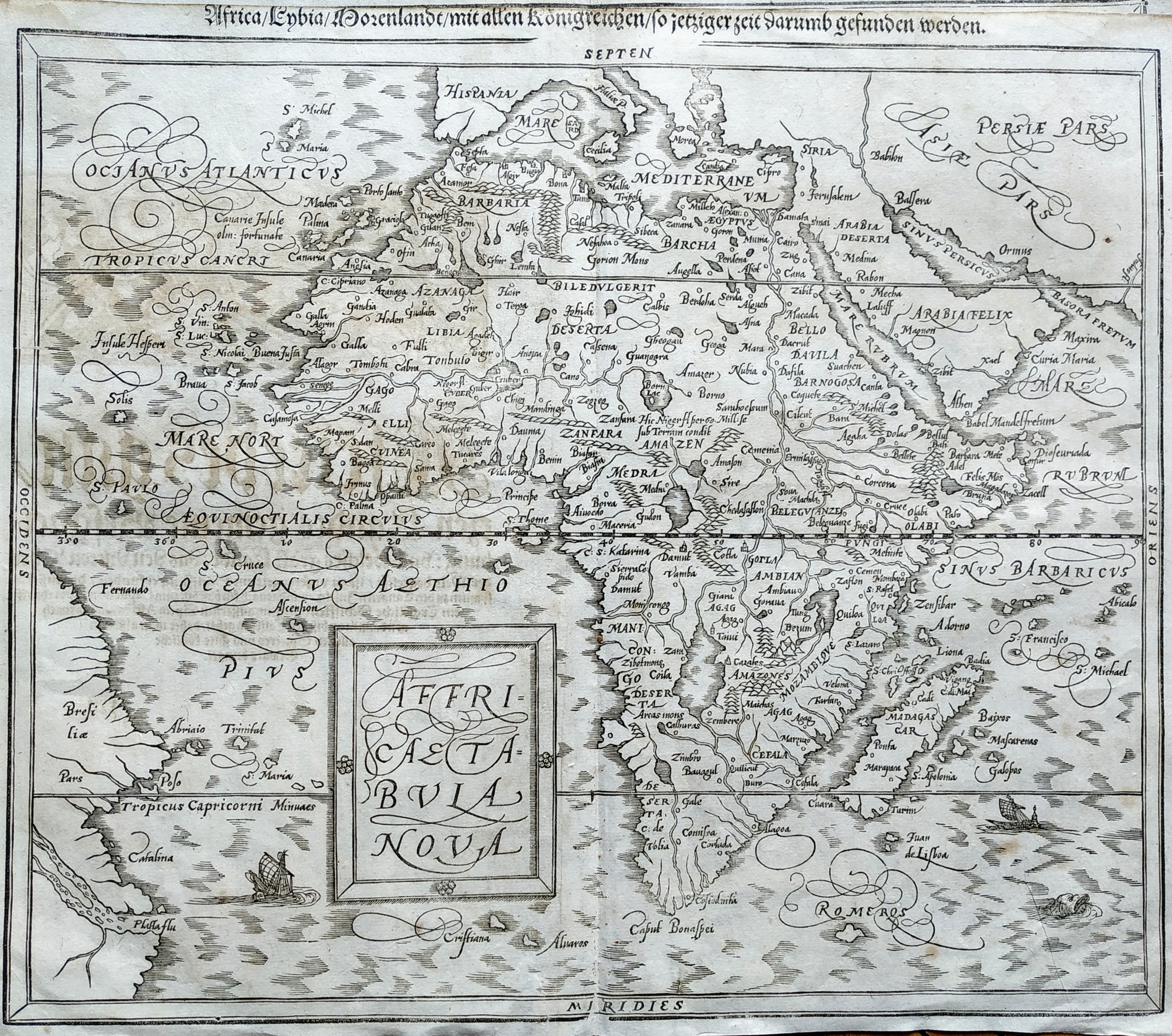
Africa Tabula Nova
Author
Munster
Location shown in map
Africa
Edition date
1598
Edition place
Basel
Editor
Henrich Petri
Atlas
Cosmographia Universalis
Price
400 Euro
State
[mint/excellent/VERY GOOD/good/fair/mediocre/poor]
Color
Black/white
Verso
German text
Size
Plate: cm (36 x 31) inches (14.17 x 12.2) Paper: cm (38 x 33) inches (14.96 x 12.99)
Technique
Woodcut
Note
No particular notes for this maps
Reference
--
Wiki
Here for more info
In stock
Available
Info
info@thetreasuremaps.com
Code
#0732
×
![]()
Map title
Sumatra
Author
Munster
Location shown in map
Sumatra
Edition date
1598
Edition place
Basel
Editor
Henrich Petri
Atlas
Cosmographia Universalis
Price
400 Euro
State
[mint/excellent/VERY GOOD/good/fair/mediocre/poor]
Color
Black/white
Verso
German text
Size
Plate: cm (57 x 47) inches (22.44 x 18.5) Paper: cm (66 x 55) inches (25.98 x 21.65)
Technique
Woodcut
Note
No particular notes for this maps
Reference
--
Wiki
Here for more info
In stock
Available
Info
info@thetreasuremaps.com
Code
#0733
Sumatra
Author
Munster
Location shown in map
Sumatra
Edition date
1598
Edition place
Basel
Editor
Henrich Petri
Atlas
Cosmographia Universalis
Price
400 Euro
State
[mint/excellent/VERY GOOD/good/fair/mediocre/poor]
Color
Black/white
Verso
German text
Size
Plate: cm (57 x 47) inches (22.44 x 18.5) Paper: cm (66 x 55) inches (25.98 x 21.65)
Technique
Woodcut
Note
No particular notes for this maps
Reference
--
Wiki
Here for more info
In stock
Available
Info
info@thetreasuremaps.com
Code
#0733
×
![]()
Map title
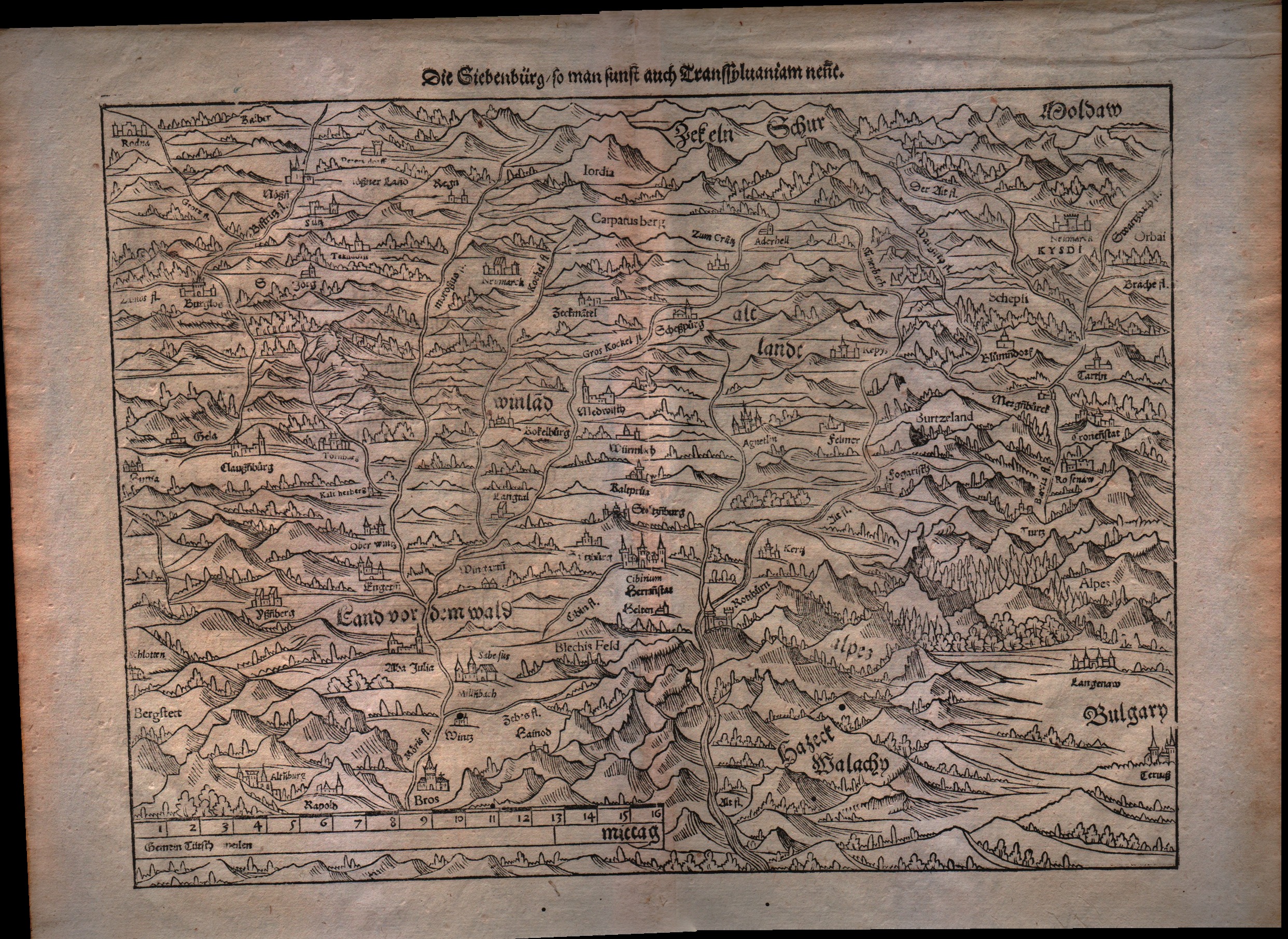
Die Siebenburg...
Author
Munster
Location shown in map
Transylvania and est Romania
Edition date
1598
Edition place
Basel
Editor
Henrich Petri
Atlas
Cosmographia Universalis
Price
150 Euro
State
[mint/EXCELLENT/very good/good/fair/mediocre/poor]
Color
Black/white
Verso
German text pag.???
Size
Plate: cm (34.3 x 25.4) inches (13.5 x 10) Paper: cm (40.6 x 33) inches (15.98 x 12.99)
Technique
Woodcut
Note
No particular notes for this maps
Reference
--
Wiki
Here for more info
In stock
Available
Info
info@thetreasuremaps.com
Code
#0115
×
![]()
Map title
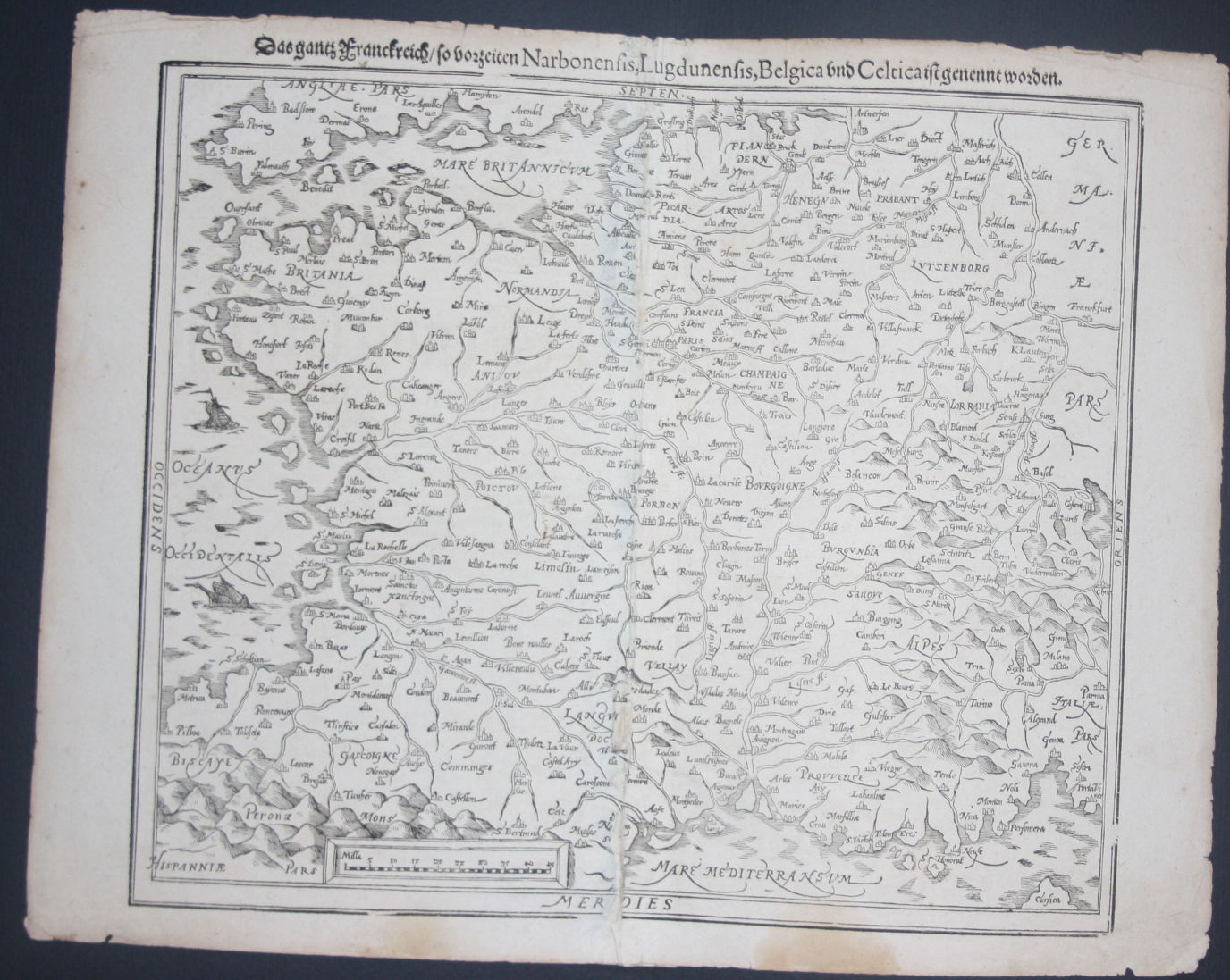
Narbonensis,Lugdunensis,Belgica and Celtica
Author
Munster
Location shown in map
France
Edition date
1598
Edition place
Basel
Editor
Henrich Petri
Atlas
Cosmographia Universalis
Price
150 Euro
State
[mint/excellent/very good/good/FAIR/mediocre/poor]
Color
Black/white
Verso
German text pag.???
Size
Plate: cm (35.6 x 30.5) inches (14.02 x 12.01) Paper: cm (43.2 x 33) inches (17.01 x 12.99)
Technique
Woodcut
Note
All France
Reference
--
Wiki
Here for more info
In stock
Available
Info
info@thetreasuremaps.com
Code
#0114
×
![]()
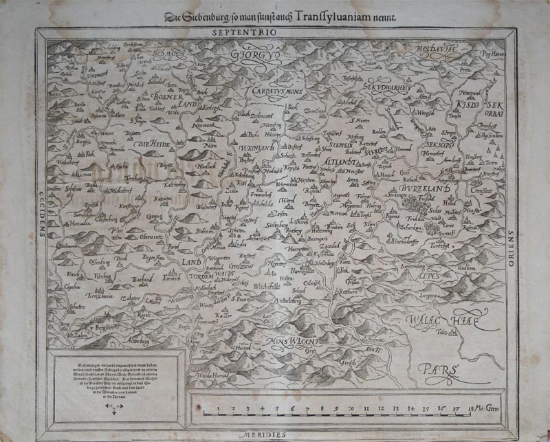
Map title
Die Siebenburg...
Author
Munster
Location shown in map
Transylvania and Bosnia
Edition date
1598
Edition place
Basel
Editor
Henrich Petri
Atlas
Cosmographia Universalis
Price
150 Euro
State
[mint/EXCELLENT/very good/good/fair/mediocre/poor]
Color
Black/white
Verso
German text pag.???
Size
Plate: cm (35.6 x 30.5) inches (14.02 x 12.01) Paper: cm (40.6 x 33) inches (15.98 x 12.99)
Technique
Woodcut
Note
Central Romania, Moldova at the top right and Wallachia at the bottom right.
Reference
--
Wiki
Here for more info
In stock
Available
Info
info@thetreasuremaps.com
Code
#0112
×
![]()
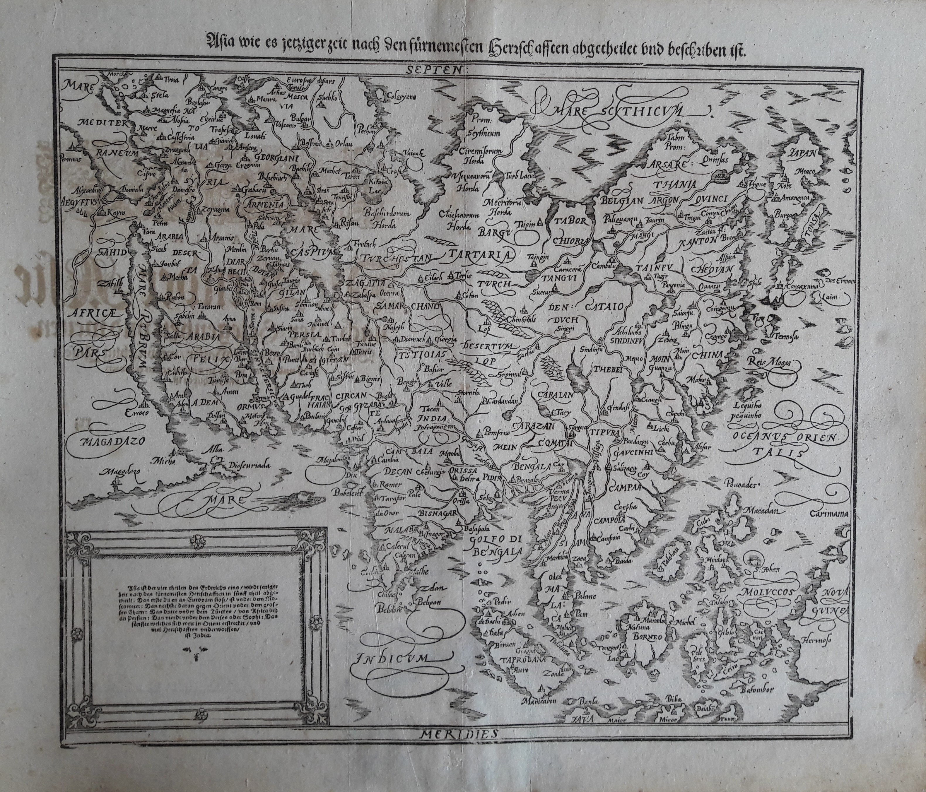
Map title
Asia
Author
Munster
Location shown in map
Asia
Edition date
1628
Edition place
Basel
Editor
Henrich Petri
Atlas
Cosmographia Universalis
Price
600 Euro
State
[mint/excellent/VERY GOOD/good/fair/mediocre/poor]
Color
Black/white
Verso
German text
Size
Plate: cm (35.6 x 30.5) inches (14.02 x 12.01) Paper: cm (43.2 x 36.8) inches (17.01 x 14.49)
Technique
Woodcut
Note
--
Reference
--
Wiki
Here for more info
In stock
Available
Info
info@thetreasuremaps.com
Code
#0213
Asia
Author
Munster
Location shown in map
Asia
Edition date
1628
Edition place
Basel
Editor
Henrich Petri
Atlas
Cosmographia Universalis
Price
600 Euro
State
[mint/excellent/VERY GOOD/good/fair/mediocre/poor]
Color
Black/white
Verso
German text
Size
Plate: cm (35.6 x 30.5) inches (14.02 x 12.01) Paper: cm (43.2 x 36.8) inches (17.01 x 14.49)
Technique
Woodcut
Note
--
Reference
--
Wiki
Here for more info
In stock
Available
Info
info@thetreasuremaps.com
Code
#0213
×
![]()