Sanson
Pages: 1 2
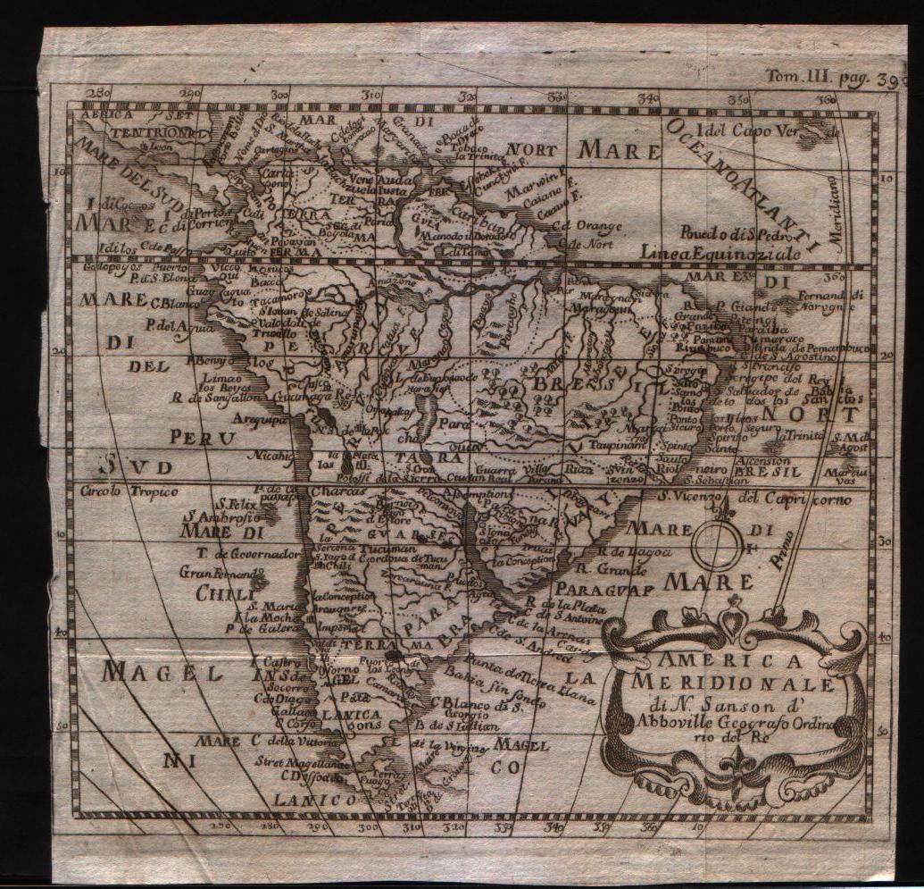
Map title
Carte generale des royaume d'Angleterre
Author
Sanson
Location shown in map
British Isles
Edition date
1640
Edition place
Paris
Editor
Melchior Tavenier
Atlas
Price
Please ask: info@thetreasuremaps.com
State
[mint/EXCELLENT/very good/good/fair/mediocre/poor]
Color
Old colors
Verso
Blank
Size
Plate: cm (52 x 39) inches (20.47 x 15.35) Paper: cm (57 x 44) inches (22.44 x 17.32)
Technique
Copper engraving
Note
No particular notes for this maps
Reference
Wiki
Here for more info
In stock
Available
Info
info@thetreasuremaps.com
Code
#0658
×
![Carte generale des royaume d'Angleterre by Sanson, British Isles, 1640]()
Map title
Les isles Antilles
Author
Sanson
Location shown in map
Antilles islands
Edition date
1656
Edition place
Paris
Editor
--
Atlas
Cartes generales de toutes les parties du monde -- Pierre Mariette
Price
600 Euro
State
[mint/EXCELLENT/very good/good/fair/mediocre/poor]
Color
Black/white
Verso
Blank
Size
Plate: cm (53.3 x 38.1) inches (20.98 x 15) Paper: cm (53.3 x 43.2) inches (20.98 x 17.01)
Technique
Copper engraving
Note
Professionally repaired
Reference
--
Wiki
Here for more info
In stock
Available
Info
info@thetreasuremaps.com
Code
#0343
×
![Les isles Antilles by Sanson, Antilles islands, 1656]()
Map title
Carte generale des royaume d'Angleterre
Author
Sanson
Location shown in map
British Isles
Edition date
1658
Edition place
Paris
Editor
Melchior Tavenier
Atlas
Price
350 Euro
State
[mint/excellent/VERY GOOD/good/fair/mediocre/poor]
Color
Old colors
Verso
Blank
Size
Plate: cm (52 x 39) inches (20.47 x 15.35) Paper: cm (57 x 44) inches (22.44 x 17.32)
Technique
Copper engraving
Note
Reference
Wiki
Here for more info
In stock
Available
Info
info@thetreasuremaps.com
Code
#1173
×
![Carte generale des royaume d'Angleterre by Sanson, British Isles, 1658]()
Map title
Partie de Lithuanie
Author
Sanson
Location shown in map
Lituania
Edition date
1665
Edition place
Paris
Editor
Atlas
Price
500 Euro
State
[mint/excellent/very good/good/FAIR/mediocre/poor]
Color
Old colors
Verso
Blank
Size
Plate: cm (56 x 41) inches (22.05 x 16.14) Paper: cm (60 x 46) inches (23.62 x 18.11)
Technique
Copper engraving
Note
Reference
Wiki
Here for more info
In stock
Available
Info
info@thetreasuremaps.com
Code
#1191
×
![Partie de Lithuanie by Sanson, Lituania, 1665]()
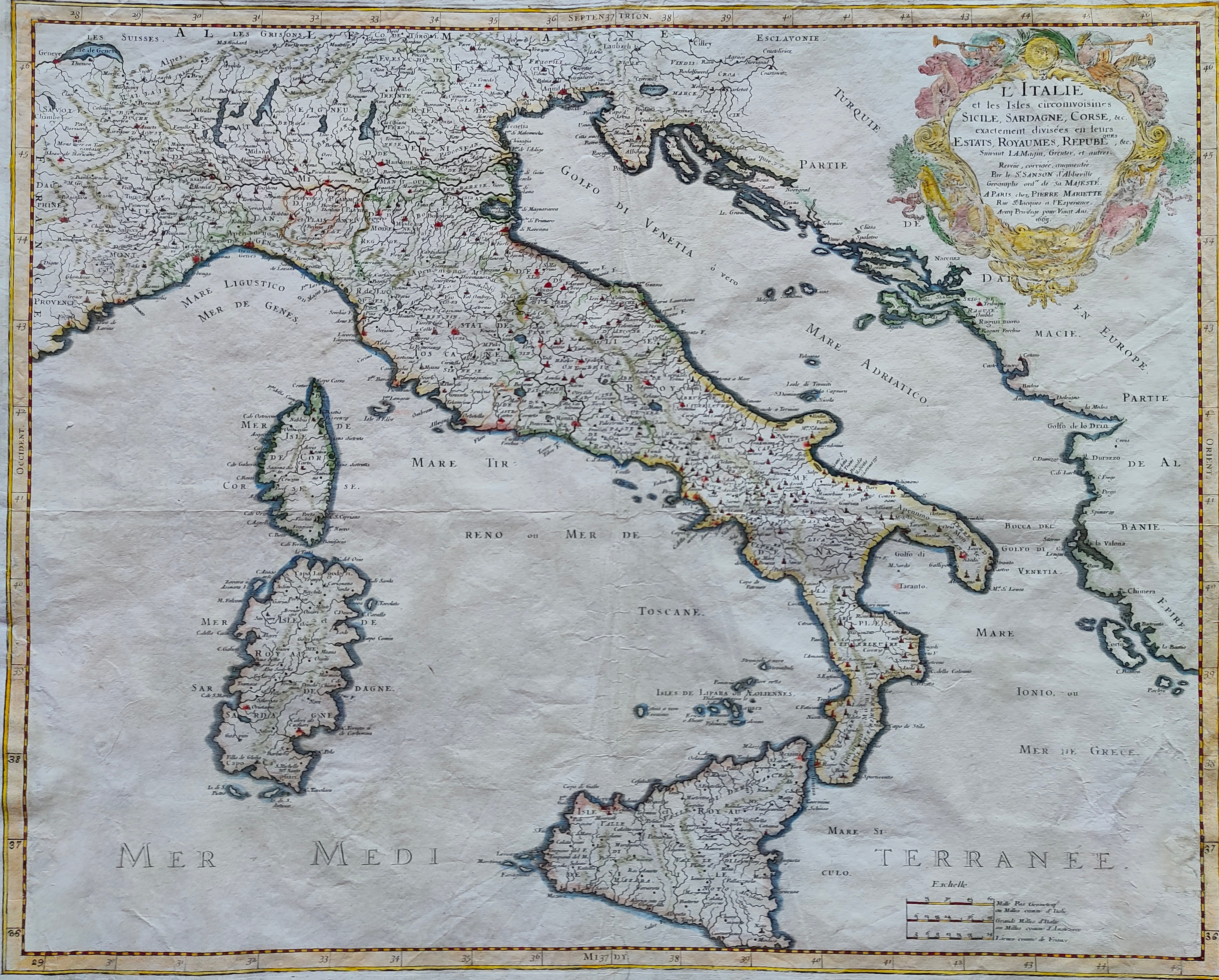
Map title
L'Italie
Author
Sanson
Location shown in map
Italy
Edition date
1665
Edition place
Paris
Editor
Atlas
Price
600 Euro
State
[mint/excellent/VERY GOOD/good/fair/mediocre/poor]
Color
Old colors
Verso
Blank
Size
Plate: cm (0 x 0) inches (0 x 0) Paper: cm (0 x 0) inches (0 x 0)
Technique
Copper engraving
Note
Reference
R.Borri L'Italia nelle antiche carte pag.144
Wiki
Here for more info
In stock
Available
Info
info@thetreasuremaps.com
Code
#0918
×
![L'Italie by Sanson, Italy, 1665]()
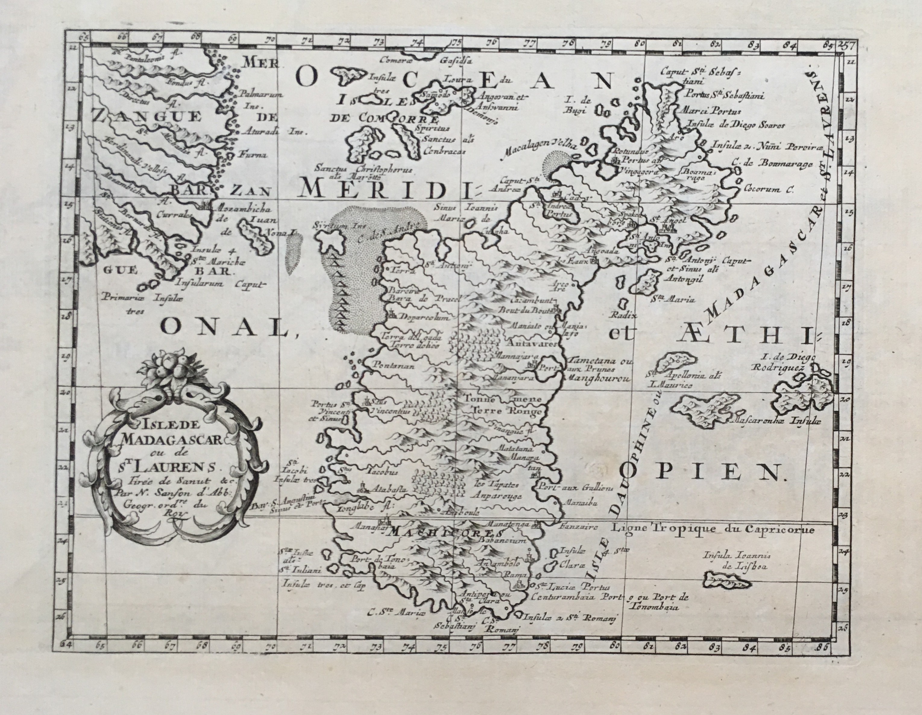
Map title
Isle de Madagascar
Author
Sanson
Location shown in map
Madagascar
Edition date
Circa 1667
Edition place
Paris
Editor
Atlas
Price
150 Euro
State
[mint/EXCELLENT/very good/good/fair/mediocre/poor]
Color
Black/white
Verso
Blank
Size
Plate: cm (25 x 19) inches (9.84 x 7.48) Paper: cm (41 x 27) inches (16.14 x 10.63)
Technique
Copper engraving
Note
Reference
Wiki
Here for more info
In stock
Available
Info
info@thetreasuremaps.com
Code
#0662
×
![Isle de Madagascar by Sanson, Madagascar, Circa 1667]()
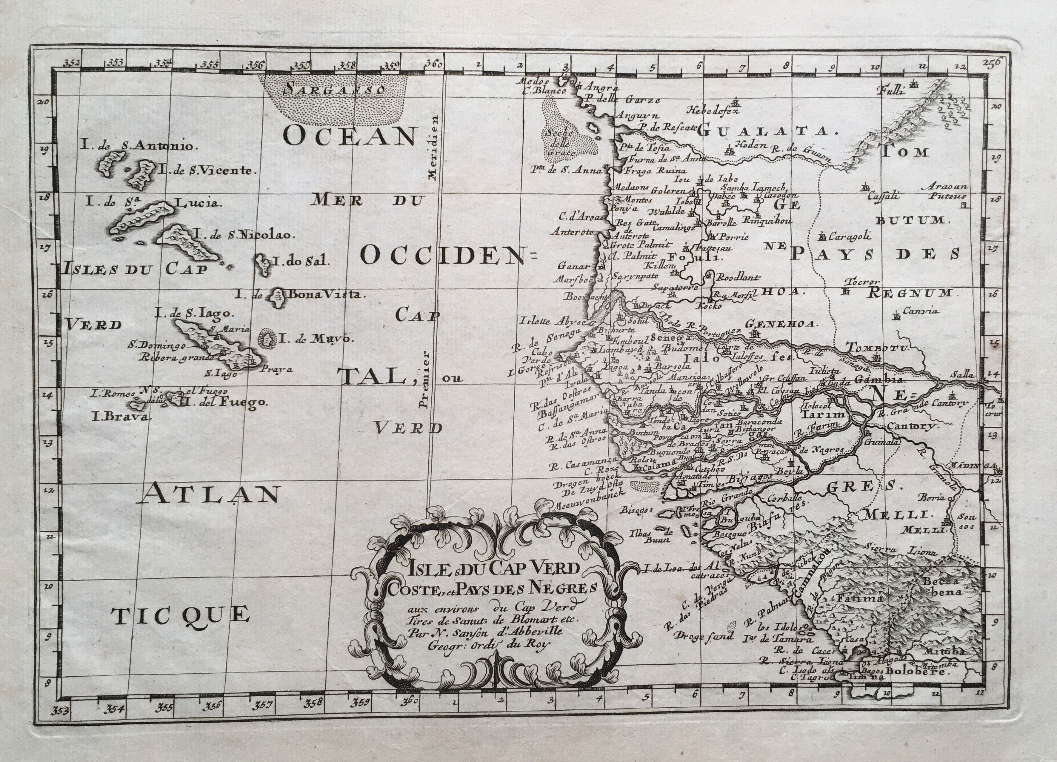
Map title
Isles du CapVerd
Author
Sanson
Location shown in map
West Africa
Edition date
Circa 1667
Edition place
Paris
Editor
Atlas
Price
175 Euro
State
[mint/EXCELLENT/very good/good/fair/mediocre/poor]
Color
Black/white
Verso
Blank
Size
Plate: cm (29 x 19) inches (11.42 x 7.48) Paper: cm (41 x 27) inches (16.14 x 10.63)
Technique
Copper engraving
Note
Reference
Wiki
Here for more info
In stock
Available
Info
info@thetreasuremaps.com
Code
#0663
×
![Isles du CapVerd by Sanson, West Africa, Circa 1667]()
Map title
Provincie meridionali de Paesi Bassi intese sotto nome di Fiandra overo i Paesi Bassi cattolici
Author
Sanson
Location shown in map
Nederland
Edition date
1672
Edition place
Rome
Editor
--
Atlas
??? printed by Giacomo Rossi.
Price
200 Euro
State
[mint/excellent/VERY GOOD/good/fair/mediocre/poor]
Color
Black/white
Verso
Blank
Size
Plate: cm (50.8 x 36.8) inches (20 x 14.49) Paper: cm (59.7 x 41.9) inches (23.5 x 16.5)
Technique
Copper engraving
Note
Map based on Sanson map.
Reference
--
Wiki
Here for more info
In stock
Available
Info
info@thetreasuremaps.com
Code
#0139
×
![Provincie meridionali de Paesi Bassi intese sotto nome di Fiandra overo i Paesi Bassi cattolici by Sanson, Nederland, 1672]()
Map title
Italia
Author
Sanson
Location shown in map
Italy
Edition date
1672
Edition place
Rome
Editor
De Rossi
Atlas
Price
400 Euro
State
[mint/EXCELLENT/very good/good/fair/mediocre/poor]
Color
Old colors
Verso
Blank
Size
Plate: cm (52 x 43) inches (20.47 x 16.93) Paper: cm (60 x 48) inches (23.62 x 18.9)
Technique
Copper engraving
Note
Reference
R.Borri L'Italia nelle antiche carte pag.149
Wiki
Here for more info
In stock
Available
Info
info@thetreasuremaps.com
Code
#1060
×
![Italia by Sanson, Italy, 1672]()
Map title
L'Italie
Author
Sanson
Location shown in map
Italy
Edition date
1672
Edition place
Paris
Editor
Alexis Hubert Jaillot
Atlas
Wall map
Price
Please ask: info@thetreasuremaps.com
State
[mint/EXCELLENT/very good/good/fair/mediocre/poor]
Color
Old colors
Verso
Blank
Size
Plate: cm (78 x 59) inches (30.71 x 23.23) Paper: cm (79 x 61) inches (31.1 x 24.02)
Technique
Copper engraving
Note
Reference
R.Borri L'Italia nelle antiche carte pag.159
Wiki
Here for more info
In stock
Available
Info
info@thetreasuremaps.com
Code
#0994
×
![L'Italie by Sanson, Italy, 1672]()

Map title
America Settentrional
Author
Sanson
Location shown in map
North America
Edition date
1680
Edition place
--
Editor
--
Atlas
--
Price
Please ask: info@thetreasuremaps.com
State
[mint/excellent/VERY GOOD/good/fair/mediocre/poor]
Color
Black/white
Verso
Blank
Size
Plate: cm (16.5 x 14) inches (6.5 x 5.51) Paper: cm (20.3 x 20.3) inches (7.99 x 7.99)
Technique
Copper engraving
Note
California as an island
Reference
--
Wiki
Here for more info
In stock
Sold
Info
info@thetreasuremaps.com
Code
#0406
×
![America Settentrional by Sanson, North America, 1680]()
Map title
Terre ferme, Nouveau Royme de Grenade
Author
Sanson
Location shown in map
Colombia
Edition date
Circa 1683
Edition place
Paris
Editor
Atlas
L'Europe en Plusieurs Cartes, et en divers Traittes de Geographie et d'Histoire.
Price
200 Euro
State
[mint/EXCELLENT/very good/good/fair/mediocre/poor]
Color
Old colors
Verso
Blank
Size
Plate: cm (29 x 19) inches (11.42 x 7.48) Paper: cm (32 x 22) inches (12.6 x 8.66)
Technique
Copper engraving
Note
Reference
Wiki
Here for more info
In stock
Available
Info
info@thetreasuremaps.com
Code
#1008
×
![Terre ferme, Nouveau Royme de Grenade by Sanson, Colombia, Circa 1683]()
Map title
Ceylan et les Maldives
Author
Sanson
Location shown in map
Ceylon
Edition date
Circa 1683
Edition place
Paris
Editor
Atlas
L'Europe en Plusieurs Cartes, et en divers Traittes de Geographie et d'Histoire.
Price
200 Euro
State
[mint/EXCELLENT/very good/good/fair/mediocre/poor]
Color
Old colors
Verso
Blank
Size
Plate: cm (24 x 19) inches (9.45 x 7.48) Paper: cm (32 x 22) inches (12.6 x 8.66)
Technique
Copper engraving
Note
Reference
Wiki
Here for more info
In stock
Available
Info
info@thetreasuremaps.com
Code
#1007
×
![Ceylan et les Maldives by Sanson, Ceylon, Circa 1683]()
Map title
Le Canada ou Novelle France
Author
Sanson
Location shown in map
North America
Edition date
Circa 1683
Edition place
Paris
Editor
Atlas
L'Europe en Plusieurs Cartes, et en divers Traittes de Geographie et d'Histoire.
Price
400 Euro
State
[mint/EXCELLENT/very good/good/fair/mediocre/poor]
Color
Old colors
Verso
Blank
Size
Plate: cm (30 x 21) inches (11.81 x 8.27) Paper: cm (32 x 22) inches (12.6 x 8.66)
Technique
Copper engraving
Note
Reference
Wiki
Here for more info
In stock
Available
Info
info@thetreasuremaps.com
Code
#0997
×
![Le Canada ou Novelle France by Sanson, North America, Circa 1683]()
Map title
Partie de duche de Milan, la principaute de Piemont le Montferrat et la Republique de Gens
Author
Sanson
Location shown in map
Liguria
Edition date
1692
Edition place
Paris
Editor
Alexis Hubert Jaillot
Atlas
Tables geographiques des divisions du globe terrestre
Price
600 Euro
State
[mint/EXCELLENT/very good/good/fair/mediocre/poor]
Color
Old colors
Verso
Blank
Size
Plate: cm (73 x 54) inches (28.74 x 21.26) Paper: cm (89 x 57) inches (35.04 x 22.44)
Technique
Copper engraving
Note
Reference
Wiki
Here for more info
In stock
Available
Info
info@thetreasuremaps.com
Code
#1234
×
![Partie de duche de Milan, la principaute de Piemont le Montferrat et la Republique de Gens by Sanson, Liguria, 1692]()
Map title
Asia vetus
Author
Sanson
Location shown in map
Asia
Edition date
1694
Edition place
Padua
Editor
Atlas
Price
350 Euro
State
[mint/excellent/very good/good/FAIR/mediocre/poor]
Color
Old colors
Verso
Size
Plate: cm (56 x 41) inches (22.05 x 16.14) Paper: cm (62 x 52) inches (24.41 x 20.47)
Technique
Copper engraving
Note
Reference
Wiki
Here for more info
In stock
Available
Info
info@thetreasuremaps.com
Code
#1194
×
![Asia vetus by Sanson, Asia, 1694]()
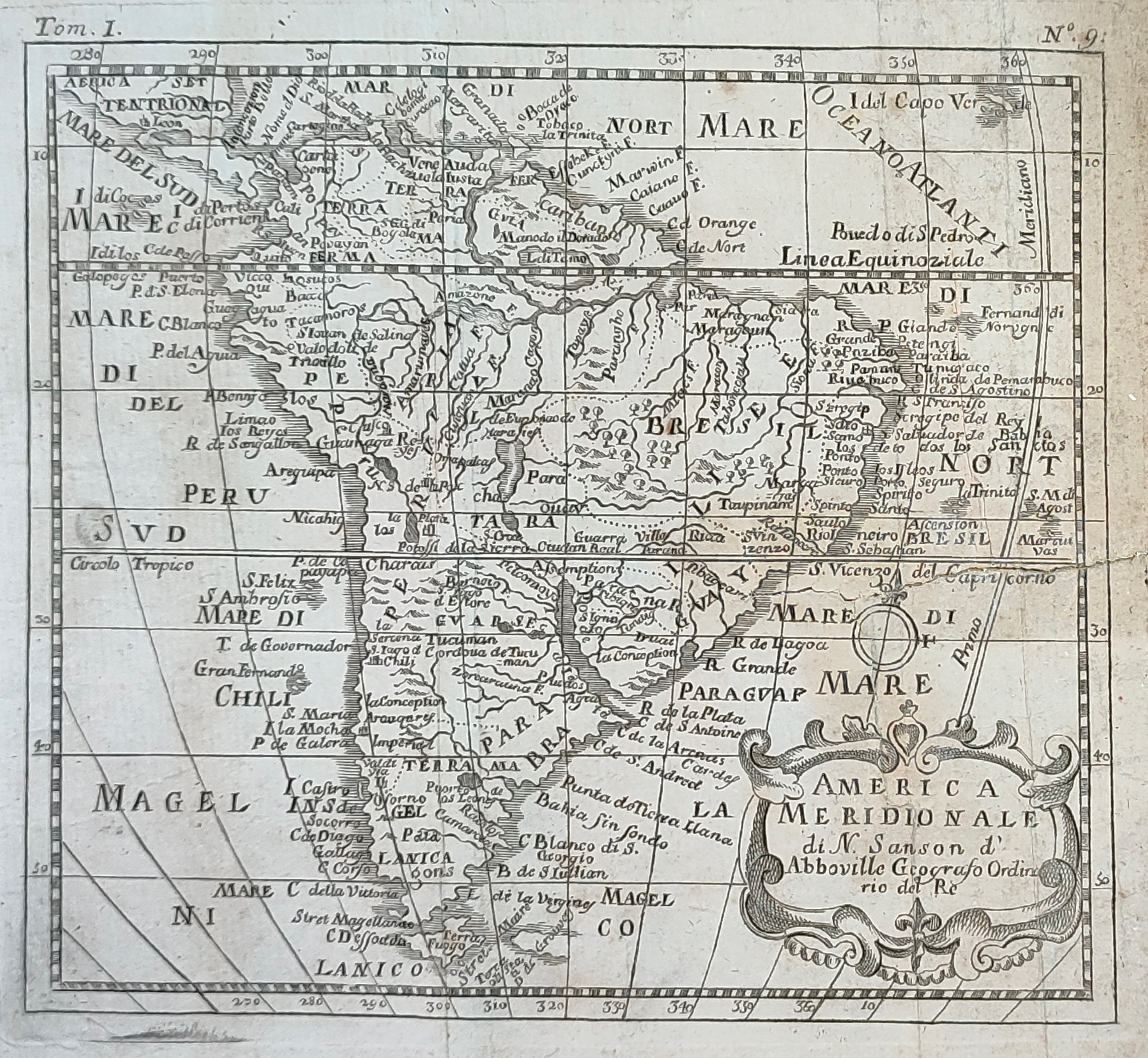
Map title
Amerique Meridionale
Author
Sanson
Location shown in map
South America
Edition date
1694
Edition place
Paris
Editor
Alexis Hubert Jaillot
Atlas
Tables geographiques des divisions du globe terrestre
Price
500 Euro
State
[mint/excellent/very good/GOOD/fair/mediocre/poor] Some repaire tears
Color
Black/white
Verso
Blank
Size
Plate: cm (86.4 x 55.9) inches (34.02 x 22.01) Paper: cm (91.4 x 66) inches (35.98 x 25.98)
Technique
Copper engraving
Note
Wall map
Reference
--
Wiki
Here for more info
In stock
Available
Info
info@thetreasuremaps.com
Code
#0019
×
![Amerique Meridionale by Sanson, South America, 1694]()
Map title
Africa
Author
Sanson
Location shown in map
Africa
Edition date
Circa 1720
Edition place
Editor
Atlas
Price
125 Euro
State
[mint/EXCELLENT/very good/good/fair/mediocre/poor]
Color
Black/white
Verso
Blank
Size
Plate: cm (16.5 x 15) inches (6.5 x 5.91) Paper: cm (21 x 19) inches (8.27 x 7.48)
Technique
Copper engraving
Note
Reference
--
Wiki
Here for more info
In stock
Available
Info
info@thetreasuremaps.com
Code
#1141
Africa
Author
Sanson
Location shown in map
Africa
Edition date
Circa 1720
Edition place
Editor
Atlas
Price
125 Euro
State
[mint/EXCELLENT/very good/good/fair/mediocre/poor]
Color
Black/white
Verso
Blank
Size
Plate: cm (16.5 x 15) inches (6.5 x 5.91) Paper: cm (21 x 19) inches (8.27 x 7.48)
Technique
Copper engraving
Note
Reference
--
Wiki
Here for more info
In stock
Available
Info
info@thetreasuremaps.com
Code
#1141
×
![Africa by Sanson, Africa, Circa 1720]()
Map title
America Meridionale
Author
Sanson
Location shown in map
South America
Edition date
1720
Edition place
--
Editor
--
Atlas
--
Price
100 Euro
State
[mint/excellent/VERY GOOD/good/fair/mediocre/poor]
Color
Black/white
Verso
Blank
Size
Plate: cm (15.2 x 15.2) inches (5.98 x 5.98) Paper: cm (16.5 x 16.5) inches (6.5 x 6.5)
Technique
Copper engraving
Note
No particular notes for this maps
Reference
--
Wiki
Here for more info
In stock
Available
Info
info@thetreasuremaps.com
Code
#0018
×
![America Meridionale by Sanson, South America, 1720]()
Map title
America Meridionale
Author
Sanson
Location shown in map
South America
Edition date
Circa 1720
Edition place
Editor
Atlas
Price
100 Euro
State
[mint/excellent/VERY GOOD/good/fair/mediocre/poor]
Color
Black/white
Verso
Blank
Size
Plate: cm (16.5 x 15) inches (6.5 x 5.91) Paper: cm (25 x 19) inches (9.84 x 7.48)
Technique
Copper engraving
Note
Reference
--
Wiki
Here for more info
In stock
Available
Info
info@thetreasuremaps.com
Code
#1142
×
![America Meridionale by Sanson, South America, Circa 1720]()
Pages: 1 2