1600-1699
Map title
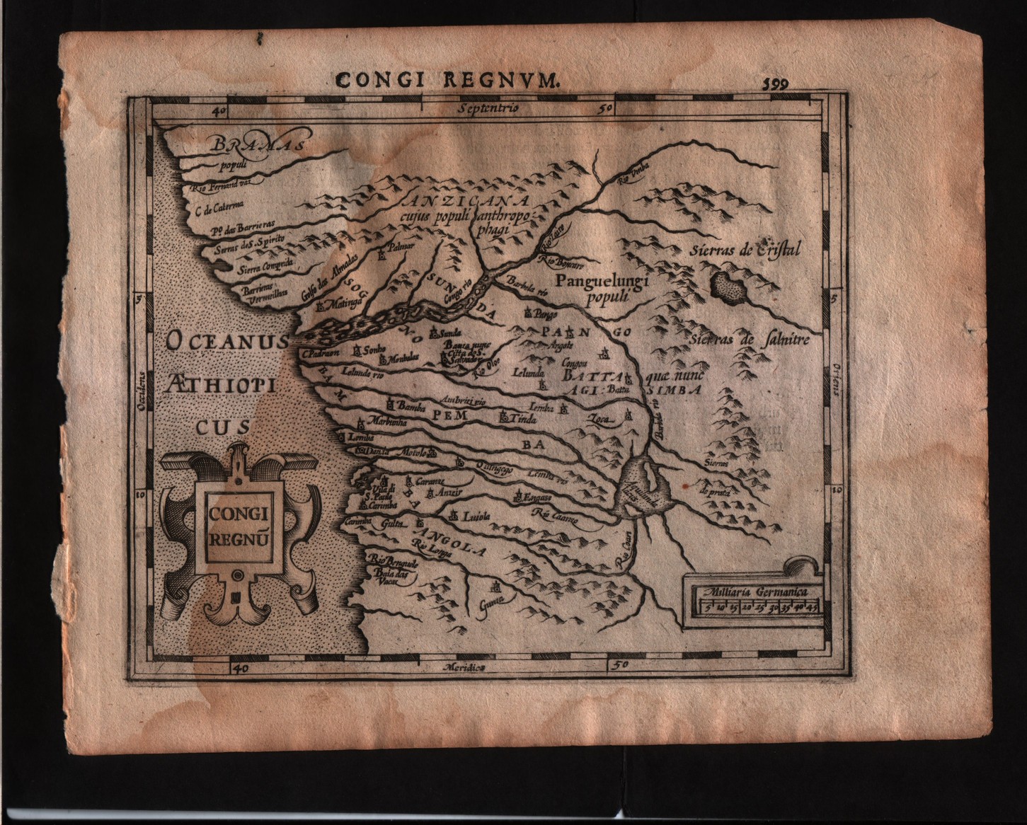
Congi regnum
Author
Mercator
Location shown in map
Congo
Edition date
1607
Edition place
Amsterdam
Editor
Janssonius
Atlas
Altas Minor Gerardi Mercatoris
Price
150 Euro
State
[mint/EXCELLENT/very good/good/fair/mediocre/poor]
Color
Black/white
Verso
Latin text pag.600
Size
Plate: cm (17.8 x 14) inches (7.01 x 5.51) Paper: cm (22.9 x 17.8) inches (9.02 x 7.01)
Technique
Copper engraving
Note
No particular notes for this maps
Reference
--
Wiki
Here for more info
In stock
Available
Info
info@thetreasuremaps.com
Code
#0292
×
![Congi regnum by Mercator, Congo, 1607]()
Map title
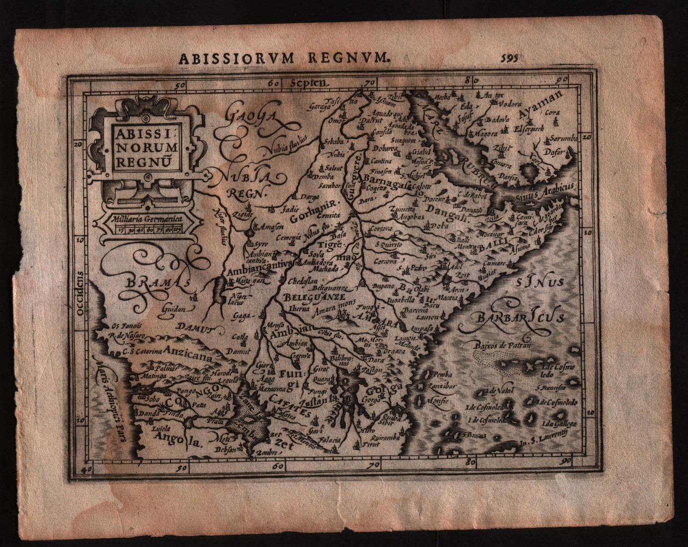
Abissinorum regnum
Author
Mercator
Location shown in map
East Africa
Edition date
1607
Edition place
Amsterdam
Editor
Janssonius
Atlas
Altas Minor Gerardi Mercatoris
Price
150 Euro
State
[mint/EXCELLENT/very good/good/fair/mediocre/poor]
Color
Black/white
Verso
Latin text pag.596
Size
Plate: cm (17.8 x 14) inches (7.01 x 5.51) Paper: cm (22.9 x 17.8) inches (9.02 x 7.01)
Technique
Copper engraving
Note
No particular notes for this maps
Reference
--
Wiki
Here for more info
In stock
Available
Info
info@thetreasuremaps.com
Code
#0291
×
![Abissinorum regnum by Mercator, East Africa, 1607]()
Map title
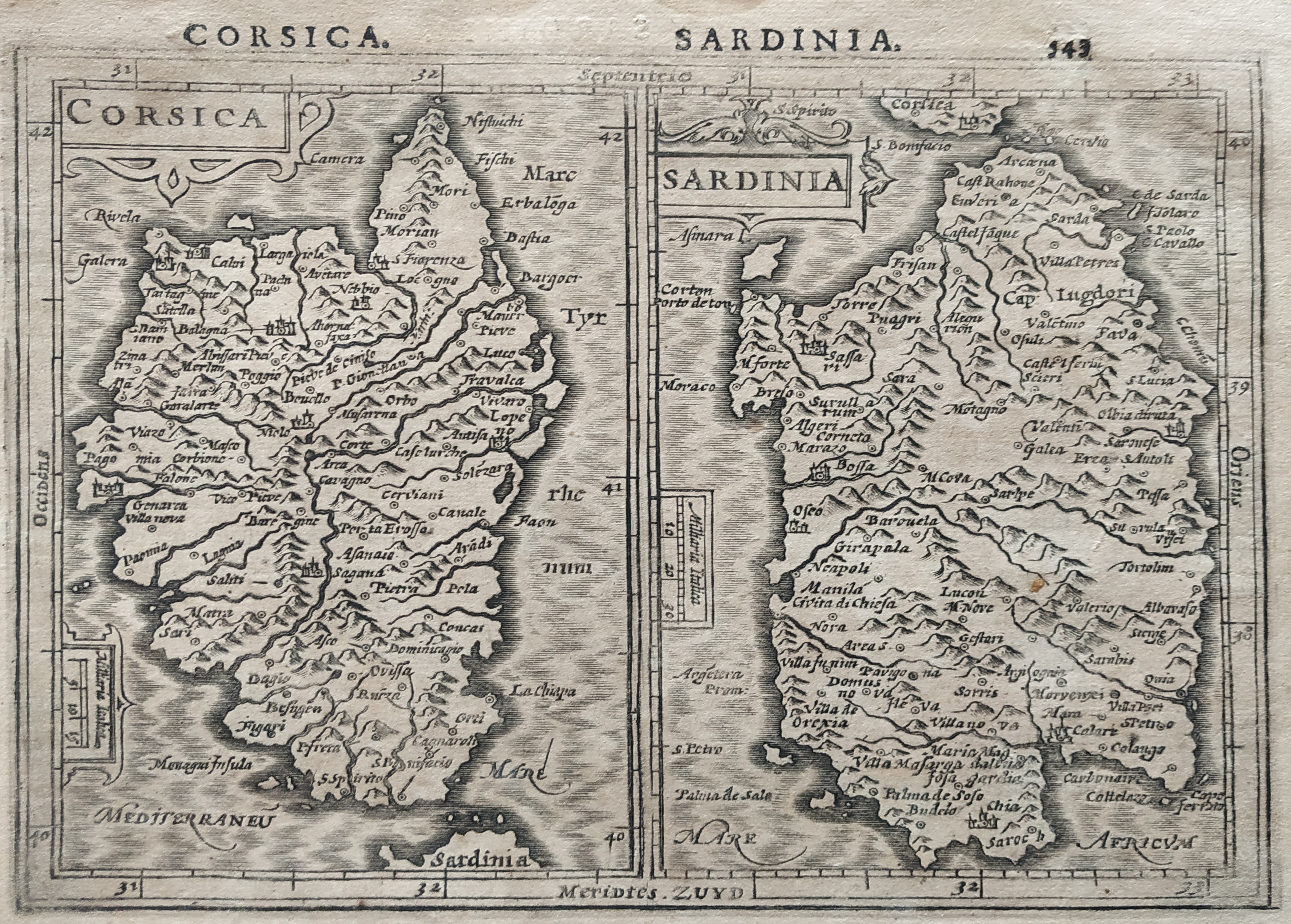
Corsica Sardinia
Author
Mercator
Location shown in map
Sardinia
Edition date
1610
Edition place
Amsterdam
Editor
Houndius
Atlas
Altas Minor Gerardi Mercatoris
Price
200 Euro
State
[mint/EXCELLENT/very good/good/fair/mediocre/poor]
Color
Black/white
Verso
Latin text 544
Size
Plate: cm (19 x 15) inches (7.48 x 5.91) Paper: cm (21 x 17.5) inches (8.27 x 6.89)
Technique
Copper engraving
Note
No particular notes for this maps.
Reference
Wiki
Here for more info
In stock
Available
Info
info@thetreasuremaps.com
Code
#0782
×
![Corsica Sardinia by Mercator, Sardinia, 1610]()
Map title
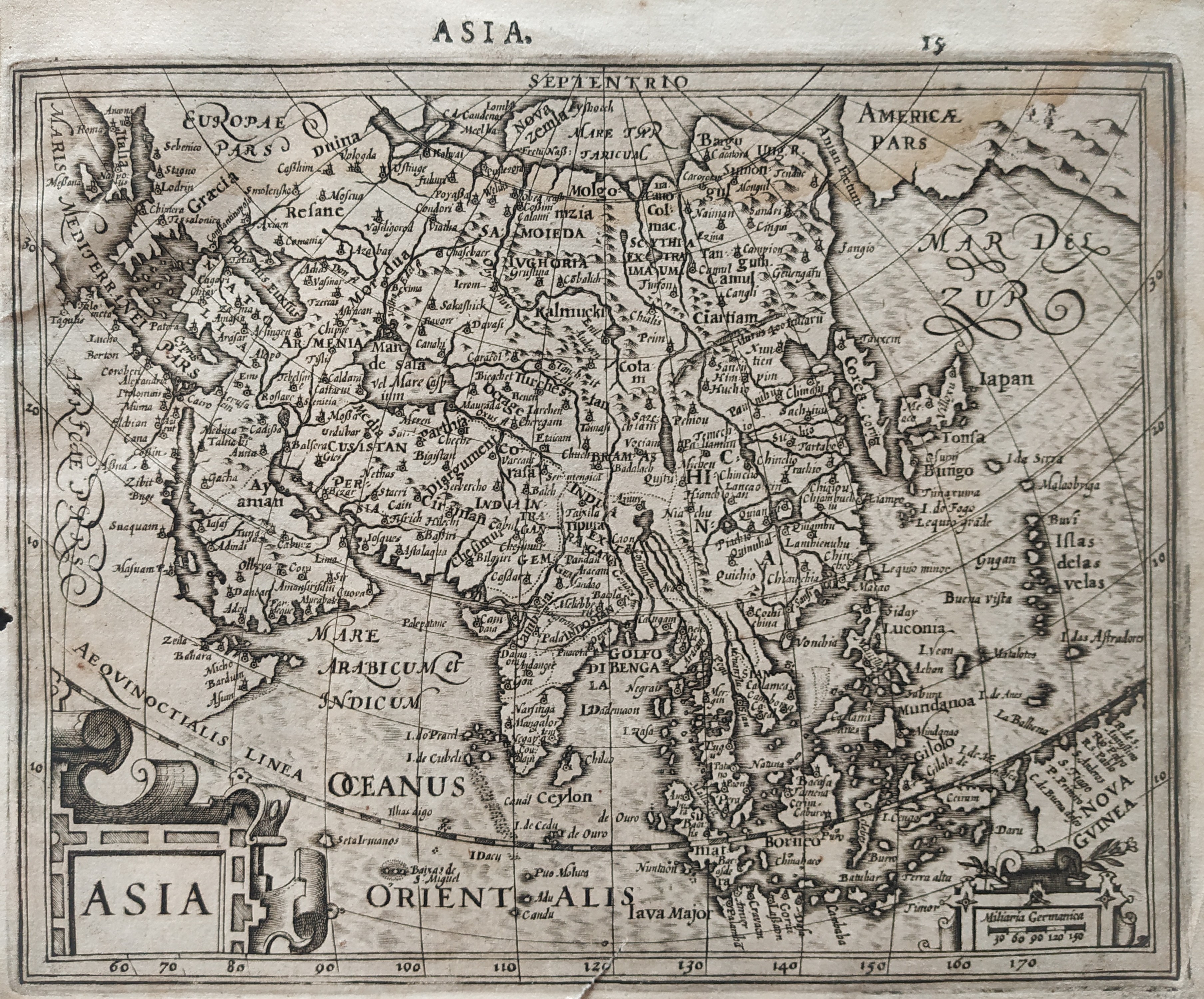
Asia
Author
Mercator
Location shown in map
Asia
Edition date
1610
Edition place
Amsterdam
Editor
Houndius
Atlas
Altas Minor Gerardi Mercatoris
Price
200 Euro
State
[mint/EXCELLENT/very good/good/fair/mediocre/poor]
Color
Black/white
Verso
Latin text 16
Size
Plate: cm (19 x 15) inches (7.48 x 5.91) Paper: cm (21 x 17.5) inches (8.27 x 6.89)
Technique
Copper engraving
Note
No particular notes for this maps.
Reference
Wiki
Here for more info
In stock
Available
Info
info@thetreasuremaps.com
Code
#0781
Asia
Author
Mercator
Location shown in map
Asia
Edition date
1610
Edition place
Amsterdam
Editor
Houndius
Atlas
Altas Minor Gerardi Mercatoris
Price
200 Euro
State
[mint/EXCELLENT/very good/good/fair/mediocre/poor]
Color
Black/white
Verso
Latin text 16
Size
Plate: cm (19 x 15) inches (7.48 x 5.91) Paper: cm (21 x 17.5) inches (8.27 x 6.89)
Technique
Copper engraving
Note
No particular notes for this maps.
Reference
Wiki
Here for more info
In stock
Available
Info
info@thetreasuremaps.com
Code
#0781
×
![Asia by Mercator, Asia, 1610]()
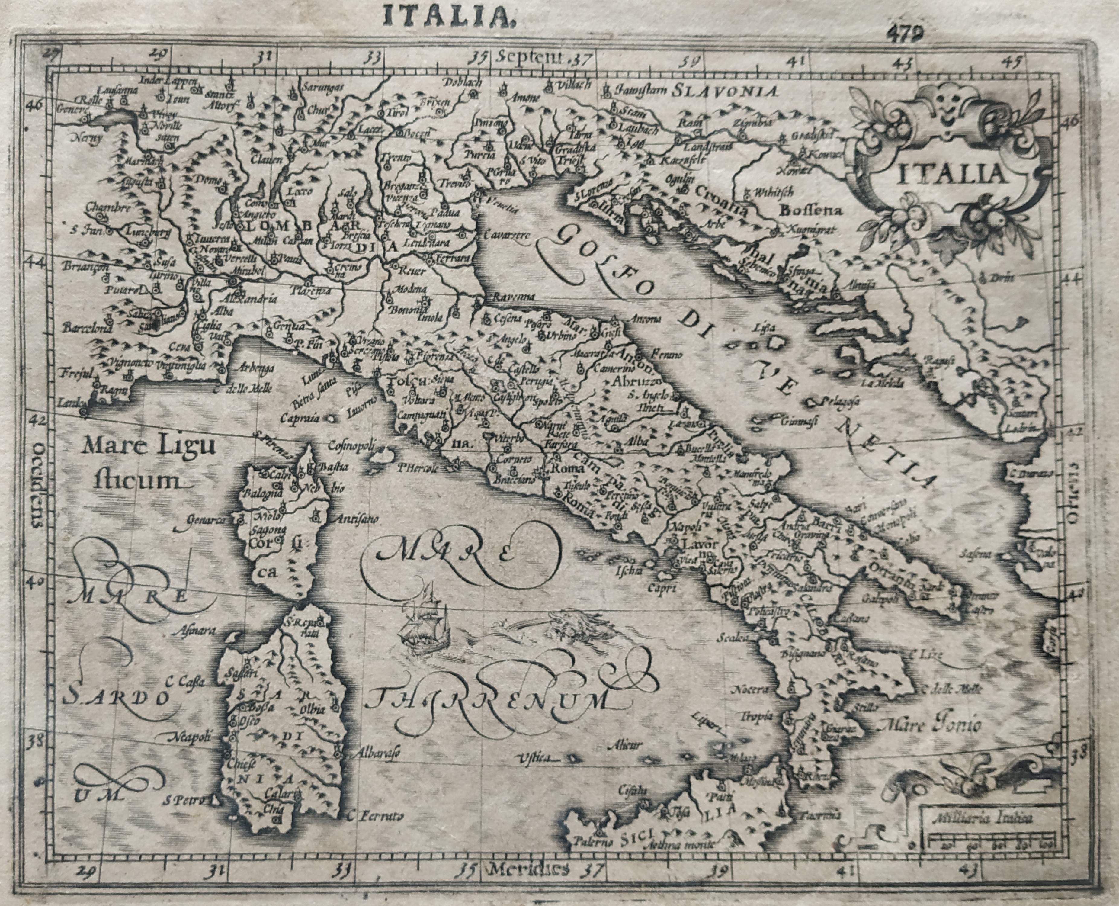
Map title
Italia
Author
Mercator
Location shown in map
Italy
Edition date
1610
Edition place
Amsterdam
Editor
Houndius
Atlas
Altas Minor Gerardi Mercatoris
Price
250 Euro
State
[mint/EXCELLENT/very good/good/fair/mediocre/poor]
Color
Black/white
Verso
Latin text 480
Size
Plate: cm (19 x 15) inches (7.48 x 5.91) Paper: cm (21 x 17.5) inches (8.27 x 6.89)
Technique
Copper engraving
Note
Reference
R.Borri L'Italia nelle antiche carte pag.66
Wiki
Here for more info
In stock
Available
Info
info@thetreasuremaps.com
Code
#0783
×
![Italia by Mercator, Italy, 1610]()

Map title
Japonia
Author
Hondius
Location shown in map
Japan
Edition date
Circa 1611
Edition place
Amsterdam
Editor
Hondius
Atlas
Atlas sive Cosmographicae Meditationes de Fabrica Mundi et Fabricati Figura.
Price
1600 Euro
State
[mint/EXCELLENT/very good/good/fair/mediocre/poor]
Color
Old colors
Verso
Latin pag 360
Size
Plate: cm (45 x 35) inches (17.72 x 13.78) Paper: cm (54 x 42) inches (21.26 x 16.54)
Technique
Copper engraving
Note
Reference
Wiki
Here for more info
In stock
Available
Info
info@thetreasuremaps.com
Code
#1343
×
![Japonia by Hondius, Japan, Circa 1611]()
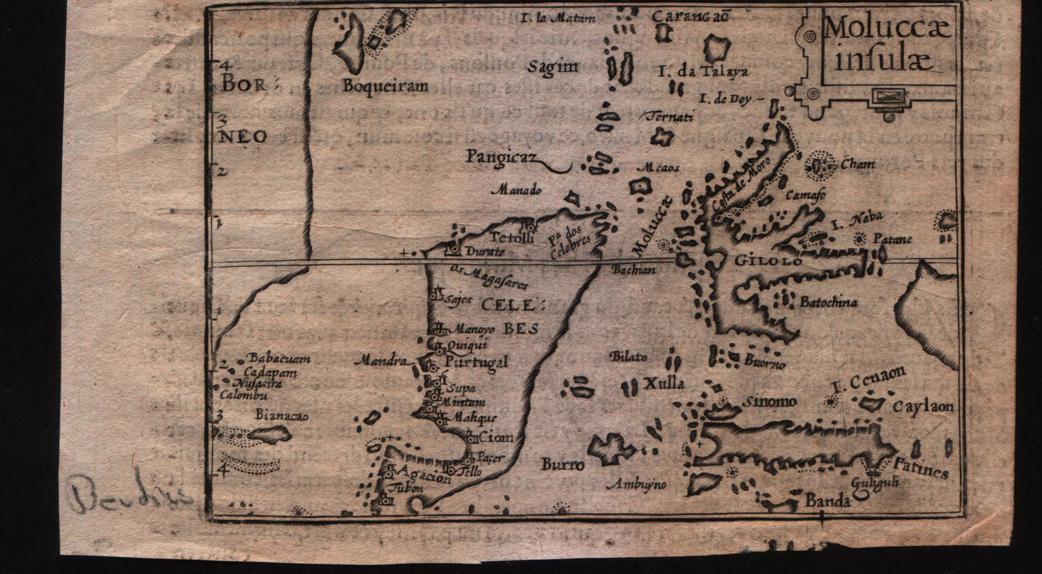
Map title
Moluccae insulae
Author
Bertius
Location shown in map
Moluccas
Edition date
Circa 1612
Edition place
Amsterdam
Editor
Jodocus Hondius
Atlas
Tabularum geographicarum contractarum
Price
Please ask: info@thetreasuremaps.com
State
[MINT/excellent/very good/good/fair/mediocre/poor]
Color
Black/white
Verso
French text pag 58
Size
Plate: cm (12.7 x 8.9) inches (5 x 3.5) Paper: cm (16.5 x 10.2) inches (6.5 x 4.02)
Technique
Copper engraving
Note
--
Reference
--
Wiki
Here for more info
In stock
Available
Info
info@thetreasuremaps.com
Code
#0596
×
![Moluccae insulae by Bertius, Moluccas, Circa 1612]()
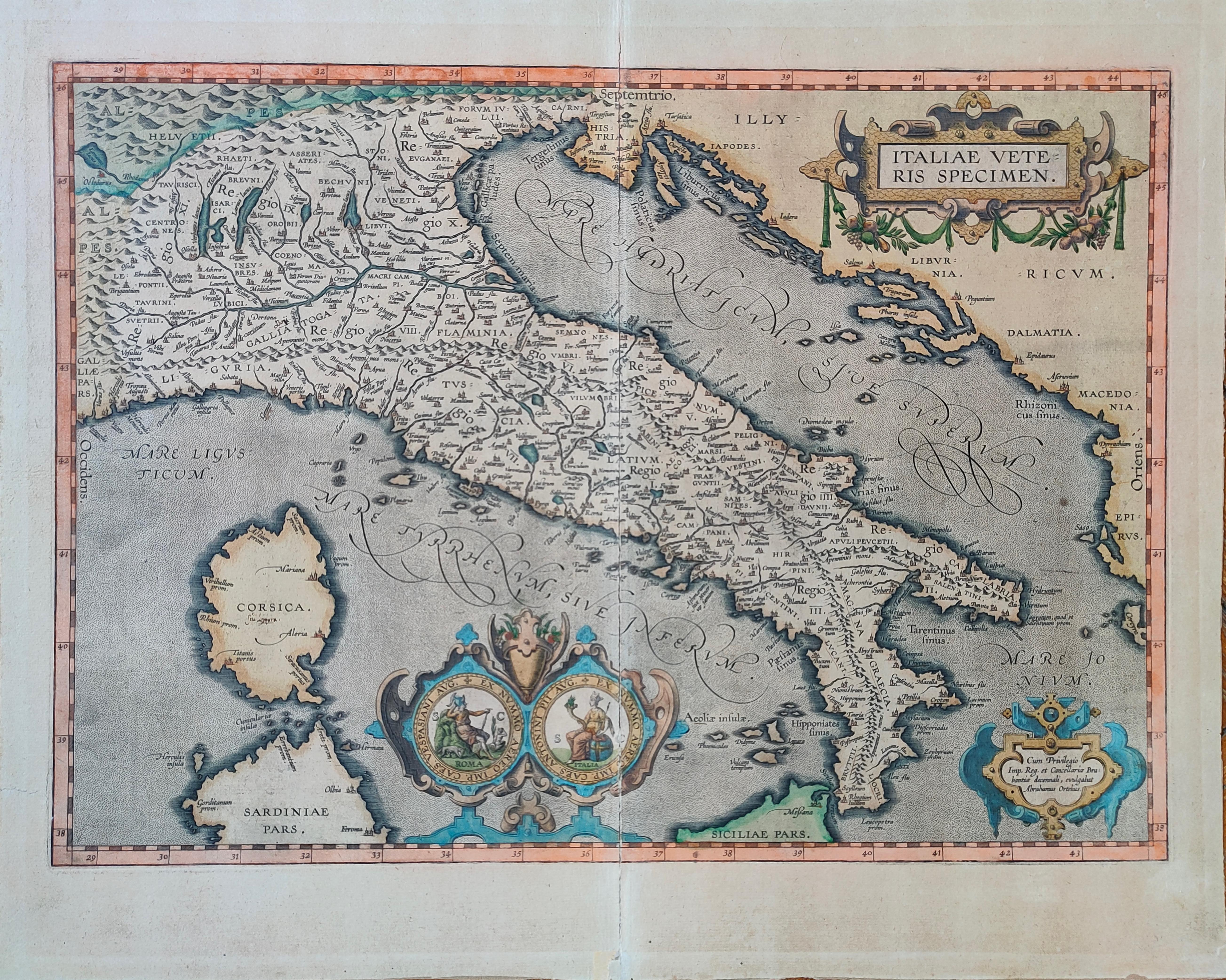
Map title
Italiae Veteris Speciem
Author
Ortelius
Location shown in map
Italy
Edition date
1612
Edition place
Antwerp
Editor
--
Atlas
Epitome theatri Orteliani
Price
900 Euro
State
[mint/EXCELLENT/very good/good/fair/mediocre/poor]
Color
Old colors
Verso
Latin Text pag.xx
Size
Plate: cm (48 x 35) inches (18.9 x 13.78) Paper: cm (55 x 43) inches (21.65 x 16.93)
Technique
Copper engraving
Note
Reference
Van Den Broecke 257
Wiki
Here for more info
In stock
Available
Info
info@thetreasuremaps.com
Code
#1272
×
![Italiae Veteris Speciem by Ortelius, Italy, 1612]()
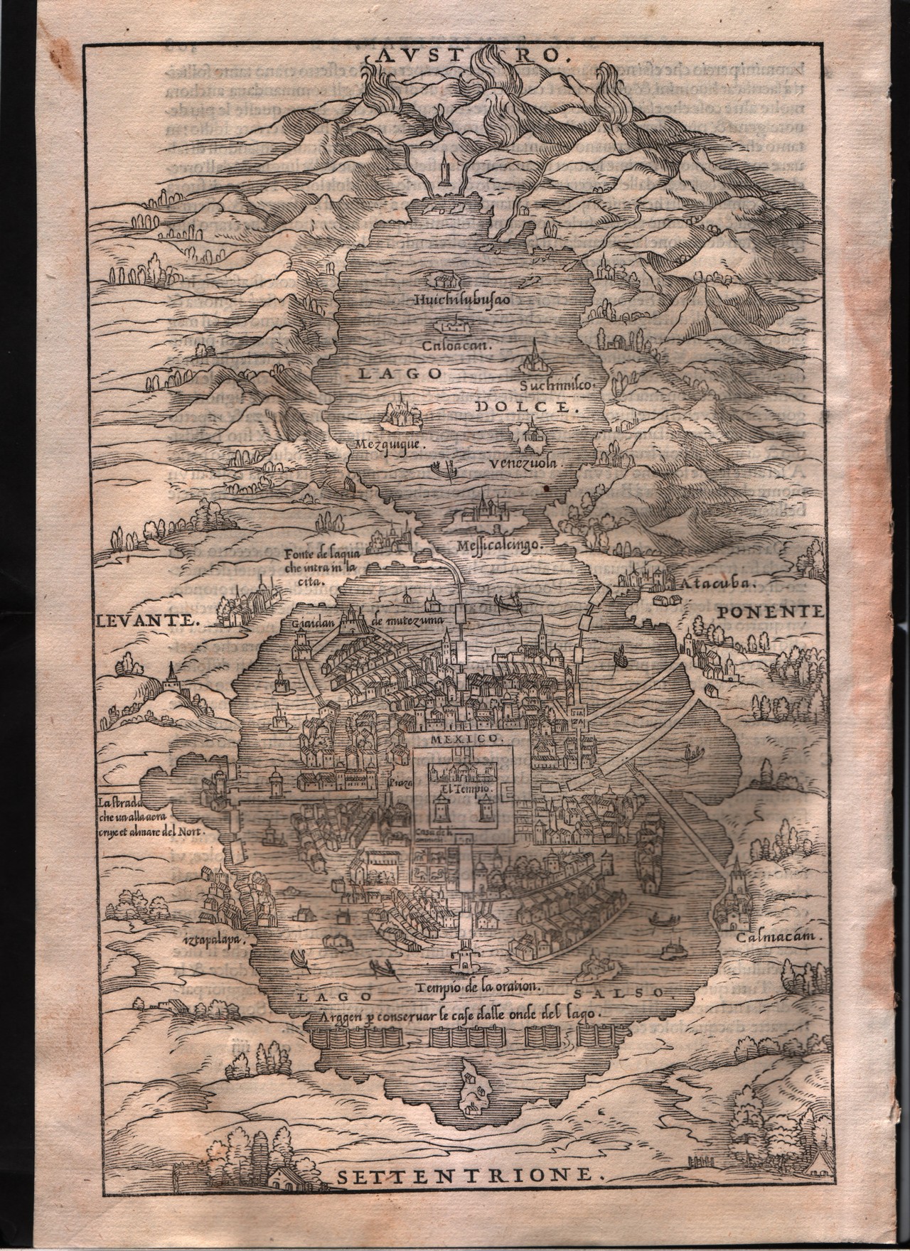
Map title
--
Author
Gastaldi
Location shown in map
Mexico city
Edition date
1613
Edition place
Venice
Editor
Giambattista Ramusio
Atlas
Delle navigazioni e viaggi
Price
200 Euro
State
[mint/EXCELLENT/very good/good/fair/mediocre/poor]
Color
Black/white
Verso
Italian text pag.309
Size
Plate: cm (17.8 x 26.7) inches (7.01 x 10.51) Paper: cm (20.3 x 30.5) inches (7.99 x 12.01)
Technique
Woodcut
Note
--
Reference
--
Wiki
Here for more info
In stock
Sold
Info
info@thetreasuremaps.com
Code
#0339
--
Author
Gastaldi
Location shown in map
Mexico city
Edition date
1613
Edition place
Venice
Editor
Giambattista Ramusio
Atlas
Delle navigazioni e viaggi
Price
200 Euro
State
[mint/EXCELLENT/very good/good/fair/mediocre/poor]
Color
Black/white
Verso
Italian text pag.309
Size
Plate: cm (17.8 x 26.7) inches (7.01 x 10.51) Paper: cm (20.3 x 30.5) inches (7.99 x 12.01)
Technique
Woodcut
Note
--
Reference
--
Wiki
Here for more info
In stock
Sold
Info
info@thetreasuremaps.com
Code
#0339
×
![-- by Gastaldi, Mexico city, 1613]()
Map title
Isola Spaguola
Author
Gastaldi
Location shown in map
Haiti island
Edition date
1613
Edition place
Venice
Editor
Giambattista Ramusio
Atlas
Delle navigazioni e viaggi
Price
500 Euro
State
[mint/EXCELLENT/very good/good/fair/mediocre/poor]
Color
Black/white
Verso
Italian text pag.36
Size
Plate: cm (26.7 x 17.8) inches (10.51 x 7.01) Paper: cm (31.8 x 21.6) inches (12.52 x 8.5)
Technique
Woodcut
Note
Decorated with sea monsters and sailing ships.
Reference
--
Wiki
Here for more info
In stock
Available
Info
info@thetreasuremaps.com
Code
#0338
×
![Isola Spaguola by Gastaldi, Haiti island, 1613]()
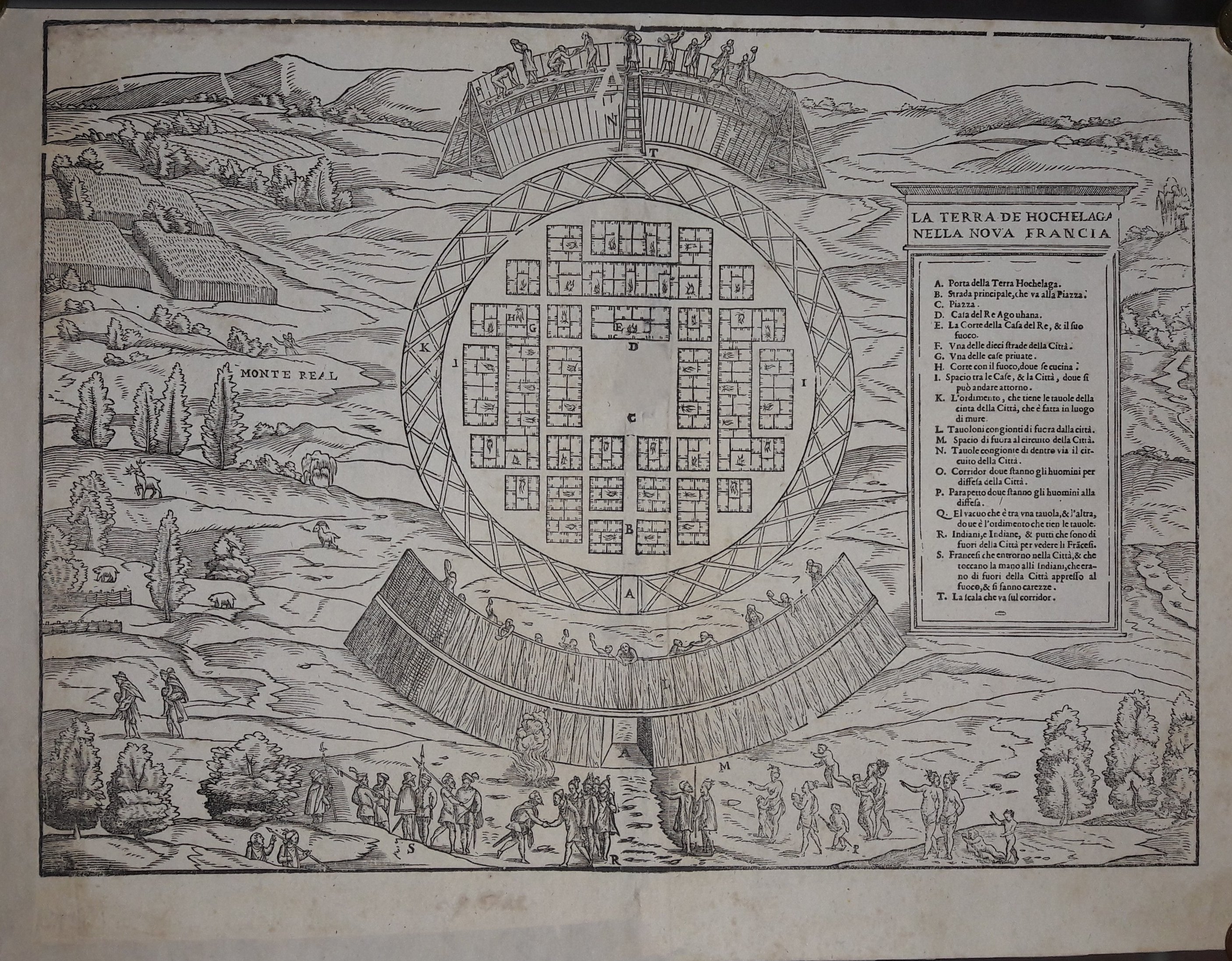
Map title
La terra de Hochelaga nella nuova Francia
Author
Gastaldi
Location shown in map
Canada
Edition date
1613
Edition place
Venice
Editor
Giambattista Ramusio
Atlas
Delle navigazioni e viaggi
Price
1500 Euro
State
[mint/EXCELLENT/very good/good/fair/mediocre/poor] professionally restored
Color
Black/white
Verso
Blank
Size
Plate: cm (35.6 x 26.7) inches (14.02 x 10.51) Paper: cm (40.6 x 30.5) inches (15.98 x 12.01)
Technique
Woodcut
Note
--
Reference
--
Wiki
Here for more info
In stock
Sold
Info
info@thetreasuremaps.com
Code
#0546
×
![La terra de Hochelaga nella nuova Francia by Gastaldi, Canada, 1613]()
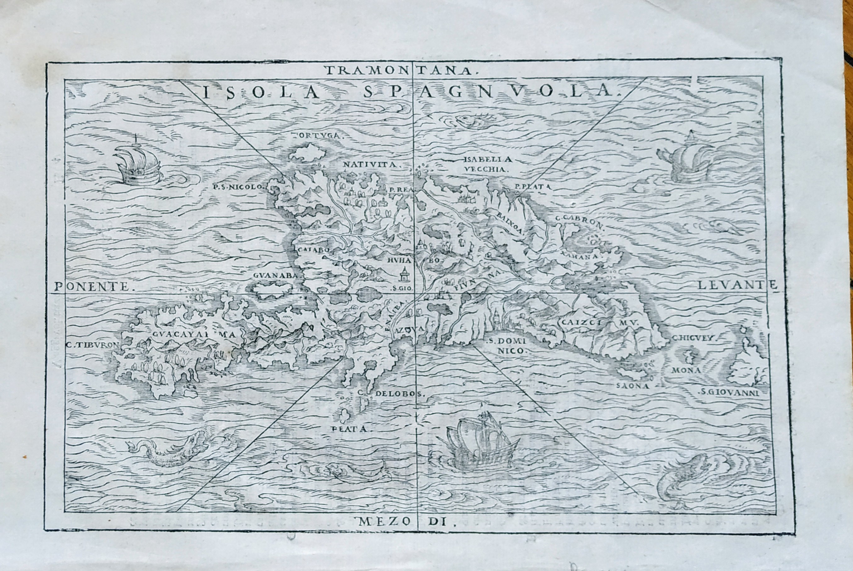
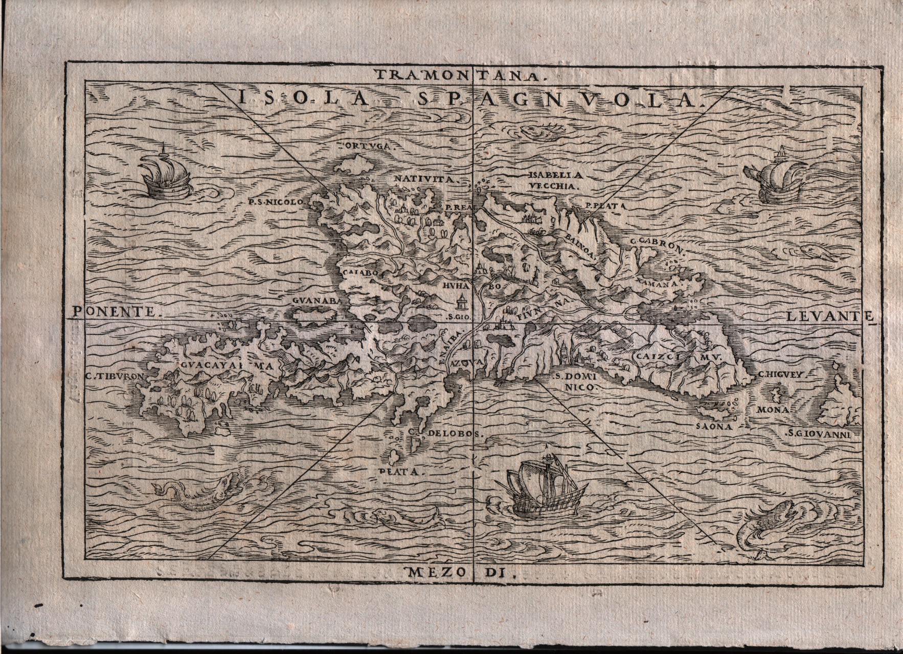
Map title
Isola Spaguola
Author
Gastaldi
Location shown in map
Haiti island
Edition date
1613
Edition place
Venice
Editor
Giambattista Ramusio
Atlas
Delle navigazioni e viaggi
Price
500 Euro
State
[mint/EXCELLENT/very good/good/fair/mediocre/poor]
Color
Black/white
Verso
Italian text pag.36
Size
Plate: cm (26.7 x 17.8) inches (10.51 x 7.01) Paper: cm (31.8 x 21.6) inches (12.52 x 8.5)
Technique
Woodcut
Note
Decorated with sea monsters and sailing ships.
Reference
--
Wiki
Here for more info
In stock
Available
Info
info@thetreasuremaps.com
Code
#0729
×
![Isola Spaguola by Gastaldi, Haiti island, 1613]()
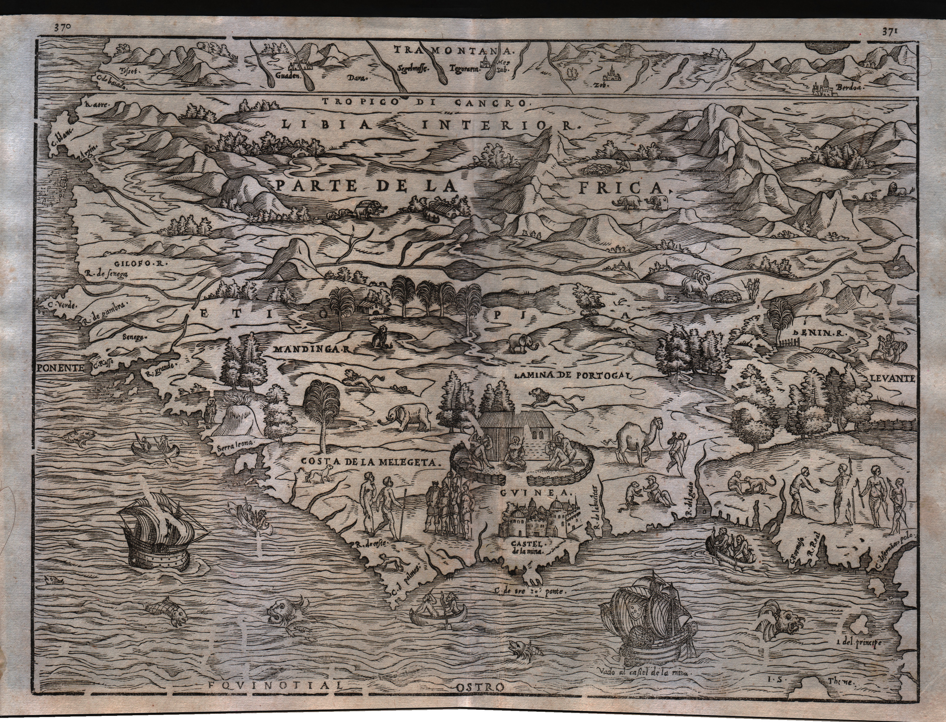
Map title
--
Author
Gastaldi
Location shown in map
Guinea
Edition date
1613
Edition place
Venice
Editor
Giambattista Ramusio
Atlas
Delle navigazioni e viaggi
Price
Please ask: info@thetreasuremaps.com
State
[mint/EXCELLENT/very good/good/fair/mediocre/poor]
Color
Black/white
Verso
Blank
Size
Plate: cm (35.6 x 26.7) inches (14.02 x 10.51) Paper: cm (39.4 x 30.5) inches (15.51 x 12.01)
Technique
Woodcut
Note
Decorated with sea monsters and sailing ships.
Reference
--
Wiki
Here for more info
In stock
Available
Info
info@thetreasuremaps.com
Code
#0545
--
Author
Gastaldi
Location shown in map
Guinea
Edition date
1613
Edition place
Venice
Editor
Giambattista Ramusio
Atlas
Delle navigazioni e viaggi
Price
Please ask: info@thetreasuremaps.com
State
[mint/EXCELLENT/very good/good/fair/mediocre/poor]
Color
Black/white
Verso
Blank
Size
Plate: cm (35.6 x 26.7) inches (14.02 x 10.51) Paper: cm (39.4 x 30.5) inches (15.51 x 12.01)
Technique
Woodcut
Note
Decorated with sea monsters and sailing ships.
Reference
--
Wiki
Here for more info
In stock
Available
Info
info@thetreasuremaps.com
Code
#0545
×
![-- by Gastaldi, Guinea, 1613]()
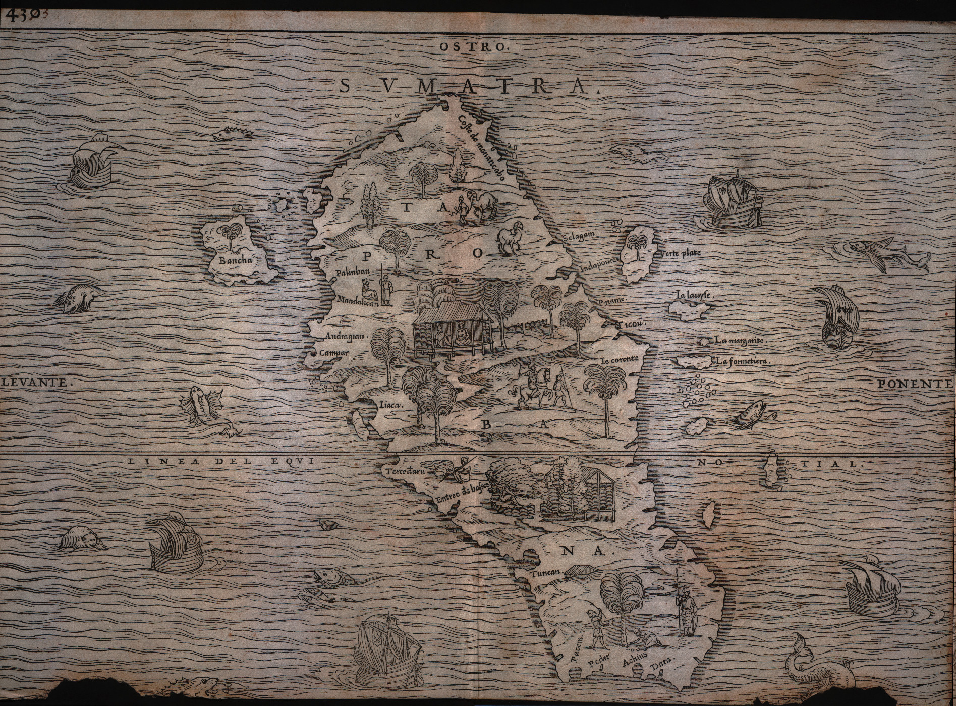
Map title
Sumatra
Author
Gastaldi
Location shown in map
Sumatra
Edition date
1613
Edition place
Venice
Editor
Giambattista Ramusio
Atlas
Delle navigazioni e viaggi
Price
Please ask: info@thetreasuremaps.com
State
[mint/excellent/very good/good/FAIR/mediocre/poor]
Color
Black/white
Verso
pag.430
Size
Plate: cm (36.8 x 26.7) inches (14.49 x 10.51) Paper: cm (36.8 x 26.7) inches (14.49 x 10.51)
Technique
Woodcut
Note
Decorated with sea monsters and sailing ships.
Reference
--
Wiki
Here for more info
In stock
Available
Info
info@thetreasuremaps.com
Code
#0179
Sumatra
Author
Gastaldi
Location shown in map
Sumatra
Edition date
1613
Edition place
Venice
Editor
Giambattista Ramusio
Atlas
Delle navigazioni e viaggi
Price
Please ask: info@thetreasuremaps.com
State
[mint/excellent/very good/good/FAIR/mediocre/poor]
Color
Black/white
Verso
pag.430
Size
Plate: cm (36.8 x 26.7) inches (14.49 x 10.51) Paper: cm (36.8 x 26.7) inches (14.49 x 10.51)
Technique
Woodcut
Note
Decorated with sea monsters and sailing ships.
Reference
--
Wiki
Here for more info
In stock
Available
Info
info@thetreasuremaps.com
Code
#0179
×
![Sumatra by Gastaldi, Sumatra, 1613]()
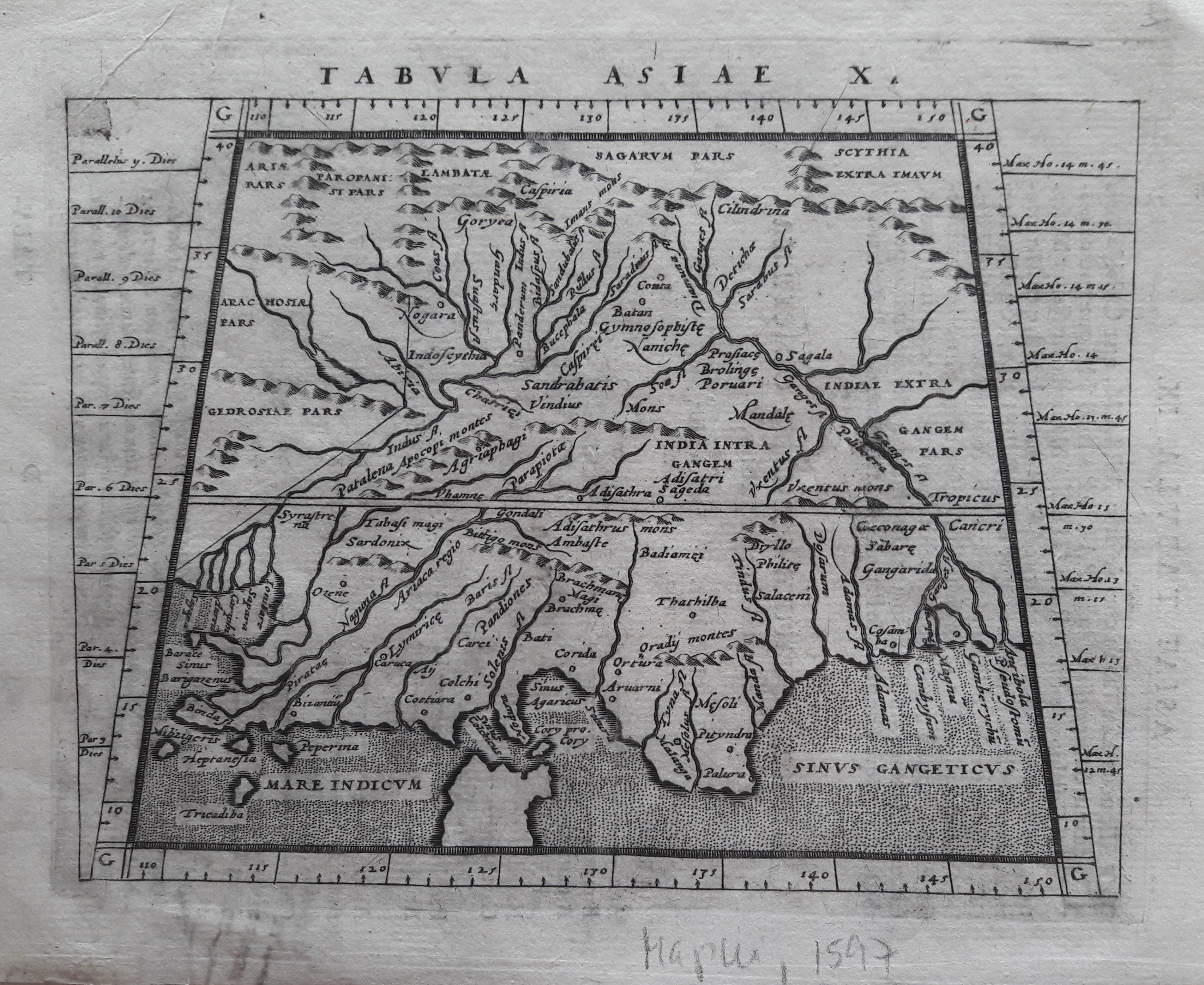
Map title
Tabula Asiae X
Author
Magini
Location shown in map
Indie
Edition date
1617
Edition place
Arnheim
Editor
Ioannes Ianssonius
Atlas
Geografia di Claudio Tolomeo -- Giovanni Antonio Magini
Price
Please ask: info@thetreasuremaps.com
State
[mint/EXCELLENT/very good/good/fair/mediocre/poor]
Color
Black/white
Verso
Latin text pag 25
Size
Plate: cm (17.8 x 12.7) inches (7.01 x 5) Paper: cm (21.6 x 17.8) inches (8.5 x 7.01)
Technique
Copper engraving
Note
No particular notes for this maps.
Reference
--
Wiki
Here for more info
In stock
Available
Info
info@thetreasuremaps.com
Code
#0643
×
![Tabula Asiae X by Magini, Indie, 1617]()
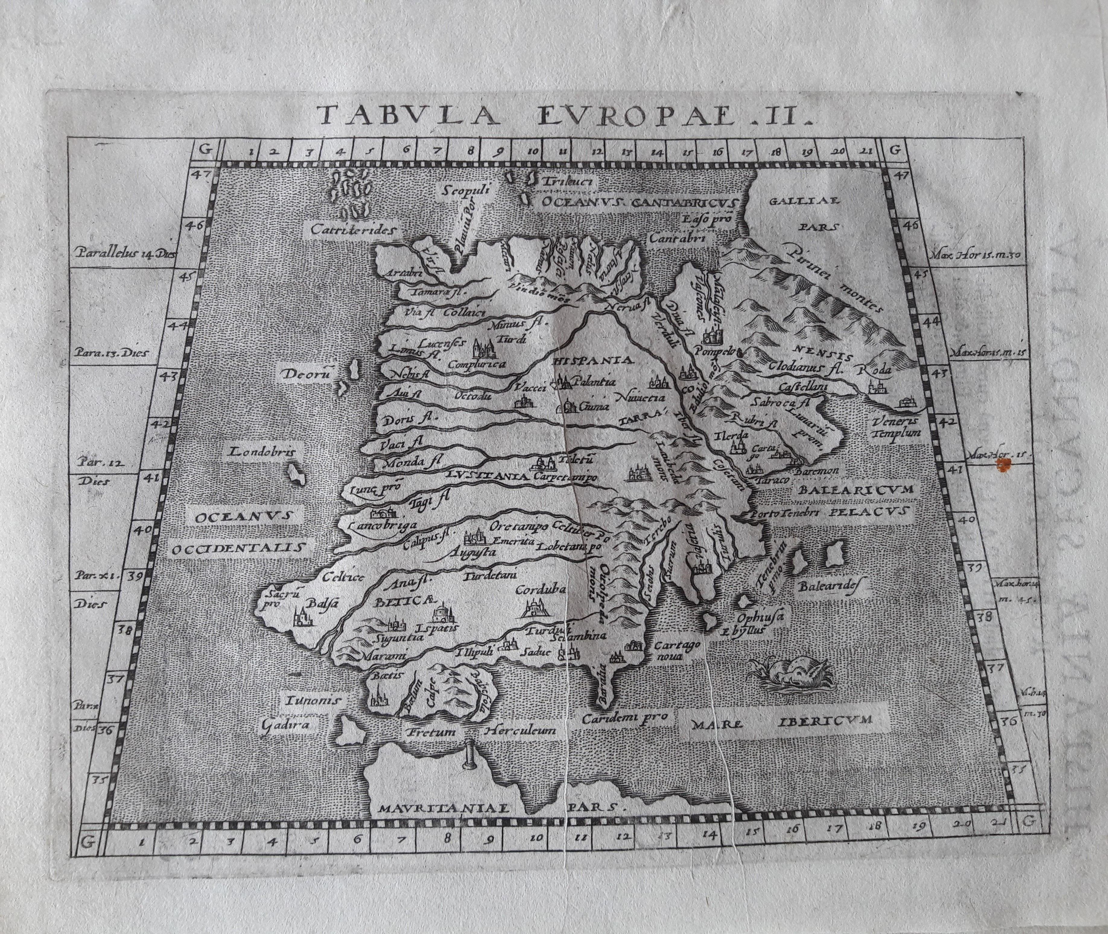
Map title
Tabula Europae II
Author
Magini
Location shown in map
Spain
Edition date
1617
Edition place
Arnheim
Editor
Ioannes Ianssonius
Atlas
Geografia di Claudio Tolomeo -- Giovanni Antonio Magini
Price
Please ask: info@thetreasuremaps.com
State
[mint/EXCELLENT/very good/good/fair/mediocre/poor]
Color
Black/white
Verso
Latin text pag 4
Size
Plate: cm (17.8 x 12.7) inches (7.01 x 5) Paper: cm (21.6 x 17.8) inches (8.5 x 7.01)
Technique
Copper engraving
Note
No particular notes for this maps.
Reference
--
Wiki
Here for more info
In stock
Available
Info
info@thetreasuremaps.com
Code
#0650
×
![Tabula Europae II by Magini, Spain, 1617]()
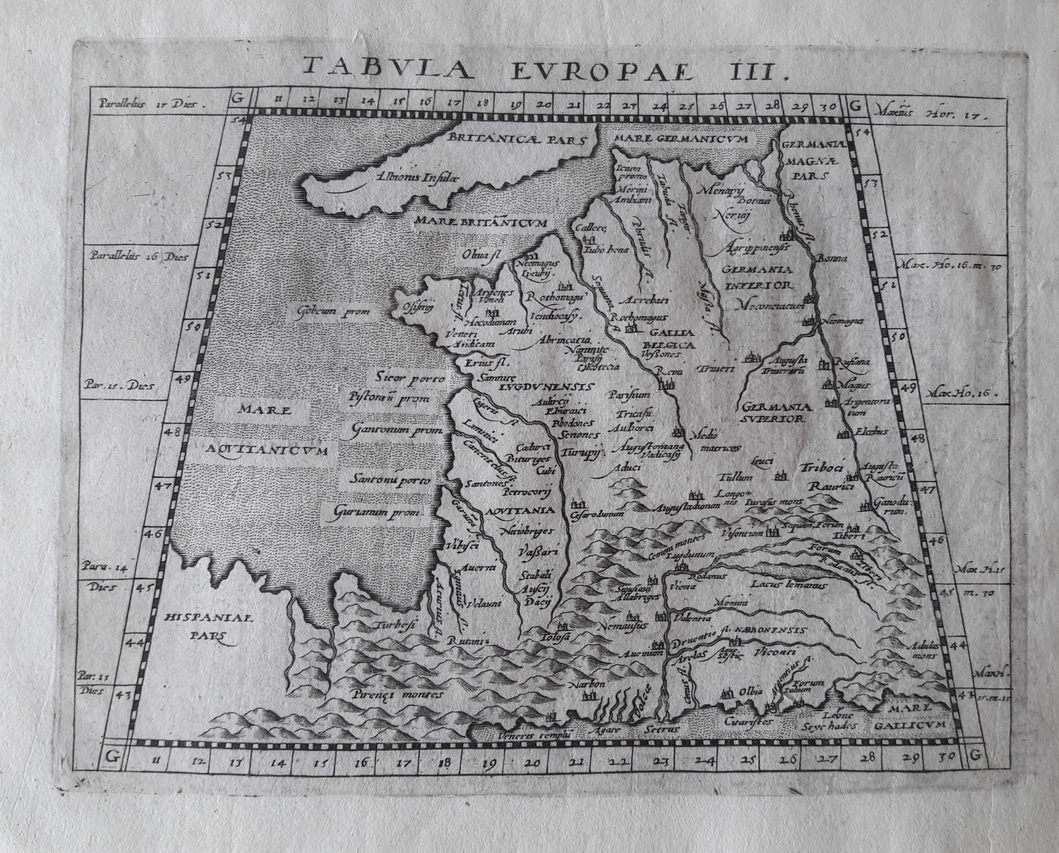
Map title
Tabula Europae III
Author
Magini
Location shown in map
France
Edition date
1617
Edition place
Arnheim
Editor
Ioannes Ianssonius
Atlas
Geografia di Claudio Tolomeo -- Giovanni Antonio Magini
Price
Please ask: info@thetreasuremaps.com
State
[mint/EXCELLENT/very good/good/fair/mediocre/poor]
Color
Black/white
Verso
Latin text pag 3
Size
Plate: cm (17.8 x 12.7) inches (7.01 x 5) Paper: cm (21.6 x 17.8) inches (8.5 x 7.01)
Technique
Copper engraving
Note
No particular notes for this maps.
Reference
--
Wiki
Here for more info
In stock
Available
Info
info@thetreasuremaps.com
Code
#0649
×
![Tabula Europae III by Magini, France, 1617]()
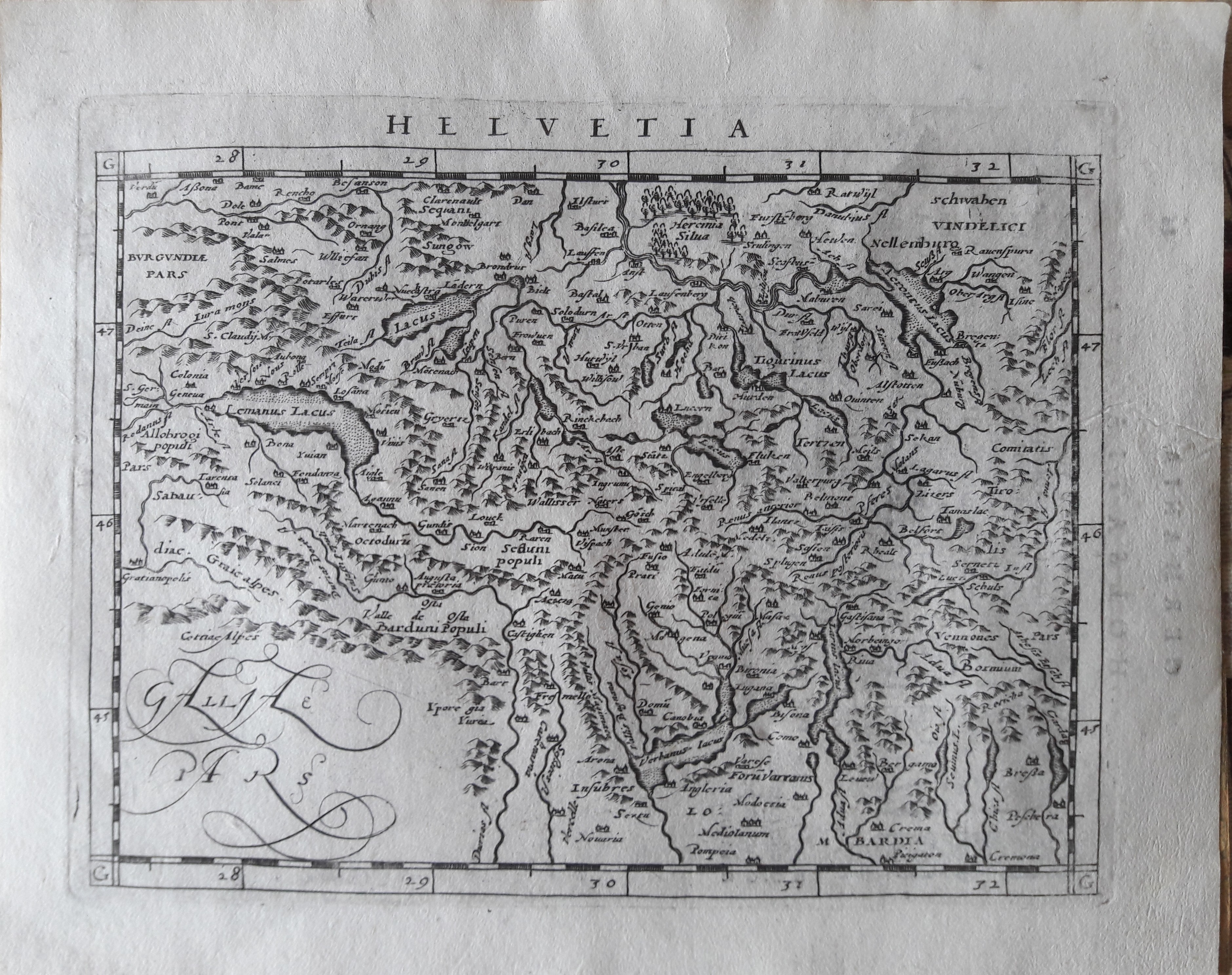
Map title
Helvetia
Author
Magini
Location shown in map
Switzerland
Edition date
1617
Edition place
Arnheim
Editor
Ioannes Ianssonius
Atlas
Geografia di Claudio Tolomeo -- Giovanni Antonio Magini
Price
300 Euro
State
[mint/EXCELLENT/very good/good/fair/mediocre/poor]
Color
Black/white
Verso
Latin text pag 86
Size
Plate: cm (17.8 x 12.7) inches (7.01 x 5) Paper: cm (21.6 x 17.8) inches (8.5 x 7.01)
Technique
Copper engraving
Note
Reference
--
Wiki
Here for more info
In stock
Available
Info
info@thetreasuremaps.com
Code
#0647
×
![Helvetia by Magini, Switzerland, 1617]()
Map title
Tabula Europe IIII
Author
Magini
Location shown in map
Germany
Edition date
1617
Edition place
Arnheim
Editor
Ioannes Ianssonius
Atlas
Geografia di Claudio Tolomeo -- Giovanni Antonio Magini
Price
Please ask: info@thetreasuremaps.com
State
[mint/EXCELLENT/very good/good/fair/mediocre/poor]
Color
Black/white
Verso
Latin text pag 5
Size
Plate: cm (17.8 x 12.7) inches (7.01 x 5) Paper: cm (21.6 x 17.8) inches (8.5 x 7.01)
Technique
Copper engraving
Note
No particular notes for this maps.
Reference
--
Wiki
Here for more info
In stock
Available
Info
info@thetreasuremaps.com
Code
#0646
×
![Tabula Europe IIII by Magini, Germany, 1617]()
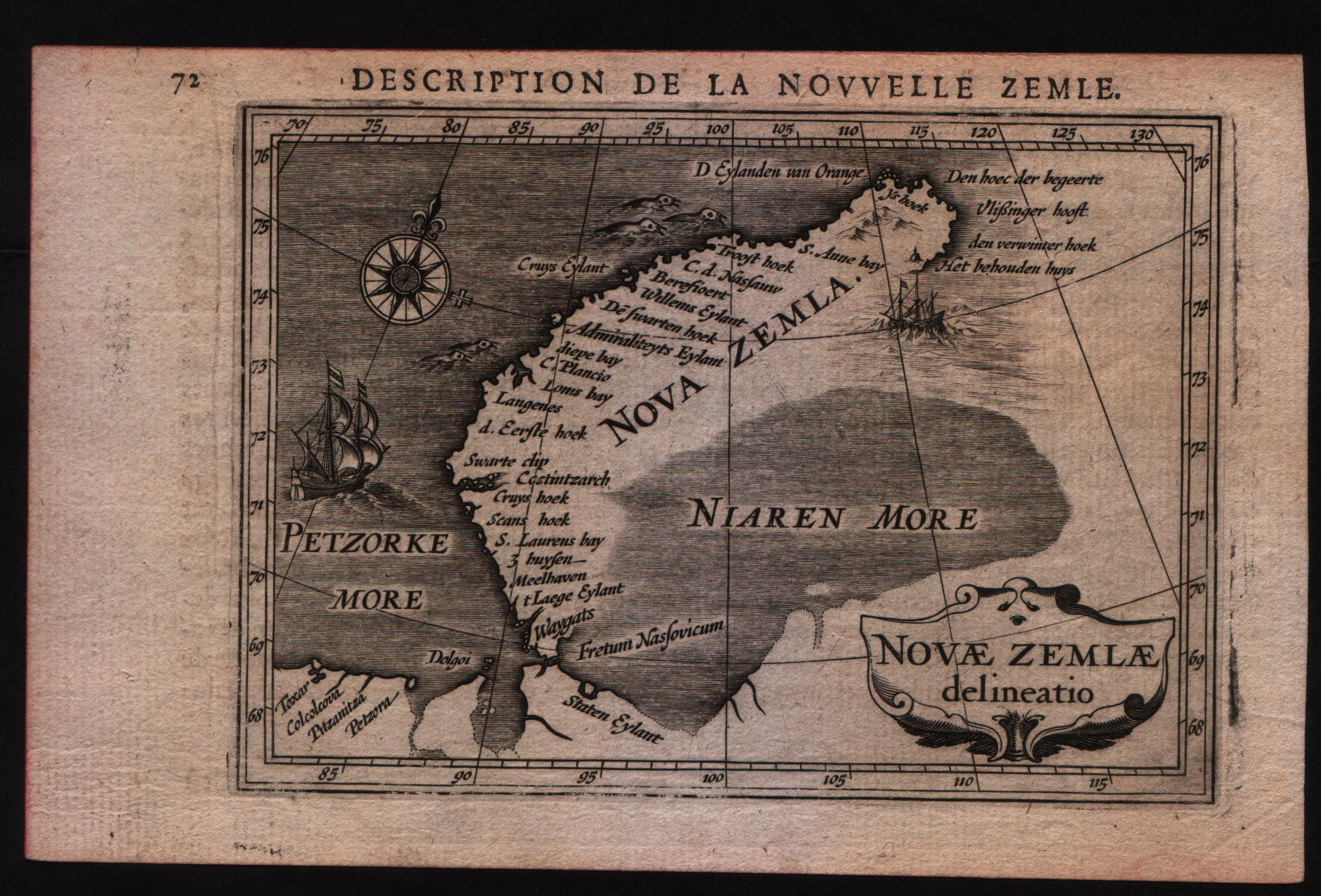
Map title
Description de la nouvelle Zemle
Author
Bertius
Location shown in map
New Zemlia
Edition date
1617
Edition place
Amsterdam
Editor
Jodocus Hondius
Atlas
Tabularum geographicarum contractarum
Price
Please ask: info@thetreasuremaps.com
State
[MINT/excellent/very good/good/fair/mediocre/poor]
Color
Black/white
Verso
French text pag 71
Size
Plate: cm (14 x 10.2) inches (5.51 x 4.02) Paper: cm (17.8 x 11.4) inches (7.01 x 4.49)
Technique
Copper engraving
Note
--
Reference
--
Wiki
Here for more info
In stock
Available
Info
info@thetreasuremaps.com
Code
#0592
×
![Description de la nouvelle Zemle by Bertius, New Zemlia, 1617]()