1600-1699
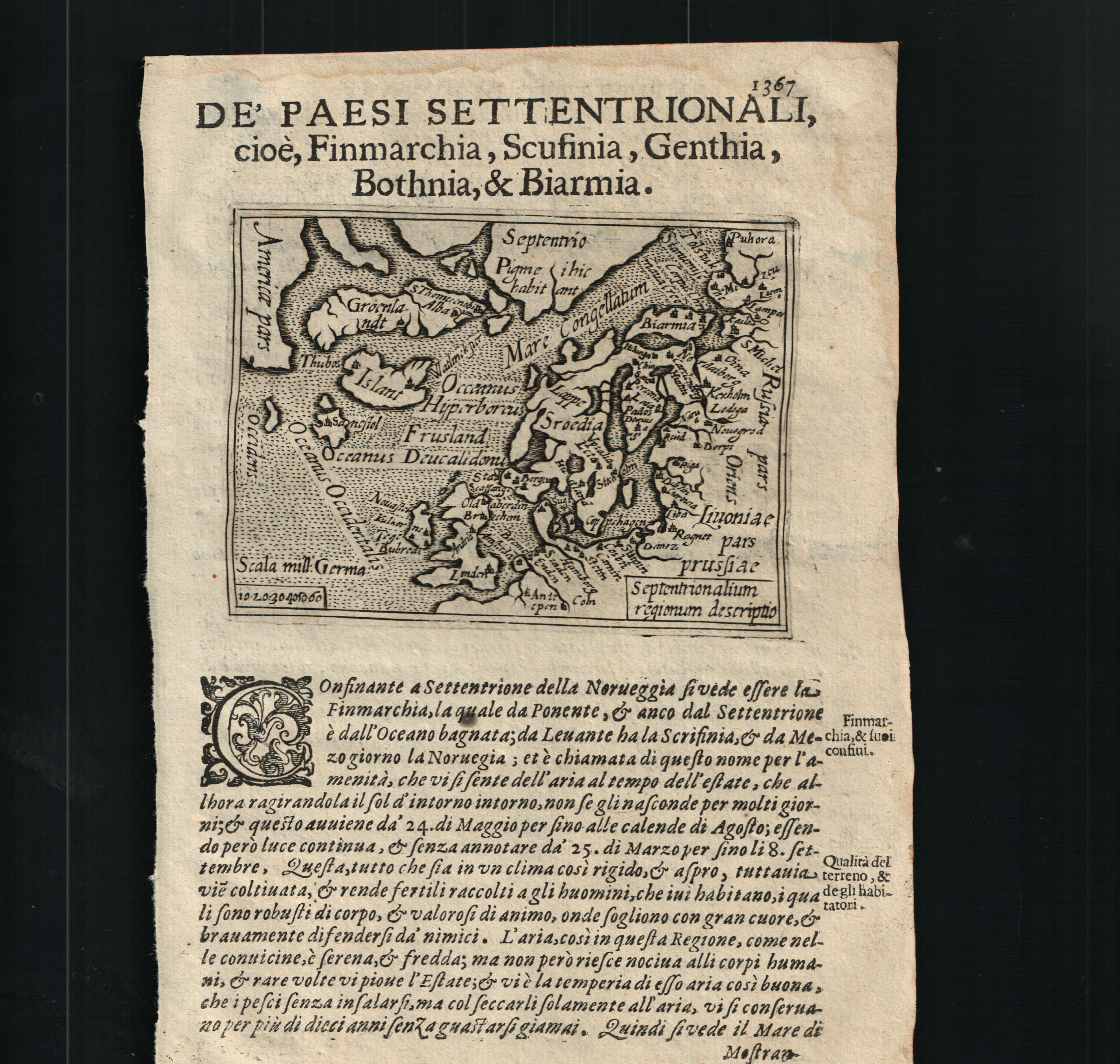
Map title
Septentrionalium regnorum descriptio
Author
Doglioni
Location shown in map
Scandinavia
Edition date
1623
Edition place
Venice
Editor
Giacomo Sarzina
Atlas
Anfiteatro di Europa
Price
700 Euro
State
[mint/EXCELLENT/very good/good/fair/mediocre/poor]
Color
Black/white
Verso
Italian text pag.1368
Size
Plate: cm (11.4 x 8.9) inches (4.49 x 3.5) Paper: cm (15.2 x 22.9) inches (5.98 x 9.02)
Technique
Copper engraving
Note
The maps are copies of the Galle (c.1595) edition of Ortelius.
Reference
--
Wiki
Here for more info
In stock
Available
Info
info@thetreasuremaps.com
Code
#0603
×
![Septentrionalium regnorum descriptio by Doglioni, Scandinavia, 1623]()
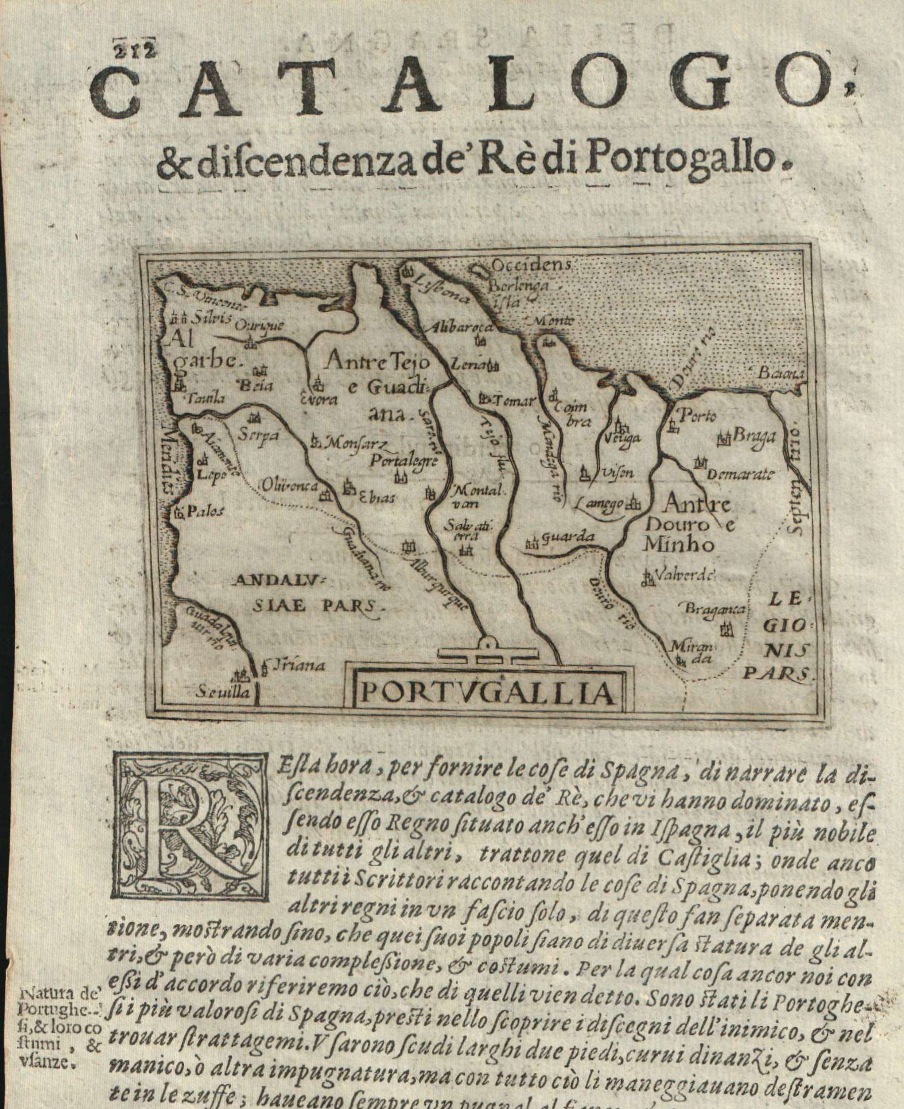
Map title
Portugallia
Author
Doglioni
Location shown in map
Portugal
Edition date
1623
Edition place
Venice
Editor
Giacomo Sarzina
Atlas
Anfiteatro di Europa
Price
Please ask: info@thetreasuremaps.com
State
[mint/EXCELLENT/very good/good/fair/mediocre/poor]
Color
Black/white
Verso
Italian text pag.211
Size
Plate: cm (11.4 x 8.9) inches (4.49 x 3.5) Paper: cm (15.2 x 22.9) inches (5.98 x 9.02)
Technique
Copper engraving
Note
The maps are copies of the Galle (c.1595) edition of Ortelius.
Reference
--
Wiki
Here for more info
In stock
Available
Info
info@thetreasuremaps.com
Code
#0608
×
![Portugallia by Doglioni, Portugal, 1623]()
Map title
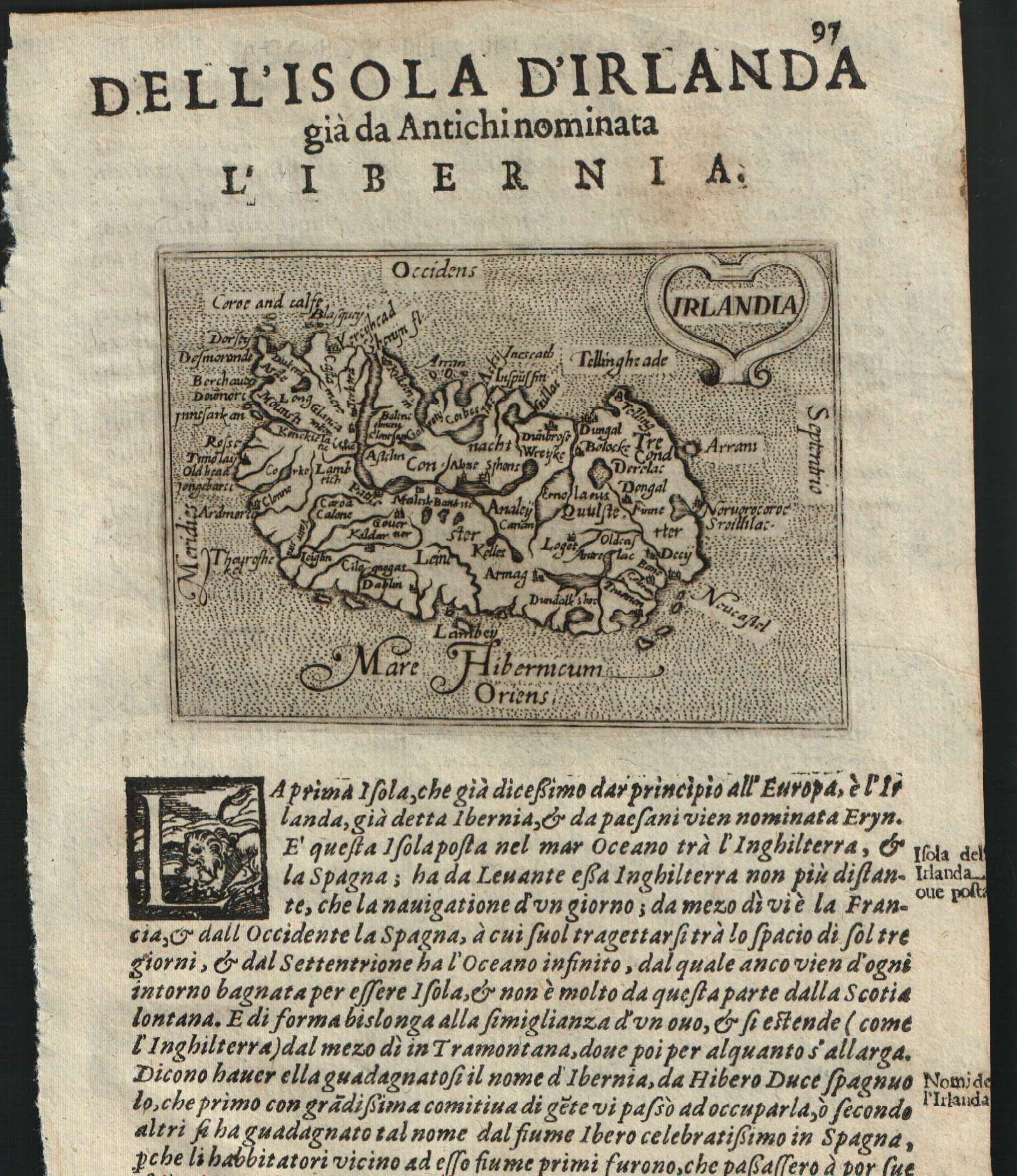
Irlandia
Author
Doglioni
Location shown in map
Ireland
Edition date
1623
Edition place
Venice
Editor
Giacomo Sarzina
Atlas
Anfiteatro di Europa
Price
Please ask: info@thetreasuremaps.com
State
[mint/EXCELLENT/very good/good/fair/mediocre/poor]
Color
Black/white
Verso
Italian text pag.98
Size
Plate: cm (11.4 x 8.9) inches (4.49 x 3.5) Paper: cm (15.2 x 22.9) inches (5.98 x 9.02)
Technique
Copper engraving
Note
The maps are copies of the Galle (c.1595) edition of Ortelius.
Reference
--
Wiki
Here for more info
In stock
Sold
Info
info@thetreasuremaps.com
Code
#0609
×
![Irlandia by Doglioni, Ireland, 1623]()
Map title
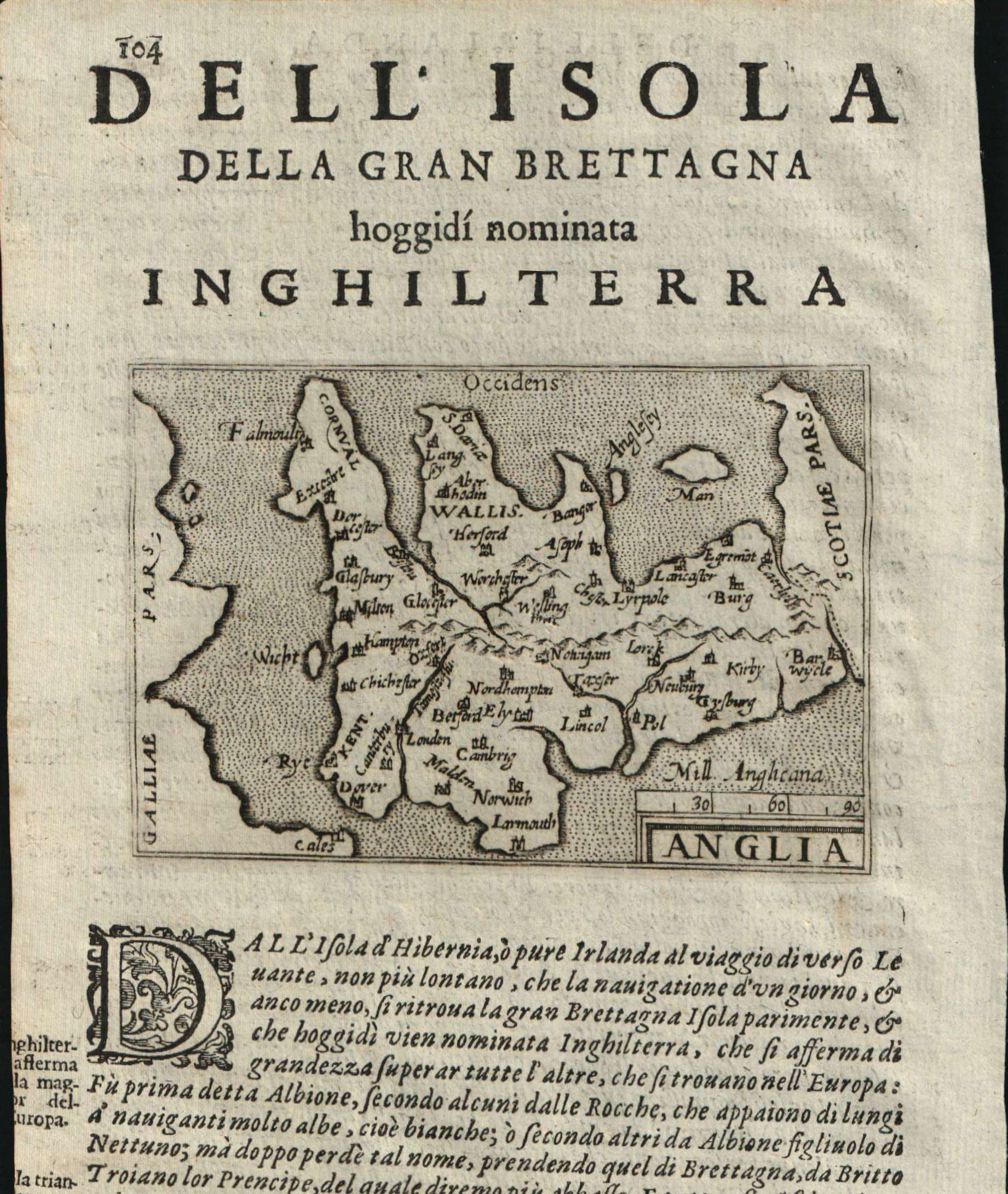
Anglia
Author
Doglioni
Location shown in map
England
Edition date
1623
Edition place
Venice
Editor
Giacomo Sarzina
Atlas
Anfiteatro di Europa
Price
900 Euro
State
[mint/EXCELLENT/very good/good/fair/mediocre/poor]
Color
Black/white
Verso
Italian text pag.103
Size
Plate: cm (11.4 x 8.9) inches (4.49 x 3.5) Paper: cm (15.2 x 22.9) inches (5.98 x 9.02)
Technique
Copper engraving
Note
The maps are copies of the Galle (c.1595) edition of Ortelius.
Reference
--
Wiki
Here for more info
In stock
Available
Info
info@thetreasuremaps.com
Code
#0610
×
![Anglia by Doglioni, England, 1623]()
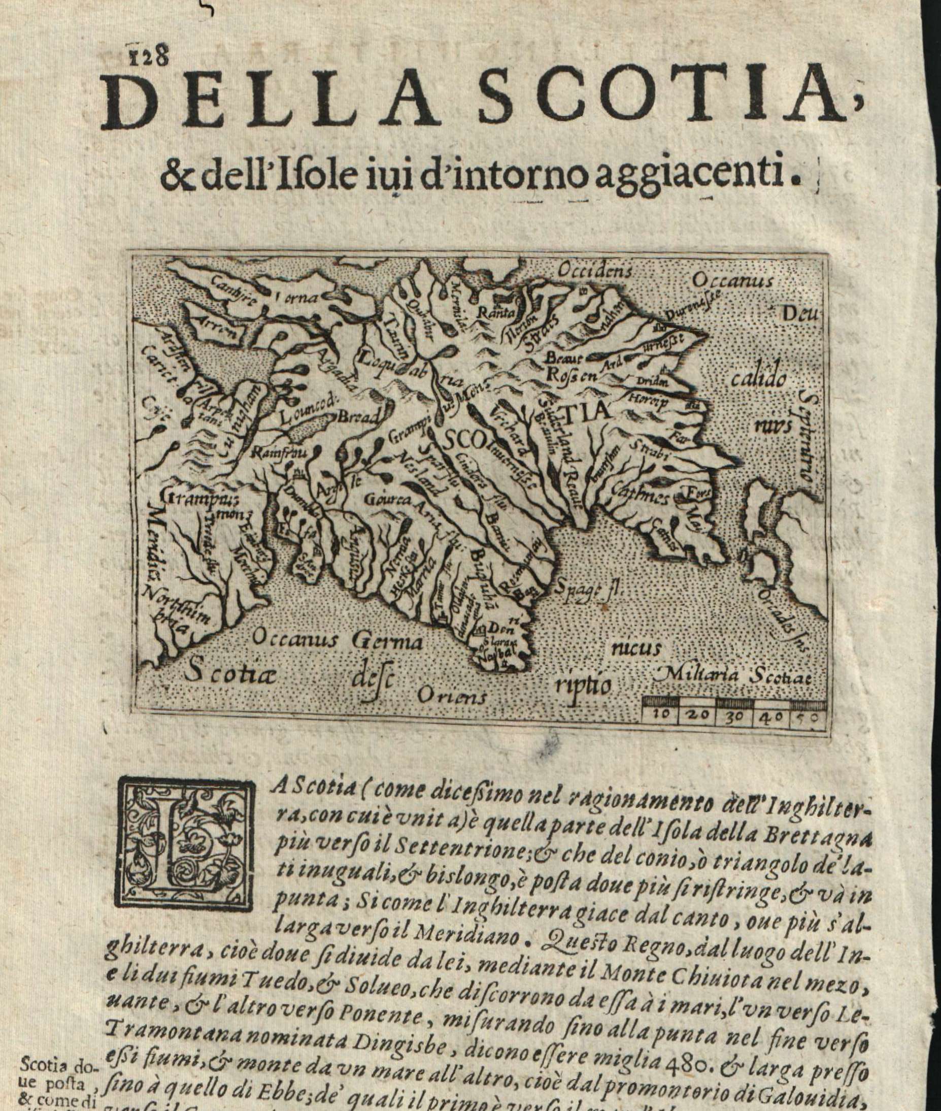
Map title
Scotiae
Author
Doglioni
Location shown in map
Scotland
Edition date
1623
Edition place
Venice
Editor
Giacomo Sarzina
Atlas
Anfiteatro di Europa
Price
Please ask: info@thetreasuremaps.com
State
[mint/EXCELLENT/very good/good/fair/mediocre/poor]
Color
Black/white
Verso
Italian text pag.127
Size
Plate: cm (11.4 x 8.9) inches (4.49 x 3.5) Paper: cm (15.2 x 22.9) inches (5.98 x 9.02)
Technique
Copper engraving
Note
The maps are copies of the Galle (c.1595) edition of Ortelius.
Reference
--
Wiki
Here for more info
In stock
Available
Info
info@thetreasuremaps.com
Code
#0611
×
![Scotiae by Doglioni, Scotland, 1623]()
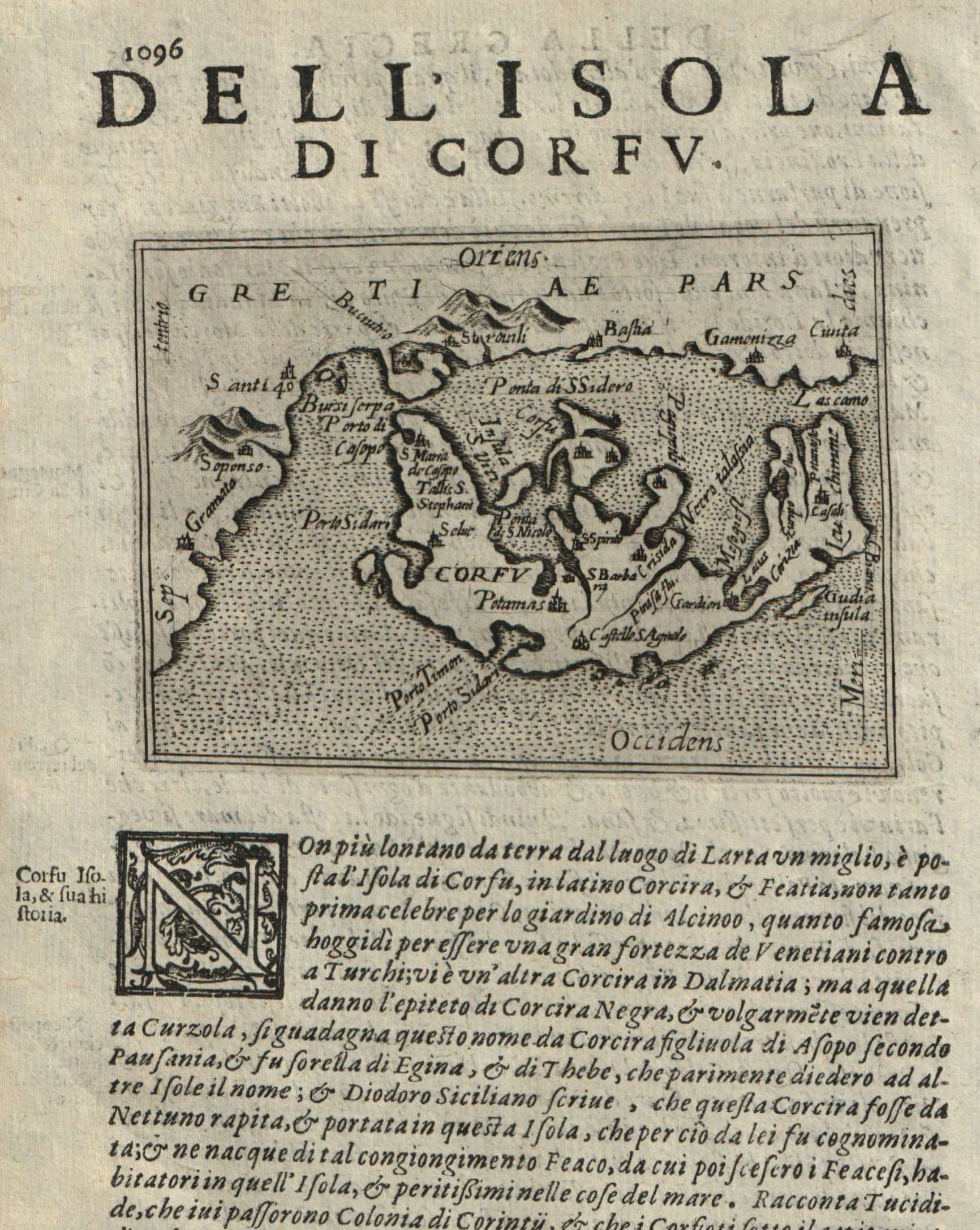
Map title
Corfu
Author
Doglioni
Location shown in map
Corfu
Edition date
1623
Edition place
Venice
Editor
Giacomo Sarzina
Atlas
Anfiteatro di Europa
Price
Please ask: info@thetreasuremaps.com
State
[mint/EXCELLENT/very good/good/fair/mediocre/poor]
Color
Black/white
Verso
Italian text pag.1095
Size
Plate: cm (11.4 x 8.9) inches (4.49 x 3.5) Paper: cm (15.2 x 22.9) inches (5.98 x 9.02)
Technique
Copper engraving
Note
The maps are copies of the Galle (c.1595) edition of Ortelius.
Reference
--
Wiki
Here for more info
In stock
Available
Info
info@thetreasuremaps.com
Code
#0612
Corfu
Author
Doglioni
Location shown in map
Corfu
Edition date
1623
Edition place
Venice
Editor
Giacomo Sarzina
Atlas
Anfiteatro di Europa
Price
Please ask: info@thetreasuremaps.com
State
[mint/EXCELLENT/very good/good/fair/mediocre/poor]
Color
Black/white
Verso
Italian text pag.1095
Size
Plate: cm (11.4 x 8.9) inches (4.49 x 3.5) Paper: cm (15.2 x 22.9) inches (5.98 x 9.02)
Technique
Copper engraving
Note
The maps are copies of the Galle (c.1595) edition of Ortelius.
Reference
--
Wiki
Here for more info
In stock
Available
Info
info@thetreasuremaps.com
Code
#0612
×
![Corfu by Doglioni, Corfu, 1623]()
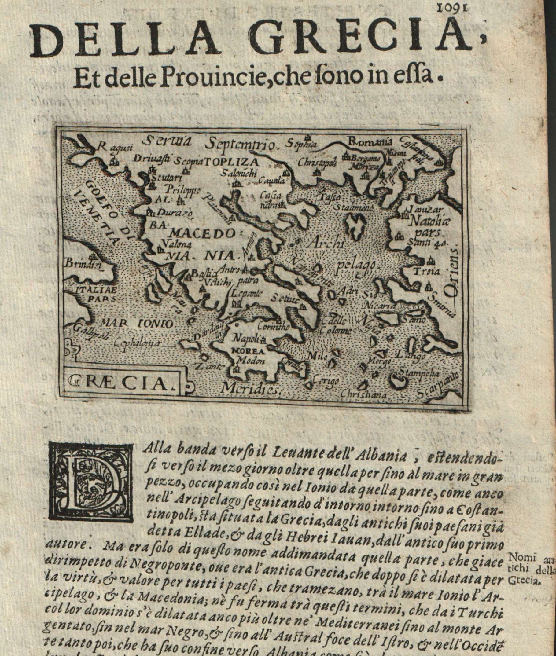
Map title
Graecia
Author
Doglioni
Location shown in map
Greece
Edition date
1623
Edition place
Venice
Editor
Giacomo Sarzina
Atlas
Anfiteatro di Europa
Price
Please ask: info@thetreasuremaps.com
State
[mint/EXCELLENT/very good/good/fair/mediocre/poor]
Color
Black/white
Verso
Italian text pag.1092
Size
Plate: cm (11.4 x 8.9) inches (4.49 x 3.5) Paper: cm (15.2 x 22.9) inches (5.98 x 9.02)
Technique
Copper engraving
Note
The maps are copies of the Galle (c.1595) edition of Ortelius.
Reference
--
Wiki
Here for more info
In stock
Available
Info
info@thetreasuremaps.com
Code
#0613
×
![Graecia by Doglioni, Greece, 1623]()
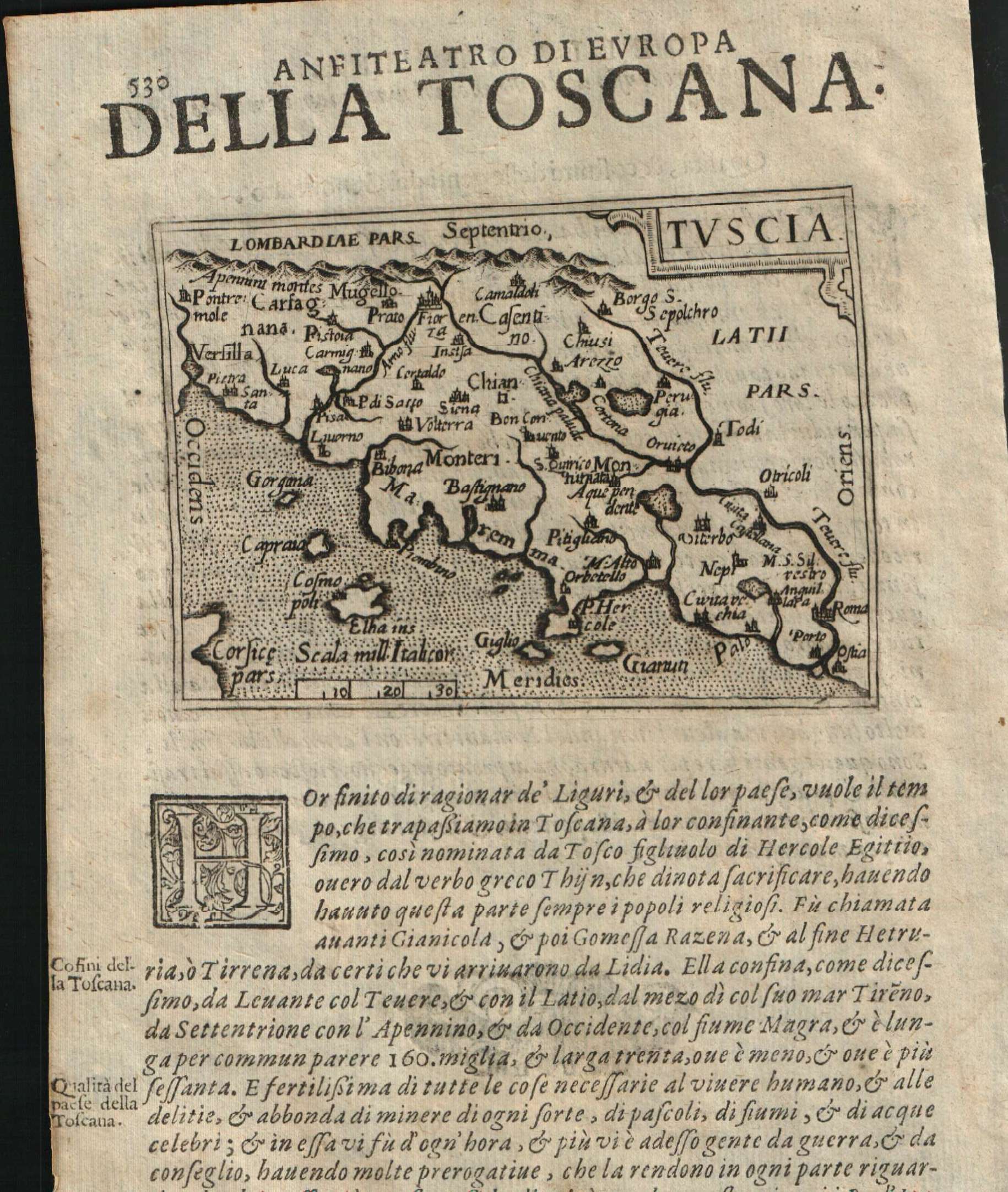
Map title
Tuscia
Author
Doglioni
Location shown in map
Tuscany
Edition date
1623
Edition place
Venice
Editor
Giacomo Sarzina
Atlas
Anfiteatro di Europa
Price
Please ask: info@thetreasuremaps.com
State
[mint/EXCELLENT/very good/good/fair/mediocre/poor]
Color
Black/white
Verso
Italian text pag.529
Size
Plate: cm (11.4 x 8.9) inches (4.49 x 3.5) Paper: cm (15.2 x 22.9) inches (5.98 x 9.02)
Technique
Copper engraving
Note
The maps are copies of the Galle (c.1595) edition of Ortelius.
Reference
--
Wiki
Here for more info
In stock
Available
Info
info@thetreasuremaps.com
Code
#0614
×
![Tuscia by Doglioni, Tuscany, 1623]()
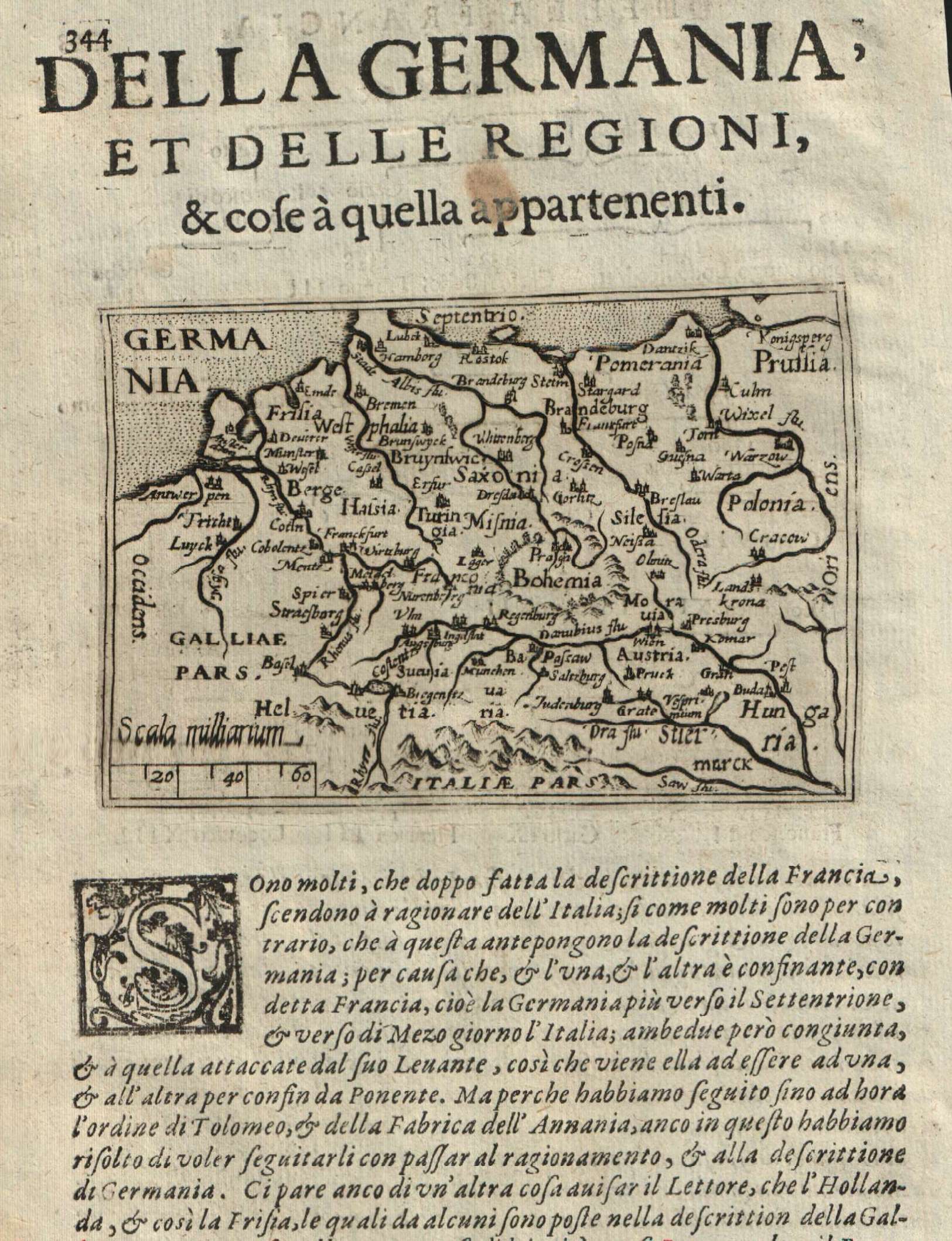
Map title
Germania
Author
Doglioni
Location shown in map
Germany
Edition date
1623
Edition place
Venice
Editor
Giacomo Sarzina
Atlas
Anfiteatro di Europa
Price
Please ask: info@thetreasuremaps.com
State
[mint/EXCELLENT/very good/good/fair/mediocre/poor]
Color
Black/white
Verso
Italian text pag.343
Size
Plate: cm (11.4 x 8.9) inches (4.49 x 3.5) Paper: cm (15.2 x 22.9) inches (5.98 x 9.02)
Technique
Copper engraving
Note
The maps are copies of the Galle (c.1595) edition of Ortelius.
Reference
--
Wiki
Here for more info
In stock
Available
Info
info@thetreasuremaps.com
Code
#0615
×
![Germania by Doglioni, Germany, 1623]()
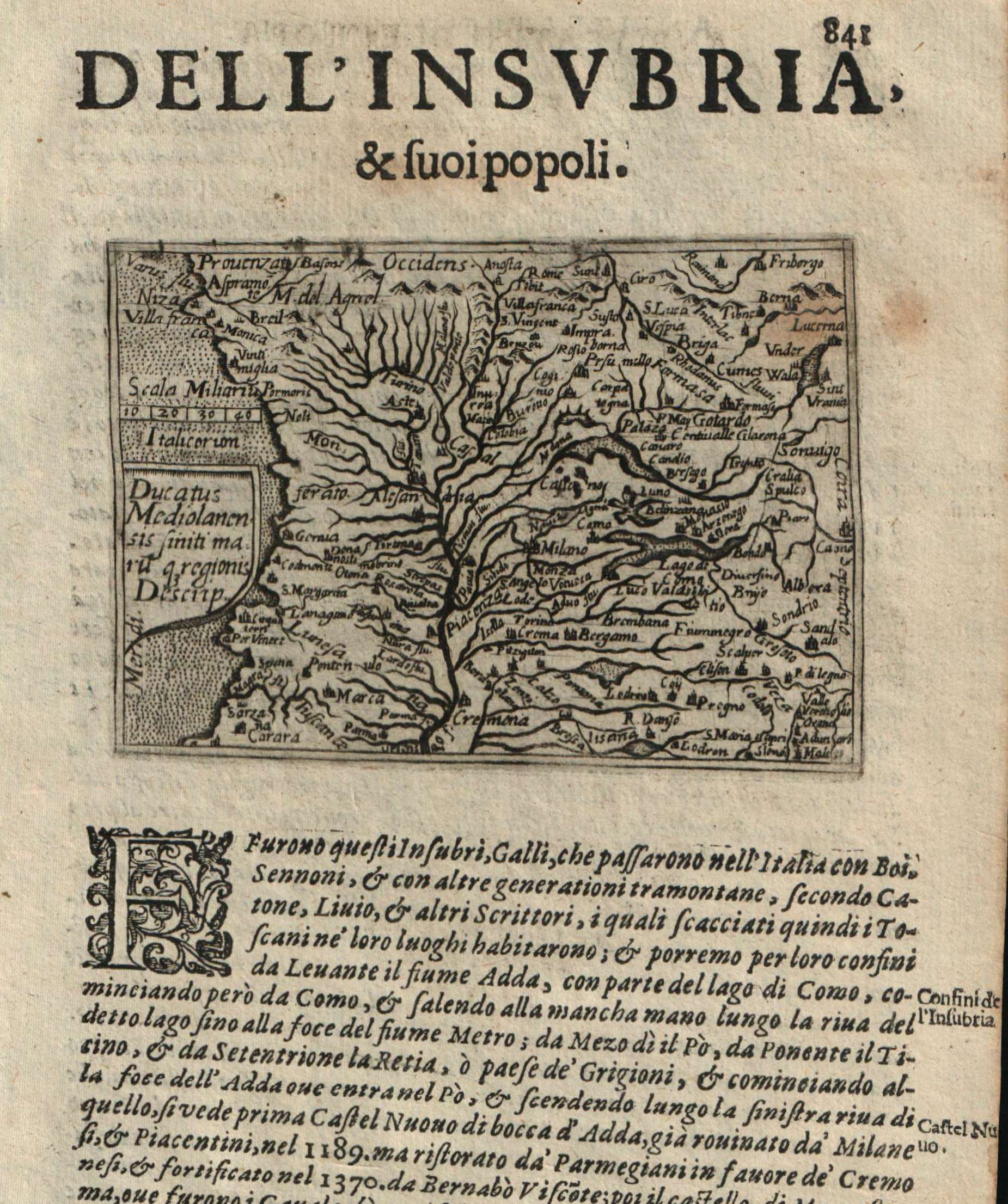
Map title
Ducatus Mediolanensis
Author
Doglioni
Location shown in map
Liguria
Edition date
1623
Edition place
Venice
Editor
Giacomo Sarzina
Atlas
Anfiteatro di Europa
Price
400 Euro
State
[mint/EXCELLENT/very good/good/fair/mediocre/poor]
Color
Black/white
Verso
Italian text pag.842
Size
Plate: cm (11.4 x 8.9) inches (4.49 x 3.5) Paper: cm (15.2 x 22.9) inches (5.98 x 9.02)
Technique
Copper engraving
Note
The maps are copies of the Galle (c.1595) edition of Ortelius.
Reference
--
Wiki
Here for more info
In stock
Available
Info
info@thetreasuremaps.com
Code
#0623
×
![Ducatus Mediolanensis by Doglioni, Liguria, 1623]()
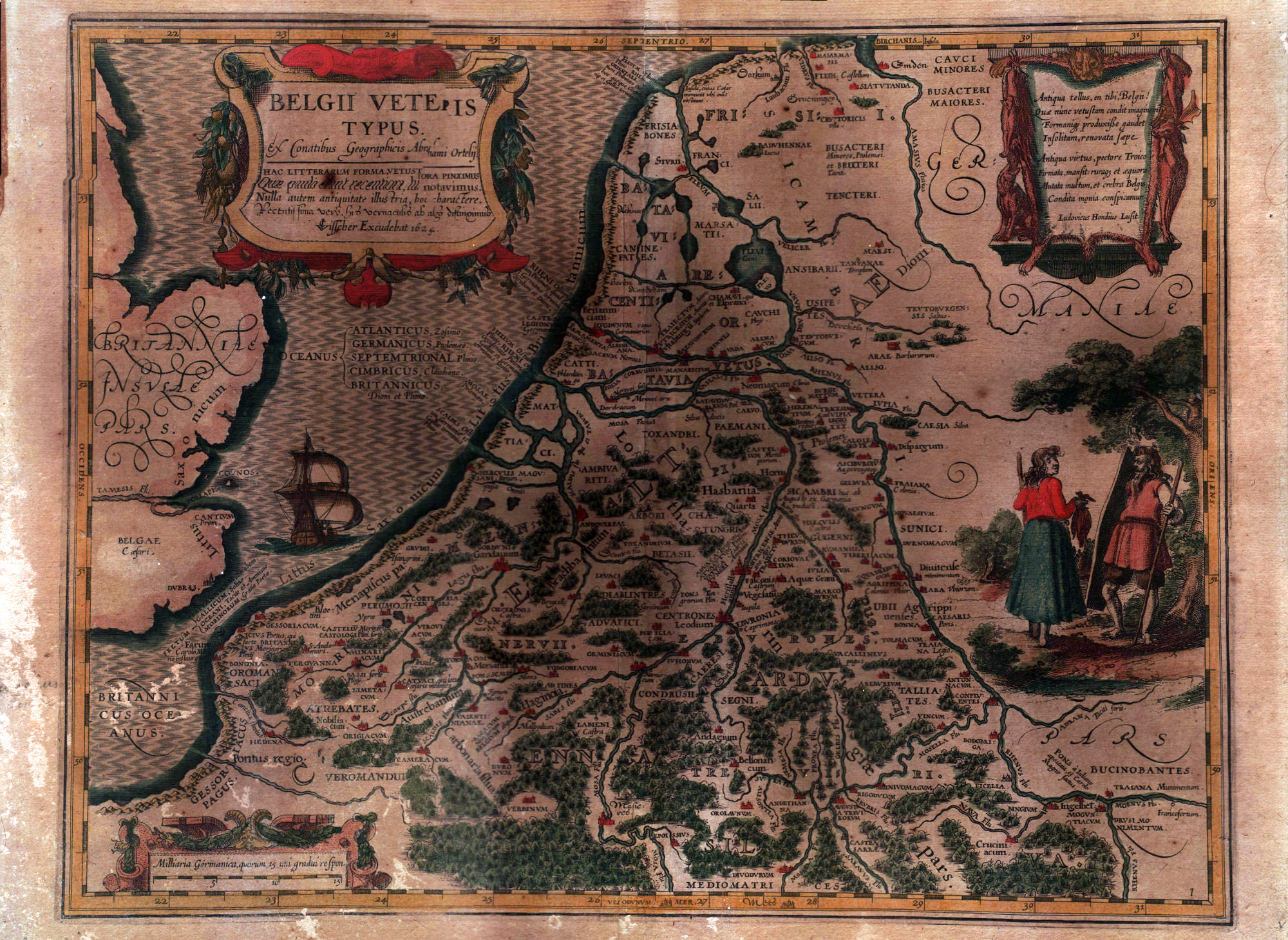
Map title
Belgii veteris typus
Author
Ortelius
Location shown in map
Belgium
Edition date
1624
Edition place
Amsterdam
Editor
--
Atlas
--
Price
Please ask: info@thetreasuremaps.com
State
[mint/excellent/very good/good/FAIR/mediocre/poor]
Color
Old colors
Verso
Blank
Size
Plate: cm (48.3 x 38.1) inches (19.02 x 15) Paper: cm (55.9 x 43.2) inches (22.01 x 17.01)
Technique
Copper engraving
Note
Glued to a cardboard
Reference
--
Wiki
Here for more info
In stock
Available
Info
info@thetreasuremaps.com
Code
#0567
×
![Belgii veteris typus by Ortelius, Belgium, 1624]()
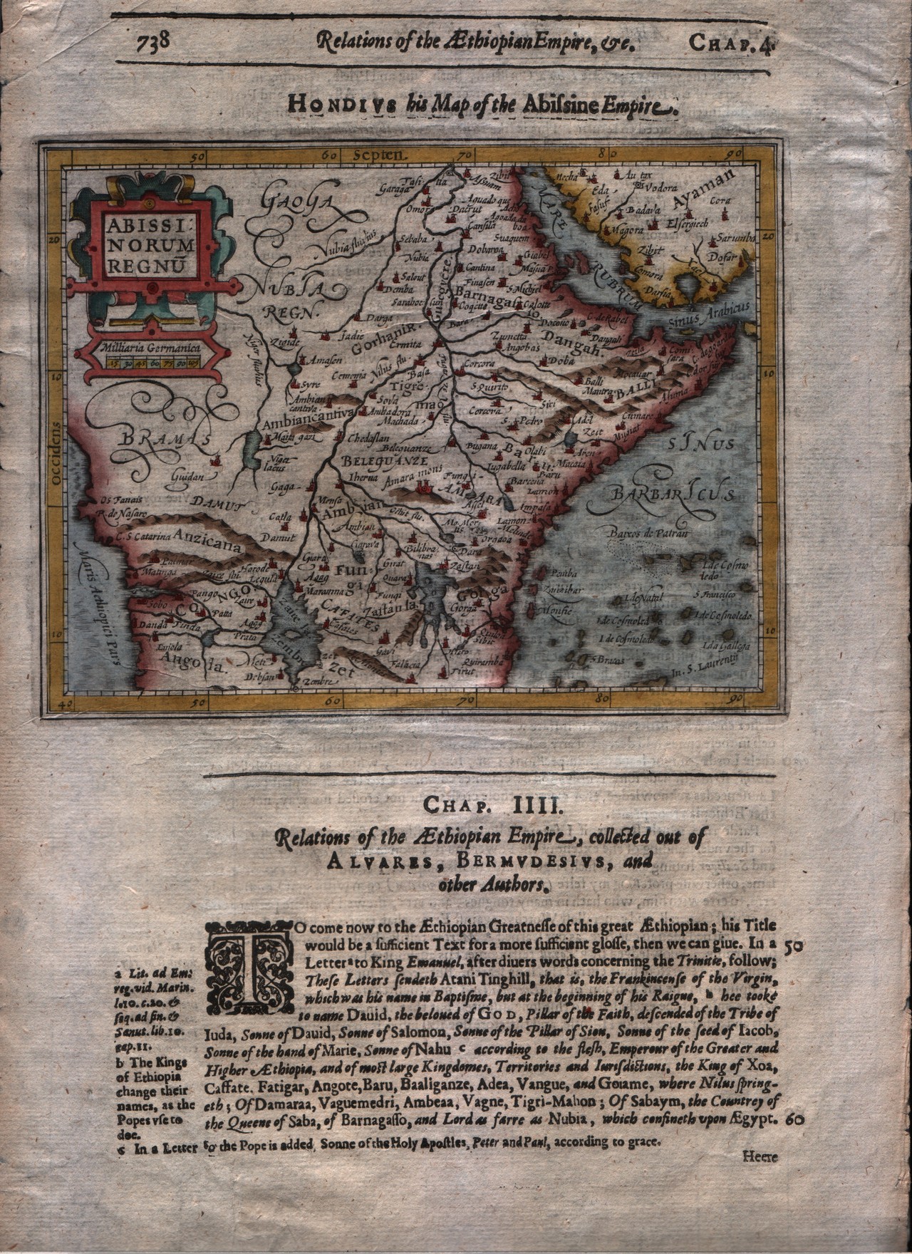
Map title
Abissinorum regnum
Author
Mercator
Location shown in map
East Africa
Edition date
1625
Edition place
London
Editor
--
Atlas
Purchas his Pilgrimes
Price
250 Euro
State
[mint/EXCELLENT/very good/good/fair/mediocre/poor]
Color
Modern colors
Verso
English text
Size
Plate: cm (17.8 x 14) inches (7.01 x 5.51) Paper: cm (21.6 x 33) inches (8.5 x 12.99)
Technique
Copper engraving
Note
No particular notes for this maps
Reference
--
Wiki
Here for more info
In stock
Available
Info
info@thetreasuremaps.com
Code
#0293
×
![Abissinorum regnum by Mercator, East Africa, 1625]()
Map title
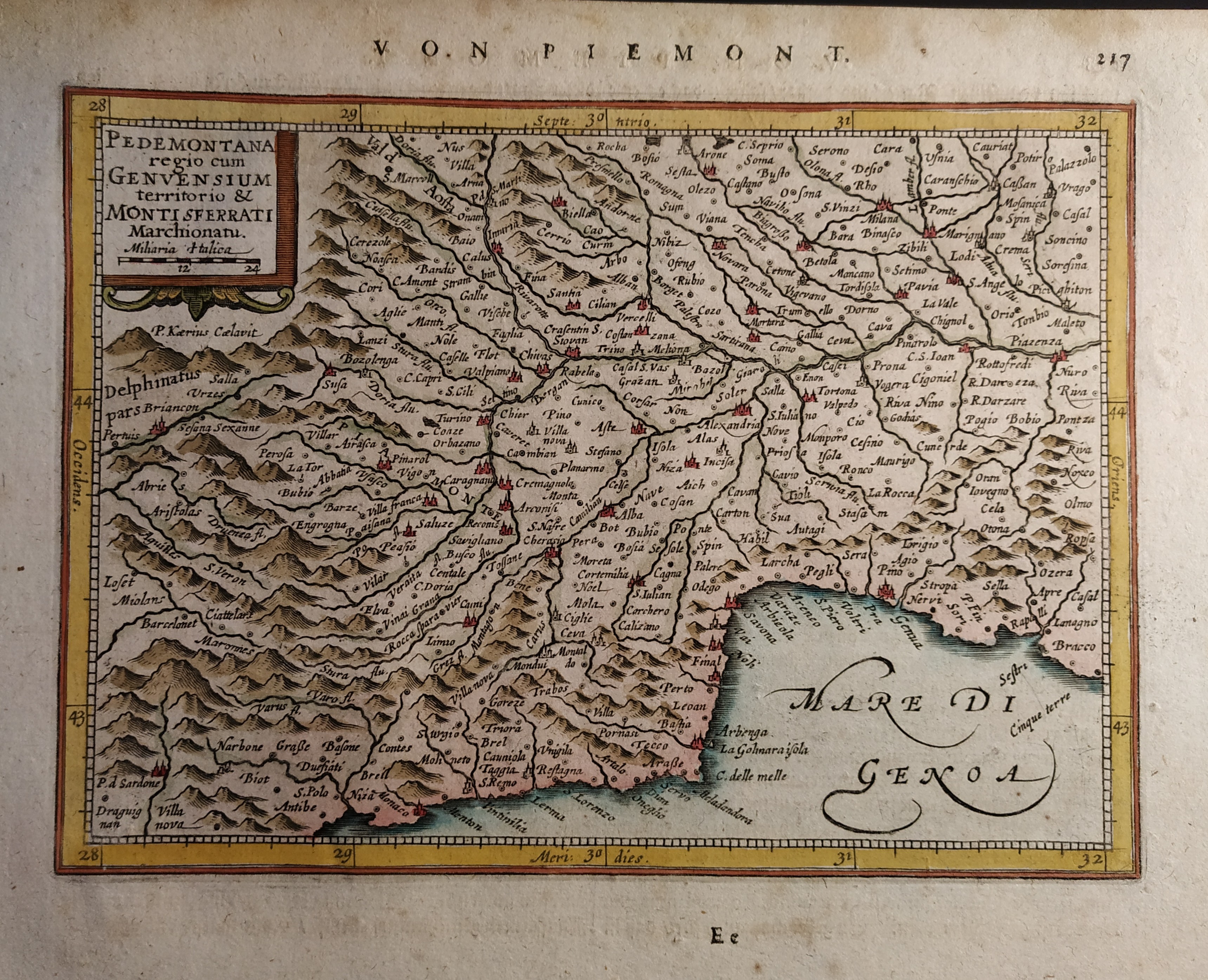
Pedemontana regio cum Genvensium territorio & Montisferrati marchionatu
Author
Mercator
Location shown in map
North-West Italy
Edition date
Circa 1628
Edition place
Amsterdam
Editor
Janssonius
Atlas
Altas Minor Gerardi Mercatoris
Price
150 Euro
State
[mint/EXCELLENT/very good/good/fair/mediocre/poor]
Color
Old colors
Verso
German text pag 218
Size
Plate: cm (19 x 14) inches (7.48 x 5.51) Paper: cm (23 x 19) inches (9.06 x 7.48)
Technique
Copper engraving
Note
No particular notes for this maps.
Reference
Wiki
Here for more info
In stock
Available
Info
info@thetreasuremaps.com
Code
#0660
×
![Pedemontana regio cum Genvensium territorio & Montisferrati marchionatu by Mercator, North-West Italy, Circa 1628]()
Map title
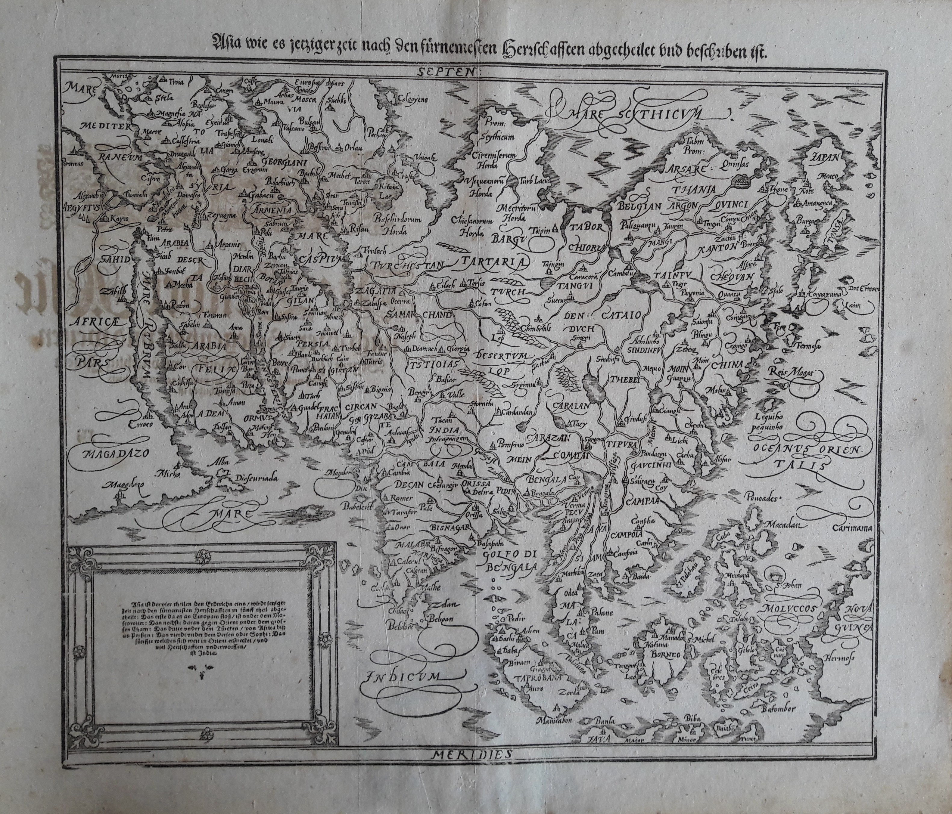
Asia
Author
Munster
Location shown in map
Asia
Edition date
1628
Edition place
Basel
Editor
Henrich Petri
Atlas
Cosmographia Universalis
Price
600 Euro
State
[mint/excellent/VERY GOOD/good/fair/mediocre/poor]
Color
Black/white
Verso
German text
Size
Plate: cm (35.6 x 30.5) inches (14.02 x 12.01) Paper: cm (43.2 x 36.8) inches (17.01 x 14.49)
Technique
Woodcut
Note
--
Reference
--
Wiki
Here for more info
In stock
Available
Info
info@thetreasuremaps.com
Code
#0213
Asia
Author
Munster
Location shown in map
Asia
Edition date
1628
Edition place
Basel
Editor
Henrich Petri
Atlas
Cosmographia Universalis
Price
600 Euro
State
[mint/excellent/VERY GOOD/good/fair/mediocre/poor]
Color
Black/white
Verso
German text
Size
Plate: cm (35.6 x 30.5) inches (14.02 x 12.01) Paper: cm (43.2 x 36.8) inches (17.01 x 14.49)
Technique
Woodcut
Note
--
Reference
--
Wiki
Here for more info
In stock
Available
Info
info@thetreasuremaps.com
Code
#0213
×
![Asia by Munster, Asia, 1628]()
Map title
Nova Virginiae tabula
Author
Pieter van den Keere
Location shown in map
Virginiae
Edition date
1628
Edition place
Amsterdam
Editor
Janssonius
Atlas
Altas Minor Gerardi Mercatoris
Price
400 Euro
State
[mint/EXCELLENT/very good/good/fair/mediocre/poor]
Color
Black/white
Verso
French text pag.632
Size
Plate: cm (19 x 13) inches (7.48 x 5.12) Paper: cm (22 x 17) inches (8.66 x 6.69)
Technique
Copper engraving
Note
No particular notes for this maps.
Reference
--
Wiki
Here for more info
In stock
Available
Info
info@thetreasuremaps.com
Code
#0655
×
![Nova Virginiae tabula by Pieter van den Keere, Virginiae, 1628]()
Map title
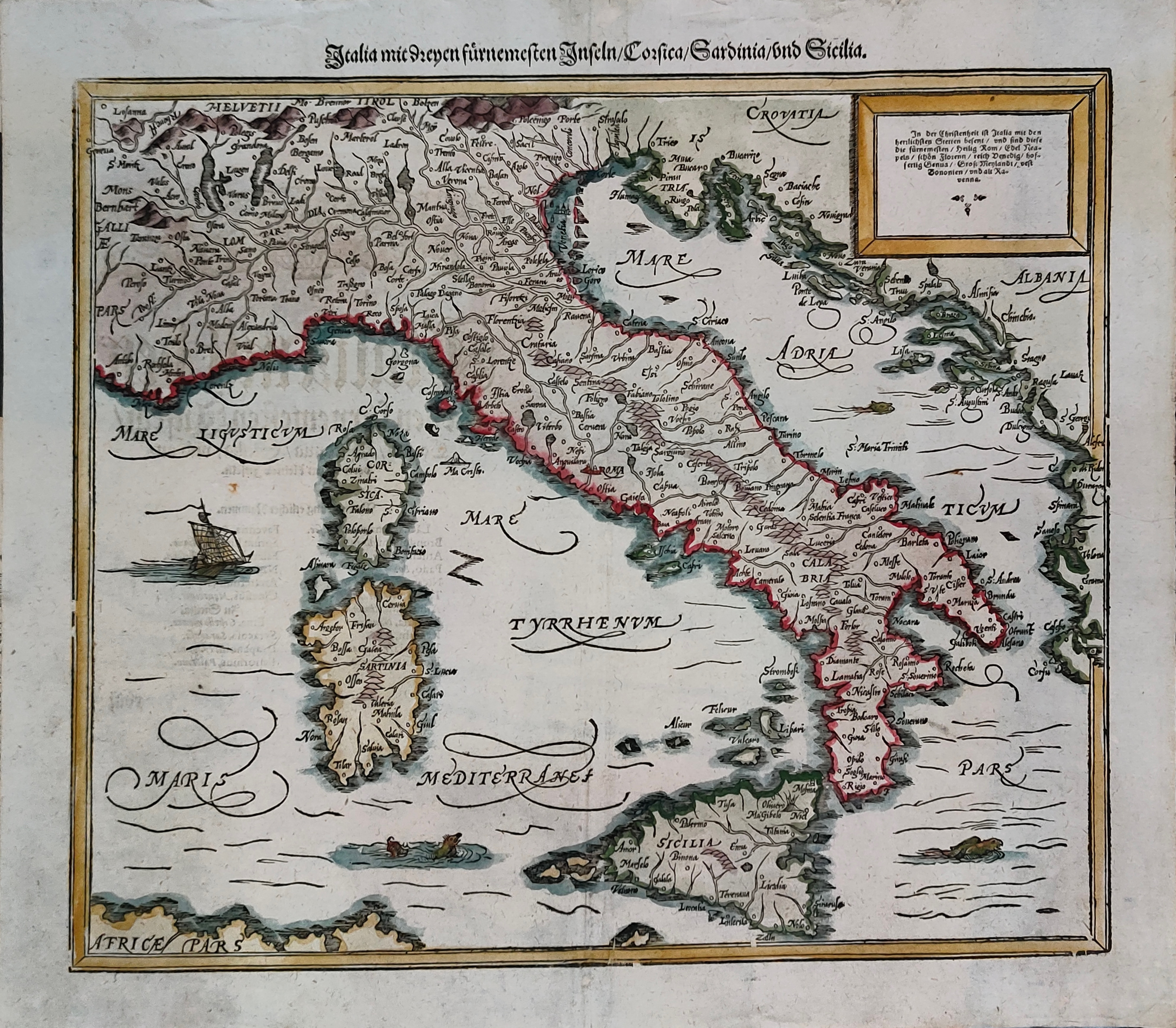
Italia mit Dreyen Furnemesten Inseln
Author
Munster
Location shown in map
Italy
Edition date
Circa 1628
Edition place
Basel
Editor
Henrich Petri
Atlas
Cosmographia Universalis
Price
450 Euro
State
[mint/EXCELLENT/very good/good/fair/mediocre/poor]
Color
Old colors
Verso
German text
Size
Plate: cm (37 x 30) inches (14.57 x 11.81) Paper: cm (41 x 36) inches (16.14 x 14.17)
Technique
Woodcut
Note
Reference
R.Borri L'Italia nelle antiche carte pag.50
Wiki
Here for more info
In stock
Available
Info
info@thetreasuremaps.com
Code
#1301
×
![Italia mit Dreyen Furnemesten Inseln by Munster, Italy, Circa 1628]()
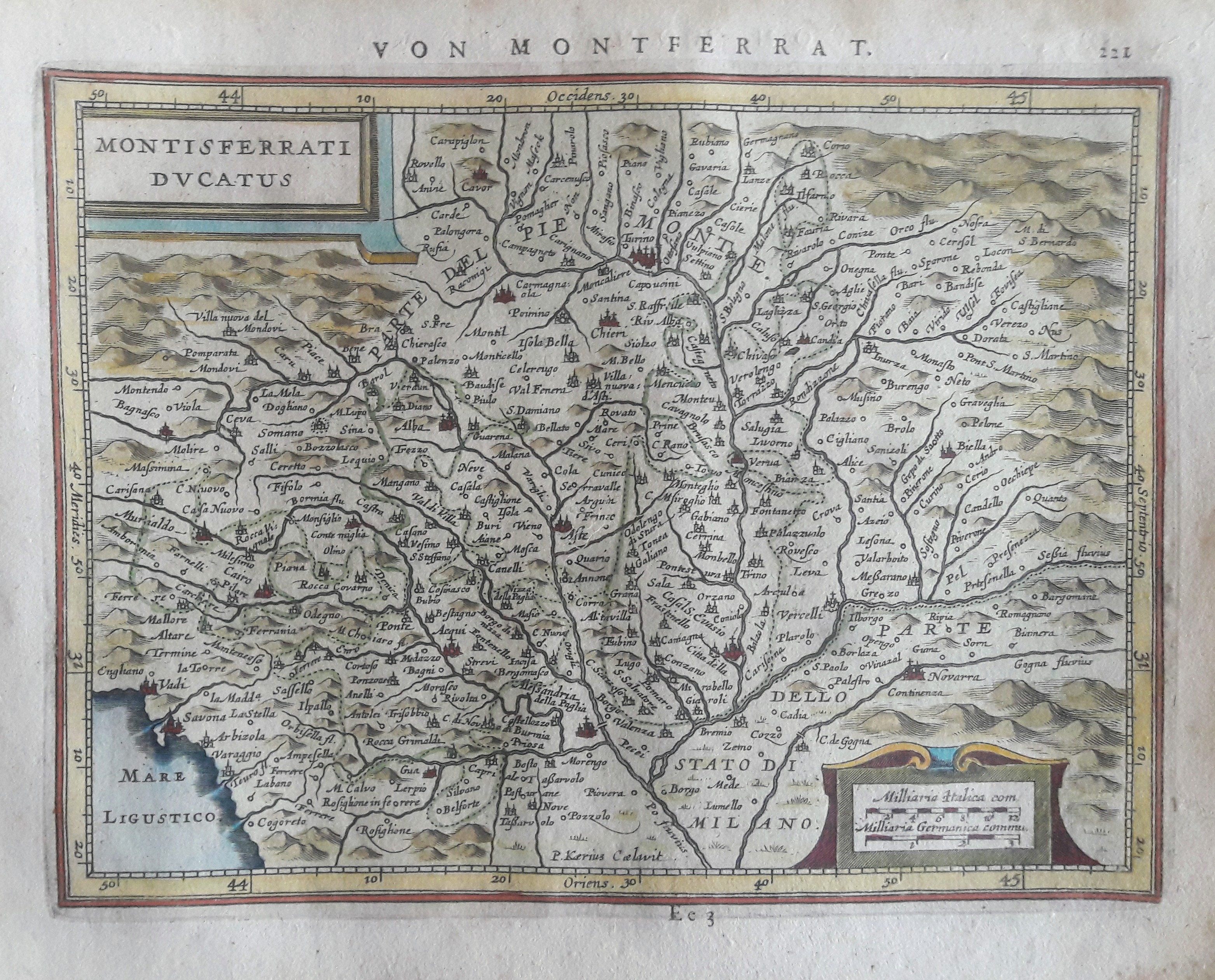
Map title
Montisferrati Ducatus
Author
Mercator
Location shown in map
North-West Italy
Edition date
Circa 1628
Edition place
Amsterdam
Editor
Janssonius
Atlas
Altas Minor Gerardi Mercatoris
Price
150 Euro
State
[mint/EXCELLENT/very good/good/fair/mediocre/poor]
Color
Old colors
Verso
German text 222
Size
Plate: cm (20 x 15) inches (7.87 x 5.91) Paper: cm (23 x 19) inches (9.06 x 7.48)
Technique
Copper engraving
Note
No particular notes for this maps.
Reference
Wiki
Here for more info
In stock
Available
Info
info@thetreasuremaps.com
Code
#0661
×
![Montisferrati Ducatus by Mercator, North-West Italy, Circa 1628]()
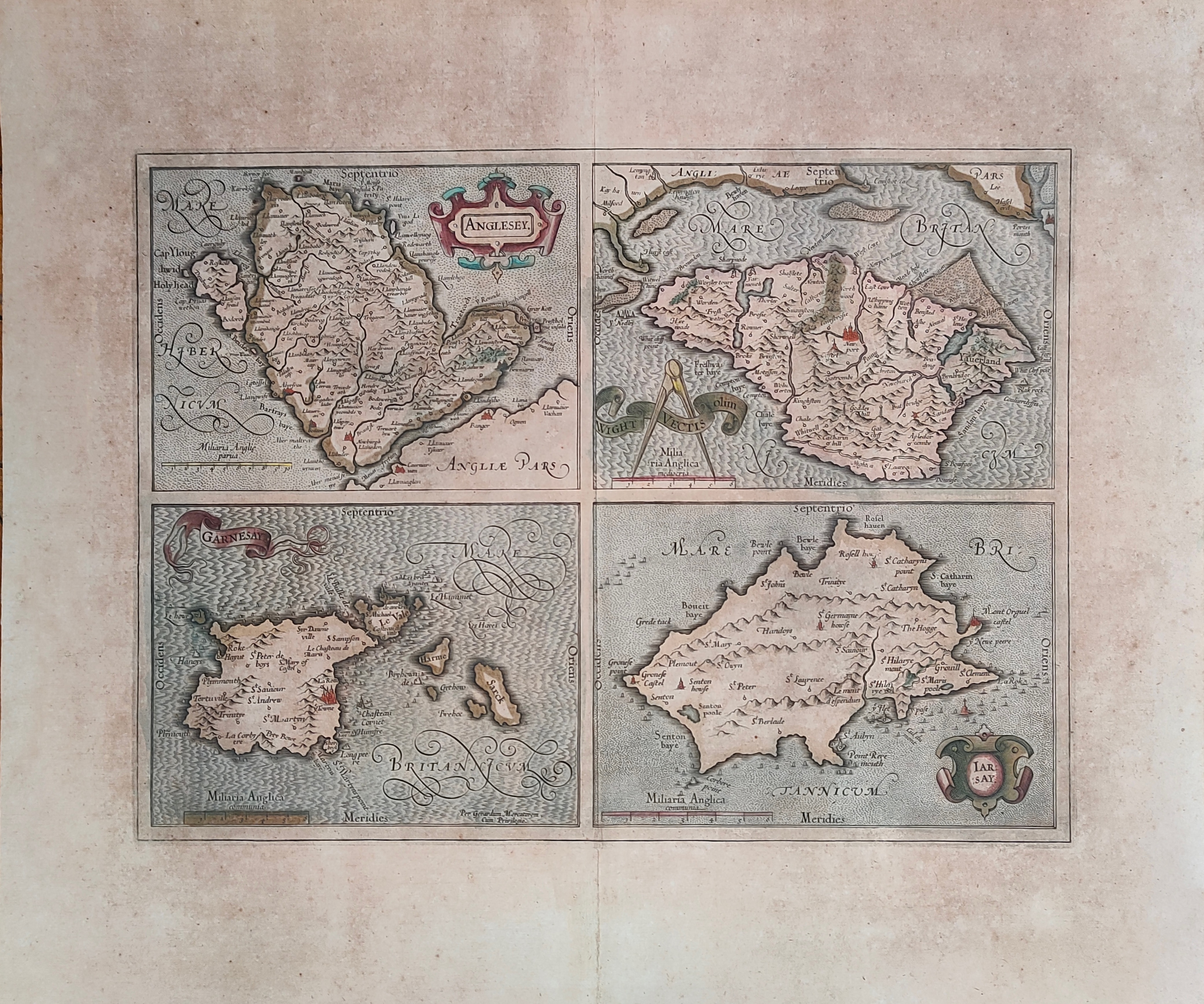
Map title
Anglesey, Garnesay, Wight olim Vectis, Iarsay
Author
Mercator
Location shown in map
Wight
Edition date
Circa 1628
Edition place
Amsterdam
Editor
Houndius
Atlas
Mercator-Hondius Atlas.
Price
250 Euro
State
[mint/EXCELLENT/very good/good/fair/mediocre/poor]
Color
Old colors
Verso
Latin text
Size
Plate: cm (42 x 32) inches (16.54 x 12.6) Paper: cm (55 x 47) inches (21.65 x 18.5)
Technique
Copper engraving
Note
Professionally repaired
Reference
Wiki
Here for more info
In stock
Available
Info
info@thetreasuremaps.com
Code
#1232
×
![Anglesey, Garnesay, Wight olim Vectis, Iarsay by Mercator, Wight, Circa 1628]()
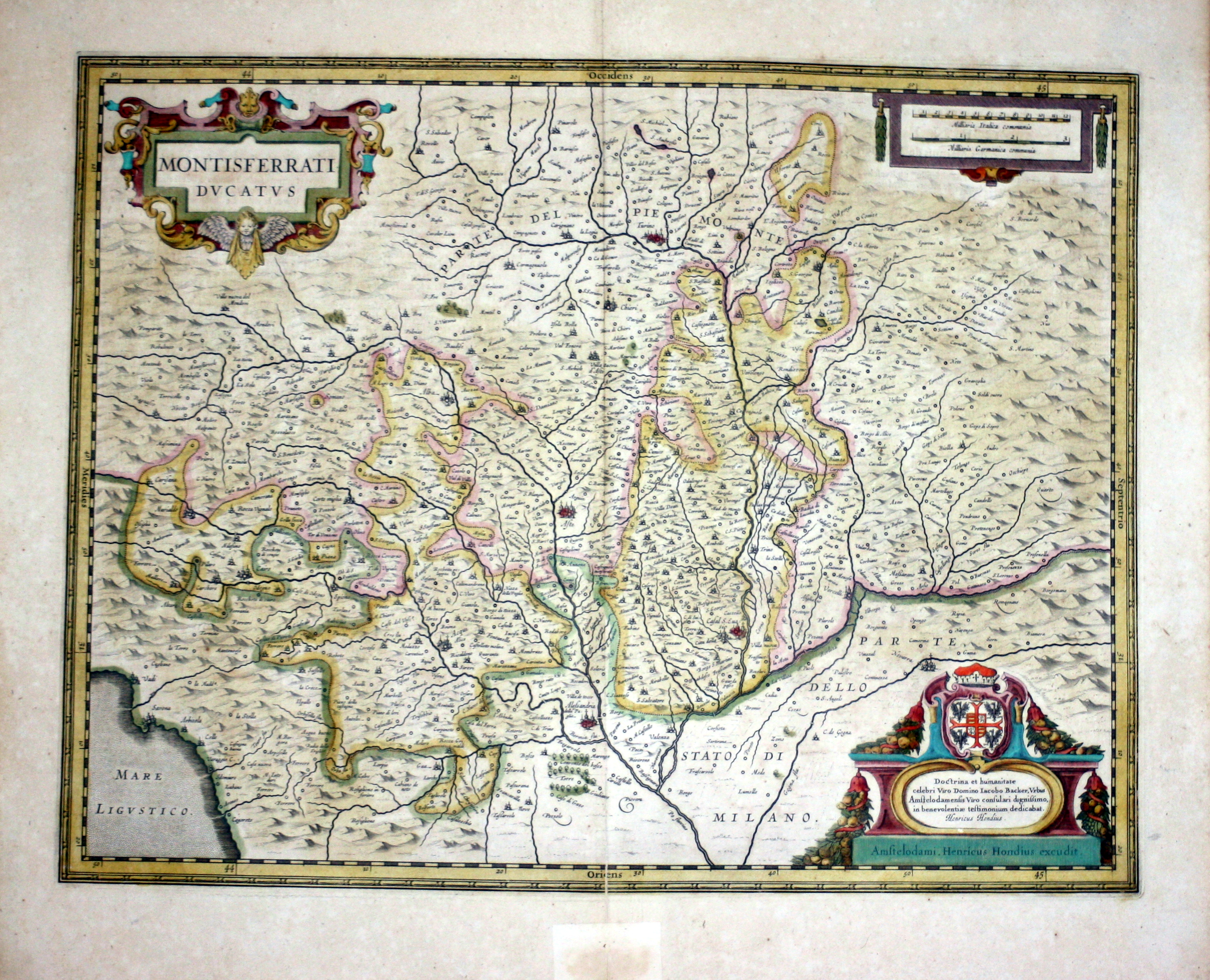
Map title
Montisferrati Ducatus
Author
Hondius
Location shown in map
Piedmont & Liguria, North west Italy
Edition date
1630
Edition place
Amsterdam
Editor
--
Atlas
Atlas Novus
Price
300 Euro
State
[mint/EXCELLENT/very good/good/fair/mediocre/poor]
Color
Old color
Verso
French text
Size
Plate: cm (48.3 x 36.8) inches (19.02 x 14.49) Paper: cm (54.6 x 47) inches (21.5 x 18.5)
Technique
Copper engraving
Note
No particular notes for this maps
Reference
--
Wiki
Here for more info
In stock
Available
Info
info@thetreasuremaps.com
Code
#0096
×
![Montisferrati Ducatus by Hondius, Piedmont & Liguria, North west Italy, 1630]()
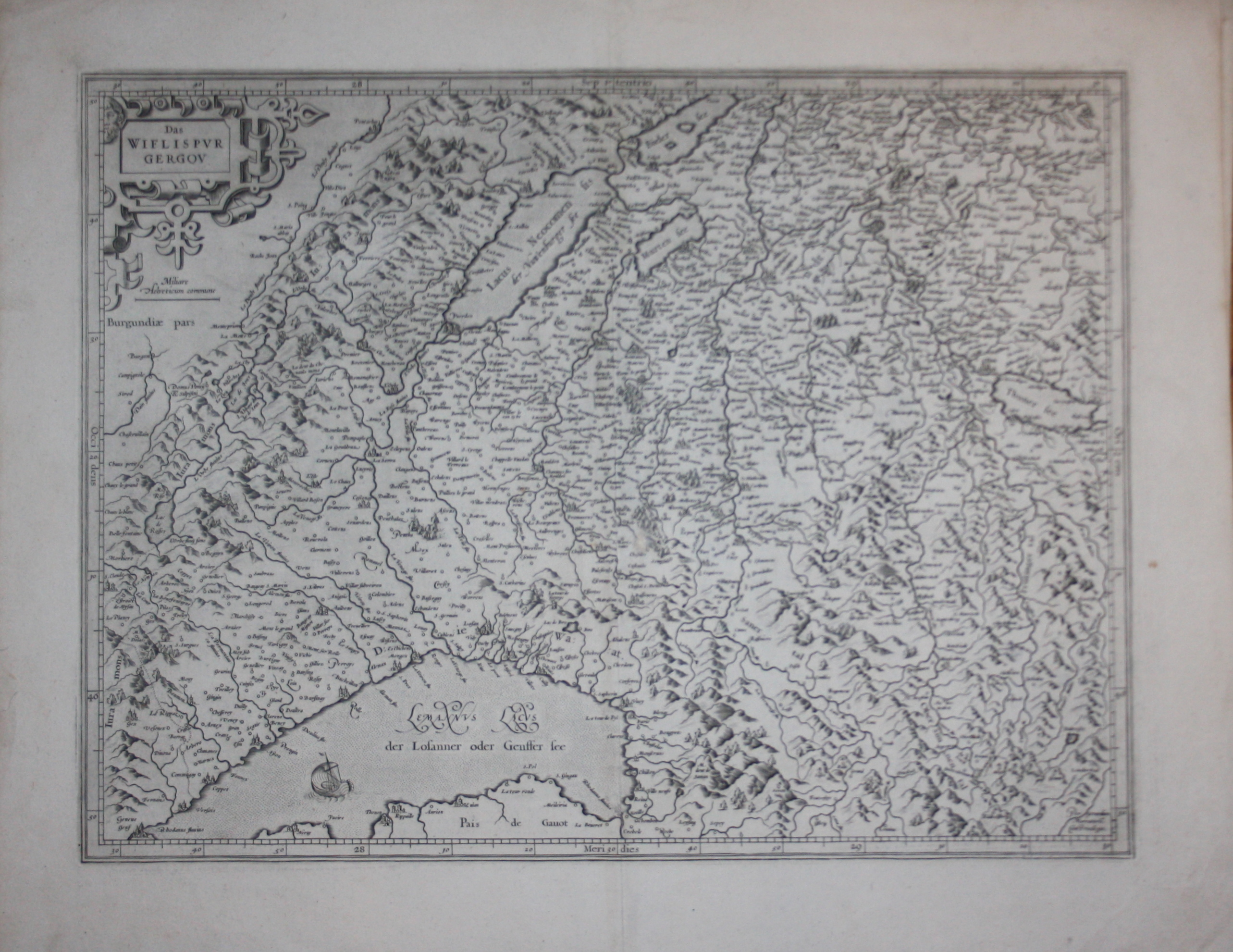
Map title
Das Wiflispvrgergow
Author
Mercator
Location shown in map
Switzerland
Edition date
Circa 1630
Edition place
--
Editor
--
Atlas
--
Price
200 Euro
State
[mint/excellent/VERY GOOD/good/fair/mediocre/poor]
Color
Black/white
Verso
Latin text pag.184
Size
Plate: cm (47 x 35.6) inches (18.5 x 14.02) Paper: cm (57.2 x 43.2) inches (22.52 x 17.01)
Technique
Copper engraving
Note
Reference
--
Wiki
Here for more info
In stock
Available
Info
info@thetreasuremaps.com
Code
#0503
×
![Das Wiflispvrgergow by Mercator, Switzerland, Circa 1630]()