1600-1699
Map title
Scotiae pars septentrionalis
Author
Hondius
Location shown in map
Scotland
Edition date
1638
Edition place
Amsterdam
Editor
Atlas
Price
400 Euro
State
[mint/EXCELLENT/very good/good/fair/mediocre/poor]
Color
Old colors
Verso
Latin text
Size
Plate: cm (45 x 35) inches (17.72 x 13.78) Paper: cm (55 x 46) inches (21.65 x 18.11)
Technique
Copper engraving
Note
Reference
Wiki
Here for more info
In stock
Available
Info
info@thetreasuremaps.com
Code
#1073
×
![Scotiae pars septentrionalis by Hondius, Scotland, 1638]()
Map title
Italia
Author
Bertelli
Location shown in map
Italy
Edition date
1638
Edition place
Vicenza
Editor
Bolzetta
Atlas
Itineriarium nobiliorum Italiae
Price
250 Euro
State
[mint/excellent/very good/GOOD/fair/mediocre/poor]
Color
Black/white
Verso
Blank
Size
Plate: cm (18 x 13) inches (7.09 x 5.12) Paper: cm (19 x 15) inches (7.48 x 5.91)
Technique
Copper engraving
Note
Reference
R.Borri L'Italia nelle antiche carte pag.108
Wiki
Here for more info
In stock
Available
Info
info@thetreasuremaps.com
Code
#1168
×
![Italia by Bertelli, Italy, 1638]()
Map title
Reipublicae Genuensis Ducatus Et Dominii.
Author
Jansson
Location shown in map
Liguria
Edition date
Circa 1638
Edition place
Amsterdam
Editor
Hondius
Atlas
Atlas sive Cosmographicae meditationes de fabrica mvndi et fabricati figvra
Price
600 Euro
State
[mint/EXCELLENT/very good/good/fair/mediocre/poor]
Color
Old colors
Verso
German text
Size
Plate: cm (49 x 38) inches (19.29 x 14.96) Paper: cm (58 x 51) inches (22.83 x 20.08)
Technique
Copper engraving
Note
Reference
Wiki
Here for more info
In stock
Available
Info
info@thetreasuremaps.com
Code
#1257
×
![Reipublicae Genuensis Ducatus Et Dominii. by Jansson, Liguria, Circa 1638]()
Map title
Pianta di Cremona e delle altre fortezze de Milano
Author
Homann
Location shown in map
Chateau de Seravalle
Edition date
Unknown
Edition place
--
Editor
--
Atlas
--
Price
Please ask: info@thetreasuremaps.com
State
[mint/excellent/very good/good/fair/mediocre/POOR] Only a small part of the map.
Color
Old outlined
Verso
Blank
Size
Plate: cm (14 x 12.7) inches (5.51 x 5) Paper: cm (16.5 x 15.2) inches (6.5 x 5.98)
Technique
Copper engraving
Note
No particular notes for this maps
Reference
--
Wiki
Here for more info
In stock
Available
Info
info@thetreasuremaps.com
Code
#0141
×
![Pianta di Cremona e delle altre fortezze de Milano by Homann, Chateau de Seravalle, Unknown]()
Map title
Carte generale des royaume d'Angleterre
Author
Sanson
Location shown in map
British Isles
Edition date
1640
Edition place
Paris
Editor
Melchior Tavenier
Atlas
Price
Please ask: info@thetreasuremaps.com
State
[mint/EXCELLENT/very good/good/fair/mediocre/poor]
Color
Old colors
Verso
Blank
Size
Plate: cm (52 x 39) inches (20.47 x 15.35) Paper: cm (57 x 44) inches (22.44 x 17.32)
Technique
Copper engraving
Note
No particular notes for this maps
Reference
Wiki
Here for more info
In stock
Available
Info
info@thetreasuremaps.com
Code
#0658
×
![Carte generale des royaume d'Angleterre by Sanson, British Isles, 1640]()
Map title
Nova Italiae delineatio
Author
Merian
Location shown in map
Italy
Edition date
Circa 1640
Edition place
Frankfurt
Editor
Atlas
Price
300 Euro
State
[mint/EXCELLENT/very good/good/fair/mediocre/poor]
Color
Black/white
Verso
Blank
Size
Plate: cm (36 x 28) inches (14.17 x 11.02) Paper: cm (37 x 34) inches (14.57 x 13.39)
Technique
Copper engraving
Note
Reference
R.Borri L'Italia nelle antiche carte pag.133
Wiki
Here for more info
In stock
Available
Info
info@thetreasuremaps.com
Code
#1068
×
![Nova Italiae delineatio by Merian, Italy, Circa 1640]()
Map title
Cyprus insula
Author
Blaeu
Location shown in map
Cyprus
Edition date
Circa 1640
Edition place
Amsterdam
Editor
Blaeu
Atlas
Theatrum Orbis Terrarum, Sive Atlas Novis
Price
1100 Euro
State
[mint/EXCELLENT/very good/good/fair/mediocre/poor]
Color
Old colors
Verso
Dutch text
Size
Plate: cm (50 x 38) inches (19.69 x 14.96) Paper: cm (56 x 44) inches (22.05 x 17.32)
Technique
Copper engraving
Note
Reference
--
Wiki
Here for more info
In stock
Available
Info
info@thetreasuremaps.com
Code
#1071
×
![Cyprus insula by Blaeu, Cyprus, Circa 1640]()
Map title
Peru
Author
Blaeu
Location shown in map
Peru
Edition date
Circa 1640
Edition place
Amsterdam
Editor
Blaeu
Atlas
Theatrum Orbis Terrarum, Sive Atlas Novis
Price
400 Euro
State
[mint/excellent/very good/GOOD/fair/mediocre/poor]
Color
Old colors
Verso
French text
Size
Plate: cm (50 x 38) inches (19.69 x 14.96) Paper: cm (60 x 48) inches (23.62 x 18.9)
Technique
Copper engraving
Note
Professionally restored
Reference
--
Wiki
Here for more info
In stock
Available
Info
info@thetreasuremaps.com
Code
#1075
Peru
Author
Blaeu
Location shown in map
Peru
Edition date
Circa 1640
Edition place
Amsterdam
Editor
Blaeu
Atlas
Theatrum Orbis Terrarum, Sive Atlas Novis
Price
400 Euro
State
[mint/excellent/very good/GOOD/fair/mediocre/poor]
Color
Old colors
Verso
French text
Size
Plate: cm (50 x 38) inches (19.69 x 14.96) Paper: cm (60 x 48) inches (23.62 x 18.9)
Technique
Copper engraving
Note
Professionally restored
Reference
--
Wiki
Here for more info
In stock
Available
Info
info@thetreasuremaps.com
Code
#1075
×
![Peru by Blaeu, Peru, Circa 1640]()
Map title
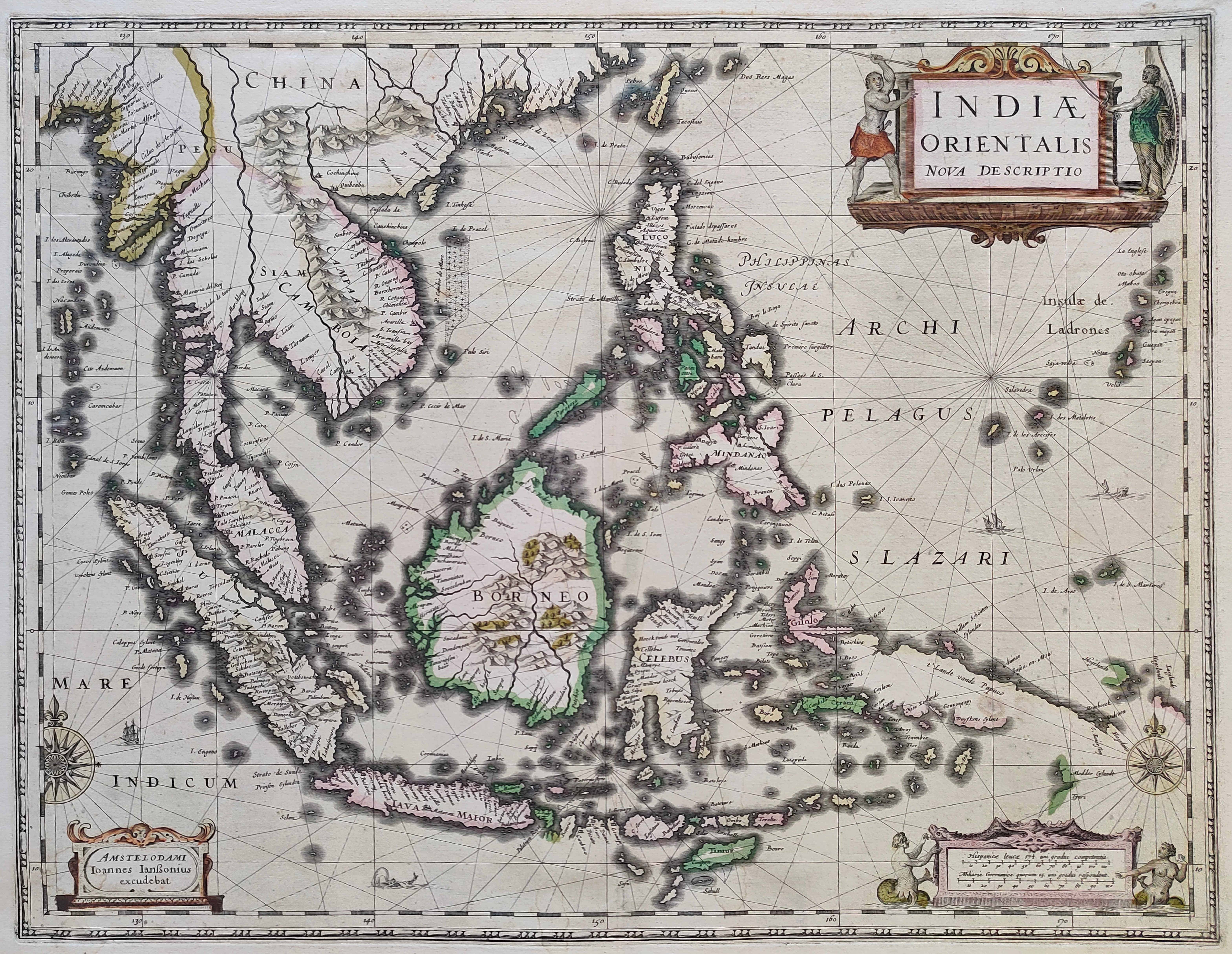
Indiae Orientalis Nova Descriptio
Author
Jansson
Location shown in map
Southest Asia
Edition date
Circa 1640
Edition place
Amsterdam
Editor
--
Atlas
Novus Atlas
Price
1300 Euro
State
[mint/EXCELLENT/very good/good/fair/mediocre/poor]
Color
Old colors
Verso
Franch text pag. 676
Size
Plate: cm (51 x 39) inches (20.08 x 15.35) Paper: cm (58 x 45) inches (22.83 x 17.72)
Technique
Copper engraving
Note
Reference
--
Wiki
Here for more info
In stock
Sold
Info
info@thetreasuremaps.com
Code
#1211
×
![Indiae Orientalis Nova Descriptio by Jansson, Southest Asia, Circa 1640]()
Map title
Liguria
Author
Blaeu
Location shown in map
Liguria
Edition date
Circa 1640
Edition place
Amsterdam
Editor
Atlas
Price
600 Euro
State
[mint/EXCELLENT/very good/good/fair/mediocre/poor]
Color
Old colors
Verso
Size
Plate: cm (51 x 38) inches (20.08 x 14.96) Paper: cm (58 x 50) inches (22.83 x 19.69)
Technique
Copper engraving
Note
Reference
Wiki
Here for more info
In stock
Available
Info
info@thetreasuremaps.com
Code
#1224
Liguria
Author
Blaeu
Location shown in map
Liguria
Edition date
Circa 1640
Edition place
Amsterdam
Editor
Atlas
Price
600 Euro
State
[mint/EXCELLENT/very good/good/fair/mediocre/poor]
Color
Old colors
Verso
Size
Plate: cm (51 x 38) inches (20.08 x 14.96) Paper: cm (58 x 50) inches (22.83 x 19.69)
Technique
Copper engraving
Note
Reference
Wiki
Here for more info
In stock
Available
Info
info@thetreasuremaps.com
Code
#1224
×
![Liguria by Blaeu, Liguria, Circa 1640]()
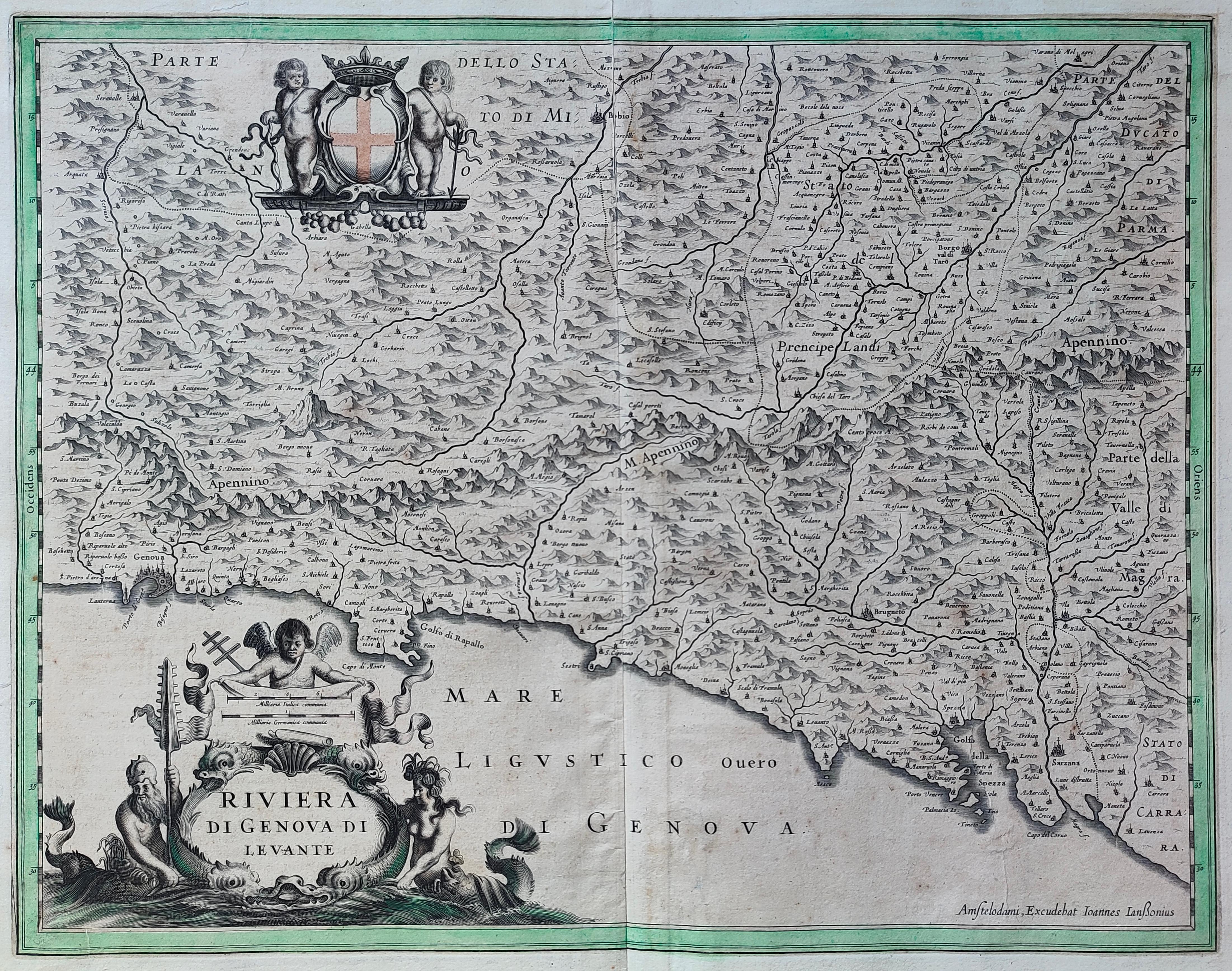
Map title
Riviera di Genova di Levante
Author
Jansson
Location shown in map
Liguria
Edition date
Circa 1640
Edition place
Editor
Atlas
Price
500 Euro
State
[mint/excellent/VERY GOOD/good/fair/mediocre/poor]
Color
Old colors
Verso
German text
Size
Plate: cm (50 x 39) inches (19.69 x 15.35) Paper: cm (55 x 44) inches (21.65 x 17.32)
Technique
Copper engraving
Note
Reference
Wiki
Here for more info
In stock
Available
Info
info@thetreasuremaps.com
Code
#1283
×
![Riviera di Genova di Levante by Jansson, Liguria, Circa 1640]()
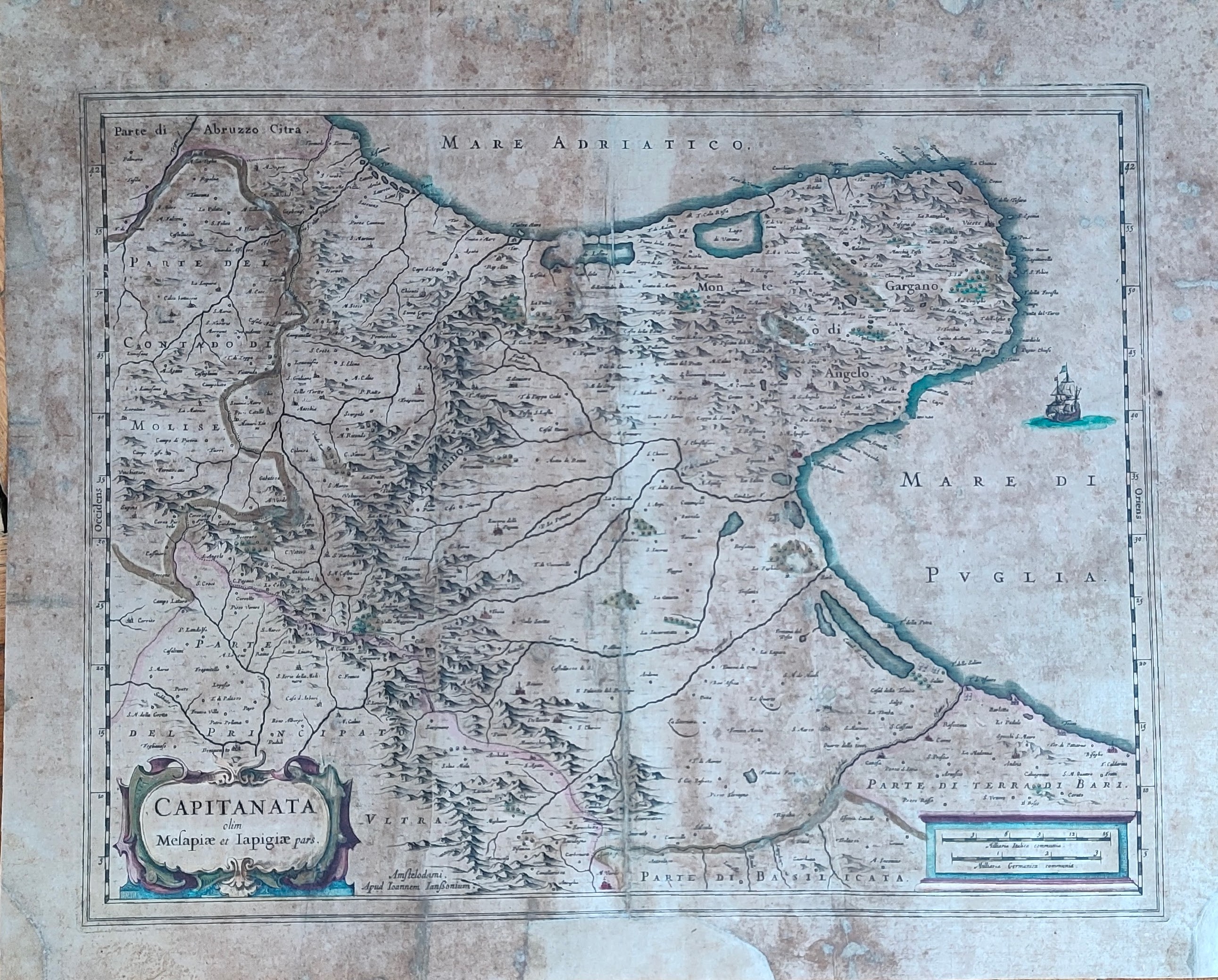
Map title
Capitanata olim Mesapiae et Iapigiae pars
Author
Jansson
Location shown in map
Puglia
Edition date
Circa 1640
Edition place
Amsterdam
Editor
Atlas
Atlas Novus
Price
200 Euro
State
[mint/excellent/very good/good/fair/mediocre/POOR]
Color
Old colors
Verso
Latin text
Size
Plate: cm (49 x 37) inches (19.29 x 14.57) Paper: cm (55 x 44) inches (21.65 x 17.32)
Technique
Copper engraving
Note
Reference
Wiki
Here for more info
In stock
Available
Info
info@thetreasuremaps.com
Code
#1294
×
![Capitanata olim Mesapiae et Iapigiae pars by Jansson, Puglia, Circa 1640]()

Map title
Sclavonia, Croatia, Bosnia cum Dalmatiae Parte
Author
Mercator
Location shown in map
Balkan
Edition date
Circa 1640
Edition place
Amsterdam
Editor
Hondius
Atlas
Mercator-Hondius Atlas.
Price
200 Euro
State
[mint/excellent/VERY GOOD/good/fair/mediocre/poor]
Color
Old colors
Verso
Latin text
Size
Plate: cm (46 x 36) inches (18.11 x 14.17) Paper: cm (55 x 46) inches (21.65 x 18.11)
Technique
Copper engraving
Note
Reference
Wiki
Here for more info
In stock
Available
Info
info@thetreasuremaps.com
Code
#1297
×
![Sclavonia, Croatia, Bosnia cum Dalmatiae Parte by Mercator, Balkan, Circa 1640]()
Map title
Natolia quae olim Asia Minor
Author
Blaeu
Location shown in map
Turkey
Edition date
Circa 1640
Edition place
Amsterdam
Editor
Atlas
Theatrum Orbis Terrarum, Sive Atlas Novis
Price
300 Euro
State
[mint/EXCELLENT/very good/good/fair/mediocre/poor]
Color
Old colors
Verso
Blank
Size
Plate: cm (50 x 38) inches (19.69 x 14.96) Paper: cm (55 x 45) inches (21.65 x 17.72)
Technique
Copper engraving
Note
Reference
Wiki
Here for more info
In stock
Available
Info
info@thetreasuremaps.com
Code
#1382
×
![Natolia quae olim Asia Minor by Blaeu, Turkey, Circa 1640]()
Map title
Guiana Sive Amazonum Regio
Author
Blaeu
Location shown in map
Guiana
Edition date
Circa 1641
Edition place
Amsterdam
Editor
Blaeu
Atlas
Price
400 Euro
State
[mint/EXCELLENT/very good/good/fair/mediocre/poor]
Color
Old colors
Verso
Latin text
Size
Plate: cm (48 x 37) inches (18.9 x 14.57) Paper: cm (59 x 48) inches (23.23 x 18.9)
Technique
Copper engraving
Note
No particular notes for this maps
Reference
Wiki
Here for more info
In stock
Available
Info
info@thetreasuremaps.com
Code
#0731
×
![Guiana Sive Amazonum Regio by Blaeu, Guiana, Circa 1641]()
Map title
Carte de l'Italie
Author
Tavernier
Location shown in map
Italy
Edition date
Circa 1642
Edition place
Paris
Editor
Atlas
Price
800 Euro
State
[mint/EXCELLENT/very good/good/fair/mediocre/poor]
Color
Old colors
Verso
Blank
Size
Plate: cm (60 x 52) inches (23.62 x 20.47) Paper: cm (51 x 70) inches (20.08 x 27.56)
Technique
Copper engraving
Note
framed
Reference
R.Borri L'Italia nelle antiche carte pag.136
Wiki
Here for more info
In stock
Available
Info
info@thetreasuremaps.com
Code
#1226
×
![Carte de l'Italie by Tavernier, Italy, Circa 1642]()

Map title
Descriptio Fluminum Rheni, Vahalis et Mosae a Rheno Berca ad Goricomium usque
Author
Hondius
Location shown in map
Rhine
Edition date
Circa 1642
Edition place
Amsterdam
Editor
Hondius
Atlas
Price
175 Euro
State
[mint/EXCELLENT/very good/good/fair/mediocre/poor]
Color
Old colors
Verso
Latin text
Size
Plate: cm (49 x 37) inches (19.29 x 14.57) Paper: cm (56 x 48) inches (22.05 x 18.9)
Technique
Copper engraving
Note
Professionally repaired
Reference
Wiki
Here for more info
In stock
Available
Info
info@thetreasuremaps.com
Code
#1233
×
![Descriptio Fluminum Rheni, Vahalis et Mosae a Rheno Berca ad Goricomium usque by Hondius, Rhine, Circa 1642]()
Map title
Genua
Author
Lauro
Location shown in map
Genoa
Edition date
1642
Edition place
Rome
Editor
Lauro
Atlas
Heroico Splendore delle Città del Mondo
Price
1000 Euro
State
[mint/EXCELLENT/very good/good/fair/mediocre/poor]
Color
Black/white
Verso
Blank
Size
Plate: cm (24 x 18) inches (9.45 x 7.09) Paper: cm (30 x 23) inches (11.81 x 9.06)
Technique
Copper engraving
Note
Reference
Wiki
Here for more info
In stock
Available
Info
info@thetreasuremaps.com
Code
#1345
×
![Genua by Lauro, Genoa, 1642]()
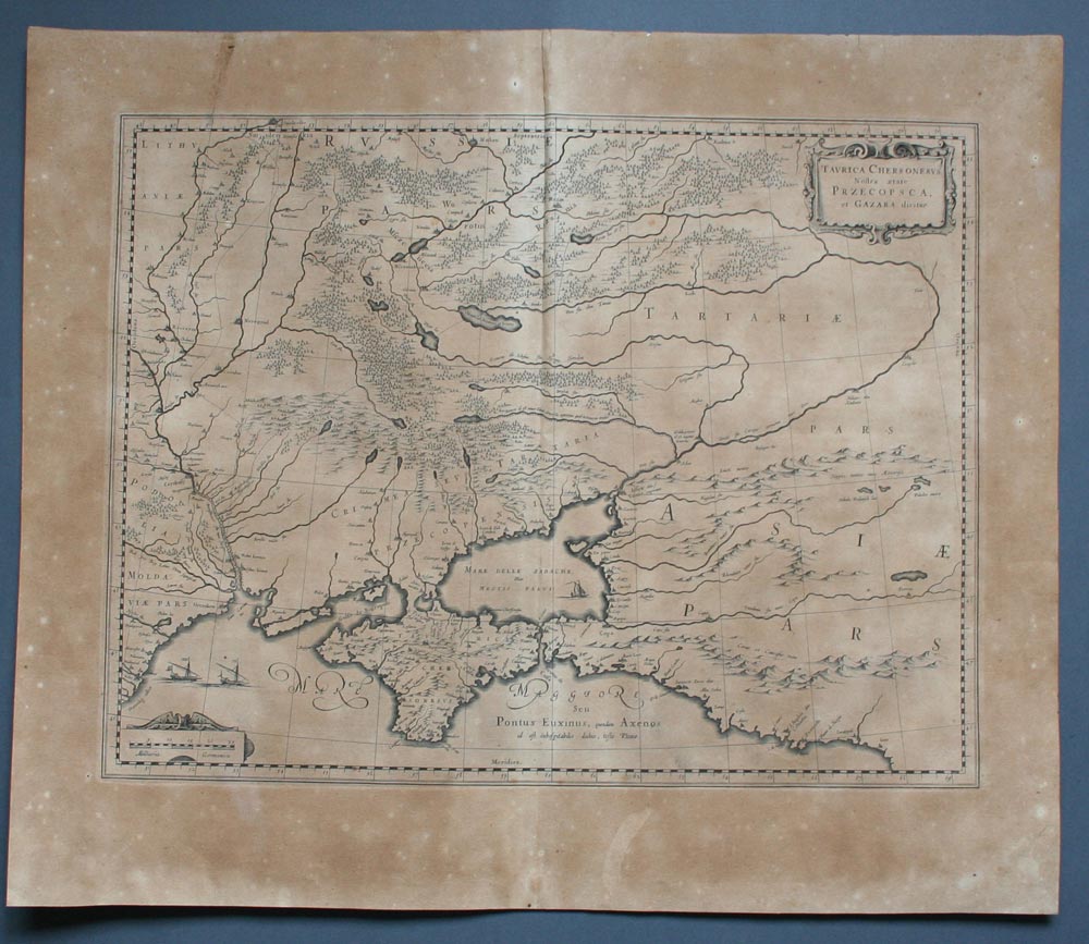
Map title
Taurica Chersonesus. Nostra aetate Przecopsca, et Gazara dicitur.
Author
Blaeu
Location shown in map
Russia and Black sea
Edition date
1645
Edition place
Amsterdam
Editor
--
Atlas
Theatrum Orbis Terrarum, Sive Atlas Novis
Price
200 Euro
State
[mint/excellent/VERY GOOD/good/fair/mediocre/poor]
Color
Black/white
Verso
Latin text
Size
Plate: cm (48.3 x 35.6) inches (19.02 x 14.02) Paper: cm (58.4 x 50.8) inches (22.99 x 20)
Technique
Copper engraving
Note
No particular notes for this maps
Reference
--
Wiki
Here for more info
In stock
Available
Info
info@thetreasuremaps.com
Code
#0217
×
![Taurica Chersonesus. Nostra aetate Przecopsca, et Gazara dicitur. by Blaeu, Russia and Black sea, 1645]()
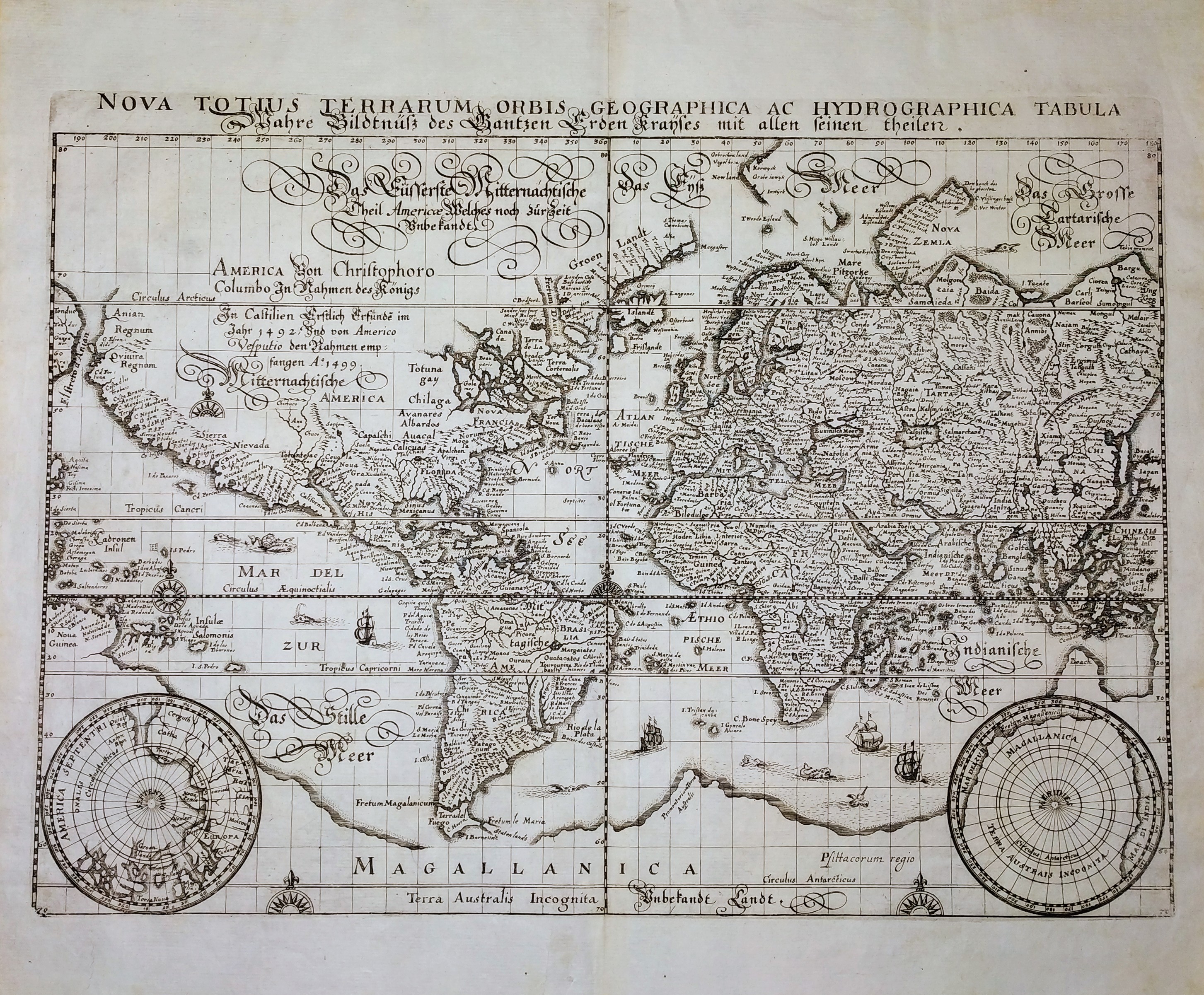
Map title
Nova Totius Terrarum Orbis Geographica ac Hydrographica Tabula
Author
Merian
Location shown in map
World
Edition date
Circa 1646
Edition place
Frankfurt
Editor
--
Atlas
Neuwe Archontologia Cosmica
Price
1000 Euro
State
[MINT/excellent/very good/good/fair/mediocre/poor]
Color
Black/white
Verso
Blank
Size
Plate: cm (35 x 26) inches (13.78 x 10.24) Paper: cm (39 x 33) inches (15.35 x 12.99)
Technique
Copper engraving
Note
No particular notes for this maps.
Reference
--
Wiki
Here for more info
In stock
Available
Info
info@thetreasuremaps.com
Code
#0705
×
![Nova Totius Terrarum Orbis Geographica ac Hydrographica Tabula by Merian, World, Circa 1646]()