1600-1699
Map title
Regni Daniae
Author
Jansson
Location shown in map
Denmark
Edition date
Circa 1647
Edition place
Amsterdam
Editor
Atlas
Price
400 Euro
State
[mint/EXCELLENT/very good/good/fair/mediocre/poor]
Color
Old colors
Verso
Latin text
Size
Plate: cm (56 x 45) inches (22.05 x 17.72) Paper: cm (58 x 49) inches (22.83 x 19.29)
Technique
Copper engraving
Note
Reference
Wiki
Here for more info
In stock
Available
Info
info@thetreasuremaps.com
Code
#1311
×
![Regni Daniae by Jansson, Denmark, Circa 1647]()
Map title
America Meridionalis
Author
Mercator
Location shown in map
South America
Edition date
Circa 1648
Edition place
Amsterdam
Editor
Janssonius
Atlas
Altas Minor Gerardi Mercatoris
Price
Please ask: info@thetreasuremaps.com
State
[mint/EXCELLENT/very good/good/fair/mediocre/poor]
Color
Old colors
Verso
German text pag 402
Size
Plate: cm (19 x 14) inches (7.48 x 5.51) Paper: cm (23 x 18) inches (9.06 x 7.09)
Technique
Copper engraving
Note
No particular notes for this maps
Reference
Wiki
Here for more info
In stock
Available
Info
info@thetreasuremaps.com
Code
#0726
×
![America Meridionalis by Mercator, South America, Circa 1648]()
Map title
Orbis Terrarum Veteribus Cogniti Typus Geographicus
Author
Jansson
Location shown in map
World
Edition date
Circa 1650
Edition place
Amsterdam
Editor
Janssonius
Atlas
Atlas
Price
600 Euro
State
[mint/EXCELLENT/verygood/good/fair/mediocre/poor]
Color
Old colors
Verso
Latin
Size
Plate: cm (49.5 x 39.4) inches (19.49 x 15.51) Paper: cm (58.4 x 48.3) inches (22.99 x 19.02)
Technique
Copper engraving
Note
--
Reference
--
Wiki
Here for more info
In stock
Available
Info
info@thetreasuremaps.com
Code
#0599
×
![Orbis Terrarum Veteribus Cogniti Typus Geographicus by Jansson, World, Circa 1650]()
Map title
Piemonte et Monferrato
Author
Blaeu
Location shown in map
North-West Italy
Edition date
Circa 1650
Edition place
Amsterdam
Editor
Blaeu
Atlas
Atlas Maior
Price
300 Euro
State
[mint/EXCELLENT/very good/good/fair/mediocre/poor]
Color
Old colors
Verso
Blank
Size
Plate: cm (51 x 41) inches (20.08 x 16.14) Paper: cm (55 x 44) inches (21.65 x 17.32)
Technique
Copper engraving
Note
No particular notes for this maps
Reference
Wiki
Here for more info
In stock
Available
Info
info@thetreasuremaps.com
Code
#0728
×
![Piemonte et Monferrato by Blaeu, North-West Italy, Circa 1650]()
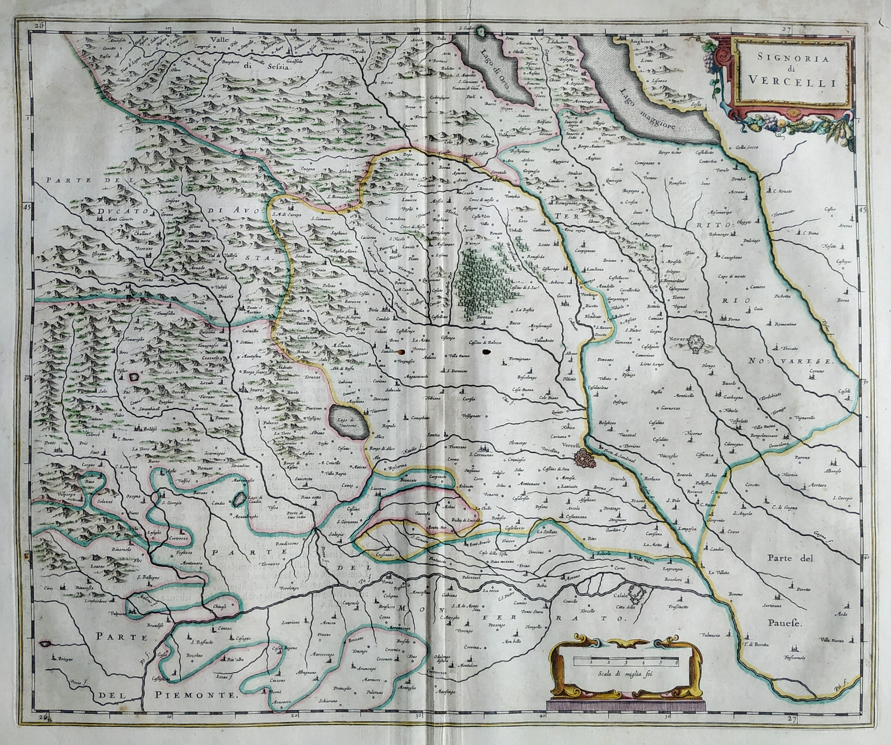
Map title
La signoria di Vercelli
Author
Blaeu
Location shown in map
North-West Italy
Edition date
Circa 1650
Edition place
Amsterdam
Editor
Blaeu
Atlas
Atlas Maior
Price
300 Euro
State
[mint/excellent/VERY GOOD/good/fair/mediocre/poor]
Color
Old colors
Verso
Duch text pag.17
Size
Plate: cm (51 x 41) inches (20.08 x 16.14) Paper: cm (55 x 44) inches (21.65 x 17.32)
Technique
Copper engraving
Note
No particular notes for this maps
Reference
Wiki
Here for more info
In stock
Available
Info
info@thetreasuremaps.com
Code
#0805
×
![La signoria di Vercelli by Blaeu, North-West Italy, Circa 1650]()
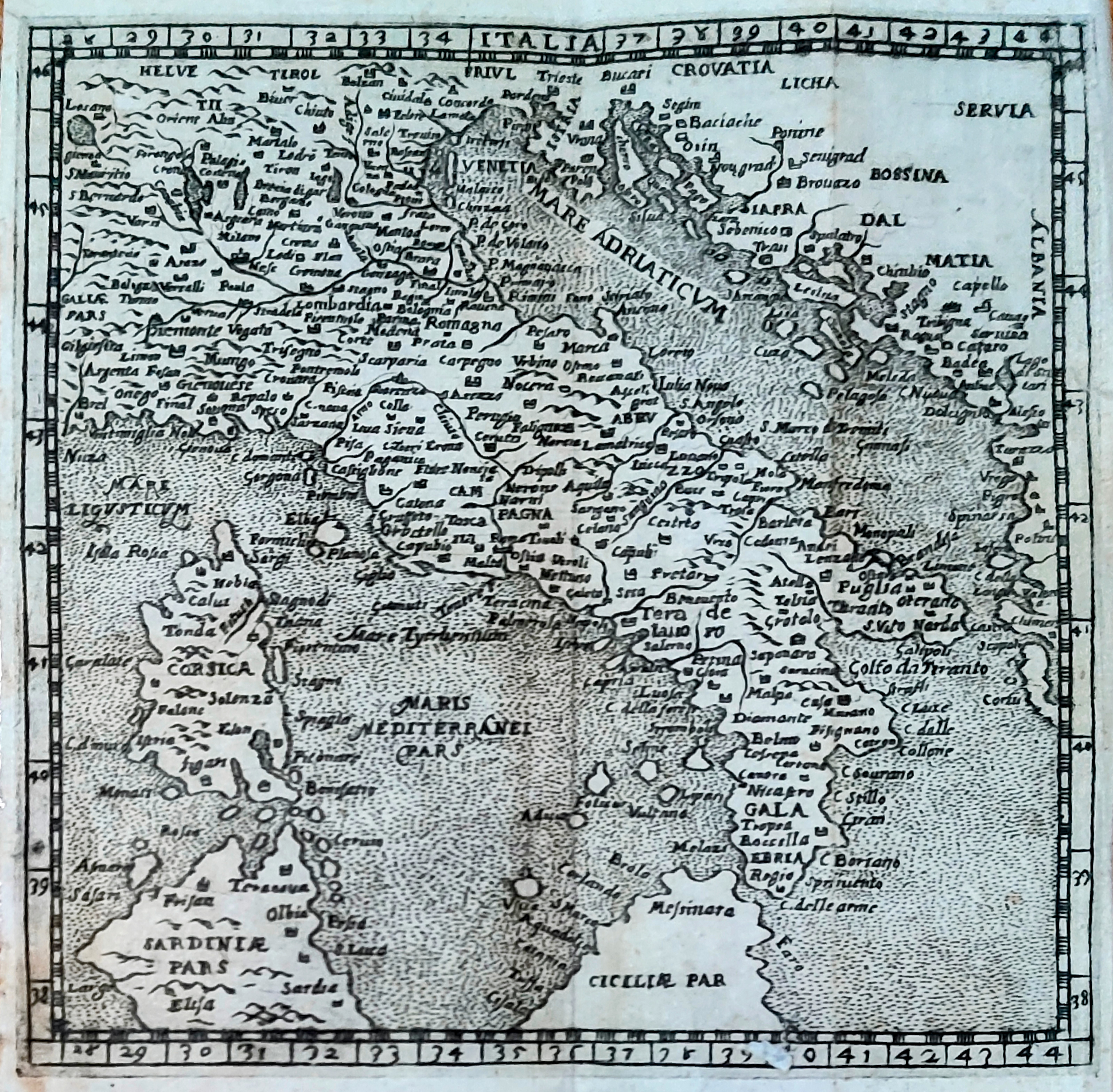
Map title
Italia
Author
Scotto
Location shown in map
Italy
Edition date
1650
Edition place
Venezia
Editor
Atlas
Itinerario
Price
Please ask: info@thetreasuremaps.com
State
[mint/EXCELLENT/very good/good/fair/mediocre/poor]
Color
Black/white
Verso
Blank
Size
Plate: cm (12 x 12) inches (4.72 x 4.72) Paper: cm (14 x 13) inches (5.51 x 5.12)
Technique
Copper engraving
Note
Reference
R.Borri L'Italia nelle antiche carte pag.86
Wiki
Here for more info
In stock
Sold
Info
info@thetreasuremaps.com
Code
#0934
×
![Italia by Scotto, Italy, 1650]()
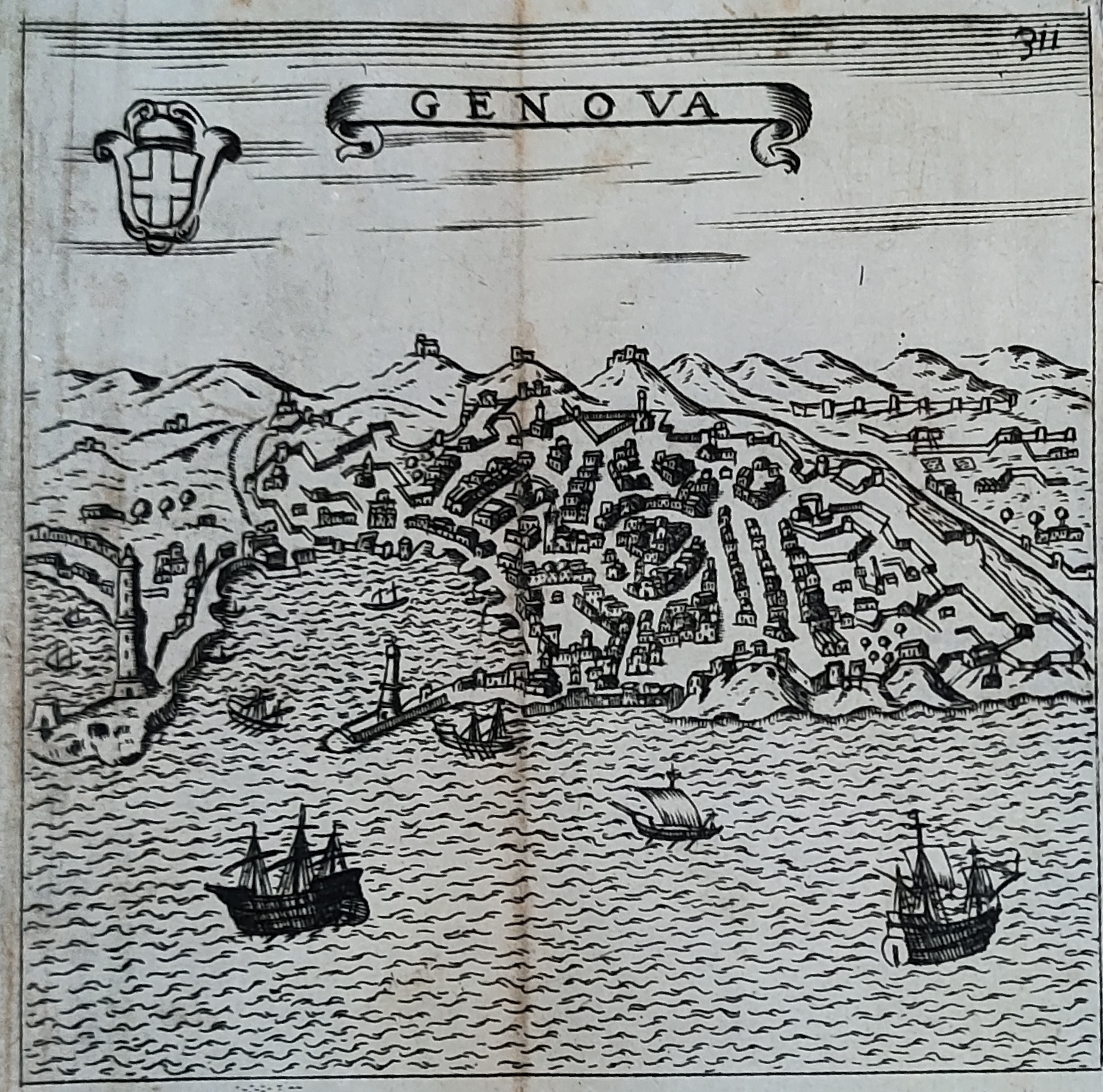
Map title
Genova
Author
Scoto
Location shown in map
Genoa
Edition date
1650
Edition place
Venezia
Editor
Atlas
Itinerario overo nova descrittione de' viaggi principali d'Italia
Price
200 Euro
State
[mint/EXCELLENT/very good/good/fair/mediocre/poor]
Color
Black/white
Verso
Blank
Size
Plate: cm (12 x 12) inches (4.72 x 4.72) Paper: cm (14 x 13) inches (5.51 x 5.12)
Technique
Copper engraving
Note
Reference
Wiki
Here for more info
In stock
Available
Info
info@thetreasuremaps.com
Code
#0949
×
![Genova by Scoto, Genoa, 1650]()
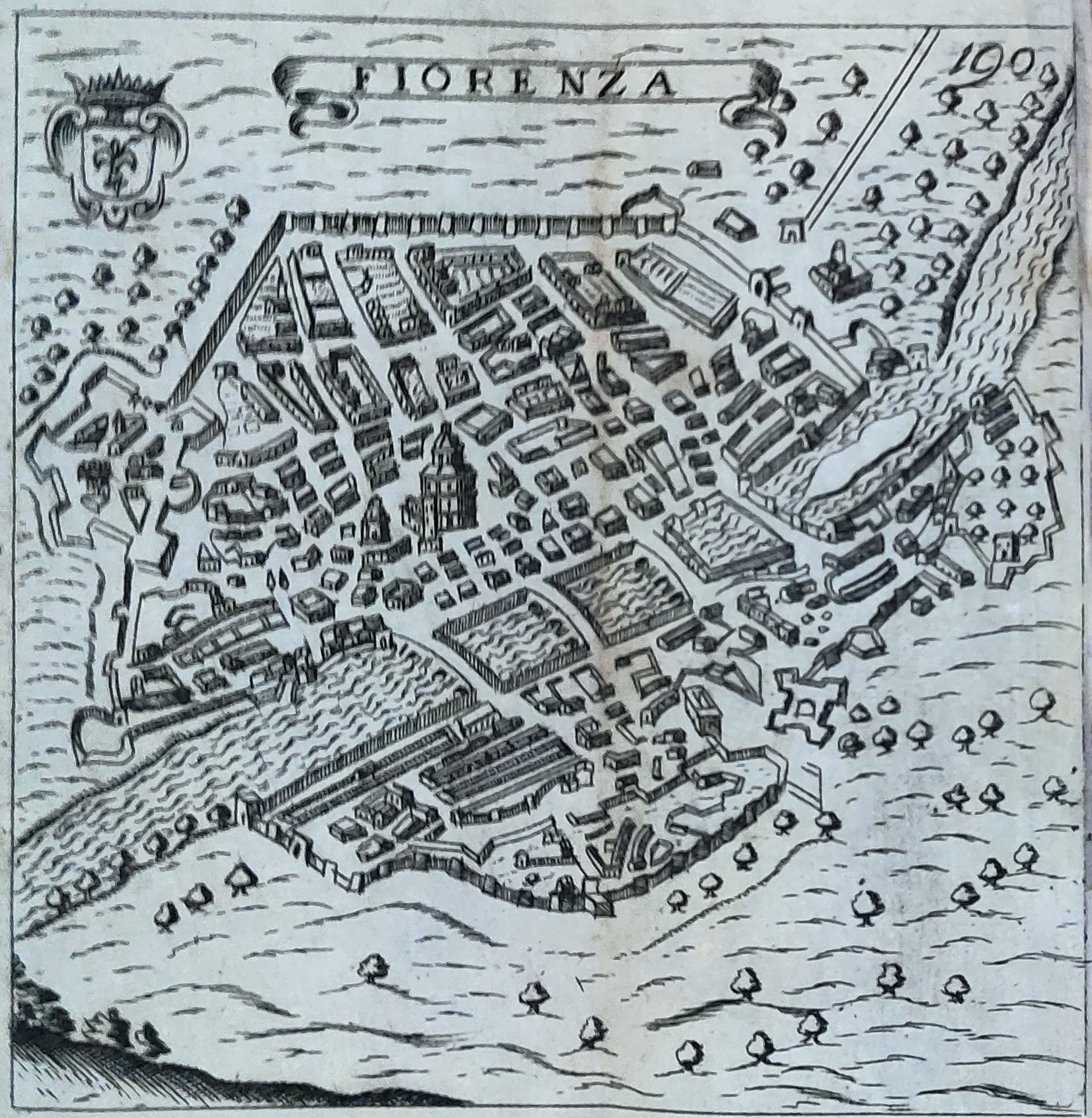
Map title
Florenza
Author
Scotto
Location shown in map
Florence
Edition date
1650
Edition place
Venezia
Editor
Atlas
Itinerario
Price
Please ask: info@thetreasuremaps.com
State
[mint/EXCELLENT/very good/good/fair/mediocre/poor]
Color
Black/white
Verso
Blank
Size
Plate: cm (12 x 12) inches (4.72 x 4.72) Paper: cm (14 x 13) inches (5.51 x 5.12)
Technique
Copper engraving
Note
Reference
Wiki
Here for more info
In stock
Available
Info
info@thetreasuremaps.com
Code
#0950
×
![Florenza by Scotto, Florence, 1650]()
Map title
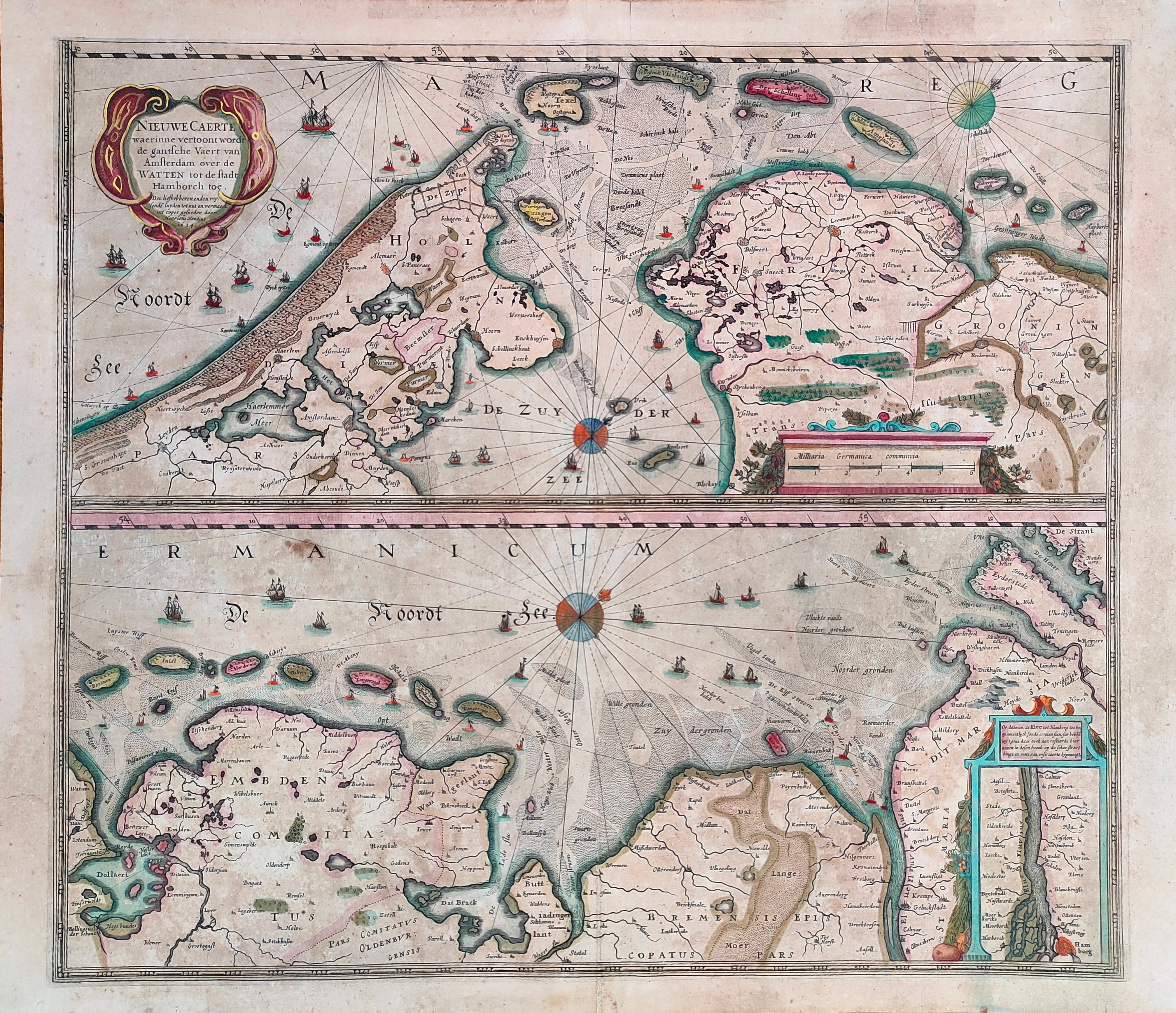
Nieuwe Caerte waerinne vertoont wordt de gantsche Vaert van Amsterdam
Author
Hondius
Location shown in map
Amsterdam
Edition date
Circa 1650
Edition place
Amsterdam
Editor
Hondius
Atlas
Price
400 Euro
State
[mint/EXCELLENT/very good/good/fair/mediocre/poor]
Color
Old colors
Verso
Size
Plate: cm (51 x 45) inches (20.08 x 17.72) Paper: cm (56 x 48) inches (22.05 x 18.9)
Technique
Copper engraving
Note
Reference
Wiki
Here for more info
In stock
Available
Info
info@thetreasuremaps.com
Code
#1231
×
![Nieuwe Caerte waerinne vertoont wordt de gantsche Vaert van Amsterdam by Hondius, Amsterdam, Circa 1650]()
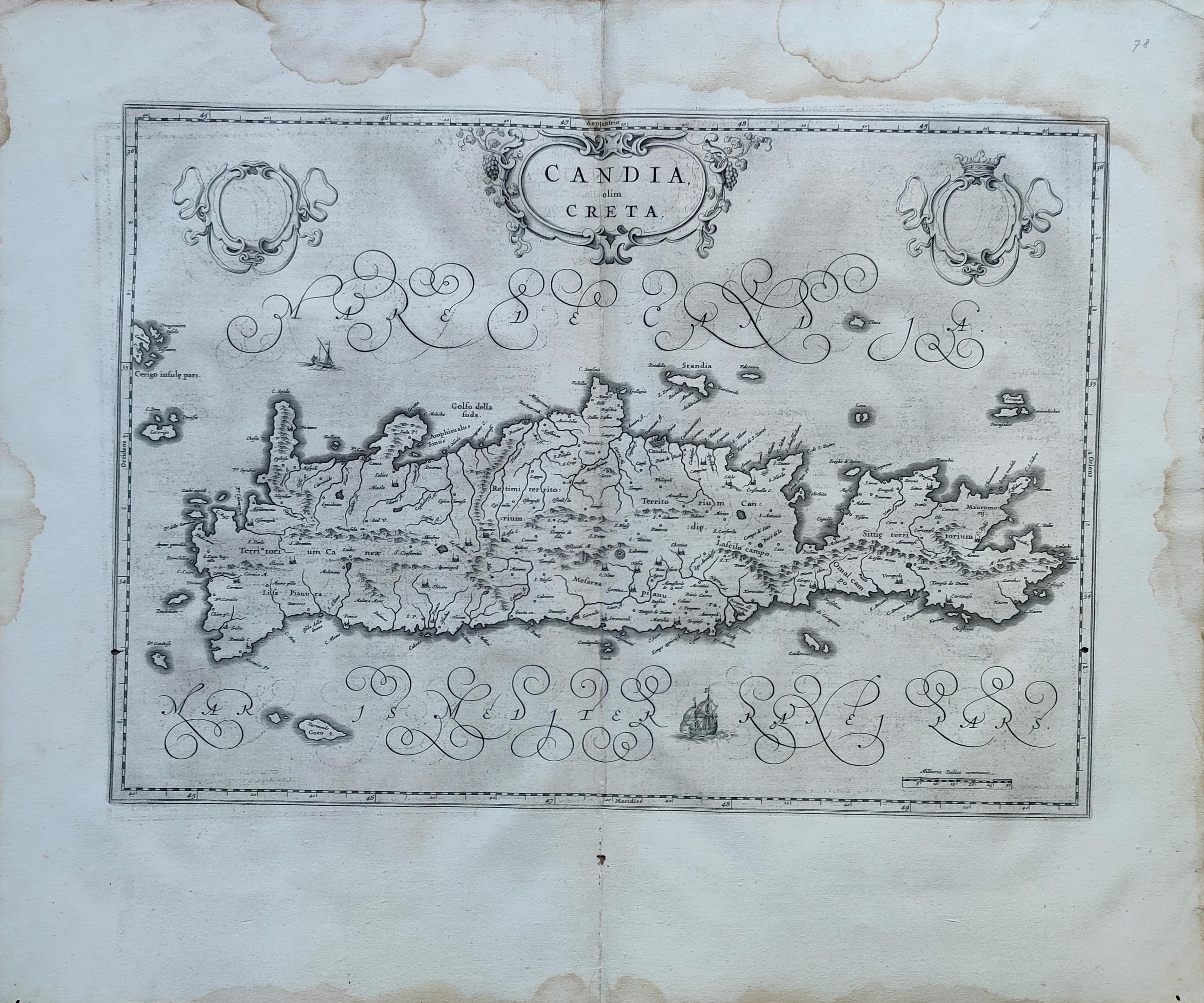
Map title
Candia olim Creta
Author
Blaeu
Location shown in map
Crete
Edition date
Circa 1650
Edition place
Amsterdam
Editor
Blaeu
Atlas
Atlas Maior
Price
300 Euro
State
[mint/EXCELLENT/very good/good/fair/mediocre/poor]
Color
Black/white
Verso
Spanish text
Size
Plate: cm (53 x 39) inches (20.87 x 15.35) Paper: cm (64 x 55) inches (25.2 x 21.65)
Technique
Copper engraving
Note
Reference
Wiki
Here for more info
In stock
Available
Info
info@thetreasuremaps.com
Code
#1271
×
![Candia olim Creta by Blaeu, Crete, Circa 1650]()
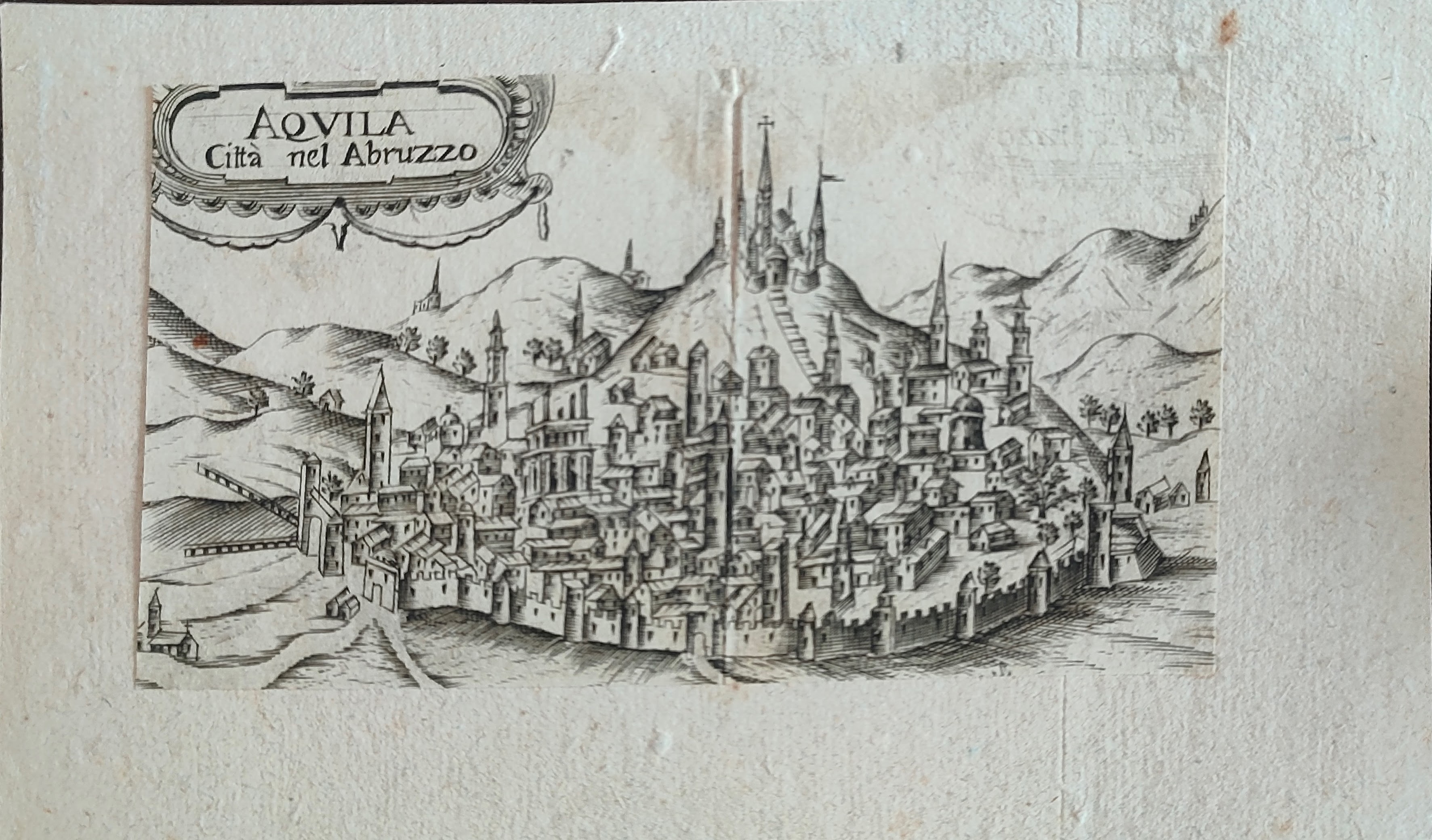
Map title
Aquila citta' nel Abruzzo
Author
Scoto
Location shown in map
Aquila
Edition date
Circa 1650
Edition place
Editor
Atlas
Itinerario overo nova descrittione de' viaggi principali d'Italia
Price
50 Euro
State
[mint/excellent/very good/good/fair/mediocre/POOR
Color
Black/white
Verso
Blank
Size
Plate: cm (14 x 8) inches (5.51 x 3.15) Paper: cm (14 x 8) inches (5.51 x 3.15)
Technique
Copper engraving
Note
Reference
Wiki
Here for more info
In stock
Available
Info
info@thetreasuremaps.com
Code
#1376
×
![Aquila citta' nel Abruzzo by Scoto, Aquila, Circa 1650]()

Map title
Pedemontana regio cum Genvensium territorio & Montisferrati marchionatu
Author
Mercator
Location shown in map
North-West Italy
Edition date
1651
Edition place
Amsterdam
Editor
Janssonius
Atlas
Altas Minor Gerardi Mercatoris
Price
Please ask: info@thetreasuremaps.com
State
[mint/EXCELLENT/very good/good/fair/mediocre/poor]
Color
Black/white
Verso
German text pag 218
Size
Plate: cm (20.3 x 14) inches (7.99 x 5.51) Paper: cm (22.9 x 17.8) inches (9.02 x 7.01)
Technique
Copper engraving
Note
No particular notes for this maps
Reference
--
Wiki
Here for more info
In stock
Sold
Info
info@thetreasuremaps.com
Code
#0447
×
![Pedemontana regio cum Genvensium territorio & Montisferrati marchionatu by Mercator, North-West Italy, 1651]()
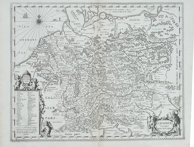
Map title
Germaniae veteris nova descriptio
Author
Jansson
Location shown in map
Germany
Edition date
1652
Edition place
Amsterdam
Editor
--
Atlas
Accuratissima orbis antiqui delineatio.
Price
250 Euro
State
[mint/excellent/VERY GOOD/good/fair/mediocre/poor]
Color
Black/white
Verso
Blank
Size
Plate: cm (47 x 36.8) inches (18.5 x 14.49) Paper: cm (54.6 x 45.7) inches (21.5 x 17.99)
Technique
Copper engraving
Note
Map based on Ortelius' map of ancient Germany.
Reference
--
Wiki
Here for more info
In stock
Available
Info
info@thetreasuremaps.com
Code
#0138
×
![Germaniae veteris nova descriptio by Jansson, Germany, 1652]()
Map title
Situs provinciarum imperii sinici
Author
Martini
Location shown in map
China
Edition date
1654
Edition place
Cologne
Editor
Atlas
De bello Tartarico historia
Price
400 Euro
State
[mint/EXCELLENT/very good/good/fair/mediocre/poor]
Color
Black/white
Verso
Blank
Size
Plate: cm (16 x 13) inches (6.3 x 5.12) Paper: cm (19 x 18) inches (7.48 x 7.09)
Technique
Copper engraving
Note
Reference
--
Wiki
Here for more info
In stock
Available
Info
info@thetreasuremaps.com
Code
#1202
×
![Situs provinciarum imperii sinici by Martini, China, 1654]()
Map title
Imperii Sinarum Nova Descriptio
Author
Blaeu
Location shown in map
China
Edition date
1655
Edition place
Amsterdam
Editor
Atlas
Atlas Sinensis
Price
1100 Euro
State
[mint/excellent/very good/good/fair/MEDIOCRE/poor]
Color
Old colors
Verso
Blank
Size
Plate: cm (60 x 46) inches (23.62 x 18.11) Paper: cm (60 x 46) inches (23.62 x 18.11)
Technique
Copper engraving
Note
No particular notes for this maps.
Reference
--
Wiki
Here for more info
In stock
Available
Info
info@thetreasuremaps.com
Code
#0938
×
![Imperii Sinarum Nova Descriptio by Blaeu, China, 1655]()
Map title
Les isles Antilles
Author
Sanson
Location shown in map
Antilles islands
Edition date
1656
Edition place
Paris
Editor
--
Atlas
Cartes generales de toutes les parties du monde -- Pierre Mariette
Price
600 Euro
State
[mint/EXCELLENT/very good/good/fair/mediocre/poor]
Color
Black/white
Verso
Blank
Size
Plate: cm (53.3 x 38.1) inches (20.98 x 15) Paper: cm (53.3 x 43.2) inches (20.98 x 17.01)
Technique
Copper engraving
Note
Professionally repaired
Reference
--
Wiki
Here for more info
In stock
Available
Info
info@thetreasuremaps.com
Code
#0343
×
![Les isles Antilles by Sanson, Antilles islands, 1656]()
Map title
Carte generale des royaume d'Angleterre
Author
Sanson
Location shown in map
British Isles
Edition date
1658
Edition place
Paris
Editor
Melchior Tavenier
Atlas
Price
350 Euro
State
[mint/excellent/VERY GOOD/good/fair/mediocre/poor]
Color
Old colors
Verso
Blank
Size
Plate: cm (52 x 39) inches (20.47 x 15.35) Paper: cm (57 x 44) inches (22.44 x 17.32)
Technique
Copper engraving
Note
Reference
Wiki
Here for more info
In stock
Available
Info
info@thetreasuremaps.com
Code
#1173
×
![Carte generale des royaume d'Angleterre by Sanson, British Isles, 1658]()
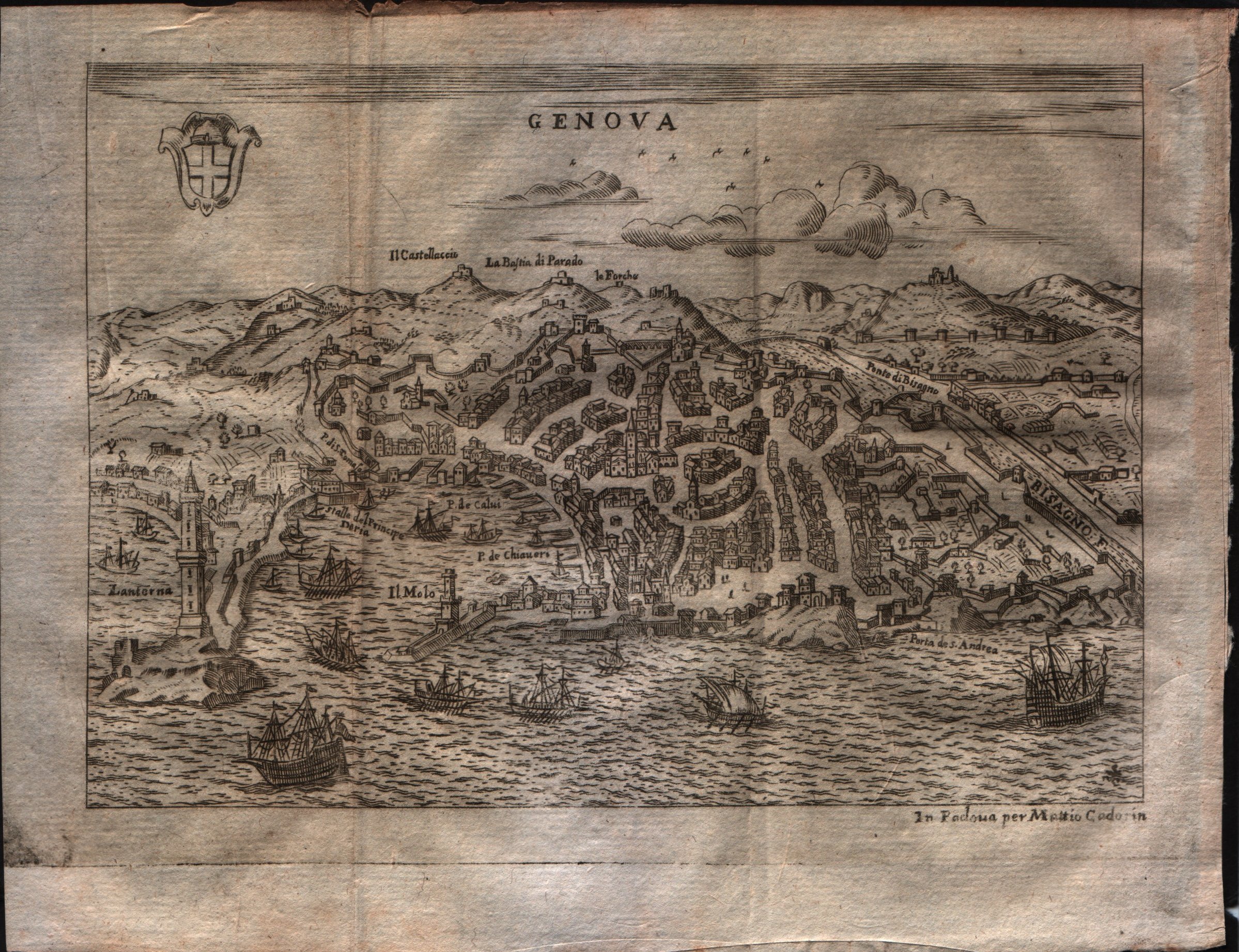
Map title
Genova
Author
Scoto
Location shown in map
Genoa
Edition date
1659
Edition place
Padova
Editor
Cadorin
Atlas
Itinerario overo nova descrittione de' viaggi principali d'Italia
Price
200 Euro
State
[mint/EXCELLENT/very good/good/fair/mediocre/poor]
Color
Black/white
Verso
Blank
Size
Plate: cm (17.8 x 12.7) inches (7.01 x 5) Paper: cm (20.3 x 16.5) inches (7.99 x 6.5)
Technique
Copper engraving
Note
--
Reference
--
Wiki
Here for more info
In stock
Available
Info
info@thetreasuremaps.com
Code
#0528
×
![Genova by Scoto, Genoa, 1659]()
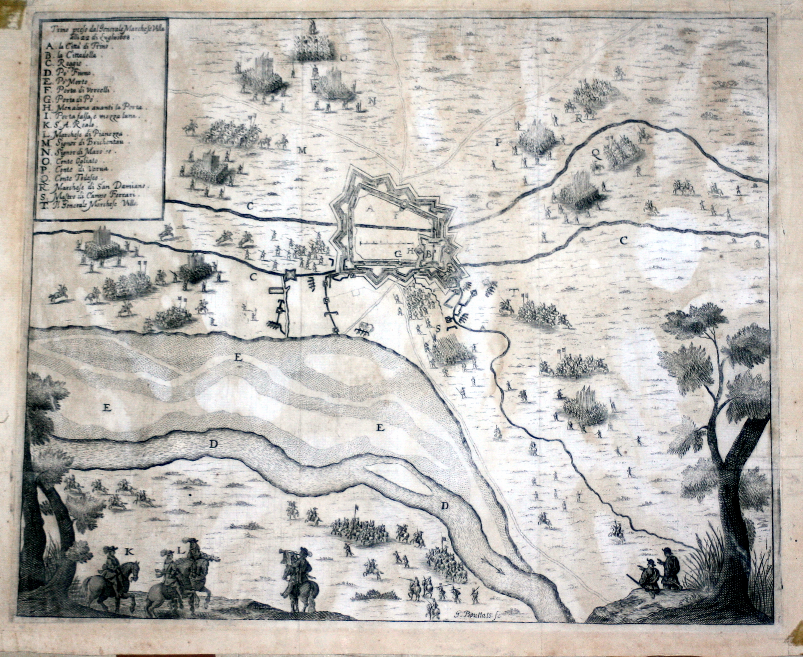
Map title
Trino preso dal generale marchese Villa
Author
Merian
Location shown in map
Trino
Edition date
1659
Edition place
Editor
--
Atlas
Historia di Leopoldo Cesari
Price
Please ask: info@thetreasuremaps.com
State
[mint/EXCELLENT/very good/good/fair/mediocre/poor]
Color
Black/white
Verso
White
Size
Plate: cm (39.4 x 31.8) inches (15.51 x 12.52) Paper: cm (41.9 x 34.3) inches (16.5 x 13.5)
Technique
Copper engraving
Note
No particular notes for this maps.
Reference
--
Wiki
Here for more info
In stock
Available
Info
info@thetreasuremaps.com
Code
#0542
×
![Trino preso dal generale marchese Villa by Merian, Trino, 1659]()
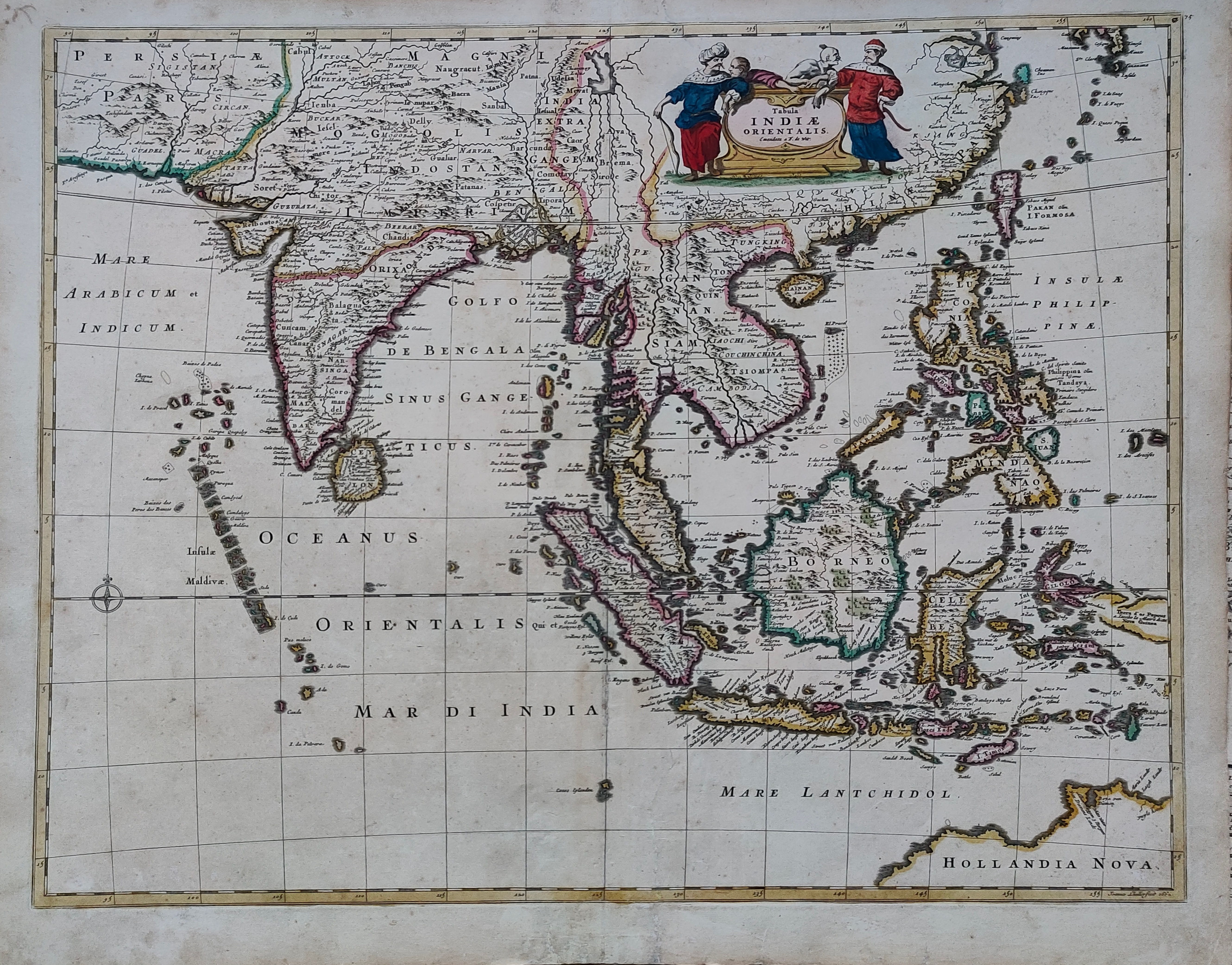
Map title
Tabula Indiae Orientalis
Author
De Witt
Location shown in map
South East
Edition date
Circa 1662
Edition place
Amsterdam
Editor
Atlas
Price
1200 Euro
State
[mint/EXCELLENT/very good/good/fair/mediocre/poor]
Color
Old colors
Verso
Blank
Size
Plate: cm (58 x 46) inches (22.83 x 18.11) Paper: cm (62 x 53) inches (24.41 x 20.87)
Technique
Copper engraving
Note
Reference
Wiki
Here for more info
In stock
Available
Info
info@thetreasuremaps.com
Code
#1261
×
![Tabula Indiae Orientalis by De Witt, South East, Circa 1662]()