1700-1799
Map title
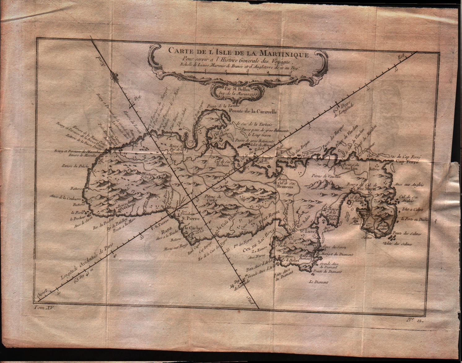
Carte de l'isle de la Martinique
Author
Bellin
Location shown in map
Martinique
Edition date
1757
Edition place
Paris
Editor
--
Atlas
Historie General des Voyages -- Prevost
Price
150 Euro
State
[mint/EXCELLENT/very good/good/fair/mediocre/poor]
Color
Black/white
Verso
Blank
Size
Plate: cm (29.2 x 20.3) inches (11.5 x 7.99) Paper: cm (34.3 x 25.4) inches (13.5 x 10)
Technique
Copper engraving
Note
No particular notes for this maps
Reference
--
Wiki
Here for more info
In stock
Available
Info
info@thetreasuremaps.com
Code
#0357
×
![Carte de l'isle de la Martinique by Bellin, Martinique, 1757]()
Map title
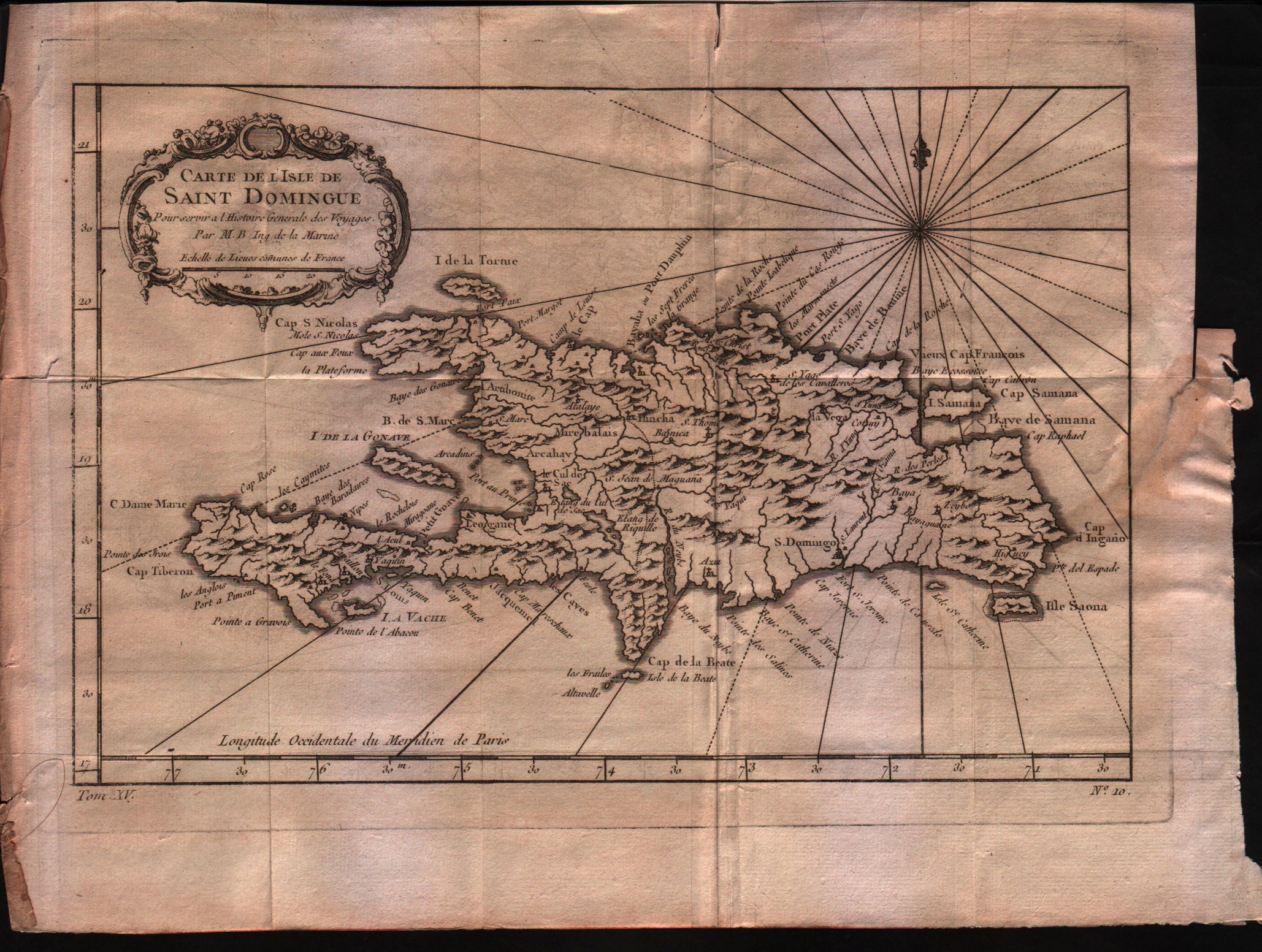
Carte de l'isle de Saint Domingue
Author
Bellin
Location shown in map
Haiti
Edition date
1757
Edition place
Paris
Editor
--
Atlas
Historie General des Voyages -- Prevost
Price
150 Euro
State
[mint/EXCELLENT/very good/good/fair/mediocre/poor]
Color
Black/white
Verso
Blank
Size
Plate: cm (27.9 x 20.3) inches (10.98 x 7.99) Paper: cm (33 x 25.4) inches (12.99 x 10)
Technique
Copper engraving
Note
No particular notes for this maps
Reference
--
Wiki
Here for more info
In stock
Available
Info
info@thetreasuremaps.com
Code
#0356
×
![Carte de l'isle de Saint Domingue by Bellin, Haiti, 1757]()
Map title
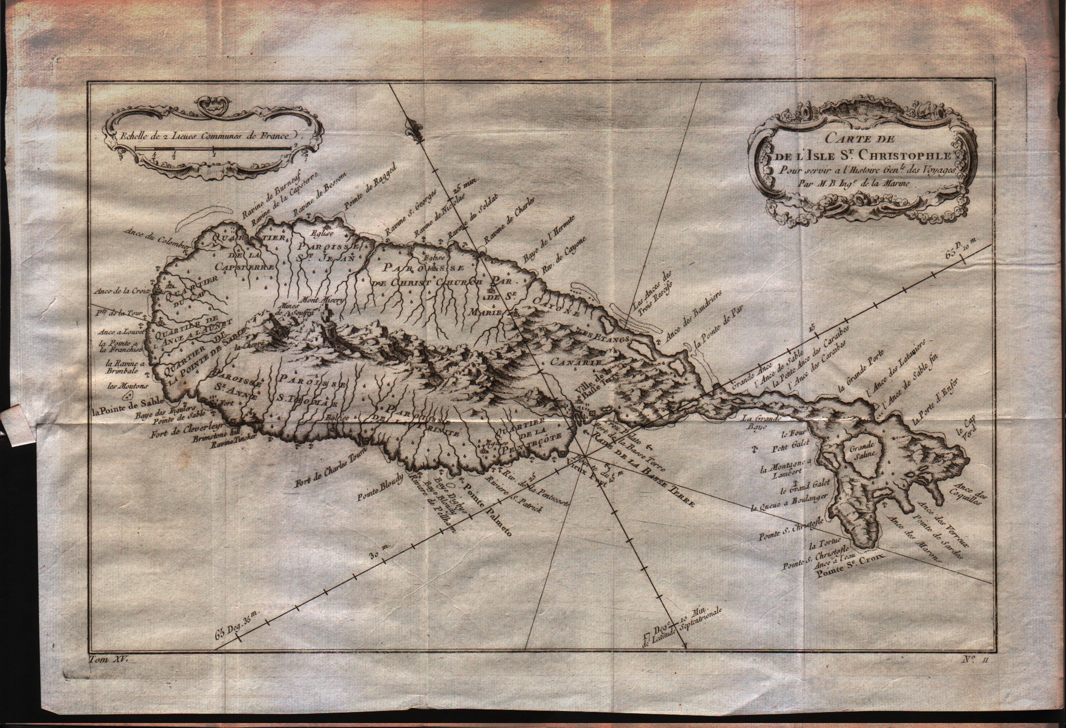
Carte de l'isle St.Christophle
Author
Bellin
Location shown in map
St.Christopher
Edition date
1757
Edition place
Paris
Editor
--
Atlas
Historie General des Voyages -- Prevost
Price
150 Euro
State
[mint/EXCELLENT/very good/good/fair/mediocre/poor]
Color
Black/white
Verso
Blank
Size
Plate: cm (30.5 x 20.3) inches (12.01 x 7.99) Paper: cm (34.3 x 24.1) inches (13.5 x 9.49)
Technique
Copper engraving
Note
No particular notes for this maps
Reference
--
Wiki
Here for more info
In stock
Available
Info
info@thetreasuremaps.com
Code
#0355
×
![Carte de l'isle St.Christophle by Bellin, St.Christopher, 1757]()
Map title
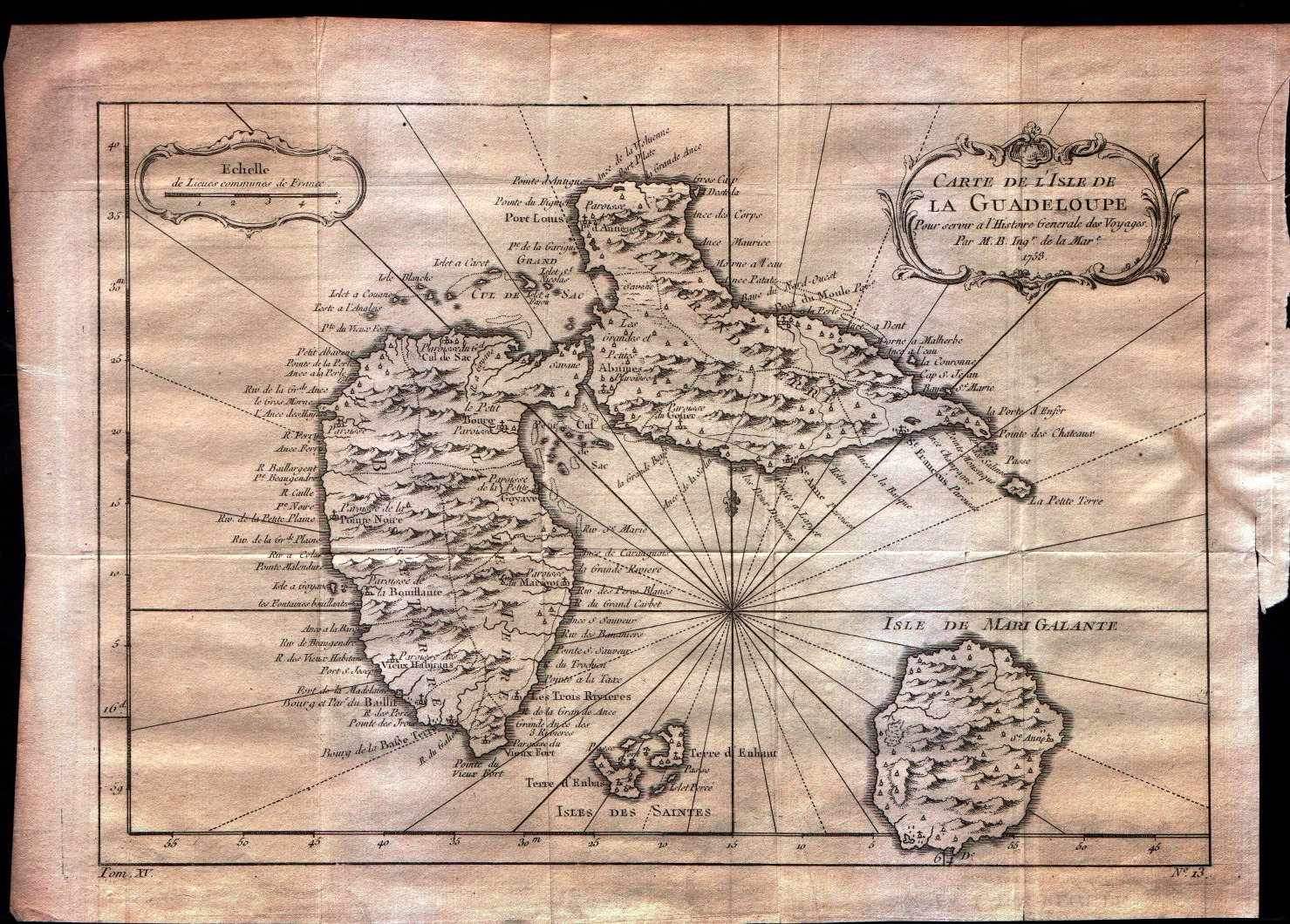
Carte de l'isle de la Guadeloupe
Author
Bellin
Location shown in map
Guadeloupe
Edition date
1757
Edition place
Paris
Editor
--
Atlas
Historie General des Voyages -- Prevost
Price
150 Euro
State
[mint/EXCELLENT/very good/good/fair/mediocre/poor]
Color
Black/white
Verso
Blank
Size
Plate: cm (30.5 x 21.6) inches (12.01 x 8.5) Paper: cm (34.3 x 25.4) inches (13.5 x 10)
Technique
Copper engraving
Note
No particular notes for this maps
Reference
--
Wiki
Here for more info
In stock
Available
Info
info@thetreasuremaps.com
Code
#0354
×
![Carte de l'isle de la Guadeloupe by Bellin, Guadeloupe, 1757]()
Map title
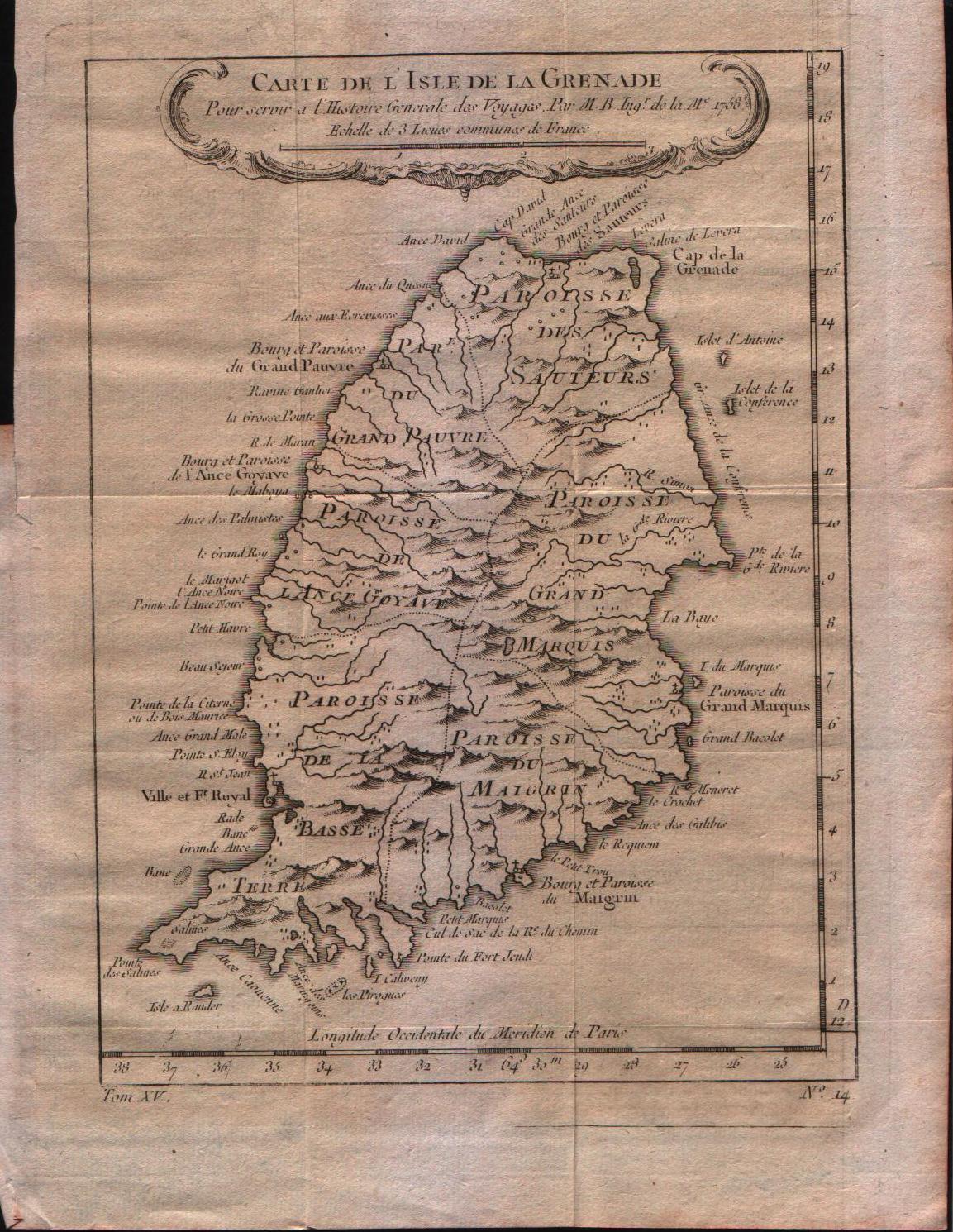
Carte de l'isle de la Grenade
Author
Bellin
Location shown in map
Grenada
Edition date
1757
Edition place
Paris
Editor
--
Atlas
Historie General des Voyages -- Prevost
Price
150 Euro
State
[mint/EXCELLENT/very good/good/fair/mediocre/poor]
Color
Black/white
Verso
Blank
Size
Plate: cm (15.2 x 21.6) inches (5.98 x 8.5) Paper: cm (20.3 x 25.4) inches (7.99 x 10)
Technique
Copper engraving
Note
No particular notes for this maps
Reference
--
Wiki
Here for more info
In stock
Available
Info
info@thetreasuremaps.com
Code
#0353
×
![Carte de l'isle de la Grenade by Bellin, Grenada, 1757]()

Map title
Carte de l'entree de la riviere de Canton
Author
Bellin
Location shown in map
--
Edition date
1757
Edition place
Paris
Editor
--
Atlas
Historie General des Voyages -- Prevost
Price
Please ask: info@thetreasuremaps.com
State
[mint/excellent/VERY GOOD/good/fair/mediocre/poor]
Color
Black/white
Verso
Blank
Size
Plate: cm (20.3 x 25.4) inches (7.99 x 10) Paper: cm (21.6 x 26.7) inches (8.5 x 10.51)
Technique
Copper engraving
Note
No particular notes for this maps
Reference
--
Wiki
Here for more info
In stock
Sold
Info
info@thetreasuremaps.com
Code
#0245
×
![Carte de l'entree de la riviere de Canton by Bellin, --, 1757]()
Map title
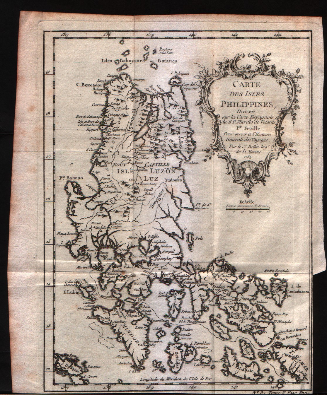
Carte des Isles Philippines 1Feuille
Author
Bellin
Location shown in map
Philippines
Edition date
1757
Edition place
Paris
Editor
--
Atlas
Historie General des Voyages -- Prevost
Price
200 Euro
State
[mint/EXCELLENT/very good/good/fair/mediocre/poor]
Color
Black/white
Verso
Blank
Size
Plate: cm (15.2 x 20.3) inches (5.98 x 7.99) Paper: cm (17.8 x 21.6) inches (7.01 x 8.5)
Technique
Copper engraving
Note
No particular notes for this maps
Reference
--
Wiki
Here for more info
In stock
Available
Info
info@thetreasuremaps.com
Code
#0234
×
![Carte des Isles Philippines 1Feuille by Bellin, Philippines , 1757]()
Map title
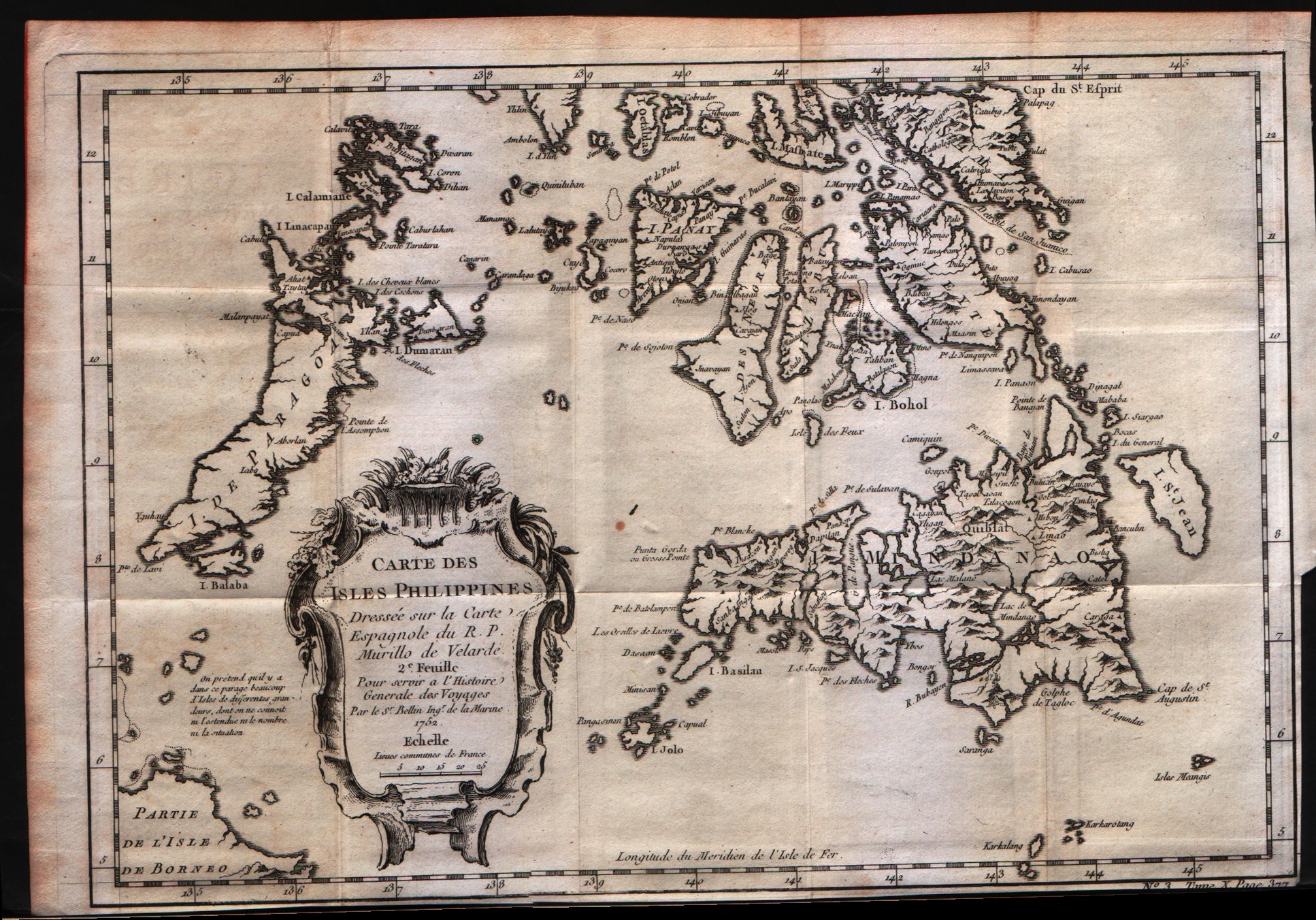
Carte des Isles Philippines 2Feuille
Author
Bellin
Location shown in map
Philippines
Edition date
1757
Edition place
Paris
Editor
--
Atlas
Historie General des Voyages -- Prevost
Price
200 Euro
State
[mint/EXCELLENT/very good/good/fair/mediocre/poor]
Color
Black/white
Verso
Blank
Size
Plate: cm (30.5 x 20.3) inches (12.01 x 7.99) Paper: cm (31.8 x 22.9) inches (12.52 x 9.02)
Technique
Copper engraving
Note
No particular notes for this maps
Reference
--
Wiki
Here for more info
In stock
Available
Info
info@thetreasuremaps.com
Code
#0235
×
![Carte des Isles Philippines 2Feuille by Bellin, Philippines , 1757]()
Map title
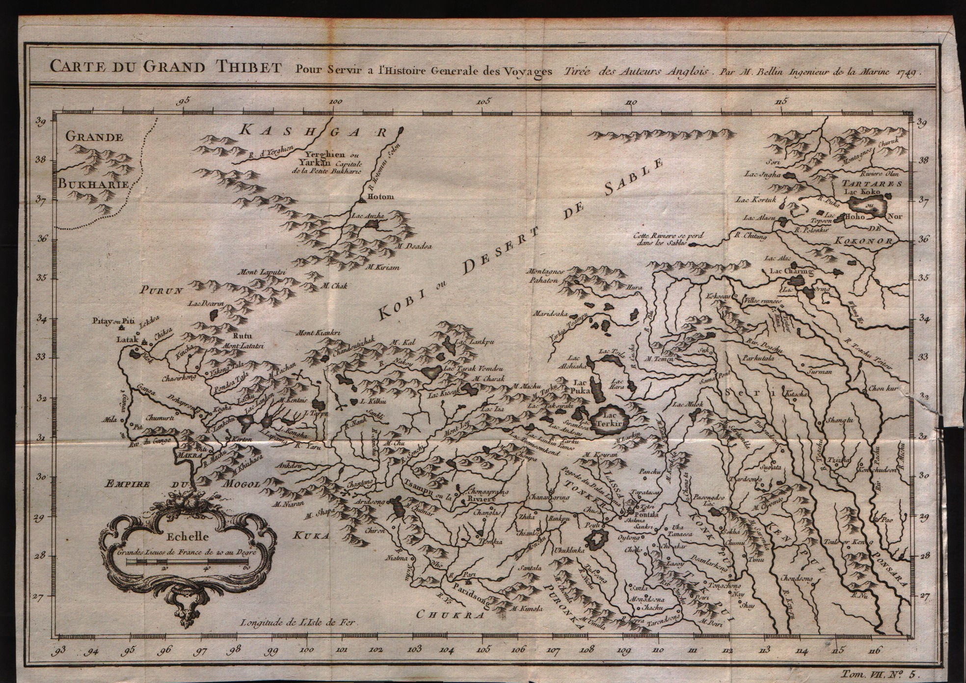
Carte du grand Thibet
Author
Bellin
Location shown in map
--
Edition date
1757
Edition place
Paris
Editor
--
Atlas
Historie General des Voyages -- Prevost
Price
Please ask: info@thetreasuremaps.com
State
[mint/EXCELLENT/very good/good/fair/mediocre/poor]
Color
Black/white
Verso
Blank
Size
Plate: cm (30.5 x 21.6) inches (12.01 x 8.5) Paper: cm (31.8 x 22.9) inches (12.52 x 9.02)
Technique
Copper engraving
Note
No particular notes for this maps
Reference
--
Wiki
Here for more info
In stock
Available
Info
info@thetreasuremaps.com
Code
#0236
×
![Carte du grand Thibet by Bellin, --, 1757]()
Map title
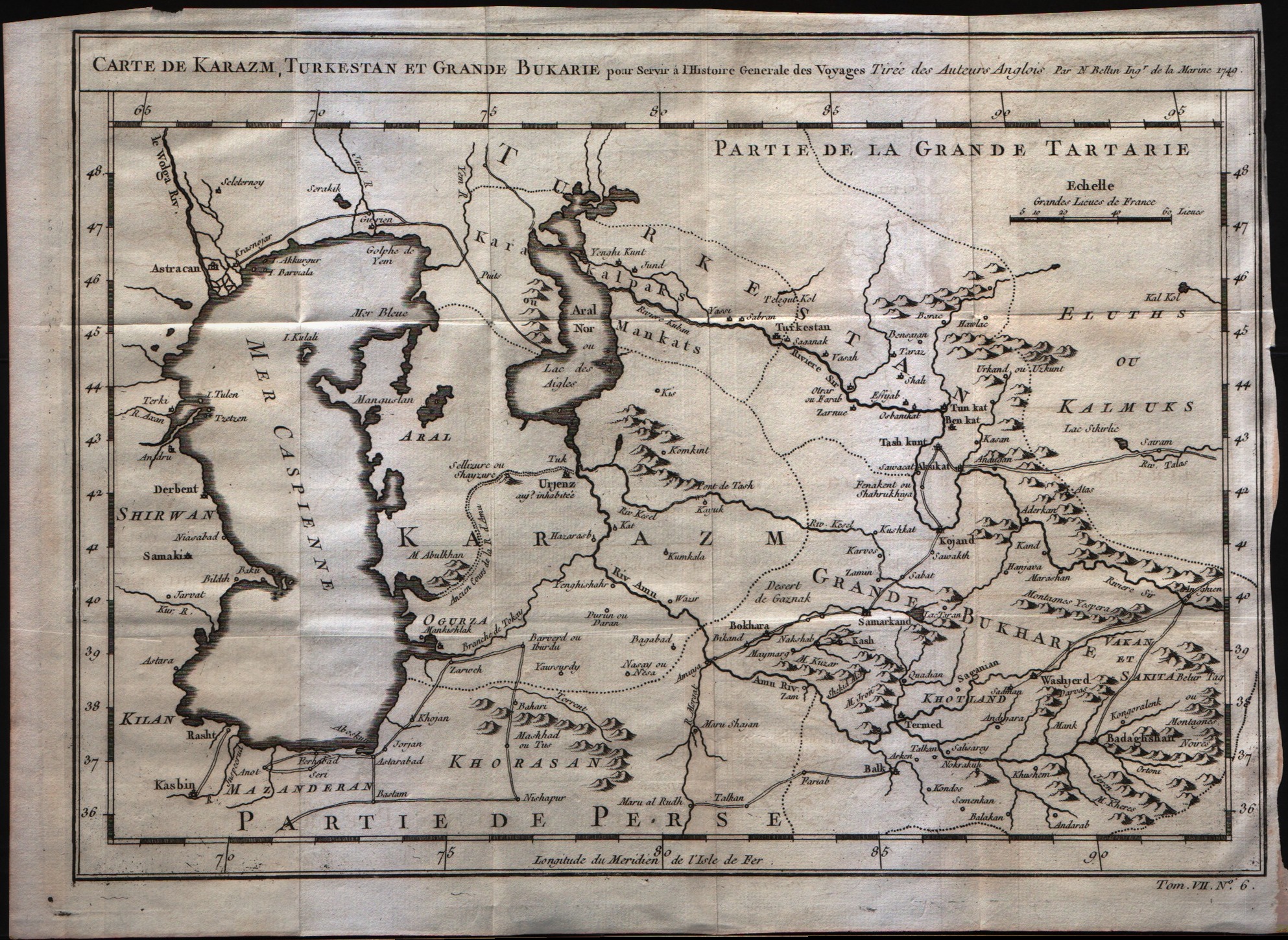
Carte de Karazm, Turkestan et Grande Bukarie
Author
Bellin
Location shown in map
--
Edition date
1757
Edition place
Paris
Editor
--
Atlas
Historie General des Voyages -- Prevost
Price
Please ask: info@thetreasuremaps.com
State
[mint/EXCELLENT/very good/good/fair/mediocre/poor]
Color
Black/white
Verso
Blank
Size
Plate: cm (30.5 x 21.6) inches (12.01 x 8.5) Paper: cm (33 x 24.1) inches (12.99 x 9.49)
Technique
Copper engraving
Note
No particular notes for this maps
Reference
--
Wiki
Here for more info
In stock
Available
Info
info@thetreasuremaps.com
Code
#0237
×
![Carte de Karazm, Turkestan et Grande Bukarie by Bellin, --, 1757]()
Map title
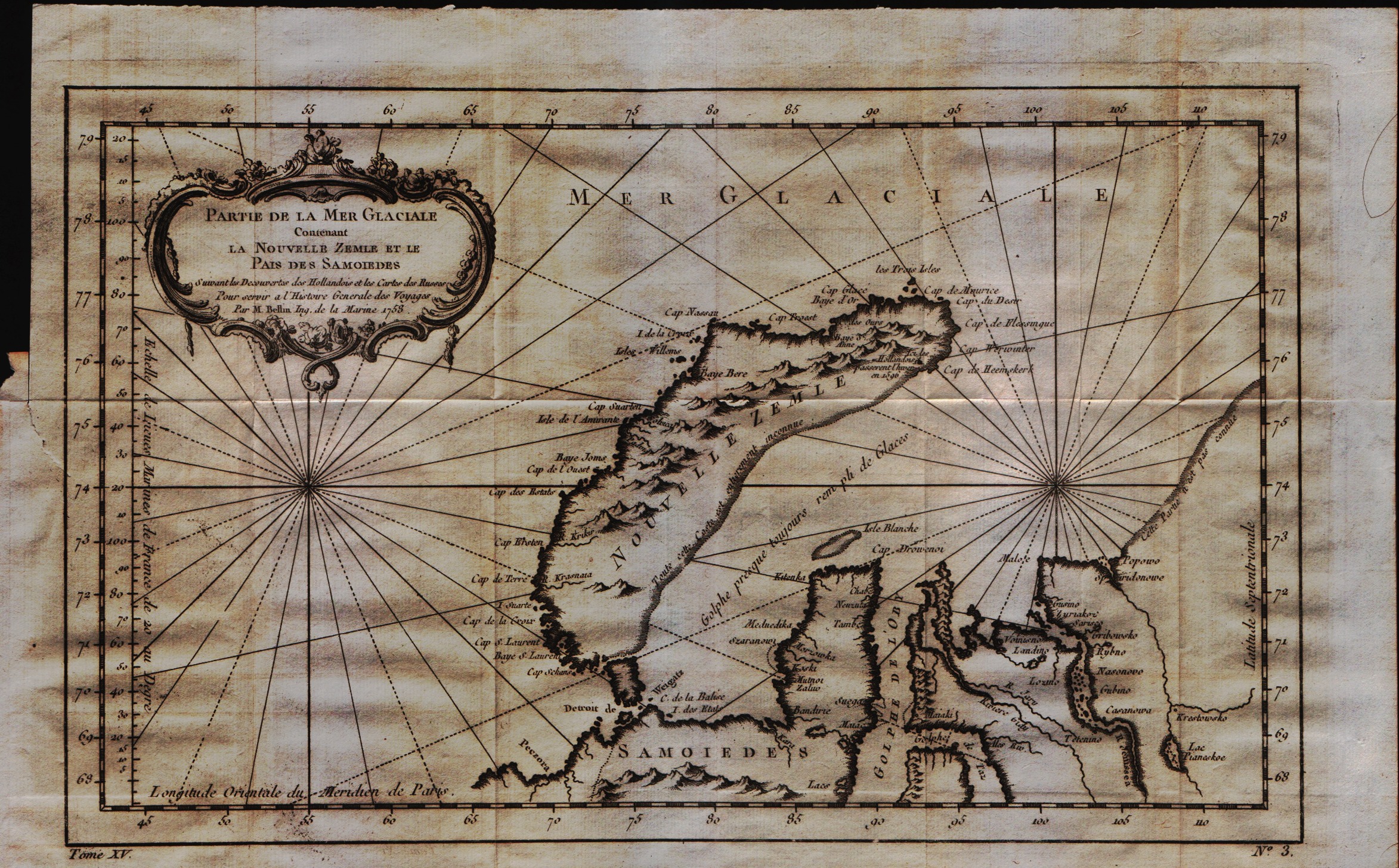
Partie de la mer Glaciale contenant la Nouvelle Zemle et le pais des Samoidedes
Author
Bellin
Location shown in map
--
Edition date
1757
Edition place
Paris
Editor
--
Atlas
Historie General des Voyages -- Prevost
Price
Please ask: info@thetreasuremaps.com
State
[mint/EXCELLENT/very good/good/fair/mediocre/poor]
Color
Black/white
Verso
Blank
Size
Plate: cm (33 x 21.6) inches (12.99 x 8.5) Paper: cm (39.4 x 25.4) inches (15.51 x 10)
Technique
Copper engraving
Note
No particular notes for this maps
Reference
--
Wiki
Here for more info
In stock
Available
Info
info@thetreasuremaps.com
Code
#0238
×
![Partie de la mer Glaciale contenant la Nouvelle Zemle et le pais des Samoidedes by Bellin, --, 1757]()
Map title
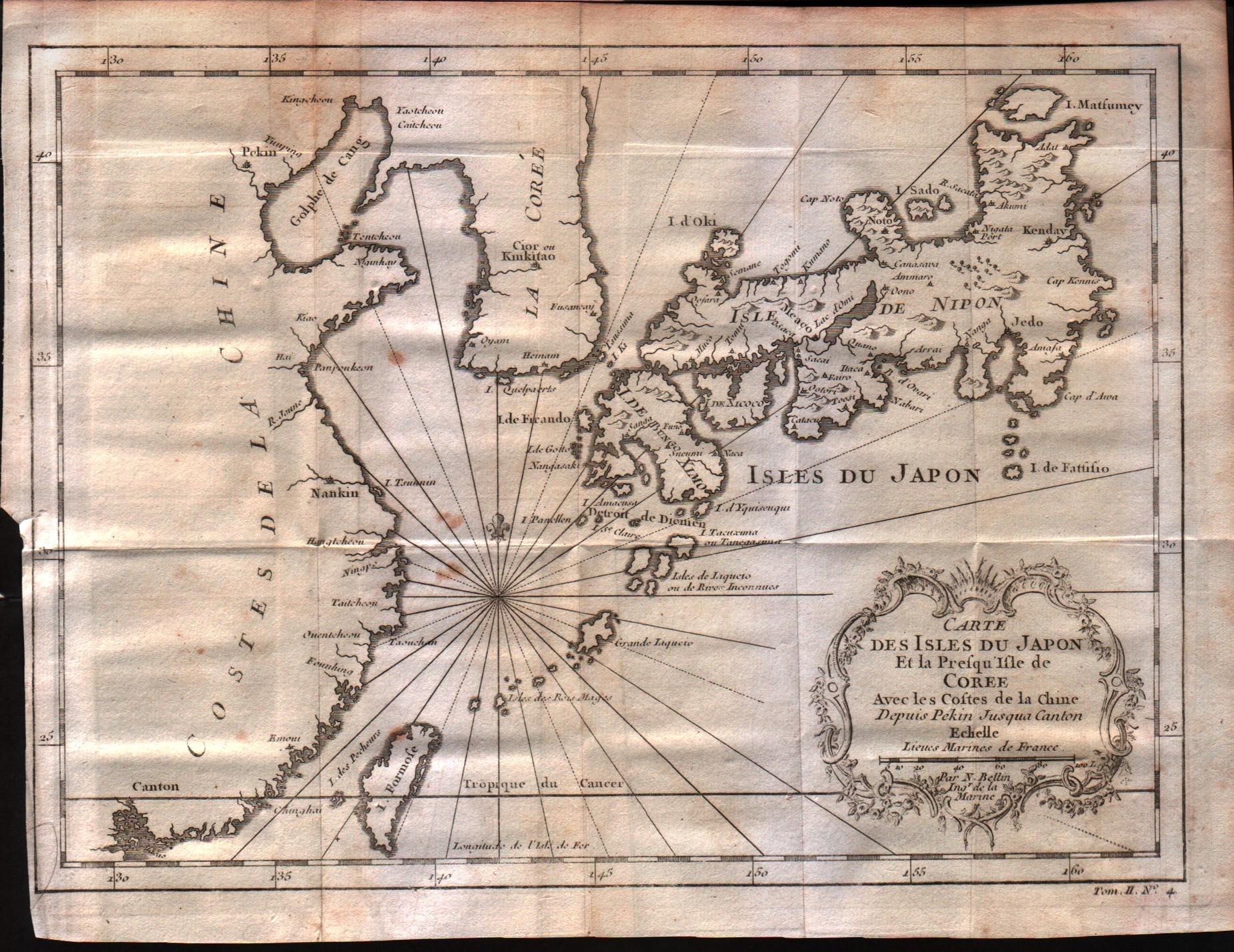
Carte des isles du Japon et la peresqu'isle de Coree avec les costes de la Chine depuis Pekin jusqua Canton
Author
Bellin
Location shown in map
Japan
Edition date
1757
Edition place
Paris
Editor
--
Atlas
Historie General des Voyages -- Prevost
Price
250 Euro
State
[mint/EXCELLENT/very good/good/fair/mediocre/poor]
Color
Black/white
Verso
Blank
Size
Plate: cm (27.9 x 21.6) inches (10.98 x 8.5) Paper: cm (30.5 x 22.9) inches (12.01 x 9.02)
Technique
Copper engraving
Note
No particular notes for this maps
Reference
--
Wiki
Here for more info
In stock
Available
Info
info@thetreasuremaps.com
Code
#0239
×
![Carte des isles du Japon et la peresqu'isle de Coree avec les costes de la Chine depuis Pekin jusqua Canton by Bellin, Japan, 1757]()
Map title
Carte de la Province de Quan-tong ou Lyau-tong et du Royaume de Kau-li ou Coree
Author
Bellin
Location shown in map
Korea
Edition date
1757
Edition place
Paris
Editor
--
Atlas
Historie General des Voyages -- Prevost
Price
Please ask: info@thetreasuremaps.com
State
[mint/excellent/VERY GOOD/good/fair/mediocre/poor]
Color
Black/white
Verso
Blank
Size
Plate: cm (21.6 x 26.7) inches (8.5 x 10.51) Paper: cm (22.9 x 27.9) inches (9.02 x 10.98)
Technique
Copper engraving
Note
No particular notes for this maps
Reference
--
Wiki
Here for more info
In stock
Sold
Info
info@thetreasuremaps.com
Code
#0240
×
![Carte de la Province de Quan-tong ou Lyau-tong et du Royaume de Kau-li ou Coree by Bellin, Korea, 1757]()
Map title
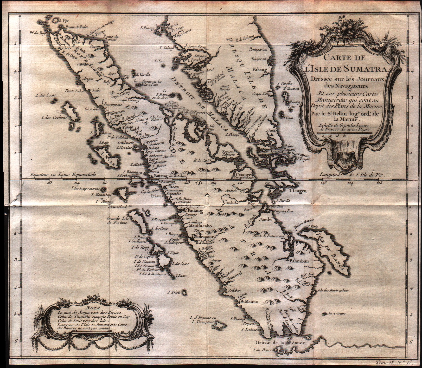
Carte De L'Isle de Sumatra
Author
Bellin
Location shown in map
--
Edition date
1757
Edition place
Paris
Editor
--
Atlas
Historie General des Voyages -- Prevost
Price
Please ask: info@thetreasuremaps.com
State
[mint/excellent/VERY GOOD/good/fair/mediocre/poor]
Color
Black/white
Verso
Blank
Size
Plate: cm (29.2 x 26.7) inches (11.5 x 10.51) Paper: cm (29.2 x 26) inches (11.5 x 10.24)
Technique
Copper engraving
Note
No particular notes for this maps
Reference
--
Wiki
Here for more info
In stock
Available
Info
info@thetreasuremaps.com
Code
#0241
×
![Carte De L'Isle de Sumatra by Bellin, --, 1757]()
Map title
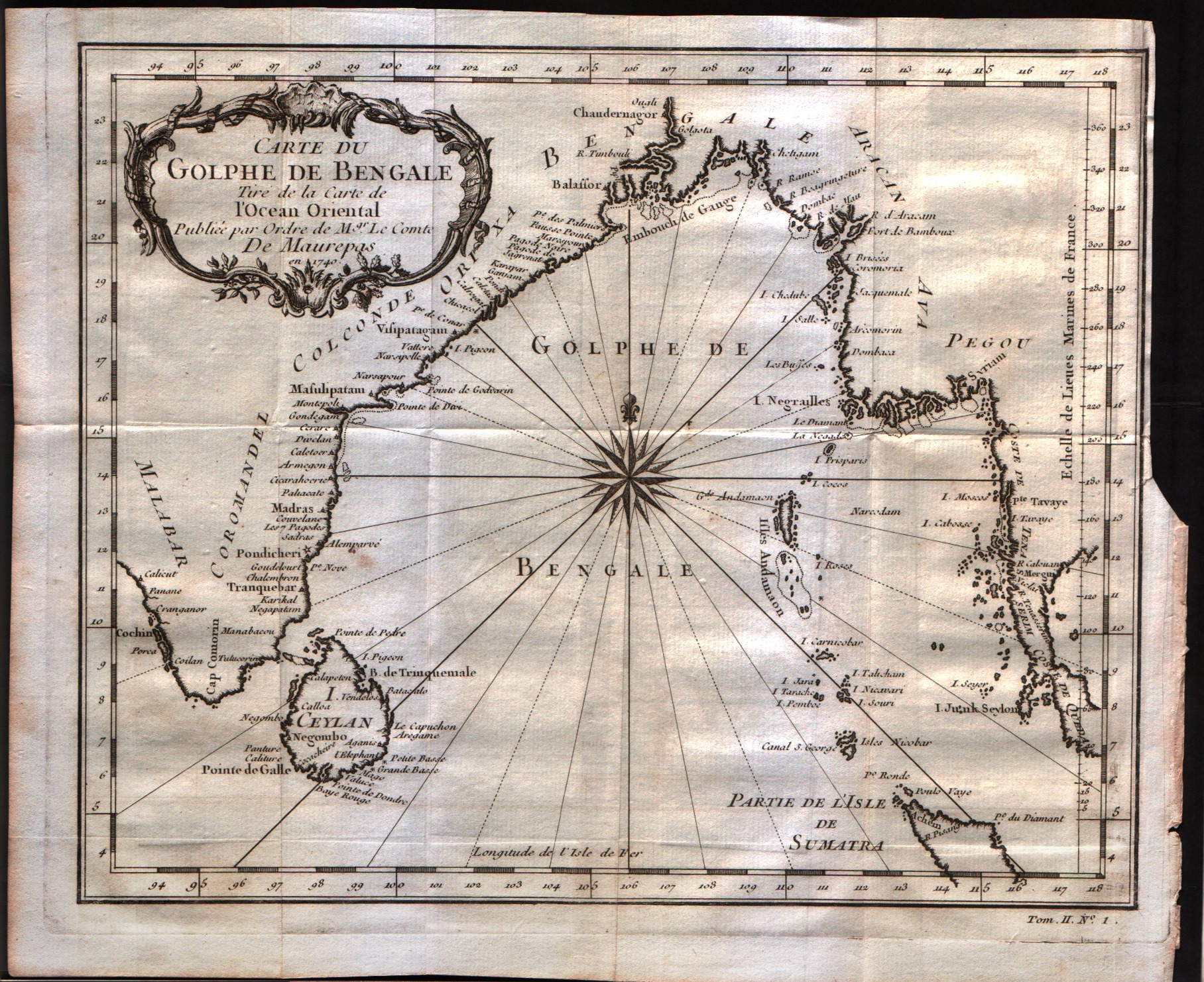
Carte du Golphe de Bengale
Author
Bellin
Location shown in map
--
Edition date
1757
Edition place
Paris
Editor
--
Atlas
Historie General des Voyages -- Prevost
Price
150 Euro
State
[mint/excellent/VERY GOOD/good/fair/mediocre/poor]
Color
Black/white
Verso
Blank
Size
Plate: cm (26.7 x 22.9) inches (10.51 x 9.02) Paper: cm (29.8 x 24.8) inches (11.73 x 9.76)
Technique
Copper engraving
Note
No particular notes for this maps
Reference
--
Wiki
Here for more info
In stock
Available
Info
info@thetreasuremaps.com
Code
#0242
×
![Carte du Golphe de Bengale by Bellin, --, 1757]()
Map title
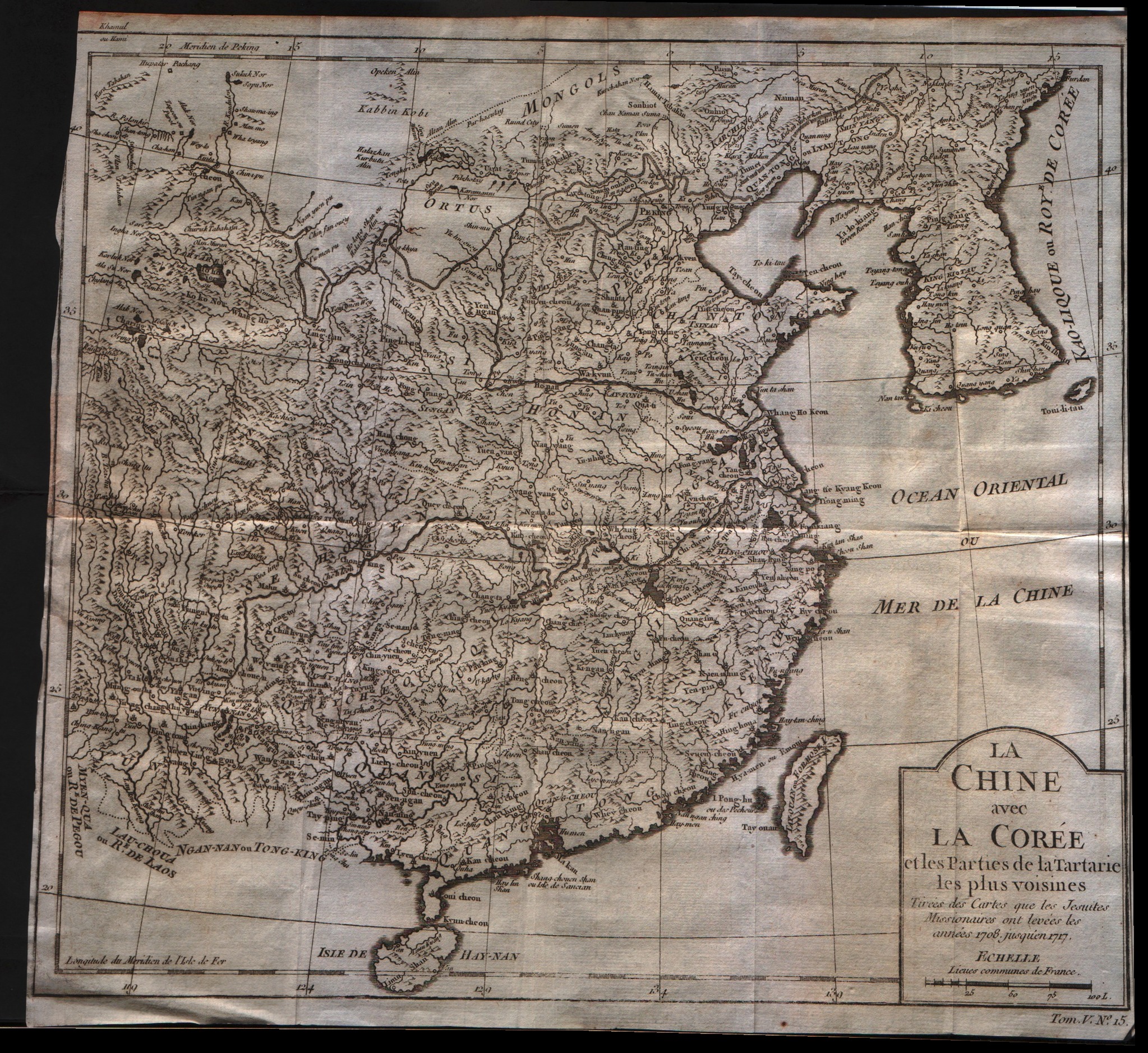
La Chine avec la Coree et les parties de la Tartarie les plus voisines
Author
Bellin
Location shown in map
China
Edition date
1757
Edition place
Paris
Editor
--
Atlas
Historie General des Voyages -- Prevost
Price
250 Euro
State
[mint/excellent/VERY GOOD/good/fair/mediocre/poor]
Color
Black/white
Verso
Blank
Size
Plate: cm (31.8 x 27.9) inches (12.52 x 10.98) Paper: cm (31.8 x 29.8) inches (12.52 x 11.73)
Technique
Copper engraving
Note
No particular notes for this maps
Reference
--
Wiki
Here for more info
In stock
Available
Info
info@thetreasuremaps.com
Code
#0243
×
![La Chine avec la Coree et les parties de la Tartarie les plus voisines by Bellin, China, 1757]()
Map title
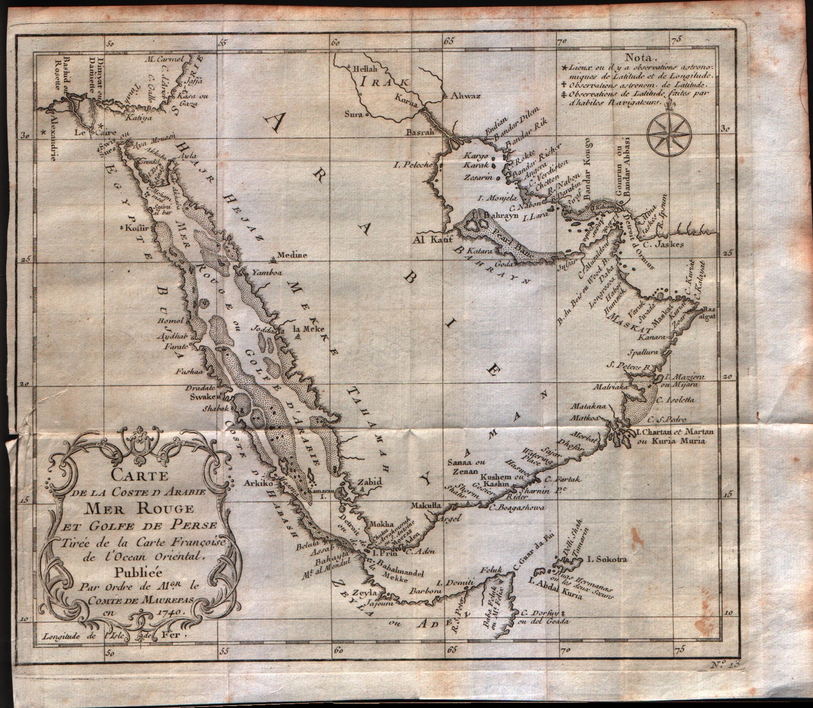
Carte de la coste d'Arabie Mer Rouge et Golfe de Perse
Author
Bellin
Location shown in map
Arabia
Edition date
1757
Edition place
Paris
Editor
--
Atlas
Historie General des Voyages -- Prevost
Price
300 Euro
State
[mint/excellent/VERY GOOD/good/fair/mediocre/poor]
Color
Black/white
Verso
Blank
Size
Plate: cm (25.4 x 21.6) inches (10 x 8.5) Paper: cm (27.9 x 24.1) inches (10.98 x 9.49)
Technique
Copper engraving
Note
No particular notes for this maps
Reference
--
Wiki
Here for more info
In stock
Available
Info
info@thetreasuremaps.com
Code
#0244
×
![Carte de la coste d'Arabie Mer Rouge et Golfe de Perse by Bellin, Arabia, 1757]()
Map title
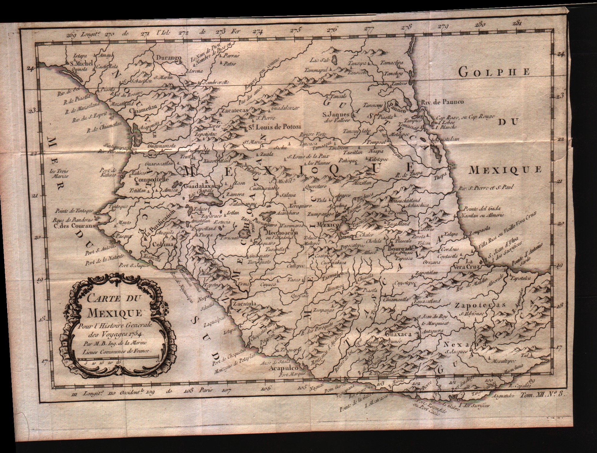
Carte du Mexique
Author
Bellin
Location shown in map
Mexico
Edition date
1757
Edition place
Paris
Editor
--
Atlas
Historie General des Voyages -- Prevost
Price
Please ask: info@thetreasuremaps.com
State
[mint/EXCELLENT/very good/good/fair/mediocre/poor]
Color
Black/white
Verso
Blank
Size
Plate: cm (29.2 x 20.3) inches (11.5 x 7.99) Paper: cm (31.8 x 22.9) inches (12.52 x 9.02)
Technique
Copper engraving
Note
No particular notes for this maps
Reference
--
Wiki
Here for more info
In stock
Available
Info
info@thetreasuremaps.com
Code
#0352
×
![Carte du Mexique by Bellin, Mexico, 1757]()
Map title
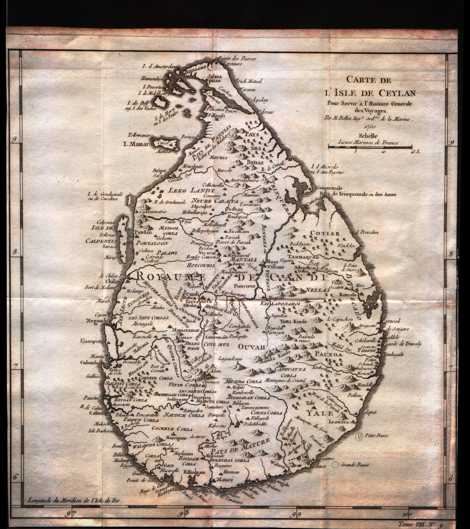
Carte de l'isle de Ceylan
Author
Bellin
Location shown in map
Ceylan islands
Edition date
1757
Edition place
Paris
Editor
--
Atlas
Historie General des Voyages -- Prevost
Price
125 Euro
State
[mint/excellent/very good/GOOD/fair/mediocre/poor]
Color
Black/white
Verso
Blank
Size
Plate: cm (24.1 x 25.4) inches (9.49 x 10) Paper: cm (24.1 x 25.4) inches (9.49 x 10)
Technique
Copper engraving
Note
No particular notes for this maps
Reference
--
Wiki
Here for more info
In stock
Available
Info
info@thetreasuremaps.com
Code
#0252
×
![Carte de l'isle de Ceylan by Bellin, Ceylan islands, 1757]()
Map title
Carte de l'isle de Ceylan
Author
Bellin
Location shown in map
Ceylan islands
Edition date
1757
Edition place
Paris
Editor
--
Atlas
Historie General des Voyages -- Prevost
Price
125 Euro
State
[mint/excellent/very good/GOOD/fair/mediocre/poor]
Color
Black/white
Verso
Blank
Size
Plate: cm (24.1 x 25.4) inches (9.49 x 10) Paper: cm (24.1 x 26.7) inches (9.49 x 10.51)
Technique
Copper engraving
Note
No particular notes for this maps
Reference
--
Wiki
Here for more info
In stock
Sold
Info
info@thetreasuremaps.com
Code
#0253
×
![Carte de l'isle de Ceylan by Bellin, Ceylan islands, 1757]()