1700-1799
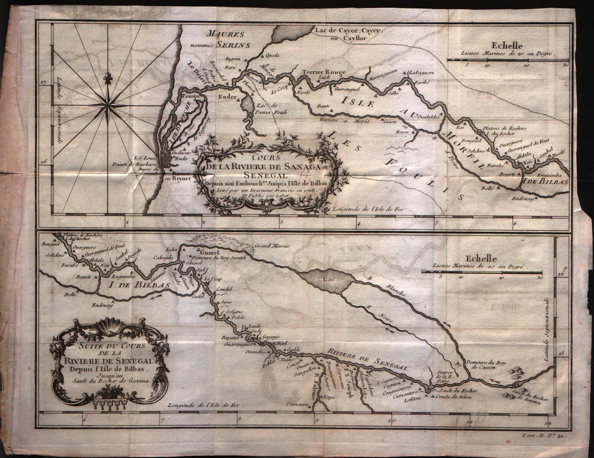
Map title
Suite du cours de la diviere de Senegal
Author
Bellin
Location shown in map
Comore islands
Edition date
1757
Edition place
Paris
Editor
--
Atlas
Historie General des Voyages -- Prevost
Price
Please ask: info@thetreasuremaps.com
State
[mint/excellent/VERY GOOD/good/fair/mediocre/poor]
Color
Black/white
Verso
Blank
Size
Plate: cm (27.9 x 22.9) inches (10.98 x 9.02) Paper: cm (31.8 x 24.1) inches (12.52 x 9.49)
Technique
Copper engraving
Note
No particular notes for this maps
Reference
--
Wiki
Here for more info
In stock
Available
Info
info@thetreasuremaps.com
Code
#0311
×
![Suite du cours de la diviere de Senegal by Bellin, Comore islands, 1757]()
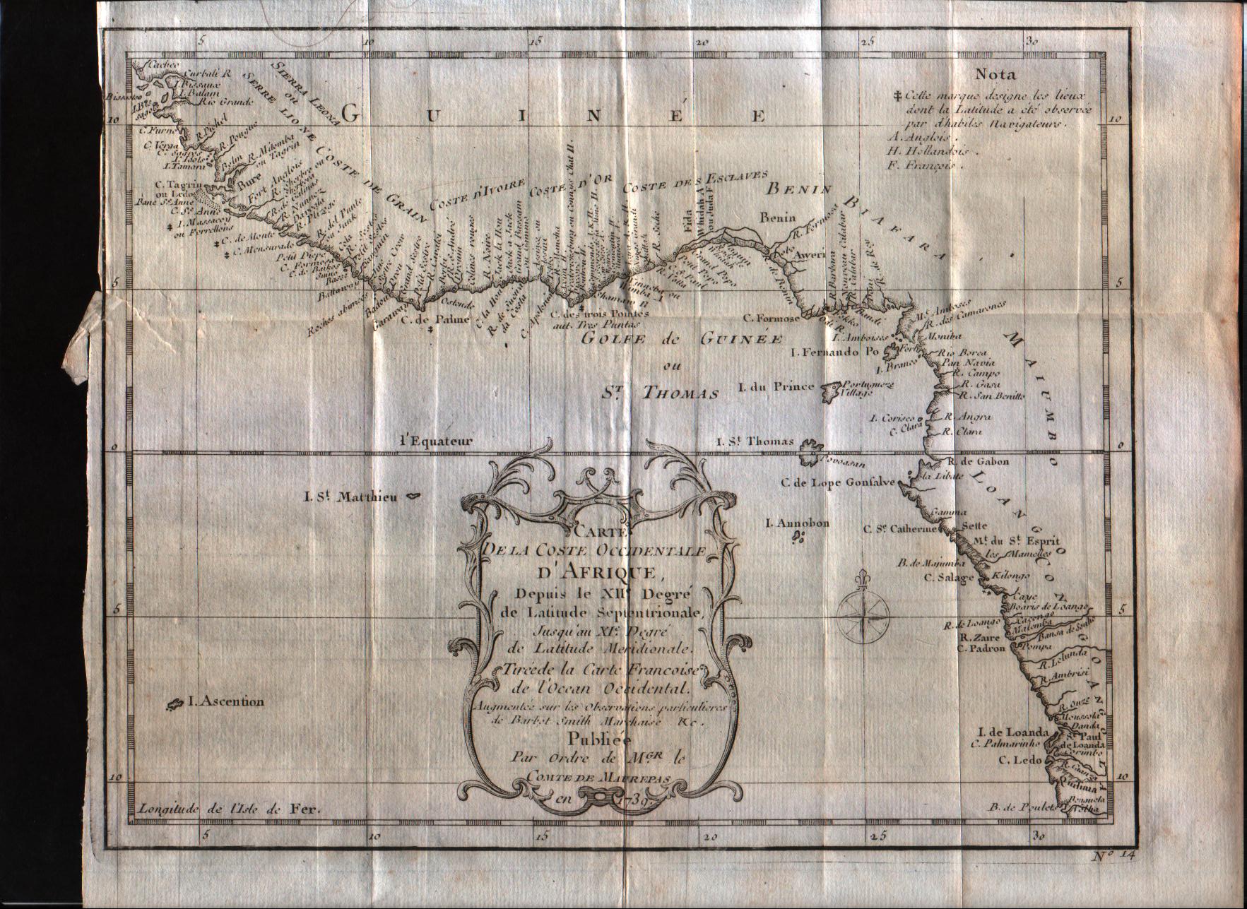
Map title
Carte de la coste Occidentale d'Afrique Depuis le XII degree de latitude Septentrionale
Author
Bellin
Location shown in map
West Afrique
Edition date
1757
Edition place
Paris
Editor
--
Atlas
Historie General des Voyages -- Prevost
Price
100 Euro
State
[mint/excellent/VERY GOOD/good/fair/mediocre/poor]
Color
Black/white
Verso
Blank
Size
Plate: cm (25.4 x 20.3) inches (10 x 7.99) Paper: cm (27.9 x 22.9) inches (10.98 x 9.02)
Technique
Copper engraving
Note
No particular notes for this maps
Reference
--
Wiki
Here for more info
In stock
Available
Info
info@thetreasuremaps.com
Code
#0312
×
![Carte de la coste Occidentale d'Afrique Depuis le XII degree de latitude Septentrionale by Bellin, West Afrique, 1757]()
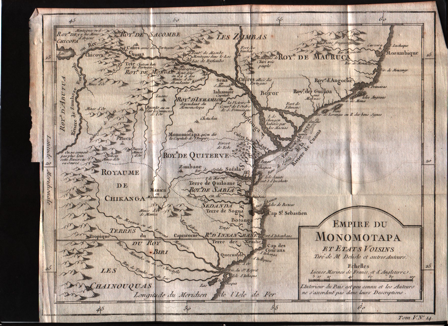
Map title
Empire du Monomotapa et etas voisins
Author
Bellin
Location shown in map
--
Edition date
1757
Edition place
Paris
Editor
--
Atlas
Historie General des Voyages -- Prevost
Price
Please ask: info@thetreasuremaps.com
State
[mint/excellent/VERY GOOD/good/fair/mediocre/poor]
Color
Black/white
Verso
Blank
Size
Plate: cm (25.4 x 20.3) inches (10 x 7.99) Paper: cm (27.9 x 21.6) inches (10.98 x 8.5)
Technique
Copper engraving
Note
No particular notes for this maps
Reference
--
Wiki
Here for more info
In stock
Available
Info
info@thetreasuremaps.com
Code
#0313
×
![Empire du Monomotapa et etas voisins by Bellin, --, 1757]()
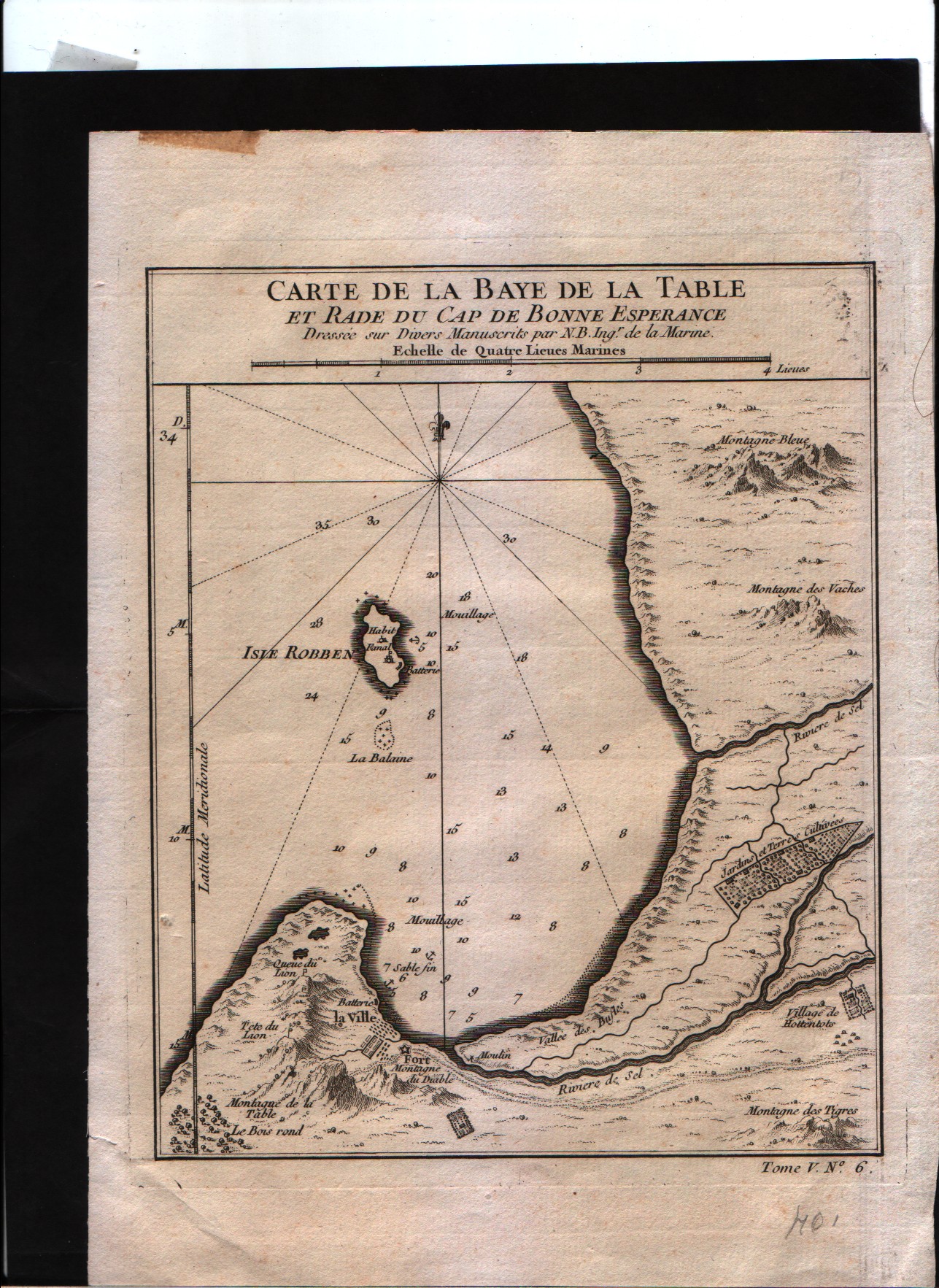
Map title
Carte de la baye de la table et rade du Cap de Bonne Esperance
Author
Bellin
Location shown in map
--
Edition date
1757
Edition place
Paris
Editor
--
Atlas
Historie General des Voyages -- Prevost
Price
Please ask: info@thetreasuremaps.com
State
[mint/excellent/VERY GOOD/good/fair/mediocre/poor]
Color
Black/white
Verso
Blank
Size
Plate: cm (16.5 x 21.6) inches (6.5 x 8.5) Paper: cm (17.8 x 22.9) inches (7.01 x 9.02)
Technique
Copper engraving
Note
No particular notes for this maps
Reference
--
Wiki
Here for more info
In stock
Sold
Info
info@thetreasuremaps.com
Code
#0314
×
![Carte de la baye de la table et rade du Cap de Bonne Esperance by Bellin, --, 1757]()

Map title
Plan du Fort et de la Ville du Cap de Bonne Esperance
Author
Bellin
Location shown in map
--
Edition date
1757
Edition place
Paris
Editor
--
Atlas
Historie General des Voyages -- Prevost
Price
Please ask: info@thetreasuremaps.com
State
[mint/excellent/VERY GOOD/good/fair/mediocre/poor]
Color
Black/white
Verso
Blank
Size
Plate: cm (26.7 x 21.6) inches (10.51 x 8.5) Paper: cm (27.9 x 22.9) inches (10.98 x 9.02)
Technique
Copper engraving
Note
No particular notes for this maps
Reference
--
Wiki
Here for more info
In stock
Sold
Info
info@thetreasuremaps.com
Code
#0315
×
![Plan du Fort et de la Ville du Cap de Bonne Esperance by Bellin, --, 1757]()
Map title
Plan du Fort et de la Ville du Cap de Bonne Esperance
Author
Bellin
Location shown in map
--
Edition date
1757
Edition place
Paris
Editor
--
Atlas
Historie General des Voyages -- Prevost
Price
Please ask: info@thetreasuremaps.com
State
[mint/excellent/VERY GOOD/good/fair/mediocre/poor]
Color
Black/white
Verso
Blank
Size
Plate: cm (26.7 x 21.6) inches (10.51 x 8.5) Paper: cm (27.9 x 22.9) inches (10.98 x 9.02)
Technique
Copper engraving
Note
No particular notes for this maps
Reference
--
Wiki
Here for more info
In stock
Sold
Info
info@thetreasuremaps.com
Code
#0316
×
![Plan du Fort et de la Ville du Cap de Bonne Esperance by Bellin, --, 1757]()
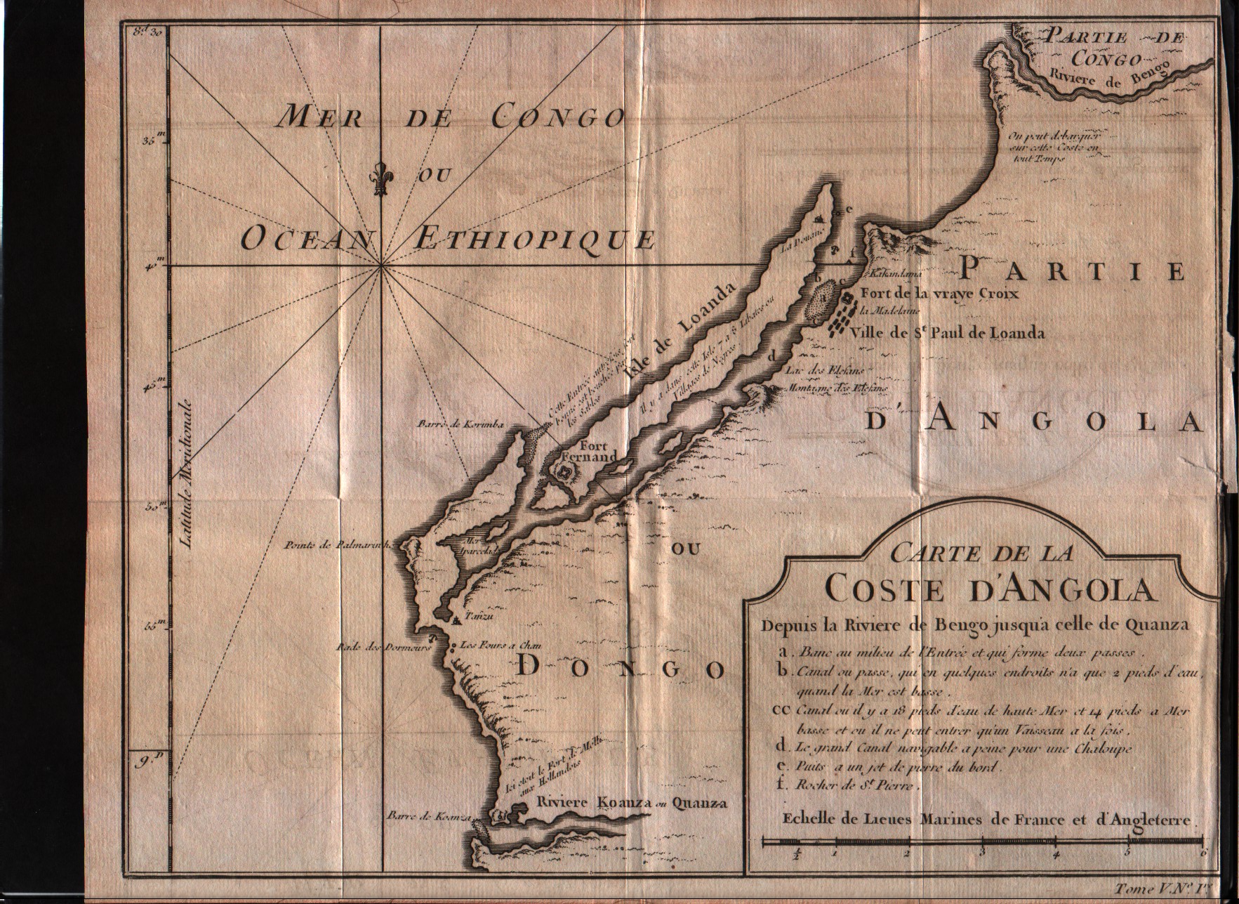
Map title
Carte de la Coste d'Angola
Author
Bellin
Location shown in map
Angola
Edition date
1757
Edition place
Paris
Editor
--
Atlas
Historie General des Voyages -- Prevost
Price
Please ask: info@thetreasuremaps.com
State
[mint/excellent/VERY GOOD/good/fair/mediocre/poor]
Color
Black/white
Verso
Blank
Size
Plate: cm (26.7 x 20.3) inches (10.51 x 7.99) Paper: cm (27.9 x 22.9) inches (10.98 x 9.02)
Technique
Copper engraving
Note
No particular notes for this maps
Reference
--
Wiki
Here for more info
In stock
Available
Info
info@thetreasuremaps.com
Code
#0317
×
![Carte de la Coste d'Angola by Bellin, Angola, 1757]()
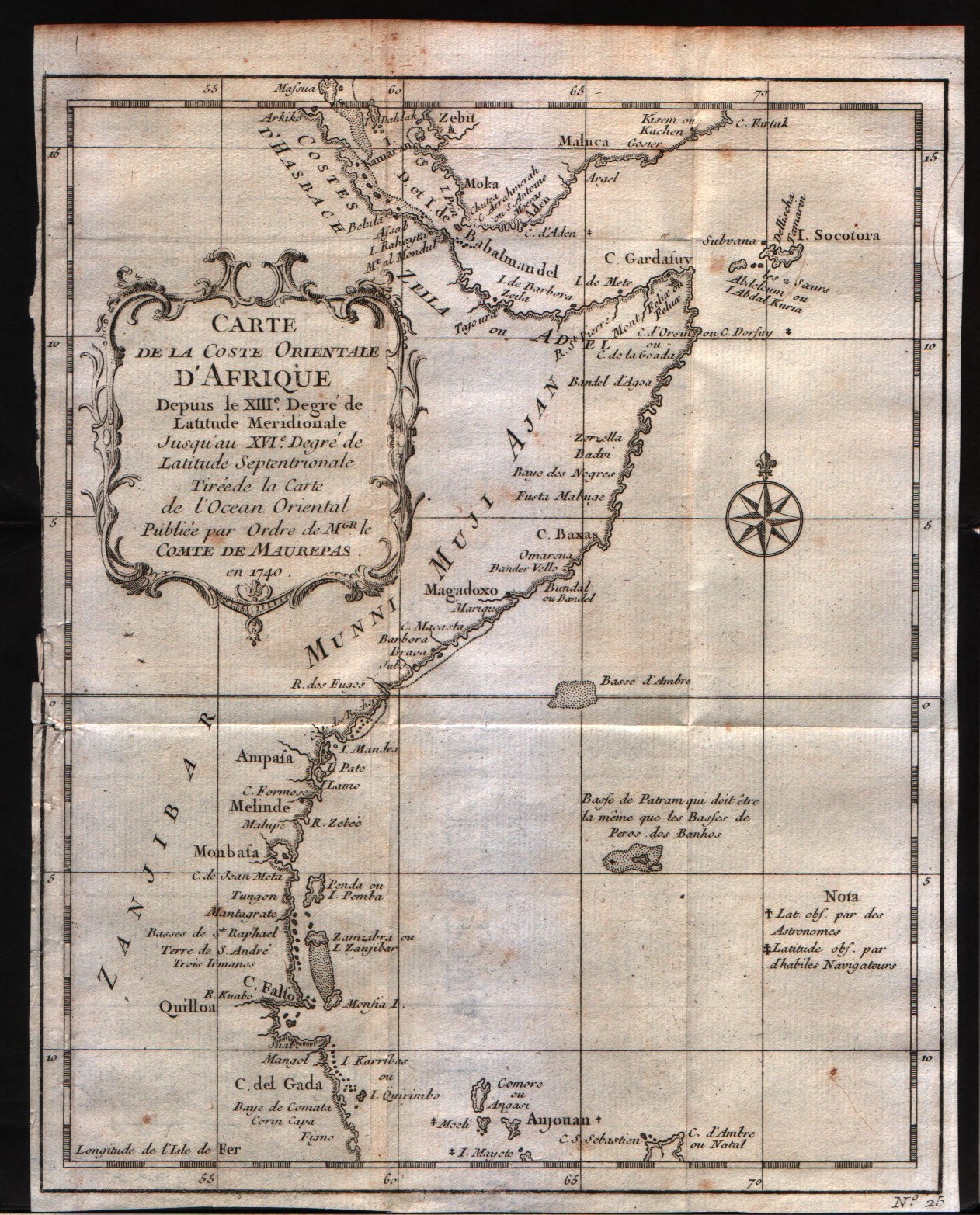
Map title
Carte de la Coste Orientale d'Afrique depuis le XIII degre de latitudine
Author
Bellin
Location shown in map
East Africa
Edition date
1757
Edition place
Paris
Editor
--
Atlas
Historie General des Voyages -- Prevost
Price
100 Euro
State
[mint/excellent/VERY GOOD/good/fair/mediocre/poor]
Color
Black/white
Verso
Blank
Size
Plate: cm (20.3 x 24.1) inches (7.99 x 9.49) Paper: cm (20.3 x 25.4) inches (7.99 x 10)
Technique
Copper engraving
Note
No particular notes for this maps
Reference
--
Wiki
Here for more info
In stock
Available
Info
info@thetreasuremaps.com
Code
#0318
×
![Carte de la Coste Orientale d'Afrique depuis le XIII degre de latitudine by Bellin, East Africa, 1757]()
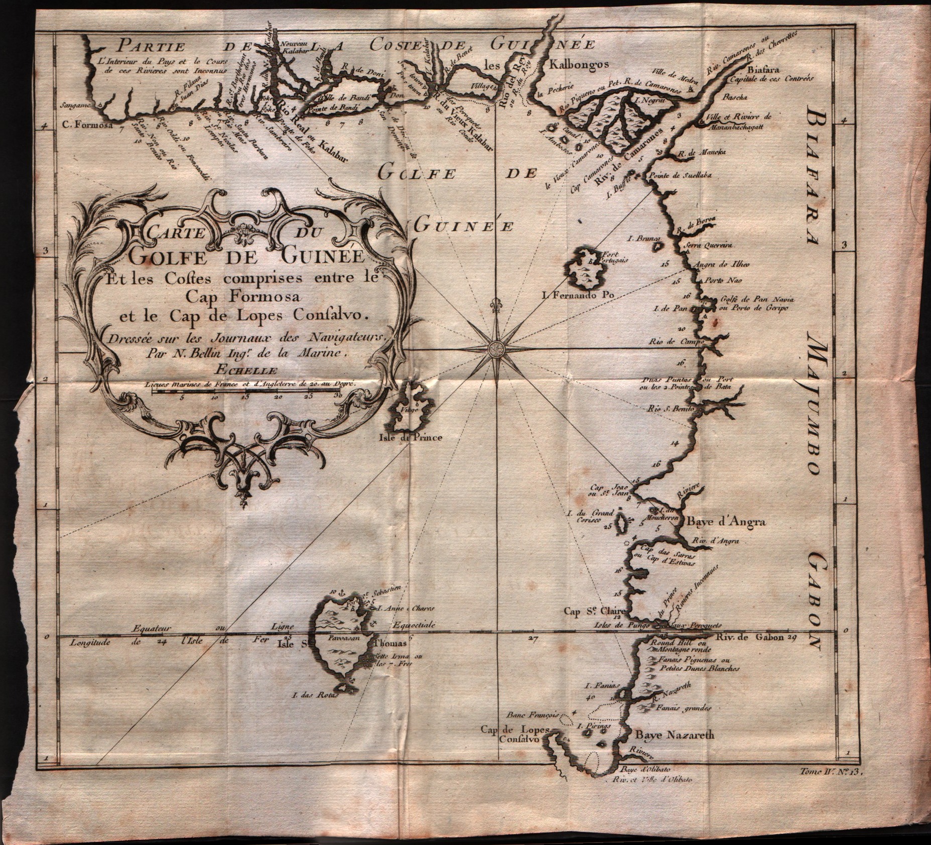
Map title
Carte du Golfe de Guinee et les costes comprises entre le Cap Formosa ...
Author
Bellin
Location shown in map
Gulf of Guinee
Edition date
1757
Edition place
Paris
Editor
--
Atlas
Historie General des Voyages -- Prevost
Price
Please ask: info@thetreasuremaps.com
State
[mint/excellent/VERY GOOD/good/fair/mediocre/poor]
Color
Black/white
Verso
Blank
Size
Plate: cm (27.9 x 25.4) inches (10.98 x 10) Paper: cm (30.5 x 27.9) inches (12.01 x 10.98)
Technique
Copper engraving
Note
No particular notes for this maps
Reference
--
Wiki
Here for more info
In stock
Available
Info
info@thetreasuremaps.com
Code
#0319
×
![Carte du Golfe de Guinee et les costes comprises entre le Cap Formosa ... by Bellin, Gulf of Guinee, 1757]()
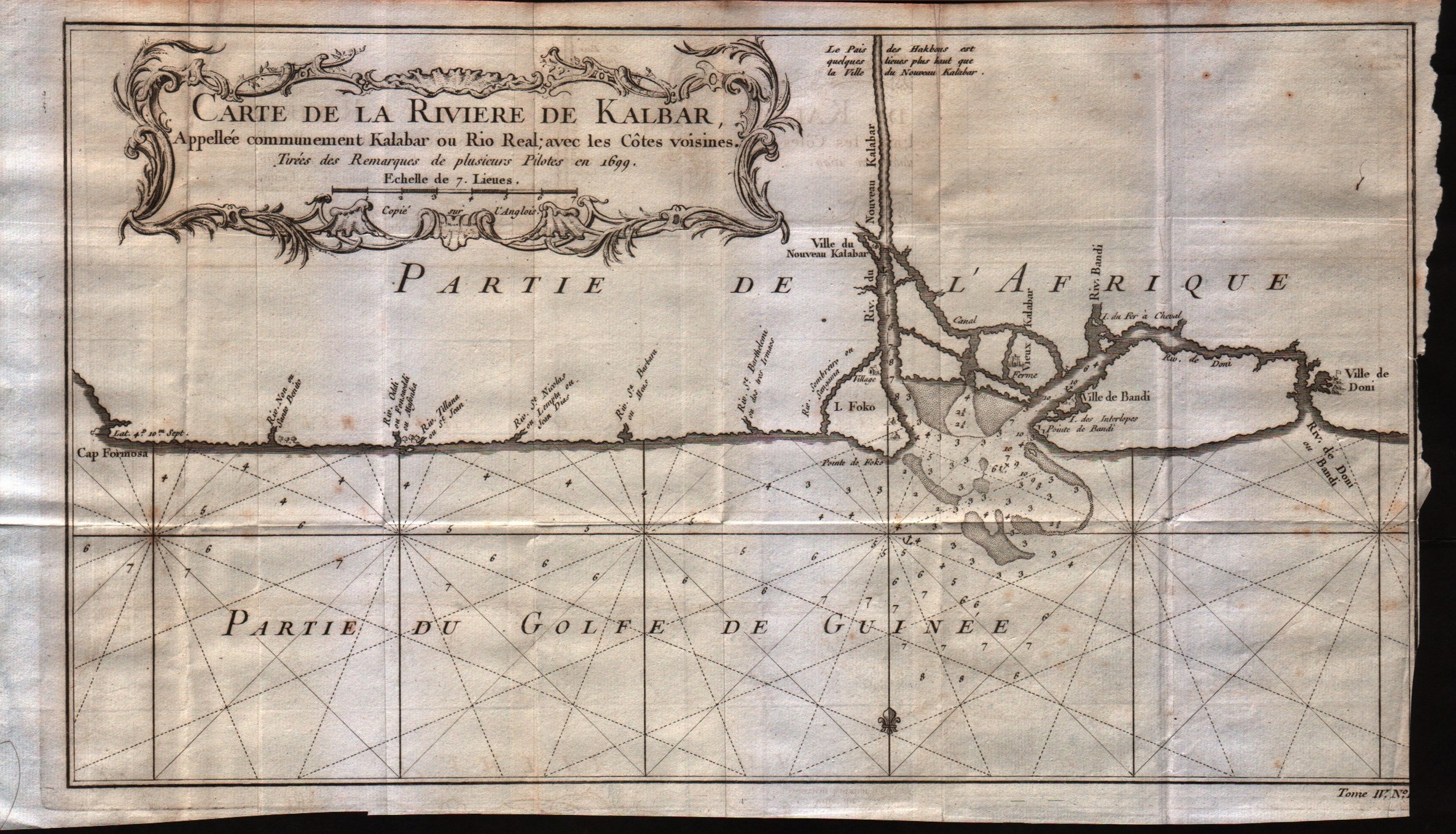
Map title
Carte de la riviere de Kalbar
Author
Bellin
Location shown in map
--
Edition date
1757
Edition place
Paris
Editor
--
Atlas
Historie General des Voyages -- Prevost
Price
Please ask: info@thetreasuremaps.com
State
[mint/excellent/VERY GOOD/good/fair/mediocre/poor]
Color
Black/white
Verso
Blank
Size
Plate: cm (35.6 x 20.3) inches (14.02 x 7.99) Paper: cm (38.1 x 22.9) inches (15 x 9.02)
Technique
Copper engraving
Note
No particular notes for this maps
Reference
--
Wiki
Here for more info
In stock
Available
Info
info@thetreasuremaps.com
Code
#0320
×
![Carte de la riviere de Kalbar by Bellin, --, 1757]()
Map title
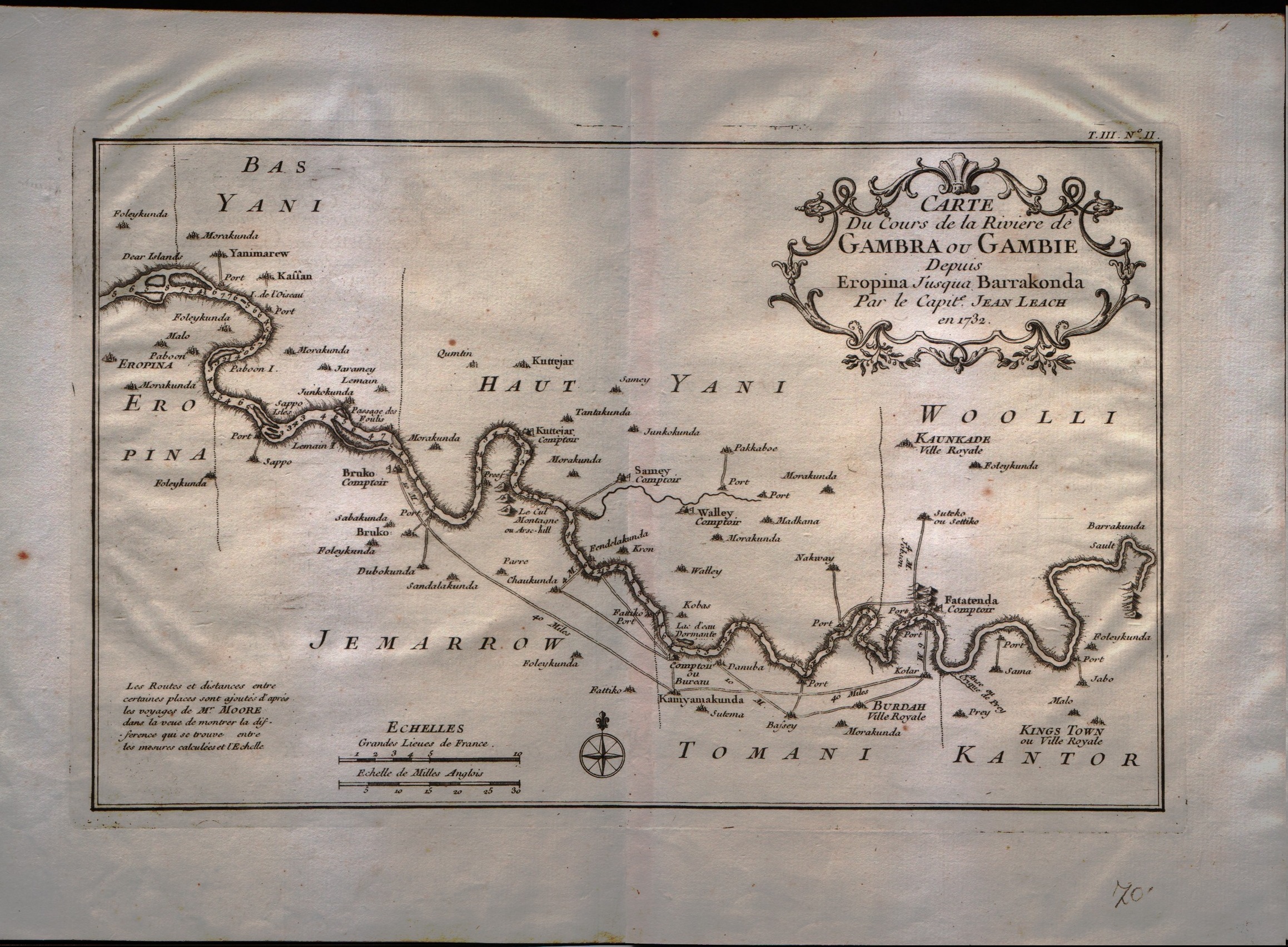
Carte du cours de la riviere de Gambia ou Gambie depuis ...
Author
Bellin
Location shown in map
Gambia river
Edition date
1757
Edition place
Paris
Editor
--
Atlas
Historie General des Voyages -- Prevost
Price
Please ask: info@thetreasuremaps.com
State
[mint/excellent/VERY GOOD/good/fair/mediocre/poor]
Color
Black/white
Verso
Blank
Size
Plate: cm (31.8 x 20.3) inches (12.52 x 7.99) Paper: cm (35.6 x 22.9) inches (14.02 x 9.02)
Technique
Copper engraving
Note
No particular notes for this maps
Reference
--
Wiki
Here for more info
In stock
Available
Info
info@thetreasuremaps.com
Code
#0321
×
![Carte du cours de la riviere de Gambia ou Gambie depuis ... by Bellin, Gambia river, 1757]()
Map title
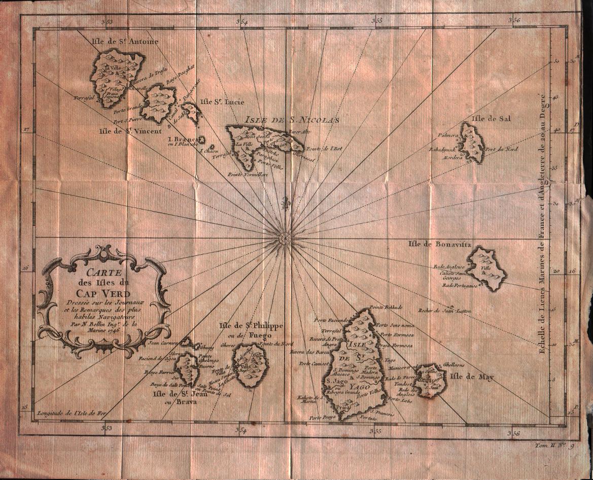
Carte des isles du Cap Verd
Author
Bellin
Location shown in map
Cape Verde island
Edition date
1757
Edition place
Paris
Editor
--
Atlas
Historie General des Voyages -- Prevost
Price
100 Euro
State
[mint/excellent/VERY GOOD/good/fair/mediocre/poor]
Color
Black/white
Verso
Blank
Size
Plate: cm (27.9 x 21.6) inches (10.98 x 8.5) Paper: cm (30.5 x 25.4) inches (12.01 x 10)
Technique
Copper engraving
Note
No particular notes for this maps
Reference
--
Wiki
Here for more info
In stock
Available
Info
info@thetreasuremaps.com
Code
#0322
×
![Carte des isles du Cap Verd by Bellin, Cape Verde island, 1757]()
Map title
Essay D'Une Catre Reduite Contenant Les Parties Connues Du Globe Terrestre
Author
Bellin
Location shown in map
World
Edition date
1757
Edition place
Paris
Editor
--
Atlas
Historie General DesVoyages
Price
900 Euro
State
[mint/EXCELLENT/very good/good/fair/mediocre/poor]
Color
Black/white
Verso
Blank
Size
Plate: cm ( x ) inches (0 x 0) Paper: cm ( x ) inches (0 x 0)
Technique
Copper engraving
Note
Four sheets
Reference
--
Wiki
Here for more info
In stock
Available
Info
info@thetreasuremaps.com
Code
#0330
×
![Essay D'Une Catre Reduite Contenant Les Parties Connues Du Globe Terrestre by Bellin, World, 1757]()
Map title
Carte des environs de la ville de Mexico
Author
Bellin
Location shown in map
Map of Mexico city
Edition date
1757
Edition place
Paris
Editor
--
Atlas
Historie General des Voyages -- Prevost
Price
Please ask: info@thetreasuremaps.com
State
[mint/EXCELLENT/very good/good/fair/mediocre/poor]
Color
Black/white
Verso
Blank
Size
Plate: cm (17.8 x 22.9) inches (7.01 x 9.02) Paper: cm (16.5 x 20.3) inches (6.5 x 7.99)
Technique
Copper engraving
Note
No particular notes for this maps
Reference
--
Wiki
Here for more info
In stock
Sold
Info
info@thetreasuremaps.com
Code
#0346
×
![Carte des environs de la ville de Mexico by Bellin, Map of Mexico city, 1757]()
Map title
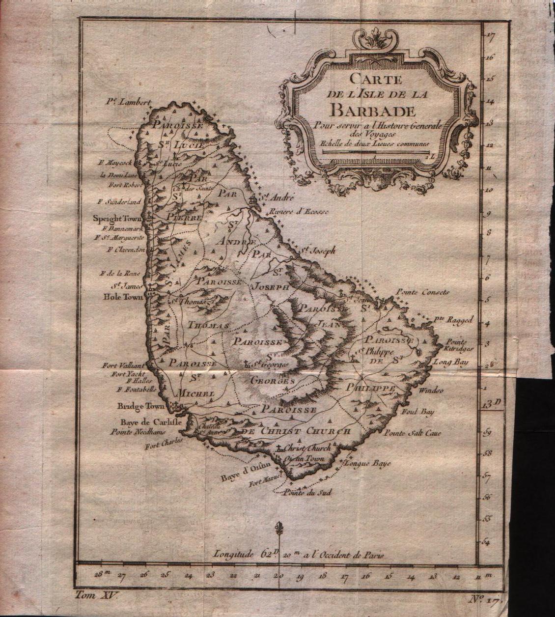
Carte de l'isle de la Barbade
Author
Bellin
Location shown in map
Barbados
Edition date
1757
Edition place
Paris
Editor
--
Atlas
Historie General des Voyages -- Prevost
Price
150 Euro
State
[mint/EXCELLENT/very good/good/fair/mediocre/poor]
Color
Black/white
Verso
Blank
Size
Plate: cm (15.2 x 20.3) inches (5.98 x 7.99) Paper: cm (17.8 x 22.9) inches (7.01 x 9.02)
Technique
Copper engraving
Note
No particular notes for this maps
Reference
--
Wiki
Here for more info
In stock
Available
Info
info@thetreasuremaps.com
Code
#0347
×
![Carte de l'isle de la Barbade by Bellin, Barbados, 1757]()
Map title
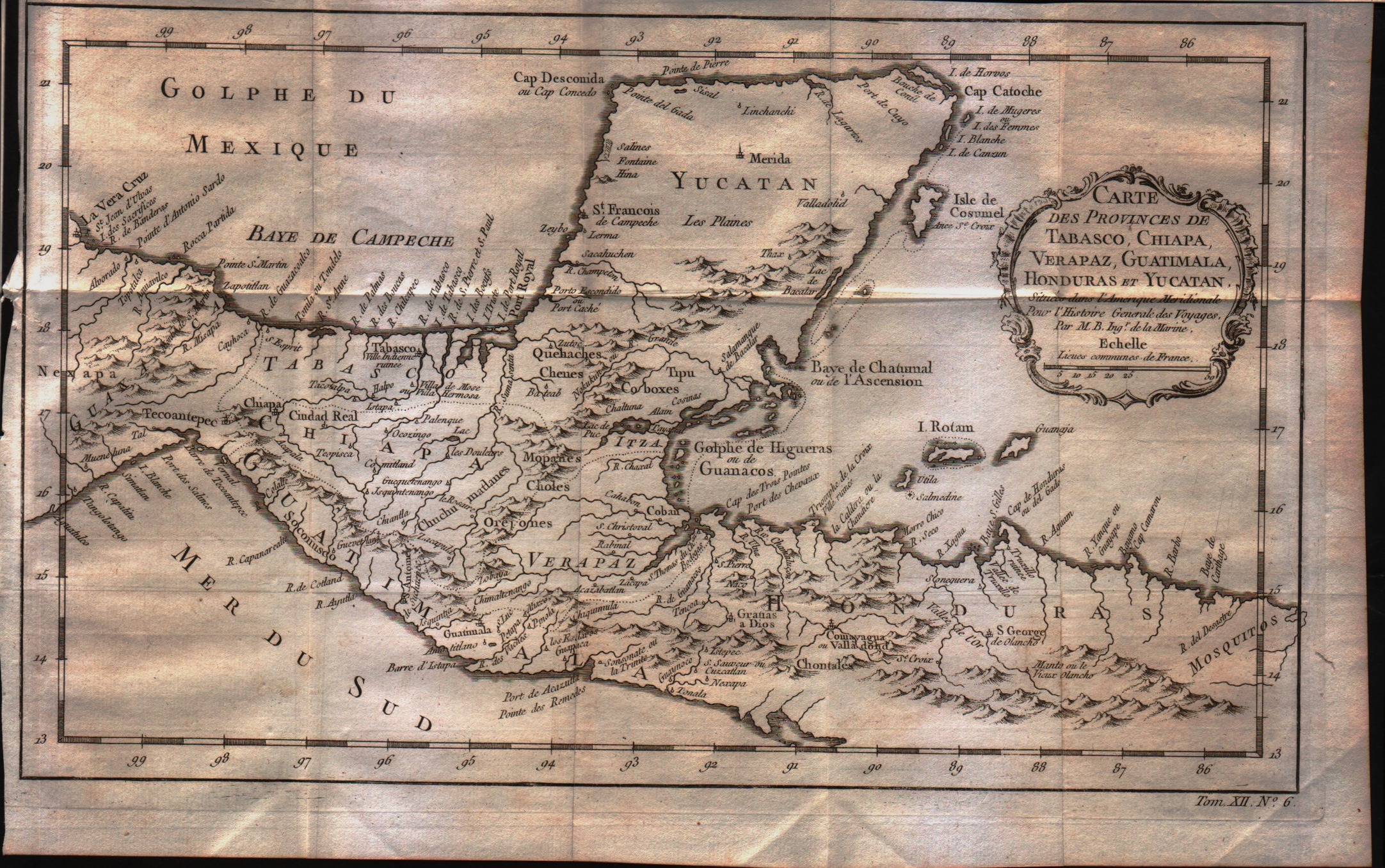
Carte des Provinces de Tabasco, Chiapa, Verapaz, Guatimala, Honduras et Yucatan
Author
Bellin
Location shown in map
--
Edition date
1757
Edition place
Paris
Editor
--
Atlas
Historie General des Voyages -- Prevost
Price
75 Euro
State
[mint/EXCELLENT/very good/good/fair/mediocre/poor]
Color
Black/white
Verso
Blank
Size
Plate: cm (33 x 20.3) inches (12.99 x 7.99) Paper: cm (35.6 x 22.9) inches (14.02 x 9.02)
Technique
Copper engraving
Note
No particular notes for this maps
Reference
--
Wiki
Here for more info
In stock
Available
Info
info@thetreasuremaps.com
Code
#0348
×
![Carte des Provinces de Tabasco, Chiapa, Verapaz, Guatimala, Honduras et Yucatan by Bellin, --, 1757]()
Map title
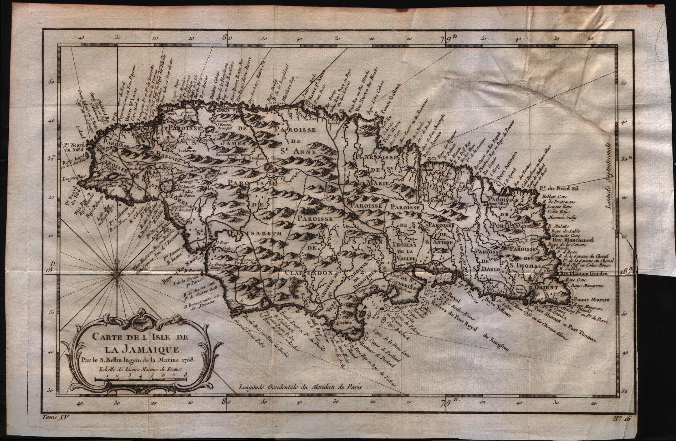
Carte de lisle de la Jamaique
Author
Bellin
Location shown in map
Jamaica
Edition date
1757
Edition place
Paris
Editor
--
Atlas
Historie General des Voyages -- Prevost
Price
150 Euro
State
[mint/excellent/very good/good/fair/MEDIOCRE/poor]
Color
Black/white
Verso
Blank
Size
Plate: cm (15.2 x 20.3) inches (5.98 x 7.99) Paper: cm (30.5 x 20.3) inches (12.01 x 7.99)
Technique
Copper engraving
Note
No particular notes for this maps
Reference
--
Wiki
Here for more info
In stock
Available
Info
info@thetreasuremaps.com
Code
#0349
×
![Carte de lisle de la Jamaique by Bellin, Jamaica, 1757]()
Map title
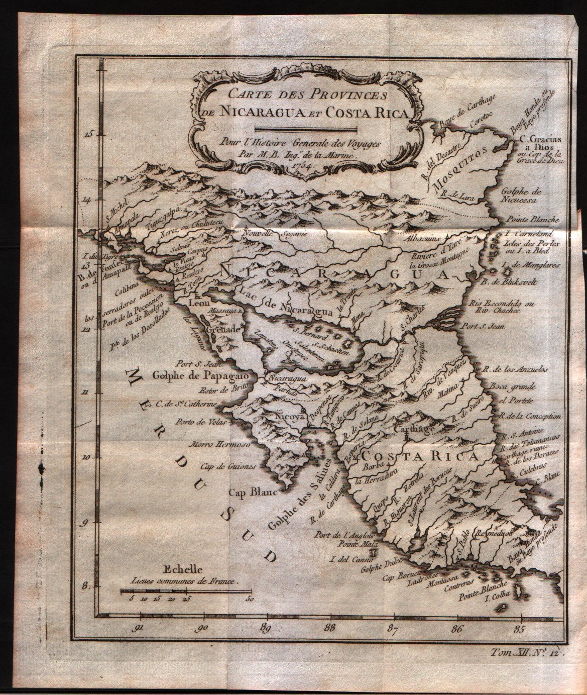
Carte des provinces de Nicaragua et Costa Rica
Author
Bellin
Location shown in map
Nicaragua and Costa Rica
Edition date
1757
Edition place
Paris
Editor
--
Atlas
Historie General des Voyages -- Prevost
Price
Please ask: info@thetreasuremaps.com
State
[mint/EXCELLENT/very good/good/fair/mediocre/poor]
Color
Black/white
Verso
Blank
Size
Plate: cm (16.5 x 20.3) inches (6.5 x 7.99) Paper: cm (19 x 22.9) inches (7.48 x 9.02)
Technique
Copper engraving
Note
No particular notes for this maps
Reference
--
Wiki
Here for more info
In stock
Available
Info
info@thetreasuremaps.com
Code
#0350
×
![Carte des provinces de Nicaragua et Costa Rica by Bellin, Nicaragua and Costa Rica, 1757]()
Map title
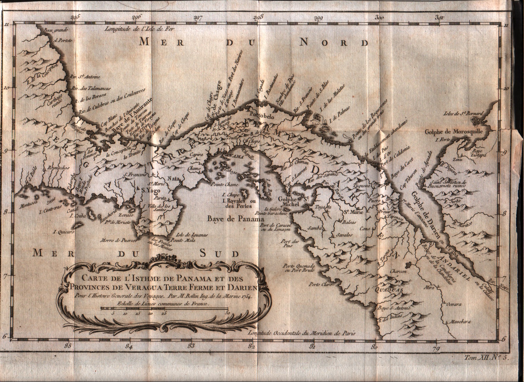
Carte de l'isthme de Panama et des des provinces de Veragua Terre Ferme et Darien
Author
Bellin
Location shown in map
Panama
Edition date
1757
Edition place
Paris
Editor
--
Atlas
Historie General des Voyages -- Prevost
Price
Please ask: info@thetreasuremaps.com
State
[mint/EXCELLENT/very good/good/fair/mediocre/poor]
Color
Black/white
Verso
Blank
Size
Plate: cm (27.9 x 20.3) inches (10.98 x 7.99) Paper: cm (31.8 x 22.9) inches (12.52 x 9.02)
Technique
Copper engraving
Note
No particular notes for this maps
Reference
--
Wiki
Here for more info
In stock
Available
Info
info@thetreasuremaps.com
Code
#0351
×
![Carte de l'isthme de Panama et des des provinces de Veragua Terre Ferme et Darien by Bellin, Panama, 1757]()
Map title
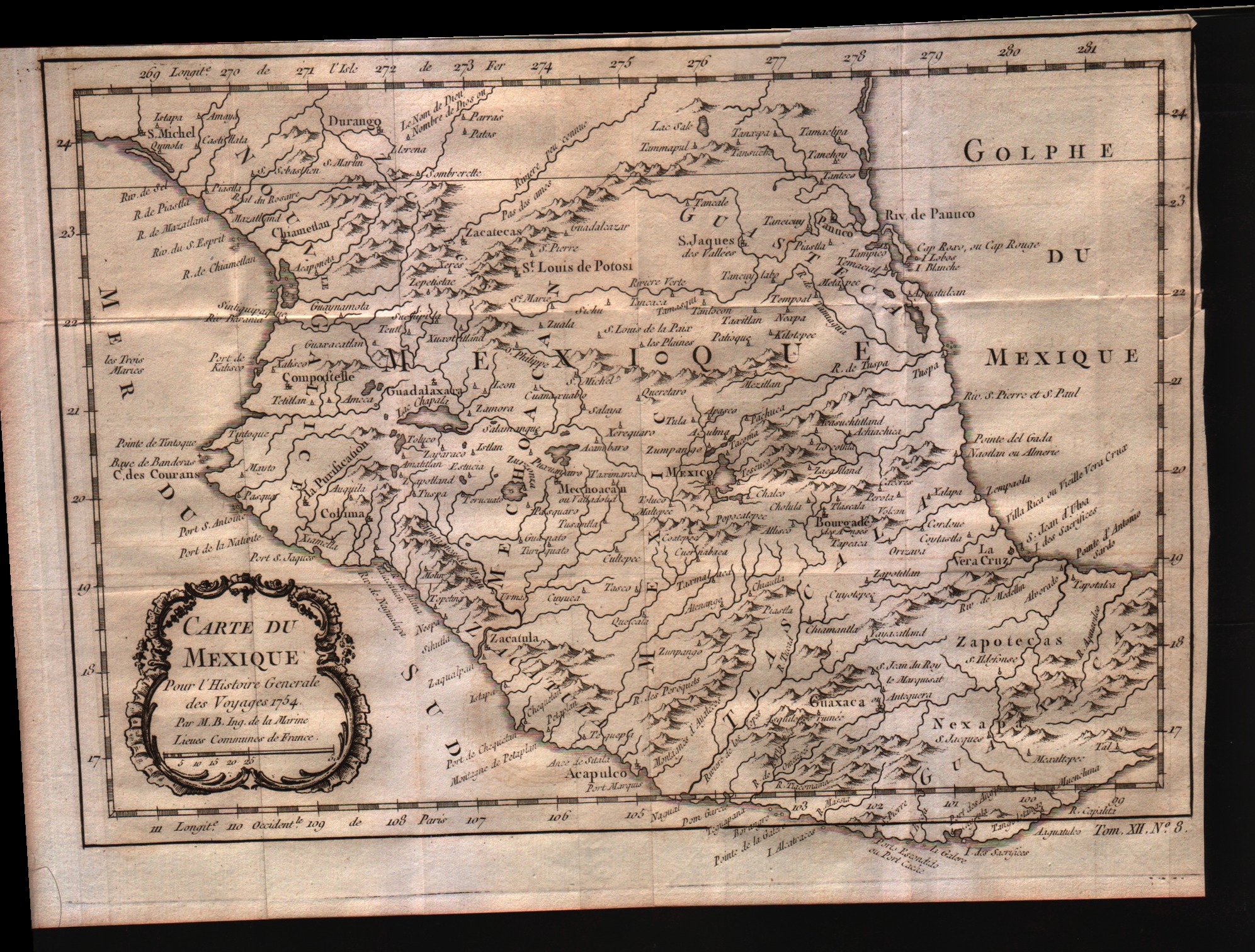
Carte du Mexique
Author
Bellin
Location shown in map
Mexico
Edition date
1757
Edition place
Paris
Editor
--
Atlas
Historie General des Voyages -- Prevost
Price
Please ask: info@thetreasuremaps.com
State
[mint/EXCELLENT/very good/good/fair/mediocre/poor]
Color
Black/white
Verso
Blank
Size
Plate: cm (29.2 x 20.3) inches (11.5 x 7.99) Paper: cm (31.8 x 22.9) inches (12.52 x 9.02)
Technique
Copper engraving
Note
No particular notes for this maps
Reference
--
Wiki
Here for more info
In stock
Available
Info
info@thetreasuremaps.com
Code
#0352
×
![Carte du Mexique by Bellin, Mexico, 1757]()