1700-1799
Map title
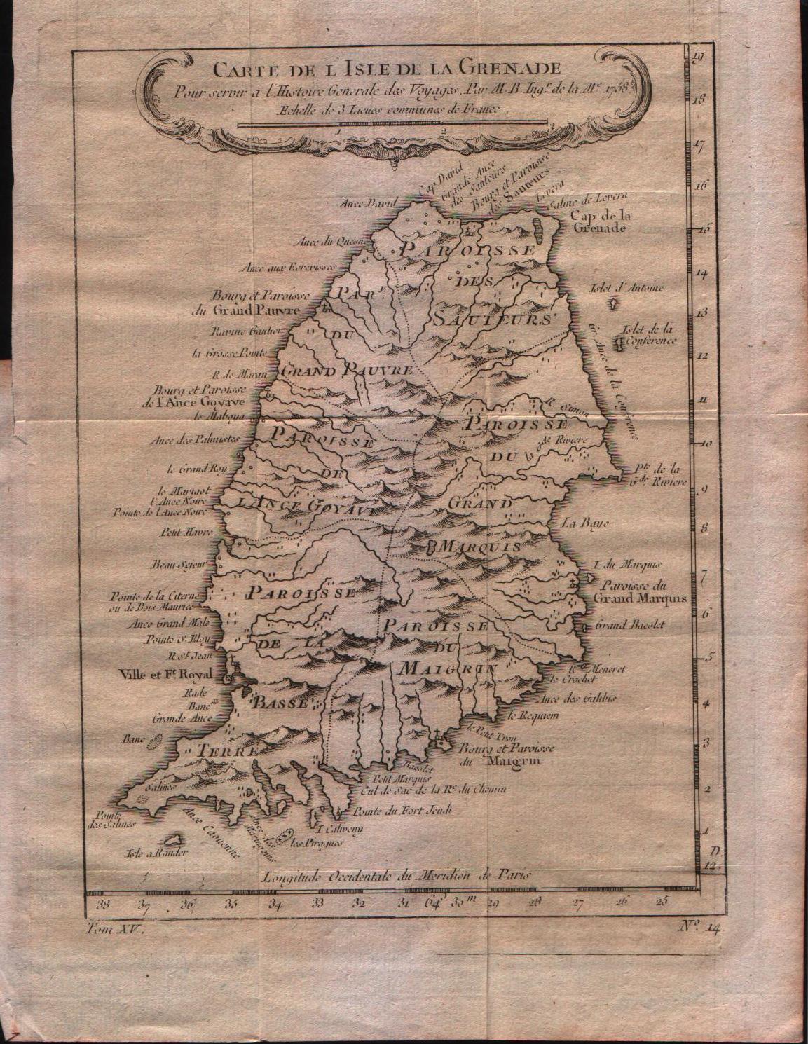
Carte de l'isle de la Grenade
Author
Bellin
Location shown in map
Grenada
Edition date
1757
Edition place
Paris
Editor
--
Atlas
Historie General des Voyages -- Prevost
Price
150 Euro
State
[mint/EXCELLENT/very good/good/fair/mediocre/poor]
Color
Black/white
Verso
Blank
Size
Plate: cm (15.2 x 21.6) inches (5.98 x 8.5) Paper: cm (20.3 x 25.4) inches (7.99 x 10)
Technique
Copper engraving
Note
No particular notes for this maps
Reference
--
Wiki
Here for more info
In stock
Available
Info
info@thetreasuremaps.com
Code
#0353
×
![Carte de l'isle de la Grenade by Bellin, Grenada, 1757]()
Map title
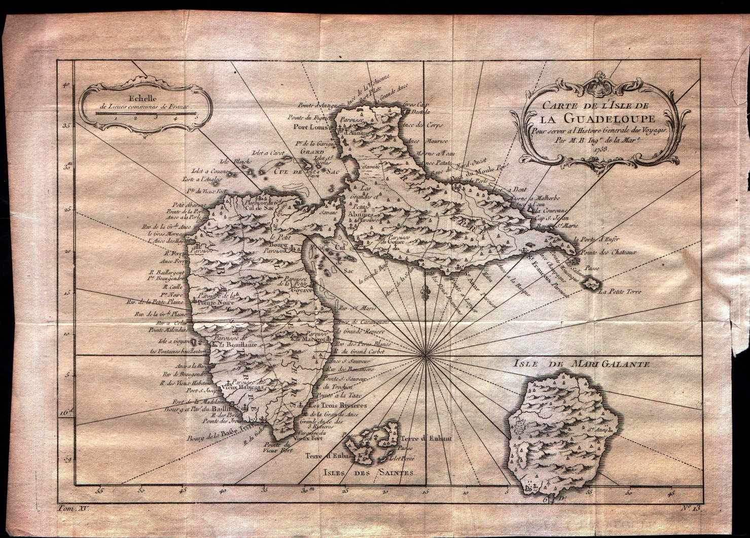
Carte de l'isle de la Guadeloupe
Author
Bellin
Location shown in map
Guadeloupe
Edition date
1757
Edition place
Paris
Editor
--
Atlas
Historie General des Voyages -- Prevost
Price
150 Euro
State
[mint/EXCELLENT/very good/good/fair/mediocre/poor]
Color
Black/white
Verso
Blank
Size
Plate: cm (30.5 x 21.6) inches (12.01 x 8.5) Paper: cm (34.3 x 25.4) inches (13.5 x 10)
Technique
Copper engraving
Note
No particular notes for this maps
Reference
--
Wiki
Here for more info
In stock
Available
Info
info@thetreasuremaps.com
Code
#0354
×
![Carte de l'isle de la Guadeloupe by Bellin, Guadeloupe, 1757]()
Map title
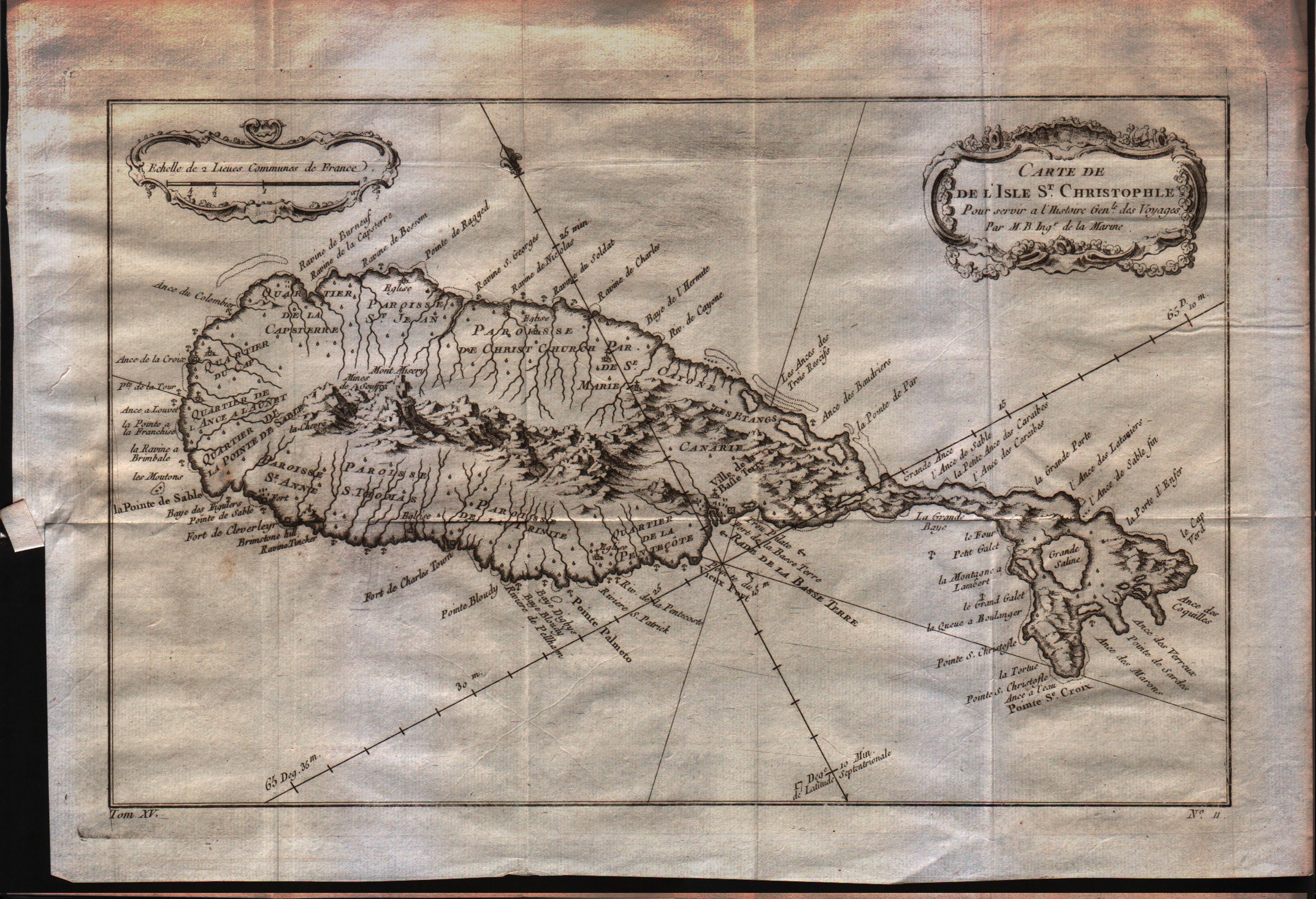
Carte de l'isle St.Christophle
Author
Bellin
Location shown in map
St.Christopher
Edition date
1757
Edition place
Paris
Editor
--
Atlas
Historie General des Voyages -- Prevost
Price
150 Euro
State
[mint/EXCELLENT/very good/good/fair/mediocre/poor]
Color
Black/white
Verso
Blank
Size
Plate: cm (30.5 x 20.3) inches (12.01 x 7.99) Paper: cm (34.3 x 24.1) inches (13.5 x 9.49)
Technique
Copper engraving
Note
No particular notes for this maps
Reference
--
Wiki
Here for more info
In stock
Available
Info
info@thetreasuremaps.com
Code
#0355
×
![Carte de l'isle St.Christophle by Bellin, St.Christopher, 1757]()
Map title
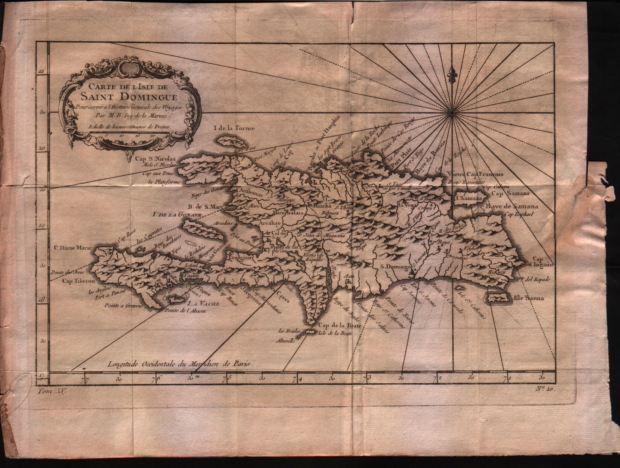
Carte de l'isle de Saint Domingue
Author
Bellin
Location shown in map
Haiti
Edition date
1757
Edition place
Paris
Editor
--
Atlas
Historie General des Voyages -- Prevost
Price
150 Euro
State
[mint/EXCELLENT/very good/good/fair/mediocre/poor]
Color
Black/white
Verso
Blank
Size
Plate: cm (27.9 x 20.3) inches (10.98 x 7.99) Paper: cm (33 x 25.4) inches (12.99 x 10)
Technique
Copper engraving
Note
No particular notes for this maps
Reference
--
Wiki
Here for more info
In stock
Available
Info
info@thetreasuremaps.com
Code
#0356
×
![Carte de l'isle de Saint Domingue by Bellin, Haiti, 1757]()
Map title
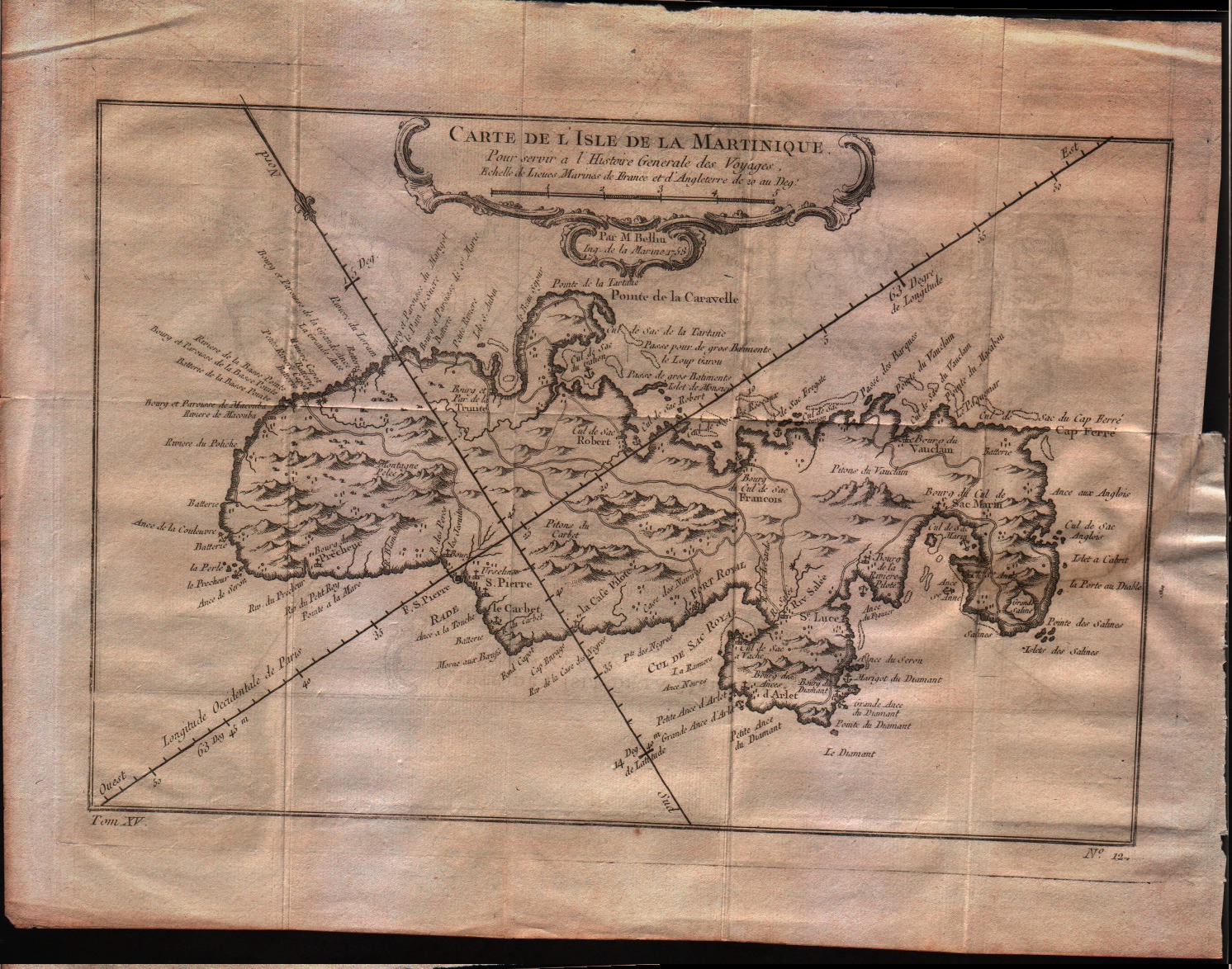
Carte de l'isle de la Martinique
Author
Bellin
Location shown in map
Martinique
Edition date
1757
Edition place
Paris
Editor
--
Atlas
Historie General des Voyages -- Prevost
Price
150 Euro
State
[mint/EXCELLENT/very good/good/fair/mediocre/poor]
Color
Black/white
Verso
Blank
Size
Plate: cm (29.2 x 20.3) inches (11.5 x 7.99) Paper: cm (34.3 x 25.4) inches (13.5 x 10)
Technique
Copper engraving
Note
No particular notes for this maps
Reference
--
Wiki
Here for more info
In stock
Available
Info
info@thetreasuremaps.com
Code
#0357
×
![Carte de l'isle de la Martinique by Bellin, Martinique, 1757]()

Map title
Plan de la Ville de Quebec
Author
Bellin
Location shown in map
Map of Quebec city
Edition date
1757
Edition place
Paris
Editor
--
Atlas
Historie General des Voyages -- Prevost
Price
Please ask: info@thetreasuremaps.com
State
[mint/EXCELLENT/very good/good/fair/mediocre/poor]
Color
Black/white
Verso
Blank
Size
Plate: cm (29.2 x 21.6) inches (11.5 x 8.5) Paper: cm (27.9 x 19.7) inches (10.98 x 7.76)
Technique
Copper engraving
Note
No particular notes for this maps
Reference
--
Wiki
Here for more info
In stock
Sold
Info
info@thetreasuremaps.com
Code
#0374
×
![Plan de la Ville de Quebec by Bellin, Map of Quebec city, 1757]()
Map title
Plan de Jedo
Author
Bellin
Location shown in map
Japan
Edition date
1757
Edition place
Paris
Editor
--
Atlas
Historie General des Voyages -- Prevost
Price
Please ask: info@thetreasuremaps.com
State
[mint/EXCELLENT/very good/good/fair/mediocre/poor]
Color
Black/white
Verso
Blank
Size
Plate: cm (26.7 x 25.4) inches (10.51 x 10) Paper: cm (24.1 x 24.1) inches (9.49 x 9.49)
Technique
Copper engraving
Note
Map of Tokyo
Reference
--
Wiki
Here for more info
In stock
Sold
Info
info@thetreasuremaps.com
Code
#0375
×
![Plan de Jedo by Bellin, Japan, 1757]()
Map title
Plan du Port et de la Ville de Nangasaki
Author
Bellin
Location shown in map
Japan
Edition date
1757
Edition place
Paris
Editor
--
Atlas
Historie General des Voyages -- Prevost
Price
Please ask: info@thetreasuremaps.com
State
[mint/EXCELLENT/very good/good/fair/mediocre/poor]
Color
Black/white
Verso
Blank
Size
Plate: cm (35.6 x 21.6) inches (14.02 x 8.5) Paper: cm (33 x 20.3) inches (12.99 x 7.99)
Technique
Copper engraving
Note
No particular notes for this maps
Reference
--
Wiki
Here for more info
In stock
Sold
Info
info@thetreasuremaps.com
Code
#0376
×
![Plan du Port et de la Ville de Nangasaki by Bellin, Japan, 1757]()
Map title
Plan de la Ville de Peking
Author
Bellin
Location shown in map
Pekin
Edition date
1757
Edition place
Paris
Editor
--
Atlas
Historie General des Voyages -- Prevost
Price
Please ask: info@thetreasuremaps.com
State
[mint/EXCELLENT/very good/good/fair/mediocre/poor]
Color
Black/white
Verso
Blank
Size
Plate: cm (15.2 x 21.6) inches (5.98 x 8.5) Paper: cm (16.5 x 22.9) inches (6.5 x 9.02)
Technique
Copper engraving
Note
No particular notes for this maps
Reference
--
Wiki
Here for more info
In stock
Sold
Info
info@thetreasuremaps.com
Code
#0396
×
![Plan de la Ville de Peking by Bellin, Pekin, 1757]()
Map title
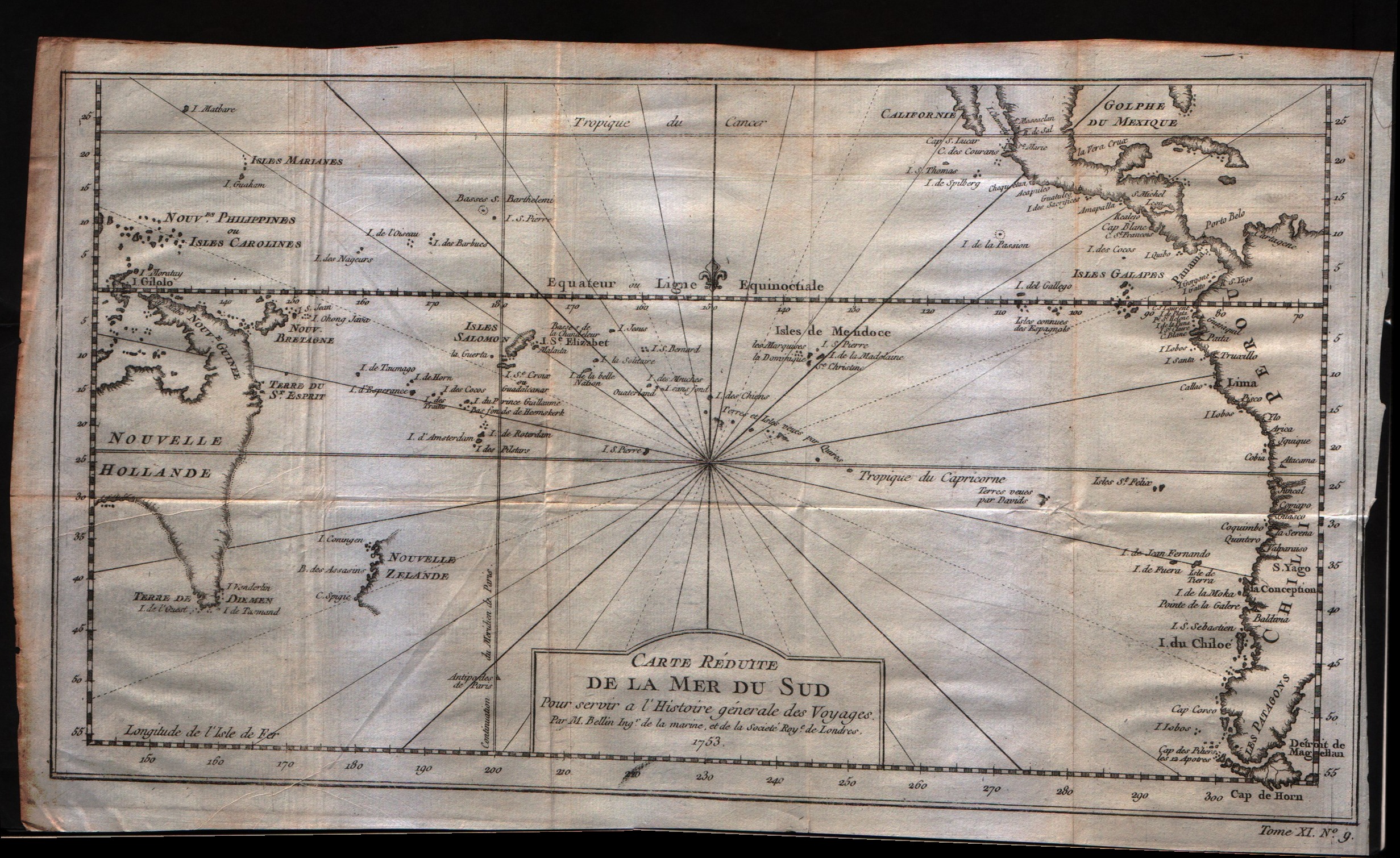
Carte reduite de la Mer Du Sud
Author
Bellin
Location shown in map
South Pacific
Edition date
1757
Edition place
Paris
Editor
--
Atlas
Historie General des Voyages -- Prevost
Price
300 Euro
State
[mint/excellent/VERY GOOD/good/fair/mediocre/poor]
Color
Black/white
Verso
Blank
Size
Plate: cm (34.3 x 21.6) inches (13.5 x 8.5) Paper: cm (34.3 x 21.6) inches (13.5 x 8.5)
Technique
Copper engraving
Note
Showing recent discoveries in the South Pacific: Australia's eastern coastline is virtually featureless, running from New Guinea to Tasmania without a break. Only a small section of New Zealand is marked.
Reference
--
Wiki
Here for more info
In stock
Available
Info
info@thetreasuremaps.com
Code
#0403
×
![Carte reduite de la Mer Du Sud by Bellin, South Pacific, 1757]()
Map title
Carte de la nouvelle Angleterre
Author
Bellin
Location shown in map
New England
Edition date
1757
Edition place
Paris
Editor
--
Atlas
Historie General des Voyages -- Prevost
Price
Please ask: info@thetreasuremaps.com
State
[mint/excellent/VERY GOOD/good/fair/mediocre/poor]On up-left missing 2mm
Color
Black/white
Verso
Blank
Size
Plate: cm (29.2 x 20.3) inches (11.5 x 7.99) Paper: cm (30.5 x 22.9) inches (12.01 x 9.02)
Technique
Copper engraving
Note
The New England colonies are named except Vermont which is still the unnamed disputed territory between New Hampshire and New York. The area covered as a whole extends from Penobscot Bay south to Chesapeake Bay and west to Lake Erie. The map illustrates provinces, towns, forts, rivers, Native American lands and relief.
Reference
--
Wiki
Here for more info
In stock
Sold
Info
info@thetreasuremaps.com
Code
#0404
×
![Carte de la nouvelle Angleterre by Bellin, New England, 1757]()
Map title
Suite du cours du Fleuve de S.Laurent depuis Quebec jusqu'au Lac Ontario
Author
Bellin
Location shown in map
--
Edition date
1757
Edition place
Paris
Editor
--
Atlas
Historie General des Voyages -- Prevost
Price
Please ask: info@thetreasuremaps.com
State
[mint/EXCELLENT/very good/good/fair/mediocre/poor]
Color
Black/white
Verso
Blank
Size
Plate: cm (27.9 x 17.8) inches (10.98 x 7.01) Paper: cm (30.5 x 22.9) inches (12.01 x 9.02)
Technique
Copper engraving
Note
No particular notes for this maps
Reference
--
Wiki
Here for more info
In stock
Sold
Info
info@thetreasuremaps.com
Code
#0405
×
![Suite du cours du Fleuve de S.Laurent depuis Quebec jusqu'au Lac Ontario by Bellin, --, 1757]()
Map title
L'Empire De La Chine
Author
Bellin
Location shown in map
--
Edition date
1757
Edition place
Paris
Editor
--
Atlas
Historie General des Voyages -- Prevost
Price
Please ask: info@thetreasuremaps.com
State
[mint/excellent/VERY GOOD/good/fair/mediocre/poor]
Color
Black/white
Verso
Blank
Size
Plate: cm (40.6 x 27.9) inches (15.98 x 10.98) Paper: cm (41.9 x 32.4) inches (16.5 x 12.76)
Technique
Copper engraving
Note
No particular notes for this maps
Reference
--
Wiki
Here for more info
In stock
Sold
Info
info@thetreasuremaps.com
Code
#0428
×
![L'Empire De La Chine by Bellin, --, 1757]()
Map title
Carte de la Baye de Hocsieu et des Entrées de la Riviere de Chang
Author
Bellin
Location shown in map
Estuary of the Chiang River now Fu-chou in the province of Fukien.
Edition date
1757
Edition place
Paris
Editor
--
Atlas
Historie General des Voyages -- Prevost
Price
Please ask: info@thetreasuremaps.com
State
[mint/EXCELLENT/very good/good/fair/mediocre/poor]
Color
Black/white
Verso
Blank
Size
Plate: cm (27.9 x 20.3) inches (10.98 x 7.99) Paper: cm (36.8 x 27.9) inches (14.49 x 10.98)
Technique
Copper engraving
Note
No particular notes for this maps
Reference
--
Wiki
Here for more info
In stock
Sold
Info
info@thetreasuremaps.com
Code
#0431
×
![Carte de la Baye de Hocsieu et des Entrées de la Riviere de Chang by Bellin, Estuary of the Chiang River now Fu-chou in the province of Fukien., 1757]()
Map title
Carte de la baye de Chin-Chew ou Chang-Chew
Author
Bellin
Location shown in map
--
Edition date
1757
Edition place
Paris
Editor
--
Atlas
Historie General des Voyages -- Prevost
Price
Please ask: info@thetreasuremaps.com
State
[mint/EXCELLENT/very good/good/fair/mediocre/poor]
Color
Black/white
Verso
Blank
Size
Plate: cm (29.2 x 21.6) inches (11.5 x 8.5) Paper: cm (30.5 x 22.9) inches (12.01 x 9.02)
Technique
Copper engraving
Note
No particular notes for this maps
Reference
--
Wiki
Here for more info
In stock
Sold
Info
info@thetreasuremaps.com
Code
#0448
×
![Carte de la baye de Chin-Chew ou Chang-Chew by Bellin, --, 1757]()
Map title
L'isle Formose
Author
Bellin
Location shown in map
Taiwan
Edition date
1757
Edition place
Paris
Editor
--
Atlas
Historie General des Voyages -- Prevost
Price
Please ask: info@thetreasuremaps.com
State
[mint/EXCELLENT/very good/good/fair/mediocre/poor]
Color
Black/white
Verso
Blank
Size
Plate: cm (25.4 x 22.9) inches (10 x 9.02) Paper: cm (30.5 x 24.1) inches (12.01 x 9.49)
Technique
Copper engraving
Note
No particular notes for this maps
Reference
--
Wiki
Here for more info
In stock
Sold
Info
info@thetreasuremaps.com
Code
#0449
×
![L'isle Formose by Bellin, Taiwan, 1757]()
Map title
Suite De L'Ocean Oriental contenant les isles del la Sonde les costes de Tunquin et de la Chine les isles du Japon les Philippines Moluques.
Author
Bellin
Location shown in map
--
Edition date
1757
Edition place
Paris
Editor
--
Atlas
Historie General des Voyages -- Prevost
Price
Please ask: info@thetreasuremaps.com
State
[mint/excellent/VERY GOOD/good/fair/mediocre/poor]
Color
Black/white
Verso
Blank
Size
Plate: cm (29.8 x 29.2) inches (11.73 x 11.5) Paper: cm (33.7 x 32.4) inches (13.27 x 12.76)
Technique
Copper engraving
Note
Note the unusual outlines of Japan and Korea. And the not well known Nouvelle Guinee
Reference
--
Wiki
Here for more info
In stock
Sold
Info
info@thetreasuremaps.com
Code
#0452
×
![Suite De L'Ocean Oriental contenant les isles del la Sonde les costes de Tunquin et de la Chine les isles du Japon les Philippines Moluques. by Bellin, --, 1757]()
Map title
Plan de la Ville et Cite de St.Francois de Quito
Author
Bellin
Location shown in map
Quito
Edition date
1757
Edition place
Paris
Editor
--
Atlas
Historie General des Voyages -- Prevost
Price
Please ask: info@thetreasuremaps.com
State
[mint/EXCELLENT/very good/good/fair/mediocre/poor]
Color
Black/white
Verso
Blank
Size
Plate: cm (36.8 x 25.4) inches (14.49 x 10) Paper: cm (33 x 17.8) inches (12.99 x 7.01)
Technique
Copper engraving
Note
No particular notes for this maps
Reference
--
Wiki
Here for more info
In stock
Sold
Info
info@thetreasuremaps.com
Code
#0459
×
![Plan de la Ville et Cite de St.Francois de Quito by Bellin, Quito, 1757]()
Map title
Plan de la Ville de Santiago
Author
Bellin
Location shown in map
Santiago
Edition date
1757
Edition place
Paris
Editor
--
Atlas
Historie General des Voyages -- Prevost
Price
Please ask: info@thetreasuremaps.com
State
[mint/EXCELLENT/very good/good/fair/mediocre/poor]
Color
Black/white
Verso
Blank
Size
Plate: cm (35.6 x 25.4) inches (14.02 x 10) Paper: cm (27.9 x 17.8) inches (10.98 x 7.01)
Technique
Copper engraving
Note
No particular notes for this maps
Reference
--
Wiki
Here for more info
In stock
Sold
Info
info@thetreasuremaps.com
Code
#0460
×
![Plan de la Ville de Santiago by Bellin, Santiago, 1757]()
Map title
Carte reduite des Terres Australes
Author
Bellin
Location shown in map
Australia
Edition date
1757
Edition place
Paris
Editor
--
Atlas
Historie General des Voyages -- Prevost
Price
Please ask: info@thetreasuremaps.com
State
[mint/excellent/VERY GOOD/good/fair/mediocre/poor] The right edge has a small tear into the plate. The right edge has a narrow margin.
Color
Black/white
Verso
Blank
Size
Plate: cm (26.7 x 20.3) inches (10.51 x 7.99) Paper: cm (29.2 x 22.9) inches (11.5 x 9.02)
Technique
Copper engraving
Note
No particular notes for this maps
Reference
--
Wiki
Here for more info
In stock
Sold
Info
info@thetreasuremaps.com
Code
#0472
×
![Carte reduite des Terres Australes by Bellin, Australia, 1757]()