1700-1799
Map title
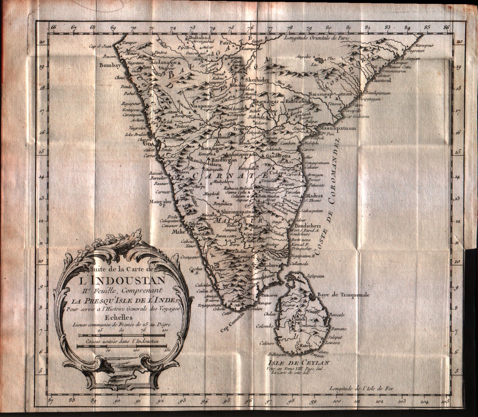
Suite de la carte de l'Indoustan, II feuille, comprendant la presqu'isle de l'Inde
Author
Bellin
Location shown in map
India
Edition date
1757
Edition place
Paris
Editor
--
Atlas
Historie General des Voyages -- Prevost
Price
125 Euro
State
[mint/EXCELLENT/very good/good/fair/mediocre/poor]
Color
Black/white
Verso
Blank
Size
Plate: cm (24.1 x 21.6) inches (9.49 x 8.5) Paper: cm (33 x 26.7) inches (12.99 x 10.51)
Technique
Copper engraving
Note
No particular notes for this maps
Reference
--
Wiki
Here for more info
In stock
Available
Info
info@thetreasuremaps.com
Code
#0547
×
![Suite de la carte de l'Indoustan, II feuille, comprendant la presqu'isle de l'Inde by Bellin, India, 1757]()
Map title
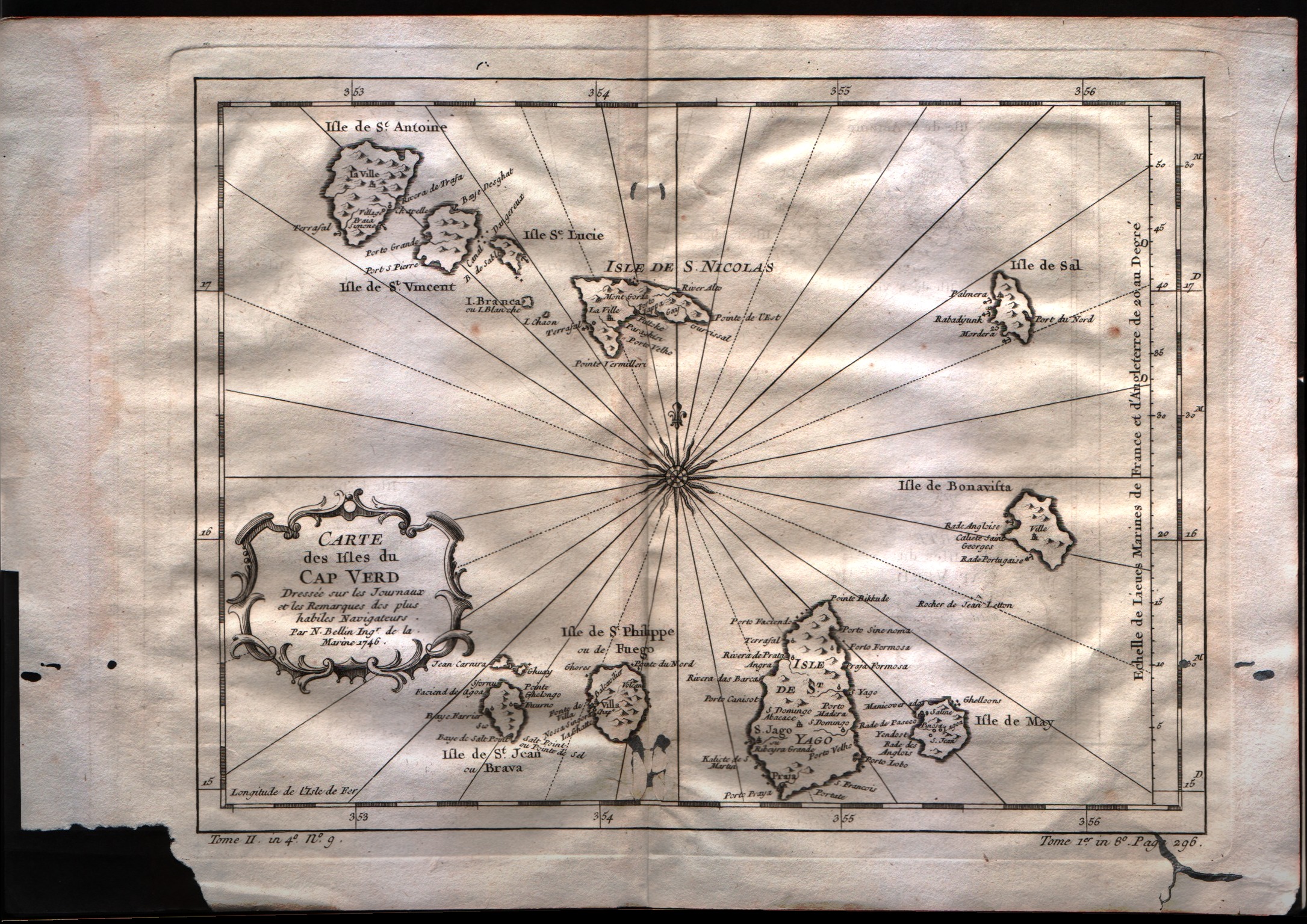
Carte des isles du Cap Verd
Author
Bellin
Location shown in map
Cape Verde island
Edition date
1757
Edition place
Paris
Editor
--
Atlas
Historie General des Voyages -- Prevost
Price
100 Euro
State
[mint/excellent/VERY GOOD/good/fair/mediocre/poor]
Color
Black/white
Verso
Blank
Size
Plate: cm (27.9 x 21.6) inches (10.98 x 8.5) Paper: cm (35.6 x 25.4) inches (14.02 x 10)
Technique
Copper engraving
Note
No particular notes for this maps
Reference
--
Wiki
Here for more info
In stock
Available
Info
info@thetreasuremaps.com
Code
#0549
×
![Carte des isles du Cap Verd by Bellin, Cape Verde island, 1757]()
Map title
Carte de la coste Occidentale d'Afrique Depuis le XII degree de latitude Septentrionale
Author
Bellin
Location shown in map
West Africa
Edition date
1757
Edition place
Paris
Editor
--
Atlas
--
Price
Please ask: info@thetreasuremaps.com
State
[mint/excellent/VERY GOOD/good/fair/mediocre/poor]
Color
Black/white
Verso
Blank
Size
Plate: cm (24.1 x 19) inches (9.49 x 7.48) Paper: cm (27.9 x 22.9) inches (10.98 x 9.02)
Technique
Copper engraving
Note
No particular notes for this maps
Reference
--
Wiki
Here for more info
In stock
Available
Info
info@thetreasuremaps.com
Code
#0550
×
![Carte de la coste Occidentale d'Afrique Depuis le XII degree de latitude Septentrionale by Bellin, West Africa, 1757]()
Map title
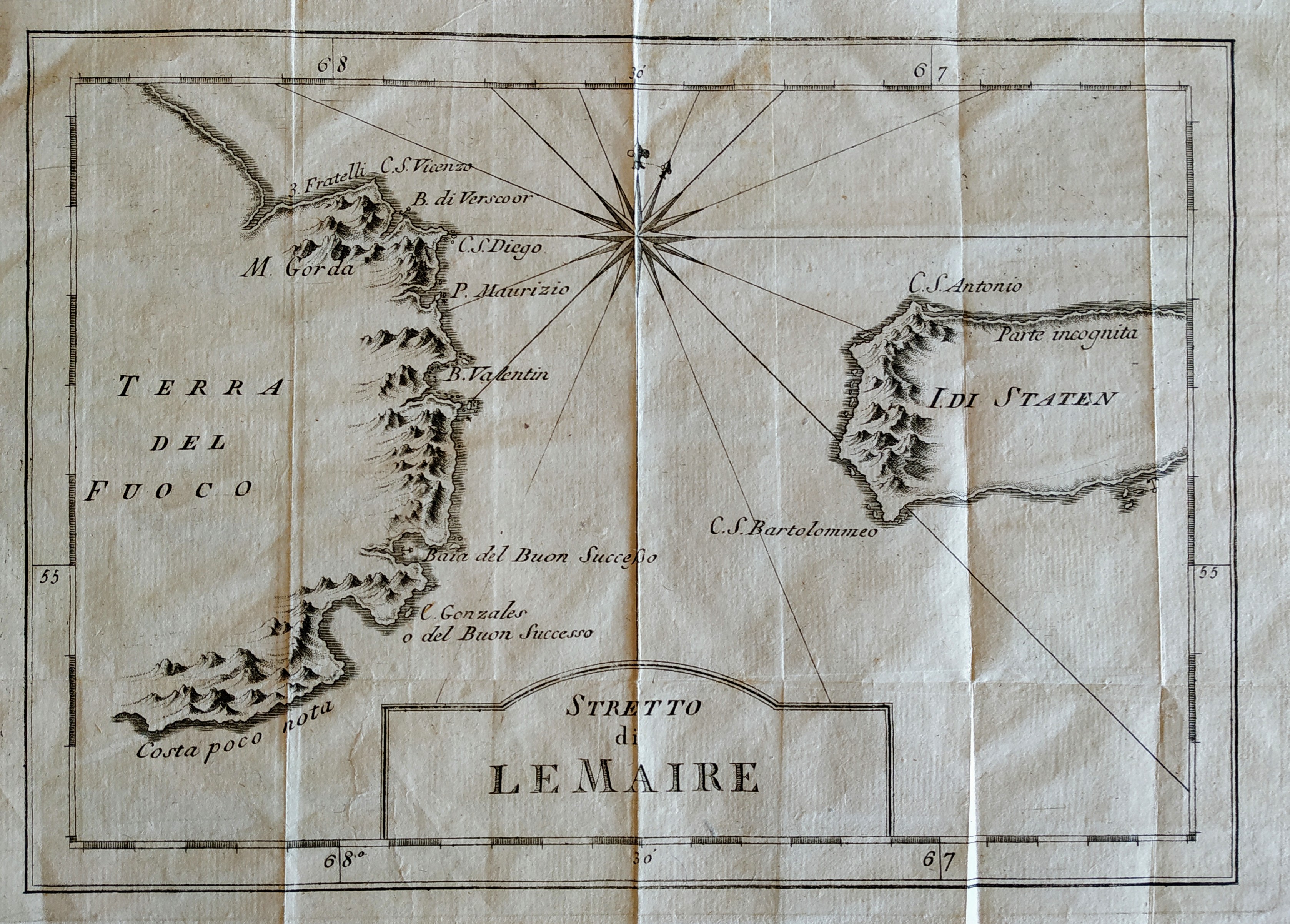
Stretto di Le Maire
Author
Bellin
Location shown in map
Magellan straits
Edition date
1757
Edition place
Paris
Editor
Prevost
Atlas
Historie General des Voyages -- Prevost
Price
75 Euro
State
[mint/EXCELLENT/very good/good/fair/mediocre/poor]
Color
Black/white
Verso
Blank
Size
Plate: cm (27 x 19) inches (10.63 x 7.48) Paper: cm (32 x 26) inches (12.6 x 10.24)
Technique
Copper engraving
Note
No particular notes for this maps
Reference
--
Wiki
Here for more info
In stock
Available
Info
info@thetreasuremaps.com
Code
#0669
×
![Stretto di Le Maire by Bellin, Magellan straits, 1757]()
Map title
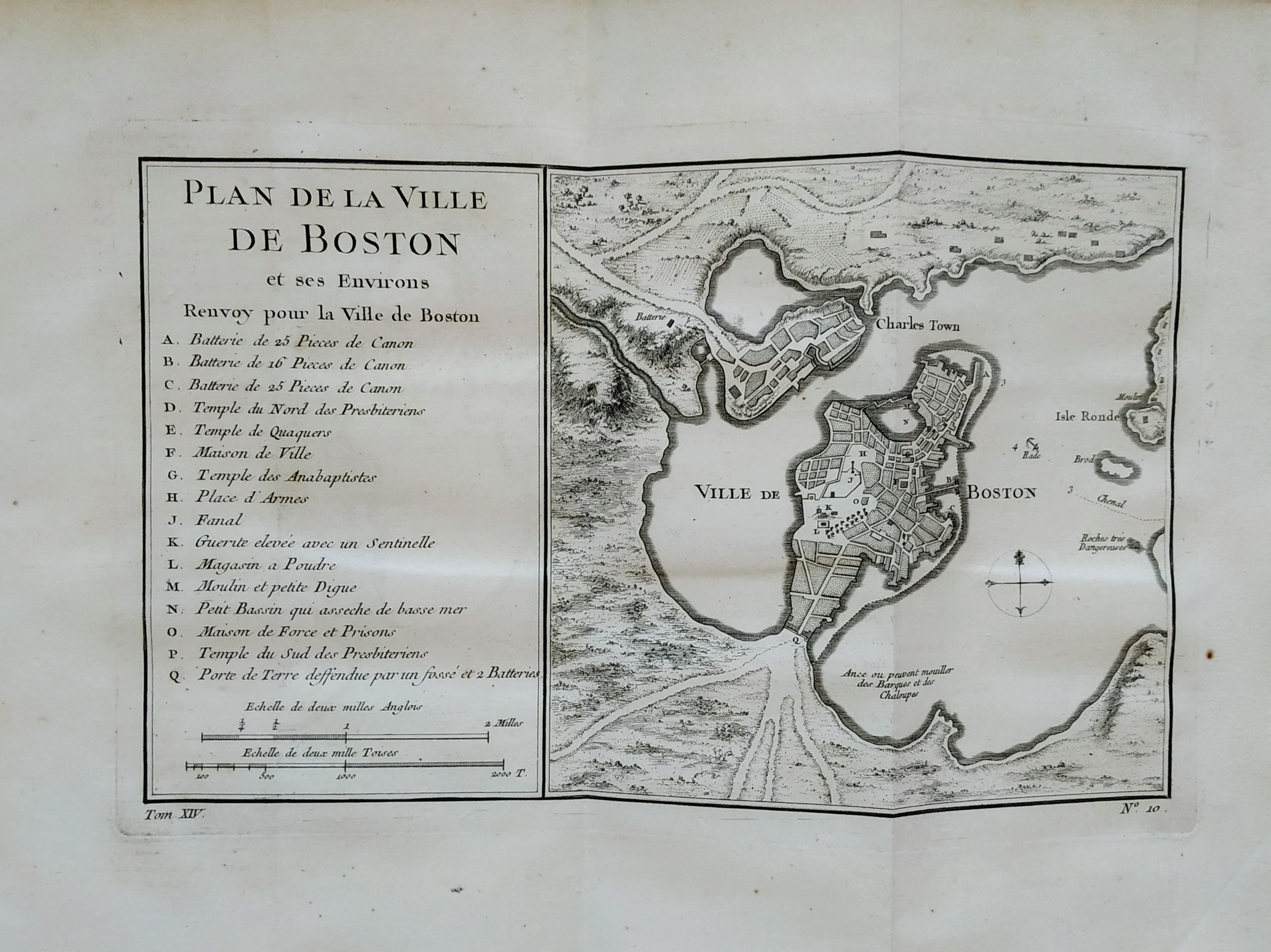
Plan de la ville de Boston
Author
Bellin
Location shown in map
Boston
Edition date
1757
Edition place
Paris
Editor
Prevost
Atlas
Historie General des Voyages -- Prevost
Price
300 Euro
State
[mint/EXCELLENT/very good/good/fair/mediocre/poor]
Color
Black/white
Verso
Blank
Size
Plate: cm (27 x 16) inches (10.63 x 6.3) Paper: cm (36 x 28) inches (14.17 x 11.02)
Technique
Copper engraving
Note
No particular notes for this maps
Reference
--
Wiki
Here for more info
In stock
Sold
Info
info@thetreasuremaps.com
Code
#0757
×
![Plan de la ville de Boston by Bellin, Boston, 1757]()
Map title
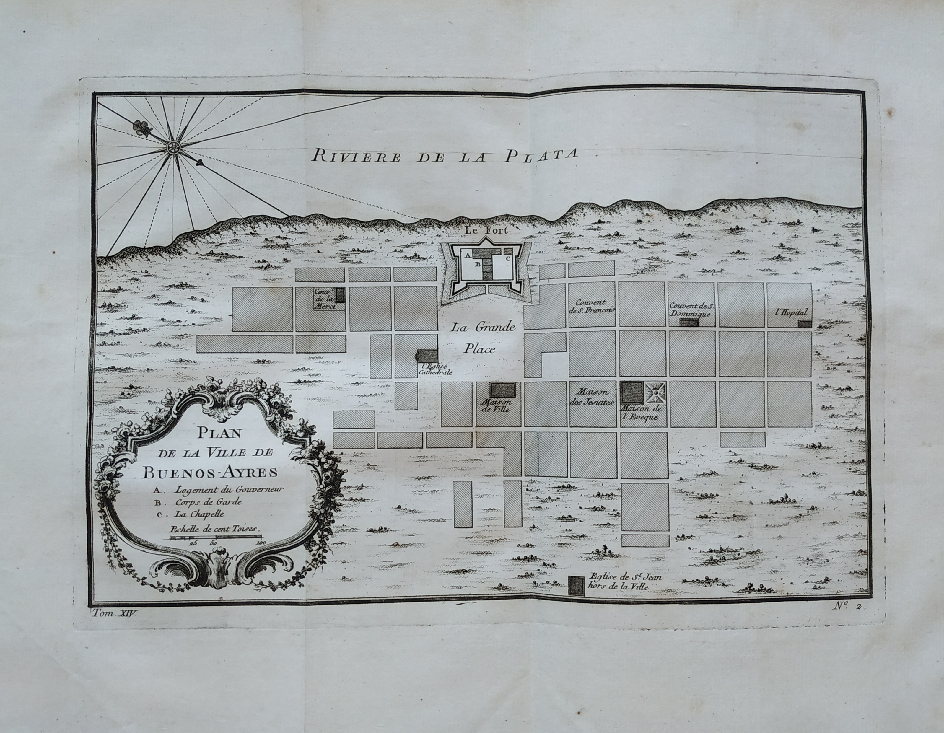
Plan de la ville de Buenos-Ayres
Author
Bellin
Location shown in map
Buenos Aires
Edition date
1757
Edition place
Paris
Editor
Prevost
Atlas
Historie General des Voyages -- Prevost
Price
150 Euro
State
[mint/EXCELLENT/very good/good/fair/mediocre/poor]
Color
Black/white
Verso
Blank
Size
Plate: cm (27 x 18) inches (10.63 x 7.09) Paper: cm (36 x 51) inches (14.17 x 20.08)
Technique
Copper engraving
Note
No particular notes for this maps
Reference
--
Wiki
Here for more info
In stock
Available
Info
info@thetreasuremaps.com
Code
#0758
×
![Plan de la ville de Buenos-Ayres by Bellin, Buenos Aires, 1757]()
Map title
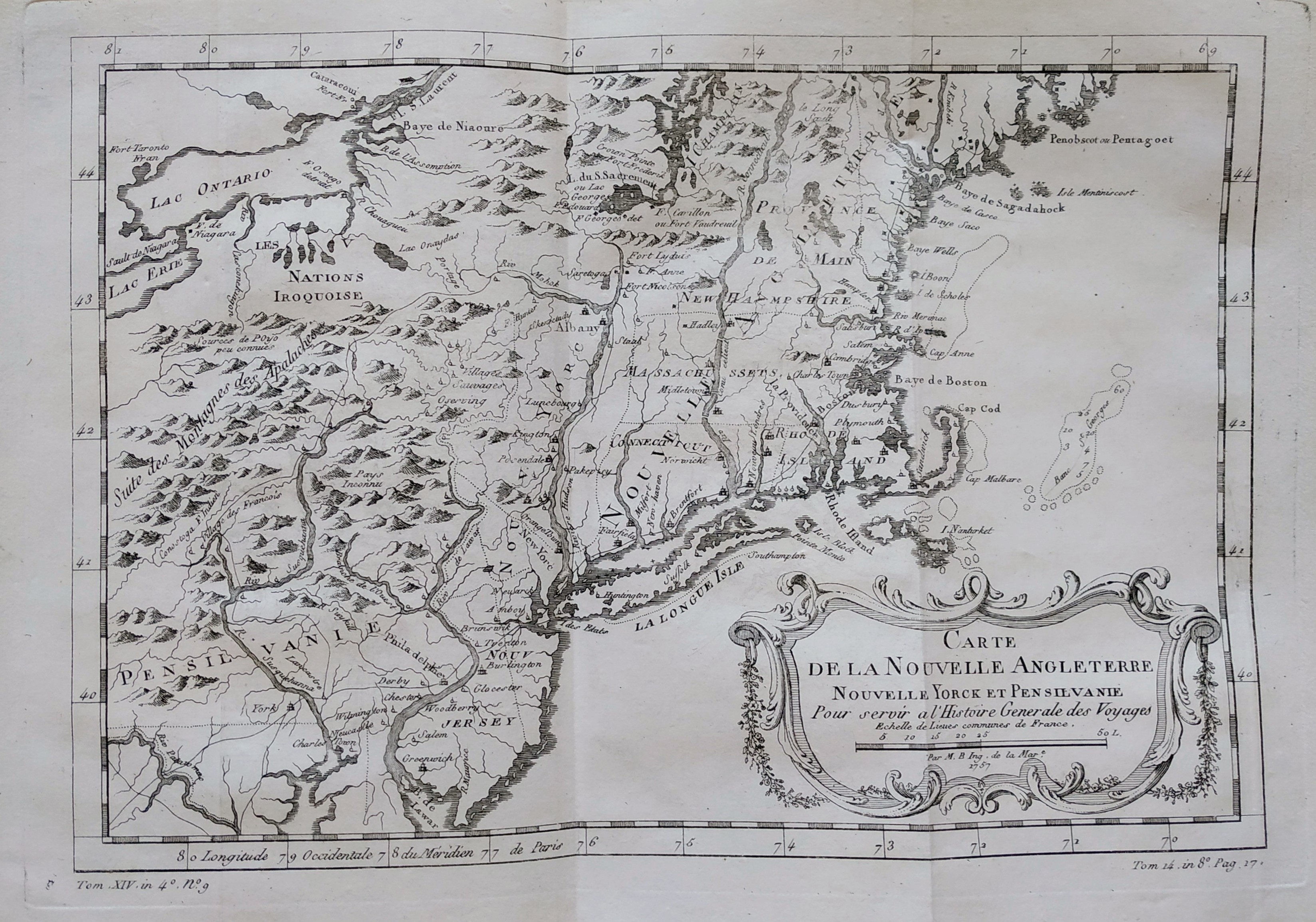
Carte de la nouvelle Angleterre
Author
Bellin
Location shown in map
New England
Edition date
1757
Edition place
Paris
Editor
Prevost
Atlas
Historie General des Voyages -- Prevost
Price
300 Euro
State
[mint/EXCELLENT/very good/good/fair/mediocre/poor]
Color
Black/white
Verso
Blank
Size
Plate: cm (29 x 20) inches (11.42 x 7.87) Paper: cm (37 x 25) inches (14.57 x 9.84)
Technique
Copper engraving
Note
The New England colonies are named except Vermont which is still the unnamed disputed territory between New Hampshire and New York. The area covered as a whole extends from Penobscot Bay south to Chesapeake Bay and west to Lake Erie. The map illustrates provinces, towns, forts, rivers, Native American lands and relief.
Reference
--
Wiki
Here for more info
In stock
Available
Info
info@thetreasuremaps.com
Code
#0762
×
![Carte de la nouvelle Angleterre by Bellin, New England, 1757]()
Map title
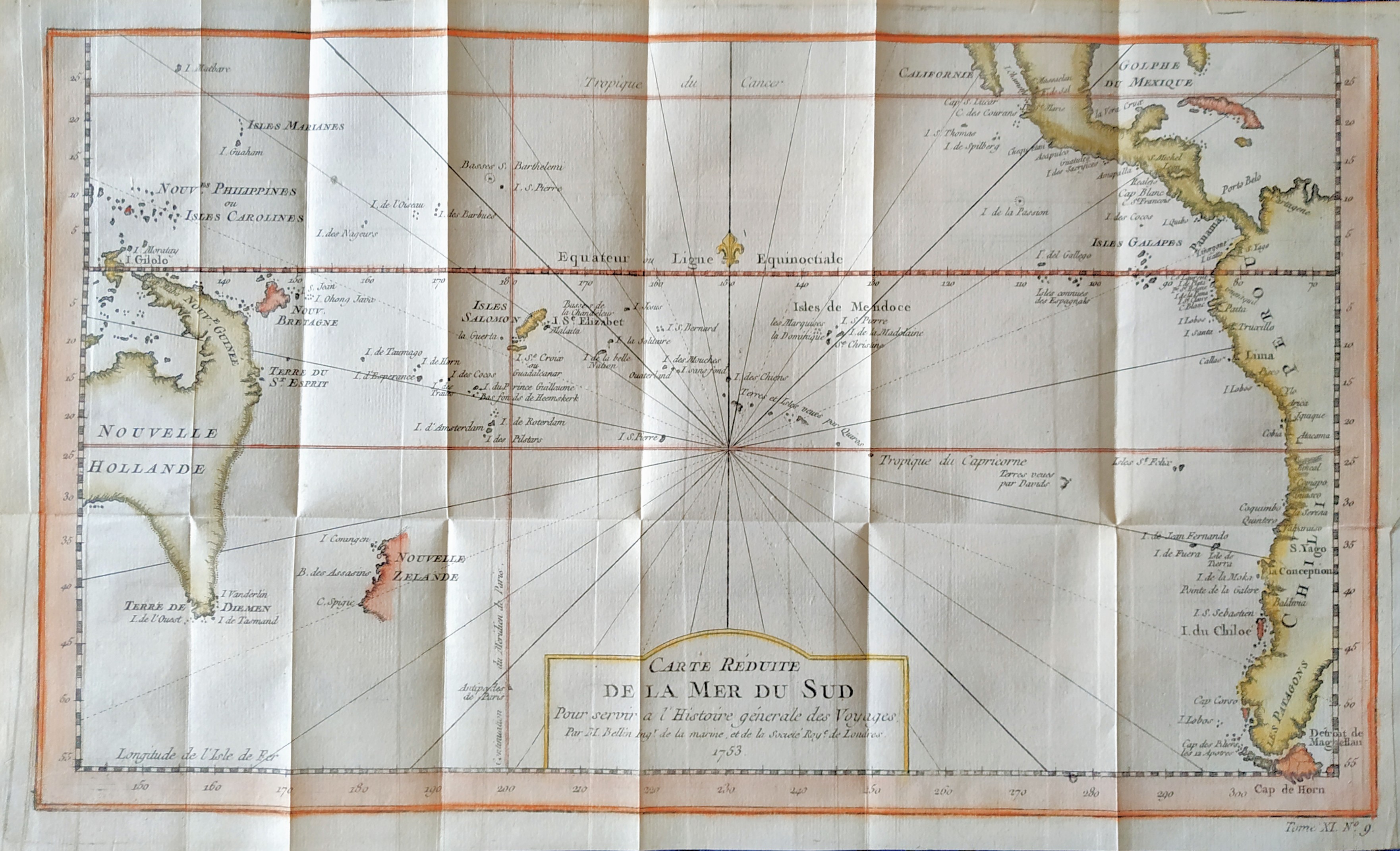
Carte reduite de la mer du Sud
Author
Bellin
Location shown in map
South Pacific
Edition date
1757
Edition place
Paris
Editor
--
Atlas
Historie General des Voyages -- Prevost
Price
300 Euro
State
[mint/EXCELLENT/very good/good/fair/mediocre/poor]
Color
Modern color
Verso
Blank
Size
Plate: cm (35.5 x 21) inches (13.98 x 8.27) Paper: cm (39 x 23) inches (15.35 x 9.06)
Technique
Copper engraving
Note
Showing recent discoveries in the South Pacific: Australia's eastern coastline is virtually featureless, running from New Guinea to Tasmania without a break. Only a small section of New Zealand is marked.
Reference
--
Wiki
Here for more info
In stock
Available
Info
info@thetreasuremaps.com
Code
#0806
×
![Carte reduite de la mer du Sud by Bellin, South Pacific, 1757]()
Map title
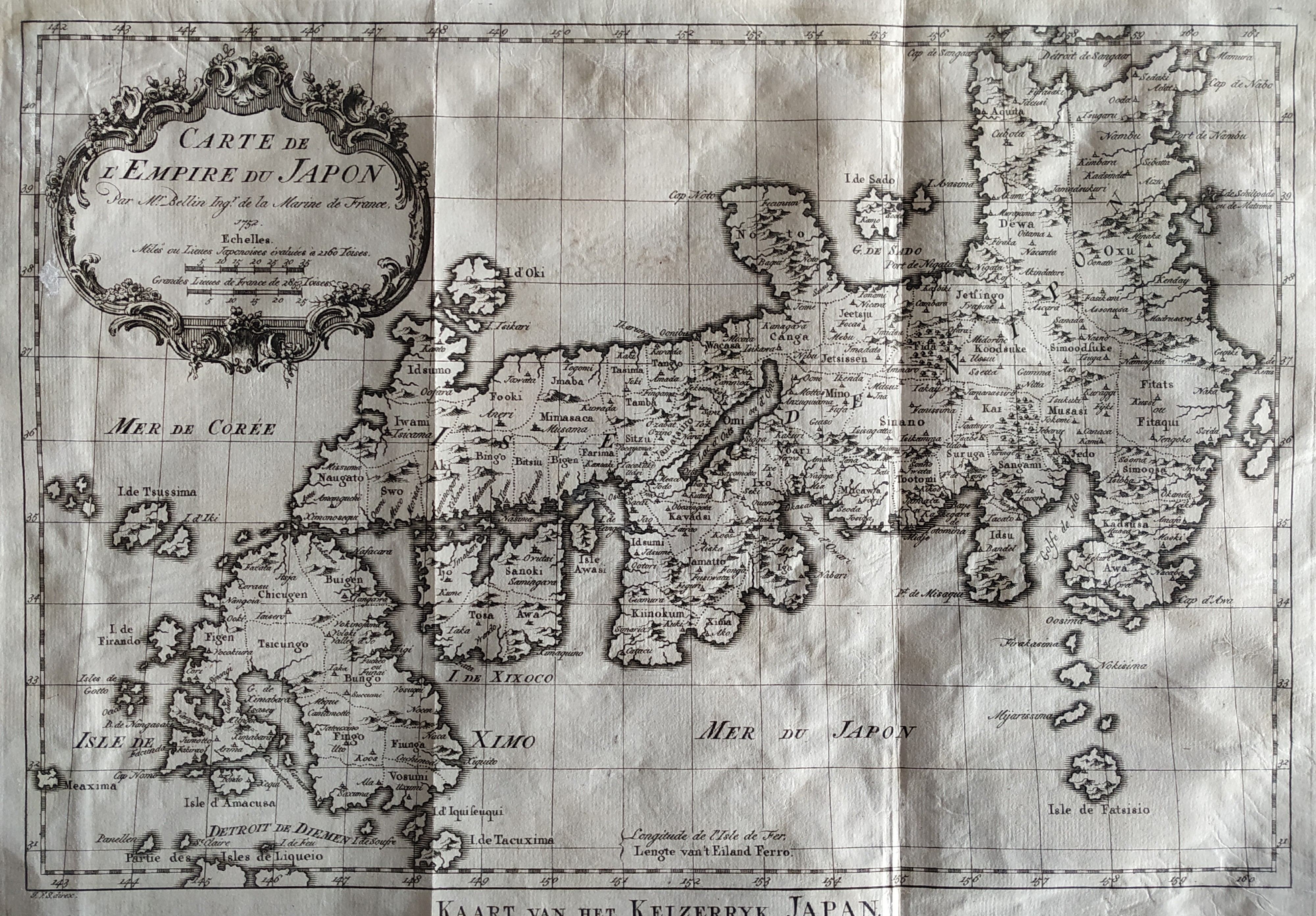
Carte De L'Empire Du Japon
Author
Bellin
Location shown in map
Japan
Edition date
1757
Edition place
Paris
Editor
--
Atlas
Historie General des Voyages -- Prevost
Price
450 Euro
State
[mint/EXCELLENT/very good/good/fair/mediocre/poor]
Color
Black/white
Verso
Blank
Size
Plate: cm (31.1 x 21.6) inches (12.24 x 8.5) Paper: cm (31.1 x 22.9) inches (12.24 x 9.02)
Technique
Copper engraving
Note
No particular notes for this maps
Reference
--
Wiki
Here for more info
In stock
Available
Info
info@thetreasuremaps.com
Code
#0807
×
![Carte De L'Empire Du Japon by Bellin, Japan, 1757]()
Map title
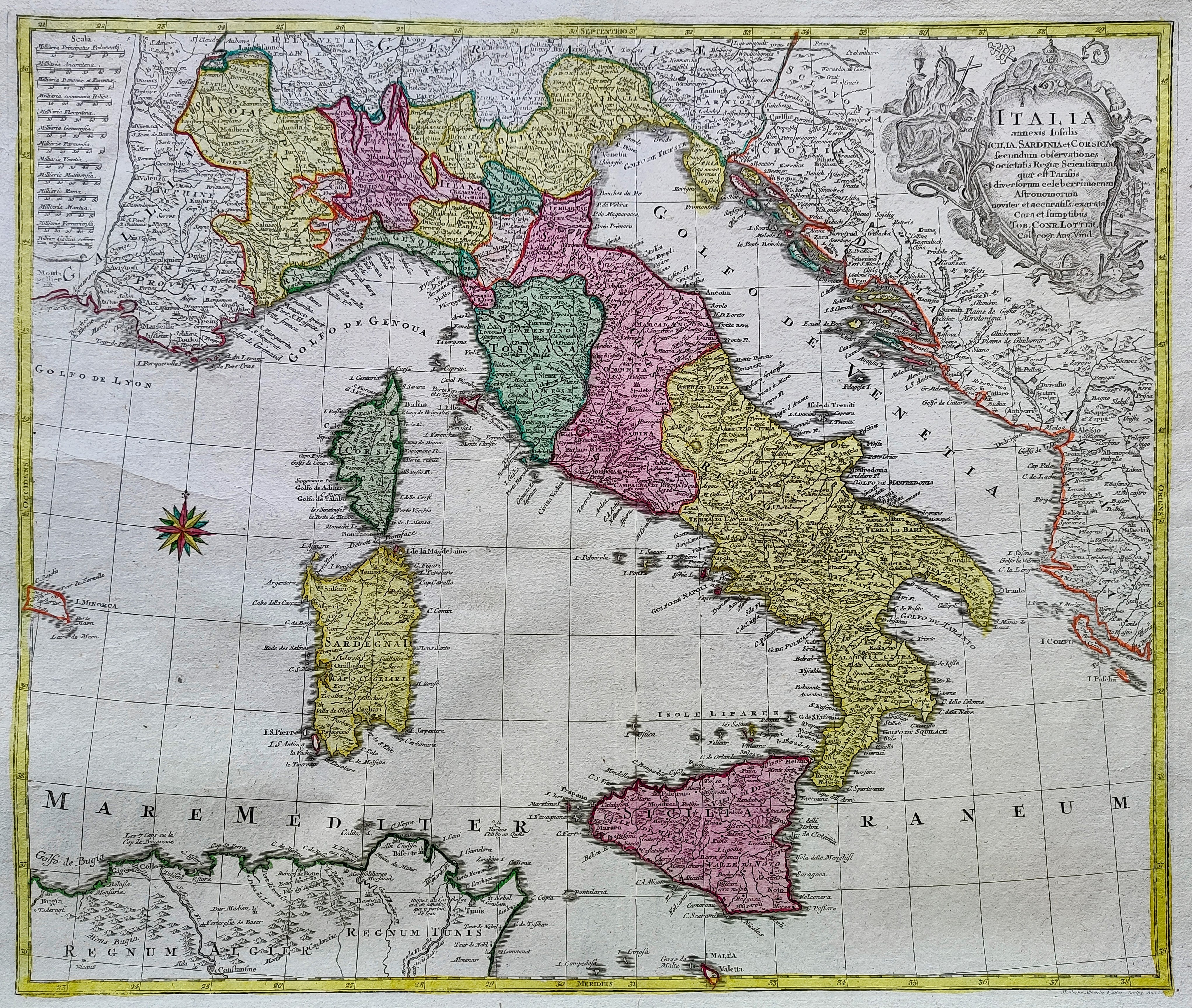
Italia annexis Insulis Sicilia Sardinia et Corsica ...
Author
Lotter
Location shown in map
Italy
Edition date
1758
Edition place
Ausburg
Editor
Lotter
Atlas
Price
500 Euro
State
[mint/EXCELLENT/very good/good/fair/mediocre/poor]
Color
Old colors
Verso
Blank
Size
Plate: cm (47 x 56) inches (18.5 x 22.05) Paper: cm (58 x 70) inches (22.83 x 27.56)
Technique
Copper engraving
Note
Reference
R.Borri L'Italia nelle antiche carte pag.233
Wiki
Here for more info
In stock
Available
Info
info@thetreasuremaps.com
Code
#0853
×
![Italia annexis Insulis Sicilia Sardinia et Corsica ... by Lotter, Italy, 1758]()

Map title
Essay D'Une Catre Reduite Contenant Les Parties Connues Du Globe Terrestre
Author
Location shown in map
World
Edition date
1759
Edition place
London
Editor
--
Atlas
A voyage round the world in the years MDCCXL, by George Anson.
Price
Please ask: info@thetreasuremaps.com
State
[mint/EXCELLENT/very good/good/fair/mediocre/poor]
Color
Black/white
Verso
Blank
Size
Plate: cm (22.2 x 40) inches (8.74 x 15.75) Paper: cm (22.2 x 40) inches (8.74 x 15.75)
Technique
--
Note
A Chart, shewing the Track of the Centurion. Interesting Pacific centred double page Mercator world map with insular California.
Reference
--
Wiki
Here for more info
In stock
Sold
Info
info@thetreasuremaps.com
Code
#0389
×
![Essay D'Une Catre Reduite Contenant Les Parties Connues Du Globe Terrestre by , World, 1759]()
Map title
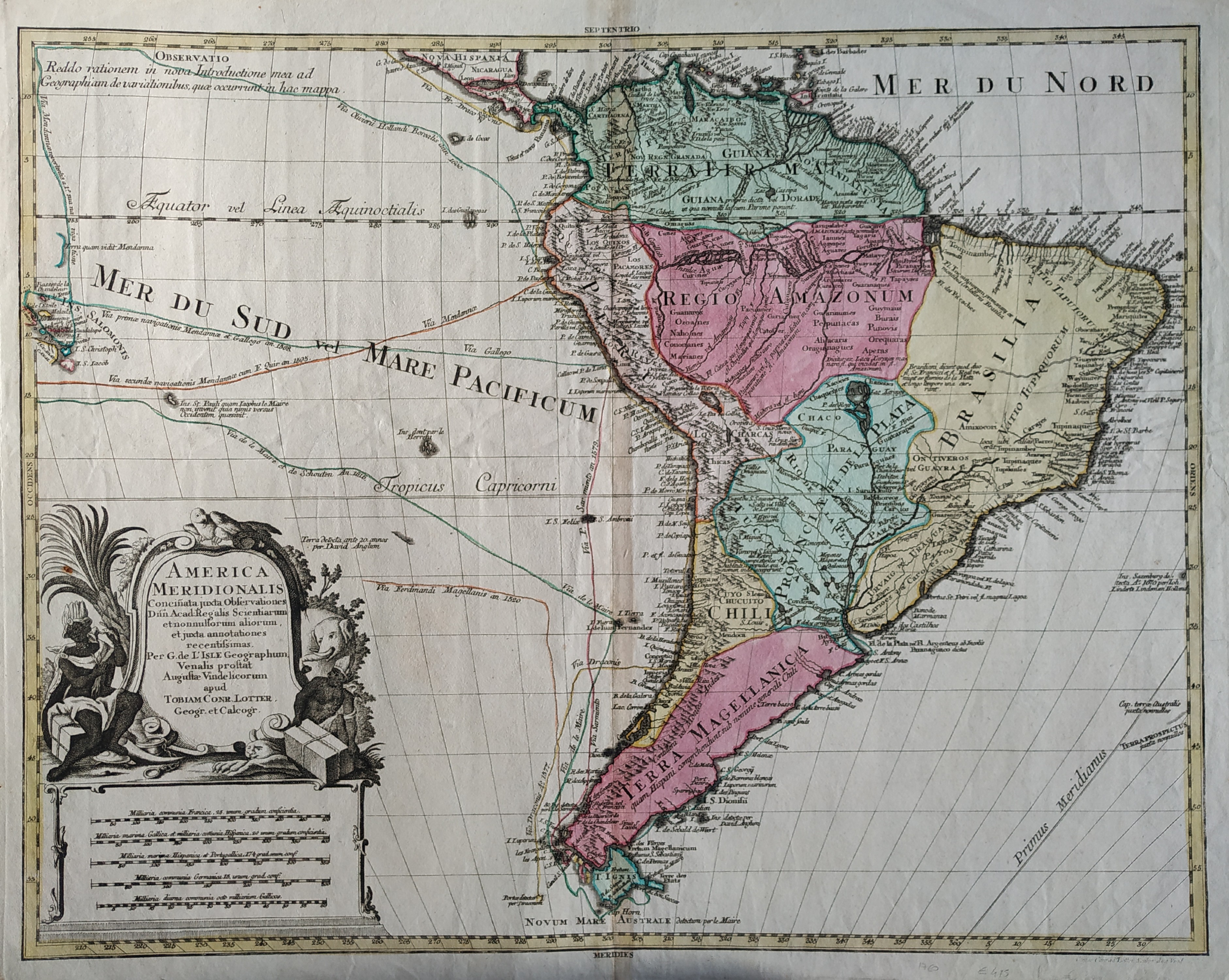
America meridionalis
Author
Lotter
Location shown in map
South America
Edition date
1760
Edition place
Paris
Editor
--
Atlas
--
Price
400 Euro
State
[mint/EXCELLENT/very good/GOOD/fair/mediocre/poor]
Color
Old colors
Verso
Blank
Size
Plate: cm (58.4 x 45.7) inches (22.99 x 17.99) Paper: cm (66 x 50.8) inches (25.98 x 20)
Technique
Copper engraving
Note
No particular notes for this maps
Reference
--
Wiki
Here for more info
In stock
Available
Info
info@thetreasuremaps.com
Code
#0053
×
![America meridionalis by Lotter, South America, 1760]()
Map title
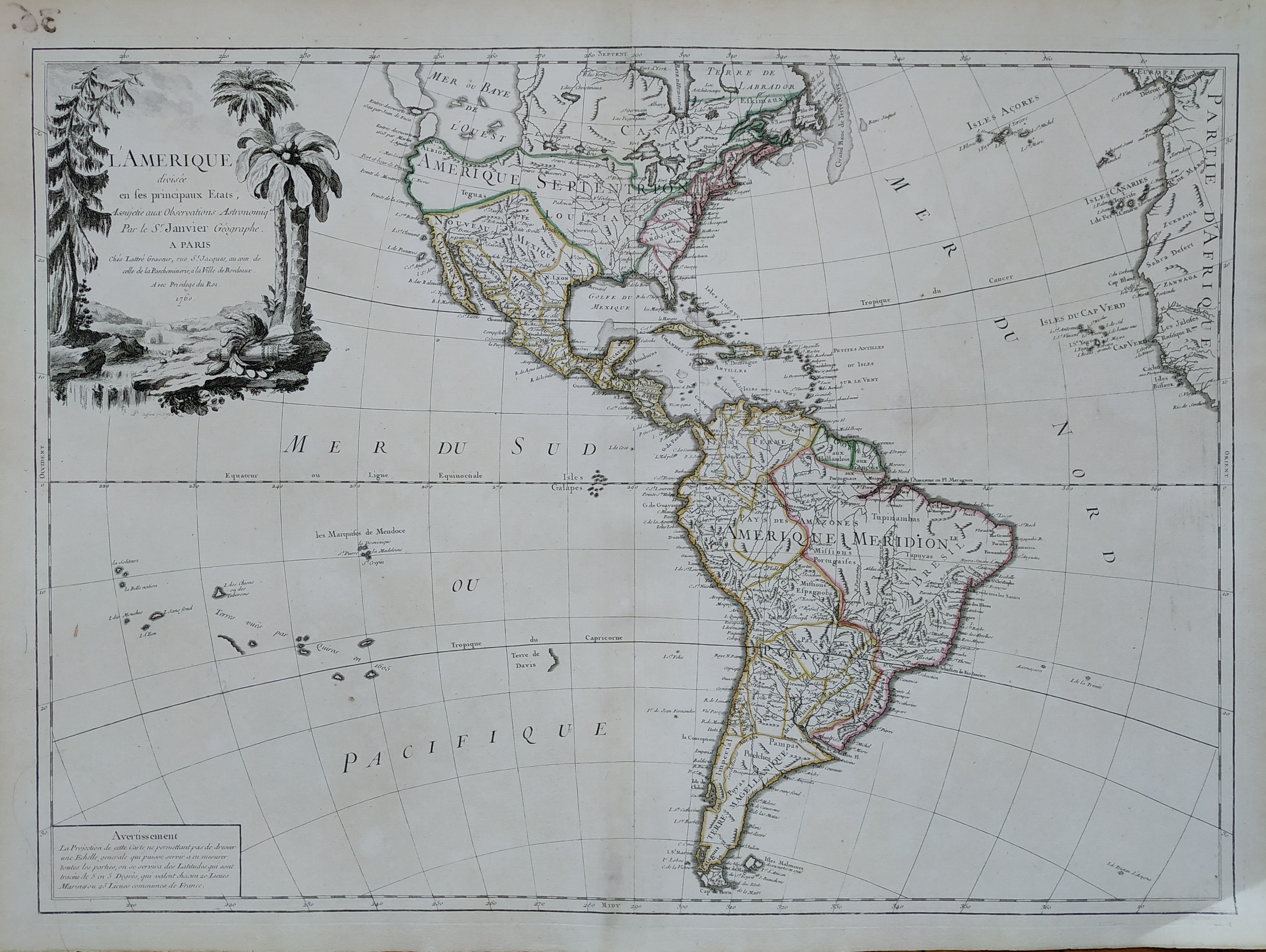
L'Amerique divisee en ses principaux etats
Author
Janvier
Location shown in map
North and south America
Edition date
1760
Edition place
Paris
Editor
Lattre
Atlas
--
Price
Please ask: info@thetreasuremaps.com
State
[mint/EXCELLENT/very good/good/fair/mediocre/poor]
Color
Old colors
Verso
Blank
Size
Plate: cm (66 x 45.7) inches (25.98 x 17.99) Paper: cm (71.1 x 53.3) inches (27.99 x 20.98)
Technique
Copper engraving
Note
No particular notes for this maps.
Reference
--
Wiki
Here for more info
In stock
Available
Info
info@thetreasuremaps.com
Code
#0566
×
![L'Amerique divisee en ses principaux etats by Janvier, North and south America, 1760]()
Map title
L'Italie
Author
Robert de Vaugondy
Location shown in map
Italy
Edition date
Circa 1760
Edition place
Paris
Editor
Boudet
Atlas
Atlas Universel
Price
300 Euro
State
[mint/EXCELLENT/very good/good/fair/mediocre/poor]
Color
Old color
Verso
Blank
Size
Plate: cm (55 x 48) inches (21.65 x 18.9) Paper: cm (65 x 54) inches (25.59 x 21.26)
Technique
Copper engraving
Note
Reference
Wiki
Here for more info
In stock
Available
Info
info@thetreasuremaps.com
Code
#0787
×
![L'Italie by Robert de Vaugondy, Italy, Circa 1760]()
Map title
Carta dell'isola di Santa Lucia
Author
Bellin
Location shown in map
Sant Lucia
Edition date
1760
Edition place
Paris
Editor
--
Atlas
Historie General des Voyages -- Prevost
Price
150 Euro
State
[mint/EXCELLENT/very good/good/fair/mediocre/poor]
Color
Black/white
Verso
Blank
Size
Plate: cm (30 x 20) inches (11.81 x 7.87) Paper: cm (33 x 23) inches (12.99 x 9.06)
Technique
Copper engraving
Note
Reference
--
Wiki
Here for more info
In stock
Available
Info
info@thetreasuremaps.com
Code
#1172
×
![Carta dell'isola di Santa Lucia by Bellin, Sant Lucia, 1760]()
Map title
Carta della Danimarca
Author
Kitchin
Location shown in map
Denmark
Edition date
Circa 1760
Edition place
Paris
Editor
Atlas
Price
75 Euro
State
[mint/EXCELLENT/very good/good/fair/mediocre/poor]
Color
Black/white
Verso
Blank
Size
Plate: cm (34 x 30) inches (13.39 x 11.81) Paper: cm (39 x 33) inches (15.35 x 12.99)
Technique
Copper engraving
Note
Reference
Wiki
Here for more info
In stock
Available
Info
info@thetreasuremaps.com
Code
#1178
×
![Carta della Danimarca by Kitchin, Denmark, Circa 1760]()
Map title
Piano della citta di Copenaghen
Author
Kitchin
Location shown in map
Copenaghen
Edition date
Circa 1760
Edition place
Paris
Editor
Atlas
Price
75 Euro
State
[mint/EXCELLENT/very good/good/fair/mediocre/poor]
Color
Black/white
Verso
Blank
Size
Plate: cm (30 x 26) inches (11.81 x 10.24) Paper: cm (39 x 30) inches (15.35 x 11.81)
Technique
Copper engraving
Note
Reference
Wiki
Here for more info
In stock
Available
Info
info@thetreasuremaps.com
Code
#1179
×
![Piano della citta di Copenaghen by Kitchin, Copenaghen, Circa 1760]()
Map title
Asia Minor in suas partes seu provincias divisa
Author
Vaugondy
Location shown in map
Turkey
Edition date
Circa 1760
Edition place
Venice
Editor
Remondini
Atlas
Atlas Universel
Price
200 Euro
State
[mint/EXCELLENT/very good/good/fair/mediocre/poor]
Color
Old colors
Verso
Blank
Size
Plate: cm (60 x 47) inches (23.62 x 18.5) Paper: cm (62 x 50) inches (24.41 x 19.69)
Technique
Copper engraving
Note
Reference
Wiki
Here for more info
In stock
Available
Info
info@thetreasuremaps.com
Code
#1383
×
![Asia Minor in suas partes seu provincias divisa by Vaugondy, Turkey, Circa 1760]()
Map title
Carte Generale du Globe Terrestre
Author
Remondini
Location shown in map
World
Edition date
1761
Edition place
Venice
Editor
Atlas
Dizionario geografico portatile
Price
250 Euro
State
[mint/excellent/VERY GOOD/good/fair/mediocre/poor]
Color
Black/white
Verso
Blank
Size
Plate: cm (33 x 22) inches (12.99 x 8.66) Paper: cm (39 x 29) inches (15.35 x 11.42)
Technique
Copper engraving
Note
Reference
Wiki
Here for more info
In stock
Available
Info
info@thetreasuremaps.com
Code
#0908
×
![Carte Generale du Globe Terrestre by Remondini, World, 1761]()
Map title
Canada, Louisiane, Possessions Anglais
Author
Robert de Vaugondy
Location shown in map
North America
Edition date
1762
Edition place
Paris
Editor
--
Atlas
Atlas Protatif
Price
300 Euro
State
[mint/EXCELLENT/very good/good/fair/mediocre/poor]
Color
Black/white
Verso
Blank
Size
Plate: cm (29.2 x 24.1) inches (11.5 x 9.49) Paper: cm (40.6 x 26.7) inches (15.98 x 10.51)
Technique
Copper engraving
Note
First state of this interesting map of the colonial possessions of England, France and Spain in North America. A large inset map covers the west coast and is most notable for its depiction of two remarkable cartographic misconceptions; a huge Mer de l' Ouest or Sea of the West and a Northwest Passage through a system of rivers and lakes connecting Hudson Bay with the Pacific based on the fictitious discoveries of Admiral de Font.
Reference
--
Wiki
Here for more info
In stock
Available
Info
info@thetreasuremaps.com
Code
#0058
×
![Canada, Louisiane, Possessions Anglais by Robert de Vaugondy, North America, 1762]()