1700-1799

Map title
Partie Orientale de L'Amerique Septentrionale
Author
Tardieu
Location shown in map
--
Edition date
1762
Edition place
--
Editor
--
Atlas
--
Price
Please ask: info@thetreasuremaps.com
State
[mint/EXCELLENT/very good/good/fair/mediocre/poor]
Color
Black/white
Verso
Blank
Size
Plate: cm (34.3 x 21.6) inches (13.5 x 8.5) Paper: cm (40.6 x 25.4) inches (15.98 x 10)
Technique
Copper engraving
Note
No particular notes for this maps
Reference
--
Wiki
Here for more info
In stock
Sold
Info
info@thetreasuremaps.com
Code
#0387
×
![Partie Orientale de L'Amerique Septentrionale by Tardieu, --, 1762]()
Map title
Cours du Fleuve S.Laurent depuis Montreal jasqu'a Tadoussac
Author
Tardieu
Location shown in map
--
Edition date
1762
Edition place
--
Editor
--
Atlas
--
Price
Please ask: info@thetreasuremaps.com
State
[mint/EXCELLENT/very good/good/fair/mediocre/poor]
Color
Black/white
Verso
Blank
Size
Plate: cm (34.3 x 21.6) inches (13.5 x 8.5) Paper: cm (40.6 x 25.4) inches (15.98 x 10)
Technique
Copper engraving
Note
No particular notes for this maps
Reference
--
Wiki
Here for more info
In stock
Sold
Info
info@thetreasuremaps.com
Code
#0388
×
![Cours du Fleuve S.Laurent depuis Montreal jasqu'a Tadoussac by Tardieu, --, 1762]()
Map title
Carta geografica del regno di Corsica
Author
Tirion
Location shown in map
Corsica
Edition date
1762
Edition place
Venice
Editor
--
Atlas
Modern History printed by Thomas Salmon.
Price
250 Euro
State
[mint/excellent/VERY GOOD/good/fair/mediocre/poor]
Color
Black/white
Verso
Blank
Size
Plate: cm (43.2 x 33) inches (17.01 x 12.99) Paper: cm (48.3 x 36.8) inches (19.02 x 14.49)
Technique
Copper engraving
Note
Detailed map of the Corsica island.
Reference
--
Wiki
Here for more info
In stock
Sold
Info
info@thetreasuremaps.com
Code
#0402
×
![Carta geografica del regno di Corsica by Tirion, Corsica, 1762]()
Map title
L'Italie divisee en ses ...
Author
Janvier
Location shown in map
Italy
Edition date
Circa 1762
Edition place
Paris
Editor
Atlas
--
Price
250 Euro
State
[mint/EXCELLENT/very good/good/fair/mediocre/poor]
Color
Old colors
Verso
Blank
Size
Plate: cm (31 x 44) inches (12.2 x 17.32) Paper: cm (39 x 53) inches (15.35 x 20.87)
Technique
Copper engraving
Note
Reference
R.Borri L'Italia nelle antiche carte pag.254
Wiki
Here for more info
In stock
Available
Info
info@thetreasuremaps.com
Code
#0855
×
![L'Italie divisee en ses ... by Janvier, Italy, Circa 1762]()
Map title
Canton Lucern sive illustris helvetiorum respublica Lucernensis cum subditis suis et confinibus
Author
Homann
Location shown in map
Lucerne
Edition date
1763
Edition place
Nuremberg
Editor
Atlas
Price
200 Euro
State
[mint/EXCELLENT/very good/good/fair/mediocre/poor]
Color
Old colors
Verso
Blank
Size
Plate: cm (51 x 59) inches (20.08 x 23.23) Paper: cm (55 x 64) inches (21.65 x 25.2)
Technique
Copper engraving
Note
Reference
Wiki
Here for more info
In stock
Available
Info
info@thetreasuremaps.com
Code
#0735
×
![Canton Lucern sive illustris helvetiorum respublica Lucernensis cum subditis suis et confinibus by Homann, Lucerne, 1763]()
Map title
L'Italie
Author
Le Rouge
Location shown in map
Italy
Edition date
Circa 1765
Edition place
Paris
Editor
--
Atlas
Atlas Nouveau Portatif l'usage des militaries et du voyageur
Price
200 Euro
State
[mint/EXCELLENT/very good/good/fair/mediocre/poor]
Color
Old outlined
Verso
Blank
Size
Plate: cm (20.3 x 27.3) inches (7.99 x 10.75) Paper: cm (20.3 x 27.3) inches (7.99 x 10.75)
Technique
Copper engraving
Note
Reference
R.Borri L'Italia nelle antiche carte pag.157
Wiki
Here for more info
In stock
Available
Info
info@thetreasuremaps.com
Code
#0158
×
![L'Italie by Le Rouge, Italy, Circa 1765]()
Map title
L'Italie divisee ...
Author
Louise Brion De La Tour
Location shown in map
Italy
Edition date
1766
Edition place
Paris
Editor
Atlas
Atlas General
Price
300 Euro
State
[mint/EXCELLENT/very good/good/fair/mediocre/poor]
Color
Old colors
Verso
Blank
Size
Plate: cm (53 x 37) inches (20.87 x 14.57) Paper: cm (55 x 39) inches (21.65 x 15.35)
Technique
Copper engraving
Note
Reference
R.Borri L'Italia nelle antiche carte pag.257
Wiki
Here for more info
In stock
Available
Info
info@thetreasuremaps.com
Code
#1013
×
![L'Italie divisee ... by Louise Brion De La Tour, Italy, 1766]()
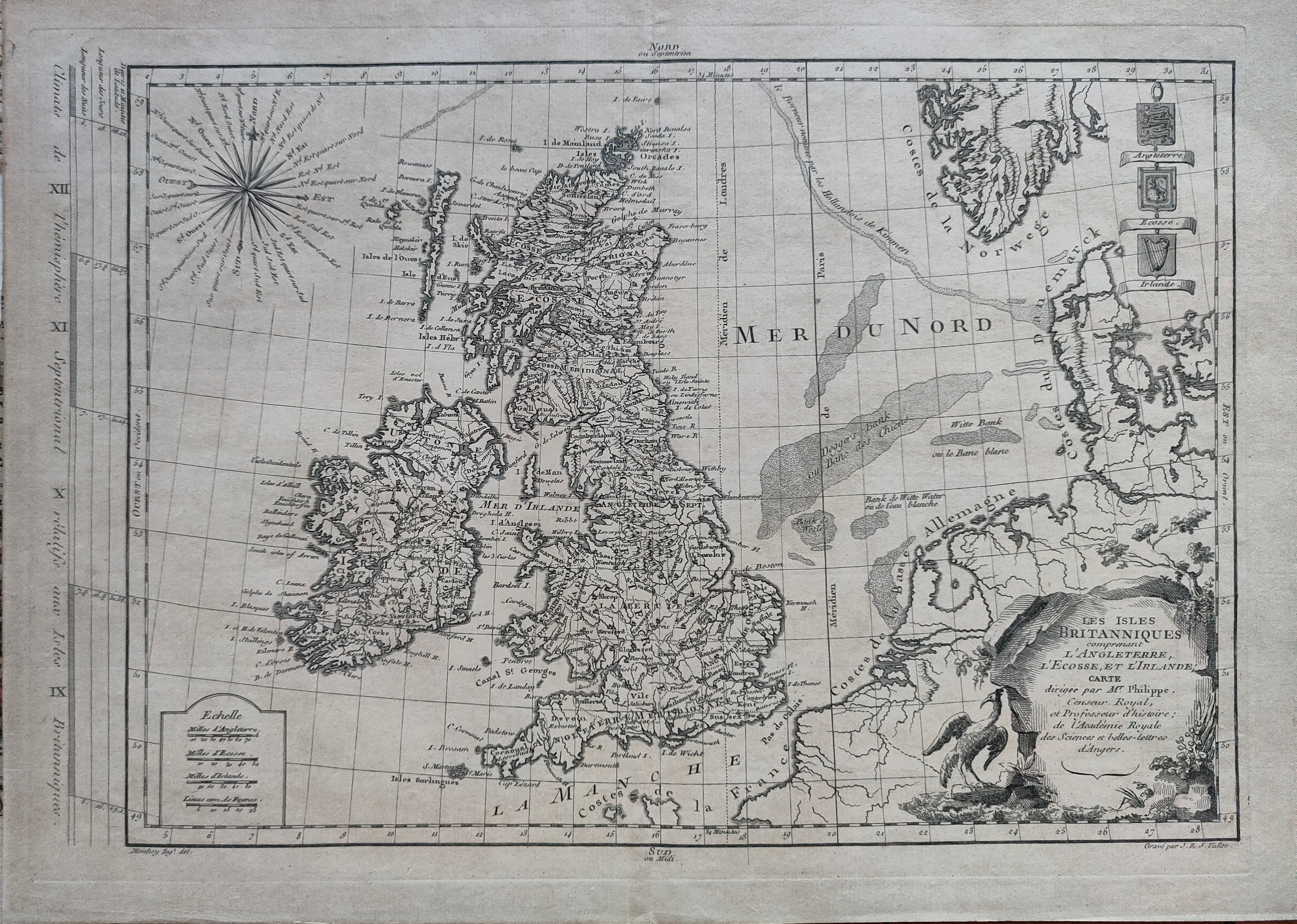
Map title
Les isles Britanniques
Author
Philippe
Location shown in map
British Isles
Edition date
1767
Edition place
Paris
Editor
Atlas
Price
125 Euro
State
[mint/EXCELLENT/very good/good/fair/mediocre/poor]
Color
Black/white
Verso
Blank
Size
Plate: cm (40 x 27) inches (15.75 x 10.63) Paper: cm (44 x 31) inches (17.32 x 12.2)
Technique
Copper engraving
Note
Reference
Wiki
Here for more info
In stock
Available
Info
info@thetreasuremaps.com
Code
#1215
×
![Les isles Britanniques by Philippe, British Isles, 1767]()
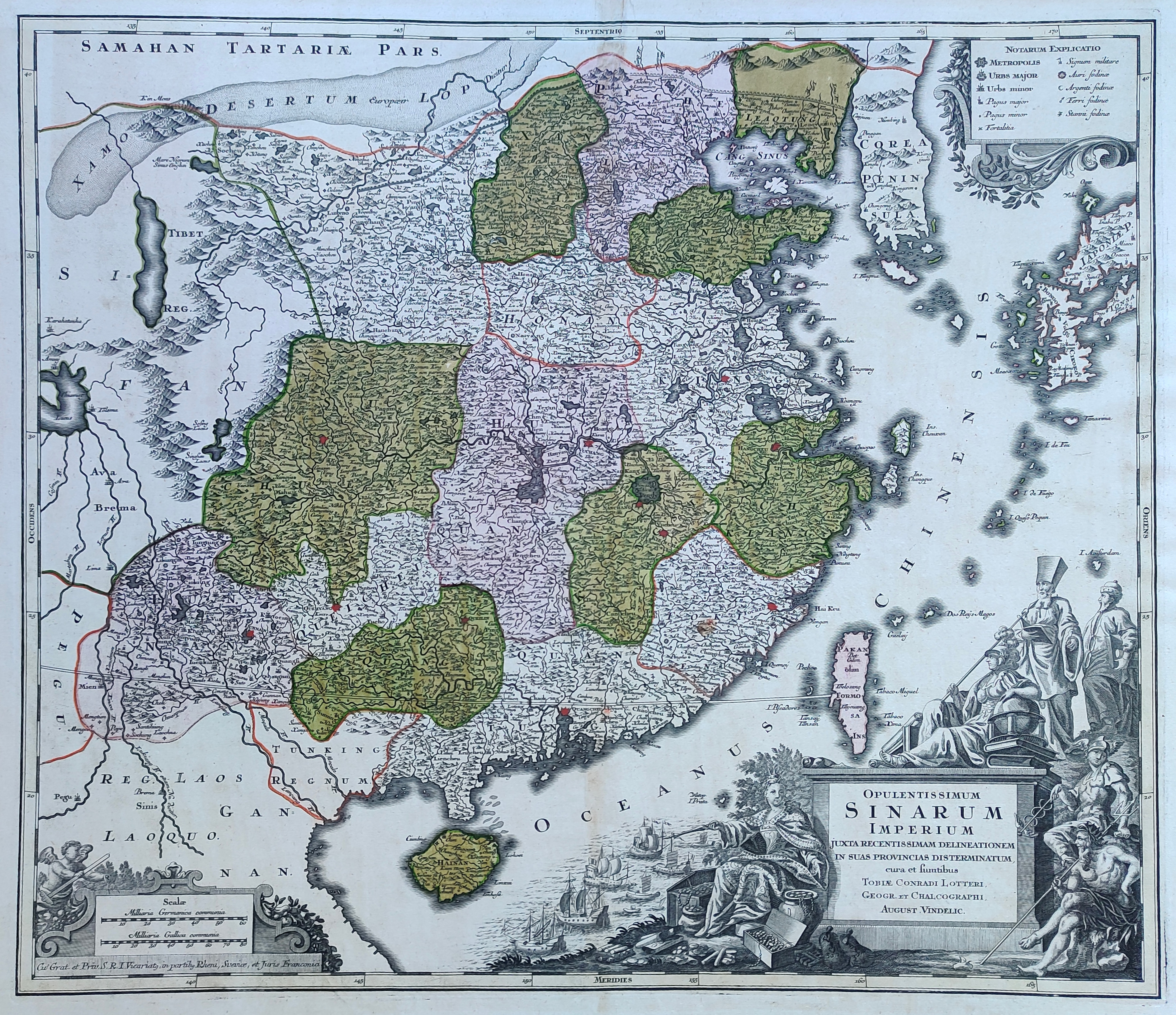
Map title
Opulentissimmun Sinarium Imperium
Author
Lotter
Location shown in map
China
Edition date
Circa 1770
Edition place
Augsburg
Editor
Atlas
Price
600 Euro
State
[mint/EXCELLENT/very good/good/fair/mediocre/poor]
Color
Old colors
Verso
Blank
Size
Plate: cm (57 x 50) inches (22.44 x 19.69) Paper: cm (68 x 55) inches (26.77 x 21.65)
Technique
Copper engraving
Note
Reference
--
Wiki
Here for more info
In stock
Available
Info
info@thetreasuremaps.com
Code
#1212
×
![Opulentissimmun Sinarium Imperium by Lotter, China, Circa 1770]()
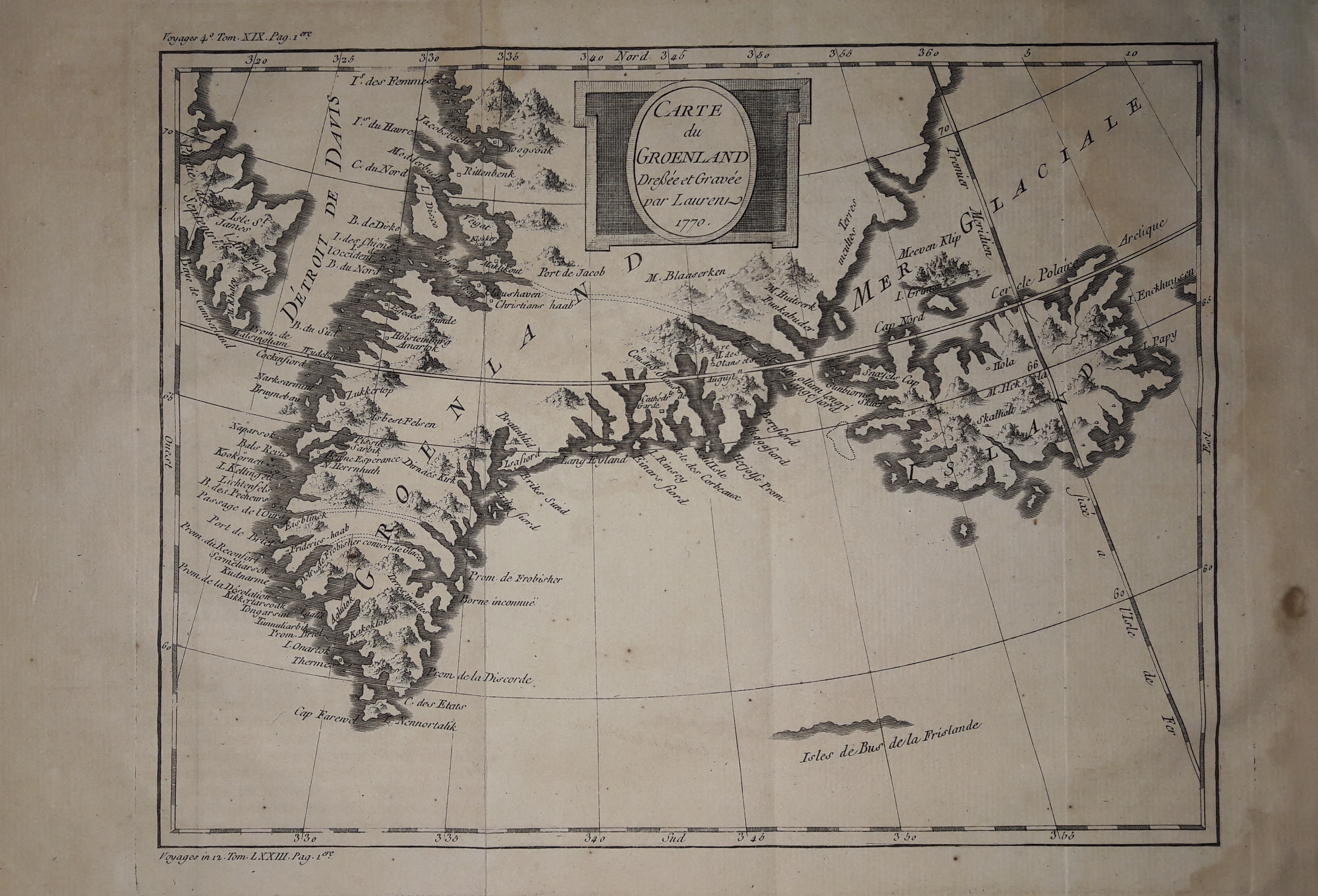
Map title
Carte du Groenland
Author
Bellin
Location shown in map
Greenland and Iceland
Edition date
1770
Edition place
Paris
Editor
--
Atlas
Historie General des Voyages -- Prevost
Price
150 Euro
State
[mint/EXCELLENT/very good/good/fair/mediocre/poor]
Color
Black/white
Verso
Blank
Size
Plate: cm (25 x 20) inches (9.84 x 7.87) Paper: cm (33 x 24) inches (12.99 x 9.45)
Technique
Copper engraving
Note
No particular notes for this maps
Reference
--
Wiki
Here for more info
In stock
Available
Info
info@thetreasuremaps.com
Code
#0632
×
![Carte du Groenland by Bellin, Greenland and Iceland, 1770]()
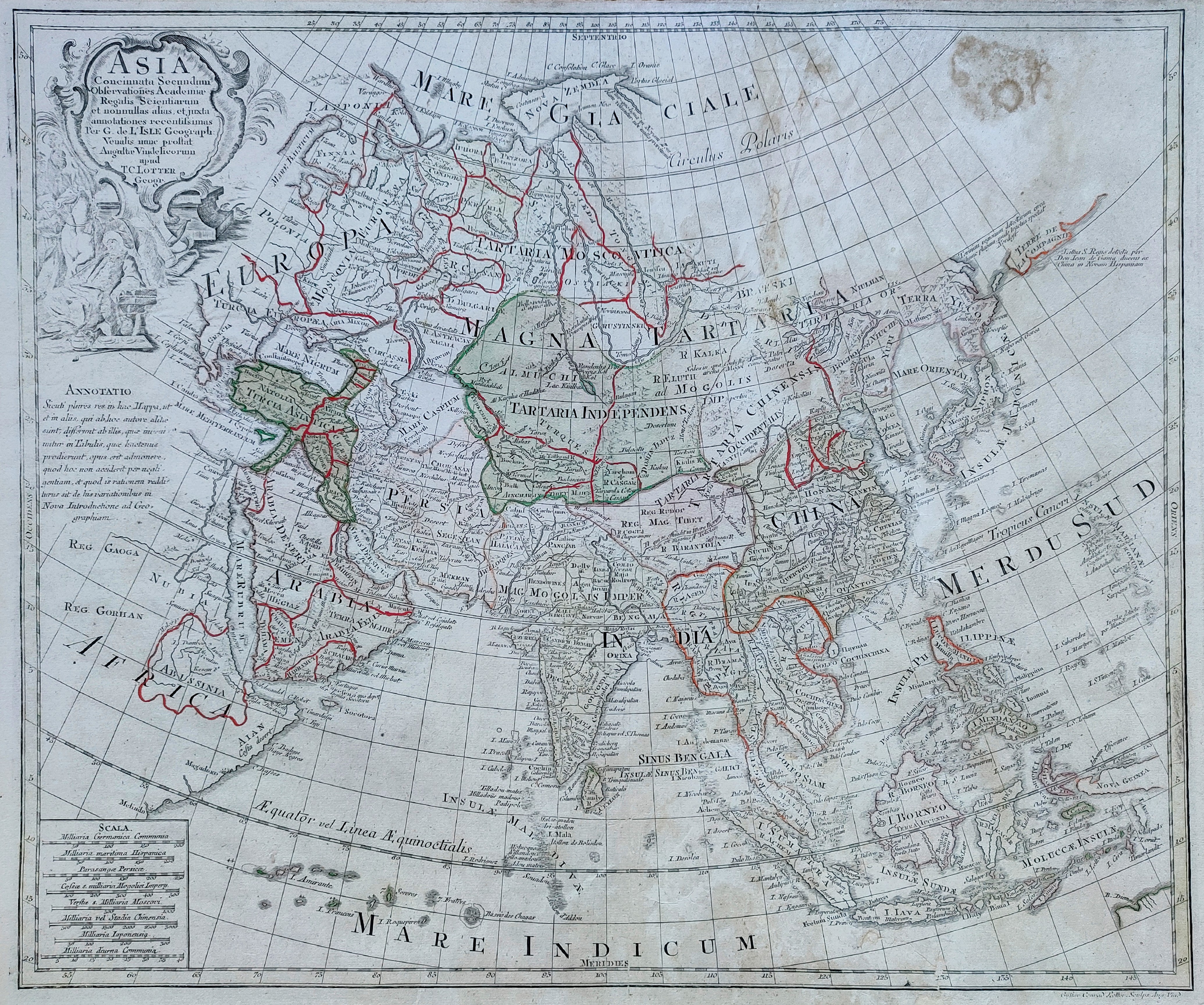
Map title
Asia
Author
Lotter
Location shown in map
Asia
Edition date
1770
Edition place
Ausburg
Editor
Atlas
Atlas novus sive tabulae geographice
Price
300 Euro
State
[mint/excellent/VERY GOOD/good/fair/mediocre/poor]
Color
Old colors
Verso
Blank
Size
Plate: cm (57 x 49) inches (22.44 x 19.29) Paper: cm (64 x 52) inches (25.2 x 20.47)
Technique
Copper engraving
Note
Reference
Wiki
Here for more info
In stock
Available
Info
info@thetreasuremaps.com
Code
#0849
Asia
Author
Lotter
Location shown in map
Asia
Edition date
1770
Edition place
Ausburg
Editor
Atlas
Atlas novus sive tabulae geographice
Price
300 Euro
State
[mint/excellent/VERY GOOD/good/fair/mediocre/poor]
Color
Old colors
Verso
Blank
Size
Plate: cm (57 x 49) inches (22.44 x 19.29) Paper: cm (64 x 52) inches (25.2 x 20.47)
Technique
Copper engraving
Note
Reference
Wiki
Here for more info
In stock
Available
Info
info@thetreasuremaps.com
Code
#0849
×
![Asia by Lotter, Asia, 1770]()
Map title
Neue Vorstellung von gantz Italien
Author
Location shown in map
Italy
Edition date
Circa 1770
Edition place
Editor
Atlas
Price
200 Euro
State
[mint/EXCELLENT/very good/good/fair/mediocre/poor]
Color
Old colors
Verso
Blank
Size
Plate: cm (43 x 24) inches (16.93 x 9.45) Paper: cm (48 x 27) inches (18.9 x 10.63)
Technique
Copper engraving
Note
Reference
Wiki
Here for more info
In stock
Sold
Info
info@thetreasuremaps.com
Code
#0903
×
![Neue Vorstellung von gantz Italien by , Italy, Circa 1770]()
Map title
Italy
Author
Thomas Jefferys
Location shown in map
Italy
Edition date
1770
Edition place
London
Editor
Atlas
Price
125 Euro
State
[mint/EXCELLENT/very good/good/fair/mediocre/poor]
Color
Old colors
Verso
Blank
Size
Plate: cm (23 x 18) inches (9.06 x 7.09) Paper: cm (25 x 20) inches (9.84 x 7.87)
Technique
Copper engraving
Note
Reference
R.Borri L'Italia nelle antiche carte pag.233
Wiki
Here for more info
In stock
Available
Info
info@thetreasuremaps.com
Code
#1082
Italy
Author
Thomas Jefferys
Location shown in map
Italy
Edition date
1770
Edition place
London
Editor
Atlas
Price
125 Euro
State
[mint/EXCELLENT/very good/good/fair/mediocre/poor]
Color
Old colors
Verso
Blank
Size
Plate: cm (23 x 18) inches (9.06 x 7.09) Paper: cm (25 x 20) inches (9.84 x 7.87)
Technique
Copper engraving
Note
Reference
R.Borri L'Italia nelle antiche carte pag.233
Wiki
Here for more info
In stock
Available
Info
info@thetreasuremaps.com
Code
#1082
×
![Italy by Thomas Jefferys, Italy, 1770]()
Map title
America Septentrionalis
Author
Lotter
Location shown in map
North America
Edition date
Circa 1770
Edition place
Augsburg
Editor
Atlas
Price
600 Euro
State
[mint/EXCELLENT/very good/good/fair/mediocre/poor]
Color
Old colors
Verso
Blank
Size
Plate: cm (59 x 45) inches (23.23 x 17.72) Paper: cm (74 x 59) inches (29.13 x 23.23)
Technique
Copper engraving
Note
Reference
--
Wiki
Here for more info
In stock
Available
Info
info@thetreasuremaps.com
Code
#1209
×
![America Septentrionalis by Lotter, North America, Circa 1770]()

Map title
La France divisee suivant ses Provinces ou Gouvernements Militaire. Par le S.r Robert Vaugondy Geographe
Author
Robert de Vaugondy
Location shown in map
France
Edition date
1771
Edition place
Paris
Editor
Delamarche
Atlas
Atlas moderne. Seconde partie.
Price
250 Euro
State
[mint/excellent/VERY GOOD/good/fair/mediocre/poor]
Color
Old outlined
Verso
Blank
Size
Plate: cm (71 x 50) inches (27.95 x 19.69) Paper: cm (74 x 51) inches (29.13 x 20.08)
Technique
Copper engraving
Note
Reference
Wiki
Here for more info
In stock
Available
Info
info@thetreasuremaps.com
Code
#0772
×
![La France divisee suivant ses Provinces ou Gouvernements Militaire. Par le S.r Robert Vaugondy Geographe by Robert de Vaugondy, France, 1771]()
Map title
Carte von neuen welt ...
Author
Buffon
Location shown in map
All America
Edition date
1771
Edition place
Berlin
Editor
Atlas
Price
150 Euro
State
[mint/EXCELLENT/very good/good/fair/mediocre/poor]
Color
Old colors
Verso
Blank
Size
Plate: cm (18 x 22) inches (7.09 x 8.66) Paper: cm (19 x 25) inches (7.48 x 9.84)
Technique
Copper engraving
Note
Reference
Wiki
Here for more info
In stock
Available
Info
info@thetreasuremaps.com
Code
#1242
×
![Carte von neuen welt ... by Buffon, All America, 1771]()
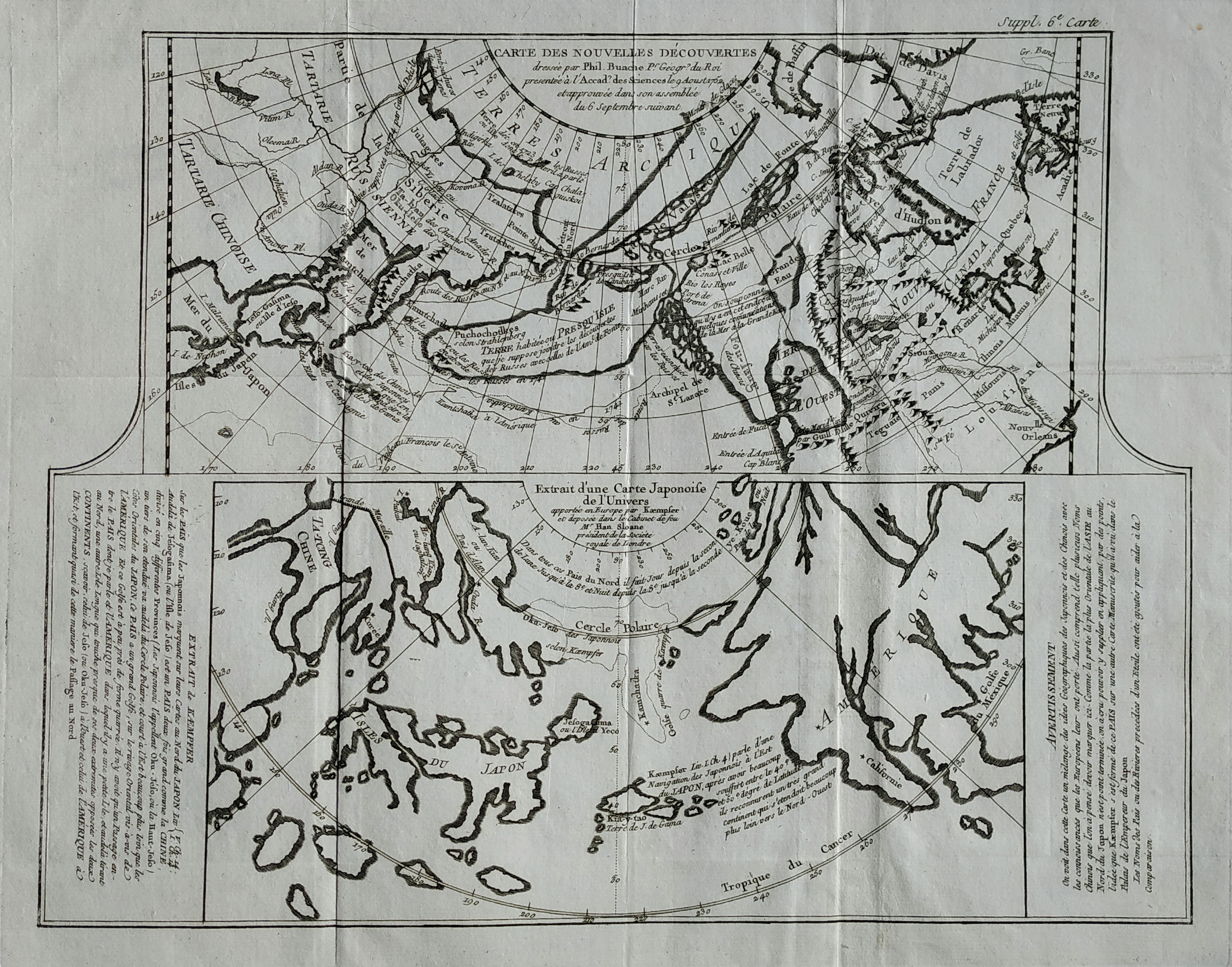
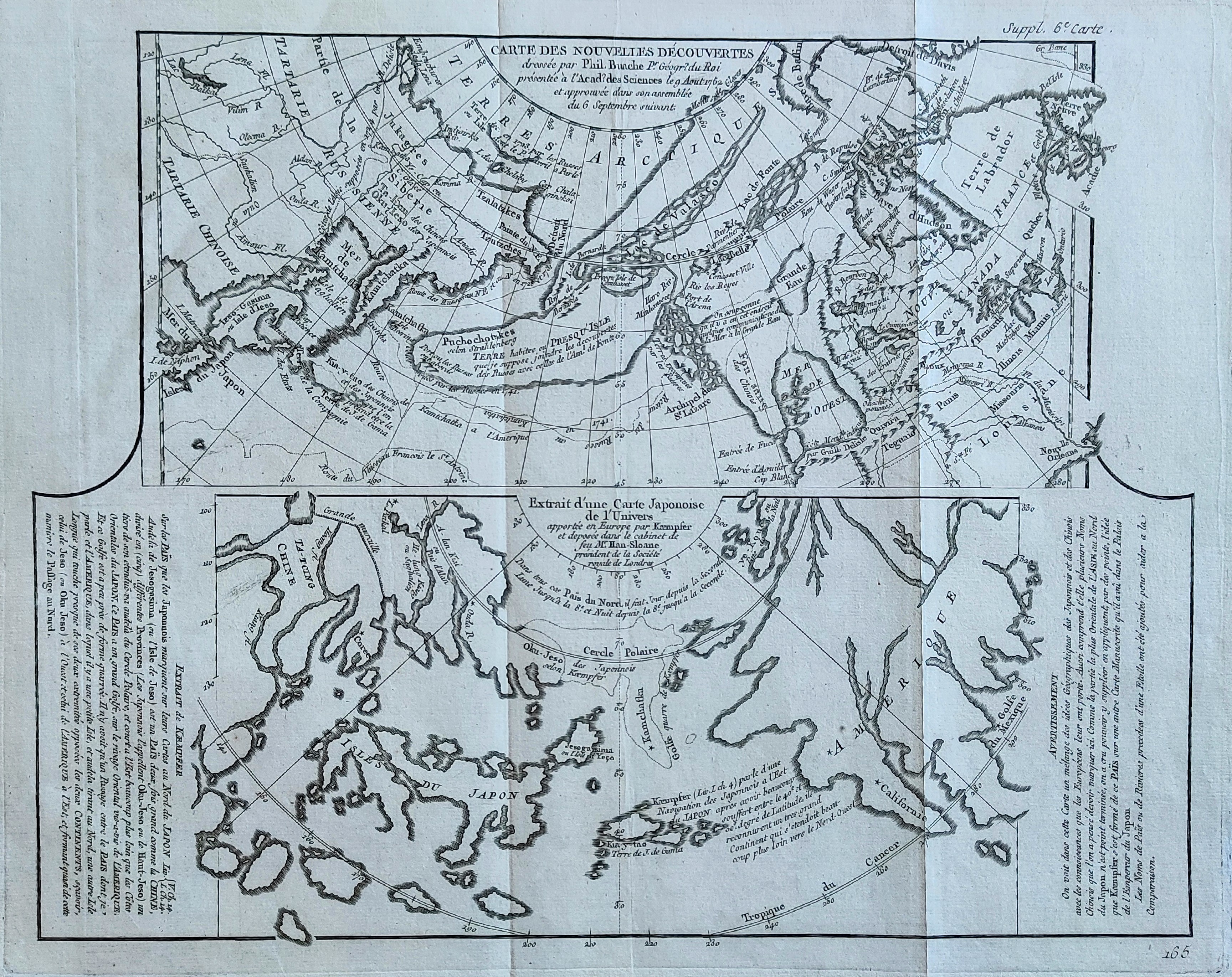
Map title
Carte des nouvelles decouvertes
Author
Diderot
Location shown in map
North America
Edition date
1772
Edition place
Paris
Editor
--
Atlas
Encyclopedie -- De Vaugondy
Price
125 Euro
State
[mint/EXCELLENT/very good/good/fair/mediocre/poor]
Color
Black/white
Verso
Blank
Size
Plate: cm (40.6 x 31.8) inches (15.98 x 12.52) Paper: cm (50.8 x 40.6) inches (20 x 15.98)
Technique
Copper engraving
Note
No particular notes for this maps
Reference
--
Wiki
Here for more info
In stock
Available
Info
info@thetreasuremaps.com
Code
#0081
×
![Carte des nouvelles decouvertes by Diderot, North America, 1772]()
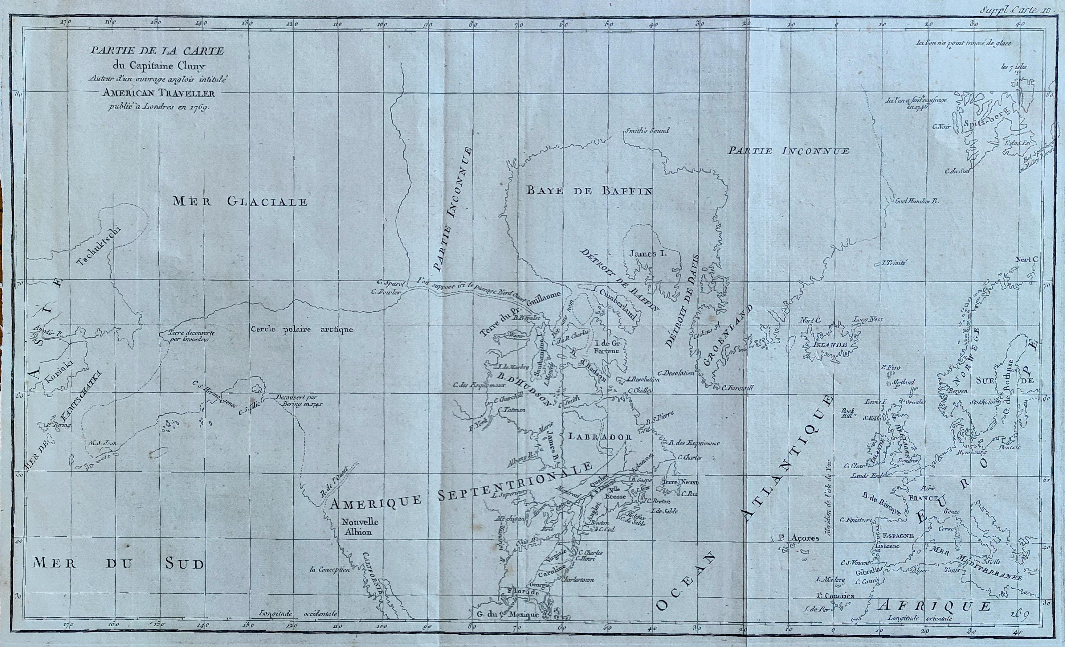
Map title
Partie de la carte du Capitaine Cluny
Author
Diderot
Location shown in map
North America
Edition date
1772
Edition place
Paris
Editor
Diderot
Atlas
Encyclopedie -- De Vaugondy
Price
250 Euro
State
[mint/EXCELLENT/very good/good/fair/mediocre/poor]
Color
Black/white
Verso
Blank
Size
Plate: cm (49.5 x 29.2) inches (19.49 x 11.5) Paper: cm (52 x 38) inches (20.47 x 14.96)
Technique
Copper engraving
Note
No particular notes for this maps
Reference
--
Wiki
Here for more info
In stock
Available
Info
info@thetreasuremaps.com
Code
#0082
×
![Partie de la carte du Capitaine Cluny by Diderot, North America, 1772]()
Map title
Carte des nouvelles decouvertes
Author
Diderot
Location shown in map
North America
Edition date
1772
Edition place
Paris
Editor
--
Atlas
Encyclopedie -- De Vaugondy
Price
125 Euro
State
[mint/EXCELLENT/very good/good/fair/mediocre/poor]
Color
Black/white
Verso
Blank
Size
Plate: cm (40.6 x 31.8) inches (15.98 x 12.52) Paper: cm (50.8 x 40.6) inches (20 x 15.98)
Technique
Copper engraving
Note
No particular notes for this maps
Reference
--
Wiki
Here for more info
In stock
Available
Info
info@thetreasuremaps.com
Code
#0910
×
![Carte des nouvelles decouvertes by Diderot, North America, 1772]()
Map title
Nouvelle Representation Des Cotes Nord et Est De L'Asie, pour servir ... Articles du Supplement de l'Encyclopedie qui concerent le Passage aux Indes par le Nord … 1772
Author
Diderot
Location shown in map
Asia
Edition date
1772
Edition place
Paris
Editor
--
Atlas
Encyclopedie -- De Vaugondy
Price
100 Euro
State
[mint/EXCELLENT/very good/good/fair/mediocre/poor]
Color
Black/white
Verso
Blank
Size
Plate: cm (40.6 x 33) inches (15.98 x 12.99) Paper: cm (50.8 x 40.6) inches (20 x 15.98)
Technique
Copper engraving
Note
No particular notes for this maps
Reference
--
Wiki
Here for more info
In stock
Available
Info
info@thetreasuremaps.com
Code
#0274
×
![Nouvelle Representation Des Cotes Nord et Est De L'Asie, pour servir ... Articles du Supplement de l'Encyclopedie qui concerent le Passage aux Indes par le Nord … 1772 by Diderot, Asia, 1772]()