1700-1799
Map title
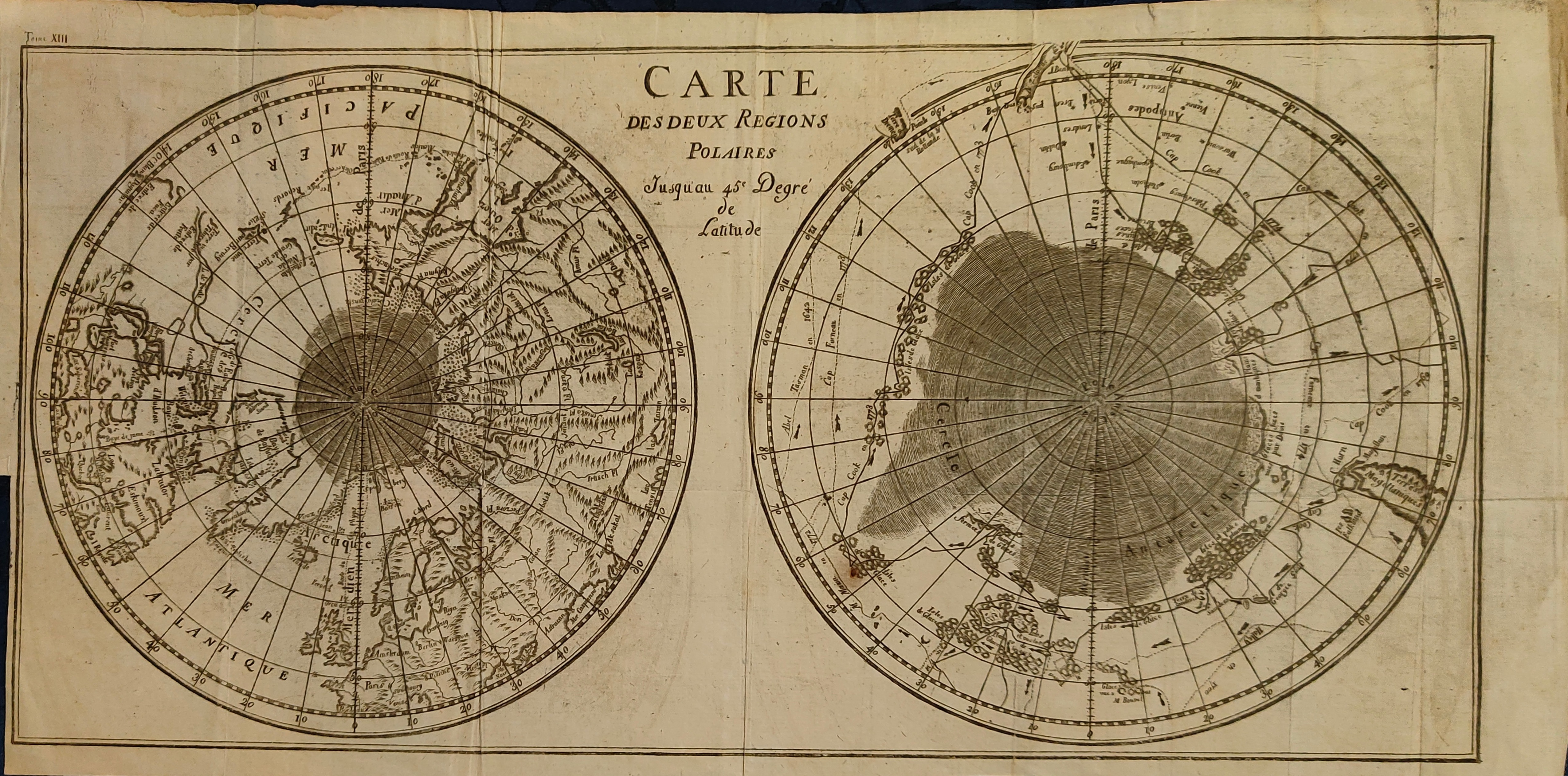
Carte Des Deux Regions Polaires
Author
Buffon
Location shown in map
Polar
Edition date
Circa 1778
Edition place
Paris
Editor
Atlas
Histoire naturelle, générale et particulière
Price
175 Euro
State
[mint/EXCELLENT/very good/good/fair/mediocre/poor]
Color
Black/white
Verso
Blank
Size
Plate: cm (44 x 22) inches (17.32 x 8.66) Paper: cm (47 x 24) inches (18.5 x 9.45)
Technique
Copper engraving
Note
Reference
Wiki
Here for more info
In stock
Available
Info
info@thetreasuremaps.com
Code
#1255
×
![Carte Des Deux Regions Polaires by Buffon, Polar, Circa 1778]()

Map title
Les isles Philippines...
Author
Bonne
Location shown in map
South East
Edition date
1780
Edition place
Paris
Editor
--
Atlas
Atlas de toutes les parties connues du globe terrestre. J.L.Pellet
Price
Please ask: info@thetreasuremaps.com
State
[mint/EXCELLENT/very good/good/fair/mediocre/poor]
Color
Black/white
Verso
Blank
Size
Plate: cm (31.8 x 21.6) inches (12.52 x 8.5) Paper: cm (36.8 x 25.4) inches (14.49 x 10)
Technique
Copper engraving
Note
No particular notes for this maps
Reference
--
Wiki
Here for more info
In stock
Sold
Info
info@thetreasuremaps.com
Code
#0439
×
![Les isles Philippines... by Bonne, South East, 1780]()
Map title
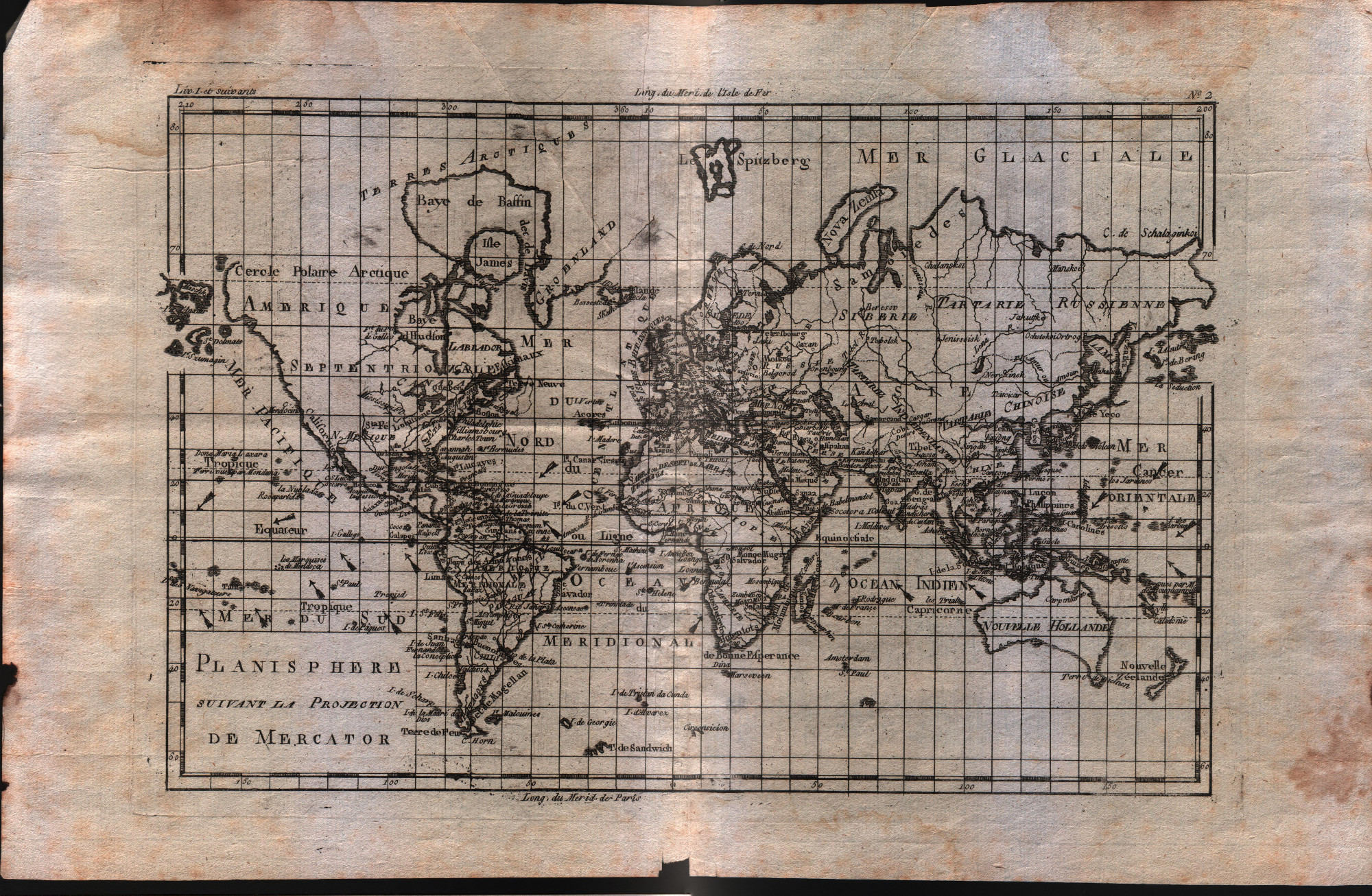
Planisphere suivant la projection de Mercator
Author
Bonne
Location shown in map
World
Edition date
1780
Edition place
Paris
Editor
--
Atlas
Atlas de toutes les parties connues du globe terrestre : dresse pour l'histoire philosophique et politique des alissemens et du commerce des europens dans les deux Indes. J.L.Pellet
Price
150 Euro
State
[mint/excellent/VERY GOOD/good/fair/mediocre/poor]
Color
Black/white
Verso
Blank
Size
Plate: cm (31.8 x 21) inches (12.52 x 8.27) Paper: cm (41.9 x 26.7) inches (16.5 x 10.51)
Technique
Copper engraving
Note
No particular notes for this maps
Reference
--
Wiki
Here for more info
In stock
Available
Info
info@thetreasuremaps.com
Code
#0582
×
![Planisphere suivant la projection de Mercator by Bonne, World, 1780]()
Map title
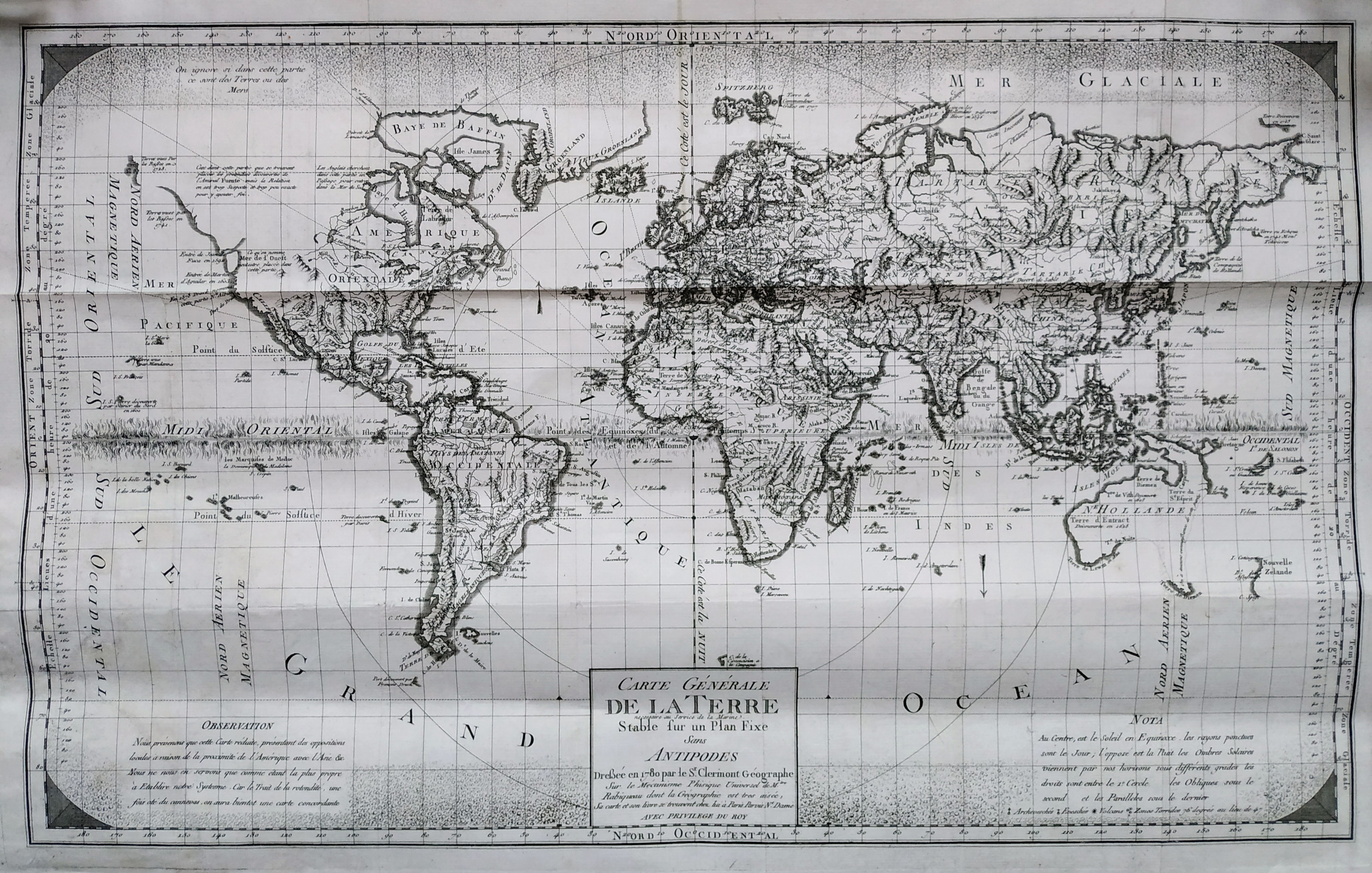
Carte Generale de la Terre necessaire au Service de la Marine Stable sur un Plan Fixe Sans Antipodes
Author
Clermont, Jacques
Location shown in map
World
Edition date
1780
Edition place
Paris
Editor
--
Atlas
Price
600 Euro
State
[mint/EXCELLENT/very good/good/fair/mediocre/poor]
Color
Black/white
Verso
Blank
Size
Plate: cm (58 x 36) inches (22.83 x 14.17) Paper: cm (63 x 48) inches (24.8 x 18.9)
Technique
Copper engraving
Note
No particular notes for this maps.
Reference
--
Wiki
Here for more info
In stock
Sold
Info
info@thetreasuremaps.com
Code
#0723
×
![Carte Generale de la Terre necessaire au Service de la Marine Stable sur un Plan Fixe Sans Antipodes by Clermont, Jacques, World, 1780]()
Map title
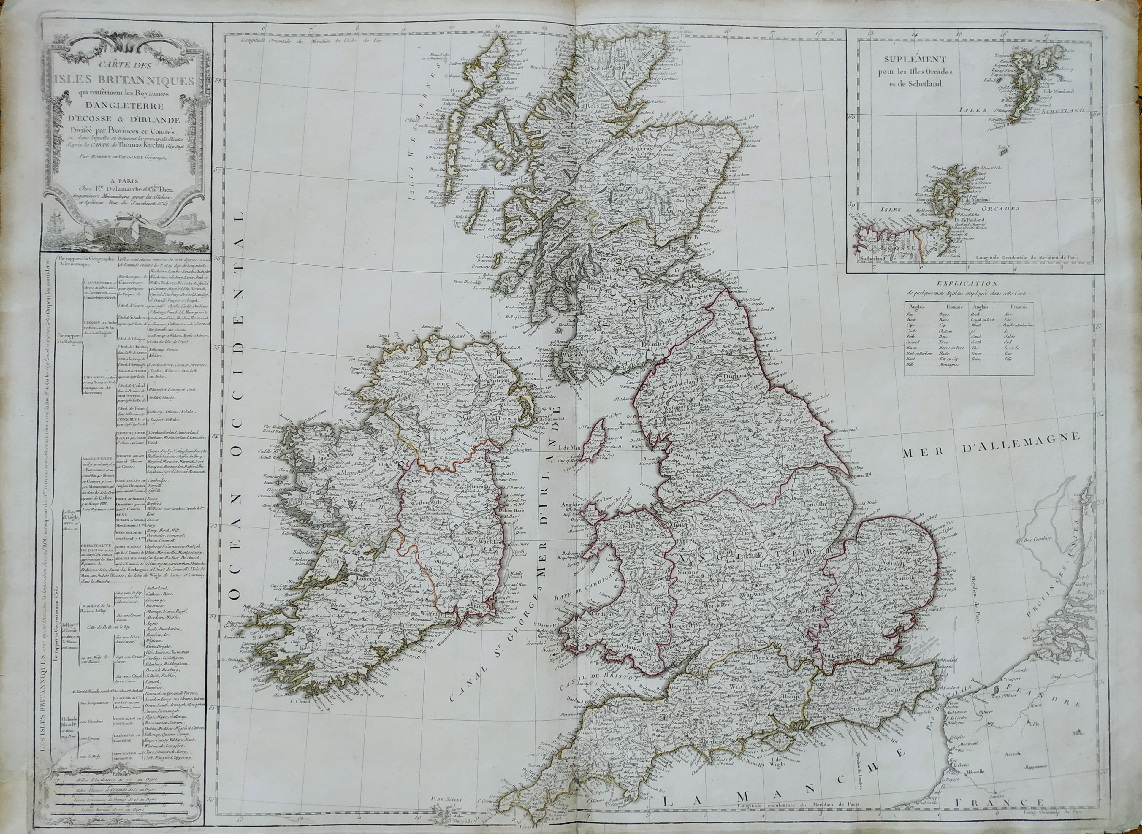
Cartes des isles Britanniques
Author
Robert de Vaugondy
Location shown in map
British Isles
Edition date
Circa 1780
Edition place
Paris
Editor
Delamarche
Atlas
Atlas d Etude pour l'instruction de la Jeunesse
Price
Please ask: info@thetreasuremaps.com
State
[mint/excellent/VERY GOOD/good/fair/mediocre/poor]
Color
Old color
Verso
Blank
Size
Plate: cm (71 x 53) inches (27.95 x 20.87) Paper: cm (77 x 57) inches (30.31 x 22.44)
Technique
Copper engraving
Note
Professionally rapaired
Reference
--
Wiki
Here for more info
In stock
Available
Info
info@thetreasuremaps.com
Code
#0744
×
![Cartes des isles Britanniques by Robert de Vaugondy, British Isles, Circa 1780]()
Map title
L'Italie Divisee en ses differents Etats Royaumes
Author
Citoyen Berthelon
Location shown in map
Italy
Edition date
Circa 1780
Edition place
Paris
Editor
--
Atlas
Atlas moderne
Price
100 Euro
State
[mint/EXCELLENT/very good/good/fair/mediocre/poor]
Color
Old colors
Verso
Blank
Size
Plate: cm (22 x 18) inches (8.66 x 7.09) Paper: cm (24 x 20) inches (9.45 x 7.87)
Technique
Copper engraving
Note
Reference
--
Wiki
Here for more info
In stock
Available
Info
info@thetreasuremaps.com
Code
#0902
×
![L'Italie Divisee en ses differents Etats Royaumes by Citoyen Berthelon, Italy, Circa 1780]()
Map title
Gli stati d'Italia
Author
Probst
Location shown in map
Italy
Edition date
1780
Edition place
Augsburg
Editor
Atlas
Atlas Selectus
Price
175 Euro
State
[mint/excellent/VERY GOOD/good/fair/mediocre/poor]
Color
Old colors
Verso
Blank
Size
Plate: cm (25 x 17) inches (9.84 x 6.69) Paper: cm (33 x 21) inches (12.99 x 8.27)
Technique
Copper engraving
Note
Reference
R.Borri L'Italia nelle antiche carte pag.202
Wiki
Here for more info
In stock
Available
Info
info@thetreasuremaps.com
Code
#0966
×
![Gli stati d'Italia by Probst, Italy, 1780]()
Map title
L'Italie divisee en ses different ...
Author
Janvier
Location shown in map
Italy
Edition date
1780
Edition place
Venice
Editor
Santini
Atlas
Atlas Universel
Price
350 Euro
State
[mint/excellent/VERY GOOD/good/fair/mediocre/poor]
Color
Old colors
Verso
Blank
Size
Plate: cm (64 x 48) inches (25.2 x 18.9) Paper: cm (72 x 55) inches (28.35 x 21.65)
Technique
Copper engraving
Note
Reference
R.Borri L'Italia nelle antiche carte pag.255
Wiki
Here for more info
In stock
Available
Info
info@thetreasuremaps.com
Code
#1017
×
![L'Italie divisee en ses different ... by Janvier, Italy, 1780]()
Map title
L'Italie divisee en ses different ...
Author
Janvier
Location shown in map
Italy
Edition date
1780
Edition place
Venice
Editor
Santini
Atlas
Atlas Universel
Price
350 Euro
State
[mint/excellent/VERY GOOD/good/fair/mediocre/poor]
Color
Old colors
Verso
Blank
Size
Plate: cm (64 x 48) inches (25.2 x 18.9) Paper: cm (72 x 55) inches (28.35 x 21.65)
Technique
Copper engraving
Note
Reference
R.Borri L'Italia nelle antiche carte pag.255
Wiki
Here for more info
In stock
Available
Info
info@thetreasuremaps.com
Code
#1057
×
![L'Italie divisee en ses different ... by Janvier, Italy, 1780]()
Map title
Tabula Italiae antiquae
Author
De L'Isle
Location shown in map
Italy
Edition date
Circa 1780
Edition place
Paris
Editor
Dezauche
Atlas
Price
300 Euro
State
[mint/EXCELLENT/very good/good/fair/mediocre/poor]
Color
Old colors
Verso
Blank
Size
Plate: cm (64 x 50) inches (25.2 x 19.69) Paper: cm (81 x 57) inches (31.89 x 22.44)
Technique
Copper engraving
Note
Reference
Wiki
Here for more info
In stock
Available
Info
info@thetreasuremaps.com
Code
#1248
×
![Tabula Italiae antiquae by De L'Isle, Italy, Circa 1780]()
Map title
Carte Geo-Hydrographique du golfe du Mexico
Author
Rizzi Zannoni
Location shown in map
West Indies
Edition date
Circa 1780
Edition place
Paris
Editor
Atlas
Price
300 Euro
State
[mint/EXCELLENT/very good/good/fair/mediocre/poor]
Color
Old colors
Verso
Blank
Size
Plate: cm (45 x 31) inches (17.72 x 12.2) Paper: cm (54 x 39) inches (21.26 x 15.35)
Technique
Copper engraving
Note
Reference
Wiki
Here for more info
In stock
Available
Info
info@thetreasuremaps.com
Code
#1263
×
![Carte Geo-Hydrographique du golfe du Mexico by Rizzi Zannoni, West Indies, Circa 1780]()
Map title
Carte de la Coree et du Japon
Author
Brion de la Tour
Location shown in map
Japan
Edition date
Circa 1780
Edition place
Paris
Editor
Atlas
Price
200 Euro
State
[mint/EXCELLENT/very good/good/fair/mediocre/poor]
Color
Black/white
Verso
Blank
Size
Plate: cm (35 x 24) inches (13.78 x 9.45) Paper: cm (38 x 27) inches (14.96 x 10.63)
Technique
Copper engraving
Note
Reference
Wiki
Here for more info
In stock
Available
Info
info@thetreasuremaps.com
Code
#1322
×
![Carte de la Coree et du Japon by Brion de la Tour, Japan, Circa 1780]()
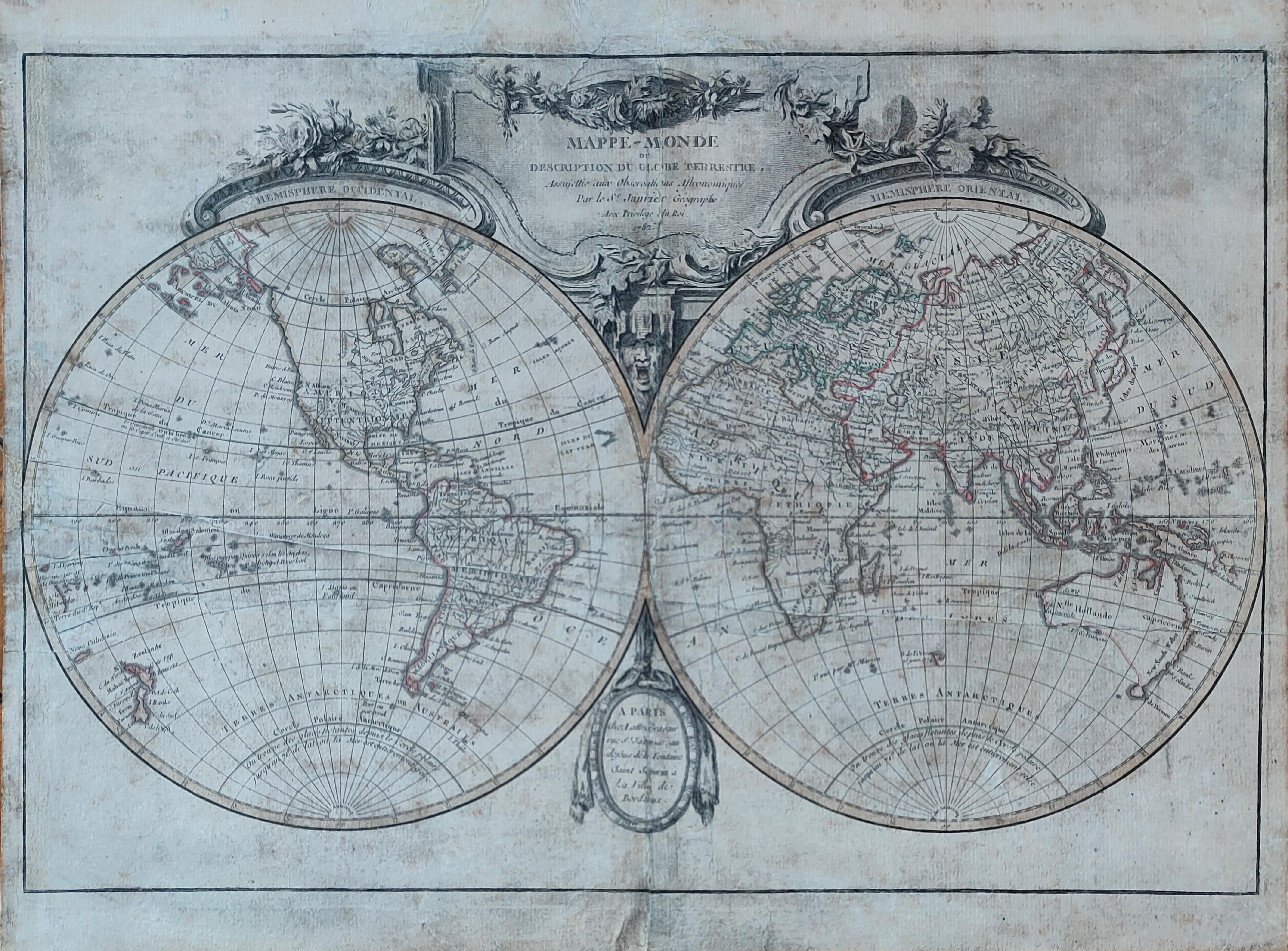
Map title
Mappe-monde
Author
Janvier
Location shown in map
World
Edition date
1782
Edition place
Paris
Editor
Lattre
Atlas
Price
400 Euro
State
[mint/excellent/VERY GOOD/good/fair/mediocre/poor]
Color
Old colors
Verso
Blank
Size
Plate: cm (45 x 31) inches (17.72 x 12.2) Paper: cm (47 x 35) inches (18.5 x 13.78)
Technique
Copper engraving
Note
Reference
Wiki
Here for more info
In stock
Available
Info
info@thetreasuremaps.com
Code
#1159
×
![Mappe-monde by Janvier, World, 1782]()
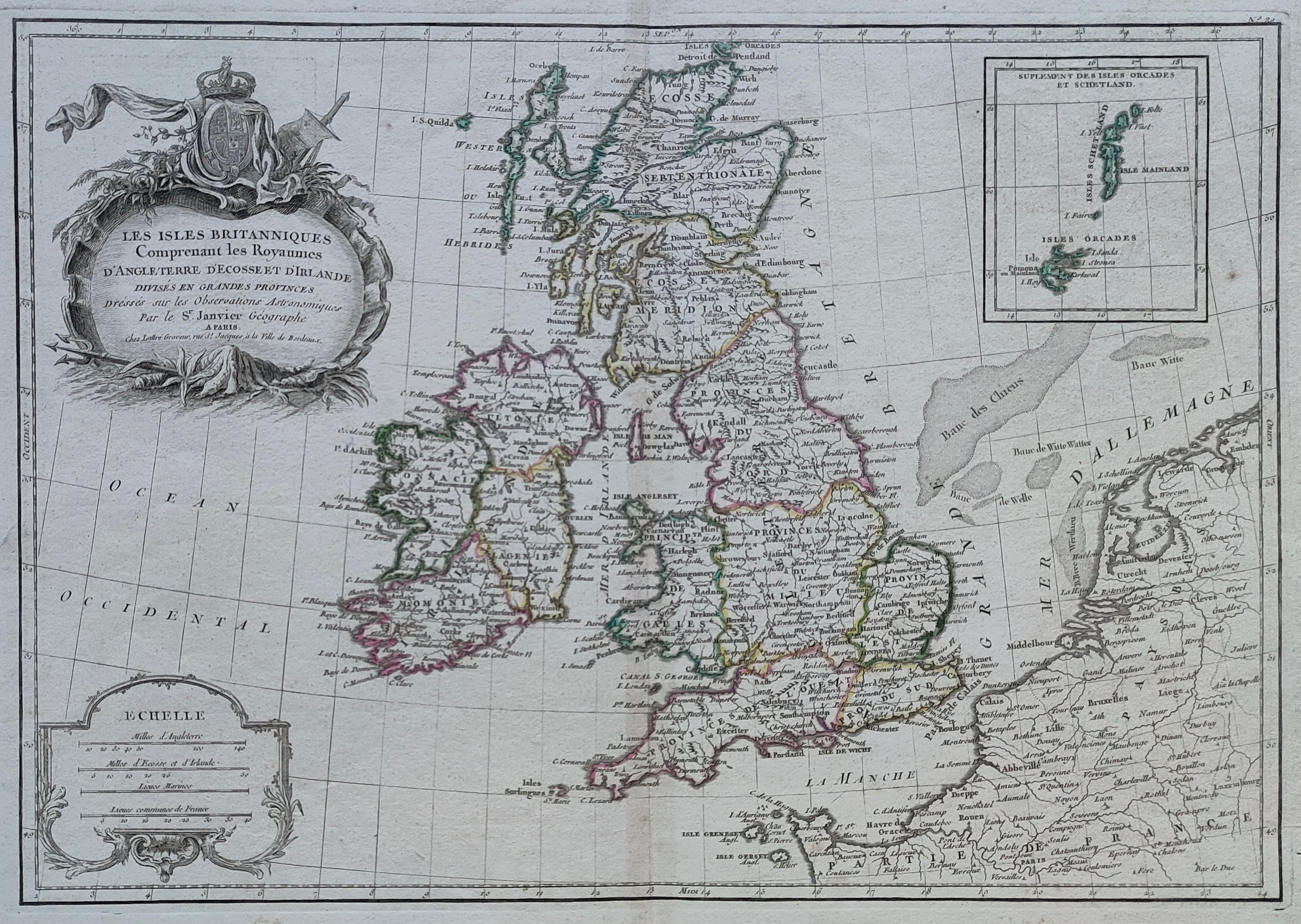
Map title
Les isles Britanniques
Author
Janvier
Location shown in map
British Isles
Edition date
Circa 1782
Edition place
Paris
Editor
Atlas
Price
150 Euro
State
[mint/EXCELLENT/very good/good/fair/mediocre/poor]
Color
Old colors
Verso
Blank
Size
Plate: cm (44 x 31) inches (17.32 x 12.2) Paper: cm (50 x 37) inches (19.69 x 14.57)
Technique
Copper engraving
Note
Reference
Wiki
Here for more info
In stock
Available
Info
info@thetreasuremaps.com
Code
#1216
×
![Les isles Britanniques by Janvier, British Isles, Circa 1782]()
Map title
Mappe-monde
Author
Janvier
Location shown in map
World
Edition date
1782
Edition place
Paris
Editor
Lattre
Atlas
Price
400 Euro
State
[mint/excellent/VERY GOOD/good/fair/mediocre/poor]
Color
Old colors
Verso
Hand written
Size
Plate: cm (45 x 30) inches (17.72 x 11.81) Paper: cm (47 x 35) inches (18.5 x 13.78)
Technique
Copper engraving
Note
Professonally restored
Reference
Wiki
Here for more info
In stock
Available
Info
info@thetreasuremaps.com
Code
#1262
×
![Mappe-monde by Janvier, World, 1782]()

Map title
Terra di Bari e Basilicata
Author
Zatta
Location shown in map
Puglia
Edition date
1783
Edition place
Venice
Editor
Atlas
Atlante novissimo
Price
200 Euro
State
[mint/EXCELLENT/very good/good/fair/mediocre/poor]
Color
Old colors
Verso
Blank
Size
Plate: cm (42 x 32) inches (16.54 x 12.6) Paper: cm (47 x 37) inches (18.5 x 14.57)
Technique
Copper engraving
Note
Reference
Wiki
Here for more info
In stock
Available
Info
info@thetreasuremaps.com
Code
#1295
×
![Terra di Bari e Basilicata by Zatta, Puglia, 1783]()
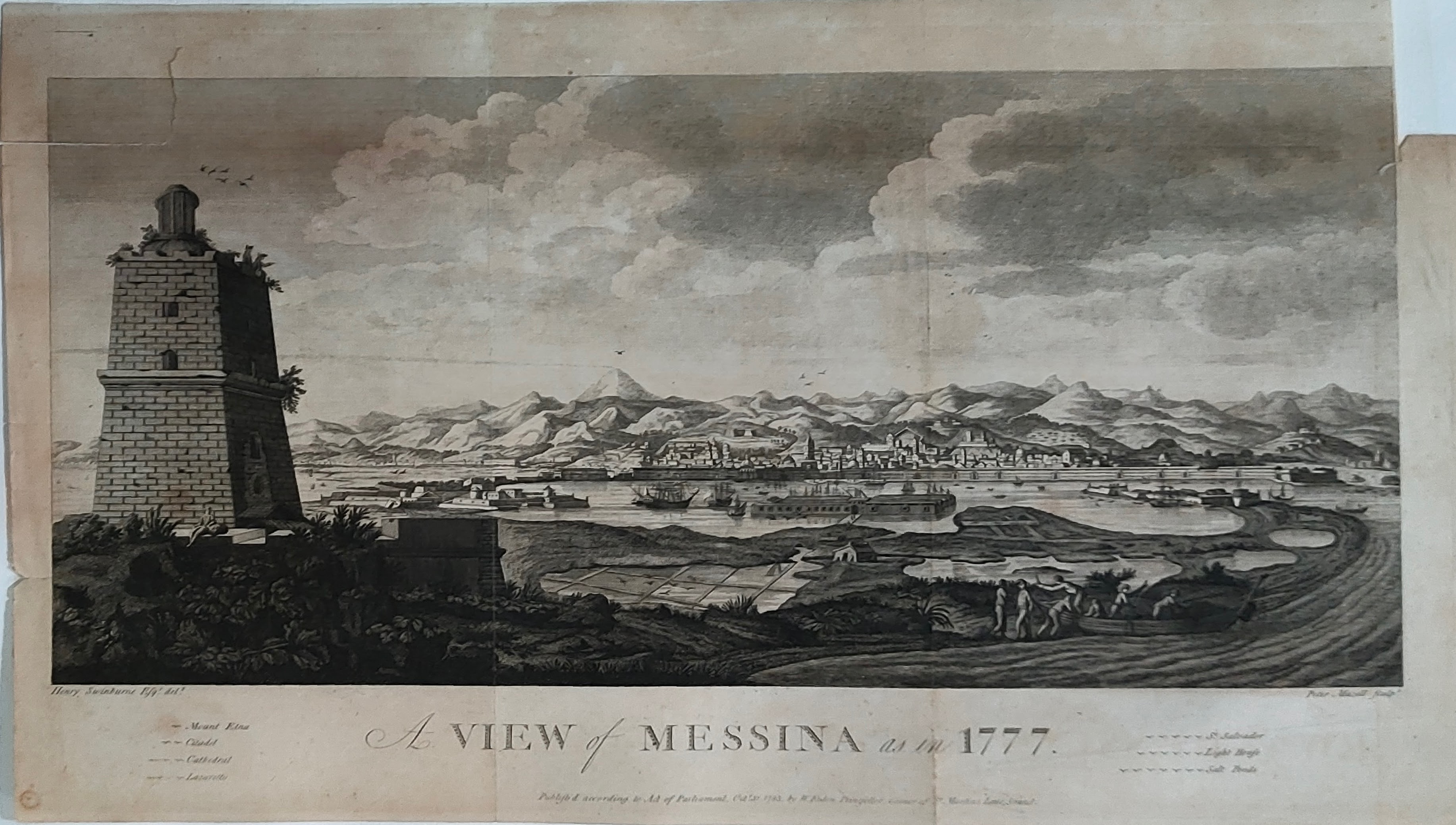
Map title
A view of Messina
Author
Mazell
Location shown in map
Messina
Edition date
1783
Edition place
London
Editor
Atlas
Travels in the two Sicilies
Price
450 Euro
State
[mint/EXCELLENT/very good/good/fair/mediocre/poor]
Color
Black/white
Verso
Blank
Size
Plate: cm (53 x 26) inches (20.87 x 10.24) Paper: cm (58 x 34) inches (22.83 x 13.39)
Technique
Copper engraving
Note
Reference
Wiki
Here for more info
In stock
Available
Info
info@thetreasuremaps.com
Code
#1314
×
![A view of Messina by Mazell, Messina, 1783]()
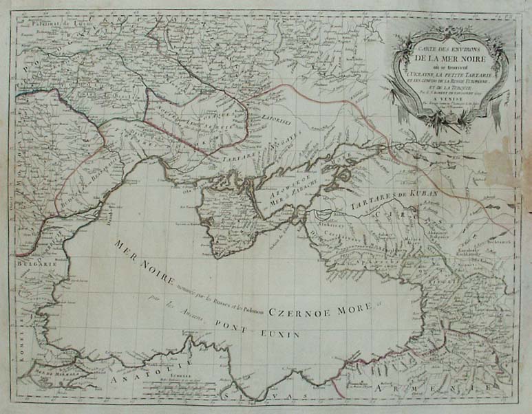
Map title
Carte des environs de la mer Noire o se trouvent l'Ukraine, la petite Tartarie, et les confins de la Russie Europine, et de la Turquie
Author
Unknown
Location shown in map
--
Edition date
1784
Edition place
Venise
Editor
--
Atlas
Atlas Universel dresse sur les meilleures cartes modernes. Printed by Santini & Remondini.
Price
Please ask: info@thetreasuremaps.com
State
[mint/excellent/very good/good/fair/MEDIOCRE/poor] the map is damaged.
Color
Old outlined
Verso
Blank
Size
Plate: cm (48.3 x 63.5) inches (19.02 x 25) Paper: cm (54.6 x 76.2) inches (21.5 x 30)
Technique
Copper engraving
Note
The atlas is effectively an Italian copy of the Robert de Vaugondy Atlas Universel, and contains 123 maps, variously dated 1775 to 1780. The atlas was reprinted in 1784 by Remondini, which gives a relatively short career span for Santini.
Reference
--
Wiki
Here for more info
In stock
Available
Info
info@thetreasuremaps.com
Code
#0277
×
![Carte des environs de la mer Noire o se trouvent l'Ukraine, la petite Tartarie, et les confins de la Russie Europine, et de la Turquie by Unknown, --, 1784]()
Map title
Turquie d'Europe
Author
Unknown
Location shown in map
--
Edition date
1784
Edition place
Venise
Editor
--
Atlas
Atlas Universel dresse sur les meilleures cartes modernes. Printed by Santini & Remondini.
Price
Please ask: info@thetreasuremaps.com
State
[mint/EXCELLENT/very good/good/fair/mediocre/poor]
Color
Old outlined
Verso
Blank
Size
Plate: cm (48.3 x 63.5) inches (19.02 x 25) Paper: cm (54.6 x 71.1) inches (21.5 x 27.99)
Technique
Copper engraving
Note
The atlas is effectively an Italian copy of the Robert de Vaugondy Atlas Universel, and contains 123 maps, variously dated 1775 to 1780. The atlas was reprinted in 1784 by Remondini, which gives a relatively short career span for Santini.
Reference
--
Wiki
Here for more info
In stock
Sold
Info
info@thetreasuremaps.com
Code
#0440
×
![Turquie d'Europe by Unknown, --, 1784]()
Map title
Royaume de Hongrie
Author
Unknown
Location shown in map
Hungary
Edition date
1784
Edition place
Venise
Editor
--
Atlas
Atlas Universel dresse sur les meilleures cartes modernes. Printed by Santini & Remondini.
Price
Please ask: info@thetreasuremaps.com
State
[mint/EXCELLENT/very good/good/fair/mediocre/poor]
Color
Old outlined
Verso
Blank
Size
Plate: cm (48.3 x 68.6) inches (19.02 x 27.01) Paper: cm (54.6 x 76.2) inches (21.5 x 30)
Technique
Copper engraving
Note
The atlas is effectively an Italian copy of the Robert de Vaugondy Atlas Universel, and contains 123 maps, variously dated 1775 to 1780. The atlas was reprinted in 1784 by Remondini, which gives a relatively short career span for Santini.
Reference
--
Wiki
Here for more info
In stock
Sold
Info
info@thetreasuremaps.com
Code
#0442
×
![Royaume de Hongrie by Unknown, Hungary, 1784]()