1700-1799
Map title
Africa
Author
Magini
Location shown in map
Africa
Edition date
1713
Edition place
Padua
Editor
Cadorin
Atlas
Universus terrarum orbis scriptorum calamo delineatus
Price
300 Euro
State
[MINT/excellent/very good/good/fair/mediocre/poor]
Color
Black/white
Verso
Latin text pag.22
Size
Plate: cm (17.8 x 12.7) inches (7.01 x 5) Paper: cm (20.3 x 30.5) inches (7.99 x 12.01)
Technique
Copper engraving
Note
Alphonse Lasor a Varea
Reference
--
Wiki
Here for more info
In stock
Available
Info
info@thetreasuremaps.com
Code
#0595
Africa
Author
Magini
Location shown in map
Africa
Edition date
1713
Edition place
Padua
Editor
Cadorin
Atlas
Universus terrarum orbis scriptorum calamo delineatus
Price
300 Euro
State
[MINT/excellent/very good/good/fair/mediocre/poor]
Color
Black/white
Verso
Latin text pag.22
Size
Plate: cm (17.8 x 12.7) inches (7.01 x 5) Paper: cm (20.3 x 30.5) inches (7.99 x 12.01)
Technique
Copper engraving
Note
Alphonse Lasor a Varea
Reference
--
Wiki
Here for more info
In stock
Available
Info
info@thetreasuremaps.com
Code
#0595
×
![Africa by Magini, Africa, 1713]()
Map title
America
Author
Magini
Location shown in map
Americas
Edition date
1713
Edition place
Padua
Editor
Cadorin
Atlas
Universus terrarum orbis scriptorum calamo delineatus
Price
400 Euro
State
[MINT/excellent/very good/good/fair/mediocre/poor]
Color
Modern color
Verso
Latin text pag.22
Size
Plate: cm (17.8 x 12.7) inches (7.01 x 5) Paper: cm (23 x 34) inches (9.06 x 13.39)
Technique
Copper engraving
Note
Alphonse Lasor a Varea
Reference
--
Wiki
Here for more info
In stock
Available
Info
info@thetreasuremaps.com
Code
#0835
×
![America by Magini, Americas, 1713]()
Map title
L'Italie suivant les nouvelles Observations
Author
Vander
Location shown in map
Italy
Edition date
Circa 1714
Edition place
Leide
Editor
Atlas
Atlas tres exact et fort commode put toutes
Price
200 Euro
State
[mint/EXCELLENT/very good/good/fair/mediocre/poor]
Color
Black/white
Verso
Blank
Size
Plate: cm (29 x 22) inches (11.42 x 8.66) Paper: cm (34 x 24) inches (13.39 x 9.45)
Technique
Copper engraving
Note
Reference
R.Borri L'Italia nelle antiche carte pag.218
Wiki
Here for more info
In stock
Available
Info
info@thetreasuremaps.com
Code
#1378
×
![L'Italie suivant les nouvelles Observations by Vander, Italy, Circa 1714]()
Map title
A New Map of Italy, Distinguishing all the
Author
Moll
Location shown in map
Italy
Edition date
1714
Edition place
London
Editor
Atlas
New and compleat atlas
Price
Please ask: info@thetreasuremaps.com
State
[mint/excellent/VERY GOOD/good/fair/mediocre/poor]
Color
Old colors
Verso
Blank
Size
Plate: cm (102 x 61) inches (40.16 x 24.02) Paper: cm (100 x 59) inches (39.37 x 23.23)
Technique
Copper engraving
Note
Reference
R.Borri L'Italia nelle antiche carte pag.231
Wiki
Here for more info
In stock
Available
Info
info@thetreasuremaps.com
Code
#0951
×
![A New Map of Italy, Distinguishing all the by Moll, Italy, 1714]()

Map title
Totius regni Neapolis
Author
Homann
Location shown in map
South Italy
Edition date
Circa 1716
Edition place
Nurimberg
Editor
Atlas
Price
400 Euro
State
[mint/EXCELLENT/very good/good/fair/mediocre/poor]
Color
Old colors
Verso
Blank
Size
Plate: cm (51 x 60) inches (20.08 x 23.62) Paper: cm (48 x 56) inches (18.9 x 22.05)
Technique
Copper engraving
Note
framed
Reference
--
Wiki
Here for more info
In stock
Available
Info
info@thetreasuremaps.com
Code
#1227
×
![Totius regni Neapolis by Homann, South Italy, Circa 1716]()
Map title
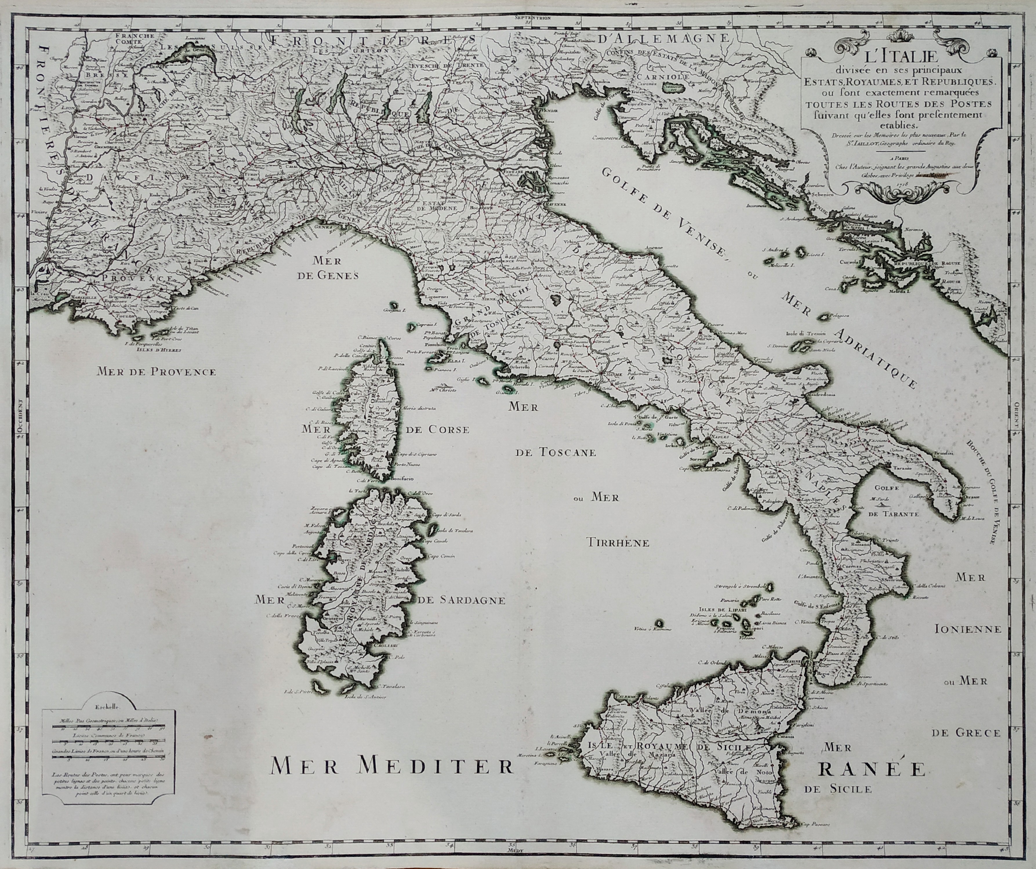
L'Italie divisee en ses principaux Estats
Author
Alexis Hubert Jaillot
Location shown in map
Italy
Edition date
1718
Edition place
Paris
Editor
Atlas
Price
300 Euro
State
[mint/excellent/VERY GOOD/good/fair/mediocre/poor]
Color
Old color
Verso
Blank
Size
Plate: cm (74 x 53) inches (29.13 x 20.87) Paper: cm (60 x 51) inches (23.62 x 20.08)
Technique
Copper engraving
Note
Reference
R.Borri L'Italia nelle antiche carte pag.187
Wiki
Here for more info
In stock
Available
Info
info@thetreasuremaps.com
Code
#0760
×
![L'Italie divisee en ses principaux Estats by Alexis Hubert Jaillot, Italy, 1718]()
Map title
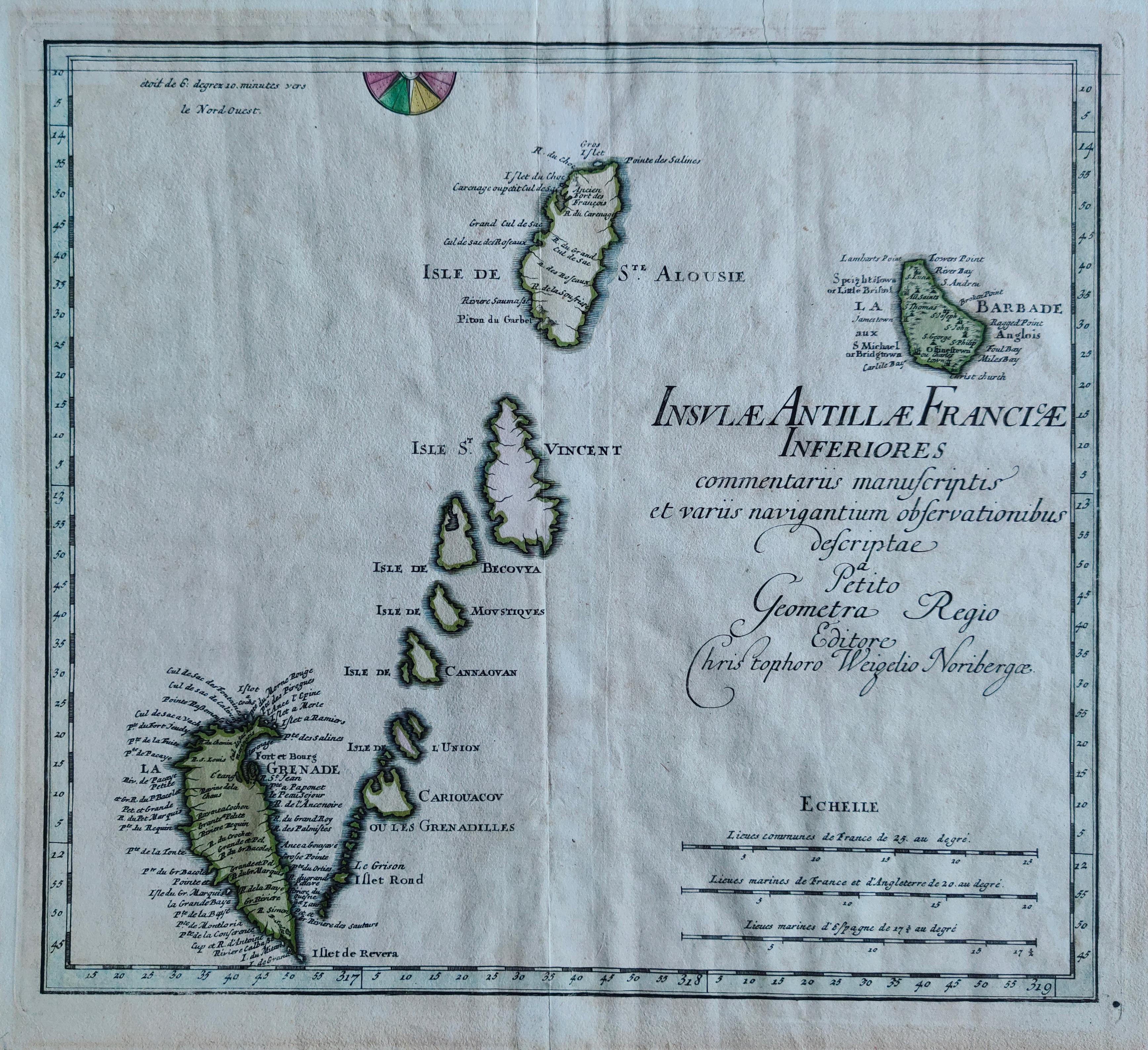
Insulae Antillae Franciae Inferiores
Author
Weigel
Location shown in map
Antille
Edition date
1719
Edition place
Nurimberg
Editor
Atlas
Schul- und Reisen-Atlas Aller Zu Erlernung der Alten
Price
275 Euro
State
[mint/EXCELLENT/very good/good/fair/mediocre/poor]
Color
Old colors
Verso
Blank
Size
Plate: cm (36 x 32) inches (14.17 x 12.6) Paper: cm (40 x 36) inches (15.75 x 14.17)
Technique
Copper engraving
Note
Reference
Wiki
Here for more info
In stock
Available
Info
info@thetreasuremaps.com
Code
#1284
×
![Insulae Antillae Franciae Inferiores by Weigel, Antille, 1719]()
Map title
Carte du gouvernment civil et miltaire avec l'etat des officiers du royaume d'Irlande
Author
Henri Chatelain
Location shown in map
Irland
Edition date
1719
Edition place
Amsterdam
Editor
Atlas
Atlas Historique
Price
200 Euro
State
[mint/EXCELLENT/very good/good/fair/mediocre/poor]
Color
Black/white
Verso
Blank
Size
Plate: cm (52 x 42) inches (20.47 x 16.54) Paper: cm (53 x 43) inches (20.87 x 16.93)
Technique
Copper engraving
Note
Reference
Wiki
Here for more info
In stock
Available
Info
info@thetreasuremaps.com
Code
#0825
×
![Carte du gouvernment civil et miltaire avec l'etat des officiers du royaume d'Irlande by Henri Chatelain, Irland, 1719]()
Map title
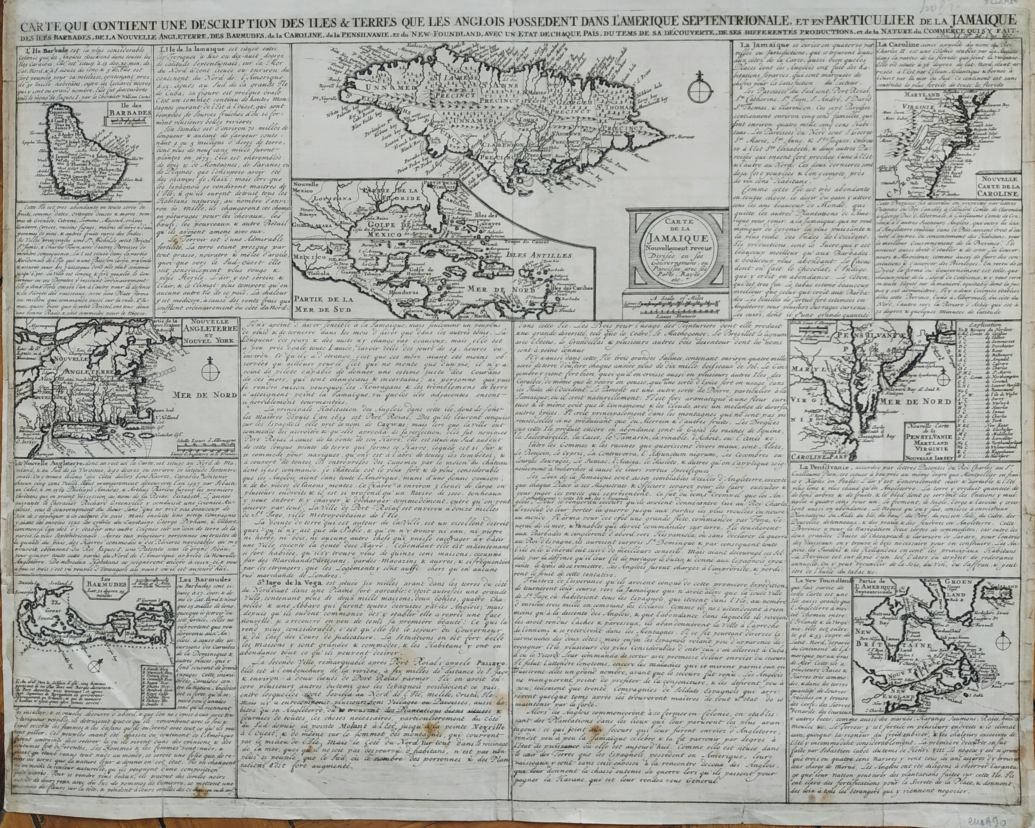
Carte qui contient une description des iles & terres que les Anglois possedent dans l'Amerique septentrionale, et en particulier de la Jamaique, des Iles Barbades, de la Nouvelle Angleterre, Des Barmudes,de la Caroline, de la Pensilvanie, et du New-Foundland, avec un Etat de Chaque Pais
Author
Henri Chatelain
Location shown in map
North America
Edition date
1719
Edition place
Amsterdam
Editor
Atlas
Atlas Historique
Price
200 Euro
State
[mint/excellent/VERY GOOD/good/fair/mediocre/poor]
Color
Black/white
Verso
Blank
Size
Plate: cm (52 x 42) inches (20.47 x 16.54) Paper: cm (53 x 43) inches (20.87 x 16.93)
Technique
Copper engraving
Note
Reference
Wiki
Here for more info
In stock
Available
Info
info@thetreasuremaps.com
Code
#0811
×
![Carte qui contient une description des iles & terres que les Anglois possedent dans l'Amerique septentrionale, et en particulier de la Jamaique, des Iles Barbades, de la Nouvelle Angleterre, Des Barmudes,de la Caroline, de la Pensilvanie, et du New-Foundland, avec un Etat de Chaque Pais by Henri Chatelain, North America, 1719]()
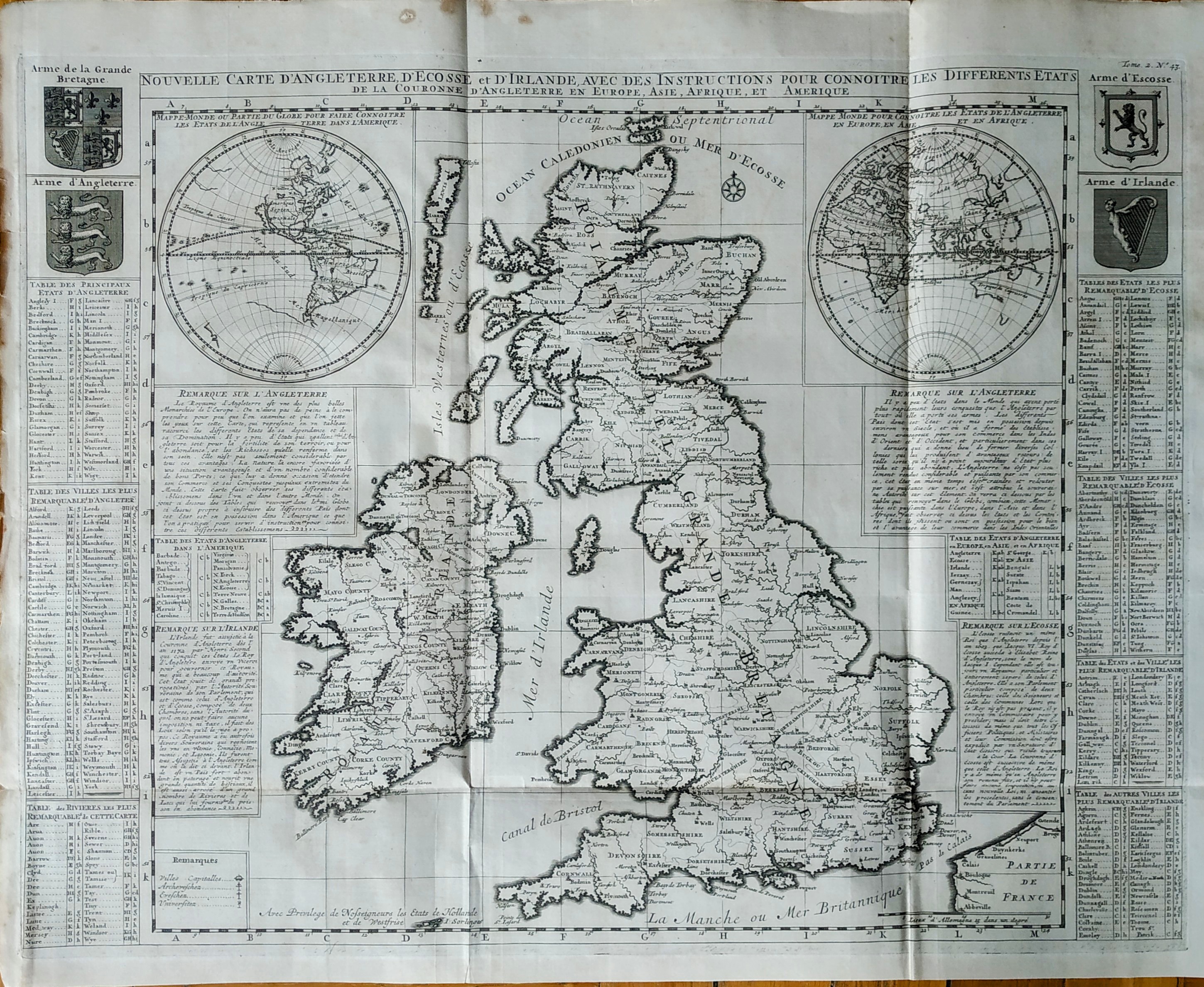
Map title
Nouvelle carte d'Angleterre d'Ecosse et d'Irlande
Author
Henri Chatelain
Location shown in map
Great Britain
Edition date
1719
Edition place
Amsterdam
Editor
Atlas
Atlas Historique
Price
350 Euro
State
[mint/EXCELLENT/very good/good/fair/mediocre/poor]
Color
Black/white
Verso
Blank
Size
Plate: cm (62 x 47) inches (24.41 x 18.5) Paper: cm (65 x 53) inches (25.59 x 20.87)
Technique
Copper engraving
Note
Reference
Wiki
Here for more info
In stock
Available
Info
info@thetreasuremaps.com
Code
#0813
×
![Nouvelle carte d'Angleterre d'Ecosse et d'Irlande by Henri Chatelain, Great Britain, 1719]()
Map title
Ducatus Sabaudiae Principatus Pedemontium et Ducatus Montisferratis
Author
Homann
Location shown in map
Piedmont
Edition date
Circa 1720
Edition place
Nuremberg
Editor
--
Atlas
--
Price
350 Euro
State
[mint/excellent/VERY GOOD/good/fair/mediocre/poor]
Color
Old colors
Verso
Blank
Size
Plate: cm (55.9 x 48.3) inches (22.01 x 19.02) Paper: cm (61 x 50.8) inches (24.02 x 20)
Technique
Copper engraving
Note
Framed
Reference
--
Wiki
Here for more info
In stock
Available
Info
info@thetreasuremaps.com
Code
#1098
×
![Ducatus Sabaudiae Principatus Pedemontium et Ducatus Montisferratis by Homann, Piedmont, Circa 1720]()
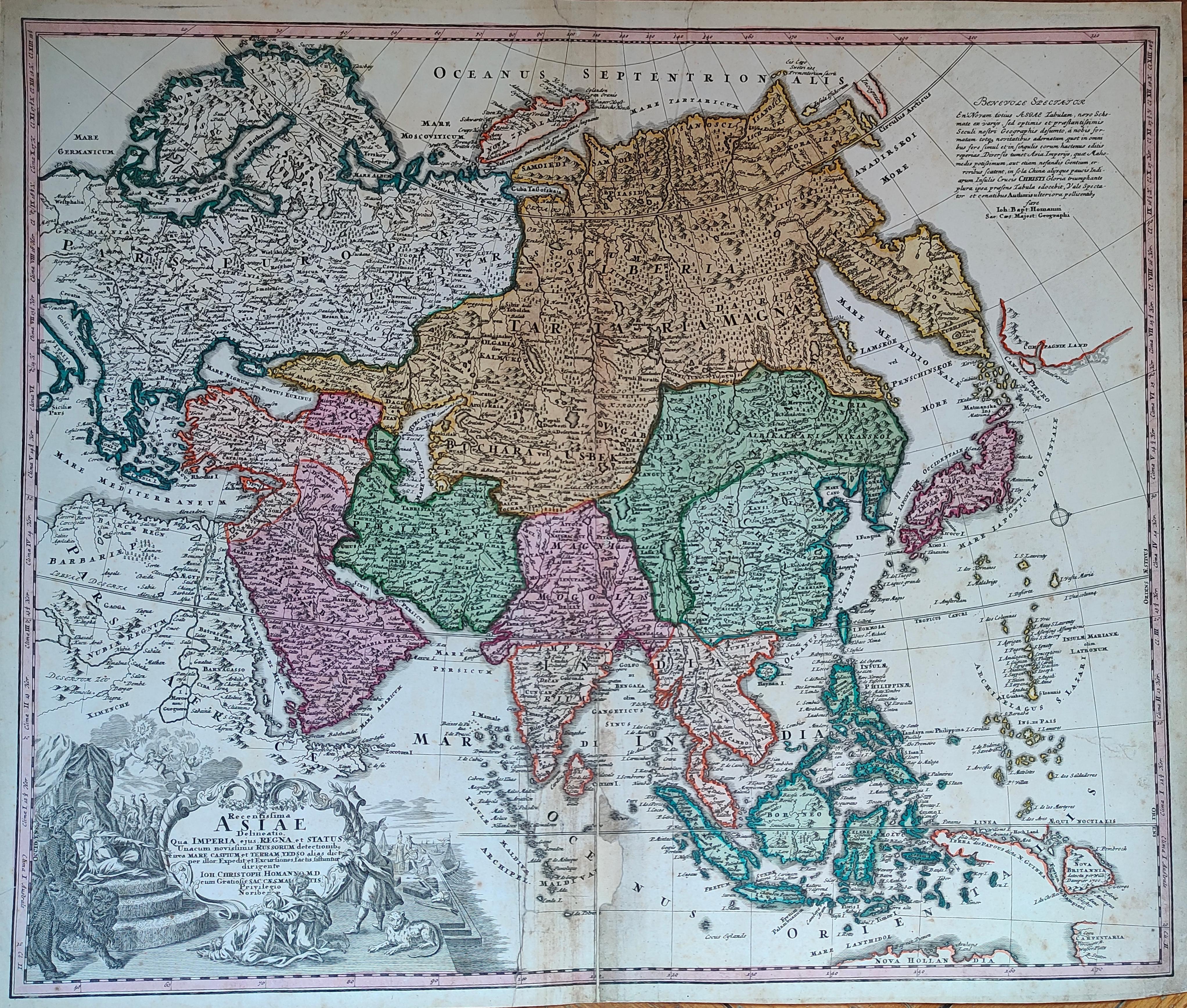
Map title
Asiae Recentissima Delineatio Qua Status et Imperia Totius Orientis unacum Orientalibus Indiis
Author
Homann
Location shown in map
Asia
Edition date
Circa 1720
Edition place
Nurimberg
Editor
--
Atlas
Price
400 Euro
State
[mint/excellent/VERY GOOD/good/fair/mediocre/poor]
Color
Old colors
Verso
Blank
Size
Plate: cm (58 x 48) inches (22.83 x 18.9) Paper: cm (59 x 52) inches (23.23 x 20.47)
Technique
Copper engraving
Note
Reference
Wiki
Here for more info
In stock
Available
Info
info@thetreasuremaps.com
Code
#1282
×
![Asiae Recentissima Delineatio Qua Status et Imperia Totius Orientis unacum Orientalibus Indiis by Homann, Asia, Circa 1720]()
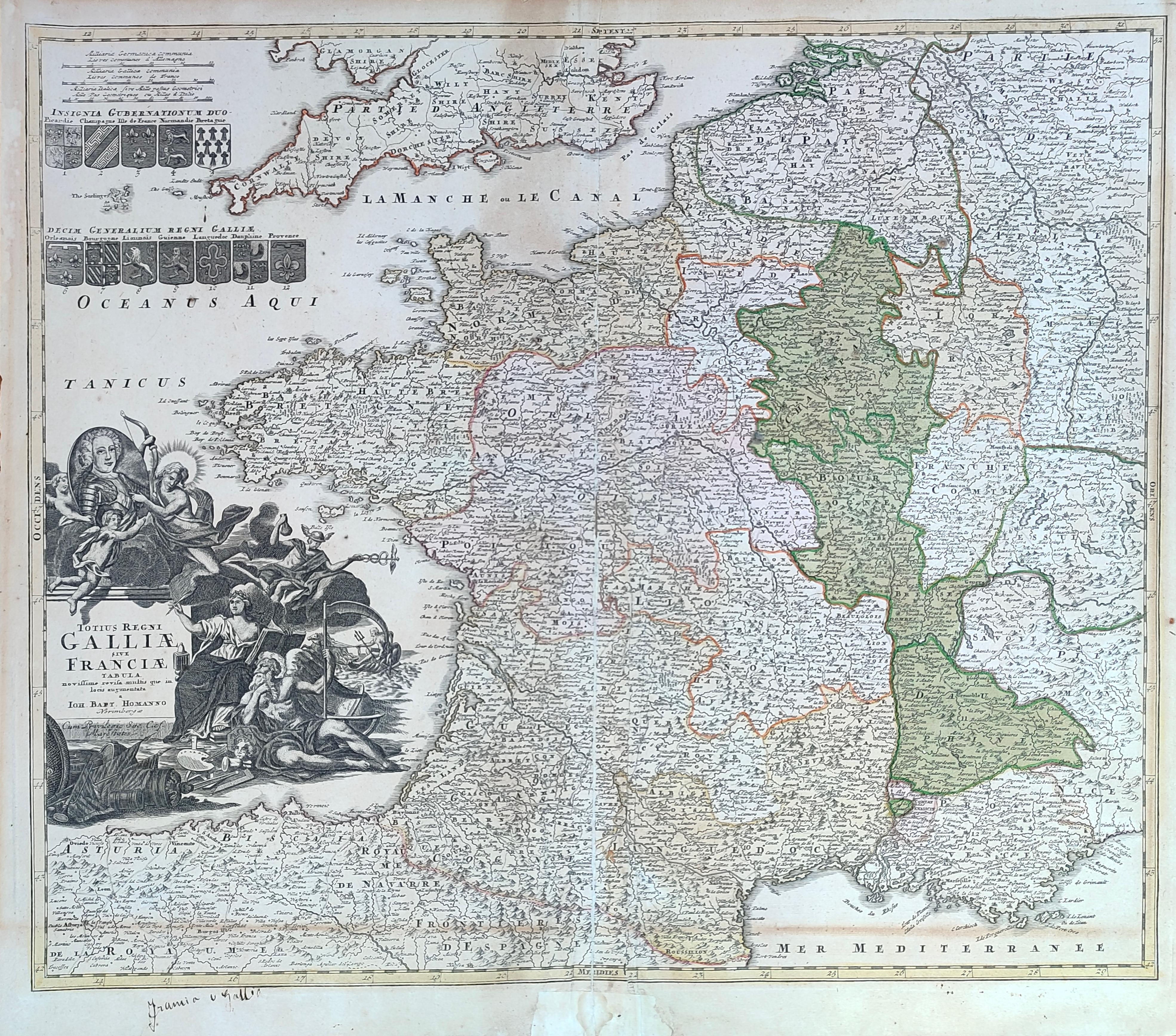
Map title
Totius regni Galliae sive Franciae tabula
Author
Homann
Location shown in map
France
Edition date
Circa 1720
Edition place
Nurimberg
Editor
--
Atlas
Price
200 Euro
State
[mint/excellent/VERY GOOD/good/fair/mediocre/poor]
Color
Old colors
Verso
Blank
Size
Plate: cm (58 x 48) inches (22.83 x 18.9) Paper: cm (59 x 52) inches (23.23 x 20.47)
Technique
Copper engraving
Note
Reference
Wiki
Here for more info
In stock
Available
Info
info@thetreasuremaps.com
Code
#1281
×
![Totius regni Galliae sive Franciae tabula by Homann, France, Circa 1720]()
Map title
Ducatus Mediolani
Author
Homann
Location shown in map
Liguria
Edition date
Circa 1720
Edition place
Nuremberg
Editor
--
Atlas
--
Price
350 Euro
State
[mint/excellent/VERY GOOD/good/fair/mediocre/poor]
Color
Old colors
Verso
Blank
Size
Plate: cm (0 x 0) inches (0 x 0) Paper: cm (0 x 0) inches (0 x 0)
Technique
Copper engraving
Note
Framed
Reference
--
Wiki
Here for more info
In stock
Available
Info
info@thetreasuremaps.com
Code
#1099
×
![Ducatus Mediolani by Homann, Liguria, Circa 1720]()
Map title
America Meridionale
Author
Sanson
Location shown in map
South America
Edition date
Circa 1720
Edition place
Editor
Atlas
Price
100 Euro
State
[mint/excellent/VERY GOOD/good/fair/mediocre/poor]
Color
Black/white
Verso
Blank
Size
Plate: cm (16.5 x 15) inches (6.5 x 5.91) Paper: cm (25 x 19) inches (9.84 x 7.48)
Technique
Copper engraving
Note
Reference
--
Wiki
Here for more info
In stock
Available
Info
info@thetreasuremaps.com
Code
#1142
×
![America Meridionale by Sanson, South America, Circa 1720]()
Map title
Africa
Author
Sanson
Location shown in map
Africa
Edition date
Circa 1720
Edition place
Editor
Atlas
Price
125 Euro
State
[mint/EXCELLENT/very good/good/fair/mediocre/poor]
Color
Black/white
Verso
Blank
Size
Plate: cm (16.5 x 15) inches (6.5 x 5.91) Paper: cm (21 x 19) inches (8.27 x 7.48)
Technique
Copper engraving
Note
Reference
--
Wiki
Here for more info
In stock
Available
Info
info@thetreasuremaps.com
Code
#1141
Africa
Author
Sanson
Location shown in map
Africa
Edition date
Circa 1720
Edition place
Editor
Atlas
Price
125 Euro
State
[mint/EXCELLENT/very good/good/fair/mediocre/poor]
Color
Black/white
Verso
Blank
Size
Plate: cm (16.5 x 15) inches (6.5 x 5.91) Paper: cm (21 x 19) inches (8.27 x 7.48)
Technique
Copper engraving
Note
Reference
--
Wiki
Here for more info
In stock
Available
Info
info@thetreasuremaps.com
Code
#1141
×
![Africa by Sanson, Africa, Circa 1720]()
Map title
America Settentrional
Author
Sanson
Location shown in map
North America
Edition date
Circa 1720
Edition place
Editor
Atlas
Price
250 Euro
State
[mint/EXCELLENT/very good/good/fair/mediocre/poor]
Color
Black/white
Verso
Blank
Size
Plate: cm (16.5 x 15) inches (6.5 x 5.91) Paper: cm (24 x 19) inches (9.45 x 7.48)
Technique
Copper engraving
Note
California as an island
Reference
--
Wiki
Here for more info
In stock
Available
Info
info@thetreasuremaps.com
Code
#1140
×
![America Settentrional by Sanson, North America, Circa 1720]()
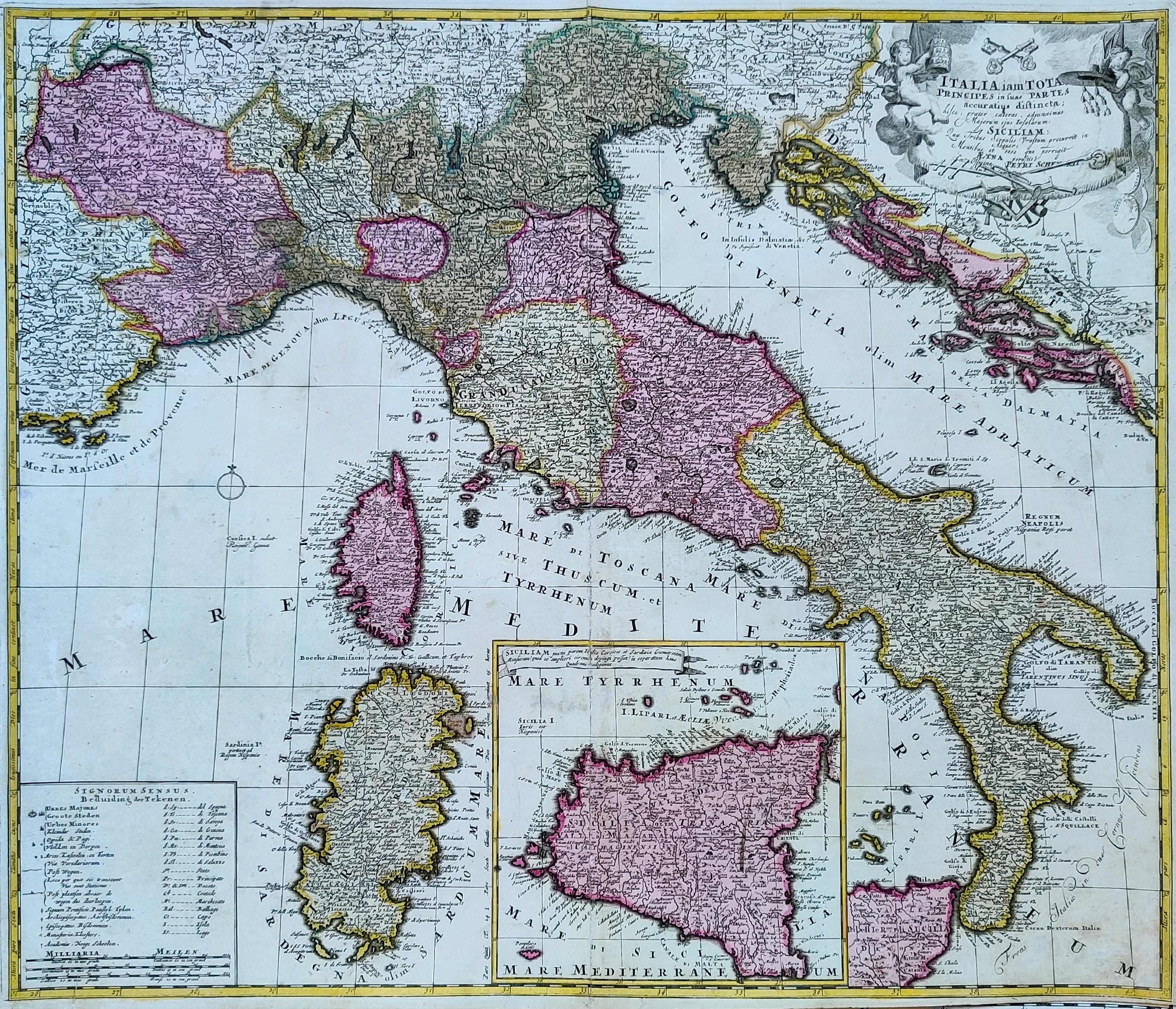
Map title
Italia iam Tota Principes in suas Partes, Accuratius Distincta...
Author
Schenk
Location shown in map
Italy
Edition date
1720
Edition place
Amsterdam
Editor
Schenk
Atlas
Atlas Contractus Sive Mapparum Geographicarum Sansoniarum Auctarum et Correctarum Nova Congeries
Price
600 Euro
State
[mint/EXCELLENT/very good/good/fair/mediocre/poor]
Color
Old colors
Verso
Blank
Size
Plate: cm (55 x 48) inches (21.65 x 18.9) Paper: cm (60 x 52) inches (23.62 x 20.47)
Technique
Copper engraving
Note
Reference
R.Borri L'Italia nelle antiche carte pag.179
Wiki
Here for more info
In stock
Available
Info
info@thetreasuremaps.com
Code
#0851
×
![Italia iam Tota Principes in suas Partes, Accuratius Distincta... by Schenk , Italy, 1720]()
Map title
Ducatus Sabaudiae Principatus Pedemontium et Ducatus Montisferratis
Author
Homann
Location shown in map
Piedmont
Edition date
1720
Edition place
Nuremberg
Editor
--
Atlas
--
Price
350 Euro
State
[mint/excellent/VERY GOOD/good/fair/mediocre/poor]
Color
Old colors
Verso
Blank
Size
Plate: cm (55.9 x 48.3) inches (22.01 x 19.02) Paper: cm (61 x 50.8) inches (24.02 x 20)
Technique
Copper engraving
Note
--
Reference
--
Wiki
Here for more info
In stock
Available
Info
info@thetreasuremaps.com
Code
#0510
×
![Ducatus Sabaudiae Principatus Pedemontium et Ducatus Montisferratis by Homann, Piedmont, 1720]()

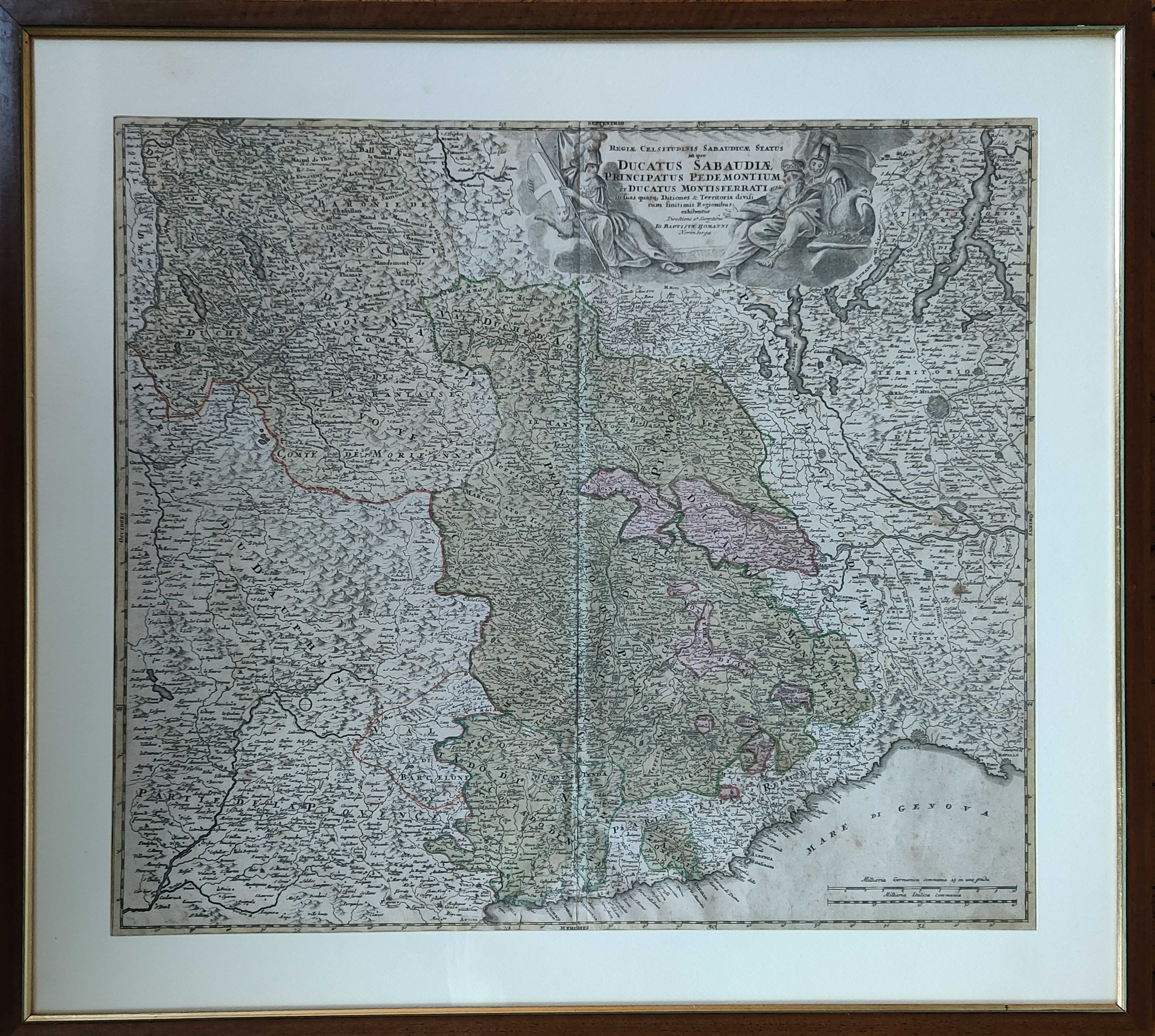
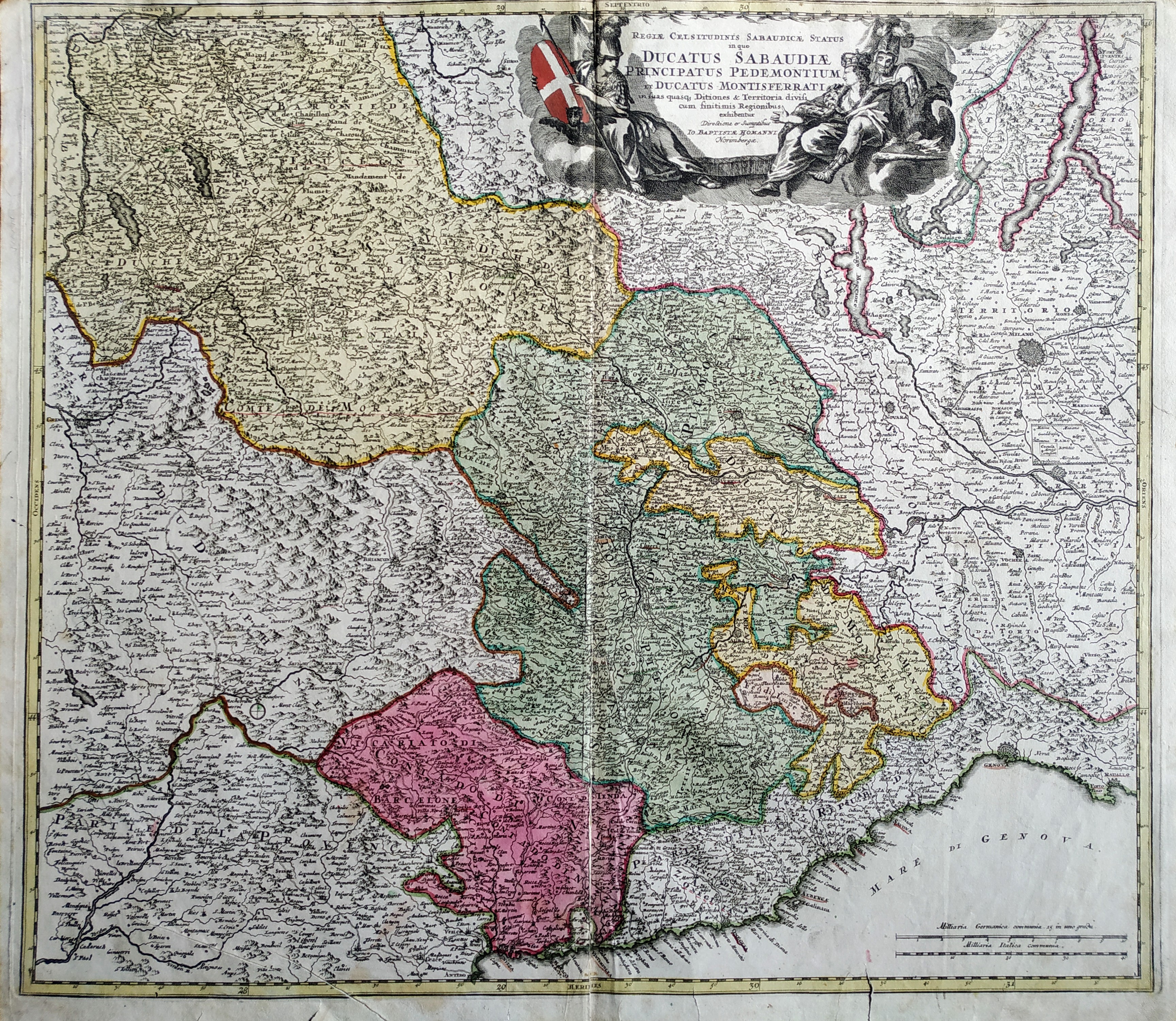
Map title
Regiae celsitudinis Sabaudiciae statu in quo Ducatus Sabaudiae Principatus Pedemontium et Ducatus Montisferrati
Author
Homann
Location shown in map
North-West Italy
Edition date
1720
Edition place
Nuremberg
Editor
--
Atlas
--
Price
Please ask: info@thetreasuremaps.com
State
[mint/excellent/very good/GOOD/fair/mediocre/poor]
Color
Old color
Verso
Blank
Size
Plate: cm (55.9 x 49.5) inches (22.01 x 19.49) Paper: cm (58.4 x 52.1) inches (22.99 x 20.51)
Technique
Copper engraving
Note
Some professional repaired tears. Missing left bottom corner 2mm
Reference
--
Wiki
Here for more info
In stock
Sold
Info
info@thetreasuremaps.com
Code
#0444
×
![Regiae celsitudinis Sabaudiciae statu in quo Ducatus Sabaudiae Principatus Pedemontium et Ducatus Montisferrati by Homann, North-West Italy, 1720]()