1700-1799
Map title
Les Iles Britanniques comprenant les Royaumes d'Angleterre ...
Author
Janvier
Location shown in map
England
Edition date
1784
Edition place
Venice
Editor
Atlas
Atlas Universel, dresse sur les meilleures cartes modernes
Price
250 Euro
State
[mint/EXCELLENT/very good/good/fair/mediocre/poor]
Color
Old colors
Verso
Blank
Size
Plate: cm (73 x 54) inches (28.74 x 21.26) Paper: cm (65 x 47) inches (25.59 x 18.5)
Technique
Copper engraving
Note
Reference
Wiki
Here for more info
In stock
Available
Info
info@thetreasuremaps.com
Code
#0920
×
![Les Iles Britanniques comprenant les Royaumes d'Angleterre ... by Janvier, England, 1784]()
Map title
Charte uber die XIII Vereinigte Staaten von Nord-America
Author
Homann
Location shown in map
USA
Edition date
1784
Edition place
Nuremberg
Editor
Atlas
Price
1300 Euro
State
[mint/EXCELLENT/very good/good/fair/mediocre/poor]
Color
Old colors
Verso
Blank
Size
Plate: cm (58 x 45) inches (22.83 x 17.72) Paper: cm (60 x 49) inches (23.62 x 19.29)
Technique
Copper engraving
Note
United States of America shortly after the revolution
Reference
Wiki
Here for more info
In stock
Available
Info
info@thetreasuremaps.com
Code
#1288
×
![Charte uber die XIII Vereinigte Staaten von Nord-America by Homann, USA, 1784]()
Map title
A Topographical Map of the Republick of Genova
Author
Gravier
Location shown in map
Liguria
Edition date
1784
Edition place
Genoa
Editor
Gravier
Atlas
Price
2500 Euro
State
[mint/EXCELLENT/very good/good/fair/mediocre/poor]
Color
Black/white
Verso
Blank
Size
Plate: cm (1855 x 1060) inches (730.31 x 417.32) Paper: cm (1855 x 1060) inches (730.31 x 417.32)
Technique
Copper engraving
Note
Reference
L.Tricerri, Catalog of Maps of Liguria R_093
Wiki
Here for more info
In stock
Available
Info
info@thetreasuremaps.com
Code
#1361
×
![A Topographical Map of the Republick of Genova by Gravier, Liguria, 1784]()
Map title
Emisfero Australe
Author
La Harpe
Location shown in map
South pole
Edition date
1785
Edition place
Italy
Editor
Prevost
Atlas
Compendio della Storia Generale de Viaggi
Price
300 Euro
State
[mint/EXCELLENT/very good/good/fair/mediocre/poor]
Color
Black/white
Verso
White
Size
Plate: cm (31.8 x 31.8) inches (12.52 x 12.52) Paper: cm (36.8 x 34.3) inches (14.49 x 13.5)
Technique
Copper engraving
Note
No particular notes for this maps.
Reference
--
Wiki
Here for more info
In stock
Available
Info
info@thetreasuremaps.com
Code
#0538
×
![Emisfero Australe by La Harpe, South pole, 1785]()
Map title
Tabula Italiae medii evi
Author
Giovanni Giacomo Spinelli
Location shown in map
Italy
Edition date
1785
Edition place
Milan
Editor
Atlas
Geschichte von Italien und allen allda gegrundeten altern und neuern Staaten
Price
350 Euro
State
[mint/EXCELLENT/very good/good/fair/mediocre/poor]
Color
Black/white
Verso
Blank
Size
Plate: cm (46 x 42) inches (18.11 x 16.54) Paper: cm (44 x 32) inches (17.32 x 12.6)
Technique
Copper engraving
Note
Reference
R.Borri L'Italia nelle antiche carte pag.216
Wiki
Here for more info
In stock
Available
Info
info@thetreasuremaps.com
Code
#0914
×
![Tabula Italiae medii evi by Giovanni Giacomo Spinelli, Italy, 1785]()
Map title
Stato della Repubblica di Genova
Author
Zatta
Location shown in map
Liguria
Edition date
1785
Edition place
Venice
Editor
Atlas
Atlante novissimo, illustrato ed accresciuto sulle osservazioni e scoperte fatte dai più celebri e più recenti geografi
Price
350 Euro
State
[mint/EXCELLENT/very good/good/fair/mediocre/poor]
Color
Old colors
Verso
Blank
Size
Plate: cm (31 x 42) inches (12.2 x 16.54) Paper: cm (48 x 39) inches (18.9 x 15.35)
Technique
Copper engraving
Note
Reference
L.Tricerri, Catalog of Maps of Liguria R_095
Wiki
Here for more info
In stock
Available
Info
info@thetreasuremaps.com
Code
#1335
×
![Stato della Repubblica di Genova by Zatta, Liguria, 1785]()
Map title
L'Europe
Author
Louise Brion De La Tour
Location shown in map
Europe
Edition date
1786
Edition place
Paris
Editor
--
Atlas
La geographie
Price
75 Euro
State
[mint/EXCELLENT/very good/good/fair/mediocre/poor]
Color
Black/white
Verso
Blank
Size
Plate: cm (25.4 x 22.9) inches (10 x 9.02) Paper: cm (27.9 x 25.4) inches (10.98 x 10)
Technique
Copper engraving
Note
No particular notes for this maps
Reference
--
Wiki
Here for more info
In stock
Available
Info
info@thetreasuremaps.com
Code
#0146
×
![L'Europe by Louise Brion De La Tour, Europe, 1786]()
Map title
Plan de la Ville de Genes
Author
Joseph Jerome Lefrancois de Lalande
Location shown in map
Genoa
Edition date
1786
Edition place
Paris
Editor
Atlas
Vojage en Italie
Price
150 Euro
State
[MINT/excellent/very good/good/fair/mediocre/poor]
Color
Old colors
Verso
Blank
Size
Plate: cm (36 x 24) inches (14.17 x 9.45) Paper: cm (38 x 27) inches (14.96 x 10.63)
Technique
Copper engraving
Note
Reference
Wiki
Here for more info
In stock
Available
Info
info@thetreasuremaps.com
Code
#0979
×
![Plan de la Ville de Genes by Joseph Jerome Lefrancois de Lalande , Genoa, 1786]()
Map title
Mappe Monde ou Carte Generale du Globe Terrestre
Author
Robert de Vaugondy
Location shown in map
World
Edition date
1786
Edition place
Paris
Editor
Delamarche
Atlas
Price
3000 Euro
State
[mint/EXCELLENT/very good/good/fair/mediocre/poor]
Color
Old colors
Verso
Blank
Size
Plate: cm (0 x 0) inches (0 x 0) Paper: cm (119 x 101) inches (46.85 x 39.76)
Technique
Copper engraving
Note
Framed, foldable map
Reference
Wiki
Here for more info
In stock
Available
Info
info@thetreasuremaps.com
Code
#1089
×
![Mappe Monde ou Carte Generale du Globe Terrestre by Robert de Vaugondy, World, 1786]()
Map title
Plan de la ville de Genes
Author
Joseph Jerome Lefrancois de Lalande
Location shown in map
Genoa
Edition date
1786
Edition place
Paris
Editor
--
Atlas
Voyage en Italie
Price
150 Euro
State
[mint/EXCELLENT/very good/good/fair/mediocre/poor]
Color
Old colors
Verso
Blank
Size
Plate: cm (37 x 25) inches (14.57 x 9.84) Paper: cm (43 x 28) inches (16.93 x 11.02)
Technique
Copper engraving
Note
--
Reference
--
Wiki
Here for more info
In stock
Available
Info
info@thetreasuremaps.com
Code
#1151
×
![Plan de la ville de Genes by Joseph Jerome Lefrancois de Lalande , Genoa, 1786]()
Map title
L'Allemagne, la Boheme et la Hongrie avec une partie de la Pologne
Author
Bonne
Location shown in map
Germany
Edition date
1787
Edition place
Paris
Editor
--
Atlas
Atlas Encyclopedique
Price
Please ask: info@thetreasuremaps.com
State
[mint/excellent/very good/good/FAIR/mediocre/poor]
Color
Modern outlined
Verso
Blank
Size
Plate: cm (31.8 x 21) inches (12.52 x 8.27) Paper: cm (36.8 x 25.4) inches (14.49 x 10)
Technique
Copper engraving
Note
No particular notes for this maps
Reference
--
Wiki
Here for more info
In stock
Available
Info
info@thetreasuremaps.com
Code
#0167
×
![L'Allemagne, la Boheme et la Hongrie avec une partie de la Pologne by Bonne, Germany, 1787]()

Map title
Carte de France
Author
Bonne
Location shown in map
France
Edition date
1787
Edition place
Paris
Editor
--
Atlas
Atlas Encyclopedique
Price
Please ask: info@thetreasuremaps.com
State
[mint/excellent/very good/good/FAIR/mediocre/poor]
Color
Modern outlined
Verso
Blank
Size
Plate: cm (27.9 x 22.9) inches (10.98 x 9.02) Paper: cm (30.5 x 25.4) inches (12.01 x 10)
Technique
Copper engraving
Note
No particular notes for this maps
Reference
--
Wiki
Here for more info
In stock
Sold
Info
info@thetreasuremaps.com
Code
#0168
×
![Carte de France by Bonne, France, 1787]()
Map title
Carte De La Louisiane Et De La Floride
Author
Bonne
Location shown in map
--
Edition date
1787
Edition place
Paris
Editor
--
Atlas
Atlas Encyclopedique
Price
Please ask: info@thetreasuremaps.com
State
[mint/excellent/very good/GOOD/fair/mediocre/poor]
Color
Modern outlined
Verso
Blank
Size
Plate: cm (31.8 x 21) inches (12.52 x 8.27) Paper: cm (34.3 x 22.9) inches (13.5 x 9.02)
Technique
Copper engraving
Note
In the southeast is Florida and the eastern Atlantic coast reaching as far north as Charleston, South Carolina. In the northeast is part of Virginia. In the northwest corner is the Missouri river with several tributaries, including the Osage. The western part of the map is dominated by the Mississsippi river and it tributaries. The inset in the lower left shows the area of Jefferson City, Missouri where the Osage and Grand rivers flow into the Missouri.
Reference
--
Wiki
Here for more info
In stock
Sold
Info
info@thetreasuremaps.com
Code
#0394
×
![Carte De La Louisiane Et De La Floride by Bonne, --, 1787]()
Map title
Les Isle Antilles Et Le Golfe Du Mexique
Author
Bonne
Location shown in map
--
Edition date
1787
Edition place
Paris
Editor
--
Atlas
Atlas Encyclopedique
Price
Please ask: info@thetreasuremaps.com
State
[mint/excellent/very good/GOOD/fair/mediocre/poor]
Color
Modern outlined
Verso
Blank
Size
Plate: cm (31.8 x 21) inches (12.52 x 8.27) Paper: cm (36.8 x 25.4) inches (14.49 x 10)
Technique
Copper engraving
Note
No particular notes for this maps
Reference
--
Wiki
Here for more info
In stock
Sold
Info
info@thetreasuremaps.com
Code
#0395
×
![Les Isle Antilles Et Le Golfe Du Mexique by Bonne, --, 1787]()
Map title
Carte de l'Empire de Russie en Europe et en Asie
Author
Bonne
Location shown in map
Russie
Edition date
1787
Edition place
Paris
Editor
--
Atlas
Atlas Encyclopedique
Price
Please ask: info@thetreasuremaps.com
State
[mint/excellent/very good/good/FAIR/mediocre/poor]
Color
Modern outlined
Verso
Blank
Size
Plate: cm (31.8 x 21) inches (12.52 x 8.27) Paper: cm (36.8 x 25.4) inches (14.49 x 10)
Technique
Copper engraving
Note
No particular notes for this maps
Reference
--
Wiki
Here for more info
In stock
Sold
Info
info@thetreasuremaps.com
Code
#0397
×
![Carte de l'Empire de Russie en Europe et en Asie by Bonne, Russie, 1787]()
Map title
L'Asie
Author
Bonne
Location shown in map
--
Edition date
1787
Edition place
Paris
Editor
--
Atlas
Atlas Encyclopedique
Price
Please ask: info@thetreasuremaps.com
State
[mint/EXCELLENT/very good/good/fair/mediocre/poor]
Color
Black/white
Verso
Blank
Size
Plate: cm (31.8 x 21) inches (12.52 x 8.27) Paper: cm (40.6 x 26.7) inches (15.98 x 10.51)
Technique
Copper engraving
Note
Fine map of the continent including Japan, Philippines, Indonesia and northern tip of Australia.
Reference
--
Wiki
Here for more info
In stock
Sold
Info
info@thetreasuremaps.com
Code
#0398
×
![L'Asie by Bonne, --, 1787]()
Map title
Amerique Meridionale
Author
Bonne
Location shown in map
South America
Edition date
1787
Edition place
Paris
Editor
--
Atlas
Atlas Encyclopedique
Price
Please ask: info@thetreasuremaps.com
State
[mint/excellent/very good/GOOD/fair/mediocre/poor]
Color
Modern outlined
Verso
Blank
Size
Plate: cm (31.8 x 21) inches (12.52 x 8.27) Paper: cm (31.8 x 21) inches (12.52 x 8.27)
Technique
Copper engraving
Note
No particular notes for this maps
Reference
--
Wiki
Here for more info
In stock
Sold
Info
info@thetreasuremaps.com
Code
#0399
×
![Amerique Meridionale by Bonne, South America, 1787]()
Map title
L'Allemagne, la Boheme et la Hongrie avec une partie de la Pologne
Author
Bonne
Location shown in map
--
Edition date
1787
Edition place
Paris
Editor
--
Atlas
Atlas Encyclopedique
Price
Please ask: info@thetreasuremaps.com
State
[mint/excellent/VERY GOOD/good/fair/mediocre/poor]
Color
Black/white
Verso
Blank
Size
Plate: cm (31.8 x 21) inches (12.52 x 8.27) Paper: cm (36.8 x 25.4) inches (14.49 x 10)
Technique
Copper engraving
Note
No particular notes for this maps
Reference
--
Wiki
Here for more info
In stock
Sold
Info
info@thetreasuremaps.com
Code
#0426
×
![L'Allemagne, la Boheme et la Hongrie avec une partie de la Pologne by Bonne, --, 1787]()
Map title
Governament de la Bretagne
Author
Bonne
Location shown in map
--
Edition date
1787
Edition place
Paris
Editor
--
Atlas
Atlas Encyclopedique
Price
Please ask: info@thetreasuremaps.com
State
[mint/excellent/VERY GOOD/good/fair/mediocre/poor]
Color
Black/white
Verso
Blank
Size
Plate: cm (31.8 x 21) inches (12.52 x 8.27) Paper: cm (36.8 x 25.4) inches (14.49 x 10)
Technique
Copper engraving
Note
No particular notes for this maps
Reference
--
Wiki
Here for more info
In stock
Sold
Info
info@thetreasuremaps.com
Code
#0427
×
![Governament de la Bretagne by Bonne, --, 1787]()
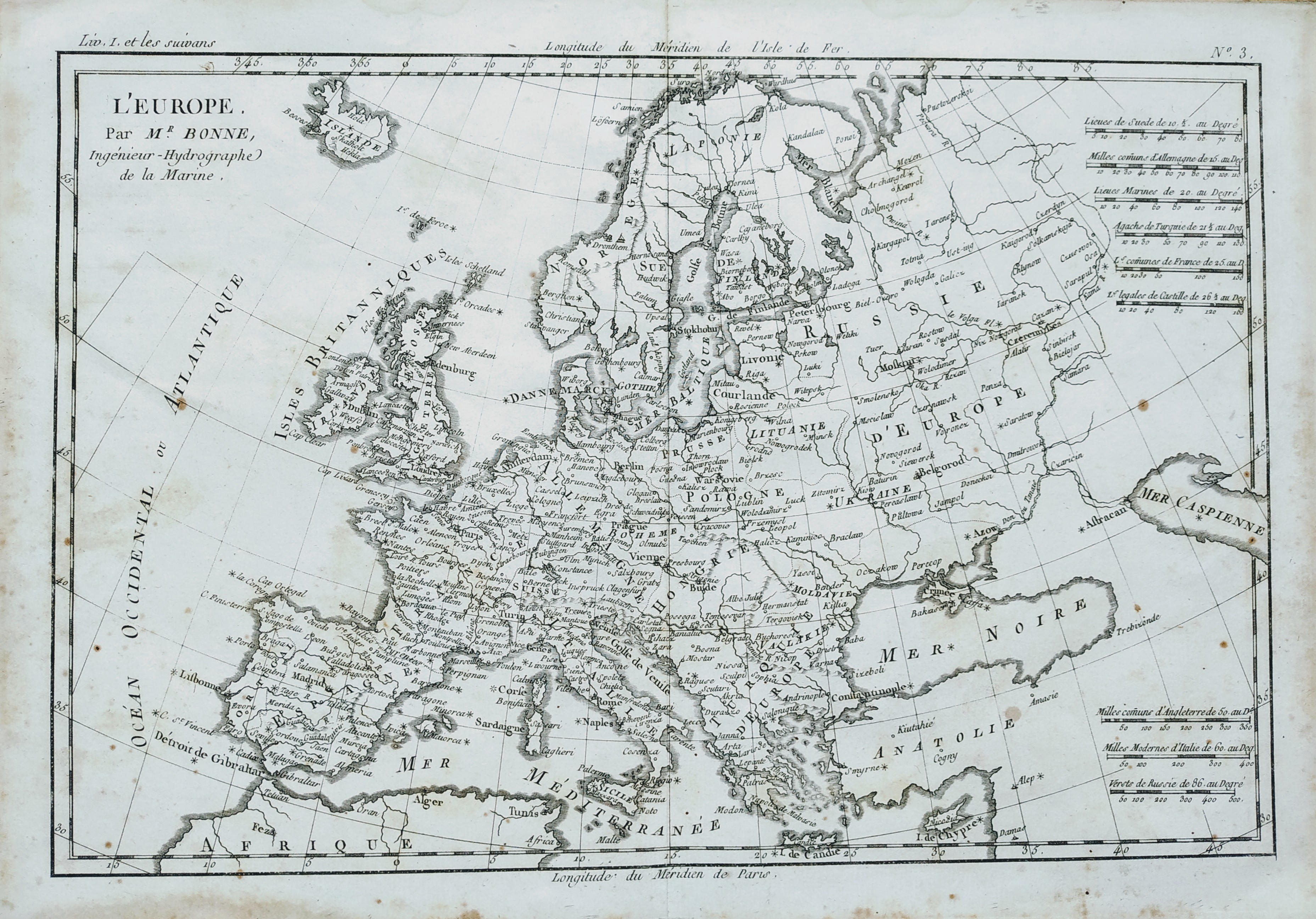
Map title
L'Europe
Author
Bonne
Location shown in map
Europe
Edition date
1787
Edition place
Paris
Editor
--
Atlas
Atlas Encyclopedique
Price
Please ask: info@thetreasuremaps.com
State
[mint/EXCELLENT/very good/good/fair/mediocre/poor]
Color
Black/white
Verso
Blank
Size
Plate: cm (31.8 x 21) inches (12.52 x 8.27) Paper: cm (35.6 x 25.4) inches (14.02 x 10)
Technique
Copper engraving
Note
--
Reference
--
Wiki
Here for more info
In stock
Available
Info
info@thetreasuremaps.com
Code
#0443
×
![L'Europe by Bonne, Europe, 1787]()