1700-1799

Map title
Carte du Chili depuis le sud du Perou jusqu'au cap Horn
Author
Bonne
Location shown in map
--
Edition date
1787
Edition place
Paris
Editor
--
Atlas
Atlas Encyclopedique
Price
Please ask: info@thetreasuremaps.com
State
[mint/excellent/very good/GOOD/fair/mediocre/poor]
Color
Modern outlined
Verso
Blank
Size
Plate: cm (31.8 x 21) inches (12.52 x 8.27) Paper: cm (31.8 x 21) inches (12.52 x 8.27)
Technique
Copper engraving
Note
No particular notes for this maps
Reference
--
Wiki
Here for more info
In stock
Sold
Info
info@thetreasuremaps.com
Code
#0461
×
![Carte du Chili depuis le sud du Perou jusqu'au cap Horn by Bonne, --, 1787]()
Map title
Carte De La Partie Sud, Des Etats Unis de L' Amerique Septentrionale
Author
Bonne
Location shown in map
East United States
Edition date
1787
Edition place
Paris
Editor
--
Atlas
Atlas Encyclopedique
Price
175 Euro
State
[mint/EXCELLENT/very good/good/fair/mediocre/poor]
Color
Old colors
Verso
Blank
Size
Plate: cm (31 x 21) inches (12.2 x 8.27) Paper: cm (36 x 25) inches (14.17 x 9.84)
Technique
Copper engraving
Note
No particular notes for this maps
Reference
--
Wiki
Here for more info
In stock
Available
Info
info@thetreasuremaps.com
Code
#0724
×
![Carte De La Partie Sud, Des Etats Unis de L' Amerique Septentrionale by Bonne, East United States, 1787]()
Map title
Karte von England und Wallis
Author
Thomas Kitchin
Location shown in map
England
Edition date
1787
Edition place
Wien
Editor
Atlas
Price
350 Euro
State
[mint/EXCELLENT/very good/good/fair/mediocre/poor]
Color
Black/white
Verso
Blank
Size
Plate: cm (0 x 0) inches (0 x 0) Paper: cm (0 x 0) inches (0 x 0)
Technique
Copper engraving
Note
Reference
Wiki
Here for more info
In stock
Available
Info
info@thetreasuremaps.com
Code
#0826
×
![Karte von England und Wallis by Thomas Kitchin, England, 1787]()
Map title
Mappemonde
Author
Bonne
Location shown in map
Polar antarctic regions
Edition date
1787
Edition place
Paris
Editor
Atlas
Atlas Encyclopedique
Price
150 Euro
State
[mint/EXCELLENT/very good/good/fair/mediocre/poor]
Color
Old colors
Verso
Blank
Size
Plate: cm (34 x 23) inches (13.39 x 9.06) Paper: cm (47 x 32) inches (18.5 x 12.6)
Technique
Copper engraving
Note
Reference
Wiki
Here for more info
In stock
Available
Info
info@thetreasuremaps.com
Code
#0848
×
![Mappemonde by Bonne, Polar antarctic regions, 1787]()
Map title
L'Italie
Author
Bonne
Location shown in map
Italy
Edition date
1787
Edition place
Paris
Editor
Atlas
Atlas Encyclopedique
Price
125 Euro
State
[mint/EXCELLENT/very good/good/fair/mediocre/poor]
Color
Black/white
Verso
Blank
Size
Plate: cm (22 x 35) inches (8.66 x 13.78) Paper: cm (25 x 37) inches (9.84 x 14.57)
Technique
Copper engraving
Note
Reference
Wiki
Here for more info
In stock
Available
Info
info@thetreasuremaps.com
Code
#0931
×
![L'Italie by Bonne, Italy, 1787]()
Map title
Plan de Belgrade capitale de la Servie, avec ses nouvelles fortifications.
Author
Unknown
Location shown in map
--
Edition date
1788
Edition place
Paris
Editor
--
Atlas
--
Price
Please ask: info@thetreasuremaps.com
State
[mint/EXCELLENT/very good/good/fair/mediocre/poor]
Color
Old colors
Verso
Blank
Size
Plate: cm (44.4 x 55.9) inches (17.48 x 22.01) Paper: cm (53.3 x 71.1) inches (20.98 x 27.99)
Technique
--
Note
No particular notes for this maps
Reference
--
Wiki
Here for more info
In stock
Sold
Info
info@thetreasuremaps.com
Code
#0441
×
![Plan de Belgrade capitale de la Servie, avec ses nouvelles fortifications. by Unknown, --, 1788]()
Map title
Mapa de la Parte del Norte Del Mar Del Sur
Author
Pedro de Gongora
Location shown in map
North Pacific
Edition date
1788
Edition place
Madrid
Editor
D. Antonio de Sancha
Atlas
Price
200 Euro
State
[mint/EXCELLENT/very good/good/fair/mediocre/poor]
Color
Black/white
Verso
Blank
Size
Plate: cm (34 x 24) inches (13.39 x 9.45) Paper: cm (36 x 29) inches (14.17 x 11.42)
Technique
Copper engraving
Note
Reference
--
Wiki
Here for more info
In stock
Available
Info
info@thetreasuremaps.com
Code
#1001
×
![Mapa de la Parte del Norte Del Mar Del Sur by Pedro de Gongora, North Pacific, 1788]()
Map title
Carte generale des Postes d'Italie ...
Author
Location shown in map
Italy
Edition date
1788
Edition place
Paris
Editor
Atlas
Price
350 Euro
State
[mint/EXCELLENT/very good/good/fair/mediocre/poor]
Color
Black/white
Verso
Blank
Size
Plate: cm (78 x 51) inches (30.71 x 20.08) Paper: cm (78 x 51) inches (30.71 x 20.08)
Technique
Copper engraving
Note
Reference
R.Borri L'Italia nelle antiche carte pag.227
Wiki
Here for more info
In stock
Available
Info
info@thetreasuremaps.com
Code
#1169
×
![Carte generale des Postes d'Italie ... by , Italy, 1788]()
Map title
Amerique Septentrionale
Author
Bonne
Location shown in map
North America
Edition date
1789
Edition place
Paris
Editor
Atlas
Atlas Encyclopedique
Price
175 Euro
State
[mint/EXCELLENT/very good/good/fair/mediocre/poor]
Color
Old colors
Verso
Blank
Size
Plate: cm (32 x 22) inches (12.6 x 8.66) Paper: cm (36 x 25) inches (14.17 x 9.84)
Technique
Copper engraving
Note
Reference
Wiki
Here for more info
In stock
Available
Info
info@thetreasuremaps.com
Code
#0815
×
![Amerique Septentrionale by Bonne, North America, 1789]()
Map title
Carte d'Europe
Author
De L'Isle
Location shown in map
Europe
Edition date
1789
Edition place
Paris
Editor
Dezauche
Atlas
Price
200 Euro
State
[mint/EXCELLENT/very good/good/fair/mediocre/poor]
Color
Old color
Verso
Blank
Size
Plate: cm (61 x 50) inches (24.02 x 19.69) Paper: cm (76 x 53) inches (29.92 x 20.87)
Technique
Copper engraving
Note
Reference
Wiki
Here for more info
In stock
Available
Info
info@thetreasuremaps.com
Code
#0784
×
![Carte d'Europe by De L'Isle, Europe, 1789]()
Map title
Carte generale des toutes les parties connues
Author
Bonne
Location shown in map
World
Edition date
1789
Edition place
Paris
Editor
Atlas
Atlas Encyclopedique
Price
150 Euro
State
[mint/EXCELLENT/very good/good/fair/mediocre/poor]
Color
Black/white
Verso
Blank
Size
Plate: cm (34 x 23) inches (13.39 x 9.06) Paper: cm (40 x 28) inches (15.75 x 11.02)
Technique
Copper engraving
Note
Reference
Wiki
Here for more info
In stock
Available
Info
info@thetreasuremaps.com
Code
#0779
×
![Carte generale des toutes les parties connues by Bonne, World, 1789]()
Map title
Asia, secondo le ultime osservazioni dell'accademia reale delle scienze
Author
Buffier
Location shown in map
Asia
Edition date
1790
Edition place
Rome
Editor
--
Atlas
Geographie universelle, italian edition.
Price
75 Euro
State
[mint/EXCELLENT/very good/good/fair/mediocre/poor]
Color
Black/white
Verso
Blank
Size
Plate: cm (17.8 x 13.3) inches (7.01 x 5.24) Paper: cm (19.7 x 16.5) inches (7.76 x 6.5)
Technique
Copper engraving
Note
Claude Buffier was a Jesuit theologian and geographer working in Paris, who wrote the Geographie Universelle, first issued in about 1715. The Geographie was issued as a pocket-sized volume, illustrated with a set of maps.The volume proved very popular, and numerous editions were published in Paris, Naples and Rome. The book was evidently targeted at the popular market, and for this reason examples of the book tend to be printed on relatively poor quality paper, and this is particularly true of the Italian editions.Evidently there were a large number of different sets of map plates used - so far 17 different plates or states of plates have been identified for the Americas map, some engraved anonymously, and other signed by Hendrick van Loon, Faure, Denise Macquart and Dom. Dell'Acerra Unfortunately, it has been frequent practice to disperse such volumes, so the origin of several of these plates has not yet been identified, and the editor would be grateful to hear from readers about editions of the book, particularly those containing maps engraved by Denise Macquart and Dom. Dell'Acerra.[http://www.mapforum.com]
Reference
--
Wiki
Here for more info
In stock
Available
Info
info@thetreasuremaps.com
Code
#0220
×
![Asia, secondo le ultime osservazioni dell'accademia reale delle scienze by Buffier, Asia, 1790]()
Map title
Africa, secondo le ultime osservazioni dell'accademia reale delle scienze
Author
Buffier
Location shown in map
Africa
Edition date
1790
Edition place
Rome
Editor
--
Atlas
Geographie universelle, italian edition.
Price
125 Euro
State
[mint/EXCELLENT/very good/good/fair/mediocre/poor]
Color
Black/white
Verso
Blank
Size
Plate: cm (17.8 x 14) inches (7.01 x 5.51) Paper: cm (24.1 x 20.3) inches (9.49 x 7.99)
Technique
Copper engraving
Note
Claude Buffier was a Jesuit theologian and geographer working in Paris, who wrote the Geographie Universelle, first issued in about 1715. The Geographie was issued as a pocket-sized volume, illustrated with a set of maps.The volume proved very popular, and numerous editions were published in Paris, Naples and Rome. The book was evidently targeted at the popular market, and for this reason examples of the book tend to be printed on relatively poor quality paper, and this is particularly true of the Italian editions.Evidently there were a large number of different sets of map plates used - so far 17 different plates or states of plates have been identified for the Americas map, some engraved anonymously, and other signed by Hendrick van Loon, Faure, Denise Macquart and Dom. Dell'Acerra Unfortunately, it has been frequent practice to disperse such volumes, so the origin of several of these plates has not yet been identified, and the editor would be grateful to hear from readers about editions of the book, particularly those containing maps engraved by Denise Macquart and Dom. Dell'Acerra.
Reference
--
Wiki
Here for more info
In stock
Available
Info
info@thetreasuremaps.com
Code
#0298
×
![Africa, secondo le ultime osservazioni dell'accademia reale delle scienze by Buffier, Africa, 1790]()
Map title
America, secondo le ultime osservazioni dell'accademia reale delle scienze
Author
Buffier
Location shown in map
America
Edition date
1790
Edition place
Rome
Editor
--
Atlas
Geographie universelle, italian edition.
Price
Please ask: info@thetreasuremaps.com
State
[mint/excellent/very good/GOOD/fair/mediocre/poor]
Color
Black/white
Verso
Blank
Size
Plate: cm (14 x 17.8) inches (5.51 x 7.01) Paper: cm (15.2 x 19) inches (5.98 x 7.48)
Technique
Copper engraving
Note
Claude Buffier was a Jesuit theologian and geographer working in Paris, who wrote the Geographie Universelle, first issued in about 1715. The Geographie was issued as a pocket-sized volume, illustrated with a set of maps.The volume proved very popular, and numerous editions were published in Paris, Naples and Rome. The book was evidently targeted at the popular market, and for this reason examples of the book tend to be printed on relatively poor quality paper, and this is particularly true of the Italian editions.Evidently there were a large number of different sets of map plates used - so far 17 different plates or states of plates have been identified for the Americas map, some engraved anonymously, and other signed by Hendrick van Loon, Faure, Denise Macquart and Dom. Dell'Acerra Unfortunately, it has been frequent practice to disperse such volumes, so the origin of several of these plates has not yet been identified, and the editor would be grateful to hear from readers about editions of the book, particularly those containing maps engraved by Denise Macquart and Dom. Dell'Acerra.
Reference
--
Wiki
Here for more info
In stock
Sold
Info
info@thetreasuremaps.com
Code
#0384
×
![America, secondo le ultime osservazioni dell'accademia reale delle scienze by Buffier, America, 1790]()
Map title
America Settentrionale
Author
Sanson
Location shown in map
North America
Edition date
Circa 1790
Edition place
Editor
--
Atlas
Geographie universelle, italian edition.
Price
125 Euro
State
[mint/EXCELLENT/very good/good/fair/mediocre/poor]
Color
Black/white
Verso
Blank
Size
Plate: cm (22 x 16) inches (8.66 x 6.3) Paper: cm (25 x 20) inches (9.84 x 7.87)
Technique
Copper engraving
Note
Claude Buffier was a Jesuit theologian and geographer working in Paris, who wrote the Geographie Universelle, first issued in about 1715. The Geographie was issued as a pocket-sized volume, illustrated with a set of maps.The volume proved very popular, and numerous editions were published in Paris, Naples and Rome. The book was evidently targeted at the popular market, and for this reason examples of the book tend to be printed on relatively poor quality paper, and this is particularly true of the Italian editions.Evidently there were a large number of different sets of map plates used - so far 17 different plates or states of plates have been identified for the Americas map, some engraved anonymously, and other signed by Hendrick van Loon, Faure, Denise Macquart and Dom. Dell'Acerra Unfortunately, it has been frequent practice to disperse such volumes, so the origin of several of these plates has not yet been identified, and the editor would be grateful to hear from readers about editions of the book, particularly those containing maps engraved by Denise Macquart and Dom. Dell'Acerra.
Reference
--
Wiki
Here for more info
In stock
Available
Info
info@thetreasuremaps.com
Code
#0941
×
![America Settentrionale by Sanson, North America, Circa 1790]()
Map title
America Meridionale
Author
Sanson
Location shown in map
South America
Edition date
Circa 1790
Edition place
Editor
--
Atlas
Geographie universelle, italian edition.
Price
125 Euro
State
[mint/EXCELLENT/very good/good/fair/mediocre/poor]
Color
Black/white
Verso
Blank
Size
Plate: cm (18 x 21) inches (7.09 x 8.27) Paper: cm (20 x 24) inches (7.87 x 9.45)
Technique
Copper engraving
Note
Claude Buffier was a Jesuit theologian and geographer working in Paris, who wrote the Geographie Universelle, first issued in about 1715. The Geographie was issued as a pocket-sized volume, illustrated with a set of maps.The volume proved very popular, and numerous editions were published in Paris, Naples and Rome. The book was evidently targeted at the popular market, and for this reason examples of the book tend to be printed on relatively poor quality paper, and this is particularly true of the Italian editions.Evidently there were a large number of different sets of map plates used - so far 17 different plates or states of plates have been identified for the Americas map, some engraved anonymously, and other signed by Hendrick van Loon, Faure, Denise Macquart and Dom. Dell'Acerra Unfortunately, it has been frequent practice to disperse such volumes, so the origin of several of these plates has not yet been identified, and the editor would be grateful to hear from readers about editions of the book, particularly those containing maps engraved by Denise Macquart and Dom. Dell'Acerra.
Reference
--
Wiki
Here for more info
In stock
Available
Info
info@thetreasuremaps.com
Code
#0942
×
![America Meridionale by Sanson, South America, Circa 1790]()
Map title
L'Italie divisee en ses different etats royaumes et republiques
Author
Location shown in map
Italy
Edition date
Circa 1790
Edition place
Paris
Editor
Atlas
L historie universelle d une societe de gens de Lettres
Price
175 Euro
State
[mint/EXCELLENT/very good/good/fair/mediocre/poor]
Color
Black/white
Verso
Blank
Size
Plate: cm (34 x 30) inches (13.39 x 11.81) Paper: cm (41 x 33) inches (16.14 x 12.99)
Technique
Copper engraving
Note
Reference
R.Borri L'Italia nelle antiche carte pag.267
Wiki
Here for more info
In stock
Available
Info
info@thetreasuremaps.com
Code
#1379
×
![L'Italie divisee en ses different etats royaumes et republiques by , Italy, Circa 1790]()
Map title
Stati uniti di America
Author
Unknown
Location shown in map
--
Edition date
1795
Edition place
Venice
Editor
--
Atlas
Compendio di geografia di Guthrie.
Price
125 Euro
State
[mint/EXCELLENT/very good/good/fair/mediocre/poor]
Color
Old outlined
Verso
Blank
Size
Plate: cm (20.3 x 17.8) inches (7.99 x 7.01) Paper: cm (20.3 x 17.8) inches (7.99 x 7.01)
Technique
Copper engraving
Note
This map shows the United States before the aquisition of Florida.
Reference
--
Wiki
Here for more info
In stock
Available
Info
info@thetreasuremaps.com
Code
#0083
×
![Stati uniti di America by Unknown, --, 1795]()
Map title
L'Amerique
Author
Robert de Vaugondy
Location shown in map
Americas
Edition date
1795
Edition place
Paris
Editor
Delamarche
Atlas
Atlas Portatif de Vaugondy
Price
100 Euro
State
[MINT/excellent/very good/good/fair/mediocre/poor]
Color
Old color
Verso
Blank
Size
Plate: cm (22 x 24) inches (8.66 x 9.45) Paper: cm (37 x 30) inches (14.57 x 11.81)
Technique
Copper engraving
Note
Reference
--
Wiki
Here for more info
In stock
Available
Info
info@thetreasuremaps.com
Code
#0752
×
![L'Amerique by Robert de Vaugondy, Americas, 1795]()
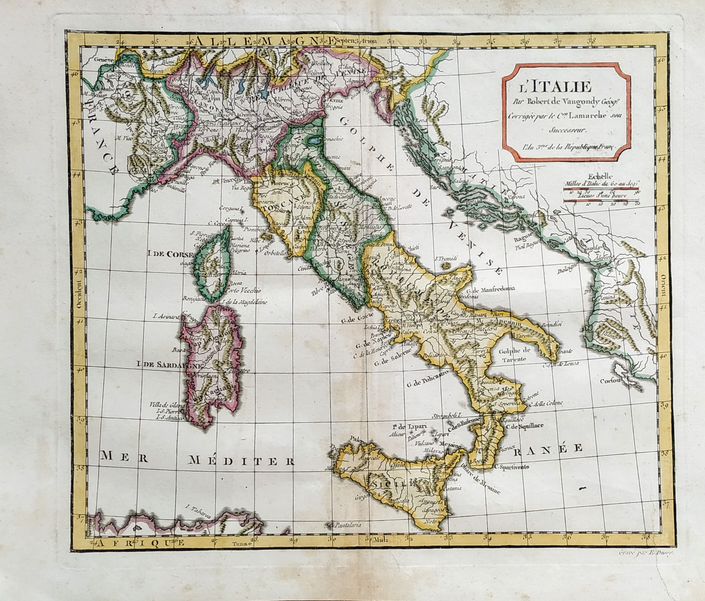
Map title
L'Italie
Author
Robert de Vaugondy
Location shown in map
Italy
Edition date
1795
Edition place
Paris
Editor
Atlas
Atlas portatif universel et militaire
Price
125 Euro
State
[mint/EXCELLENT/very good/good/fair/mediocre/poor]
Color
Old colors
Verso
Blank
Size
Plate: cm (37 x 26) inches (14.57 x 10.24) Paper: cm (44 x 32) inches (17.32 x 12.6)
Technique
Copper engraving
Note
Reference
--
Wiki
Here for more info
In stock
Available
Info
info@thetreasuremaps.com
Code
#0821
×
![L'Italie by Robert de Vaugondy, Italy, 1795]()