1700-1799
Map title
Ducatus Sabaudiae Principatus Pedemontium et Ducatus Montisferratis
Author
Homann
Location shown in map
Piedmont
Edition date
Circa 1720
Edition place
Nuremberg
Editor
--
Atlas
--
Price
350 Euro
State
[mint/excellent/VERY GOOD/good/fair/mediocre/poor]
Color
Old colors
Verso
Blank
Size
Plate: cm (55.9 x 48.3) inches (22.01 x 19.02) Paper: cm (61 x 50.8) inches (24.02 x 20)
Technique
Copper engraving
Note
Framed
Reference
--
Wiki
Here for more info
In stock
Available
Info
info@thetreasuremaps.com
Code
#1098
×
![Ducatus Sabaudiae Principatus Pedemontium et Ducatus Montisferratis by Homann, Piedmont, Circa 1720]()
Map title
Mappamondo o sia carta generale del Globo Terrestre
Author
Sanson
Location shown in map
World
Edition date
Circa 1720
Edition place
Editor
Atlas
Price
200 Euro
State
[mint/excellent/VERY GOOD/good/fair/mediocre/poor]
Color
Black/white
Verso
Blank
Size
Plate: cm (16.5 x 14) inches (6.5 x 5.51) Paper: cm (21 x 19) inches (8.27 x 7.48)
Technique
Copper engraving
Note
Reference
--
Wiki
Here for more info
In stock
Available
Info
info@thetreasuremaps.com
Code
#1139
×
![Mappamondo o sia carta generale del Globo Terrestre by Sanson, World, Circa 1720]()
Map title
America Settentrional
Author
Sanson
Location shown in map
North America
Edition date
Circa 1720
Edition place
Editor
Atlas
Price
250 Euro
State
[mint/EXCELLENT/very good/good/fair/mediocre/poor]
Color
Black/white
Verso
Blank
Size
Plate: cm (16.5 x 15) inches (6.5 x 5.91) Paper: cm (24 x 19) inches (9.45 x 7.48)
Technique
Copper engraving
Note
California as an island
Reference
--
Wiki
Here for more info
In stock
Available
Info
info@thetreasuremaps.com
Code
#1140
×
![America Settentrional by Sanson, North America, Circa 1720]()
Map title
Africa
Author
Sanson
Location shown in map
Africa
Edition date
Circa 1720
Edition place
Editor
Atlas
Price
125 Euro
State
[mint/EXCELLENT/very good/good/fair/mediocre/poor]
Color
Black/white
Verso
Blank
Size
Plate: cm (16.5 x 15) inches (6.5 x 5.91) Paper: cm (21 x 19) inches (8.27 x 7.48)
Technique
Copper engraving
Note
Reference
--
Wiki
Here for more info
In stock
Available
Info
info@thetreasuremaps.com
Code
#1141
Africa
Author
Sanson
Location shown in map
Africa
Edition date
Circa 1720
Edition place
Editor
Atlas
Price
125 Euro
State
[mint/EXCELLENT/very good/good/fair/mediocre/poor]
Color
Black/white
Verso
Blank
Size
Plate: cm (16.5 x 15) inches (6.5 x 5.91) Paper: cm (21 x 19) inches (8.27 x 7.48)
Technique
Copper engraving
Note
Reference
--
Wiki
Here for more info
In stock
Available
Info
info@thetreasuremaps.com
Code
#1141
×
![Africa by Sanson, Africa, Circa 1720]()
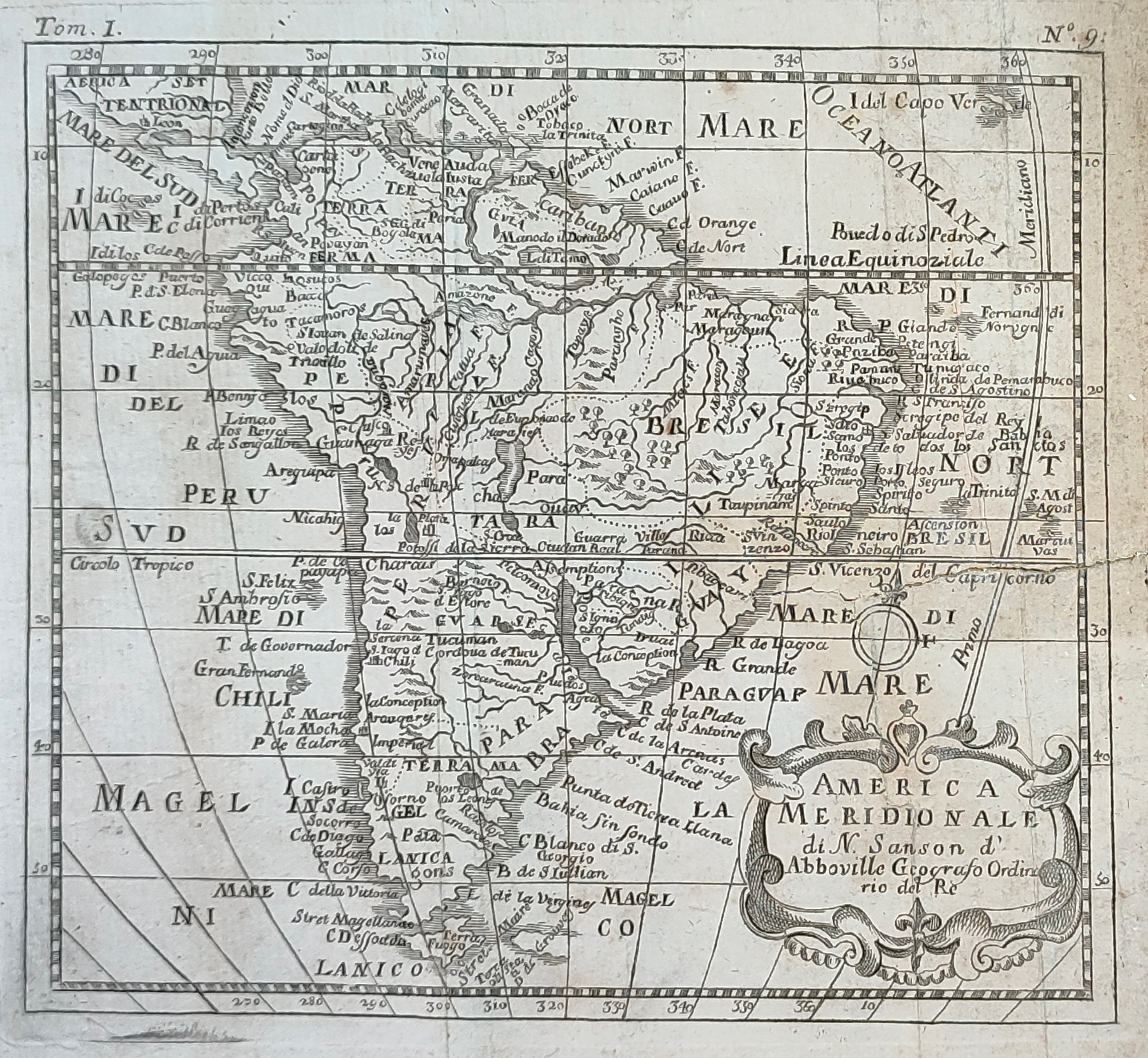
Map title
America Meridionale
Author
Sanson
Location shown in map
South America
Edition date
Circa 1720
Edition place
Editor
Atlas
Price
100 Euro
State
[mint/excellent/VERY GOOD/good/fair/mediocre/poor]
Color
Black/white
Verso
Blank
Size
Plate: cm (16.5 x 15) inches (6.5 x 5.91) Paper: cm (25 x 19) inches (9.84 x 7.48)
Technique
Copper engraving
Note
Reference
--
Wiki
Here for more info
In stock
Available
Info
info@thetreasuremaps.com
Code
#1142
×
![America Meridionale by Sanson, South America, Circa 1720]()
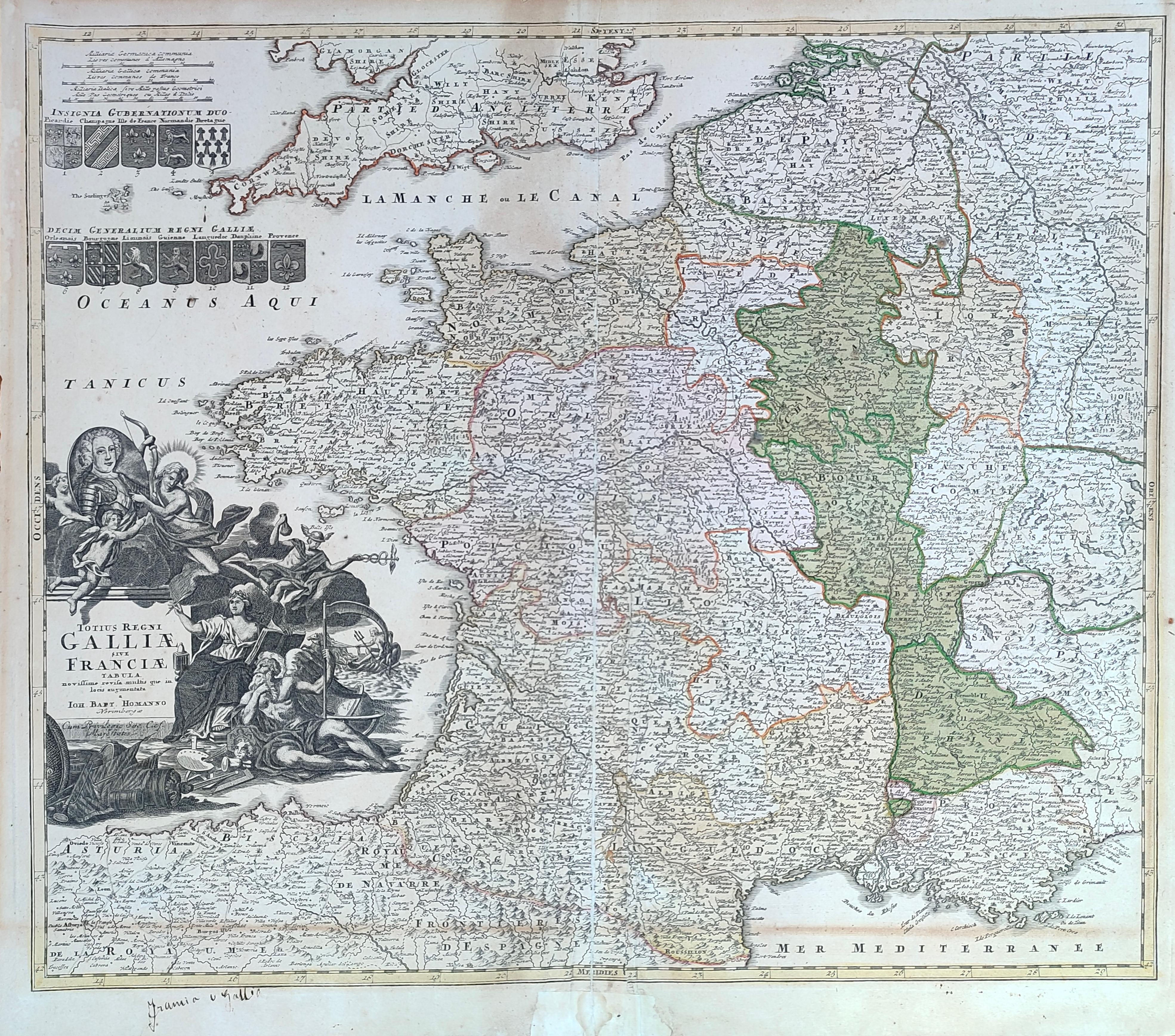
Map title
Totius regni Galliae sive Franciae tabula
Author
Homann
Location shown in map
France
Edition date
Circa 1720
Edition place
Nurimberg
Editor
--
Atlas
Price
200 Euro
State
[mint/excellent/VERY GOOD/good/fair/mediocre/poor]
Color
Old colors
Verso
Blank
Size
Plate: cm (58 x 48) inches (22.83 x 18.9) Paper: cm (59 x 52) inches (23.23 x 20.47)
Technique
Copper engraving
Note
Reference
Wiki
Here for more info
In stock
Available
Info
info@thetreasuremaps.com
Code
#1281
×
![Totius regni Galliae sive Franciae tabula by Homann, France, Circa 1720]()
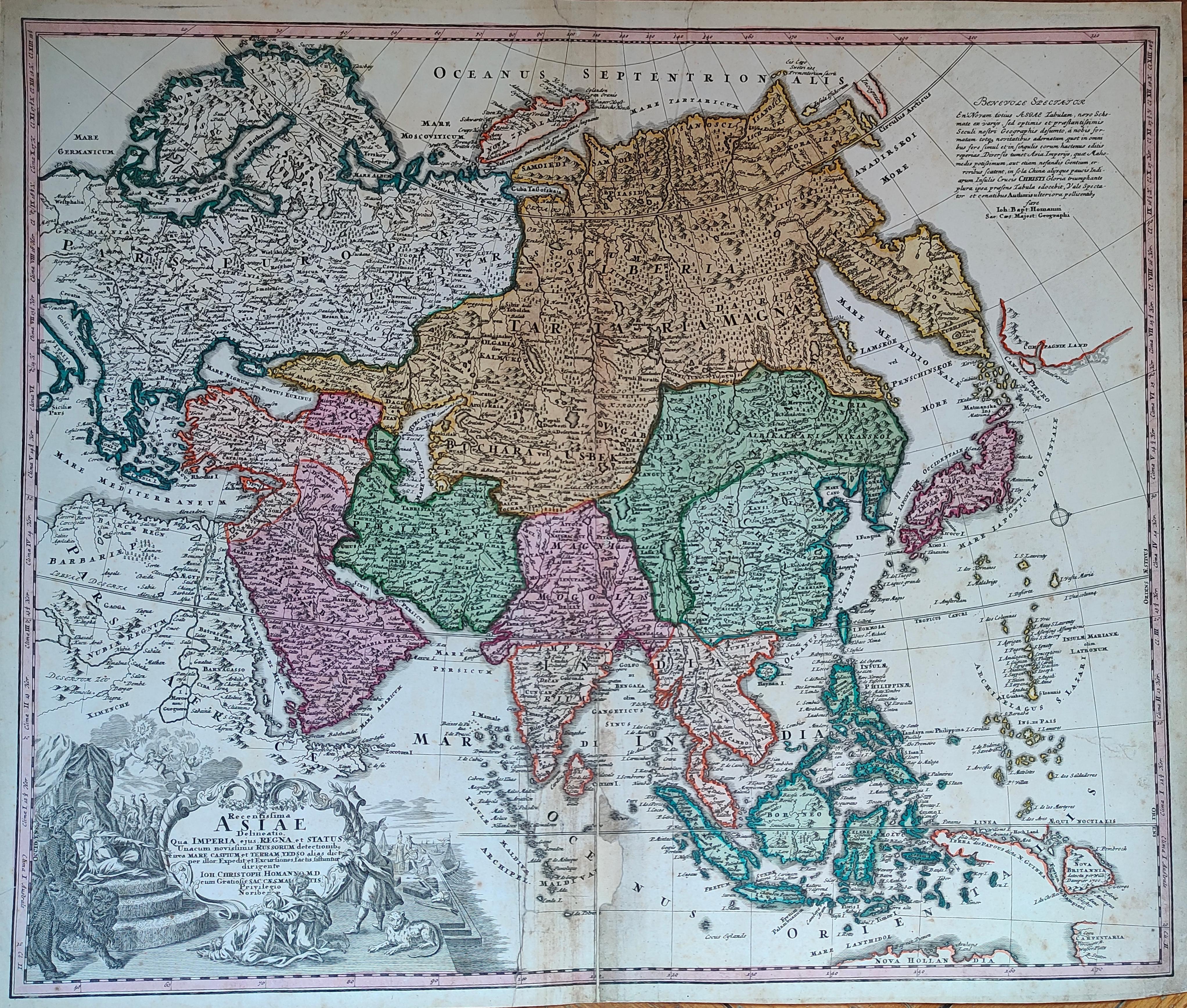
Map title
Asiae Recentissima Delineatio Qua Status et Imperia Totius Orientis unacum Orientalibus Indiis
Author
Homann
Location shown in map
Asia
Edition date
Circa 1720
Edition place
Nurimberg
Editor
--
Atlas
Price
400 Euro
State
[mint/excellent/VERY GOOD/good/fair/mediocre/poor]
Color
Old colors
Verso
Blank
Size
Plate: cm (58 x 48) inches (22.83 x 18.9) Paper: cm (59 x 52) inches (23.23 x 20.47)
Technique
Copper engraving
Note
Reference
Wiki
Here for more info
In stock
Available
Info
info@thetreasuremaps.com
Code
#1282
×
![Asiae Recentissima Delineatio Qua Status et Imperia Totius Orientis unacum Orientalibus Indiis by Homann, Asia, Circa 1720]()
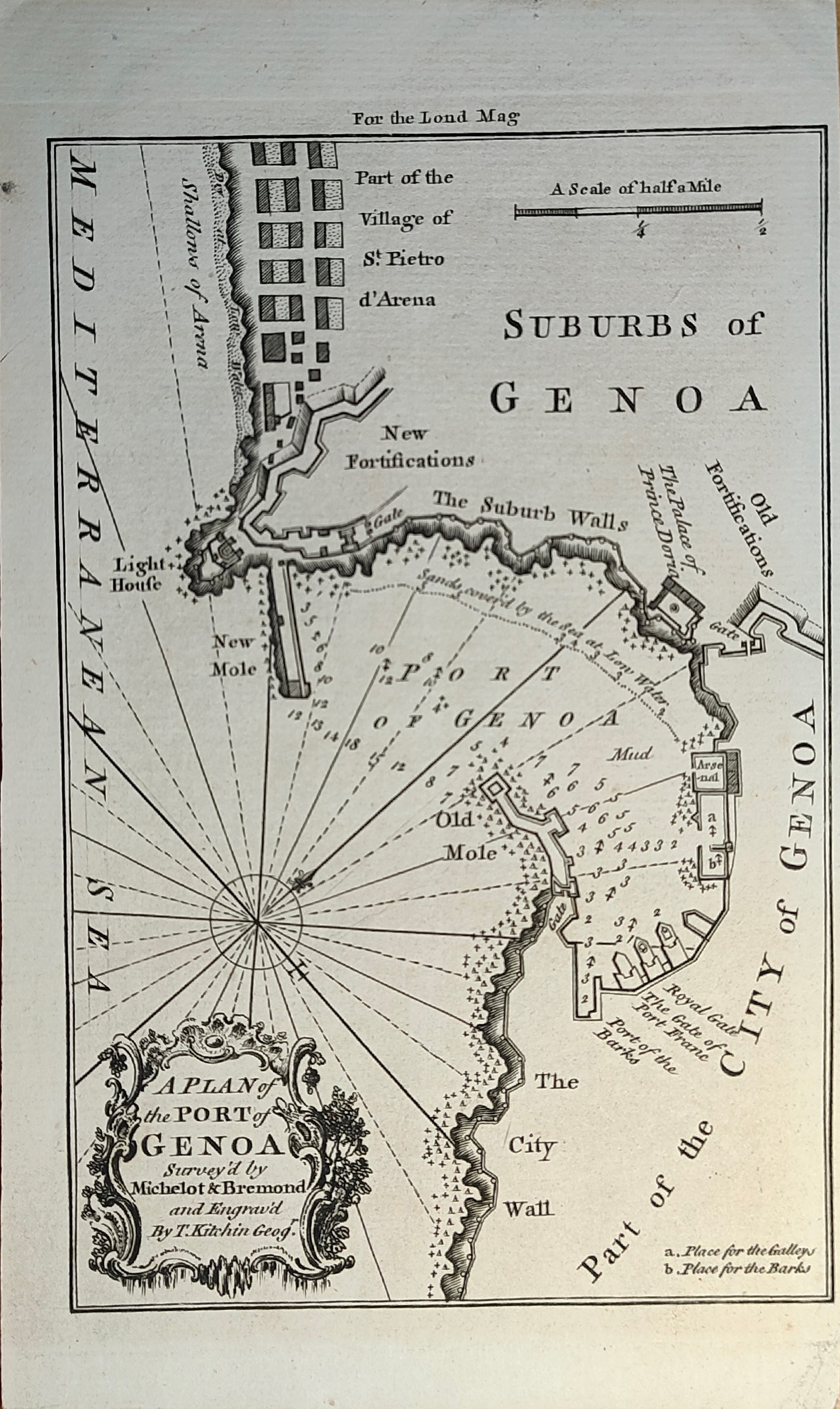
Map title
A plan of the port of Genoa
Author
Michelot
Location shown in map
Genoa
Edition date
Circa 1720
Edition place
London
Editor
Atlas
London Magazine
Price
150 Euro
State
[mint/EXCELLENT/very good/good/fair/mediocre/poor]
Color
Black/white
Verso
Blank
Size
Plate: cm (11 x 17) inches (4.33 x 6.69) Paper: cm (13 x 21) inches (5.12 x 8.27)
Technique
Copper engraving
Note
Reference
Wiki
Here for more info
In stock
Available
Info
info@thetreasuremaps.com
Code
#1360
×
![A plan of the port of Genoa by Michelot, Genoa, Circa 1720]()
Map title
L'Italie dressee sur les Observations
Author
De L'Isle
Location shown in map
Italy
Edition date
Circa 1720
Edition place
Amsterdam
Editor
Mortier
Atlas
Atlas de Geographie
Price
300 Euro
State
[mint/EXCELLENT/very good/good/fair/mediocre/poor]
Color
Old colors
Verso
Blank
Size
Plate: cm (60 x 49) inches (23.62 x 19.29) Paper: cm (66 x 52) inches (25.98 x 20.47)
Technique
Copper engraving
Note
Reference
R.Borri L'Italia nelle antiche carte pag.214
Wiki
Here for more info
In stock
Available
Info
info@thetreasuremaps.com
Code
#1357
×
![L'Italie dressee sur les Observations by De L'Isle, Italy, Circa 1720]()
Map title
Isle de Ladrones
Author
Unknown
Location shown in map
Marianne island
Edition date
Circa 1722
Edition place
Amsterdam
Editor
F.Bernard
Atlas
Recueil des voyages qui ont servi a ...
Price
150 Euro
State
[MINT/excellent/very good/good/fair/mediocre/poor]
Color
Black/white
Verso
Blank
Size
Plate: cm (20.3 x 15.2) inches (7.99 x 5.98) Paper: cm (22.9 x 15.2) inches (9.02 x 5.98)
Technique
Copper engraving
Note
--
Reference
--
Wiki
Here for more info
In stock
Available
Info
info@thetreasuremaps.com
Code
#0593
×
![Isle de Ladrones by Unknown, Marianne island, Circa 1722]()
Map title
Northumberland
Author
Morden
Location shown in map
Northumberland
Edition date
1722
Edition place
London
Editor
Atlas
Price
100 Euro
State
[mint/excellent/VERY GOOD/good/fair/mediocre/poor]
Color
Old colors
Verso
Blank
Size
Plate: cm (36 x 42) inches (14.17 x 16.54) Paper: cm (36 x 42) inches (14.17 x 16.54)
Technique
Copper engraving
Note
Reference
Wiki
Here for more info
In stock
Available
Info
info@thetreasuremaps.com
Code
#1362
Northumberland
Author
Morden
Location shown in map
Northumberland
Edition date
1722
Edition place
London
Editor
Atlas
Price
100 Euro
State
[mint/excellent/VERY GOOD/good/fair/mediocre/poor]
Color
Old colors
Verso
Blank
Size
Plate: cm (36 x 42) inches (14.17 x 16.54) Paper: cm (36 x 42) inches (14.17 x 16.54)
Technique
Copper engraving
Note
Reference
Wiki
Here for more info
In stock
Available
Info
info@thetreasuremaps.com
Code
#1362
×
![Northumberland by Morden, Northumberland, 1722]()
Map title
Episcopatus Dunelmenis
Author
Morden
Location shown in map
Dunelmenis
Edition date
1722
Edition place
London
Editor
Atlas
Price
100 Euro
State
[mint/excellent/VERY GOOD/good/fair/mediocre/poor]
Color
Old colors
Verso
Blank
Size
Plate: cm (42 x 36) inches (16.54 x 14.17) Paper: cm (42 x 36) inches (16.54 x 14.17)
Technique
Copper engraving
Note
Reference
Wiki
Here for more info
In stock
Available
Info
info@thetreasuremaps.com
Code
#1363
×
![Episcopatus Dunelmenis by Morden, Dunelmenis, 1722]()
Map title
Author
Location shown in map
South Italy
Edition date
Circa 1723
Edition place
Editor
Atlas
Opera omnia medico pratica
Price
150 Euro
State
[mint/EXCELLENT/very good/good/fair/mediocre/poor]
Color
Black/white
Verso
Size
Plate: cm (13 x 20) inches (5.12 x 7.87) Paper: cm (13 x 20) inches (5.12 x 7.87)
Technique
Copper engraving
Note
Framed
Reference
Wiki
Here for more info
In stock
Sold
Info
info@thetreasuremaps.com
Code
#1114
×
![by , South Italy, Circa 1723]()
Map title
Asia Vetus
Author
Weigel
Location shown in map
Asia
Edition date
1725
Edition place
Nuremberg
Editor
--
Atlas
--
Price
200 Euro
State
[mint/excellent/VERY GOOD/good/fair/mediocre/poor]
Color
Old colors
Verso
Blank
Size
Plate: cm (38.1 x 30.5) inches (15 x 12.01) Paper: cm (45.7 x 35.6) inches (17.99 x 14.02)
Technique
Copper engraving
Note
--
Reference
--
Wiki
Here for more info
In stock
Available
Info
info@thetreasuremaps.com
Code
#0601
×
![Asia Vetus by Weigel, Asia, 1725]()

Map title
L' Asia
Author
Sanson
Location shown in map
Asia
Edition date
Circa 1725
Edition place
Venice
Editor
Atlas
Price
125 Euro
State
[mint/EXCELLENT/very good/good/fair/mediocre/poor]
Color
Black/white
Verso
Blank
Size
Plate: cm (17 x 17) inches (6.69 x 6.69) Paper: cm (16 x 14) inches (6.3 x 5.51)
Technique
Copper engraving
Note
Reference
Wiki
Here for more info
In stock
Available
Info
info@thetreasuremaps.com
Code
#1190
×
![L' Asia by Sanson, Asia, Circa 1725]()
Map title
Trino
Author
Blaeu
Location shown in map
Trino
Edition date
1725
Edition place
Paris
Editor
Le Haye
Atlas
Theatrum statuum regiae celsitudinis Sabaudiae
Price
Please ask: info@thetreasuremaps.com
State
[mint/EXCELLENT/very good/good/fair/mediocre/poor]
Color
Black/white
Verso
Blank
Size
Plate: cm (58.4 x 50.8) inches (22.99 x 20) Paper: cm (68.6 x 55.9) inches (27.01 x 22.01)
Technique
Copper engraving
Note
No particular notes for this maps.
Reference
--
Wiki
Here for more info
In stock
Available
Info
info@thetreasuremaps.com
Code
#0578
Trino
Author
Blaeu
Location shown in map
Trino
Edition date
1725
Edition place
Paris
Editor
Le Haye
Atlas
Theatrum statuum regiae celsitudinis Sabaudiae
Price
Please ask: info@thetreasuremaps.com
State
[mint/EXCELLENT/very good/good/fair/mediocre/poor]
Color
Black/white
Verso
Blank
Size
Plate: cm (58.4 x 50.8) inches (22.99 x 20) Paper: cm (68.6 x 55.9) inches (27.01 x 22.01)
Technique
Copper engraving
Note
No particular notes for this maps.
Reference
--
Wiki
Here for more info
In stock
Available
Info
info@thetreasuremaps.com
Code
#0578
×
![Trino by Blaeu, Trino, 1725]()
Map title
Tabula Italiae medii evi
Author
Giovanni Giacomo Spinelli
Location shown in map
Italy
Edition date
1727
Edition place
Venice
Editor
Atlas
Price
1000 Euro
State
[mint/EXCELLENT/very good/good/fair/mediocre/poor]
Color
Black/white
Verso
Blank
Size
Plate: cm (74 x 51) inches (29.13 x 20.08) Paper: cm (73 x 50) inches (28.74 x 19.69)
Technique
Copper engraving
Note
First italian engraved map by a woman
Reference
R.Borri L'Italia nelle antiche carte pag.216
Wiki
Here for more info
In stock
Available
Info
info@thetreasuremaps.com
Code
#1056
×
![Tabula Italiae medii evi by Giovanni Giacomo Spinelli, Italy, 1727]()
Map title
Nova et Exactissima Totius Italiae Sardiniae et Corsicae Delineatio
Author
Seutter, Matthaus
Location shown in map
Italy
Edition date
Circa 1730
Edition place
Augsburg
Editor
--
Atlas
Atlas Novus sive Tabulae Geographicae totius orbis faciem, partes, imperia, regna et provincias exhibentes exactissima cura iuxta recontissimas observation
Price
Please ask: info@thetreasuremaps.com
State
[mint/EXCELLENT/very good/good/fair/mediocre/poor]
Color
Old color
Verso
Blank
Size
Plate: cm (57 x 49) inches (22.44 x 19.29) Paper: cm (62.2 x 54) inches (24.49 x 21.26)
Technique
Copper engraving
Note
Reference
R.Borri L'Italia nelle antiche carte pag.193
Wiki
Here for more info
In stock
Available
Info
info@thetreasuremaps.com
Code
#0820
×
![Nova et Exactissima Totius Italiae Sardiniae et Corsicae Delineatio by Seutter, Matthaus, Italy, Circa 1730]()
Map title
La Gran Bretagna e l'Irlanda
Author
Unknown
Location shown in map
British Isles
Edition date
1730
Edition place
???
Editor
--
Atlas
--
Price
125 Euro
State
[mint/excellent/VERY GOOD/good/fair/mediocre/poor]
Color
Black/white
Verso
Blank
Size
Plate: cm (15.2 x 12.7) inches (5.98 x 5) Paper: cm (18.4 x 15.9) inches (7.24 x 6.26)
Technique
Copper engraving
Note
No particular notes for this maps
Reference
--
Wiki
Here for more info
In stock
Available
Info
info@thetreasuremaps.com
Code
#0145
×
![La Gran Bretagna e l'Irlanda by Unknown, British Isles, 1730]()
Map title
L'Italia con le sue Poste e strade principali
Author
Cantelli da Vignola
Location shown in map
Italy
Edition date
Circa 1730
Edition place
Augsburg
Editor
Seutter
Atlas
Price
500 Euro
State
[mint/excellent/very good/GOOD/fair/mediocre/poor]
Color
Old colors
Verso
Blank
Size
Plate: cm (57 x 49) inches (22.44 x 19.29) Paper: cm (64 x 56) inches (25.2 x 22.05)
Technique
Copper engraving
Note
Reference
R.Borri L'Italia nelle antiche carte pag.191
Wiki
Here for more info
In stock
Available
Info
info@thetreasuremaps.com
Code
#1167
×
![L'Italia con le sue Poste e strade principali by Cantelli da Vignola, Italy, Circa 1730]()