1700-1799
Map title
La Gran Bretagna e l'Irlanda
Author
Unknown
Location shown in map
British Isles
Edition date
1730
Edition place
???
Editor
--
Atlas
--
Price
125 Euro
State
[mint/excellent/VERY GOOD/good/fair/mediocre/poor]
Color
Black/white
Verso
Blank
Size
Plate: cm (15.2 x 12.7) inches (5.98 x 5) Paper: cm (18.4 x 15.9) inches (7.24 x 6.26)
Technique
Copper engraving
Note
No particular notes for this maps
Reference
--
Wiki
Here for more info
In stock
Available
Info
info@thetreasuremaps.com
Code
#0145
×
![La Gran Bretagna e l'Irlanda by Unknown, British Isles, 1730]()
Map title
Bohemia regnum
Author
Seutter, Matthaus
Location shown in map
Bohemia
Edition date
1730
Edition place
Augsburg
Editor
--
Atlas
--
Price
250 Euro
State
[mint/excellent/very good/GOOD/fair/mediocre/poor]
Color
Old color
Verso
Blank
Size
Plate: cm (55.9 x 49.5) inches (22.01 x 19.49) Paper: cm (58.4 x 52.1) inches (22.99 x 20.51)
Technique
Copper engraving
Note
No particular notes for this maps
Reference
--
Wiki
Here for more info
In stock
Available
Info
info@thetreasuremaps.com
Code
#0148
×
![Bohemia regnum by Seutter, Matthaus, Bohemia, 1730]()

Map title
Nuova carta del ducato di Brabante,Limburgo e della Geldria super.re
Author
Unknown
Location shown in map
Luxembourg
Edition date
1730
Edition place
Amsterdam
Editor
--
Atlas
Nieuwe en beknopte hand-atlas.
Price
Please ask: info@thetreasuremaps.com
State
[mint/excellent/VERY GOOD/good/fair/mediocre/poor]
Color
Old outlined
Verso
Blank
Size
Plate: cm (33 x 27.9) inches (12.99 x 10.98) Paper: cm (38.1 x 30.5) inches (15 x 12.01)
Technique
Copper engraving
Note
No particular notes for this maps
Reference
--
Wiki
Here for more info
In stock
Sold
Info
info@thetreasuremaps.com
Code
#0150
×
![Nuova carta del ducato di Brabante,Limburgo e della Geldria super.re by Unknown, Luxembourg, 1730]()
Map title
Ducatus Mediolanensis cum adjacentibus principat. et dominii
Author
Seutter, Matthaus
Location shown in map
Mediolanum Ducatus, North west Italy
Edition date
1730
Edition place
Augsburg
Editor
--
Atlas
Atlas Minor
Price
Please ask: info@thetreasuremaps.com
State
[mint/excellent/VERY GOOD/good/fair/mediocre/poor]
Color
Old color
Verso
Blank
Size
Plate: cm (25.4 x 19) inches (10 x 7.48) Paper: cm (29.2 x 21.6) inches (11.5 x 8.5)
Technique
Copper engraving
Note
No particular notes for this maps
Reference
--
Wiki
Here for more info
In stock
Sold
Info
info@thetreasuremaps.com
Code
#0425
×
![Ducatus Mediolanensis cum adjacentibus principat. et dominii by Seutter, Matthaus, Mediolanum Ducatus, North west Italy, 1730]()
Map title
Arabia Petraea et Deserta
Author
Unknown
Location shown in map
Israel and Arabia
Edition date
1732
Edition place
Leipzig
Editor
--
Atlas
Geographia Antiqua
Price
Please ask: info@thetreasuremaps.com
State
[mint/EXCELLENT/very good/good/fair/mediocre/poor]
Color
Black/white
Verso
Blank
Size
Plate: cm (30.5 x 20.3) inches (12.01 x 7.99) Paper: cm (36.8 x 24.1) inches (14.49 x 9.49)
Technique
Copper engraving
Note
No particular notes for this maps
Reference
--
Wiki
Here for more info
In stock
Sold
Info
info@thetreasuremaps.com
Code
#0221
×
![Arabia Petraea et Deserta by Unknown, Israel and Arabia, 1732]()
Map title
America Meridionalis
Author
Henri du Sauzet
Location shown in map
South America
Edition date
1734
Edition place
Amsterdam
Editor
Henri du Sauzet
Atlas
Atlas Portatif
Price
300 Euro
State
[MINT/excellent/very good/good/fair/mediocre/poor]
Color
Black/white
Verso
Blank
Size
Plate: cm (25 x 18) inches (9.84 x 7.09) Paper: cm (37 x 25) inches (14.57 x 9.84)
Technique
Copper engraving
Note
No particular notes for this maps.
Reference
--
Wiki
Here for more info
In stock
Available
Info
info@thetreasuremaps.com
Code
#0702
×
![America Meridionalis by Henri du Sauzet, South America, 1734]()
Map title
Le cours du po dans le Piemont et le Monferrat
Author
Placide de Sainte-Helene
Location shown in map
North-West Italy
Edition date
1734
Edition place
Amsterdam
Editor
Atlas
Price
250 Euro
State
[mint/EXCELLENT/very good/good/fair/mediocre/poor]
Color
Black/white
Verso
Blank
Size
Plate: cm (50 x 41) inches (19.69 x 16.14) Paper: cm (65 x 52) inches (25.59 x 20.47)
Technique
Copper engraving
Note
Reference
Wiki
Here for more info
In stock
Available
Info
info@thetreasuremaps.com
Code
#1084
×
![Le cours du po dans le Piemont et le Monferrat by Placide de Sainte-Helene, North-West Italy, 1734]()
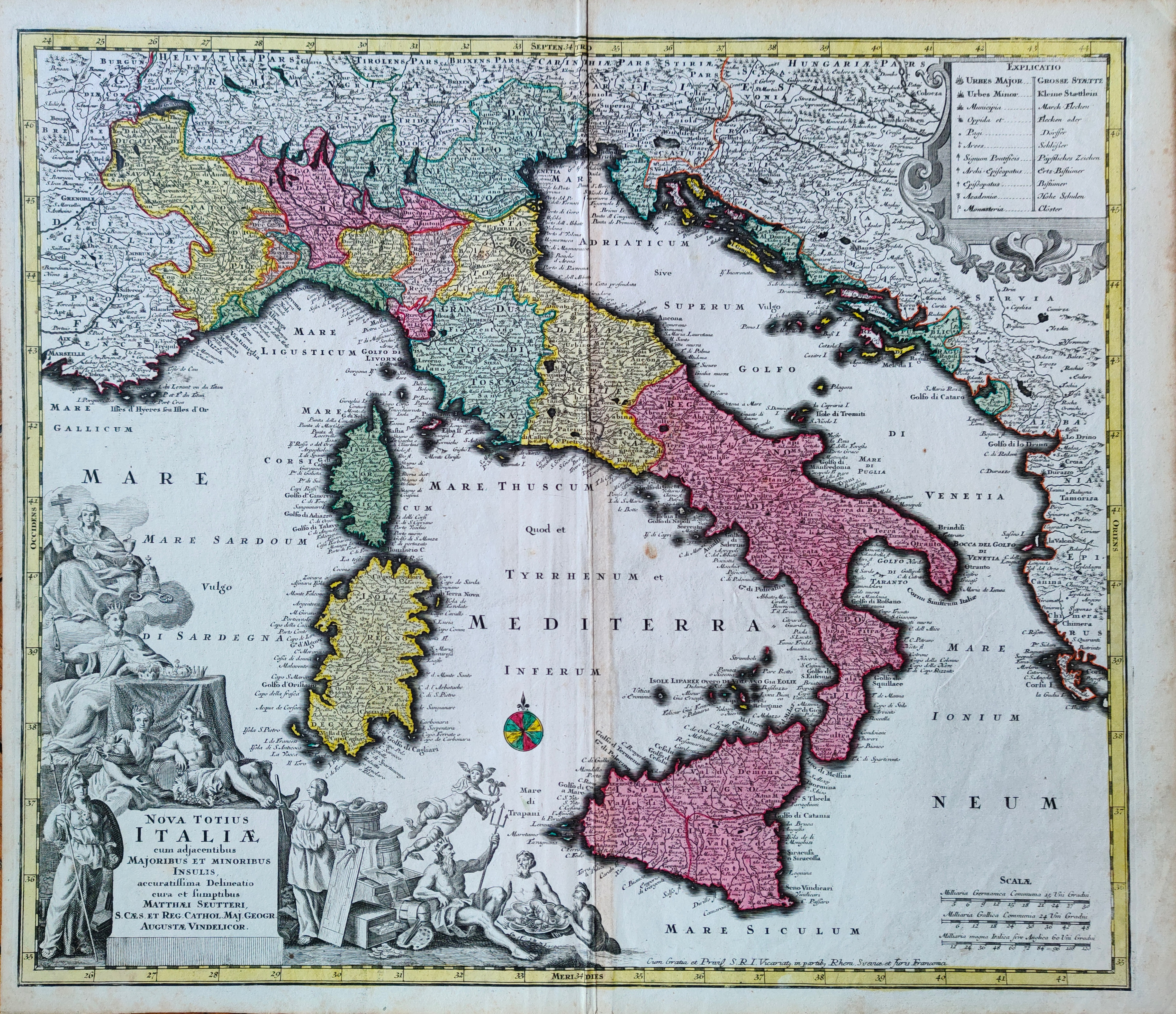
Map title
Nova totius Italiae
Author
Seutter, Matthaus
Location shown in map
Italy
Edition date
Circa 1735
Edition place
Augsburg
Editor
Atlas
Atlas Novus sive Tabulae Geographicae totius orbis faciem, partes, imperia, regna et provincias exhibentes exactissima cura iuxta recontissimas observation
Price
500 Euro
State
[mint/EXCELLENT/very good/good/fair/mediocre/poor]
Color
Old colors
Verso
Blank
Size
Plate: cm (57 x 49) inches (22.44 x 19.29) Paper: cm (60 x 53) inches (23.62 x 20.87)
Technique
Copper engraving
Note
Reference
R.Borri L'Italia nelle antiche carte pag.195
Wiki
Here for more info
In stock
Available
Info
info@thetreasuremaps.com
Code
#1258
×
![Nova totius Italiae by Seutter, Matthaus, Italy, Circa 1735]()

Map title
Cursus Fluminis Padi vel Po per Longobardiam
Author
Homann
Location shown in map
Liguria
Edition date
1735
Edition place
Editor
Atlas
Atlas compendiarius
Price
300 Euro
State
[mint/EXCELLENT/very good/good/fair/mediocre/poor]
Color
Old colors
Verso
Blank
Size
Plate: cm (60 x 54) inches (23.62 x 21.26) Paper: cm (58 x 50) inches (22.83 x 19.69)
Technique
Copper engraving
Note
Reference
Wiki
Here for more info
In stock
Available
Info
info@thetreasuremaps.com
Code
#1228
×
![Cursus Fluminis Padi vel Po per Longobardiam by Homann, Liguria, 1735]()
Map title
Nuova Carta Del Polo Artico secondo l'ultime osservazioni a Amsterdam da Isac Tirion
Author
Tirion
Location shown in map
Polar Arctic Regions
Edition date
1736
Edition place
Amsterdam
Editor
--
Atlas
--
Price
300 Euro
State
mint/excellent/VERY GOOD/good/fair/mediocre/poor]
Color
Black/white
Verso
Blank
Size
Plate: cm (35.6 x 30.5) inches (14.02 x 12.01) Paper: cm (45.7 x 38.1) inches (17.99 x 15)
Technique
Copper engraving
Note
California as an island
Reference
--
Wiki
Here for more info
In stock
Available
Info
info@thetreasuremaps.com
Code
#0329
×
![Nuova Carta Del Polo Artico secondo l'ultime osservazioni a Amsterdam da Isac Tirion by Tirion, Polar Arctic Regions, 1736]()
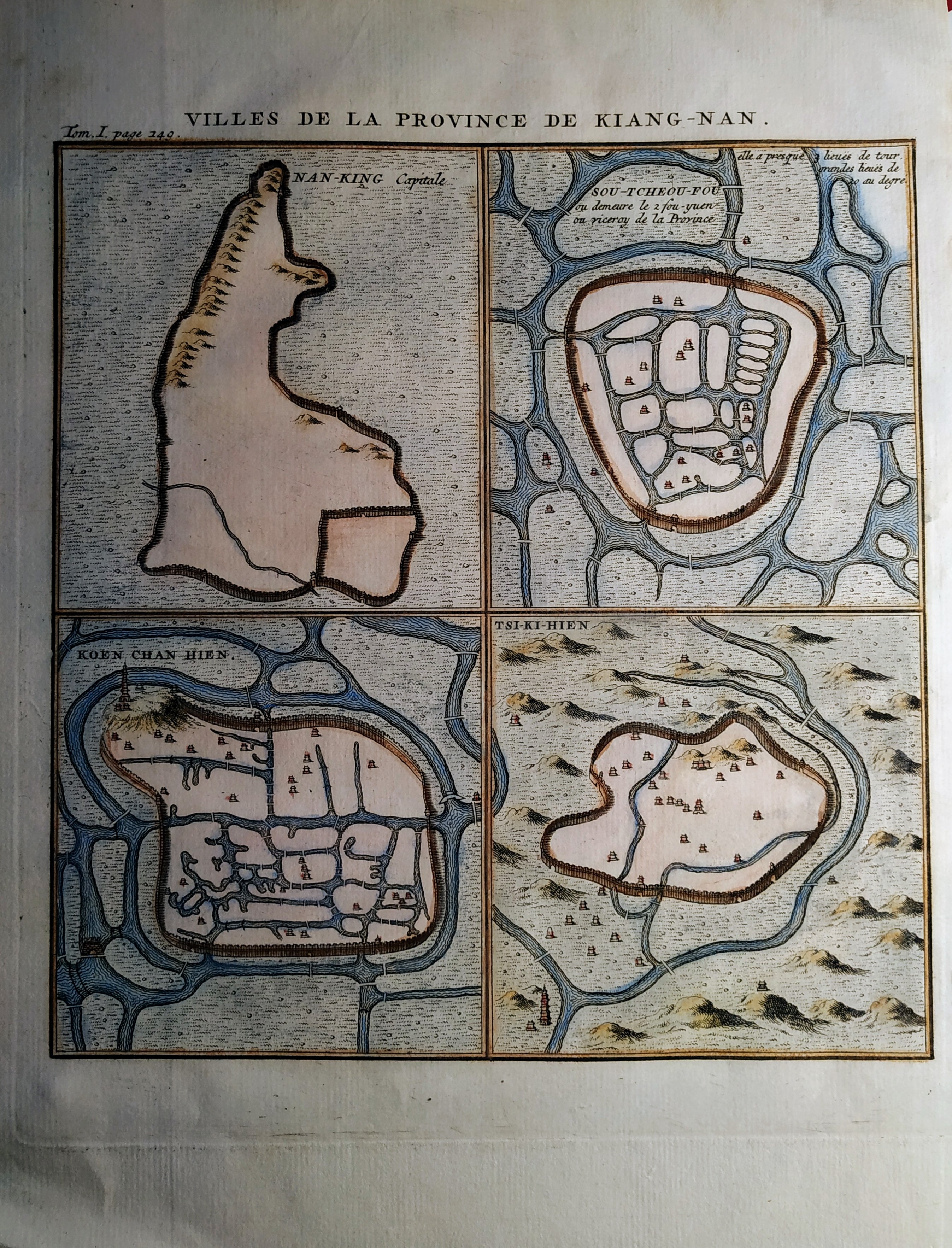
Map title
Villes de la Province de Kiang-Nan
Author
Henri Scheurleer
Location shown in map
Jangsung
Edition date
1736
Edition place
The Haugue
Editor
Atlas
Description de la Chine
Price
50 Euro
State
[mint/EXCELLENT/very good/good/fair/mediocre/poor]
Color
Old colors
Verso
Blank
Size
Plate: cm (17 x 19) inches (6.69 x 7.48) Paper: cm (20 x 26) inches (7.87 x 10.24)
Technique
Copper engraving
Note
No particular notes for this maps
Reference
Wiki
Here for more info
In stock
Available
Info
info@thetreasuremaps.com
Code
#0704
×
![Villes de la Province de Kiang-Nan by Henri Scheurleer, Jangsung, 1736]()
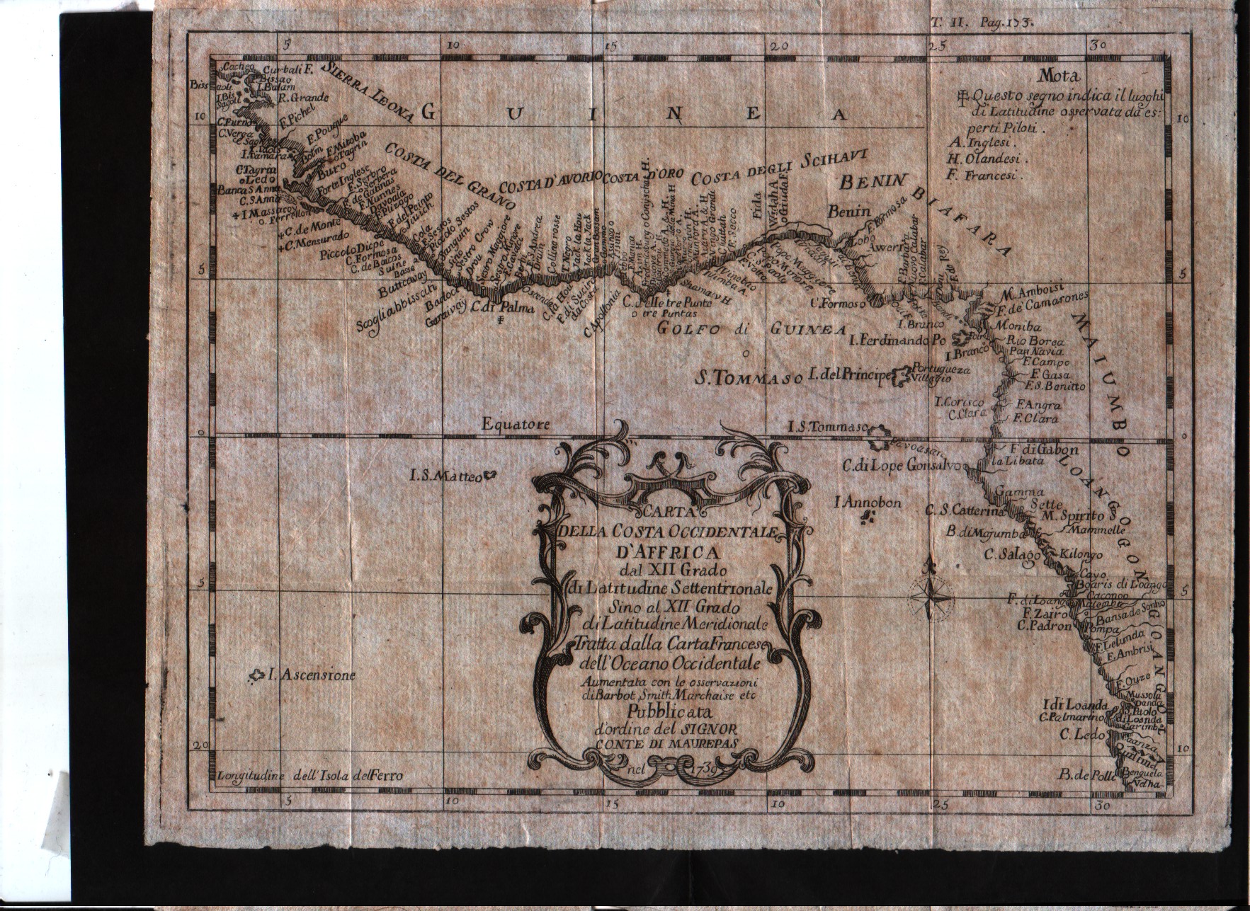
Map title
Carta della costa occidentale d'Affrica dal XII grado di latitudine settentrionale sino al XII grado di latitudine meridionale.
Author
Bellin
Location shown in map
West Africa
Edition date
1739
Edition place
--
Editor
--
Atlas
--
Price
100 Euro
State
[mint/excellent/VERY GOOD/good/fair/mediocre/poor]
Color
Black/white
Verso
Blank
Size
Plate: cm (24.1 x 19) inches (9.49 x 7.48) Paper: cm (26 x 21) inches (10.24 x 8.27)
Technique
Copper engraving
Note
The map is signed as to be printed by an order of Conte di Maurepas.
Reference
--
Wiki
Here for more info
In stock
Available
Info
info@thetreasuremaps.com
Code
#0451
×
![Carta della costa occidentale d'Affrica dal XII grado di latitudine settentrionale sino al XII grado di latitudine meridionale. by Bellin, West Africa, 1739]()
Map title
Costa occidentale d'Affrica dal XI grado di latitudine settentrionale sino al capo di Buona Speranza.
Author
Bellin
Location shown in map
West Africa
Edition date
1739
Edition place
--
Editor
--
Atlas
--
Price
Please ask: info@thetreasuremaps.com
State
[mint/excellent/VERY GOOD/good/fair/mediocre/poor]
Color
Black/white
Verso
Blank
Size
Plate: cm (25.4 x 22.9) inches (10 x 9.02) Paper: cm (26.7 x 25.4) inches (10.51 x 10)
Technique
Copper engraving
Note
The map is signed as to be printed by an order of Conte di Maurepas.
Reference
--
Wiki
Here for more info
In stock
Available
Info
info@thetreasuremaps.com
Code
#0299
×
![Costa occidentale d'Affrica dal XI grado di latitudine settentrionale sino al capo di Buona Speranza. by Bellin, West Africa, 1739]()
Map title
L'Italia con le sue Poste e strade principali
Author
Cantelli da Vignola
Location shown in map
Italy
Edition date
1740
Edition place
Venice
Editor
Bagozi
Atlas
Price
500 Euro
State
[mint/EXCELLENT/very good/good/fair/mediocre/poor]
Color
Black/white
Verso
Blank
Size
Plate: cm (55 x 44) inches (21.65 x 17.32) Paper: cm (57 x 46) inches (22.44 x 18.11)
Technique
Copper engraving
Note
Reference
R.Borri L'Italia nelle antiche carte pag.161
Wiki
Here for more info
In stock
Available
Info
info@thetreasuremaps.com
Code
#0990
×
![L'Italia con le sue Poste e strade principali by Cantelli da Vignola, Italy, 1740]()
Map title
A view of Casal
Author
Paul de Rapin de Thoyras
Location shown in map
Casal
Edition date
1740
Edition place
London
Editor
Atlas
Price
200 Euro
State
[mint/EXCELLENT/very good/good/fair/mediocre/poor]
Color
Black/white
Verso
Blank
Size
Plate: cm (40 x 37) inches (15.75 x 14.57) Paper: cm (50 x 49) inches (19.69 x 19.29)
Technique
Copper engraving
Note
Reference
Wiki
Here for more info
In stock
Available
Info
info@thetreasuremaps.com
Code
#0785
×
![A view of Casal by Paul de Rapin de Thoyras, Casal, 1740]()
Map title
Nuova carta dell'Asia
Author
Tirion
Location shown in map
Asia
Edition date
Circa 1740
Edition place
Venice
Editor
Albizzi
Atlas
Atlante novissimo
Price
250 Euro
State
[mint/excellent/VERY GOOD/good/fair/mediocre/poor]
Color
Black/white
Verso
Blank
Size
Plate: cm (43.2 x 33) inches (17.01 x 12.99) Paper: cm (48.3 x 36.8) inches (19.02 x 14.49)
Technique
Copper engraving
Note
Reference
--
Wiki
Here for more info
In stock
Available
Info
info@thetreasuremaps.com
Code
#1148
×
![Nuova carta dell'Asia by Tirion, Asia, Circa 1740]()
Map title
Nuova carta della Tartaria
Author
Tirion
Location shown in map
East Asia
Edition date
1740
Edition place
Amsterdam
Editor
--
Atlas
Atlante Novissimo. Giambattista Albrizzi
Price
150 Euro
State
[mint/excellent/VERY GOOD/good/fair/mediocre/poor]
Color
Black/white
Verso
Blank
Size
Plate: cm (33 x 27.9) inches (12.99 x 10.98) Paper: cm (48.3 x 38.1) inches (19.02 x 15)
Technique
Copper engraving
Note
No particular notes for this maps
Reference
--
Wiki
Here for more info
In stock
Available
Info
info@thetreasuremaps.com
Code
#0222
×
![Nuova carta della Tartaria by Tirion, East Asia, 1740]()
Map title
Le colonie degli europei in America
Author
Ricciardo
Location shown in map
America
Edition date
1740
Edition place
Amsterdam
Editor
Francesco Ricciardo
Atlas
Lo spettacolo della natura esposto in varj trattati
Price
75 Euro
State
[mint/EXCELLENT/very good/good/fair/mediocre/poor]
Color
Black/white
Verso
Blank
Size
Plate: cm (7 x 14) inches (2.76 x 5.51) Paper: cm (12 x 18) inches (4.72 x 7.09)
Technique
Copper engraving
Note
Reference
Wiki
Here for more info
In stock
Available
Info
info@thetreasuremaps.com
Code
#1090
×
![Le colonie degli europei in America by Ricciardo, America, 1740]()
Map title
Mappamondo o sia descrizione generale del globo terrestre ed acquatico
Author
Albrizzi
Location shown in map
World
Edition date
Circa 1740
Edition place
Venice
Editor
Atlas
Price
600 Euro
State
[mint/EXCELLENT/very good/good/fair/mediocre/poor]
Color
Black/white
Verso
Blank
Size
Plate: cm (36 x 30) inches (14.17 x 11.81) Paper: cm (47 x 37) inches (18.5 x 14.57)
Technique
Copper engraving
Note
Reference
Wiki
Here for more info
In stock
Available
Info
info@thetreasuremaps.com
Code
#1359
×
![Mappamondo o sia descrizione generale del globo terrestre ed acquatico by Albrizzi, World, Circa 1740]()
Map title
Republicae Genuensis dominium
Author
Seutter, Matthaus
Location shown in map
Liguria
Edition date
1740
Edition place
Augsburg
Editor
Atlas
Atlas Novus sive Tabulae Geographicae totius orbis faciem, partes, imperia, regna et provincias exhibentes exactissima cura iuxta recontissimas observation
Price
500 Euro
State
[mint/excellent/VERY GOOD/good/fair/mediocre/poor]
Color
Old colors
Verso
Blank
Size
Plate: cm (58 x 48) inches (22.83 x 18.9) Paper: cm (67 x 54) inches (26.38 x 21.26)
Technique
Copper engraving
Note
Reference
Wiki
Here for more info
In stock
Available
Info
info@thetreasuremaps.com
Code
#0911
×
![Republicae Genuensis dominium by Seutter, Matthaus, Liguria, 1740]()