1700-1799
Map title
Carte de l'Etat de Genes, ou se trouvent les environs de Savone partie du Marquisat de Finale du Piemont.
Author
Robert de Vaugondy
Location shown in map
Liguria
Edition date
1748
Edition place
Paris
Editor
Durand & Pissot
Atlas
Atlas portatif universel et militaire
Price
150 Euro
State
[MINT/excellent/very good/good/fair/mediocre/poor]
Color
Old colors
Verso
Blank
Size
Plate: cm (20.3 x 15.2) inches (7.99 x 5.98) Paper: cm (24.1 x 19) inches (9.49 x 7.48)
Technique
Copper engraving
Note
No particular notes for this maps.
Reference
--
Wiki
Here for more info
In stock
Available
Info
info@thetreasuremaps.com
Code
#0554
×
![Carte de l'Etat de Genes, ou se trouvent les environs de Savone partie du Marquisat de Finale du Piemont. by Robert de Vaugondy, Liguria, 1748]()
Map title
Amerique Meridionale
Author
Robert de Vaugondy
Location shown in map
South America
Edition date
1748
Edition place
Paris
Editor
--
Atlas
Atlas Portatif Universel et Militaire
Price
50 Euro
State
[mint/EXCELLENT/very good/good/fair/mediocre/poor]
Color
Old colors
Verso
Blank
Size
Plate: cm (20 x 16) inches (7.87 x 6.3) Paper: cm (23 x 18) inches (9.06 x 7.09)
Technique
Copper engraving
Note
Reference
--
Wiki
Here for more info
In stock
Available
Info
info@thetreasuremaps.com
Code
#1004
×
![Amerique Meridionale by Robert de Vaugondy, South America, 1748]()

Map title
Carte de la Perse
Author
Cellarius
Location shown in map
South west Asia
Edition date
1748
Edition place
--
Editor
--
Atlas
Geographia Antiqua
Price
Please ask: info@thetreasuremaps.com
State
[mint/EXCELLENT/very good/good/fair/mediocre/poor]
Color
Old outlined
Verso
Blank
Size
Plate: cm (34.3 x 25.4) inches (13.5 x 10) Paper: cm (39.4 x 26.7) inches (15.51 x 10.51)
Technique
Copper engraving
Note
Beautifull map of south Asia. Old India but new Caspian sea.
Reference
--
Wiki
Here for more info
In stock
Sold
Info
info@thetreasuremaps.com
Code
#0391
×
![Carte de la Perse by Cellarius, South west Asia, 1748]()
Map title
La Palestine
Author
Le Rouge
Location shown in map
--
Edition date
1748
Edition place
Paris
Editor
--
Atlas
Atlas Nouveau Portatif l'usage des militaries et du voyageur
Price
Please ask: info@thetreasuremaps.com
State
[mint/EXCELLENT/very good/good/fair/mediocre/poor]
Color
Old outlined
Verso
Blank
Size
Plate: cm (20.3 x 27.9) inches (7.99 x 10.98) Paper: cm (24.1 x 34.9) inches (9.49 x 13.74)
Technique
Copper engraving
Note
No particular notes for this maps
Reference
--
Wiki
Here for more info
In stock
Sold
Info
info@thetreasuremaps.com
Code
#0392
×
![La Palestine by Le Rouge, --, 1748]()
Map title
Carte de l'etat de Genes
Author
Unknown
Location shown in map
Near Savona in NW Italy
Edition date
1748
Edition place
--
Editor
--
Atlas
--
Price
Please ask: info@thetreasuremaps.com
State
[mint/EXCELLENT/very good/good/fair/mediocre/poor]
Color
Old color
Verso
Blank
Size
Plate: cm (20.3 x 15.2) inches (7.99 x 5.98) Paper: cm (22.9 x 17.8) inches (9.02 x 7.01)
Technique
Copper engraving
Note
No particular notes for this maps
Reference
--
Wiki
Here for more info
In stock
Sold
Info
info@thetreasuremaps.com
Code
#0421
×
![Carte de l'etat de Genes by Unknown, Near Savona in NW Italy, 1748]()
Map title
L'Italie et ses isles ...
Author
Robert de Vaugondy
Location shown in map
Italy
Edition date
1748
Edition place
Paris
Editor
--
Atlas
Atlas Portatif Universel et Militaire
Price
100 Euro
State
[mint/EXCELLENT/very good/good/fair/mediocre/poor]
Color
Modern color
Verso
Blank
Size
Plate: cm (16 x 16) inches (6.3 x 6.3) Paper: cm (28 x 22) inches (11.02 x 8.66)
Technique
Copper engraving
Note
Reference
--
Wiki
Here for more info
In stock
Available
Info
info@thetreasuremaps.com
Code
#0901
×
![L'Italie et ses isles ... by Robert de Vaugondy, Italy, 1748]()
Map title
Isles Moluques
Author
Le Rouge
Location shown in map
--
Edition date
1748
Edition place
Paris
Editor
--
Atlas
Atlas Nouveau Portatif l'usage des militaries et du voyageur
Price
125 Euro
State
[mint/excellent/VERY GOOD/good/fair/mediocre/poor]
Color
Black/white
Verso
Blank
Size
Plate: cm (26.7 x 20.3) inches (10.51 x 7.99) Paper: cm (34.9 x 24.1) inches (13.74 x 9.49)
Technique
Copper engraving
Note
A map depicting European knowledge of Sulawesi, part of Borneo and the Spice Islands at the time of publication.
Reference
--
Wiki
Here for more info
In stock
Available
Info
info@thetreasuremaps.com
Code
#0276
×
![Isles Moluques by Le Rouge, --, 1748]()
Map title
La Parthie et la Perse
Author
Cellarius
Location shown in map
South west Asia
Edition date
1748
Edition place
--
Editor
--
Atlas
Geographia Antiqua
Price
Please ask: info@thetreasuremaps.com
State
[mint/EXCELLENT/very good/good/fair/mediocre/poor]
Color
Old outlined
Verso
Blank
Size
Plate: cm (34.3 x 25.4) inches (13.5 x 10) Paper: cm (39.4 x 31.8) inches (15.51 x 12.52)
Technique
Copper engraving
Note
Beautifull map of south Asia. Old India but new Caspian sea.
Reference
--
Wiki
Here for more info
In stock
Sold
Info
info@thetreasuremaps.com
Code
#0433
×
![La Parthie et la Perse by Cellarius, South west Asia, 1748]()
Map title
Parte meridionale del regno di Napoli
Author
Sanson
Location shown in map
South Italy
Edition date
1748
Edition place
Editor
Atlas
Price
75 Euro
State
[mint/excellent/VERY GOOD/good/fair/mediocre/poor]
Color
Black/white
Verso
Blank
Size
Plate: cm (20 x 16) inches (7.87 x 6.3) Paper: cm (24 x 19) inches (9.45 x 7.48)
Technique
Copper engraving
Note
Reference
--
Wiki
Here for more info
In stock
Available
Info
info@thetreasuremaps.com
Code
#1143
×
![Parte meridionale del regno di Napoli by Sanson, South Italy, 1748]()
Map title
Isles Moluques
Author
Le Rouge
Location shown in map
--
Edition date
1748
Edition place
Paris
Editor
--
Atlas
Atlas Nouveau Portatif l'usage des militaries et du voyageur
Price
125 Euro
State
[mint/EXCELLENT/very good/good/fair/mediocre/poor]
Color
Old colors
Verso
Blank
Size
Plate: cm (26.7 x 20.3) inches (10.51 x 7.99) Paper: cm (34.9 x 24.1) inches (13.74 x 9.49)
Technique
Copper engraving
Note
A map depicting European knowledge of Sulawesi, part of Borneo and the Spice Islands at the time of publication.
Reference
--
Wiki
Here for more info
In stock
Available
Info
info@thetreasuremaps.com
Code
#1152
×
![Isles Moluques by Le Rouge, --, 1748]()
Map title
Parte settentrionale del regno di Napoli
Author
Sanson
Location shown in map
South Italy
Edition date
1748
Edition place
Editor
Atlas
Price
75 Euro
State
[mint/excellent/VERY GOOD/good/fair/mediocre/poor]
Color
Black/white
Verso
Blank
Size
Plate: cm (20 x 16) inches (7.87 x 6.3) Paper: cm (28 x 19) inches (11.02 x 7.48)
Technique
Copper engraving
Note
Reference
--
Wiki
Here for more info
In stock
Available
Info
info@thetreasuremaps.com
Code
#1153
×
![Parte settentrionale del regno di Napoli by Sanson, South Italy, 1748]()
Map title
La sfera artificiale
Author
Location shown in map
Celestial
Edition date
Circa 1748
Edition place
Paris
Editor
Atlas
Price
100 Euro
State
[mint/EXCELLENT/very good/good/fair/mediocre/poor]
Color
Black/white
Verso
Blank
Size
Plate: cm (16 x 14) inches (6.3 x 5.51) Paper: cm (20 x 19) inches (7.87 x 7.48)
Technique
Copper engraving
Note
Reference
Wiki
Here for more info
In stock
Available
Info
info@thetreasuremaps.com
Code
#1154
×
![La sfera artificiale by , Celestial, Circa 1748]()
Map title
Author
Location shown in map
Celestial
Edition date
Circa 1748
Edition place
Paris
Editor
Atlas
Price
100 Euro
State
[mint/EXCELLENT/very good/good/fair/mediocre/poor]
Color
Black/white
Verso
Blank
Size
Plate: cm (16 x 14) inches (6.3 x 5.51) Paper: cm (20 x 19) inches (7.87 x 7.48)
Technique
Copper engraving
Note
Reference
Wiki
Here for more info
In stock
Available
Info
info@thetreasuremaps.com
Code
#1155
×
![by , Celestial, Circa 1748]()
Map title
Author
Homann
Location shown in map
South-east Asia
Edition date
1748
Edition place
Nuremberg
Editor
--
Atlas
--
Price
Please ask: info@thetreasuremaps.com
State
[mint/excellent/VERY GOOD/good/fair/mediocre/poor]
Color
Old color
Verso
Blank
Size
Plate: cm (43.2 x 49.5) inches (17.01 x 19.49) Paper: cm (50.8 x 52.1) inches (20 x 20.51)
Technique
Copper engraving
Note
--
Reference
--
Wiki
Here for more info
In stock
Sold
Info
info@thetreasuremaps.com
Code
#0454
×
![by Homann, South-east Asia, 1748]()
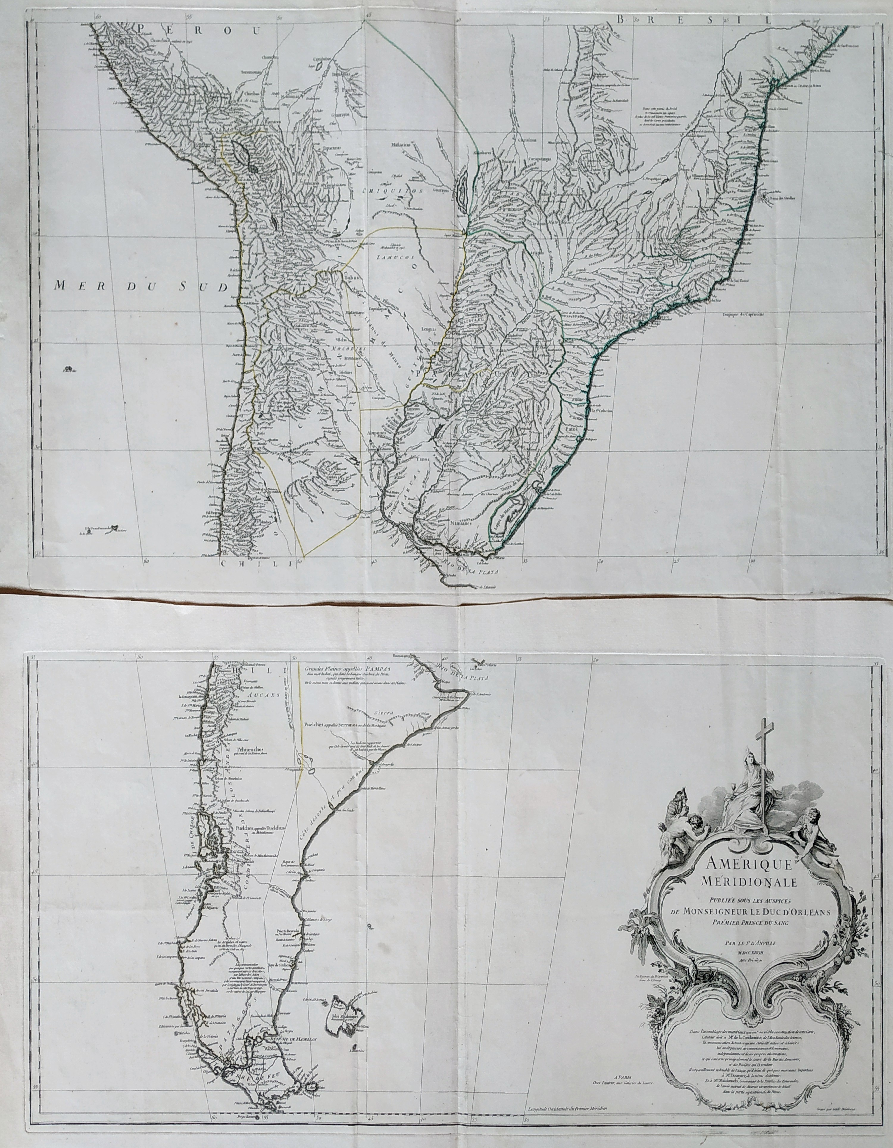
Map title
Amerique Meridionale
Author
Danville
Location shown in map
South America
Edition date
1748
Edition place
Paris
Editor
Atlas
Price
Please ask: info@thetreasuremaps.com
State
[MINT/excellent/very good/good/fair/mediocre/poor]
Color
Black/white
Verso
Blank
Size
Plate: cm (83 x 89) inches (32.68 x 35.04) Paper: cm (0 x 0) inches (0 x 0)
Technique
Copper engraving
Note
Reference
Wiki
Here for more info
In stock
Available
Info
info@thetreasuremaps.com
Code
#0836
×
![Amerique Meridionale by Danville, South America, 1748]()
Map title
L'Angleterre
Author
Le Rouge
Location shown in map
England
Edition date
1748
Edition place
Paris
Editor
--
Atlas
Atlas Nouveau Portatif l'usage des militaries et du voyageur
Price
125 Euro
State
[mint/EXCELLENT/very good/good/fair/mediocre/poor]
Color
Old outlined
Verso
Blank
Size
Plate: cm (20.3 x 27.3) inches (7.99 x 10.75) Paper: cm (20.3 x 27.3) inches (7.99 x 10.75)
Technique
Copper engraving
Note
No particular notes for this maps
Reference
--
Wiki
Here for more info
In stock
Available
Info
info@thetreasuremaps.com
Code
#0156
×
![L'Angleterre by Le Rouge, England, 1748]()
Map title
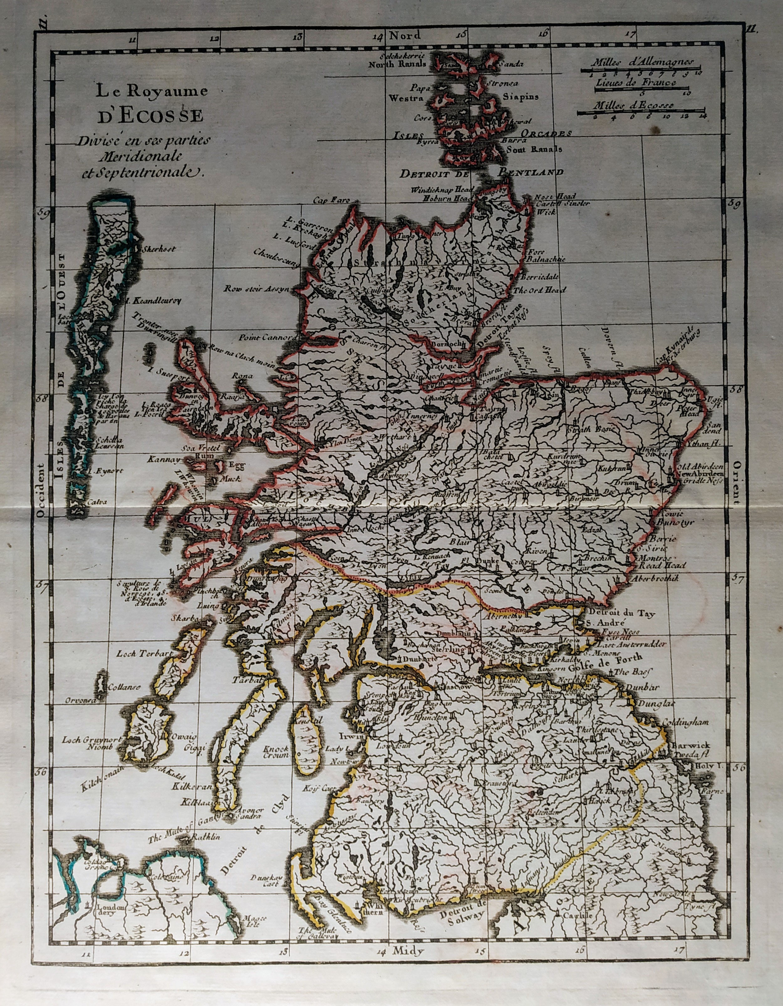
Le Royaume D'Ecosse
Author
Le Rouge
Location shown in map
Scotland
Edition date
1748
Edition place
Paris
Editor
--
Atlas
Atlas Nouveau Portatif l'usage des militaries et du voyageur
Price
125 Euro
State
[mint/EXCELLENT/very good/good/fair/mediocre/poor]
Color
Old outlined
Verso
Blank
Size
Plate: cm (20.3 x 27.3) inches (7.99 x 10.75) Paper: cm (20.3 x 27.3) inches (7.99 x 10.75)
Technique
Copper engraving
Note
No particular notes for this maps
Reference
--
Wiki
Here for more info
In stock
Available
Info
info@thetreasuremaps.com
Code
#0157
×
![Le Royaume D'Ecosse by Le Rouge, Scotland, 1748]()
Map title
Carte des environs de Genes
Author
Vaugondy
Location shown in map
Liguria
Edition date
1748
Edition place
Paris
Editor
Atlas
Price
175 Euro
State
[mint/EXCELLENT/very good/good/fair/mediocre/poor]
Color
Old colors
Verso
Blank
Size
Plate: cm (20 x 15.5) inches (7.87 x 6.1) Paper: cm (24 x 19) inches (9.45 x 7.48)
Technique
Copper engraving
Note
Reference
Wiki
Here for more info
In stock
Available
Info
info@thetreasuremaps.com
Code
#1264
×
![Carte des environs de Genes by Vaugondy, Liguria, 1748]()
Map title
Status Genuensis
Author
Tobias Mayer
Location shown in map
Liguria
Edition date
1749
Edition place
Nuremberg
Editor
Homann
Atlas
Atlas Compendiarius: Quinquaginta Tabularum Geographicarum Homannianarum alias in Atlante maiori contentarum
Price
Please ask: info@thetreasuremaps.com
State
[mint/EXCELLENT/very good/good/fair/mediocre/poor]
Color
Old colors
Verso
Blank
Size
Plate: cm (48 x 39) inches (18.9 x 15.35) Paper: cm (60 x 52) inches (23.62 x 20.47)
Technique
Copper engraving
Note
--
Reference
--
Wiki
Here for more info
In stock
Available
Info
info@thetreasuremaps.com
Code
#0629
×
![Status Genuensis by Tobias Mayer, Liguria, 1749]()
Map title
Italie divisee en regiones par Cesar Auguste
Author
Location shown in map
Italy
Edition date
Circa 1750
Edition place
Paris
Editor
Atlas
Price
175 Euro
State
[mint/EXCELLENT/very good/good/fair/mediocre/poor]
Color
Color
Verso
Blank
Size
Plate: cm (39 x 30) inches (15.35 x 11.81) Paper: cm (43 x 35) inches (16.93 x 13.78)
Technique
Copper engraving
Note
Reference
Wiki
Here for more info
In stock
Available
Info
info@thetreasuremaps.com
Code
#1170
×
![Italie divisee en regiones par Cesar Auguste by , Italy, Circa 1750]()