1700-1799
Map title
Nouvelle cartegeographique dela Suisse
Author
Scheuchzer
Location shown in map
Switzerland
Edition date
Circa 1750
Edition place
Amsterdam
Editor
Wetstein
Atlas
Price
100 Euro
State
[mint/EXCELLENT/very good/good/fair/mediocre/poor]
Color
Black/white
Verso
Blank
Size
Plate: cm (28 x 22) inches (11.02 x 8.66) Paper: cm (33 x 26) inches (12.99 x 10.24)
Technique
Copper engraving
Note
Reference
Wiki
Here for more info
In stock
Available
Info
info@thetreasuremaps.com
Code
#1214
×
![Nouvelle cartegeographique dela Suisse by Scheuchzer, Switzerland, Circa 1750]()

Map title
Carta dell'Africa propriamente detta della Numidia
Author
Unknown
Location shown in map
North Africa
Edition date
1750
Edition place
???
Editor
--
Atlas
Storia romana -- C.Rollin
Price
Please ask: info@thetreasuremaps.com
State
[mint/EXCELLENT/very good/good/fair/mediocre/poor]
Color
Black/white
Verso
Blank
Size
Plate: cm (22.9 x 17.8) inches (9.02 x 7.01) Paper: cm (25.4 x 21.6) inches (10 x 8.5)
Technique
Copper engraving
Note
No particular notes for this maps
Reference
--
Wiki
Here for more info
In stock
Sold
Info
info@thetreasuremaps.com
Code
#0436
×
![Carta dell'Africa propriamente detta della Numidia by Unknown, North Africa, 1750]()
Map title
Carte de l'Angleterre dresse sur de nouvelles observations astronomiques, pour servir l'Historie Universelle
Author
Unknown
Location shown in map
England
Edition date
1750
Edition place
--
Editor
--
Atlas
--
Price
Please ask: info@thetreasuremaps.com
State
[mint/excellent/very good/good/FAIR/mediocre/poor] The map has been repaired. The upper left corner was damaged.
Color
Black/white
Verso
Blank
Size
Plate: cm (21.6 x 29.2) inches (8.5 x 11.5) Paper: cm (22.9 x 33) inches (9.02 x 12.99)
Technique
--
Note
No particular notes for this maps
Reference
--
Wiki
Here for more info
In stock
Sold
Info
info@thetreasuremaps.com
Code
#0169
×
![Carte de l'Angleterre dresse sur de nouvelles observations astronomiques, pour servir l'Historie Universelle by Unknown, England, 1750]()
Map title
Carta dell'Egitto
Author
Unknown
Location shown in map
Egypt
Edition date
1750
Edition place
???
Editor
--
Atlas
Storia romana -- C.Rollin
Price
Please ask: info@thetreasuremaps.com
State
[mint/EXCELLENT/very good/good/fair/mediocre/poor]
Color
Black/white
Verso
Blank
Size
Plate: cm (20.3 x 14) inches (7.99 x 5.51) Paper: cm (25.4 x 15.2) inches (10 x 5.98)
Technique
Copper engraving
Note
No particular notes for this maps
Reference
--
Wiki
Here for more info
In stock
Sold
Info
info@thetreasuremaps.com
Code
#0437
×
![Carta dell'Egitto by Unknown, Egypt, 1750]()
Map title
Viaggio da Mantova a Trento
Author
Location shown in map
North Italy
Edition date
Circa 1750
Edition place
Editor
--
Atlas
Price
250 Euro
State
[mint/EXCELLENT/very good/good/fair/mediocre/poor]
Color
Old colors
Verso
Blank
Size
Plate: cm (18 x 14) inches (7.09 x 5.51) Paper: cm (18 x 14) inches (7.09 x 5.51)
Technique
Manuscript
Note
Manuscript map
Reference
Wiki
Here for more info
In stock
Available
Info
info@thetreasuremaps.com
Code
#1290
×
![Viaggio da Mantova a Trento by , North Italy, Circa 1750]()
Map title
Italie divisee en regiones par Cesar Auguste
Author
Location shown in map
Italy
Edition date
Circa 1750
Edition place
Paris
Editor
Atlas
Price
175 Euro
State
[mint/EXCELLENT/very good/good/fair/mediocre/poor]
Color
Color
Verso
Blank
Size
Plate: cm (39 x 30) inches (15.35 x 11.81) Paper: cm (43 x 35) inches (16.93 x 13.78)
Technique
Copper engraving
Note
Reference
Wiki
Here for more info
In stock
Available
Info
info@thetreasuremaps.com
Code
#1170
×
![Italie divisee en regiones par Cesar Auguste by , Italy, Circa 1750]()
Map title
Carte de l'isle d'Anjouan
Author
Bellin
Location shown in map
Comore island
Edition date
1750
Edition place
Paris
Editor
--
Atlas
Historie General des Voyages -- Prevost
Price
75 Euro
State
[mint/EXCELLENT/very good/good/fair/mediocre/poor]
Color
Black/white
Verso
Blank
Size
Plate: cm (16.5 x 21.6) inches (6.5 x 8.5) Paper: cm (17.8 x 22.9) inches (7.01 x 9.02)
Technique
Copper engraving
Note
No particular notes for this maps
Reference
--
Wiki
Here for more info
In stock
Available
Info
info@thetreasuremaps.com
Code
#0323
×
![Carte de l'isle d'Anjouan by Bellin, Comore island, 1750]()
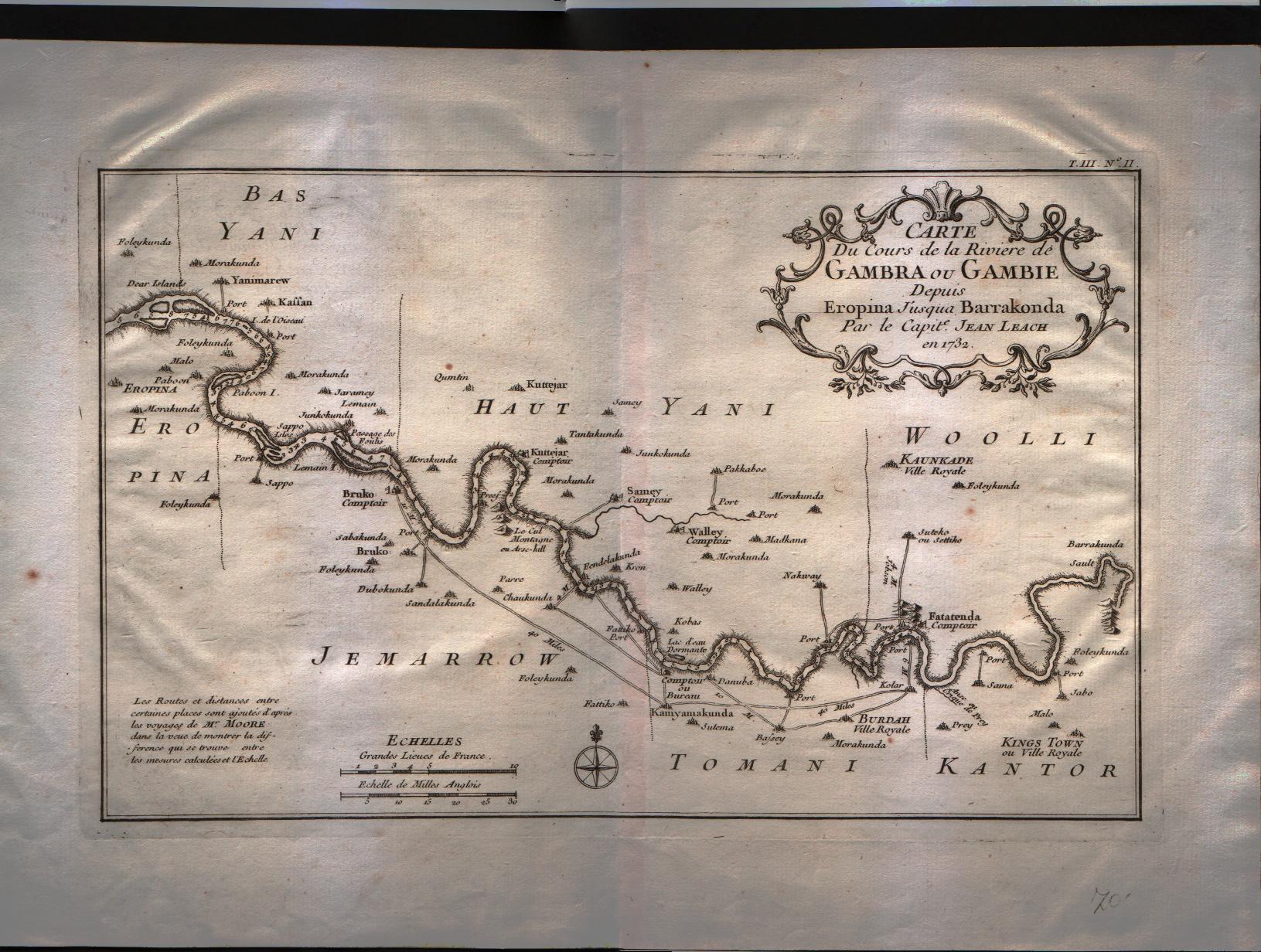
Map title
Carte du cours de la riviere de Gambra ou Gambie depuis Eropina u'j'usqua Barrakonda.
Author
Bellin
Location shown in map
Gambie river.
Edition date
1750
Edition place
Paris
Editor
--
Atlas
Historie General des Voyages -- Prevost
Price
Please ask: info@thetreasuremaps.com
State
[mint/EXCELLENT/very good/good/fair/mediocre/poor]
Color
Black/white
Verso
Blank
Size
Plate: cm (33 x 20.3) inches (12.99 x 7.99) Paper: cm (40.6 x 27.9) inches (15.98 x 10.98)
Technique
Copper engraving
Note
No particular notes for this maps
Reference
--
Wiki
Here for more info
In stock
Available
Info
info@thetreasuremaps.com
Code
#0325
×
![Carte du cours de la riviere de Gambra ou Gambie depuis Eropina u'j'usqua Barrakonda. by Bellin, Gambie river., 1750]()
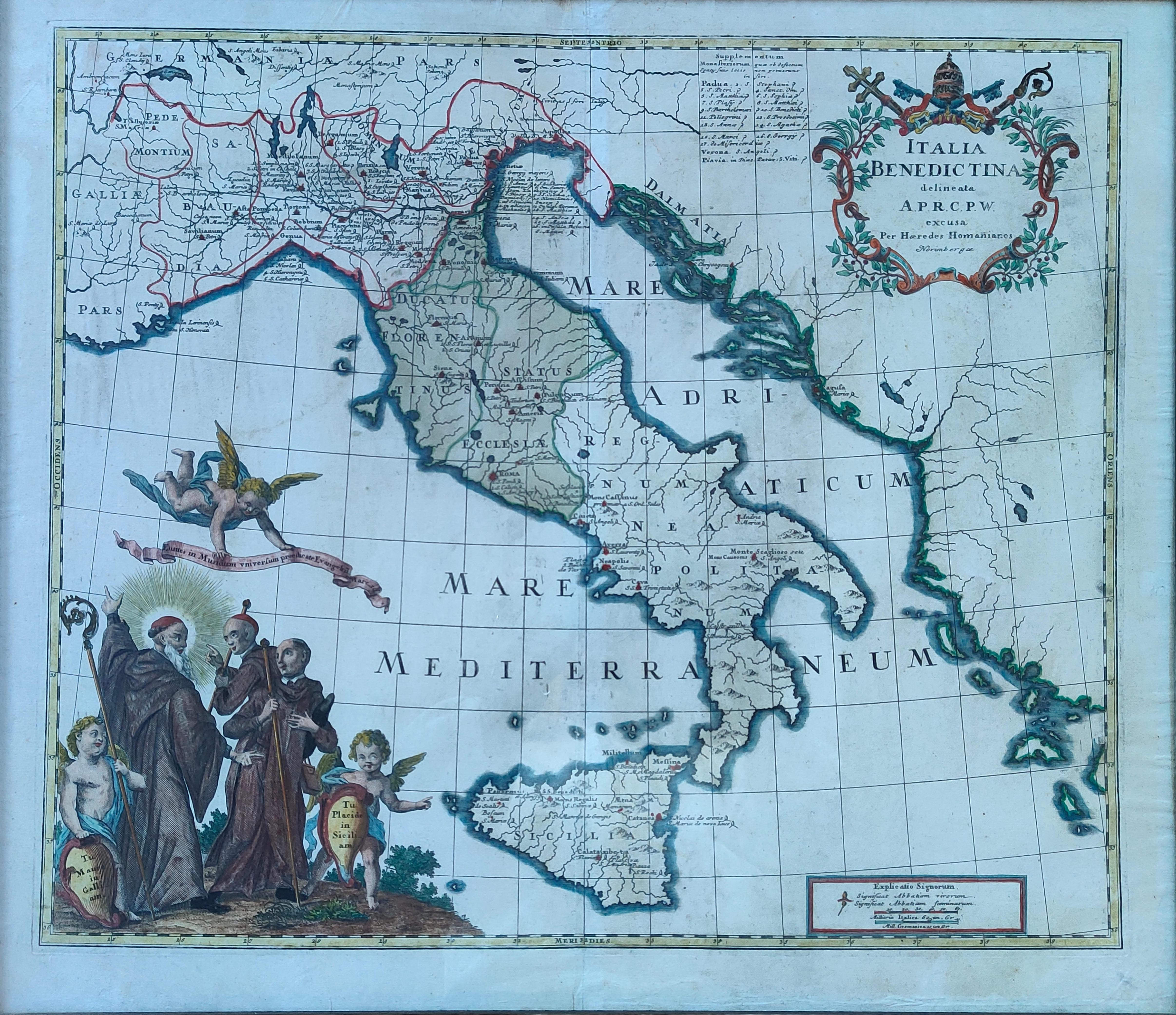
Map title
Italia Benedictina
Author
Homann
Location shown in map
Italy
Edition date
Circa 1750
Edition place
Nurimberg
Editor
Atlas
Price
500 Euro
State
[mint/EXCELLENT/very good/good/fair/mediocre/poor]
Color
Old colors
Verso
Blank
Size
Plate: cm (55 x 47) inches (21.65 x 18.5) Paper: cm (60 x 52) inches (23.62 x 20.47)
Technique
Copper engraving
Note
Reference
R.Borri L'Italia nelle antiche carte pag.221
Wiki
Here for more info
In stock
Available
Info
info@thetreasuremaps.com
Code
#1265
×
![Italia Benedictina by Homann, Italy, Circa 1750]()
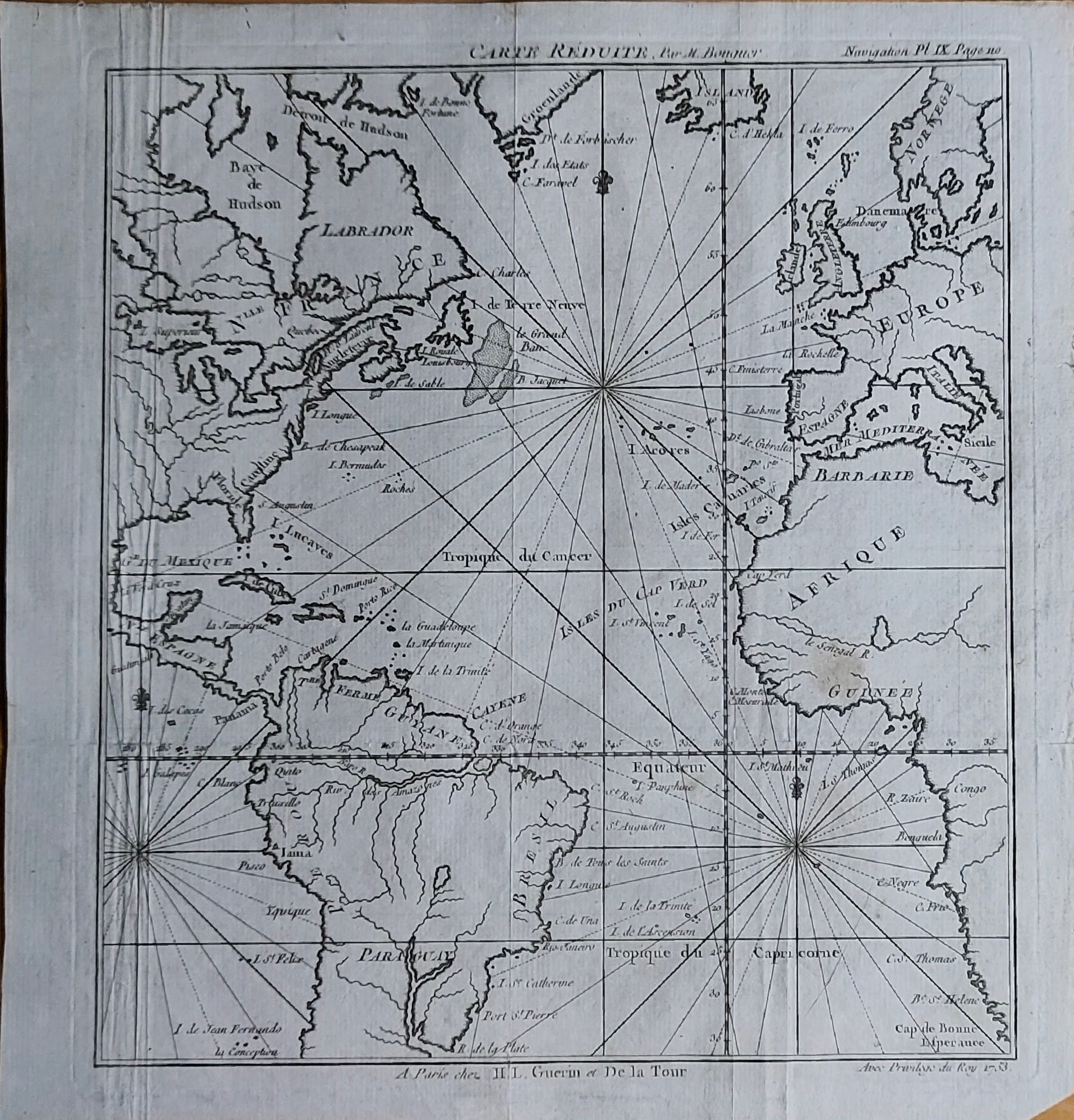
Map title
Carte reduite
Author
Bouguer
Location shown in map
Atlantic
Edition date
1753
Edition place
Paris
Editor
Atlas
Nouveau traité de navigation, contenant la théorie et la pratique du pilotage
Price
150 Euro
State
[mint/EXCELLENT/very good/good/fair/mediocre/poor]
Color
Black/white
Verso
Blank
Size
Plate: cm (21 x 23) inches (8.27 x 9.06) Paper: cm (24 x 26) inches (9.45 x 10.24)
Technique
Copper engraving
Note
Reference
Ex ipso Atlante
Wiki
Here for more info
In stock
Available
Info
info@thetreasuremaps.com
Code
#1356
×
![Carte reduite by Bouguer, Atlantic, 1753]()
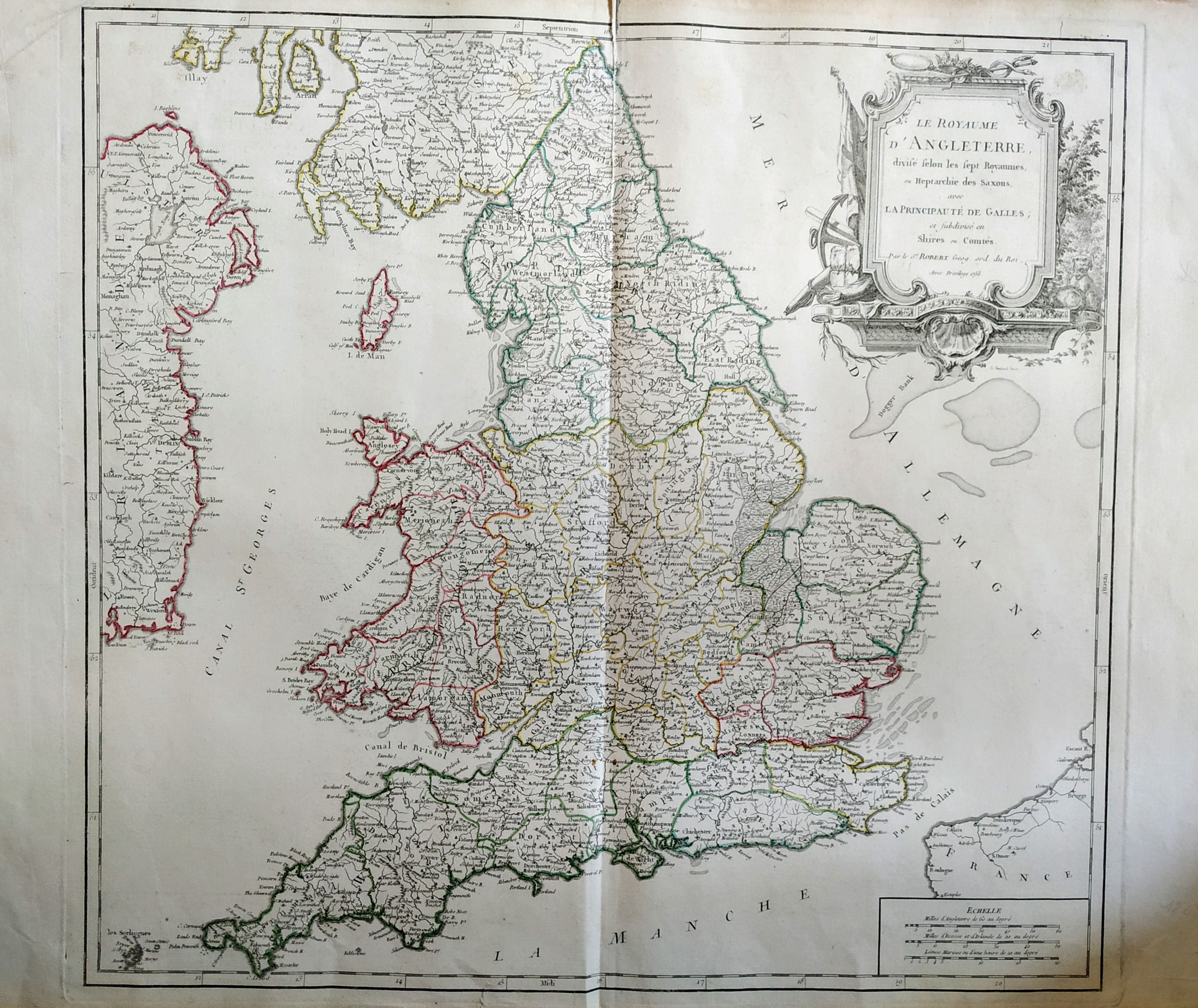
Map title
Le royaume d'Angleterre
Author
Robert de Vaugondy
Location shown in map
British Isles
Edition date
1753
Edition place
Paris
Editor
Delamarche
Atlas
Atlas Universel
Price
200 Euro
State
[mint/excellent/VERY GOOD/good/fair/mediocre/poor]
Color
Old color
Verso
Blank
Size
Plate: cm (66 x 51) inches (25.98 x 20.08) Paper: cm (53 x 49) inches (20.87 x 19.29)
Technique
Copper engraving
Note
No particular notes for this maps.
Reference
--
Wiki
Here for more info
In stock
Available
Info
info@thetreasuremaps.com
Code
#0759
×
![Le royaume d'Angleterre by Robert de Vaugondy, British Isles, 1753]()
Map title
Regiones Italiae
Author
Unknown
Location shown in map
Italy
Edition date
1754
Edition place
Paris
Editor
--
Atlas
Abrege de l'Histoire de Polybe
Price
50 Euro
State
[MINT/excellent/very good/good/fair/mediocre/poor]
Color
Black/white
Verso
Blank
Size
Plate: cm (30.5 x 20.3) inches (12.01 x 7.99) Paper: cm (39.4 x 25.4) inches (15.51 x 10)
Technique
Copper engraving
Note
Reference
--
Wiki
Here for more info
In stock
Available
Info
info@thetreasuremaps.com
Code
#0152
×
![Regiones Italiae by Unknown, Italy, 1754]()
Map title
Sicilia Antiqua
Author
Unknown
Location shown in map
Sicily
Edition date
1754
Edition place
Paris
Editor
--
Atlas
Abrege de l'Histoire de Polybe
Price
Please ask: info@thetreasuremaps.com
State
[MINT/excellent/very good/good/fair/mediocre/poor]
Color
Black/white
Verso
Blank
Size
Plate: cm (30.5 x 22.9) inches (12.01 x 9.02) Paper: cm (39.4 x 25.4) inches (15.51 x 10)
Technique
Copper engraving
Note
No particular notes for this maps
Reference
--
Wiki
Here for more info
In stock
Sold
Info
info@thetreasuremaps.com
Code
#0153
×
![Sicilia Antiqua by Unknown, Sicily, 1754]()
Map title
Les Isles Britanniques qui comprennent les Royaumes d'Angleterre, d'Ecosse et d'Irlande.
Author
Robert de Vaugondy
Location shown in map
British Isles
Edition date
1754
Edition place
Paris
Editor
Atlas
Atlas Universel
Price
200 Euro
State
[mint/EXCELLENT/very good/good/fair/mediocre/poor]
Color
Old colors
Verso
Blank
Size
Plate: cm (58 x 48) inches (22.83 x 18.9) Paper: cm (73 x 55) inches (28.74 x 21.65)
Technique
Copper engraving
Note
Reference
Wiki
Here for more info
In stock
Available
Info
info@thetreasuremaps.com
Code
#1072
×
![Les Isles Britanniques qui comprennent les Royaumes d'Angleterre, d'Ecosse et d'Irlande. by Robert de Vaugondy, British Isles, 1754]()
Map title
America septentrionalis
Author
Homann
Location shown in map
USA
Edition date
1756
Edition place
Nuremberg
Editor
Atlas
Price
800 Euro
State
[mint/EXCELLENT/very good/good/fair/mediocre/poor]
Color
Old colors
Verso
Blank
Size
Plate: cm (55 x 42) inches (21.65 x 16.54) Paper: cm (62 x 52) inches (24.41 x 20.47)
Technique
Copper engraving
Note
United States of America shortly before the revolution, still an English colony
Reference
Wiki
Here for more info
In stock
Available
Info
info@thetreasuremaps.com
Code
#1331
×
![America septentrionalis by Homann, USA, 1756]()
Map title
Plan de Jedo
Author
Bellin
Location shown in map
Japan
Edition date
1757
Edition place
Paris
Editor
--
Atlas
Historie General des Voyages -- Prevost
Price
Please ask: info@thetreasuremaps.com
State
[mint/EXCELLENT/very good/good/fair/mediocre/poor]
Color
Black/white
Verso
Blank
Size
Plate: cm (26.7 x 25.4) inches (10.51 x 10) Paper: cm (24.1 x 24.1) inches (9.49 x 9.49)
Technique
Copper engraving
Note
Map of Tokyo
Reference
--
Wiki
Here for more info
In stock
Sold
Info
info@thetreasuremaps.com
Code
#0375
×
![Plan de Jedo by Bellin, Japan, 1757]()
Map title
Carte de la nouvelle Angleterre
Author
Bellin
Location shown in map
New England
Edition date
1757
Edition place
Paris
Editor
Prevost
Atlas
Historie General des Voyages -- Prevost
Price
300 Euro
State
[mint/EXCELLENT/very good/good/fair/mediocre/poor]
Color
Black/white
Verso
Blank
Size
Plate: cm (29 x 20) inches (11.42 x 7.87) Paper: cm (37 x 25) inches (14.57 x 9.84)
Technique
Copper engraving
Note
The New England colonies are named except Vermont which is still the unnamed disputed territory between New Hampshire and New York. The area covered as a whole extends from Penobscot Bay south to Chesapeake Bay and west to Lake Erie. The map illustrates provinces, towns, forts, rivers, Native American lands and relief.
Reference
--
Wiki
Here for more info
In stock
Available
Info
info@thetreasuremaps.com
Code
#0762
×
![Carte de la nouvelle Angleterre by Bellin, New England, 1757]()
Map title
La ville de Cayenne
Author
Bellin
Location shown in map
Cayenna
Edition date
1757
Edition place
Paris
Editor
--
Atlas
Historie General des Voyages -- Prevost
Price
Please ask: info@thetreasuremaps.com
State
[mint/EXCELLENT/very good/good/fair/mediocre/poor]
Color
Black/white
Verso
Blank
Size
Plate: cm (29.2 x 24.1) inches (11.5 x 9.49) Paper: cm (26.7 x 22.9) inches (10.51 x 9.02)
Technique
Copper engraving
Note
No particular notes for this maps
Reference
--
Wiki
Here for more info
In stock
Sold
Info
info@thetreasuremaps.com
Code
#0022
×
![La ville de Cayenne by Bellin, Cayenna, 1757]()
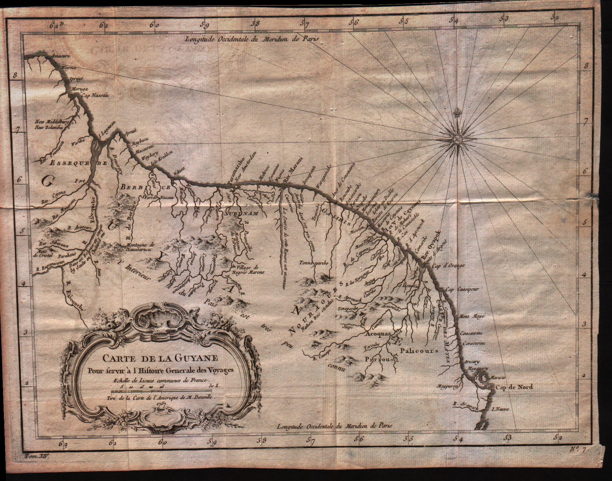
Map title
Carte de la Guyane
Author
Bellin
Location shown in map
Guyane
Edition date
1757
Edition place
Paris
Editor
--
Atlas
Historie General des Voyages -- Prevost
Price
Please ask: info@thetreasuremaps.com
State
[mint/EXCELLENT/very good/good/fair/mediocre/poor]
Color
Black/white
Verso
Blank
Size
Plate: cm (30.5 x 22.9) inches (12.01 x 9.02) Paper: cm (33 x 25.4) inches (12.99 x 10)
Technique
Copper engraving
Note
No particular notes for this maps
Reference
--
Wiki
Here for more info
In stock
Available
Info
info@thetreasuremaps.com
Code
#0021
×
![Carte de la Guyane by Bellin, Guyane, 1757]()
Map title
Plan de la Ville de Peking
Author
Bellin
Location shown in map
Pekin
Edition date
1757
Edition place
Paris
Editor
--
Atlas
Historie General des Voyages -- Prevost
Price
Please ask: info@thetreasuremaps.com
State
[mint/EXCELLENT/very good/good/fair/mediocre/poor]
Color
Black/white
Verso
Blank
Size
Plate: cm (15.2 x 21.6) inches (5.98 x 8.5) Paper: cm (16.5 x 22.9) inches (6.5 x 9.02)
Technique
Copper engraving
Note
No particular notes for this maps
Reference
--
Wiki
Here for more info
In stock
Sold
Info
info@thetreasuremaps.com
Code
#0396
×
![Plan de la Ville de Peking by Bellin, Pekin, 1757]()