1800-1899
Map title
Mappe-Monde
Author
Delamarche
Location shown in map
World
Edition date
1804
Edition place
Paris
Editor
Delamarche
Atlas
Atlas Portatif de Vaugondy
Price
150 Euro
State
[MINT/excellent/very good/good/fair/mediocre/poor]
Color
Old color
Verso
Blank
Size
Plate: cm (38 x 24) inches (14.96 x 9.45) Paper: cm (44 x 30) inches (17.32 x 11.81)
Technique
Copper engraving
Note
Reference
--
Wiki
Here for more info
In stock
Available
Info
info@thetreasuremaps.com
Code
#0753
×
![Mappe-Monde by Delamarche, World, 1804]()
Map title
L'Italia
Author
Zatta
Location shown in map
Italy
Edition date
1804
Edition place
Venice
Editor
Atlas
Nuovo atlante
Price
150 Euro
State
[mint/excellent/VERY GOOD/good/fair/mediocre/poor]
Color
Old colors
Verso
Blank
Size
Plate: cm (16 x 16) inches (6.3 x 6.3) Paper: cm (18 x 28) inches (7.09 x 11.02)
Technique
Copper engraving
Note
Reference
Wiki
Here for more info
In stock
Available
Info
info@thetreasuremaps.com
Code
#0912
×
![L'Italia by Zatta, Italy, 1804]()
Map title
Etats de la seigneurie et republique de Gènes.
Author
Remondini
Location shown in map
Liguria
Edition date
1804
Edition place
Venice
Editor
Atlas
Price
600 Euro
State
[mint/EXCELLENT/very good/good/fair/mediocre/poor]
Color
Old colors
Verso
Blank
Size
Plate: cm (68 x 49) inches (26.77 x 19.29) Paper: cm (72 x 52) inches (28.35 x 20.47)
Technique
Copper engraving
Note
Never inserted in atlas
Reference
L.Tricerri, Catalog of Maps of Liguria R_138
Wiki
Here for more info
In stock
Available
Info
info@thetreasuremaps.com
Code
#1339
×
![Etats de la seigneurie et republique de Gènes.
by Remondini, Liguria, 1804]()
Map title
Italie
Author
Arrowsmith
Location shown in map
Italy
Edition date
Circa 1806
Edition place
Editor
--
Atlas
Price
75 Euro
State
[mint/EXCELLENT/very good/good/fair/mediocre/poor]
Color
Black/white
Verso
Blank
Size
Plate: cm (25 x 21) inches (9.84 x 8.27) Paper: cm (34 x 26) inches (13.39 x 10.24)
Technique
Copper engraving
Note
Reference
Wiki
Here for more info
In stock
Available
Info
info@thetreasuremaps.com
Code
#0937
×
![Italie by Arrowsmith, Italy, Circa 1806]()

Map title
Asia from the latest authorities
Author
Location shown in map
Asia
Edition date
1806
Edition place
London
Editor
Bungay
Atlas
Price
50 Euro
State
[mint/EXCELLENT/very good/good/fair/mediocre/poor]
Color
Black/white
Verso
Blank
Size
Plate: cm (23 x 19) inches (9.06 x 7.48) Paper: cm (25 x 21) inches (9.84 x 8.27)
Technique
Copper engraving
Note
Reference
Wiki
Here for more info
In stock
Available
Info
info@thetreasuremaps.com
Code
#1298
×
![Asia from the latest authorities by , Asia, 1806]()
Map title
Possessioni della Spagna nell'america Settentrionale e Carta Generale del Messico
Author
Unknown
Location shown in map
South USA and Mexico
Edition date
1807
Edition place
Milan
Editor
--
Atlas
Barbiellini Atlante delle geografica antica e moderna
Price
125 Euro
State
[mint/EXCELLENT/very good/good/fair/mediocre/poor]
Color
Old outlined
Verso
Blank
Size
Plate: cm (24.8 x 19.7) inches (9.76 x 7.76) Paper: cm (27.9 x 22.9) inches (10.98 x 9.02)
Technique
Copper engraving
Note
Map of the Texas, Mexico, Upper California, Louisiana Territory and Florida. The cartography is certainly pre-1810, naming East and West Florida, showing a pre-Louisiana Purchase Louisiana and very early placenames in the Southwest, most notably Pimeria, Bagiopas, and Quivira, names which would disappear from the map within a few years. Another noteworthy feature is the listing of the Missions in Upper California, which do not generally appear in atlas maps of the period. Nice detail in Texas, including the appearance of the actual name Texas, another unusual early feature. A number of forts and Indian Tribes located. An interesting early map of the region.
Reference
--
Wiki
Here for more info
In stock
Available
Info
info@thetreasuremaps.com
Code
#0084
×
![Possessioni della Spagna nell'america Settentrionale e Carta Generale del Messico by Unknown, South USA and Mexico , 1807]()
Map title
Italien
Author
Location shown in map
Italy
Edition date
1808
Edition place
Weimar
Editor
Atlas
Price
150 Euro
State
[mint/EXCELLENT/very good/good/fair/mediocre/poor]
Color
Old colors
Verso
Blank
Size
Plate: cm (33 x 44) inches (12.99 x 17.32) Paper: cm (31 x 42) inches (12.2 x 16.54)
Technique
Copper engraving
Note
Reference
Wiki
Here for more info
In stock
Available
Info
info@thetreasuremaps.com
Code
#0916
×
![Italien by , Italy, 1808]()
Map title
Kingdom of Italy, Etruria, Naples
Author
Location shown in map
Italy
Edition date
1808
Edition place
London
Editor
Atlas
Price
150 Euro
State
[mint/EXCELLENT/very good/good/fair/mediocre/poor]
Color
Old colors
Verso
Blank
Size
Plate: cm (51 x 43) inches (20.08 x 16.93) Paper: cm (39 x 34) inches (15.35 x 13.39)
Technique
Copper engraving
Note
Reference
Wiki
Here for more info
In stock
Available
Info
info@thetreasuremaps.com
Code
#0917
×
![Kingdom of Italy, Etruria, Naples by , Italy, 1808]()
Map title
Charte von Asien
Author
Walch
Location shown in map
Asia
Edition date
1808
Edition place
Augsburg
Editor
Atlas
Price
200 Euro
State
[mint/excellent/VERY GOOD/good/fair/mediocre/poor]
Color
Old colors
Verso
Blank
Size
Plate: cm (43.2 x 59) inches (17.01 x 23.23) Paper: cm (62 x 51) inches (24.41 x 20.08)
Technique
Copper engraving
Note
Reference
--
Wiki
Here for more info
In stock
Available
Info
info@thetreasuremaps.com
Code
#1149
×
![Charte von Asien by Walch, Asia, 1808]()
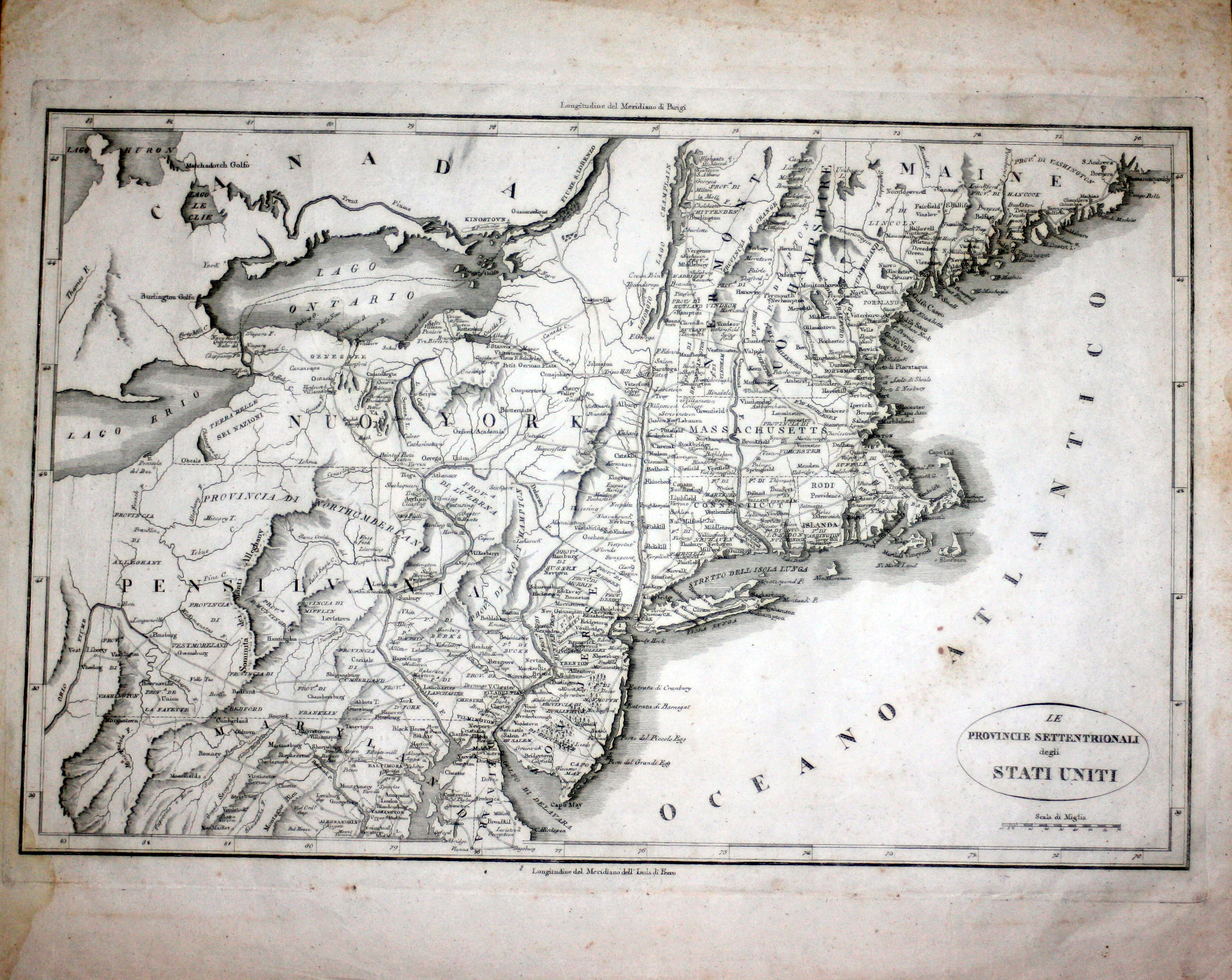
Map title
Le provincie settentrionali degli Stati Uniti
Author
Botta
Location shown in map
North East
Edition date
1809
Edition place
Firenze
Editor
Marchini
Atlas
Storia Della Guerra Dell' Independenza Degli Stati Uniti d'America
Price
150 Euro
State
[mint/EXCELLENT/very good/good/fair/mediocre/poor]
Color
Black/white
Verso
White
Size
Plate: cm (48.3 x 31.8) inches (19.02 x 12.52) Paper: cm (50.8 x 41.9) inches (20 x 16.5)
Technique
Copper engraving
Note
No particular notes for this maps.
Reference
--
Wiki
Here for more info
In stock
Available
Info
info@thetreasuremaps.com
Code
#0539
×
![Le provincie settentrionali degli Stati Uniti by Botta, North East, 1809]()
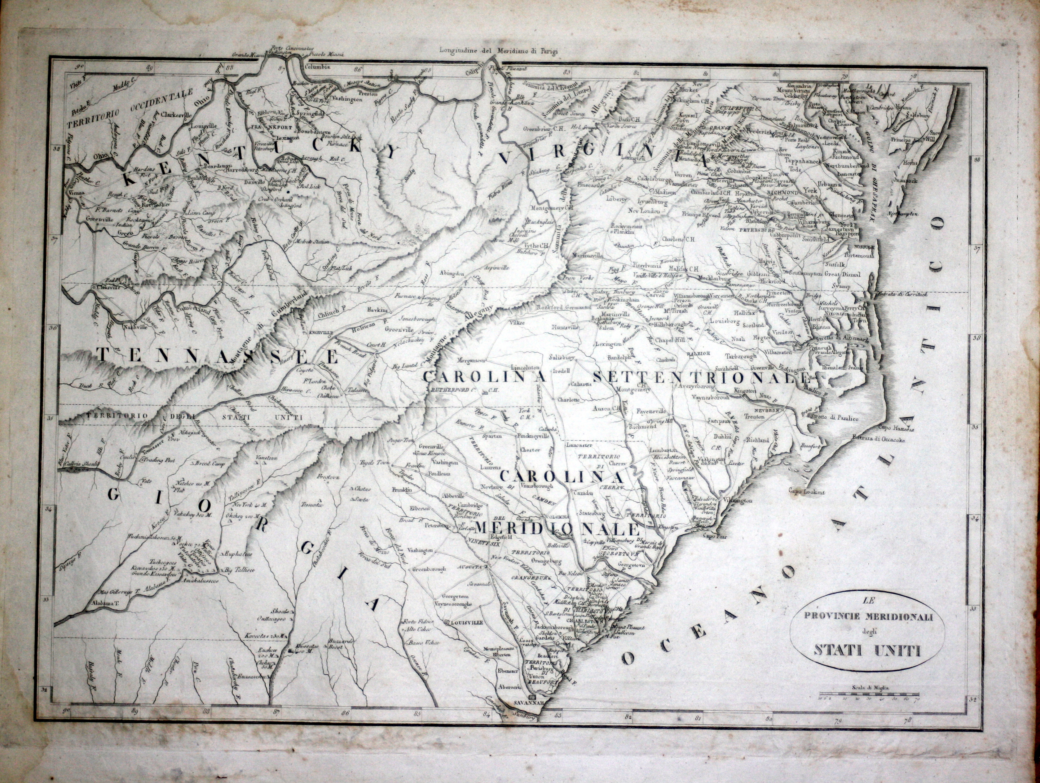
Map title
Le provincie meridionali degli Stati Uniti
Author
Botta
Location shown in map
South East coast
Edition date
1809
Edition place
Firenze
Editor
Marchini
Atlas
Storia Della Guerra Dell' Independenza Degli Stati Uniti d'America
Price
150 Euro
State
[mint/EXCELLENT/very good/good/fair/mediocre/poor]
Color
Black/white
Verso
White
Size
Plate: cm (48.3 x 31.8) inches (19.02 x 12.52) Paper: cm (50.8 x 41.9) inches (20 x 16.5)
Technique
Copper engraving
Note
No particular notes for this maps.
Reference
--
Wiki
Here for more info
In stock
Available
Info
info@thetreasuremaps.com
Code
#0540
×
![Le provincie meridionali degli Stati Uniti by Botta, South East coast, 1809]()
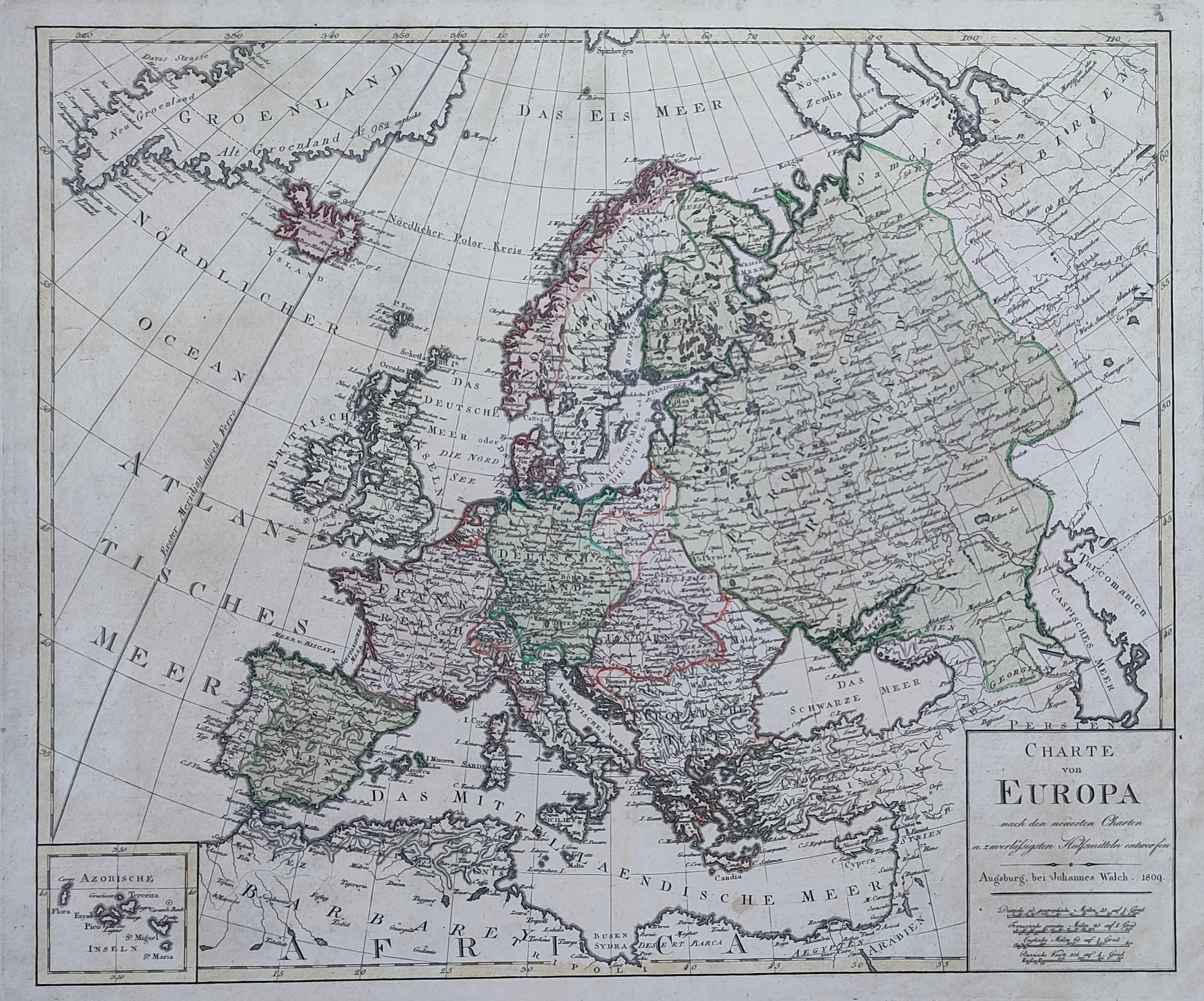
Map title
Charte von Europa
Author
Walch
Location shown in map
All Europe
Edition date
1809
Edition place
Augsburg
Editor
Atlas
Price
175 Euro
State
[mint/EXCELLENT/very good/good/fair/mediocre/poor]
Color
Old colors
Verso
Blank
Size
Plate: cm (56 x 47) inches (22.05 x 18.5) Paper: cm (71 x 59) inches (27.95 x 23.23)
Technique
Copper engraving
Note
Reference
Wiki
Here for more info
In stock
Available
Info
info@thetreasuremaps.com
Code
#1236
×
![Charte von Europa by Walch, All Europe, 1809]()
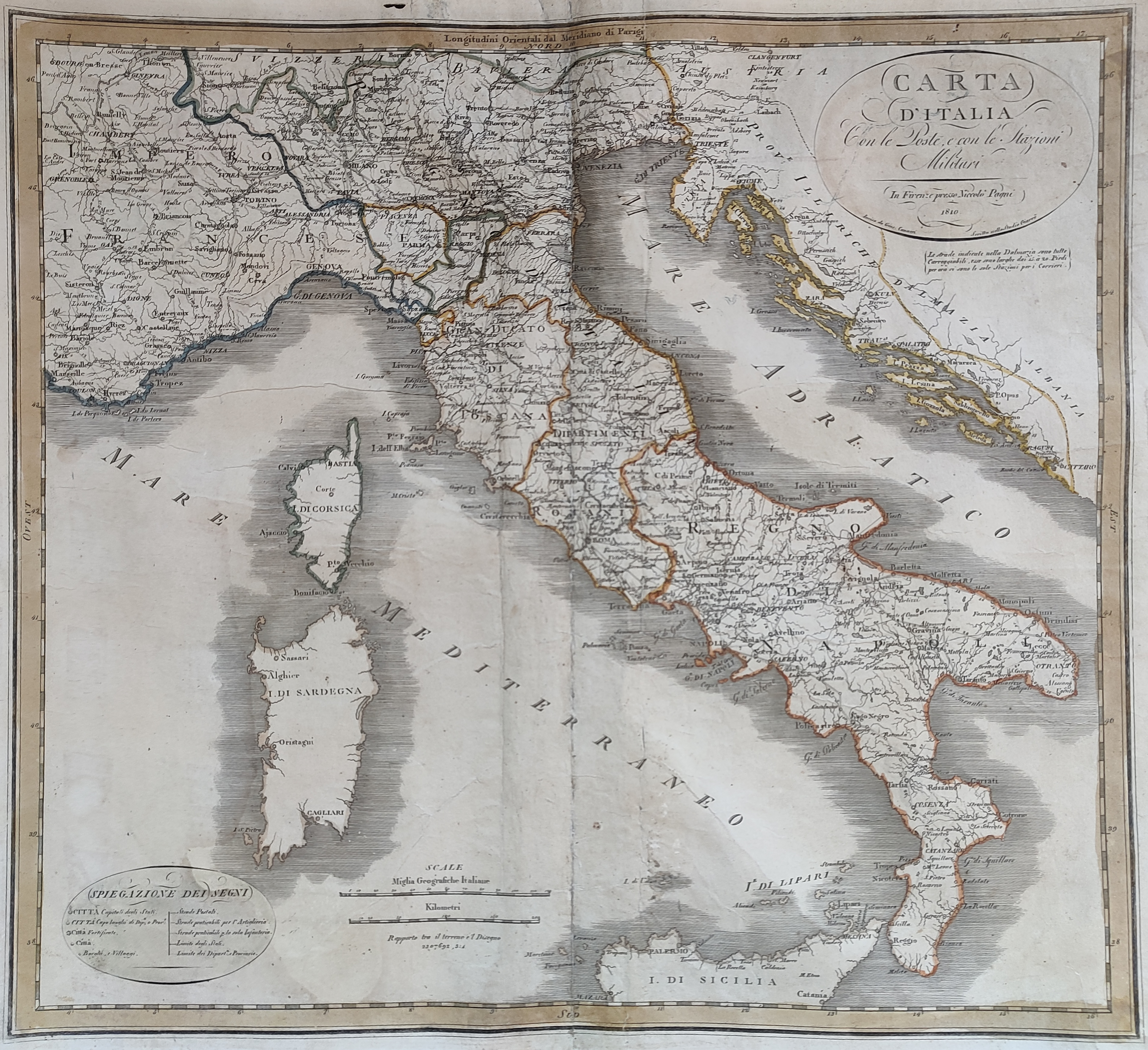
Map title
Carta d'Italia con le poste
Author
Location shown in map
Italy
Edition date
1810
Edition place
Florence
Editor
Pagni
Atlas
Price
150 Euro
State
[mint/excellent/VERY GOOD/good/fair/mediocre/poor]
Color
Old colors
Verso
Blank
Size
Plate: cm (54 x 52) inches (21.26 x 20.47) Paper: cm (48 x 45) inches (18.9 x 17.72)
Technique
Copper engraving
Note
Reference
Wiki
Here for more info
In stock
Available
Info
info@thetreasuremaps.com
Code
#0915
×
![Carta d'Italia con le poste by , Italy, 1810]()
Map title
Carte des Etats-Unis
Author
Delamarche
Location shown in map
USA
Edition date
1811
Edition place
Paris
Editor
--
Atlas
Atlas Portatif de Vaugondy
Price
125 Euro
State
[mint/excellent/VERY GOOD/good/fair/mediocre/poor]
Color
Old outlined
Verso
Blank
Size
Plate: cm (27 x 29) inches (10.63 x 11.42) Paper: cm (48 x 31) inches (18.9 x 12.2)
Technique
Copper engraving
Note
Reference
--
Wiki
Here for more info
In stock
Available
Info
info@thetreasuremaps.com
Code
#0749
×
![Carte des Etats-Unis by Delamarche, USA, 1811]()
Map title
Italy
Author
Wallis
Location shown in map
Italy
Edition date
Circa 1811
Edition place
London
Editor
S.A.Oddy
Atlas
Price
100 Euro
State
[mint/EXCELLENT/very good/good/fair/mediocre/poor]
Color
Old colors
Verso
Blank
Size
Plate: cm (27 x 29) inches (10.63 x 11.42) Paper: cm (27 x 36) inches (10.63 x 14.17)
Technique
Copper engraving
Note
Reference
Wiki
Here for more info
In stock
Available
Info
info@thetreasuremaps.com
Code
#1112
Italy
Author
Wallis
Location shown in map
Italy
Edition date
Circa 1811
Edition place
London
Editor
S.A.Oddy
Atlas
Price
100 Euro
State
[mint/EXCELLENT/very good/good/fair/mediocre/poor]
Color
Old colors
Verso
Blank
Size
Plate: cm (27 x 29) inches (10.63 x 11.42) Paper: cm (27 x 36) inches (10.63 x 14.17)
Technique
Copper engraving
Note
Reference
Wiki
Here for more info
In stock
Available
Info
info@thetreasuremaps.com
Code
#1112
×
![Italy by Wallis, Italy, Circa 1811]()
Map title
Nouvelle Espagne
Author
Delamarche
Location shown in map
Mexico
Edition date
1812
Edition place
Paris
Editor
--
Atlas
Atlas Portatif de Vaugondy
Price
125 Euro
State
[mint/excellent/VERY GOOD/good/fair/mediocre/poor]
Color
Old outlined
Verso
Blank
Size
Plate: cm (36 x 24) inches (14.17 x 9.45) Paper: cm (48 x 31) inches (18.9 x 12.2)
Technique
Copper engraving
Note
Reference
--
Wiki
Here for more info
In stock
Available
Info
info@thetreasuremaps.com
Code
#0750
×
![Nouvelle Espagne by Delamarche, Mexico, 1812]()
Map title
Partie septentrionale du Perou
Author
Bellin
Location shown in map
--
Edition date
1813
Edition place
Paris
Editor
--
Atlas
Nouvel Atlas Portatif
Price
Please ask: info@thetreasuremaps.com
State
[mint/excellent/very good/GOOD/fair/mediocre/poor]
Color
Old outlined
Verso
Blank
Size
Plate: cm (19 x 16.5) inches (7.48 x 6.5) Paper: cm (22.9 x 20.3) inches (9.02 x 7.99)
Technique
--
Note
No particular notes for this maps
Reference
--
Wiki
Here for more info
In stock
Available
Info
info@thetreasuremaps.com
Code
#0051
×
![Partie septentrionale du Perou by Bellin, --, 1813]()
Map title
Mappe-monde ou le globe terrestre
Author
Herrison
Location shown in map
World
Edition date
1816
Edition place
Paris
Editor
Basset
Atlas
Price
600 Euro
State
[mint/EXCELLENT/very good/good/fair/mediocre/poor]
Color
Old colors
Verso
Size
Plate: cm (100 x 60) inches (39.37 x 23.62) Paper: cm (100 x 60) inches (39.37 x 23.62)
Technique
Copper engraving
Note
framed
Reference
Wiki
Here for more info
In stock
Available
Info
info@thetreasuremaps.com
Code
#1225
×
![Mappe-monde ou le globe terrestre by Herrison, World, 1816]()
Map title
Italy
Author
Location shown in map
Italy
Edition date
1817
Edition place
Leeds
Editor
Atlas
Price
75 Euro
State
[mint/EXCELLENT/very good/good/fair/mediocre/poor]
Color
Black/white
Verso
Blank
Size
Plate: cm (19 x 24) inches (7.48 x 9.45) Paper: cm (21 x 27) inches (8.27 x 10.63)
Technique
Copper engraving
Note
Reference
Wiki
Here for more info
In stock
Available
Info
info@thetreasuremaps.com
Code
#1062
Italy
Author
Location shown in map
Italy
Edition date
1817
Edition place
Leeds
Editor
Atlas
Price
75 Euro
State
[mint/EXCELLENT/very good/good/fair/mediocre/poor]
Color
Black/white
Verso
Blank
Size
Plate: cm (19 x 24) inches (7.48 x 9.45) Paper: cm (21 x 27) inches (8.27 x 10.63)
Technique
Copper engraving
Note
Reference
Wiki
Here for more info
In stock
Available
Info
info@thetreasuremaps.com
Code
#1062
×
![Italy by , Italy, 1817]()

Map title
Dominj Inglesi in America
Author
Location shown in map
--
Edition date
1820
Edition place
Milan
Editor
--
Atlas
Atlante Nuovo di Batelli & Fanfani
Price
Please ask: info@thetreasuremaps.com
State
[mint/EXCELLENT/very good/good/fair/mediocre/poor]
Color
Black/white
Verso
Blank
Size
Plate: cm (24.1 x 20.3) inches (9.49 x 7.99) Paper: cm (45.7 x 27.9) inches (17.99 x 10.98)
Technique
Copper engraving
Note
Very uncommon Copper engraving map with details in Canada and Alaska. The Monte Stoney o delle Pietre (Stoney Mountains) dominate the west where a hypothetical connection is shown between the Missouri and Columbia rivers. The longitude is measured from the island of Ferro.
Reference
--
Wiki
Here for more info
In stock
Sold
Info
info@thetreasuremaps.com
Code
#0382
×
![Dominj Inglesi in America by , --, 1820]()