1800-1899

Map title
Carta delle isole Antille
Author
Unknown
Location shown in map
--
Edition date
1820
Edition place
Milan
Editor
--
Atlas
Atlante Nuovo di Batelli & Fanfani
Price
Please ask: info@thetreasuremaps.com
State
[mint/EXCELLENT/very good/good/fair/mediocre/poor]
Color
Old outlined
Verso
Blank
Size
Plate: cm (41.9 x 34.3) inches (16.5 x 13.5) Paper: cm (41.9 x 34.3) inches (16.5 x 13.5)
Technique
--
Note
No particular notes for this maps
Reference
--
Wiki
Here for more info
In stock
Sold
Info
info@thetreasuremaps.com
Code
#0478
×
![Carta delle isole Antille by Unknown, --, 1820]()
Map title
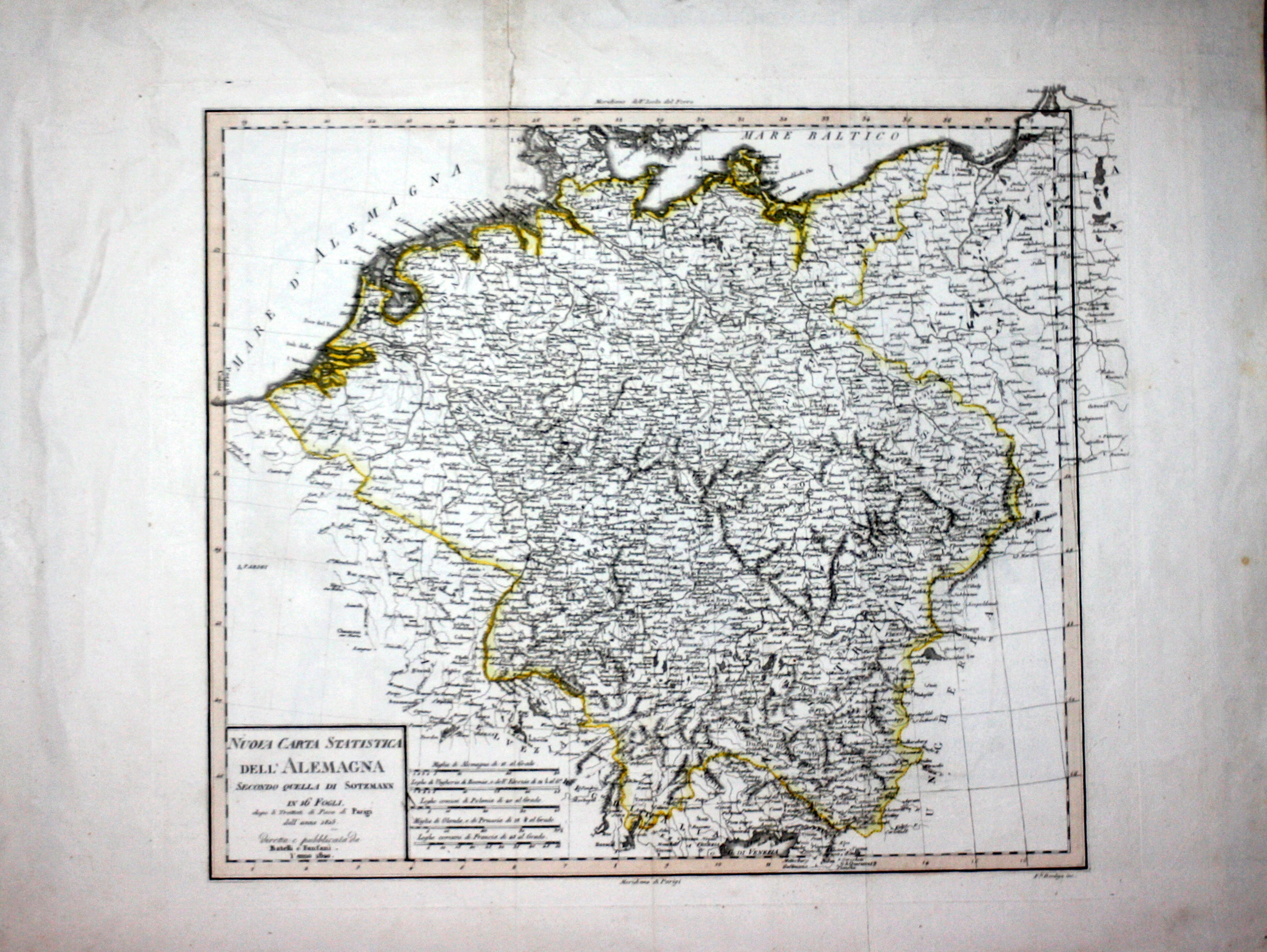
Nuova carta statistica dell'Alemagna
Author
Bordiga
Location shown in map
Germany
Edition date
1820
Edition place
Milan
Editor
Battelli e Fanfani
Atlas
Nuovo atlante di geografia universale
Price
50 Euro
State
[mint/EXCELLENT/very good/good/fair/mediocre/poor]
Color
Old color
Verso
White
Size
Plate: cm (38.1 x 33) inches (15 x 12.99) Paper: cm (58.4 x 45.7) inches (22.99 x 17.99)
Technique
Steel engraving
Note
No particular notes for this maps.
Reference
--
Wiki
Here for more info
In stock
Available
Info
info@thetreasuremaps.com
Code
#0544
×
![Nuova carta statistica dell'Alemagna by Bordiga, Germany, 1820]()
Map title
Carta di S.Domingo giusta quella di Poirson
Author
Unknown
Location shown in map
--
Edition date
1820
Edition place
Milan
Editor
--
Atlas
Atlante Nuovo di Batelli & Fanfani
Price
Please ask: info@thetreasuremaps.com
State
[mint/EXCELLENT/very good/good/fair/mediocre/poor]
Color
Old outlined
Verso
Blank
Size
Plate: cm (40.6 x 33) inches (15.98 x 12.99) Paper: cm (62.2 x 45.7) inches (24.49 x 17.99)
Technique
--
Note
No particular notes for this maps
Reference
--
Wiki
Here for more info
In stock
Sold
Info
info@thetreasuremaps.com
Code
#0479
×
![Carta di S.Domingo giusta quella di Poirson by Unknown, --, 1820]()
Map title
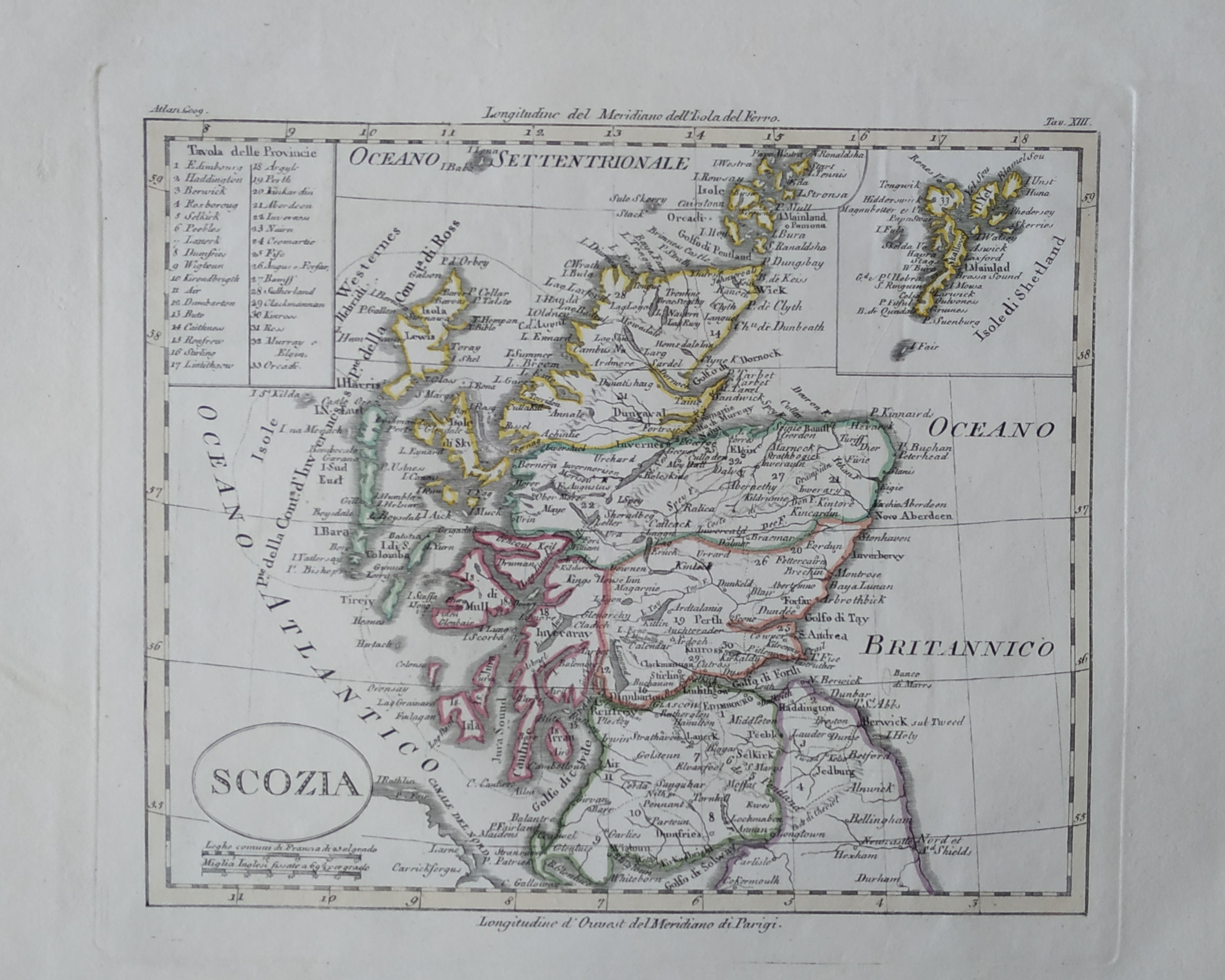
Scozia
Author
Unknown
Location shown in map
Scotland
Edition date
1820
Edition place
Milan
Editor
--
Atlas
Atlante Nuovo di Batelli & Fanfani
Price
125 Euro
State
[mint/EXCELLENT/very good/good/fair/mediocre/poor]
Color
Old outlined
Verso
Blank
Size
Plate: cm (21.6 x 17.8) inches (8.5 x 7.01) Paper: cm (21.6 x 17.8) inches (8.5 x 7.01)
Technique
--
Note
No particular notes for this maps
Reference
--
Wiki
Here for more info
In stock
Sold
Info
info@thetreasuremaps.com
Code
#0491
×
![Scozia by Unknown, Scotland, 1820]()
Map title
Dominj Inglesi in America
Author
Location shown in map
--
Edition date
1820
Edition place
Milan
Editor
--
Atlas
Atlante Nuovo di Batelli & Fanfani
Price
Please ask: info@thetreasuremaps.com
State
[mint/EXCELLENT/very good/good/fair/mediocre/poor]
Color
Black/white
Verso
Blank
Size
Plate: cm (24.1 x 20.3) inches (9.49 x 7.99) Paper: cm (45.7 x 27.9) inches (17.99 x 10.98)
Technique
Copper engraving
Note
Very uncommon Copper engraving map with details in Canada and Alaska. The Monte Stoney o delle Pietre (Stoney Mountains) dominate the west where a hypothetical connection is shown between the Missouri and Columbia rivers. The longitude is measured from the island of Ferro.
Reference
--
Wiki
Here for more info
In stock
Sold
Info
info@thetreasuremaps.com
Code
#0382
×
![Dominj Inglesi in America by , --, 1820]()
Map title
L'America meridionale
Author
Unknown
Location shown in map
South America
Edition date
1820
Edition place
Milan
Editor
--
Atlas
Atlante Nuovo di Batelli & Fanfani
Price
Please ask: info@thetreasuremaps.com
State
[mint/EXCELLENT/very good/good/fair/mediocre/poor]
Color
Old outlined
Verso
Blank
Size
Plate: cm (68.6 x 40.6) inches (27.01 x 15.98) Paper: cm (68.6 x 40.6) inches (27.01 x 15.98)
Technique
--
Note
No particular notes for this maps
Reference
--
Wiki
Here for more info
In stock
Sold
Info
info@thetreasuremaps.com
Code
#0466
×
![L'America meridionale by Unknown, South America, 1820]()
Map title
America meridionale
Author
Unknown
Location shown in map
South America
Edition date
1820
Edition place
Milan
Editor
--
Atlas
??? - Civelli Giuseppe
Price
Please ask: info@thetreasuremaps.com
State
[mint/excellent/VERY GOOD/good/fair/mediocre/poor]
Color
Old outlined
Verso
Blank
Size
Plate: cm (38.1 x 30.5) inches (15 x 12.01) Paper: cm (41.9 x 33) inches (16.5 x 12.99)
Technique
--
Note
No particular notes for this maps
Reference
--
Wiki
Here for more info
In stock
Sold
Info
info@thetreasuremaps.com
Code
#0465
×
![America meridionale by Unknown, South America, 1820]()
Map title
Carta della Gujana francese ed olandese
Author
Unknown
Location shown in map
--
Edition date
1820
Edition place
Milan
Editor
--
Atlas
Atlante Nuovo di Batelli & Fanfani
Price
Please ask: info@thetreasuremaps.com
State
[mint/EXCELLENT/very good/good/fair/mediocre/poor]
Color
Old outlined
Verso
Blank
Size
Plate: cm (40.6 x 33) inches (15.98 x 12.99) Paper: cm (40.6 x 33) inches (15.98 x 12.99)
Technique
--
Note
No particular notes for this maps
Reference
--
Wiki
Here for more info
In stock
Sold
Info
info@thetreasuremaps.com
Code
#0464
×
![Carta della Gujana francese ed olandese by Unknown, --, 1820]()
Map title
Grande oceano ovvero quinta parte del mondo
Author
Location shown in map
--
Edition date
1820
Edition place
Milan
Editor
--
Atlas
Atlante Nuovo di Batelli & Fanfani
Price
Please ask: info@thetreasuremaps.com
State
[mint/EXCELLENT/very good/good/fair/mediocre/poor]
Color
Old outlined
Verso
Blank
Size
Plate: cm (25.4 x 20.3) inches (10 x 7.99) Paper: cm (25.4 x 20.3) inches (10 x 7.99)
Technique
Copper engraving
Note
No particular notes for this maps
Reference
--
Wiki
Here for more info
In stock
Sold
Info
info@thetreasuremaps.com
Code
#0377
×
![Grande oceano ovvero quinta parte del mondo by , --, 1820]()
Map title
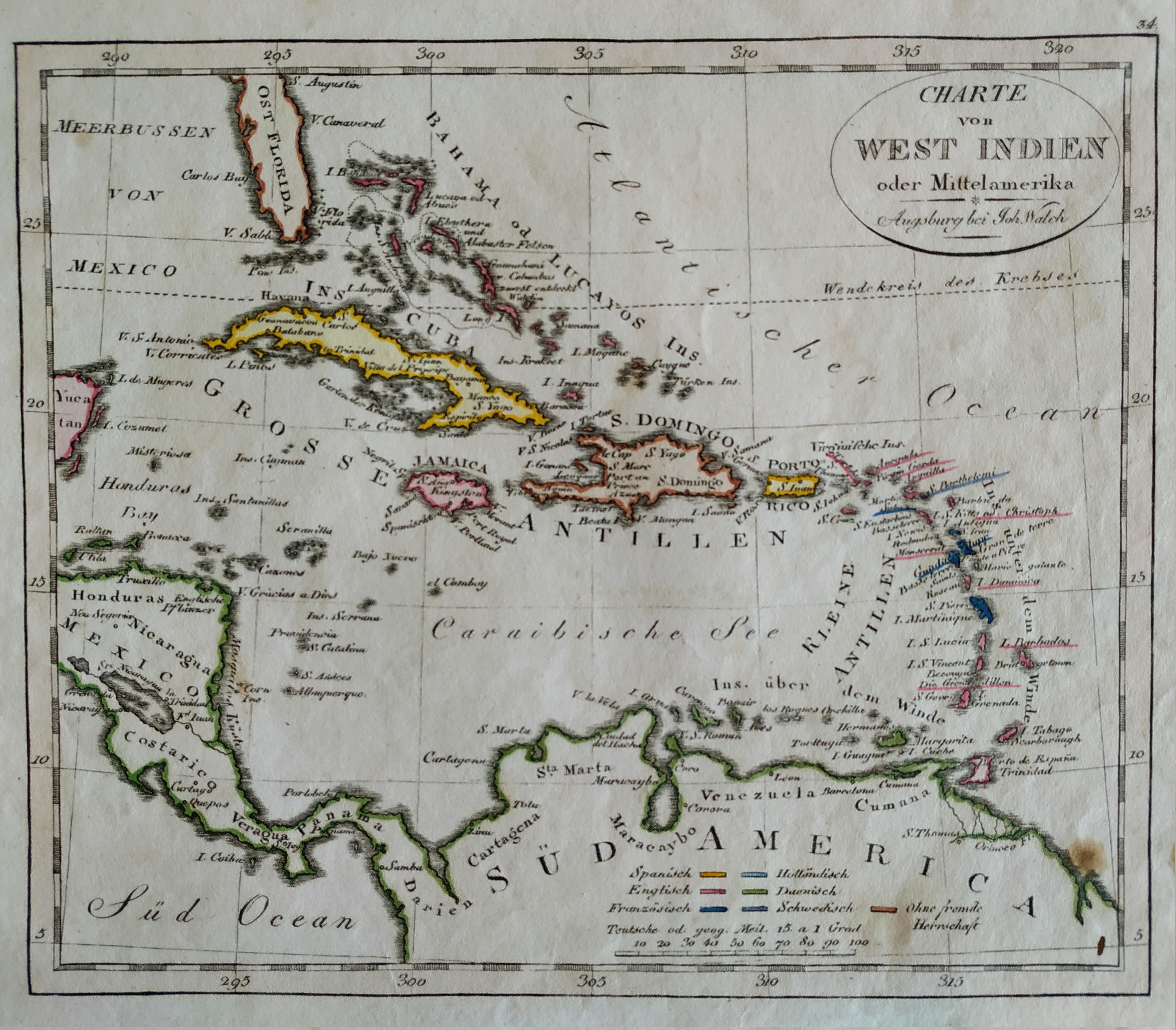
Charte von west Indien
Author
Johann Walch
Location shown in map
West Indies
Edition date
1820
Edition place
Hamburg
Editor
Atlas
Price
Please ask: info@thetreasuremaps.com
State
[mint/EXCELLENT/very good/good/fair/mediocre/poor]
Color
Old colors
Verso
Blank
Size
Plate: cm (21 x 18) inches (8.27 x 7.09) Paper: cm (26 x 22) inches (10.24 x 8.66)
Technique
Steel engraving
Note
No particular notes for this maps
Reference
Wiki
Here for more info
In stock
Available
Info
info@thetreasuremaps.com
Code
#0700
×
![Charte von west Indien by Johann Walch, West Indies, 1820]()
Map title
Asia
Author
Unknown
Location shown in map
Asia
Edition date
1820
Edition place
Milan
Editor
--
Atlas
Atlante Nuovo di Batelli & Fanfani
Price
Please ask: info@thetreasuremaps.com
State
[mint/EXCELLENT/very good/good/fair/mediocre/poor]
Color
Old outlined
Verso
Blank
Size
Plate: cm (22.9 x 17.8) inches (9.02 x 7.01) Paper: cm (45.7 x 27.9) inches (17.99 x 10.98)
Technique
--
Note
No particular notes for this maps
Reference
--
Wiki
Here for more info
In stock
Sold
Info
info@thetreasuremaps.com
Code
#0435
Asia
Author
Unknown
Location shown in map
Asia
Edition date
1820
Edition place
Milan
Editor
--
Atlas
Atlante Nuovo di Batelli & Fanfani
Price
Please ask: info@thetreasuremaps.com
State
[mint/EXCELLENT/very good/good/fair/mediocre/poor]
Color
Old outlined
Verso
Blank
Size
Plate: cm (22.9 x 17.8) inches (9.02 x 7.01) Paper: cm (45.7 x 27.9) inches (17.99 x 10.98)
Technique
--
Note
No particular notes for this maps
Reference
--
Wiki
Here for more info
In stock
Sold
Info
info@thetreasuremaps.com
Code
#0435
×
![Asia by Unknown, Asia, 1820]()
Map title
North America
Author
Unknown
Location shown in map
North America
Edition date
1820
Edition place
London
Editor
--
Atlas
Published by Thomas Kelly
Price
Please ask: info@thetreasuremaps.com
State
[mint/EXCELLENT/very good/good/fair/mediocre/poor]
Color
Uncoloured
Verso
Blank
Size
Plate: cm (19 x 24.1) inches (7.48 x 9.49) Paper: cm (21.6 x 26.7) inches (8.5 x 10.51)
Technique
Copper engraving
Note
Map of North America in early XIX.
Reference
--
Wiki
Here for more info
In stock
Sold
Info
info@thetreasuremaps.com
Code
#0410
North America
Author
Unknown
Location shown in map
North America
Edition date
1820
Edition place
London
Editor
--
Atlas
Published by Thomas Kelly
Price
Please ask: info@thetreasuremaps.com
State
[mint/EXCELLENT/very good/good/fair/mediocre/poor]
Color
Uncoloured
Verso
Blank
Size
Plate: cm (19 x 24.1) inches (7.48 x 9.49) Paper: cm (21.6 x 26.7) inches (8.5 x 10.51)
Technique
Copper engraving
Note
Map of North America in early XIX.
Reference
--
Wiki
Here for more info
In stock
Sold
Info
info@thetreasuremaps.com
Code
#0410
×
![North America by Unknown, North America, 1820]()
Map title
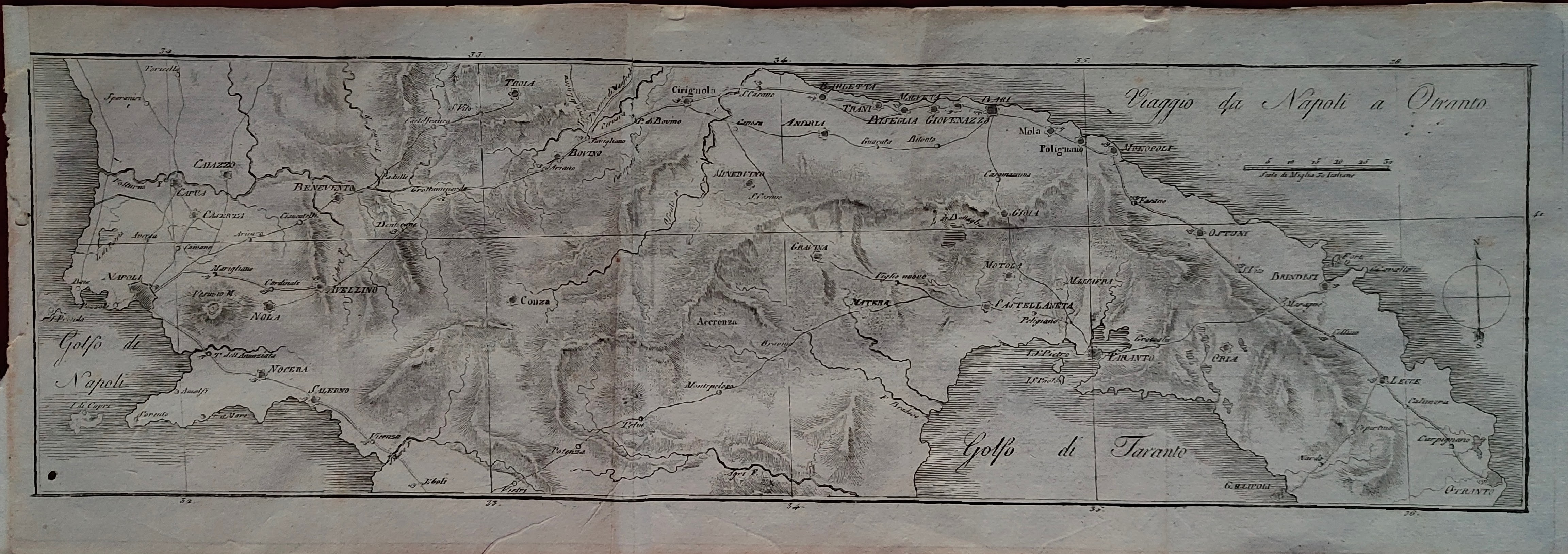
Viaggio da Napoli a Otranto
Author
Vallardi
Location shown in map
South Italy
Edition date
Circa 1820
Edition place
Editor
--
Atlas
Itinéraire d'Italie ou la description des voyages
Price
100 Euro
State
[mint/excellent/VERY GOOD/good/fair/mediocre/poor]
Color
Black/white
Verso
Blank
Size
Plate: cm (47 x 15) inches (18.5 x 5.91) Paper: cm (49 x 18) inches (19.29 x 7.09)
Technique
Copper engraving
Note
Reference
Wiki
Here for more info
In stock
Available
Info
info@thetreasuremaps.com
Code
#1352
×
![Viaggio da Napoli a Otranto by Vallardi, South Italy, Circa 1820]()
Map title
Giappone
Author
Location shown in map
Japan
Edition date
1820
Edition place
Milan
Editor
--
Atlas
Atlante Nuovo di Batelli & Fanfani
Price
Please ask: info@thetreasuremaps.com
State
[mint/EXCELLENT/very good/good/fair/mediocre/poor]
Color
Old outlined
Verso
Blank
Size
Plate: cm (24.1 x 20.3) inches (9.49 x 7.99) Paper: cm (45.7 x 27.9) inches (17.99 x 10.98)
Technique
--
Note
No particular notes for this maps
Reference
--
Wiki
Here for more info
In stock
Sold
Info
info@thetreasuremaps.com
Code
#0379
×
![Giappone by , Japan, 1820]()
Map title
Carta della parte della costa nord ovest dell'America
Author
Location shown in map
--
Edition date
1820
Edition place
Milan
Editor
--
Atlas
Atlante Nuovo di Batelli & Fanfani
Price
Please ask: info@thetreasuremaps.com
State
[mint/EXCELLENT/very good/good/fair/mediocre/poor]
Color
Black/white
Verso
Blank
Size
Plate: cm (21.6 x 26.7) inches (8.5 x 10.51) Paper: cm (21.6 x 26.7) inches (8.5 x 10.51)
Technique
Copper engraving
Note
No particular notes for this maps
Reference
--
Wiki
Here for more info
In stock
Sold
Info
info@thetreasuremaps.com
Code
#0381
×
![Carta della parte della costa nord ovest dell'America by , --, 1820]()
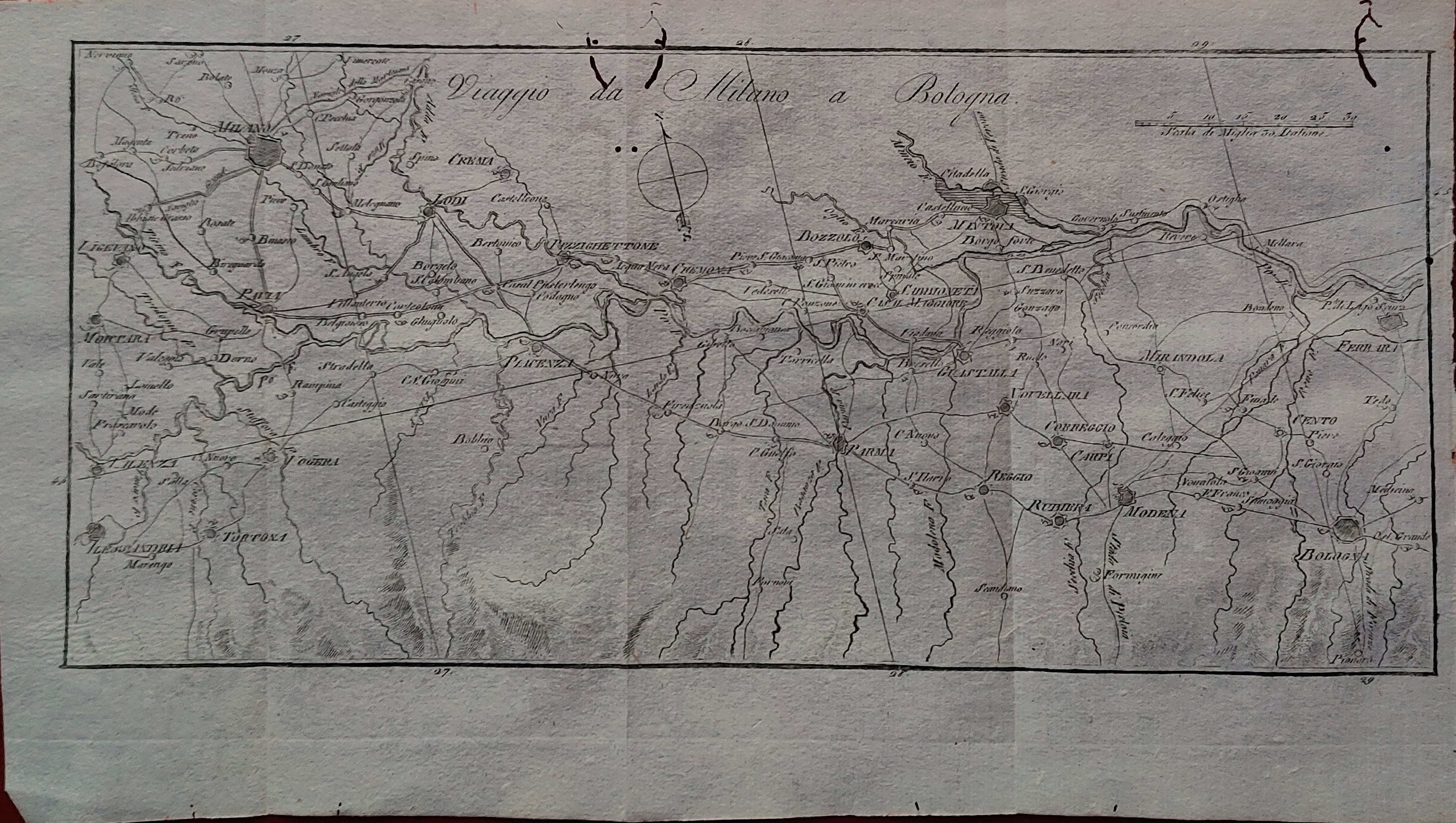
Map title
Viaggio da Milano a Bologna
Author
Vallardi
Location shown in map
North Italy
Edition date
Circa 1820
Edition place
Editor
--
Atlas
Itinéraire d'Italie ou la description des voyages
Price
100 Euro
State
[mint/excellent/VERY GOOD/good/fair/mediocre/poor]
Color
Black/white
Verso
Blank
Size
Plate: cm (30 x 14) inches (11.81 x 5.51) Paper: cm (32 x 18) inches (12.6 x 7.09)
Technique
Copper engraving
Note
Reference
Wiki
Here for more info
In stock
Available
Info
info@thetreasuremaps.com
Code
#1351
×
![Viaggio da Milano a Bologna by Vallardi, North Italy, Circa 1820]()
Map title
British colonies in north America
Author
Unknown
Location shown in map
North Usa & Canada
Edition date
1820
Edition place
London
Editor
--
Atlas
Published by Thomas Kelly
Price
Please ask: info@thetreasuremaps.com
State
[mint/EXCELLENT/very good/good/fair/mediocre/poor]
Color
Uncoloured
Verso
Blank
Size
Plate: cm (24.1 x 18.4) inches (9.49 x 7.24) Paper: cm (26.7 x 21) inches (10.51 x 8.27)
Technique
Copper engraving
Note
Map of English colonies in America
Reference
--
Wiki
Here for more info
In stock
Sold
Info
info@thetreasuremaps.com
Code
#0409
×
![British colonies in north America by Unknown, North Usa & Canada, 1820]()
Map title
Carta dell'arcipelago delle Indie Orientali
Author
Unknown
Location shown in map
--
Edition date
1820
Edition place
Milan
Editor
--
Atlas
Atlante Nuovo di Batelli & Fanfani
Price
Please ask: info@thetreasuremaps.com
State
[mint/EXCELLENT/very good/good/fair/mediocre/poor]
Color
Old outlined
Verso
Blank
Size
Plate: cm (45.7 x 29.2) inches (17.99 x 11.5) Paper: cm (45.7 x 29.2) inches (17.99 x 11.5)
Technique
--
Note
No particular notes for this maps
Reference
--
Wiki
Here for more info
In stock
Sold
Info
info@thetreasuremaps.com
Code
#0434
×
![Carta dell'arcipelago delle Indie Orientali by Unknown, --, 1820]()
Map title
United States
Author
Unknown
Location shown in map
USA
Edition date
1820
Edition place
London
Editor
--
Atlas
Published by Thomas Kelly
Price
Please ask: info@thetreasuremaps.com
State
[mint/EXCELLENT/very good/good/fair/mediocre/poor]
Color
Uncoloured
Verso
Blank
Size
Plate: cm (24.1 x 18.4) inches (9.49 x 7.24) Paper: cm (26.7 x 21) inches (10.51 x 8.27)
Technique
Copper engraving
Note
Map of United States in early XIX. Big Georgia, west and east Florida.
Reference
--
Wiki
Here for more info
In stock
Sold
Info
info@thetreasuremaps.com
Code
#0408
×
![United States by Unknown, USA, 1820]()
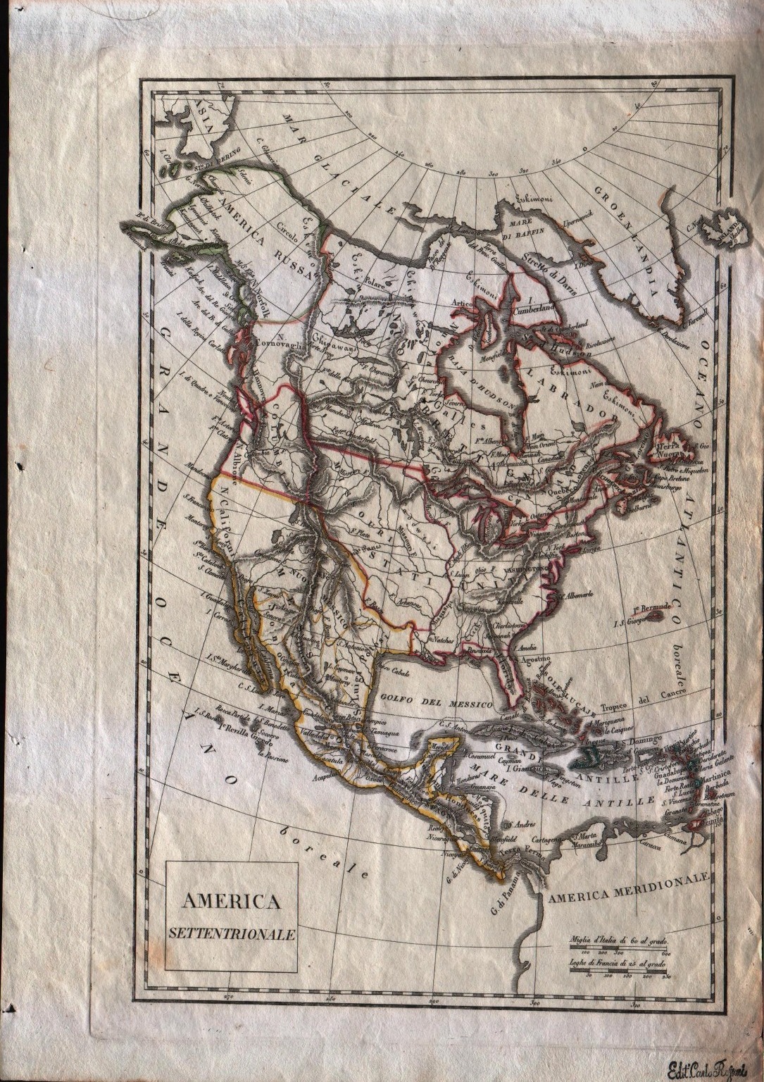
Map title
America Settentrionale
Author
Unknown
Location shown in map
North America
Edition date
1822
Edition place
Milan
Editor
--
Atlas
Printed by Carlo Rossari from an unknown atlas.
Price
125 Euro
State
[mint/excellent/very good/GOOD/fair/mediocre/poor] It has a small hole in the center.
Color
Old outlined
Verso
Blank
Size
Plate: cm (20.3 x 31.8) inches (7.99 x 12.52) Paper: cm (38.1 x 26.7) inches (15 x 10.51)
Technique
Copper engraving
Note
Italian map of North America. Texas is still part of Mexico. Note the Columbia borders.
Reference
--
Wiki
Here for more info
In stock
Available
Info
info@thetreasuremaps.com
Code
#0089
×
![America Settentrionale by Unknown, North America, 1822]()