News
Map title
A plan of the port of Genoa
Author
Michelot
Location shown in map
Genoa
Edition date
Circa 1720
Edition place
London
Editor
Atlas
London Magazine
Price
150 Euro
State
[mint/EXCELLENT/very good/good/fair/mediocre/poor]
Color
Black/white
Verso
Blank
Size
Plate: cm (11 x 17) inches (4.33 x 6.69) Paper: cm (13 x 21) inches (5.12 x 8.27)
Technique
Copper engraving
Note
Reference
Wiki
Here for more info
In stock
Available
Info
info@thetreasuremaps.com
Code
#1360
×
![A plan of the port of Genoa by Michelot, Genoa, Circa 1720]()
Map title
A Topographical Map of the Republick of Genova
Author
Gravier
Location shown in map
Liguria
Edition date
1784
Edition place
Genoa
Editor
Gravier
Atlas
Price
2500 Euro
State
[mint/EXCELLENT/very good/good/fair/mediocre/poor]
Color
Black/white
Verso
Blank
Size
Plate: cm (1855 x 1060) inches (730.31 x 417.32) Paper: cm (1855 x 1060) inches (730.31 x 417.32)
Technique
Copper engraving
Note
Reference
L.Tricerri, Catalog of Maps of Liguria R_093
Wiki
Here for more info
In stock
Available
Info
info@thetreasuremaps.com
Code
#1361
×
![A Topographical Map of the Republick of Genova by Gravier, Liguria, 1784]()
Map title
Italy
Author
Rizzi Zannoni
Location shown in map
All Italy
Edition date
1814
Edition place
London
Editor
Mawman
Atlas
Price
1000 Euro
State
[mint/EXCELLENT/very good/good/fair/mediocre/poor]
Color
Colors
Verso
Blank
Size
Plate: cm (42 x 100) inches (16.54 x 39.37) Paper: cm (46 x 103) inches (18.11 x 40.55)
Technique
Copper engraving
Note
Reference
Wiki
Here for more info
In stock
Available
Info
info@thetreasuremaps.com
Code
#1394
×
![Italy by Rizzi Zannoni, All Italy, 1814]()
Map title
Author
Schedel
Location shown in map
Eichstatt
Edition date
1493
Edition place
Nuremberg
Editor
Atlas
Liber Chronicarum
Price
150 Euro
State
[mint/EXCELLENT/very good/good/fair/mediocre/poor]
Color
Black/white
Verso
Latin text
Size
Plate: cm (23 x 20) inches (9.06 x 7.87) Paper: cm (29 x 42) inches (11.42 x 16.54)
Technique
Woodcut
Note
The woodcut plate dates back to 1493
Reference
--
Wiki
Here for more info
In stock
Available
Info
info@thetreasuremaps.com
Code
#1393
×
![by Schedel, Eichstatt, 1493]()
Map title
Author
Schedel
Location shown in map
Tiburtina
Edition date
1493
Edition place
Nuremberg
Editor
Atlas
Liber Chronicarum
Price
150 Euro
State
[mint/EXCELLENT/very good/good/fair/mediocre/poor]
Color
Black/white
Verso
Latin text
Size
Plate: cm (23 x 20) inches (9.06 x 7.87) Paper: cm (29 x 42) inches (11.42 x 16.54)
Technique
Woodcut
Note
The woodcut plate dates back to 1493
Reference
--
Wiki
Here for more info
In stock
Available
Info
info@thetreasuremaps.com
Code
#1392
×
![by Schedel, Tiburtina, 1493]()
Map title
Author
Schedel
Location shown in map
Rhodes
Edition date
1493
Edition place
Nuremberg
Editor
Atlas
Liber Chronicarum
Price
150 Euro
State
[mint/EXCELLENT/very good/good/fair/mediocre/poor]
Color
Black/white
Verso
German text
Size
Plate: cm (23 x 20) inches (9.06 x 7.87) Paper: cm (31 x 46) inches (12.2 x 18.11)
Technique
Woodcut
Note
The woodcut plate dates back to 1493
Reference
--
Wiki
Here for more info
In stock
Available
Info
info@thetreasuremaps.com
Code
#1391
×
![by Schedel, Rhodes, 1493]()
Map title
Genua
Author
Schedel
Location shown in map
Genoa
Edition date
1493
Edition place
Nuremberg
Editor
Atlas
Liber Chronicarum
Price
1000 Euro
State
[mint/EXCELLENT/very good/good/fair/mediocre/poor]
Color
Black/white
Verso
German text
Size
Plate: cm (23 x 20) inches (9.06 x 7.87) Paper: cm (31 x 46) inches (12.2 x 18.11)
Technique
Woodcut
Note
The woodcut plate dates back to 1493
Reference
--
Wiki
Here for more info
In stock
Available
Info
info@thetreasuremaps.com
Code
#1390
×
![Genua by Schedel, Genoa, 1493]()
Map title
Nuove scoperte dei russi al nord del mare del sud
Author
Zatta
Location shown in map
Tartaria
Edition date
1776
Edition place
Venice
Editor
Atlas
Atlante novissimo, illustrato ed accresciuto sulle osservazioni e scoperte fatte dai più celebri e più recenti geografi
Price
600 Euro
State
[mint/EXCELLENT/very good/good/fair/mediocre/poor]
Color
Old colors
Verso
Blank
Size
Plate: cm (40 x 30) inches (15.75 x 11.81) Paper: cm (50 x 38) inches (19.69 x 14.96)
Technique
Copper engraving
Note
Reference
Wiki
Here for more info
In stock
Available
Info
info@thetreasuremaps.com
Code
#1389
×
![Nuove scoperte dei russi al nord del mare del sud by Zatta, Tartaria, 1776]()
Map title
La baia d'Hudson terra di Labrador
Author
Zatta
Location shown in map
Canada
Edition date
1776
Edition place
Venice
Editor
Atlas
Atlante novissimo, illustrato ed accresciuto sulle osservazioni e scoperte fatte dai più celebri e più recenti geografi
Price
200 Euro
State
[mint/EXCELLENT/very good/good/fair/mediocre/poor]
Color
Old colors
Verso
Blank
Size
Plate: cm (40 x 30) inches (15.75 x 11.81) Paper: cm (50 x 38) inches (19.69 x 14.96)
Technique
Copper engraving
Note
Reference
Wiki
Here for more info
In stock
Available
Info
info@thetreasuremaps.com
Code
#1388
×
![La baia d'Hudson terra di Labrador by Zatta, Canada, 1776]()
Map title
L'America divisa nei suoi principali stati
Author
Zatta
Location shown in map
All America
Edition date
1776
Edition place
Venice
Editor
Atlas
Atlante novissimo, illustrato ed accresciuto sulle osservazioni e scoperte fatte dai più celebri e più recenti geografi
Price
700 Euro
State
[mint/EXCELLENT/very good/good/fair/mediocre/poor]
Color
Old colors
Verso
Blank
Size
Plate: cm (40 x 30) inches (15.75 x 11.81) Paper: cm (50 x 38) inches (19.69 x 14.96)
Technique
Copper engraving
Note
Reference
Wiki
Here for more info
In stock
Available
Info
info@thetreasuremaps.com
Code
#1387
×
![L'America divisa nei suoi principali stati by Zatta, All America, 1776]()
Map title
Nuove scoperte fatte nel 1765 67 e 69 nel mare del sud
Author
Zatta
Location shown in map
Oceania
Edition date
1776
Edition place
Venice
Editor
Atlas
Atlante novissimo, illustrato ed accresciuto sulle osservazioni e scoperte fatte dai più celebri e più recenti geografi
Price
1300 Euro
State
[mint/EXCELLENT/very good/good/fair/mediocre/poor]
Color
Old colors
Verso
Blank
Size
Plate: cm (40 x 31) inches (15.75 x 12.2) Paper: cm (50 x 38) inches (19.69 x 14.96)
Technique
Copper engraving
Note
Reference
Wiki
Here for more info
In stock
Available
Info
info@thetreasuremaps.com
Code
#1386
×
![Nuove scoperte fatte nel 1765 67 e 69 nel mare del sud by Zatta, Oceania, 1776]()
Map title
La Nuova Zelanda
Author
Zatta
Location shown in map
New Zeland
Edition date
1776
Edition place
Venice
Editor
Atlas
Atlante novissimo, illustrato ed accresciuto sulle osservazioni e scoperte fatte dai più celebri e più recenti geografi
Price
1600 Euro
State
[mint/EXCELLENT/very good/good/fair/mediocre/poor]
Color
Old colors
Verso
Blank
Size
Plate: cm (35 x 44) inches (13.78 x 17.32) Paper: cm (38 x 50) inches (14.96 x 19.69)
Technique
Copper engraving
Note
Reference
Wiki
Here for more info
In stock
Available
Info
info@thetreasuremaps.com
Code
#1385
×
![La Nuova Zelanda by Zatta, New Zeland, 1776]()
Map title
Carta Geographica, la quale rappresenta lo Stato della Republica di Genova
Author
Homann
Location shown in map
Liguria
Edition date
1743
Edition place
Nuremberg
Editor
Atlas
Price
900 Euro
State
[mint/EXCELLENT/very good/good/fair/mediocre/poor]
Color
Old colors
Verso
Blank
Size
Plate: cm (56 x 50) inches (22.05 x 19.69) Paper: cm (63 x 52) inches (24.8 x 20.47)
Technique
Copper engraving
Note
Framed
Reference
Wiki
Here for more info
In stock
Available
Info
info@thetreasuremaps.com
Code
#1384
×
![Carta Geographica, la quale rappresenta lo Stato della Republica di Genova by Homann, Liguria, 1743]()
Map title
Asia Minor in suas partes seu provincias divisa
Author
Vaugondy
Location shown in map
Turkey
Edition date
Circa 1760
Edition place
Venice
Editor
Remondini
Atlas
Atlas Universel
Price
200 Euro
State
[mint/EXCELLENT/very good/good/fair/mediocre/poor]
Color
Old colors
Verso
Blank
Size
Plate: cm (60 x 47) inches (23.62 x 18.5) Paper: cm (62 x 50) inches (24.41 x 19.69)
Technique
Copper engraving
Note
Reference
Wiki
Here for more info
In stock
Available
Info
info@thetreasuremaps.com
Code
#1383
×
![Asia Minor in suas partes seu provincias divisa by Vaugondy, Turkey, Circa 1760]()
Map title
Natoliae quae olim Asia Minor nova descriptio
Author
Ortelius
Location shown in map
Turkey
Edition date
1584
Edition place
Antwerp
Editor
Atlas
Theatrum Orbis Terrarum
Price
350 Euro
State
[mint/EXCELLENT/very good/good/fair/mediocre/poor]
Color
Old colors
Verso
Latin text
Size
Plate: cm (22 x 32) inches (8.66 x 12.6) Paper: cm (28 x 38) inches (11.02 x 14.96)
Technique
Copper engraving
Note
Reference
Van Den Broecke 225
Wiki
Here for more info
In stock
Available
Info
info@thetreasuremaps.com
Code
#1381
×
![Natoliae quae olim Asia Minor nova descriptio by Ortelius, Turkey, 1584]()
Map title
Natolia quae olim Asia Minor
Author
Blaeu
Location shown in map
Turkey
Edition date
Circa 1640
Edition place
Amsterdam
Editor
Atlas
Theatrum Orbis Terrarum, Sive Atlas Novis
Price
300 Euro
State
[mint/EXCELLENT/very good/good/fair/mediocre/poor]
Color
Old colors
Verso
Blank
Size
Plate: cm (50 x 38) inches (19.69 x 14.96) Paper: cm (55 x 45) inches (21.65 x 17.72)
Technique
Copper engraving
Note
Reference
Wiki
Here for more info
In stock
Available
Info
info@thetreasuremaps.com
Code
#1382
×
![Natolia quae olim Asia Minor by Blaeu, Turkey, Circa 1640]()
Map title
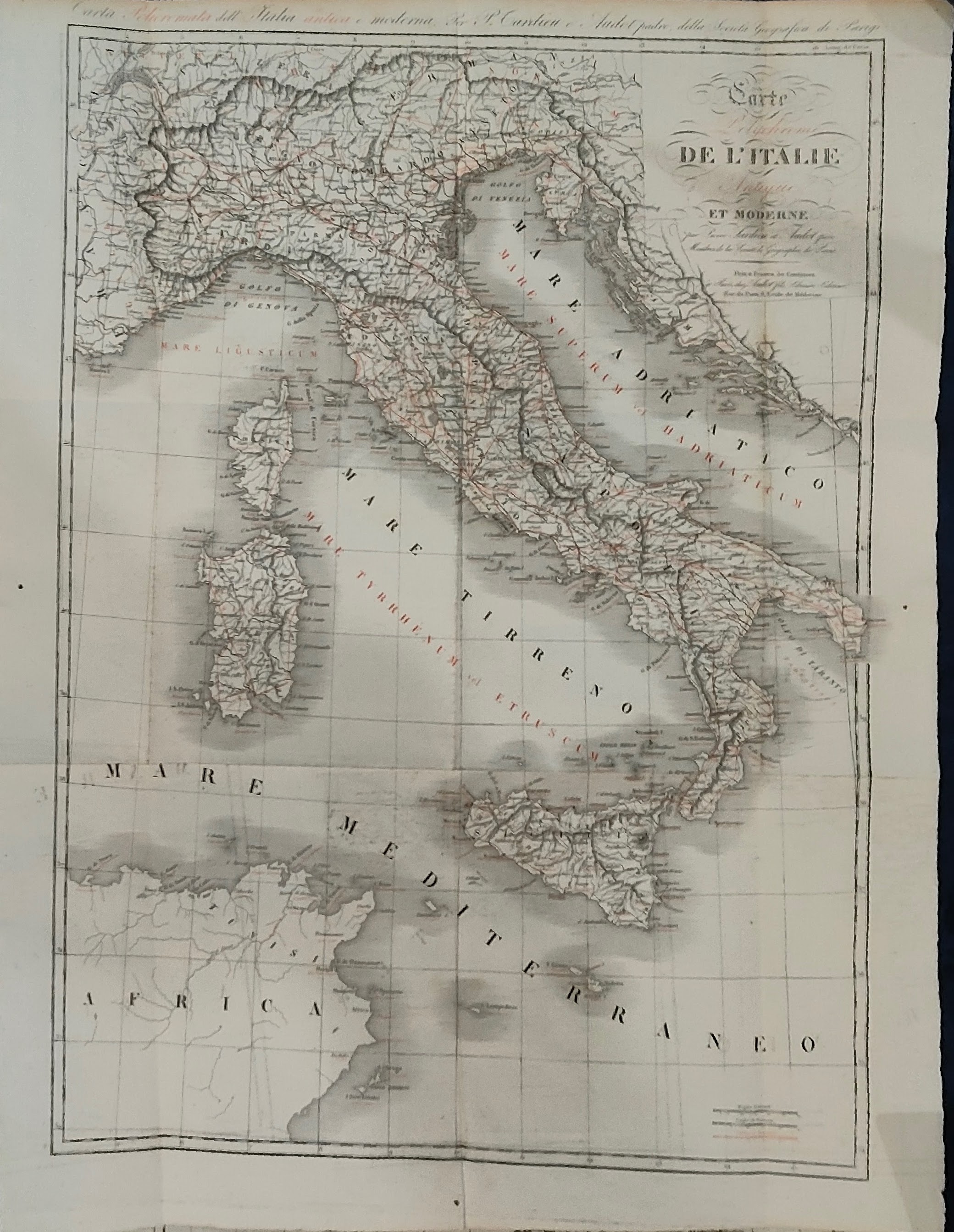
Carte polycrhome de'Italie antique et moderne
Author
Tardieu
Location shown in map
Italy
Edition date
Circa 1830
Edition place
Paris
Editor
Audot
Atlas
Price
150 Euro
State
[mint/excellent/VERY GOOD/good/fair/mediocre/poor]
Color
Old colors
Verso
Blank
Size
Plate: cm (40 x 55) inches (15.75 x 21.65) Paper: cm (46 x 60) inches (18.11 x 23.62)
Technique
Steel engraving
Note
Reference
Wiki
Here for more info
In stock
Available
Info
info@thetreasuremaps.com
Code
#1380
×
![Carte polycrhome de'Italie antique et moderne by Tardieu, Italy, Circa 1830]()
Map title
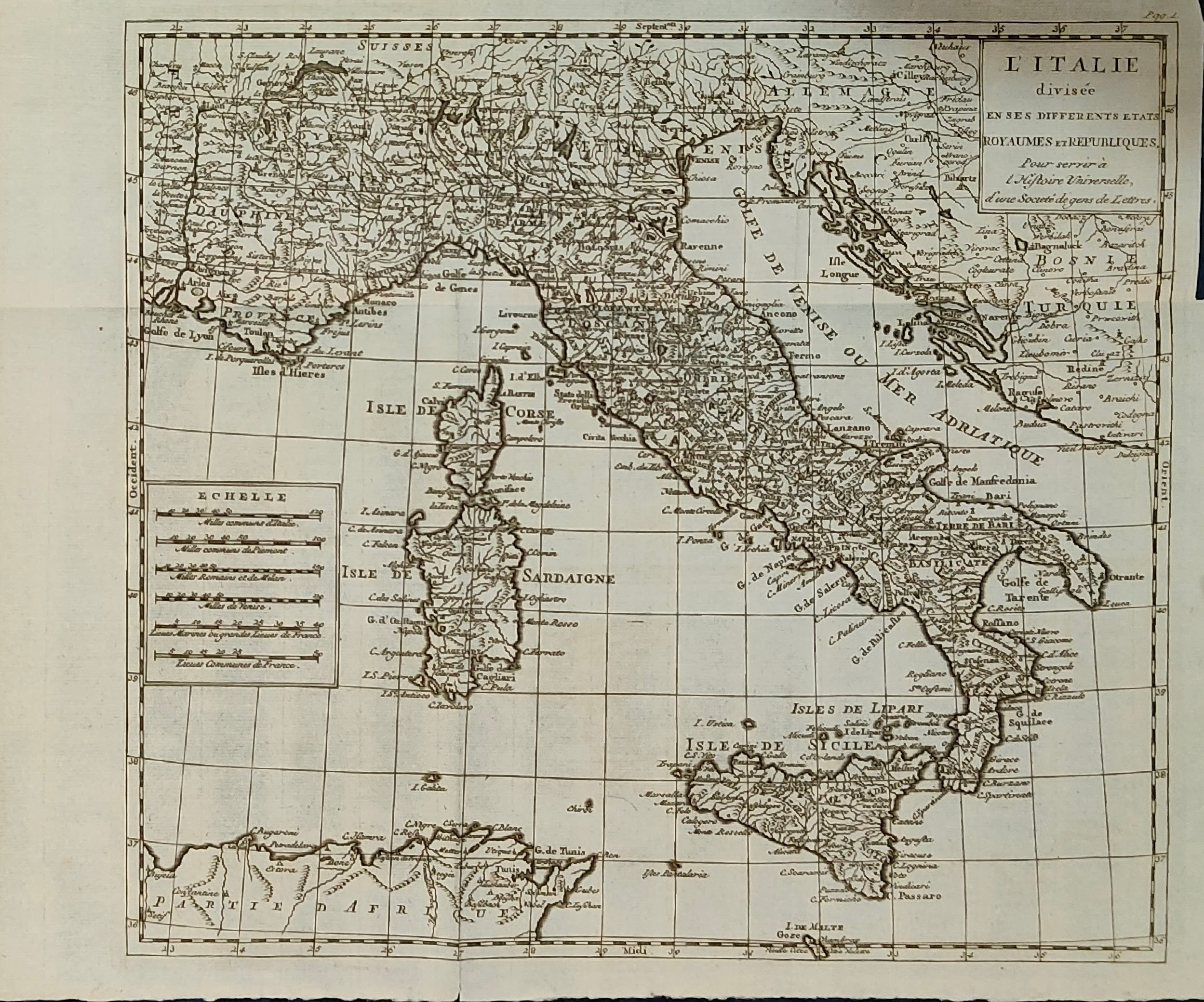
L'Italie divisee en ses different etats royaumes et republiques
Author
Location shown in map
Italy
Edition date
Circa 1790
Edition place
Paris
Editor
Atlas
L historie universelle d une societe de gens de Lettres
Price
175 Euro
State
[mint/EXCELLENT/very good/good/fair/mediocre/poor]
Color
Black/white
Verso
Blank
Size
Plate: cm (34 x 30) inches (13.39 x 11.81) Paper: cm (41 x 33) inches (16.14 x 12.99)
Technique
Copper engraving
Note
Reference
R.Borri L'Italia nelle antiche carte pag.267
Wiki
Here for more info
In stock
Available
Info
info@thetreasuremaps.com
Code
#1379
×
![L'Italie divisee en ses different etats royaumes et republiques by , Italy, Circa 1790]()
Map title
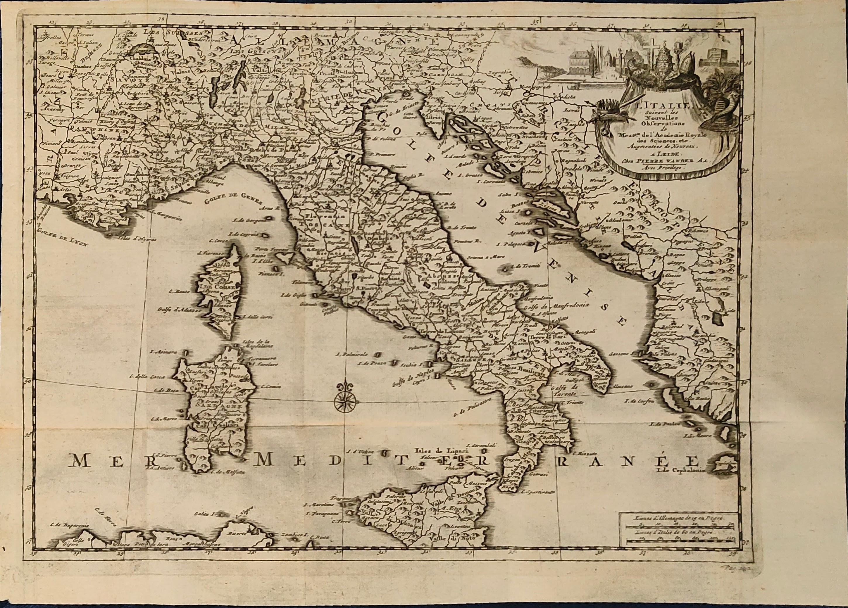
L'Italie suivant les nouvelles Observations
Author
Vander
Location shown in map
Italy
Edition date
Circa 1714
Edition place
Leide
Editor
Atlas
Atlas tres exact et fort commode put toutes
Price
200 Euro
State
[mint/EXCELLENT/very good/good/fair/mediocre/poor]
Color
Black/white
Verso
Blank
Size
Plate: cm (29 x 22) inches (11.42 x 8.66) Paper: cm (34 x 24) inches (13.39 x 9.45)
Technique
Copper engraving
Note
Reference
R.Borri L'Italia nelle antiche carte pag.218
Wiki
Here for more info
In stock
Available
Info
info@thetreasuremaps.com
Code
#1378
×
![L'Italie suivant les nouvelles Observations by Vander, Italy, Circa 1714]()

Map title
Le reseau del cables francais
Author
Location shown in map
South Europe
Edition date
1932
Edition place
Paris
Editor
Atlas
Price
50 Euro
State
[mint/EXCELLENT/very good/good/fair/mediocre/poor]
Color
Black/white
Verso
Blank
Size
Plate: cm (37 x 27) inches (14.57 x 10.63) Paper: cm (37 x 27) inches (14.57 x 10.63)
Technique
Steel engraving
Note
Reference
Wiki
Here for more info
In stock
Available
Info
info@thetreasuremaps.com
Code
#1365
×
![Le reseau del cables francais by , South Europe, 1932]()