News

Map title
L' Asia
Author
Sanson
Location shown in map
Asia
Edition date
Circa 1725
Edition place
Venice
Editor
Atlas
Price
125 Euro
State
[mint/EXCELLENT/very good/good/fair/mediocre/poor]
Color
Black/white
Verso
Blank
Size
Plate: cm (17 x 17) inches (6.69 x 6.69) Paper: cm (16 x 14) inches (6.3 x 5.51)
Technique
Copper engraving
Note
Reference
Wiki
Here for more info
In stock
Available
Info
info@thetreasuremaps.com
Code
#1190
×
![L' Asia by Sanson, Asia, Circa 1725]()
Map title
Elba isola olim Ilua
Author
Magini
Location shown in map
Elba
Edition date
1620
Edition place
Bolonia
Editor
Magini
Atlas
Italia
Price
350 Euro
State
[mint/EXCELLENT/very good/good/fair/mediocre/poor]
Color
Black/white
Verso
Blank
Size
Plate: cm (23 x 17) inches (9.06 x 6.69) Paper: cm (41 x 28) inches (16.14 x 11.02)
Technique
Copper engraving
Note
Reference
--
Wiki
Here for more info
In stock
Available
Info
info@thetreasuremaps.com
Code
#1171
×
![Elba isola olim Ilua by Magini, Elba, 1620]()
Map title
Carta dell'isola di Santa Lucia
Author
Bellin
Location shown in map
Sant Lucia
Edition date
1760
Edition place
Paris
Editor
--
Atlas
Historie General des Voyages -- Prevost
Price
150 Euro
State
[mint/EXCELLENT/very good/good/fair/mediocre/poor]
Color
Black/white
Verso
Blank
Size
Plate: cm (30 x 20) inches (11.81 x 7.87) Paper: cm (33 x 23) inches (12.99 x 9.06)
Technique
Copper engraving
Note
Reference
--
Wiki
Here for more info
In stock
Available
Info
info@thetreasuremaps.com
Code
#1172
×
![Carta dell'isola di Santa Lucia by Bellin, Sant Lucia, 1760]()
Map title
Asia recens summa cura delineata
Author
Hondius
Location shown in map
Asia
Edition date
1631
Edition place
Amsterdam
Editor
Atlas
Price
1200 Euro
State
[mint/EXCELLENT/very good/good/fair/mediocre/poor]
Color
Old colors
Verso
Latin text
Size
Plate: cm (51 x 40) inches (20.08 x 15.75) Paper: cm (56 x 48) inches (22.05 x 18.9)
Technique
Copper engraving
Note
Reference
Wiki
Here for more info
In stock
Available
Info
info@thetreasuremaps.com
Code
#1175
×
![Asia recens summa cura delineata by Hondius, Asia, 1631]()
Map title
Pedmontanae Vicinorumque Regionum Auctore Iacobo Castaldo Descrip.
Author
Ortelius
Location shown in map
Piedmont & Liguria, North west Italy
Edition date
1597
Edition place
Antwerp
Editor
--
Atlas
Theatrum Orbis Terrarum
Price
600 Euro
State
[mint/EXCELLENT/very good/good/fair/mediocre/poor]
Color
Old colors
Verso
Latin text pag 77
Size
Plate: cm (49 x 35.6) inches (19.29 x 14.02) Paper: cm (57 x 44) inches (22.44 x 17.32)
Technique
Copper engraving
Note
Reference
Van Den Broecke 175
Wiki
Here for more info
In stock
Available
Info
info@thetreasuremaps.com
Code
#1176
×
![Pedmontanae Vicinorumque Regionum Auctore Iacobo Castaldo Descrip. by Ortelius, Piedmont & Liguria, North west Italy, 1597]()
Map title
Italia
Author
Juan Vilanova
Location shown in map
Italy
Edition date
1877
Edition place
Madrid
Editor
Astort Hermanos
Atlas
Atlas Geografico Universal
Price
150 Euro
State
[mint/EXCELLENT/very good/good/fair/mediocre/poor]
Color
Old colors
Verso
Blank
Size
Plate: cm (34 x 28) inches (13.39 x 11.02) Paper: cm (80 x 59) inches (31.5 x 23.23)
Technique
Steel engraving
Note
Reference
Wiki
Here for more info
In stock
Available
Info
info@thetreasuremaps.com
Code
#1177
×
![Italia by Juan Vilanova, Italy, 1877]()
Map title
Carta della Danimarca
Author
Kitchin
Location shown in map
Denmark
Edition date
Circa 1760
Edition place
Paris
Editor
Atlas
Price
75 Euro
State
[mint/EXCELLENT/very good/good/fair/mediocre/poor]
Color
Black/white
Verso
Blank
Size
Plate: cm (34 x 30) inches (13.39 x 11.81) Paper: cm (39 x 33) inches (15.35 x 12.99)
Technique
Copper engraving
Note
Reference
Wiki
Here for more info
In stock
Available
Info
info@thetreasuremaps.com
Code
#1178
×
![Carta della Danimarca by Kitchin, Denmark, Circa 1760]()
Map title
Piano della citta di Copenaghen
Author
Kitchin
Location shown in map
Copenaghen
Edition date
Circa 1760
Edition place
Paris
Editor
Atlas
Price
75 Euro
State
[mint/EXCELLENT/very good/good/fair/mediocre/poor]
Color
Black/white
Verso
Blank
Size
Plate: cm (30 x 26) inches (11.81 x 10.24) Paper: cm (39 x 30) inches (15.35 x 11.81)
Technique
Copper engraving
Note
Reference
Wiki
Here for more info
In stock
Available
Info
info@thetreasuremaps.com
Code
#1179
×
![Piano della citta di Copenaghen by Kitchin, Copenaghen, Circa 1760]()
Map title
Genuense Territorium
Author
Jansson
Location shown in map
Genuense Territorium
Edition date
1673
Edition place
Amsterdam
Editor
--
Atlas
Atlas Minor
Price
250 Euro
State
[mint/EXCELLENT/very good/good/fair/mediocre/poor]
Color
Old colors
Verso
Blank
Size
Plate: cm (24 x 18) inches (9.45 x 7.09) Paper: cm (27 x 20) inches (10.63 x 7.87)
Technique
Copper engraving
Note
Reference
Wiki
Here for more info
In stock
Available
Info
info@thetreasuremaps.com
Code
#1180
Genuense Territorium
Author
Jansson
Location shown in map
Genuense Territorium
Edition date
1673
Edition place
Amsterdam
Editor
--
Atlas
Atlas Minor
Price
250 Euro
State
[mint/EXCELLENT/very good/good/fair/mediocre/poor]
Color
Old colors
Verso
Blank
Size
Plate: cm (24 x 18) inches (9.45 x 7.09) Paper: cm (27 x 20) inches (10.63 x 7.87)
Technique
Copper engraving
Note
Reference
Wiki
Here for more info
In stock
Available
Info
info@thetreasuremaps.com
Code
#1180
×
![Genuense Territorium by Jansson, Genuense Territorium, 1673]()
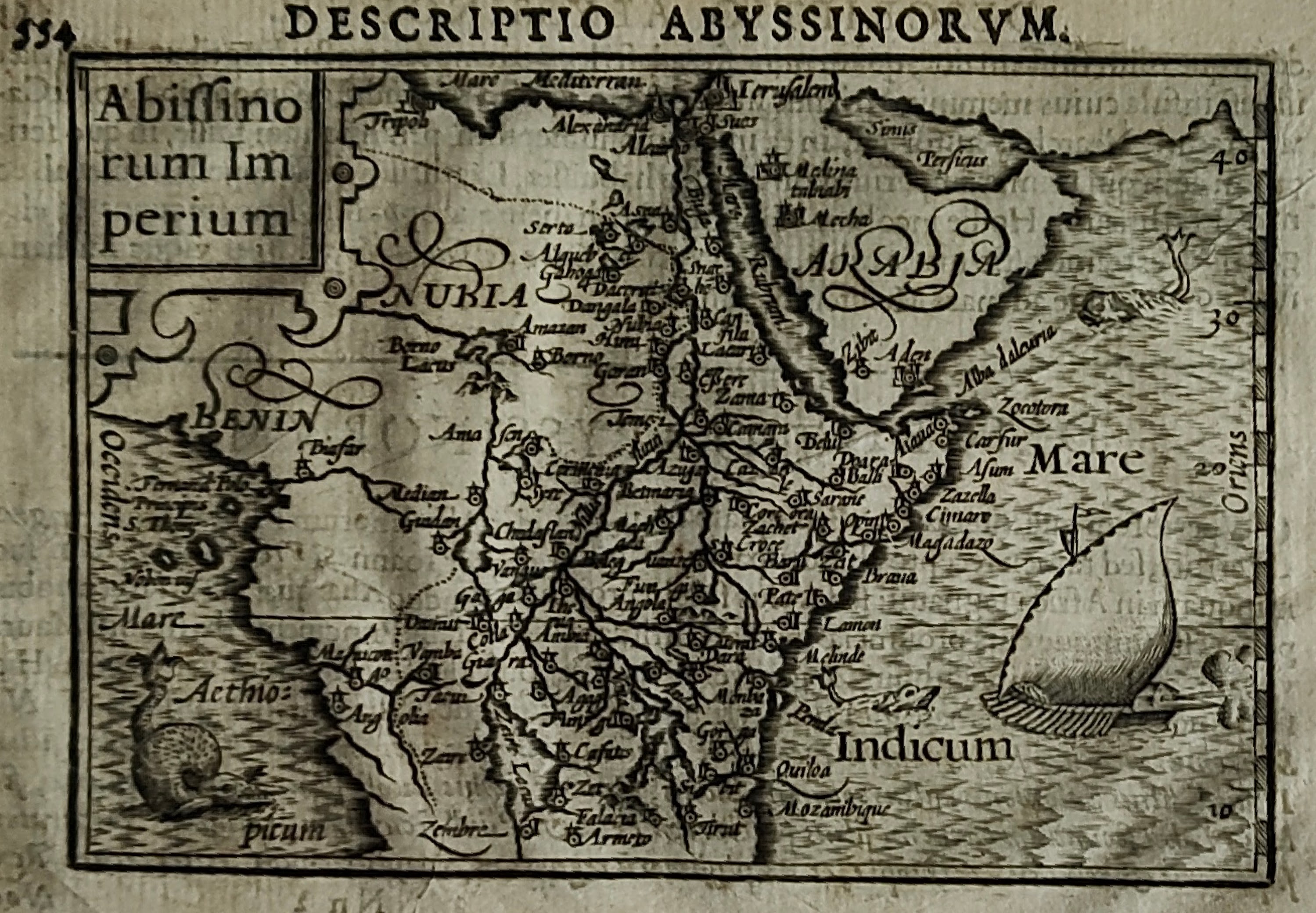
Map title
Abissinorum imperium
Author
Bertius
Location shown in map
Africa
Edition date
1600
Edition place
Amsterdam
Editor
--
Atlas
Tabularum geographicarum contractarum
Price
200 Euro
State
[mint/EXCELLENT/very good/good/fair/mediocre/poor]
Color
Black/white
Verso
Latin text
Size
Plate: cm (12 x 8) inches (4.72 x 3.15) Paper: cm (18 x 12) inches (7.09 x 4.72)
Technique
Copper engraving
Note
Reference
Wiki
Here for more info
In stock
Available
Info
info@thetreasuremaps.com
Code
#1182
×
![Abissinorum imperium by Bertius, Africa, 1600]()
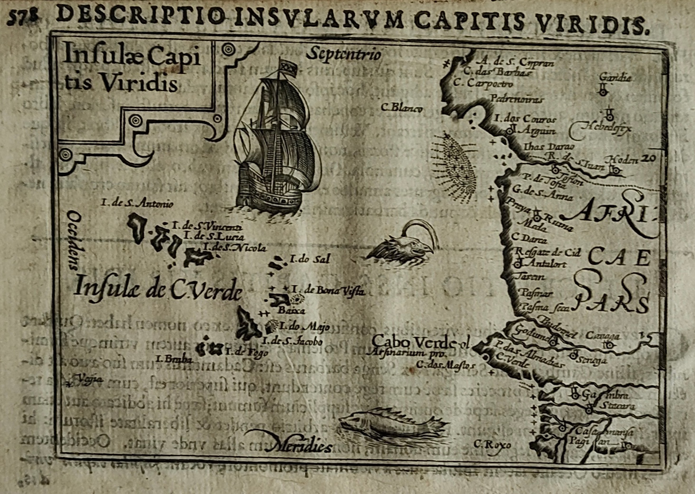
Map title
Insulae capitis viridis
Author
Bertius
Location shown in map
Cape Verde
Edition date
1600
Edition place
Amsterdam
Editor
--
Atlas
Tabularum geographicarum contractarum
Price
200 Euro
State
[mint/EXCELLENT/very good/good/fair/mediocre/poor]
Color
Black/white
Verso
Latin text
Size
Plate: cm (12 x 8) inches (4.72 x 3.15) Paper: cm (18 x 12) inches (7.09 x 4.72)
Technique
Copper engraving
Note
Reference
Wiki
Here for more info
In stock
Available
Info
info@thetreasuremaps.com
Code
#1183
×
![Insulae capitis viridis by Bertius, Cape Verde, 1600]()
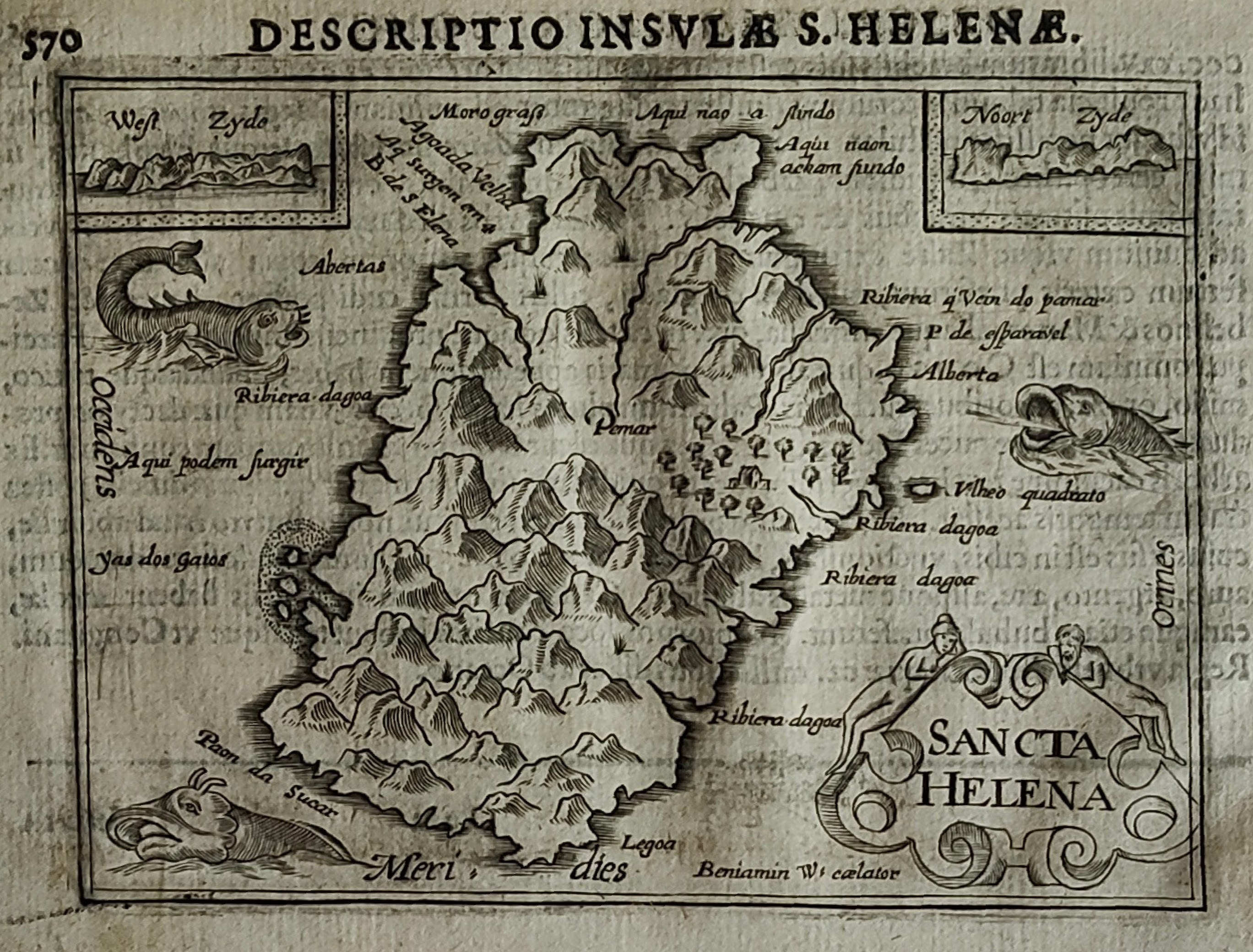
Map title
Sancta Helena
Author
Bertius
Location shown in map
S.Helena
Edition date
1600
Edition place
Amsterdam
Editor
--
Atlas
Tabularum geographicarum contractarum
Price
200 Euro
State
[mint/EXCELLENT/very good/good/fair/mediocre/poor]
Color
Black/white
Verso
Latin text
Size
Plate: cm (12 x 8) inches (4.72 x 3.15) Paper: cm (18 x 12) inches (7.09 x 4.72)
Technique
Copper engraving
Note
Reference
Wiki
Here for more info
In stock
Available
Info
info@thetreasuremaps.com
Code
#1184
×
![Sancta Helena by Bertius, S.Helena, 1600]()
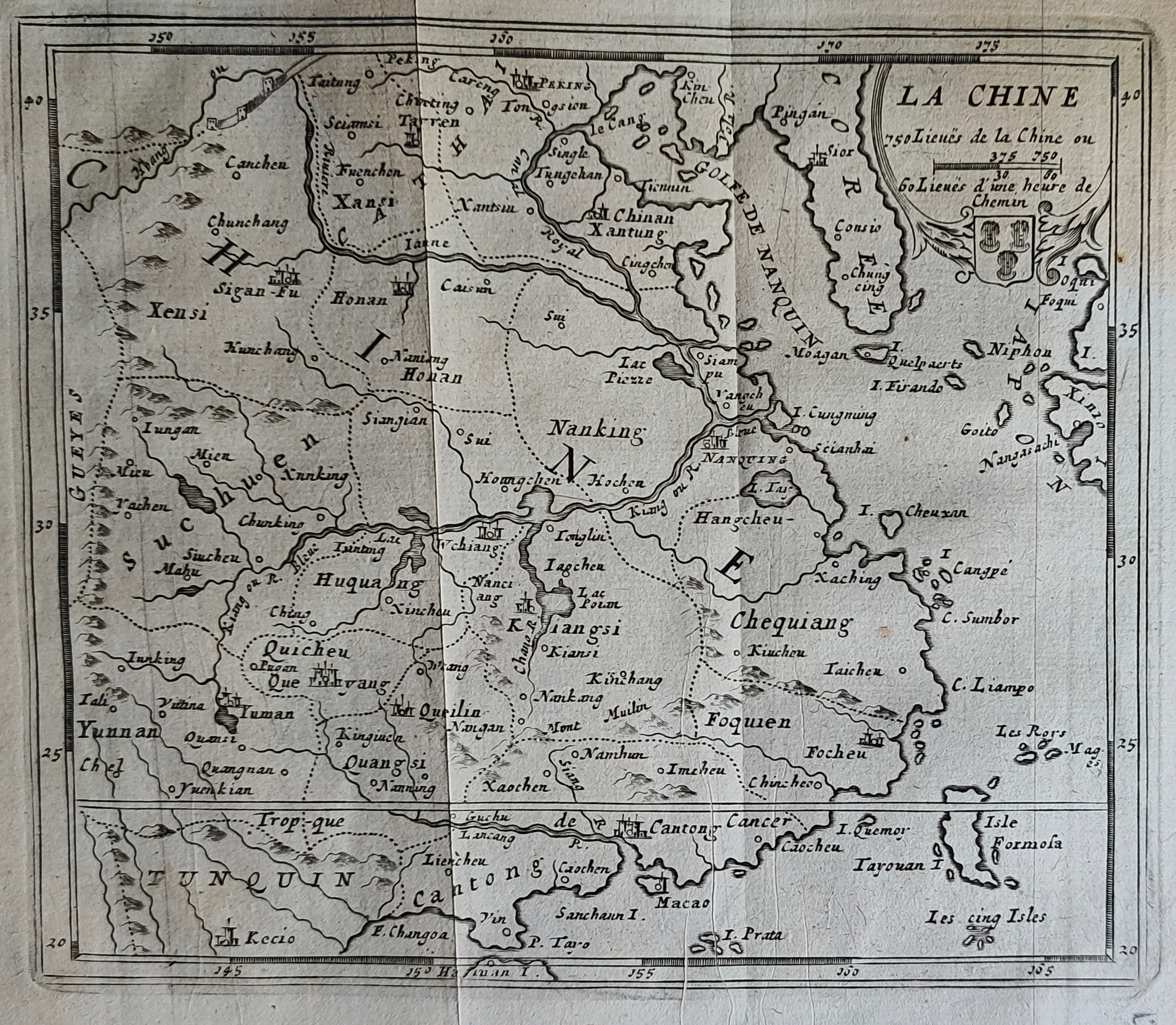
Map title
La Chine
Author
Peeters
Location shown in map
China
Edition date
1692
Edition place
Antwerp
Editor
Atlas
Imperii Sinarum nova descriptio
Price
150 Euro
State
[mint/EXCELLENT/very good/good/fair/mediocre/poor]
Color
Black/white
Verso
Blank
Size
Plate: cm (16 x 13) inches (6.3 x 5.12) Paper: cm (19 x 18) inches (7.48 x 7.09)
Technique
Copper engraving
Note
Reference
--
Wiki
Here for more info
In stock
Available
Info
info@thetreasuremaps.com
Code
#1185
×
![La Chine by Peeters, China, 1692]()
Map title
Italie divisee en regiones par Cesar Auguste
Author
Location shown in map
Italy
Edition date
Circa 1750
Edition place
Paris
Editor
Atlas
Price
175 Euro
State
[mint/EXCELLENT/very good/good/fair/mediocre/poor]
Color
Color
Verso
Blank
Size
Plate: cm (39 x 30) inches (15.35 x 11.81) Paper: cm (43 x 35) inches (16.93 x 13.78)
Technique
Copper engraving
Note
Reference
Wiki
Here for more info
In stock
Available
Info
info@thetreasuremaps.com
Code
#1170
×
![Italie divisee en regiones par Cesar Auguste by , Italy, Circa 1750]()
Map title
Italia
Author
Location shown in map
Italy
Edition date
Circa 1990
Edition place
Madrid
Editor
Atlas
Price
175 Euro
State
[mint/excellent/VERY GOOD/good/fair/mediocre/poor]
Color
Color
Verso
Blank
Size
Plate: cm (50 x 70) inches (19.69 x 27.56) Paper: cm (50 x 70) inches (19.69 x 27.56)
Technique
Note
Reference
Wiki
Here for more info
In stock
Available
Info
info@thetreasuremaps.com
Code
#1174
×
![Italia by , Italy, Circa 1990]()
Map title
L'Italia con le sue Poste e strade principali
Author
Cantelli da Vignola
Location shown in map
Italy
Edition date
Circa 1730
Edition place
Augsburg
Editor
Seutter
Atlas
Price
500 Euro
State
[mint/excellent/very good/GOOD/fair/mediocre/poor]
Color
Old colors
Verso
Blank
Size
Plate: cm (57 x 49) inches (22.44 x 19.29) Paper: cm (64 x 56) inches (25.2 x 22.05)
Technique
Copper engraving
Note
Reference
R.Borri L'Italia nelle antiche carte pag.191
Wiki
Here for more info
In stock
Available
Info
info@thetreasuremaps.com
Code
#1167
×
![L'Italia con le sue Poste e strade principali by Cantelli da Vignola, Italy, Circa 1730]()
Map title
Carte generale des Postes d'Italie ...
Author
Location shown in map
Italy
Edition date
1788
Edition place
Paris
Editor
Atlas
Price
350 Euro
State
[mint/EXCELLENT/very good/good/fair/mediocre/poor]
Color
Black/white
Verso
Blank
Size
Plate: cm (78 x 51) inches (30.71 x 20.08) Paper: cm (78 x 51) inches (30.71 x 20.08)
Technique
Copper engraving
Note
Reference
R.Borri L'Italia nelle antiche carte pag.227
Wiki
Here for more info
In stock
Available
Info
info@thetreasuremaps.com
Code
#1169
×
![Carte generale des Postes d'Italie ... by , Italy, 1788]()
Map title
Italia
Author
Bertelli
Location shown in map
Italy
Edition date
1638
Edition place
Vicenza
Editor
Bolzetta
Atlas
Itineriarium nobiliorum Italiae
Price
250 Euro
State
[mint/excellent/very good/GOOD/fair/mediocre/poor]
Color
Black/white
Verso
Blank
Size
Plate: cm (18 x 13) inches (7.09 x 5.12) Paper: cm (19 x 15) inches (7.48 x 5.91)
Technique
Copper engraving
Note
Reference
R.Borri L'Italia nelle antiche carte pag.108
Wiki
Here for more info
In stock
Available
Info
info@thetreasuremaps.com
Code
#1168
×
![Italia by Bertelli, Italy, 1638]()
Map title
Scotiae tabula
Author
Ortelius
Location shown in map
Scotland
Edition date
1588
Edition place
Antwerp
Editor
Atlas
Theatrum Orbis Terrarum
Price
800 Euro
State
[mint/EXCELLENT/very good/good/fair/mediocre/poor]
Color
Old colors
Verso
Spanish text pag 10
Size
Plate: cm (47 x 35) inches (18.5 x 13.78) Paper: cm (53 x 42) inches (20.87 x 16.54)
Technique
Copper engraving
Note
Reference
Van Den Broecke 59
Wiki
Here for more info
In stock
Available
Info
info@thetreasuremaps.com
Code
#1160
×
![Scotiae tabula by Ortelius, Scotland, 1588]()
Map title
Erd-globus
Author
Ludw. Jul. Heyman
Location shown in map
Globe
Edition date
Circa 1895
Edition place
Berlin
Editor
Ludw. Jul. Heyman
Atlas
Price
500 Euro
State
[mint/EXCELLENT/very good/good/fair/mediocre/poor]
Color
Old colors
Verso
Blank
Size
Plate: cm (0 x 0) inches (0 x 0) Paper: cm (36 x 36) inches (14.17 x 14.17)
Technique
Note
Reference
Wiki
Here for more info
In stock
Available
Info
info@thetreasuremaps.com
Code
#1161
×
![Erd-globus by Ludw. Jul. Heyman, Globe, Circa 1895]()