News
Map title
America Settentrional
Author
Sanson
Location shown in map
North America
Edition date
Circa 1720
Edition place
Editor
Atlas
Price
250 Euro
State
[mint/EXCELLENT/very good/good/fair/mediocre/poor]
Color
Black/white
Verso
Blank
Size
Plate: cm (16.5 x 15) inches (6.5 x 5.91) Paper: cm (24 x 19) inches (9.45 x 7.48)
Technique
Copper engraving
Note
California as an island
Reference
--
Wiki
Here for more info
In stock
Available
Info
info@thetreasuremaps.com
Code
#1140
×
![America Settentrional by Sanson, North America, Circa 1720]()
Map title
Africa
Author
Sanson
Location shown in map
Africa
Edition date
Circa 1720
Edition place
Editor
Atlas
Price
125 Euro
State
[mint/EXCELLENT/very good/good/fair/mediocre/poor]
Color
Black/white
Verso
Blank
Size
Plate: cm (16.5 x 15) inches (6.5 x 5.91) Paper: cm (21 x 19) inches (8.27 x 7.48)
Technique
Copper engraving
Note
Reference
--
Wiki
Here for more info
In stock
Available
Info
info@thetreasuremaps.com
Code
#1141
Africa
Author
Sanson
Location shown in map
Africa
Edition date
Circa 1720
Edition place
Editor
Atlas
Price
125 Euro
State
[mint/EXCELLENT/very good/good/fair/mediocre/poor]
Color
Black/white
Verso
Blank
Size
Plate: cm (16.5 x 15) inches (6.5 x 5.91) Paper: cm (21 x 19) inches (8.27 x 7.48)
Technique
Copper engraving
Note
Reference
--
Wiki
Here for more info
In stock
Available
Info
info@thetreasuremaps.com
Code
#1141
×
![Africa by Sanson, Africa, Circa 1720]()
Map title
America Meridionale
Author
Sanson
Location shown in map
South America
Edition date
Circa 1720
Edition place
Editor
Atlas
Price
100 Euro
State
[mint/excellent/VERY GOOD/good/fair/mediocre/poor]
Color
Black/white
Verso
Blank
Size
Plate: cm (16.5 x 15) inches (6.5 x 5.91) Paper: cm (25 x 19) inches (9.84 x 7.48)
Technique
Copper engraving
Note
Reference
--
Wiki
Here for more info
In stock
Available
Info
info@thetreasuremaps.com
Code
#1142
×
![America Meridionale by Sanson, South America, Circa 1720]()
Map title
Parte meridionale del regno di Napoli
Author
Sanson
Location shown in map
South Italy
Edition date
1748
Edition place
Editor
Atlas
Price
75 Euro
State
[mint/excellent/VERY GOOD/good/fair/mediocre/poor]
Color
Black/white
Verso
Blank
Size
Plate: cm (20 x 16) inches (7.87 x 6.3) Paper: cm (24 x 19) inches (9.45 x 7.48)
Technique
Copper engraving
Note
Reference
--
Wiki
Here for more info
In stock
Available
Info
info@thetreasuremaps.com
Code
#1143
×
![Parte meridionale del regno di Napoli by Sanson, South Italy, 1748]()
Map title
Amerique Septentrionale
Author
Herisson
Location shown in map
North America
Edition date
Circa 1845
Edition place
Paris
Editor
Atlas
Price
125 Euro
State
[mint/EXCELLENT/very good/good/fair/mediocre/poor]
Color
Old colors
Verso
Blank
Size
Plate: cm (24 x 20) inches (9.45 x 7.87) Paper: cm (34 x 26) inches (13.39 x 10.24)
Technique
Steel engraving
Note
Texas as indipendent repubblic
Reference
--
Wiki
Here for more info
In stock
Available
Info
info@thetreasuremaps.com
Code
#1145
×
![Amerique Septentrionale by Herisson, North America, Circa 1845]()
Map title
Oceanie
Author
Herisson
Location shown in map
Oceania
Edition date
Circa 1845
Edition place
Paris
Editor
Atlas
Price
125 Euro
State
[mint/EXCELLENT/very good/good/fair/mediocre/poor]
Color
Old colors
Verso
Blank
Size
Plate: cm (25 x 20) inches (9.84 x 7.87) Paper: cm (34 x 26) inches (13.39 x 10.24)
Technique
Steel engraving
Note
Reference
--
Wiki
Here for more info
In stock
Available
Info
info@thetreasuremaps.com
Code
#1146
×
![Oceanie by Herisson, Oceania, Circa 1845]()
Map title
Nuova carta dell'Asia
Author
Tirion
Location shown in map
Asia
Edition date
Circa 1740
Edition place
Venice
Editor
Albizzi
Atlas
Atlante novissimo
Price
250 Euro
State
[mint/excellent/VERY GOOD/good/fair/mediocre/poor]
Color
Black/white
Verso
Blank
Size
Plate: cm (43.2 x 33) inches (17.01 x 12.99) Paper: cm (48.3 x 36.8) inches (19.02 x 14.49)
Technique
Copper engraving
Note
Reference
--
Wiki
Here for more info
In stock
Available
Info
info@thetreasuremaps.com
Code
#1148
×
![Nuova carta dell'Asia by Tirion, Asia, Circa 1740]()
Map title
Charte von Asien
Author
Walch
Location shown in map
Asia
Edition date
1808
Edition place
Augsburg
Editor
Atlas
Price
200 Euro
State
[mint/excellent/VERY GOOD/good/fair/mediocre/poor]
Color
Old colors
Verso
Blank
Size
Plate: cm (43.2 x 59) inches (17.01 x 23.23) Paper: cm (62 x 51) inches (24.41 x 20.08)
Technique
Copper engraving
Note
Reference
--
Wiki
Here for more info
In stock
Available
Info
info@thetreasuremaps.com
Code
#1149
×
![Charte von Asien by Walch, Asia, 1808]()
Map title
Erdglobus
Author
P.Oestergaard
Location shown in map
Globe
Edition date
Circa 1895
Edition place
Berlin
Editor
Atlas
Price
400 Euro
State
[mint/excellent/VERY GOOD/good/fair/mediocre/poor]
Color
Old colors
Verso
Blank
Size
Plate: cm (0 x 0) inches (0 x 0) Paper: cm (34 x 34) inches (13.39 x 13.39)
Technique
Note
Reference
Wiki
Here for more info
In stock
Available
Info
info@thetreasuremaps.com
Code
#1150
×
![Erdglobus by P.Oestergaard, Globe, Circa 1895]()
Map title
Parte settentrionale del regno di Napoli
Author
Sanson
Location shown in map
South Italy
Edition date
1748
Edition place
Editor
Atlas
Price
75 Euro
State
[mint/excellent/VERY GOOD/good/fair/mediocre/poor]
Color
Black/white
Verso
Blank
Size
Plate: cm (20 x 16) inches (7.87 x 6.3) Paper: cm (28 x 19) inches (11.02 x 7.48)
Technique
Copper engraving
Note
Reference
--
Wiki
Here for more info
In stock
Available
Info
info@thetreasuremaps.com
Code
#1153
×
![Parte settentrionale del regno di Napoli by Sanson, South Italy, 1748]()
Map title
La sfera artificiale
Author
Location shown in map
Celestial
Edition date
Circa 1748
Edition place
Paris
Editor
Atlas
Price
100 Euro
State
[mint/EXCELLENT/very good/good/fair/mediocre/poor]
Color
Black/white
Verso
Blank
Size
Plate: cm (16 x 14) inches (6.3 x 5.51) Paper: cm (20 x 19) inches (7.87 x 7.48)
Technique
Copper engraving
Note
Reference
Wiki
Here for more info
In stock
Available
Info
info@thetreasuremaps.com
Code
#1154
×
![La sfera artificiale by , Celestial, Circa 1748]()
Map title
Author
Location shown in map
Celestial
Edition date
Circa 1748
Edition place
Paris
Editor
Atlas
Price
100 Euro
State
[mint/EXCELLENT/very good/good/fair/mediocre/poor]
Color
Black/white
Verso
Blank
Size
Plate: cm (16 x 14) inches (6.3 x 5.51) Paper: cm (20 x 19) inches (7.87 x 7.48)
Technique
Copper engraving
Note
Reference
Wiki
Here for more info
In stock
Available
Info
info@thetreasuremaps.com
Code
#1155
×
![by , Celestial, Circa 1748]()
Map title
Italia in suos status divisa
Author
Homann
Location shown in map
Italy
Edition date
1742
Edition place
Nuremberg
Editor
Atlas
Price
350 Euro
State
[mint/EXCELLENT/very good/good/fair/mediocre/poor]
Color
Old colors
Verso
Blank
Size
Plate: cm (57 x 49) inches (22.44 x 19.29) Paper: cm (58 x 50) inches (22.83 x 19.69)
Technique
Copper engraving
Note
Framed
Reference
R.Borri L'Italia nelle antiche carte pag.221
Wiki
Here for more info
In stock
Available
Info
info@thetreasuremaps.com
Code
#1127
×
![Italia in suos status divisa by Homann, Italy, 1742]()
Map title
Carta accurata dell'impero del Giappone
Author
Tirion
Location shown in map
Japan
Edition date
Circa 1740
Edition place
Venice
Editor
--
Atlas
--
Price
300 Euro
State
MINT/excellent/very good/good/fair/mediocre/poor]
Color
Black/white
Verso
Blank
Size
Plate: cm (32 x 26) inches (12.6 x 10.24) Paper: cm (33 x 27) inches (12.99 x 10.63)
Technique
Copper engraving
Note
Framed
Reference
--
Wiki
Here for more info
In stock
Available
Info
info@thetreasuremaps.com
Code
#1126
×
![Carta accurata dell'impero del Giappone by Tirion, Japan, Circa 1740]()
Map title
Siena
Author
Valegio
Location shown in map
Siena
Edition date
1595
Edition place
Venice
Editor
Atlas
Raccolta di le piu illustri et famose Città di tutto il Mondo
Price
200 Euro
State
[mint/EXCELLENT/very good/good/fair/mediocre/poor]
Color
Black/white
Verso
Blank
Size
Plate: cm (13 x 8) inches (5.12 x 3.15) Paper: cm (17 x 13) inches (6.69 x 5.12)
Technique
Copper engraving
Note
Reference
Ex ipso Atlante
Wiki
Here for more info
In stock
Available
Info
info@thetreasuremaps.com
Code
#1347
Siena
Author
Valegio
Location shown in map
Siena
Edition date
1595
Edition place
Venice
Editor
Atlas
Raccolta di le piu illustri et famose Città di tutto il Mondo
Price
200 Euro
State
[mint/EXCELLENT/very good/good/fair/mediocre/poor]
Color
Black/white
Verso
Blank
Size
Plate: cm (13 x 8) inches (5.12 x 3.15) Paper: cm (17 x 13) inches (6.69 x 5.12)
Technique
Copper engraving
Note
Reference
Ex ipso Atlante
Wiki
Here for more info
In stock
Available
Info
info@thetreasuremaps.com
Code
#1347
×
![Siena by Valegio, Siena, 1595]()
Map title
Carta moderna degli stati sardi di terraferme
Author
Zuccagni
Location shown in map
Liguria
Edition date
1844
Edition place
Firenze
Editor
Vallardi
Atlas
Atlante Geografico dell'Italia
Price
175 Euro
State
[mint/EXCELLENT/very good/good/fair/mediocre/poor]
Color
Old colors
Verso
Blank
Size
Plate: cm (70 x 54) inches (27.56 x 21.26) Paper: cm (82 x 58) inches (32.28 x 22.83)
Technique
Steel engraving
Note
Reference
Wiki
Here for more info
In stock
Available
Info
info@thetreasuremaps.com
Code
#1115
×
![Carta moderna degli stati sardi di terraferme by Zuccagni, Liguria, 1844]()
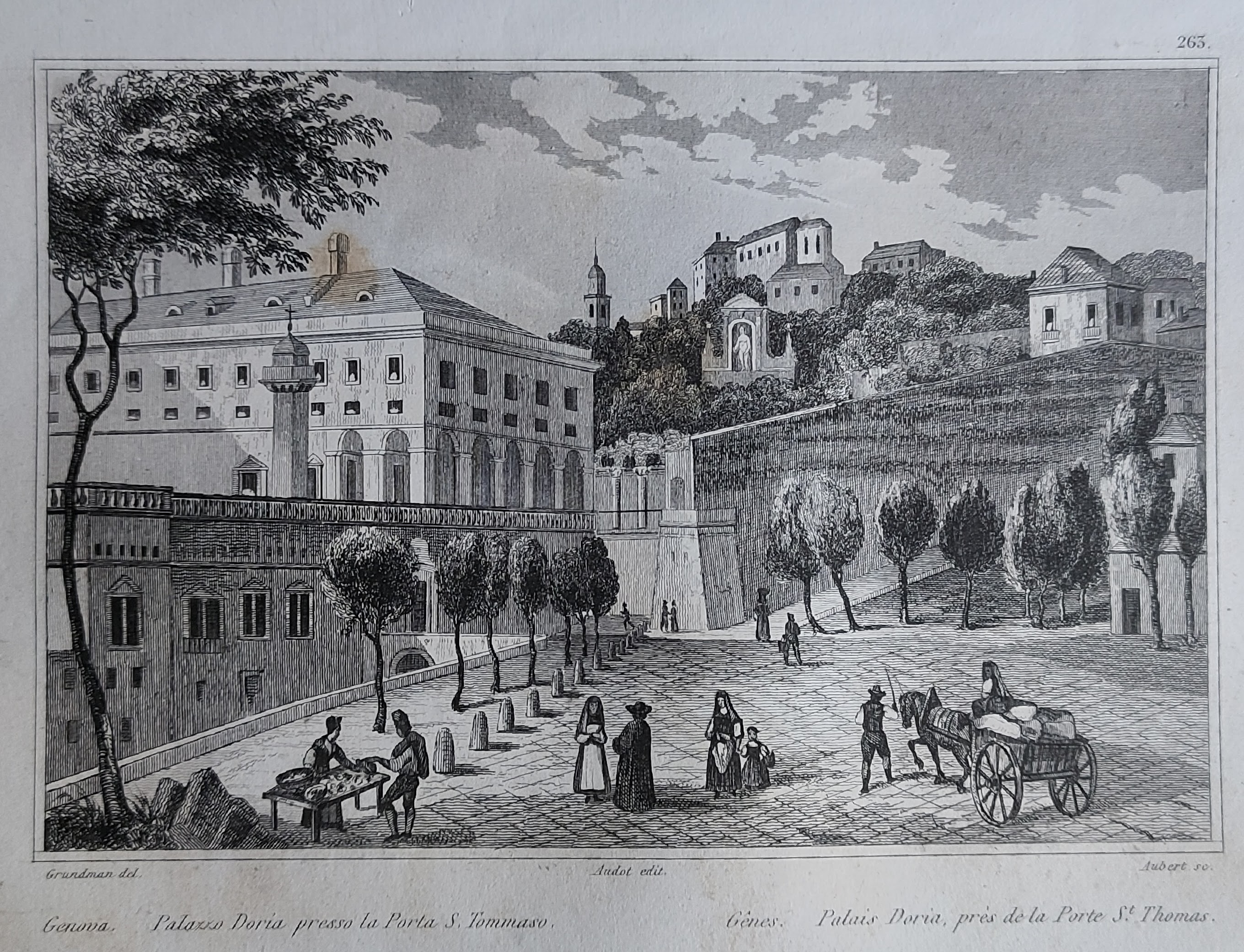
Map title
Palazzo Doria presso la porta di S.Tommaso
Author
Audot
Location shown in map
Genoa
Edition date
1835
Edition place
Turin
Editor
Pomba
Atlas
L'Italia, la Sicilia, le isole Eolie, l'isola d'Elba, la Sardegna, Malta, l'isola di Calipso
Price
20 Euro
State
[mint/EXCELLENT/very good/good/fair/mediocre/poor]
Color
Black/white
Verso
Blank
Size
Plate: cm (16 x 12) inches (6.3 x 4.72) Paper: cm (25 x 17) inches (9.84 x 6.69)
Technique
Steel engraving
Note
Reference
Wiki
Here for more info
In stock
Available
Info
info@thetreasuremaps.com
Code
#1116
×
![Palazzo Doria presso la porta di S.Tommaso by Audot, Genoa, 1835]()
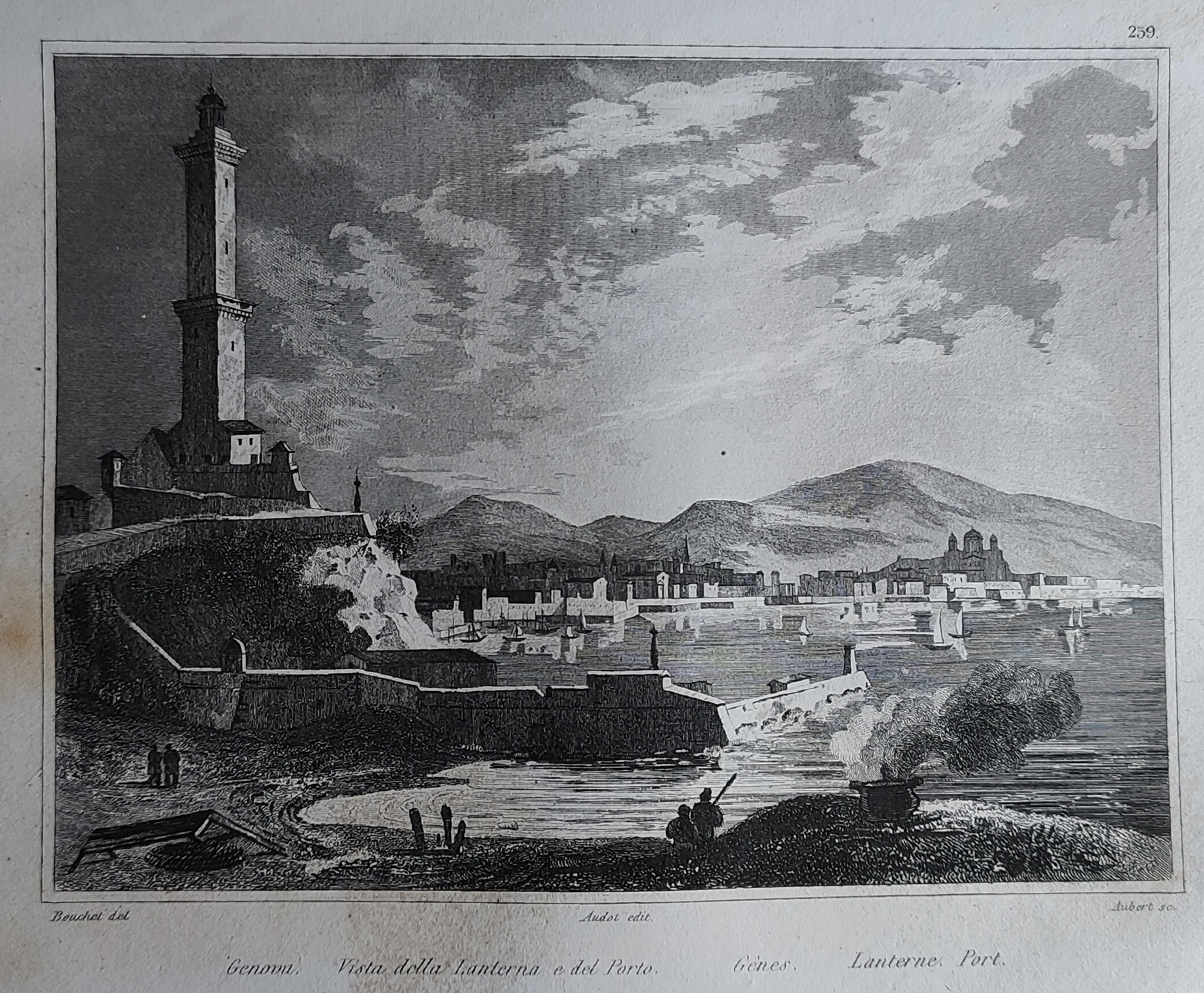
Map title
Vista della lanterna e del porto
Author
Audot
Location shown in map
Genoa
Edition date
1835
Edition place
Turin
Editor
Pomba
Atlas
L'Italia, la Sicilia, le isole Eolie, l'isola d'Elba, la Sardegna, Malta, l'isola di Calipso
Price
20 Euro
State
[mint/EXCELLENT/very good/good/fair/mediocre/poor]
Color
Black/white
Verso
Blank
Size
Plate: cm (16 x 12) inches (6.3 x 4.72) Paper: cm (25 x 17) inches (9.84 x 6.69)
Technique
Steel engraving
Note
Reference
Wiki
Here for more info
In stock
Available
Info
info@thetreasuremaps.com
Code
#1117
×
![Vista della lanterna e del porto by Audot, Genoa, 1835]()
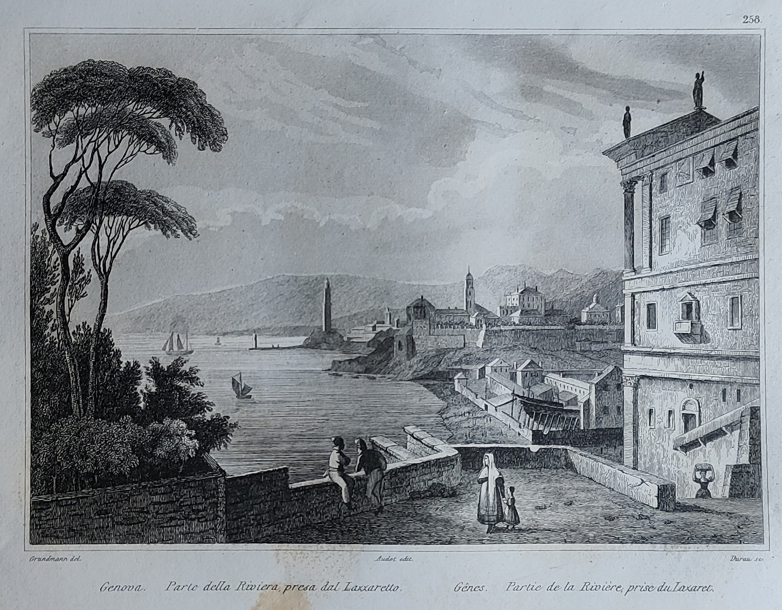
Map title
Parte della riviera presa dal lazzaretto
Author
Audot
Location shown in map
Genoa
Edition date
1835
Edition place
Turin
Editor
Pomba
Atlas
L'Italia, la Sicilia, le isole Eolie, l'isola d'Elba, la Sardegna, Malta, l'isola di Calipso
Price
20 Euro
State
[mint/EXCELLENT/very good/good/fair/mediocre/poor]
Color
Black/white
Verso
Blank
Size
Plate: cm (16 x 12) inches (6.3 x 4.72) Paper: cm (25 x 17) inches (9.84 x 6.69)
Technique
Steel engraving
Note
Reference
Wiki
Here for more info
In stock
Available
Info
info@thetreasuremaps.com
Code
#1118
×
![Parte della riviera presa dal lazzaretto by Audot, Genoa, 1835]()
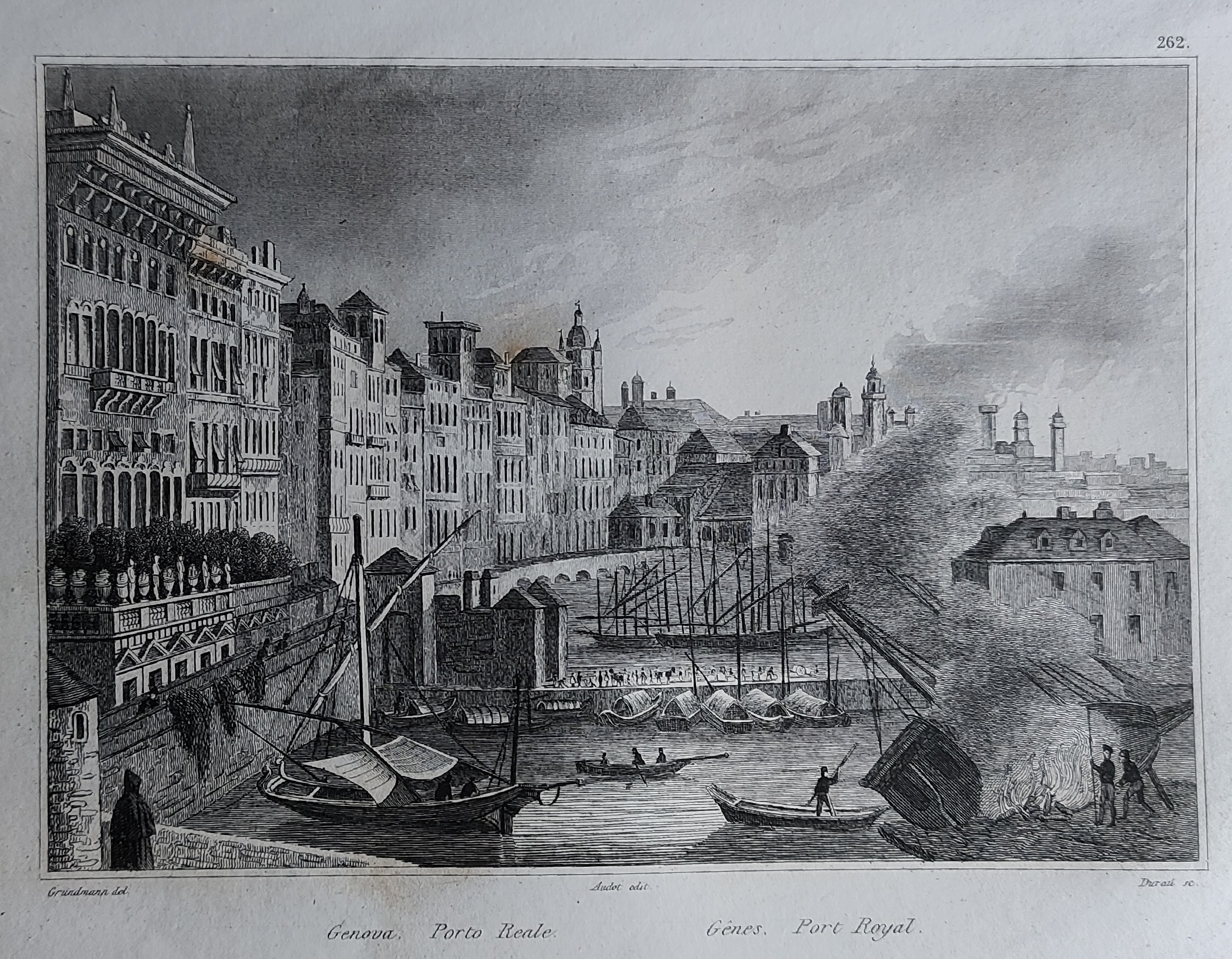
Map title
Porto Reale
Author
Audot
Location shown in map
Genoa
Edition date
1835
Edition place
Turin
Editor
Pomba
Atlas
L'Italia, la Sicilia, le isole Eolie, l'isola d'Elba, la Sardegna, Malta, l'isola di Calipso
Price
20 Euro
State
[mint/EXCELLENT/very good/good/fair/mediocre/poor]
Color
Black/white
Verso
Blank
Size
Plate: cm (16 x 12) inches (6.3 x 4.72) Paper: cm (25 x 17) inches (9.84 x 6.69)
Technique
Steel engraving
Note
Reference
Wiki
Here for more info
In stock
Available
Info
info@thetreasuremaps.com
Code
#1122
×
![Porto Reale by Audot, Genoa, 1835]()