News

Map title
None
Author
Luther
Location shown in map
Globe
Edition date
Circa 1925
Edition place
Berlin
Editor
Columbus
Atlas
Price
400 Euro
State
[mint/EXCELLENT/very good/good/fair/mediocre/poor]
Color
Old colors
Verso
Blank
Size
Plate: cm (0 x 0) inches (0 x 0) Paper: cm (20 x 20) inches (7.87 x 7.87)
Technique
Note
Reference
Wiki
Here for more info
In stock
Available
Info
info@thetreasuremaps.com
Code
#1064
×
![None by Luther, Globe, Circa 1925]()
Map title
Australia e Polinesia
Author
Stieler
Location shown in map
Oceania
Edition date
Circa 1870
Edition place
Gotha
Editor
Stieler
Atlas
Atlante scolastico Stieler
Price
50 Euro
State
[mint/excellent/very good/good/fair/mediocre/POOR]
Color
Old color
Verso
Blank
Size
Plate: cm (25 x 20) inches (9.84 x 7.87) Paper: cm (30 x 24) inches (11.81 x 9.45)
Technique
Steel engraving
Note
Reference
Wiki
Here for more info
In stock
Available
Info
info@thetreasuremaps.com
Code
#1065
×
![Australia e Polinesia by Stieler, Oceania, Circa 1870]()
Map title
Comitato di resistenza interna
Author
Location shown in map
Italy
Edition date
1917
Edition place
Rome
Editor
Atlas
Price
50 Euro
State
[mint/EXCELLENT/very good/good/fair/mediocre/poor]
Color
Black/white
Verso
Blank
Size
Plate: cm (9 x 14) inches (3.54 x 5.51) Paper: cm (9 x 14) inches (3.54 x 5.51)
Technique
Steel engraving
Note
Reference
Wiki
Here for more info
In stock
Available
Info
info@thetreasuremaps.com
Code
#1066
×
![Comitato di resistenza interna by , Italy, 1917]()
Map title
L'Italie divisee en ses different ...
Author
Janvier
Location shown in map
Italy
Edition date
1780
Edition place
Venice
Editor
Santini
Atlas
Atlas Universel
Price
350 Euro
State
[mint/excellent/VERY GOOD/good/fair/mediocre/poor]
Color
Old colors
Verso
Blank
Size
Plate: cm (64 x 48) inches (25.2 x 18.9) Paper: cm (72 x 55) inches (28.35 x 21.65)
Technique
Copper engraving
Note
Reference
R.Borri L'Italia nelle antiche carte pag.255
Wiki
Here for more info
In stock
Available
Info
info@thetreasuremaps.com
Code
#1017
×
![L'Italie divisee en ses different ... by Janvier, Italy, 1780]()
Map title
Plan du port de Genes
Author
Darondaut
Location shown in map
Genoa
Edition date
1883
Edition place
Paris
Editor
Atlas
Price
400 Euro
State
[mint/EXCELLENT/very good/good/fair/mediocre/poor]
Color
Old color.
Verso
Blank
Size
Plate: cm (91 x 62) inches (35.83 x 24.41) Paper: cm (96 x 66) inches (37.8 x 25.98)
Technique
Steel engraving
Note
Reference
--
Wiki
Here for more info
In stock
Available
Info
info@thetreasuremaps.com
Code
#1018
×
![Plan du port de Genes by Darondaut, Genoa, 1883]()
Map title
L'Italie divisee en ses different ...
Author
Janvier
Location shown in map
Italy
Edition date
1780
Edition place
Venice
Editor
Santini
Atlas
Atlas Universel
Price
350 Euro
State
[mint/excellent/VERY GOOD/good/fair/mediocre/poor]
Color
Old colors
Verso
Blank
Size
Plate: cm (64 x 48) inches (25.2 x 18.9) Paper: cm (72 x 55) inches (28.35 x 21.65)
Technique
Copper engraving
Note
Reference
R.Borri L'Italia nelle antiche carte pag.255
Wiki
Here for more info
In stock
Available
Info
info@thetreasuremaps.com
Code
#1057
×
![L'Italie divisee en ses different ... by Janvier, Italy, 1780]()
Map title
Mappe-monde
Author
Janvier
Location shown in map
World
Edition date
1782
Edition place
Paris
Editor
Lattre
Atlas
Price
400 Euro
State
[mint/excellent/VERY GOOD/good/fair/mediocre/poor]
Color
Old colors
Verso
Blank
Size
Plate: cm (45 x 31) inches (17.72 x 12.2) Paper: cm (47 x 35) inches (18.5 x 13.78)
Technique
Copper engraving
Note
Reference
Wiki
Here for more info
In stock
Available
Info
info@thetreasuremaps.com
Code
#1159
×
![Mappe-monde by Janvier, World, 1782]()
Map title
L'Italie divisee ...
Author
Louise Brion De La Tour
Location shown in map
Italy
Edition date
1766
Edition place
Paris
Editor
Atlas
Atlas General
Price
300 Euro
State
[mint/EXCELLENT/very good/good/fair/mediocre/poor]
Color
Old colors
Verso
Blank
Size
Plate: cm (53 x 37) inches (20.87 x 14.57) Paper: cm (55 x 39) inches (21.65 x 15.35)
Technique
Copper engraving
Note
Reference
R.Borri L'Italia nelle antiche carte pag.257
Wiki
Here for more info
In stock
Available
Info
info@thetreasuremaps.com
Code
#1013
×
![L'Italie divisee ... by Louise Brion De La Tour, Italy, 1766]()
Map title
Italien
Author
Mollo
Location shown in map
Italy
Edition date
Circa 1824
Edition place
Wien
Editor
Atlas
Price
125 Euro
State
[mint/EXCELLENT/very good/good/fair/mediocre/poor]
Color
Old colors
Verso
Blank
Size
Plate: cm (32 x 45) inches (12.6 x 17.72) Paper: cm (38 x 47) inches (14.96 x 18.5)
Technique
Steel engraving
Note
Reference
Wiki
Here for more info
In stock
Available
Info
info@thetreasuremaps.com
Code
#1015
×
![Italien by Mollo, Italy, Circa 1824]()
Map title
Italien
Author
Streit
Location shown in map
Italy
Edition date
Circa 1836
Edition place
Berlin
Editor
Atlas
Price
75 Euro
State
[mint/EXCELLENT/very good/good/fair/mediocre/poor]
Color
Old colors
Verso
Blank
Size
Plate: cm (25 x 30) inches (9.84 x 11.81) Paper: cm (26 x 32) inches (10.24 x 12.6)
Technique
Steel engraving
Note
Reference
Wiki
Here for more info
In stock
Available
Info
info@thetreasuremaps.com
Code
#1016
×
![Italien by Streit, Italy, Circa 1836]()
Map title
Asie
Author
Monin
Location shown in map
Asia
Edition date
1840
Edition place
Paris
Editor
Atlas
Atlas Classique de la Geographie
Price
75 Euro
State
[mint/EXCELLENT/very good/good/fair/mediocre/poor]
Color
Old colors
Verso
Blank
Size
Plate: cm (35 x 28) inches (13.78 x 11.02) Paper: cm (45 x 33) inches (17.72 x 12.99)
Technique
Copper engraving
Note
Reference
Wiki
Here for more info
In stock
Available
Info
info@thetreasuremaps.com
Code
#1009
×
![Asie by Monin, Asia, 1840]()
Map title
Iles Britannique
Author
Monin
Location shown in map
British Isles
Edition date
1840
Edition place
Paris
Editor
Atlas
Atlas Classique de la Geographie
Price
75 Euro
State
[mint/EXCELLENT/very good/good/fair/mediocre/poor]
Color
Old colors
Verso
Blank
Size
Plate: cm (28 x 37) inches (11.02 x 14.57) Paper: cm (33 x 45) inches (12.99 x 17.72)
Technique
Copper engraving
Note
Reference
Wiki
Here for more info
In stock
Available
Info
info@thetreasuremaps.com
Code
#1010
×
![Iles Britannique by Monin, British Isles, 1840]()
Map title
Amerique Meridionale
Author
Monin
Location shown in map
South America
Edition date
1840
Edition place
Paris
Editor
Atlas
Atlas Classique de la Geographie
Price
50 Euro
State
[mint/EXCELLENT/very good/good/fair/mediocre/poor]
Color
Old colors
Verso
Blank
Size
Plate: cm (27 x 37) inches (10.63 x 14.57) Paper: cm (33 x 45) inches (12.99 x 17.72)
Technique
Copper engraving
Note
Reference
Wiki
Here for more info
In stock
Available
Info
info@thetreasuremaps.com
Code
#1011
×
![Amerique Meridionale by Monin, South America, 1840]()
Map title
Siberie
Author
Monin
Location shown in map
Siberia
Edition date
1840
Edition place
Paris
Editor
Atlas
Atlas Classique de la Geographie
Price
75 Euro
State
[mint/EXCELLENT/very good/good/fair/mediocre/poor]
Color
Old colors
Verso
Blank
Size
Plate: cm (39 x 28) inches (15.35 x 11.02) Paper: cm (45 x 33) inches (17.72 x 12.99)
Technique
Copper engraving
Note
Reference
Wiki
Here for more info
In stock
Available
Info
info@thetreasuremaps.com
Code
#1012
×
![Siberie by Monin, Siberia, 1840]()
Map title
Grece Ancienne
Author
Monin
Location shown in map
Greece
Edition date
1840
Edition place
Paris
Editor
Atlas
Atlas Classique de la Geographie
Price
50 Euro
State
[mint/EXCELLENT/very good/good/fair/mediocre/poor]
Color
Old colors
Verso
Blank
Size
Plate: cm (27 x 37) inches (10.63 x 14.57) Paper: cm (33 x 45) inches (12.99 x 17.72)
Technique
Copper engraving
Note
Reference
Wiki
Here for more info
In stock
Available
Info
info@thetreasuremaps.com
Code
#1014
×
![Grece Ancienne by Monin, Greece, 1840]()
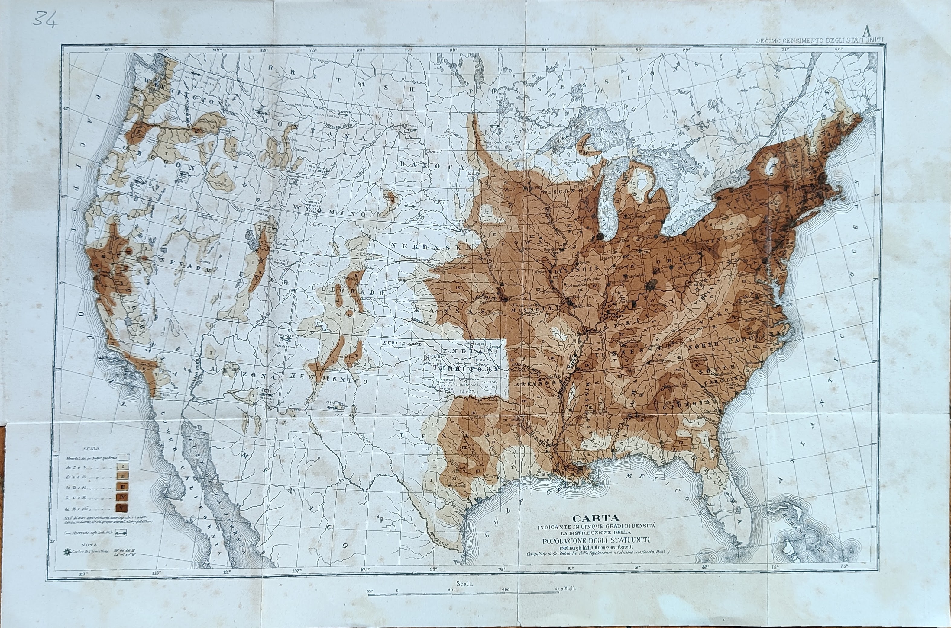
Map title
Carta indicante in cinque gradi di intensita la distribuzione ...
Author
Location shown in map
USA
Edition date
Circa 1880
Edition place
Editor
Atlas
Price
50 Euro
State
[mint/EXCELLENT/very good/good/fair/mediocre/poor]
Color
Old colors
Verso
Blank
Size
Plate: cm (41 x 26) inches (16.14 x 10.24) Paper: cm (46 x 32) inches (18.11 x 12.6)
Technique
Steel engraving
Note
Reference
Wiki
Here for more info
In stock
Available
Info
info@thetreasuremaps.com
Code
#1028
×
![Carta indicante in cinque gradi di intensita la distribuzione ... by , USA, Circa 1880]()
Map title
Carta indicante le concessioni di terreni ...
Author
Location shown in map
USA
Edition date
Circa 1880
Edition place
Editor
Atlas
Price
50 Euro
State
[mint/EXCELLENT/very good/good/fair/mediocre/poor]
Color
Old colors
Verso
Blank
Size
Plate: cm (41 x 26) inches (16.14 x 10.24) Paper: cm (46 x 32) inches (18.11 x 12.6)
Technique
Steel engraving
Note
Reference
Wiki
Here for more info
In stock
Available
Info
info@thetreasuremaps.com
Code
#1029
×
![Carta indicante le concessioni di terreni ... by , USA, Circa 1880]()
Map title
Carta indicante in cinque gradi di densita ...
Author
Location shown in map
USA
Edition date
Circa 1880
Edition place
Editor
Atlas
Price
50 Euro
State
[mint/EXCELLENT/very good/good/fair/mediocre/poor]
Color
Old colors
Verso
Blank
Size
Plate: cm (17 x 24) inches (6.69 x 9.45) Paper: cm (22 x 30) inches (8.66 x 11.81)
Technique
Steel engraving
Note
Reference
Wiki
Here for more info
In stock
Available
Info
info@thetreasuremaps.com
Code
#1030
×
![Carta indicante in cinque gradi di densita ... by , USA, Circa 1880]()
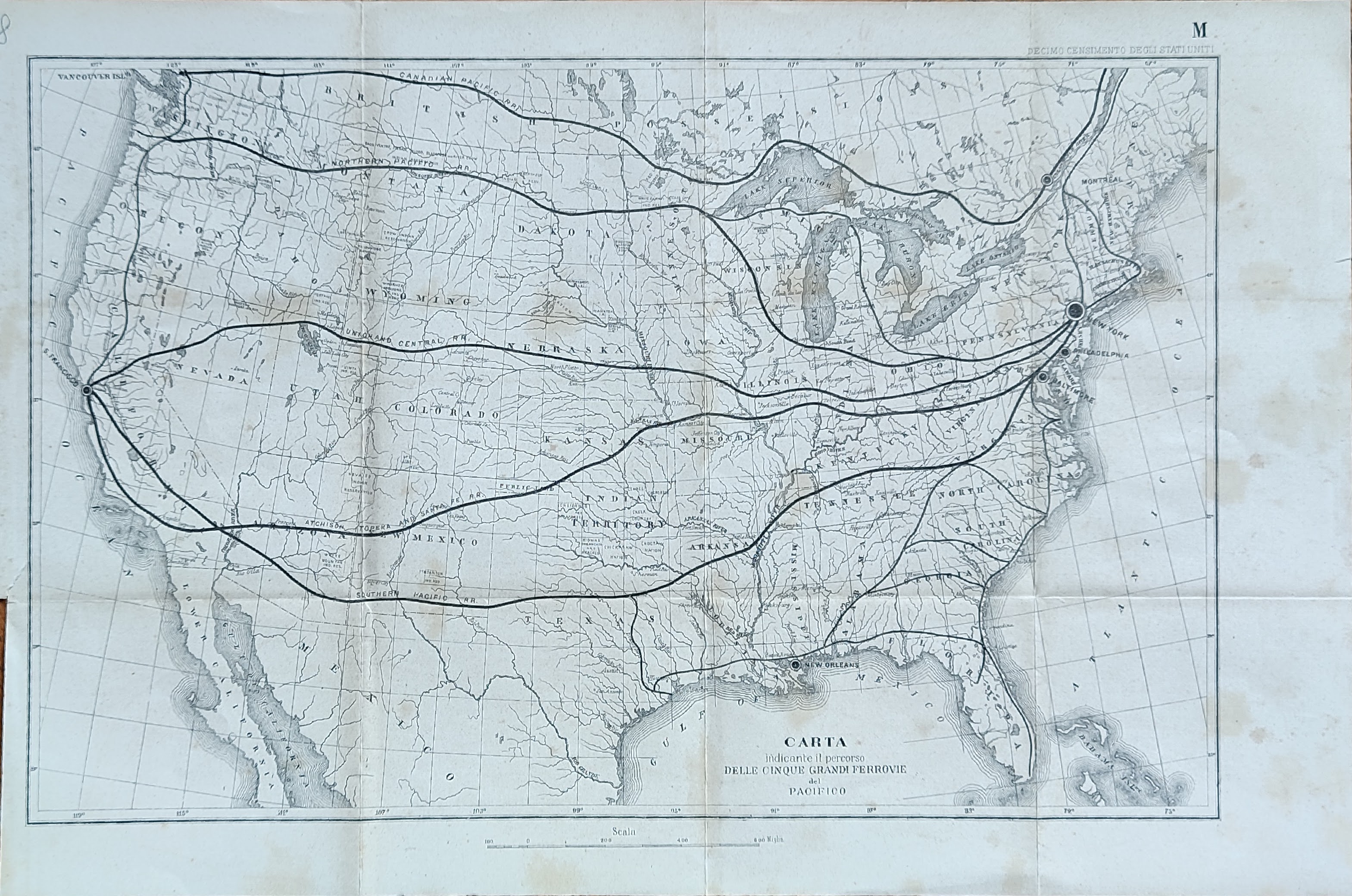
Map title
Carta indicante il percorso delle cinque ...
Author
Location shown in map
USA
Edition date
Circa 1880
Edition place
Editor
Atlas
Price
50 Euro
State
[mint/EXCELLENT/very good/good/fair/mediocre/poor]
Color
Old colors
Verso
Blank
Size
Plate: cm (41 x 26) inches (16.14 x 10.24) Paper: cm (46 x 32) inches (18.11 x 12.6)
Technique
Steel engraving
Note
Reference
Wiki
Here for more info
In stock
Available
Info
info@thetreasuremaps.com
Code
#1031
×
![Carta indicante il percorso delle cinque ... by , USA, Circa 1880]()
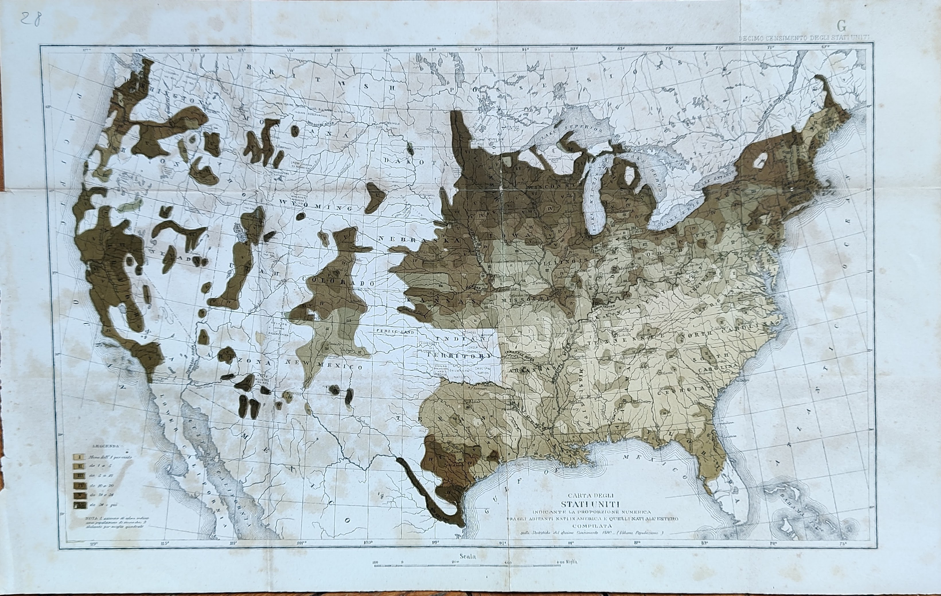
Map title
Carta indicante la proporzione numerica ...
Author
Location shown in map
USA
Edition date
Circa 1880
Edition place
Editor
Atlas
Price
50 Euro
State
[mint/EXCELLENT/very good/good/fair/mediocre/poor]
Color
Old colors
Verso
Blank
Size
Plate: cm (41 x 26) inches (16.14 x 10.24) Paper: cm (46 x 32) inches (18.11 x 12.6)
Technique
Steel engraving
Note
Reference
Wiki
Here for more info
In stock
Available
Info
info@thetreasuremaps.com
Code
#1032
×
![Carta indicante la proporzione numerica ... by , USA, Circa 1880]()