News
Map title
China: Peking und der norden
Author
Location shown in map
North China
Edition date
Circa 1970
Edition place
Editor
Atlas
Price
75 Euro
State
[mint/EXCELLENT/very good/good/fair/mediocre/poor]
Color
Color
Verso
Blank
Size
Plate: cm (58 x 84) inches (22.83 x 33.07) Paper: cm (58 x 84) inches (22.83 x 33.07)
Technique
Steel engraving
Note
Reference
Wiki
Here for more info
In stock
Available
Info
info@thetreasuremaps.com
Code
#1371
×
![China: Peking und der norden by , North China, Circa 1970]()
Map title
Estados-Unidos
Author
Gaspar
Location shown in map
USA
Edition date
1855
Edition place
Madrid
Editor
Atlas
Price
50 Euro
State
[mint/EXCELLENT/very good/good/fair/mediocre/poor]
Color
Old colors
Verso
Blank
Size
Plate: cm (29 x 21) inches (11.42 x 8.27) Paper: cm (29 x 21) inches (11.42 x 8.27)
Technique
Steel engraving
Note
Reference
Wiki
Here for more info
In stock
Available
Info
info@thetreasuremaps.com
Code
#1364
×
![Estados-Unidos by Gaspar, USA, 1855]()

Map title
Le reseau del cables francais
Author
Location shown in map
South Europe
Edition date
1932
Edition place
Paris
Editor
Atlas
Price
50 Euro
State
[mint/EXCELLENT/very good/good/fair/mediocre/poor]
Color
Black/white
Verso
Blank
Size
Plate: cm (37 x 27) inches (14.57 x 10.63) Paper: cm (37 x 27) inches (14.57 x 10.63)
Technique
Steel engraving
Note
Reference
Wiki
Here for more info
In stock
Available
Info
info@thetreasuremaps.com
Code
#1365
×
![Le reseau del cables francais by , South Europe, 1932]()
Map title
Mondkarte
Author
Meyers
Location shown in map
Moon
Edition date
Circa 1895
Edition place
Lepzing
Editor
Bibliographic Institute
Atlas
Price
50 Euro
State
[mint/EXCELLENT/very good/good/fair/mediocre/poor]
Color
Old colors
Verso
Blank
Size
Plate: cm (27 x 22) inches (10.63 x 8.66) Paper: cm (31 x 24) inches (12.2 x 9.45)
Technique
Steel engraving
Note
Reference
Wiki
Here for more info
In stock
Available
Info
info@thetreasuremaps.com
Code
#1368
×
![Mondkarte by Meyers, Moon, Circa 1895]()
Map title
Piemonte
Author
Nicouline
Location shown in map
Piemont
Edition date
Circa 1951
Edition place
Milan
Editor
Atlas
Price
20 Euro
State
[mint/EXCELLENT/very good/good/fair/mediocre/poor]
Color
Old colors
Verso
Blank
Size
Plate: cm (24 x 30) inches (9.45 x 11.81) Paper: cm (24 x 30) inches (9.45 x 11.81)
Technique
Steel engraving
Note
Reference
Wiki
Here for more info
In stock
Available
Info
info@thetreasuremaps.com
Code
#1369
×
![Piemonte by Nicouline, Piemont, Circa 1951]()
Map title
La Calabria vista da Roma
Author
Gravina
Location shown in map
Italy
Edition date
1986
Edition place
Matera
Editor
Ambrico
Atlas
Price
100 Euro
State
[mint/EXCELLENT/very good/good/fair/mediocre/poor]
Color
Color
Verso
Blank
Size
Plate: cm (86 x 62) inches (33.86 x 24.41) Paper: cm (86 x 62) inches (33.86 x 24.41)
Technique
Steel engraving
Note
Reference
Wiki
Here for more info
In stock
Available
Info
info@thetreasuremaps.com
Code
#1372
×
![La Calabria vista da Roma by Gravina, Italy, 1986]()
Map title
Northern Hemisphere
Author
Location shown in map
North pole
Edition date
1946
Edition place
Washington
Editor
National geographic society
Atlas
Price
100 Euro
State
[mint/EXCELLENT/very good/good/fair/mediocre/poor]
Color
Old colors
Verso
Blank
Size
Plate: cm (55 x 60) inches (21.65 x 23.62) Paper: cm (55 x 60) inches (21.65 x 23.62)
Technique
Steel engraving
Note
Reference
Wiki
Here for more info
In stock
Available
Info
info@thetreasuremaps.com
Code
#1377
×
![Northern Hemisphere by , North pole, 1946]()
Map title
Aquila citta' nel Abruzzo
Author
Scoto
Location shown in map
Aquila
Edition date
Circa 1650
Edition place
Editor
Atlas
Itinerario overo nova descrittione de' viaggi principali d'Italia
Price
50 Euro
State
[mint/excellent/very good/good/fair/mediocre/POOR
Color
Black/white
Verso
Blank
Size
Plate: cm (14 x 8) inches (5.51 x 3.15) Paper: cm (14 x 8) inches (5.51 x 3.15)
Technique
Copper engraving
Note
Reference
Wiki
Here for more info
In stock
Available
Info
info@thetreasuremaps.com
Code
#1376
×
![Aquila citta' nel Abruzzo by Scoto, Aquila, Circa 1650]()
Map title
Isles de la Reine Charlotte
Author
Bonne
Location shown in map
Canada
Edition date
1776
Edition place
Paris
Editor
Lattre
Atlas
Atlas Moderne
Price
100 Euro
State
[mint/EXCELLENT/very good/good/fair/mediocre/poor]
Color
Black/white
Verso
Blank
Size
Plate: cm (35 x 24) inches (13.78 x 9.45) Paper: cm (41 x 28) inches (16.14 x 11.02)
Technique
Copper engraving
Note
Reference
--
Wiki
Here for more info
In stock
Available
Info
info@thetreasuremaps.com
Code
#1375
×
![Isles de la Reine Charlotte by Bonne, Canada, 1776]()
Map title
Oceanie
Author
Location shown in map
Oceania
Edition date
Circa 1860
Edition place
Paris
Editor
Poussielgue
Atlas
Price
50 Euro
State
[mint/EXCELLENT/very good/good/fair/mediocre/poor]
Color
Old colors
Verso
Blank
Size
Plate: cm (27 x 34) inches (10.63 x 13.39) Paper: cm (31 x 44) inches (12.2 x 17.32)
Technique
Steel engraving
Note
Reference
Wiki
Here for more info
In stock
Available
Info
info@thetreasuremaps.com
Code
#1374
×
![Oceanie by , Oceania, Circa 1860]()
Map title
A traveler's map of Itay
Author
Dorr
Location shown in map
Italy
Edition date
1980
Edition place
Washington
Editor
National geographic society
Atlas
Price
50 Euro
State
[mint/EXCELLENT/very good/good/fair/mediocre/poor]
Color
Color
Verso
Blank
Size
Plate: cm (54 x 27) inches (21.26 x 10.63) Paper: cm (54 x 27) inches (21.26 x 10.63)
Technique
Steel engraving
Note
Turistic map
Reference
Wiki
Here for more info
In stock
Available
Info
info@thetreasuremaps.com
Code
#1370
×
![A traveler's map of Itay by Dorr, Italy, 1980]()
Map title
L'Italie dressee sur les Observations
Author
De L'Isle
Location shown in map
Italy
Edition date
Circa 1720
Edition place
Amsterdam
Editor
Mortier
Atlas
Atlas de Geographie
Price
300 Euro
State
[mint/EXCELLENT/very good/good/fair/mediocre/poor]
Color
Old colors
Verso
Blank
Size
Plate: cm (60 x 49) inches (23.62 x 19.29) Paper: cm (66 x 52) inches (25.98 x 20.47)
Technique
Copper engraving
Note
Reference
R.Borri L'Italia nelle antiche carte pag.214
Wiki
Here for more info
In stock
Available
Info
info@thetreasuremaps.com
Code
#1357
×
![L'Italie dressee sur les Observations by De L'Isle, Italy, Circa 1720]()
Map title
Viaggio da Napoli a Otranto
Author
Vallardi
Location shown in map
South Italy
Edition date
Circa 1820
Edition place
Editor
--
Atlas
Itinéraire d'Italie ou la description des voyages
Price
100 Euro
State
[mint/excellent/VERY GOOD/good/fair/mediocre/poor]
Color
Black/white
Verso
Blank
Size
Plate: cm (47 x 15) inches (18.5 x 5.91) Paper: cm (49 x 18) inches (19.29 x 7.09)
Technique
Copper engraving
Note
Reference
Wiki
Here for more info
In stock
Available
Info
info@thetreasuremaps.com
Code
#1352
×
![Viaggio da Napoli a Otranto by Vallardi, South Italy, Circa 1820]()
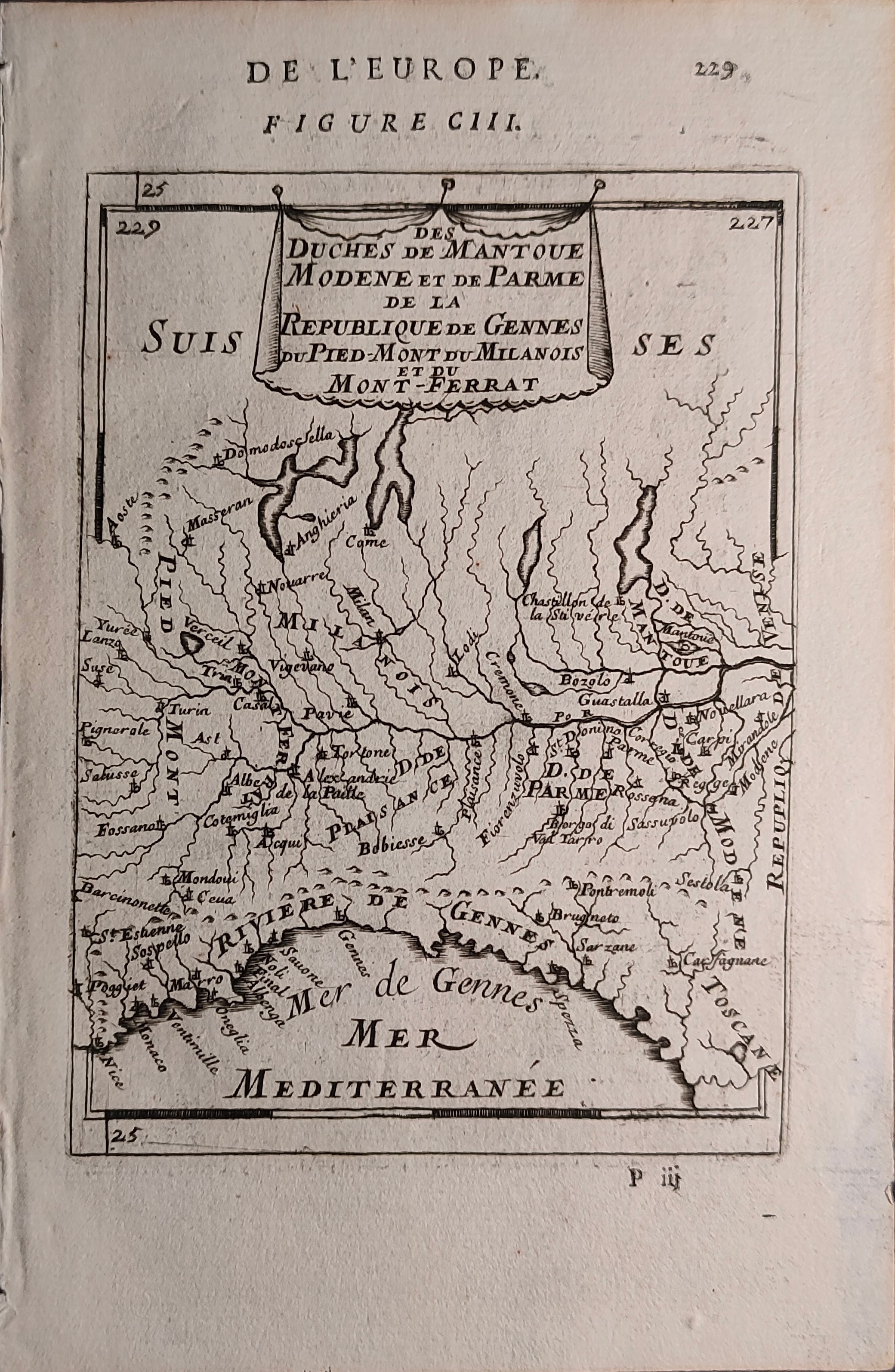
Map title
Des Duches De Mantoue Modene et de Parme, De La Republique de Gennes Du Pied-Mont du Milanois et du Mont- Ferrat
Author
Mallet
Location shown in map
Liguria
Edition date
1683
Edition place
Paris
Editor
--
Atlas
Description de l'univers - Chez Denis Thierry
Price
75 Euro
State
[mint/EXCELLENT/very good/good/fair/mediocre/poor]
Color
Black/white
Verso
French text pag 24
Size
Plate: cm (11 x 15) inches (4.33 x 5.91) Paper: cm (14 x 21) inches (5.51 x 8.27)
Technique
Copper engraving
Note
Reference
--
Wiki
Here for more info
In stock
Available
Info
info@thetreasuremaps.com
Code
#1353
×
![Des Duches De Mantoue Modene et de Parme, De La Republique de Gennes Du Pied-Mont du Milanois et du Mont- Ferrat by Mallet, Liguria, 1683]()
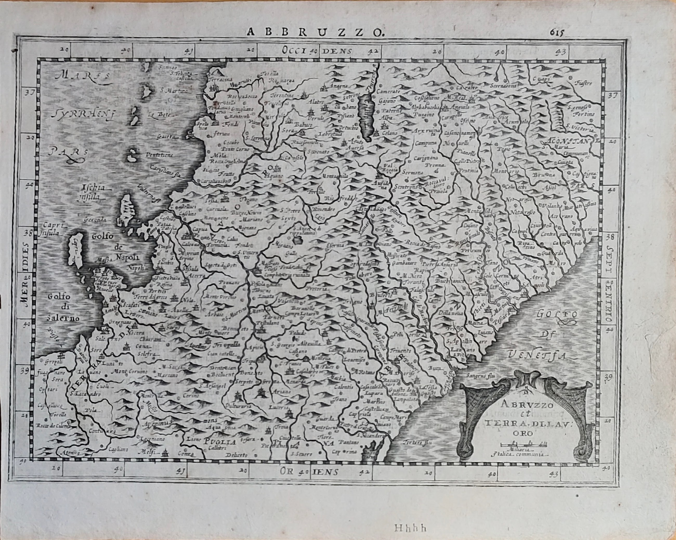
Map title
Abbruzzo
Author
Mercator
Location shown in map
Abruzzo
Edition date
1632
Edition place
Amsterdam
Editor
Houndius
Atlas
Altas de novo plurimis in locis
Price
200 Euro
State
[mint/EXCELLENT/very good/good/fair/mediocre/poor]
Color
Black/white
Verso
Latin text 616
Size
Plate: cm (25 x 19) inches (9.84 x 7.48) Paper: cm (28 x 22) inches (11.02 x 8.66)
Technique
Copper engraving
Note
Reference
Ex ipso Atlante
Wiki
Here for more info
In stock
Available
Info
info@thetreasuremaps.com
Code
#1354
×
![Abbruzzo by Mercator, Abruzzo, 1632]()
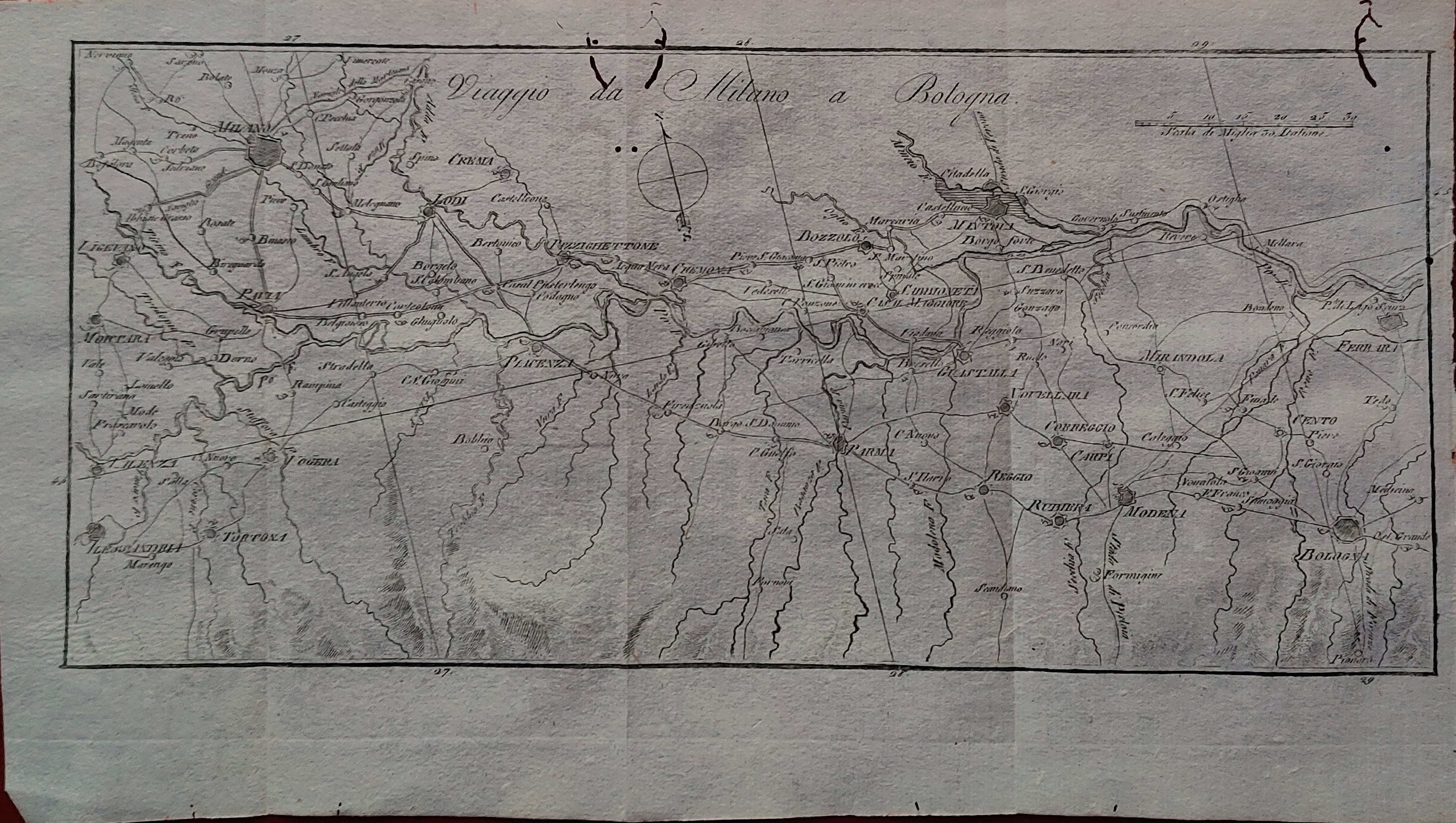
Map title
Viaggio da Milano a Bologna
Author
Vallardi
Location shown in map
North Italy
Edition date
Circa 1820
Edition place
Editor
--
Atlas
Itinéraire d'Italie ou la description des voyages
Price
100 Euro
State
[mint/excellent/VERY GOOD/good/fair/mediocre/poor]
Color
Black/white
Verso
Blank
Size
Plate: cm (30 x 14) inches (11.81 x 5.51) Paper: cm (32 x 18) inches (12.6 x 7.09)
Technique
Copper engraving
Note
Reference
Wiki
Here for more info
In stock
Available
Info
info@thetreasuremaps.com
Code
#1351
×
![Viaggio da Milano a Bologna by Vallardi, North Italy, Circa 1820]()

Map title
Totius Italiae tabula
Author
Visscher
Location shown in map
Italy
Edition date
1664
Edition place
Amsterdam
Editor
Atlas
Atlas
Price
800 Euro
State
[mint/EXCELLENT/very good/good/fair/mediocre/poor]
Color
Old colors
Verso
Blank
Size
Plate: cm (56 x 45) inches (22.05 x 17.72) Paper: cm (59 x 47) inches (23.23 x 18.5)
Technique
Copper engraving
Note
Reference
R.Borri L'Italia nelle antiche carte pag.143
Wiki
Here for more info
In stock
Available
Info
info@thetreasuremaps.com
Code
#1348
×
![Totius Italiae tabula by Visscher, Italy, 1664]()

Map title
ITALIA Antica di Cl. Tolomeo
Author
Magini
Location shown in map
Italy
Edition date
1620
Edition place
Bologna
Editor
Atlas
Italia
Price
700 Euro
State
[mint/EXCELLENT/very good/good/fair/mediocre/poor]
Color
Black/white
Verso
Blank
Size
Plate: cm (48 x 34) inches (18.9 x 13.39) Paper: cm (55 x 41) inches (21.65 x 16.14)
Technique
Copper engraving
Note
Reference
R.Borri L'Italia nelle antiche carte pag.36
Wiki
Here for more info
In stock
Available
Info
info@thetreasuremaps.com
Code
#1349
×
![ITALIA Antica di Cl. Tolomeo by Magini, Italy, 1620]()

Map title
Sumatra
Author
Munster
Location shown in map
Sumatra
Edition date
1598
Edition place
Basel
Editor
Henrich Petri
Atlas
Cosmographia Universalis
Price
300 Euro
State
[mint/excellent/VERY GOOD/good/fair/mediocre/poor]
Color
Black/white
Verso
German text
Size
Plate: cm (36 x 31) inches (14.17 x 12.2) Paper: cm (32 x 39) inches (12.6 x 15.35)
Technique
Woodcut
Note
Reference
--
Wiki
Here for more info
In stock
Available
Info
info@thetreasuremaps.com
Code
#1350
Sumatra
Author
Munster
Location shown in map
Sumatra
Edition date
1598
Edition place
Basel
Editor
Henrich Petri
Atlas
Cosmographia Universalis
Price
300 Euro
State
[mint/excellent/VERY GOOD/good/fair/mediocre/poor]
Color
Black/white
Verso
German text
Size
Plate: cm (36 x 31) inches (14.17 x 12.2) Paper: cm (32 x 39) inches (12.6 x 15.35)
Technique
Woodcut
Note
Reference
--
Wiki
Here for more info
In stock
Available
Info
info@thetreasuremaps.com
Code
#1350
×
![Sumatra by Munster, Sumatra, 1598]()
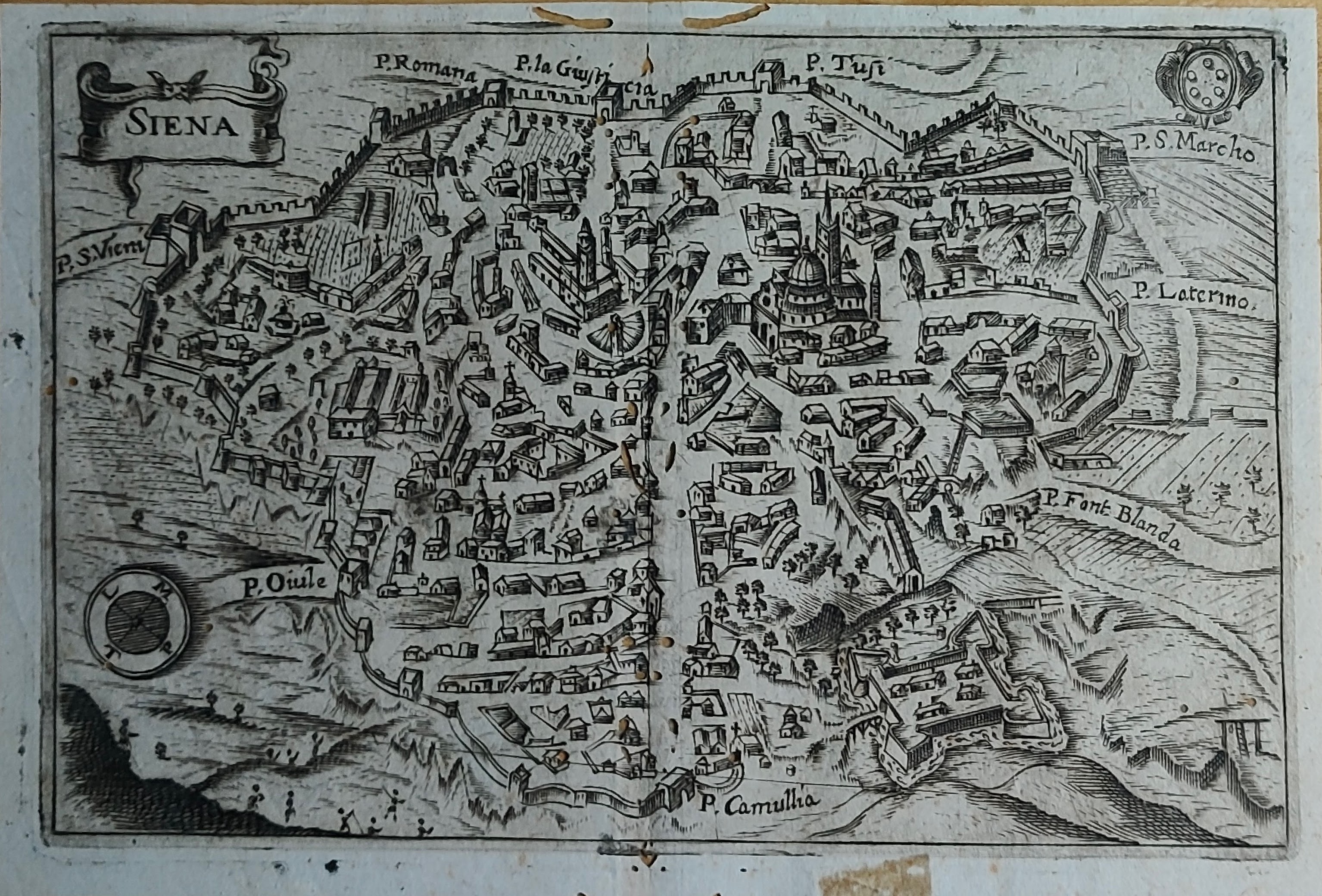
Map title
Siena
Author
Location shown in map
Siena
Edition date
Circa 1600
Edition place
Editor
Atlas
Price
150 Euro
State
[mint/excellent/VERY GOOD/good/fair/mediocre/poor]
Color
Black/white
Verso
Blank
Size
Plate: cm (17 x 11) inches (6.69 x 4.33) Paper: cm (18 x 12.3) inches (7.09 x 4.84)
Technique
Copper engraving
Note
Reference
Wiki
Here for more info
In stock
Available
Info
info@thetreasuremaps.com
Code
#1355
Siena
Author
Location shown in map
Siena
Edition date
Circa 1600
Edition place
Editor
Atlas
Price
150 Euro
State
[mint/excellent/VERY GOOD/good/fair/mediocre/poor]
Color
Black/white
Verso
Blank
Size
Plate: cm (17 x 11) inches (6.69 x 4.33) Paper: cm (18 x 12.3) inches (7.09 x 4.84)
Technique
Copper engraving
Note
Reference
Wiki
Here for more info
In stock
Available
Info
info@thetreasuremaps.com
Code
#1355
×
![Siena by , Siena, Circa 1600]()