News
Map title
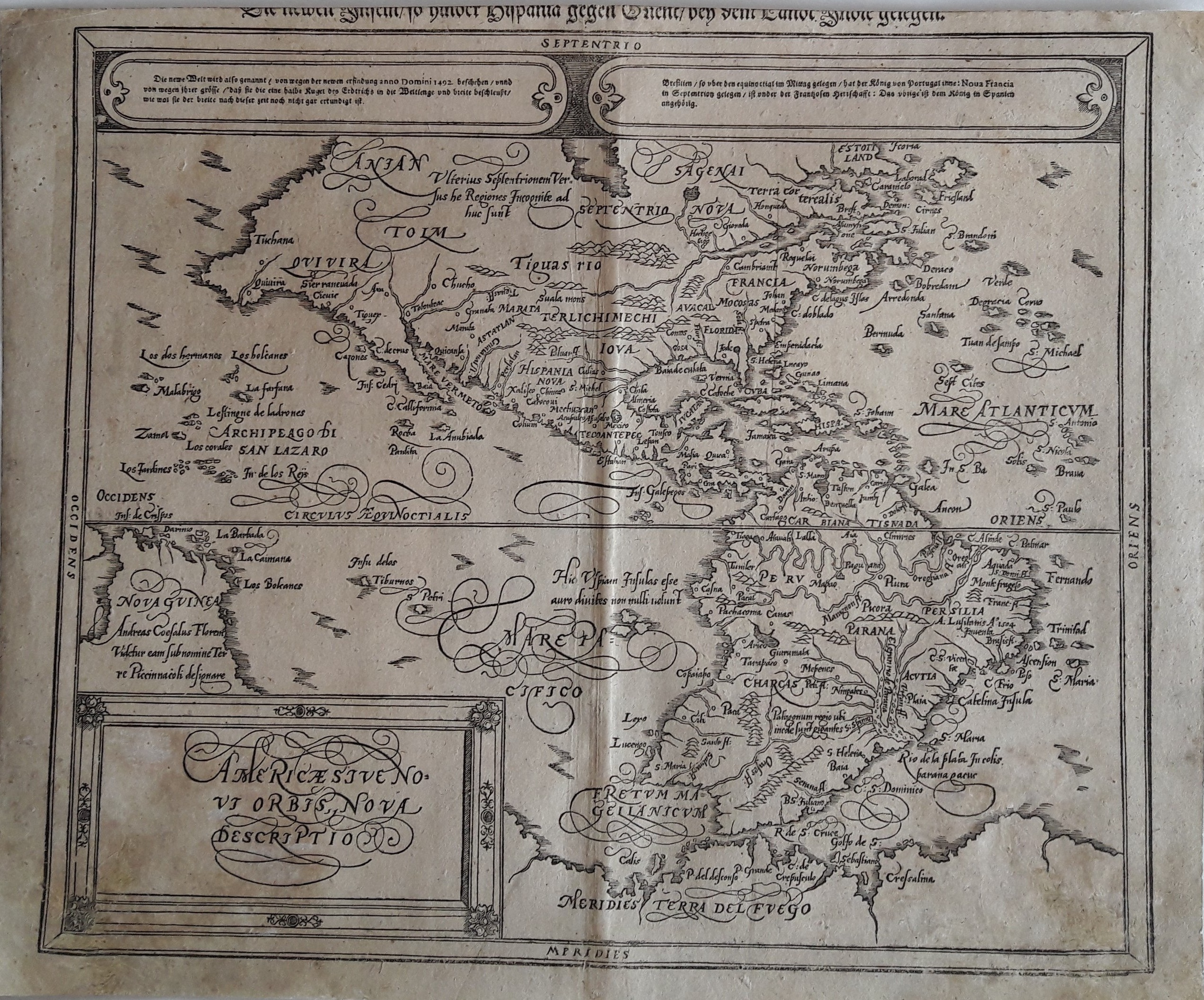
Americae sive novi Orbis, nova Descriptio
Author
Munster
Location shown in map
North and south America.
Edition date
1590
Edition place
--
Editor
Henrich Petri
Atlas
Cosmographia Universalis
Price
Please ask: info@thetreasuremaps.com
State
[mint/excellent/very good/good/FAIR/mediocre/poor] need to be restored
Color
Black/white
Verso
German text
Size
Plate: cm (34.3 x 30.5) inches (13.5 x 12.01) Paper: cm (39.4 x 33) inches (15.51 x 12.99)
Technique
Woodcut
Note
Influential wood cut map from Munsters Cosmographia, based on Ortelius 1570 map, with the bulge on the west coast of South America. This map replaced the highly speculative Munster map of 1540
Reference
--
Wiki
Here for more info
In stock
Available
Info
info@thetreasuremaps.com
Code
#0054
×
![Americae sive novi Orbis, nova Descriptio by Munster, North and south America., 1590]()
Map title
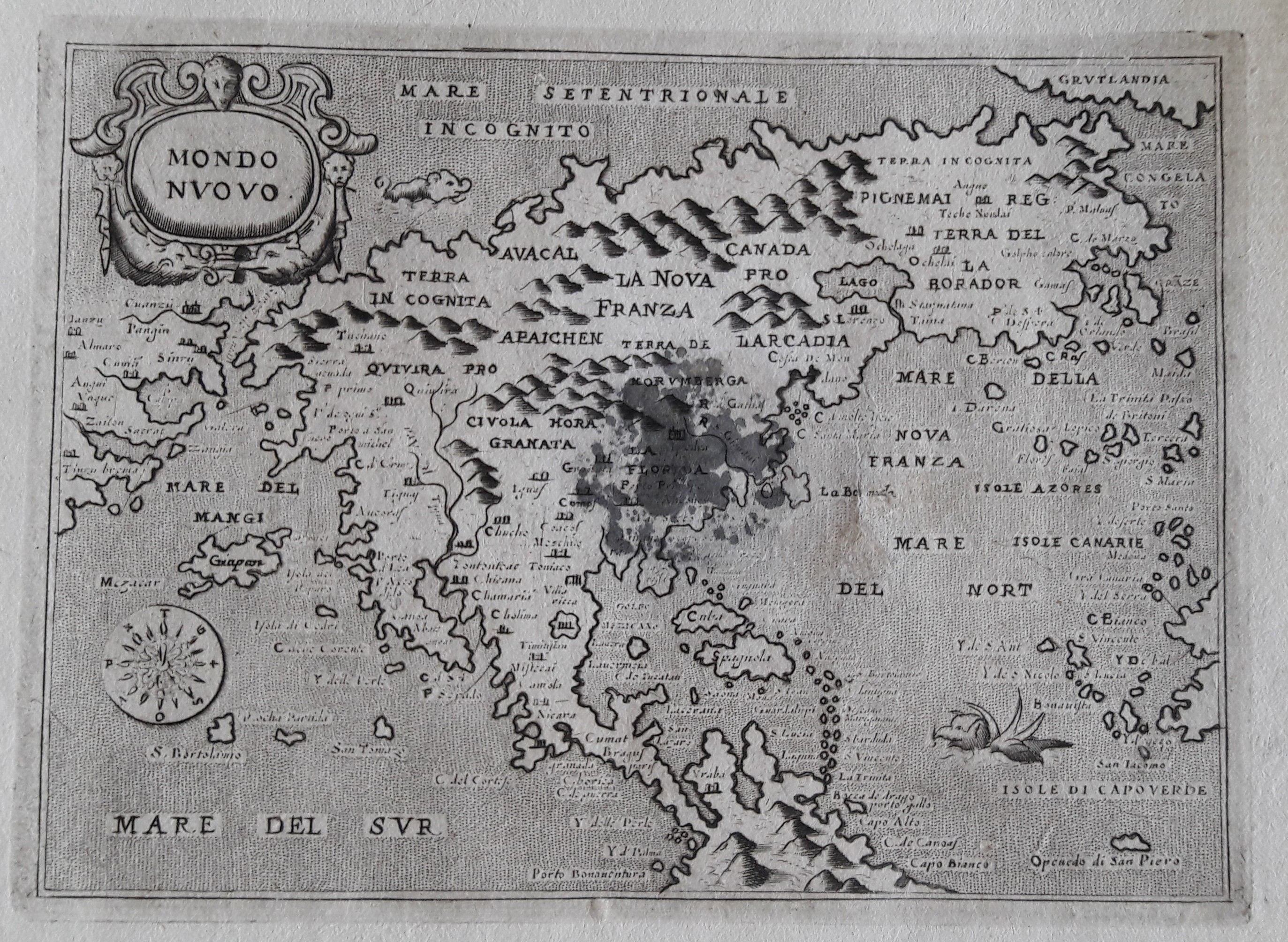
Mondo nuovo
Author
Porcacchi
Location shown in map
North America
Edition date
1686
Edition place
Venice
Editor
--
Atlas
L'Isole piu famose del mondo -- Pietr'Antonio Brigonci
Price
800 Euro
State
[mint/excellent/very good/good/fair/MEDIOCRE/poor]
Color
Black/white
Verso
Blank
Size
Plate: cm (14 x 11.4) inches (5.51 x 4.49) Paper: cm (17.8 x 16.5) inches (7.01 x 6.5)
Technique
Copper engraving
Note
Late edition for this beautiful map
Reference
--
Wiki
Here for more info
In stock
Available
Info
info@thetreasuremaps.com
Code
#0055
×
![Mondo nuovo by Porcacchi, North America, 1686]()
Map title
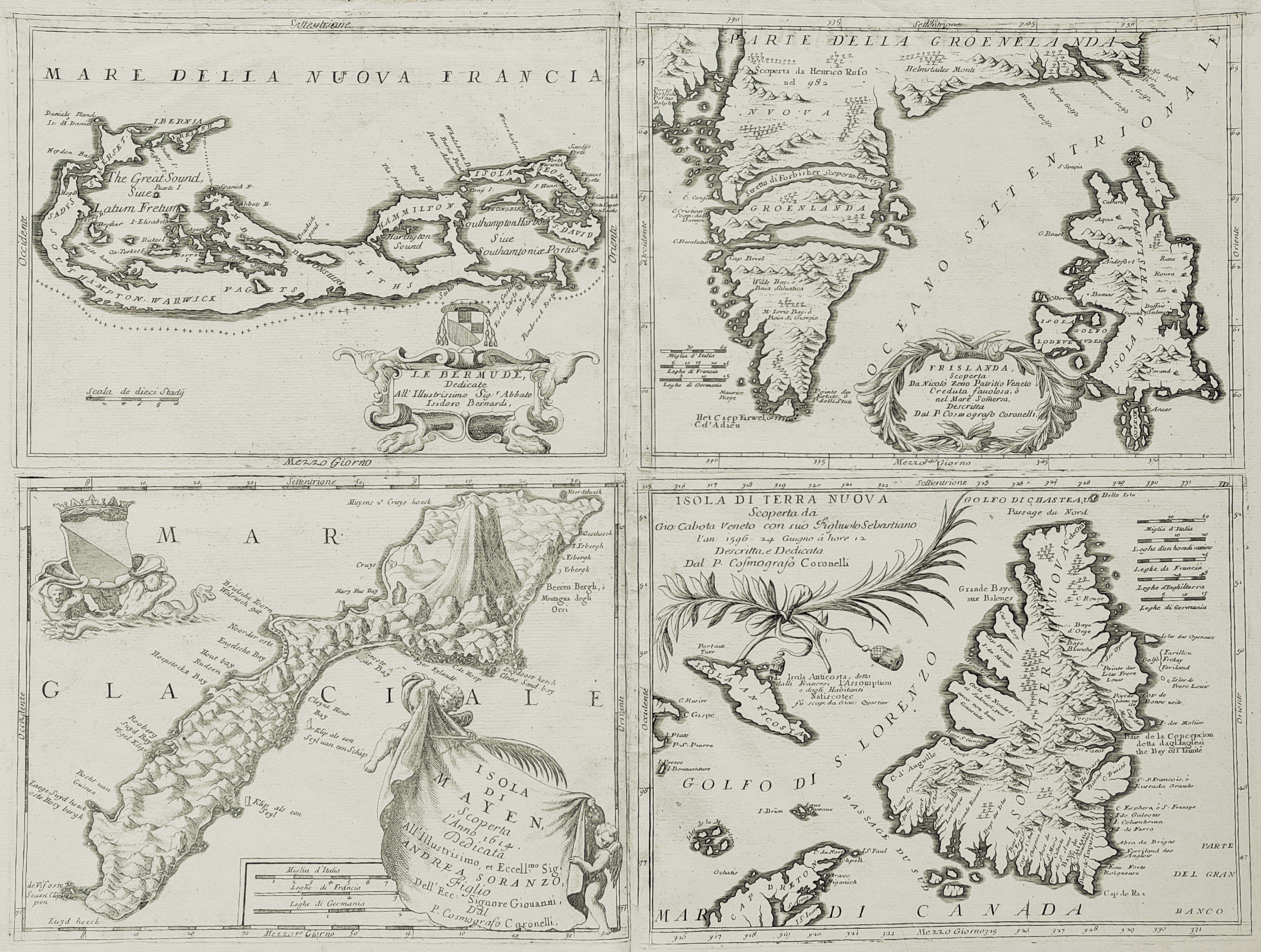
Islands
Author
Coronelli
Location shown in map
Bermuda, Iceland, Newfounland, Mayen
Edition date
Circa 1692
Edition place
Venice
Editor
--
Atlas
Atlante veneto
Price
1600 Euro
State
[mint/excellent/VERY GOOD/good/fair/mediocre/poor] Upper margin damaged
Color
Black/white
Verso
Blank
Size
Plate: cm (61 x 45.7) inches (24.02 x 17.99) Paper: cm (68.6 x 48.3) inches (27.01 x 19.02)
Technique
Copper engraving
Note
4 maps
Reference
--
Wiki
Here for more info
In stock
Available
Info
info@thetreasuremaps.com
Code
#0056
×
![Islands by Coronelli, Bermuda, Iceland, Newfounland, Mayen, Circa 1692]()
Map title
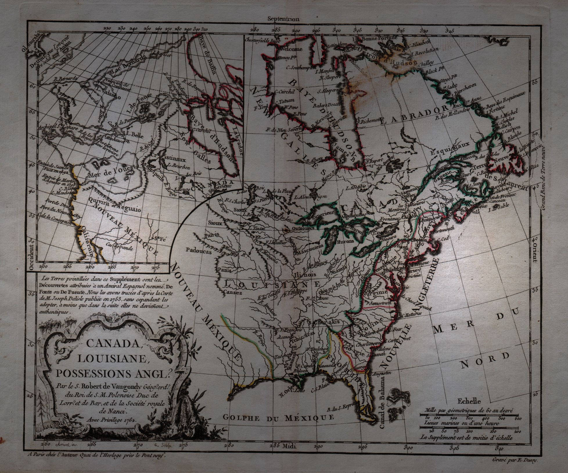
Canada, Louisiane, Possessions Anglais
Author
Robert de Vaugondy
Location shown in map
North America
Edition date
1762
Edition place
Paris
Editor
--
Atlas
Atlas Protatif
Price
300 Euro
State
[mint/EXCELLENT/very good/good/fair/mediocre/poor]
Color
Black/white
Verso
Blank
Size
Plate: cm (29.2 x 24.1) inches (11.5 x 9.49) Paper: cm (40.6 x 26.7) inches (15.98 x 10.51)
Technique
Copper engraving
Note
First state of this interesting map of the colonial possessions of England, France and Spain in North America. A large inset map covers the west coast and is most notable for its depiction of two remarkable cartographic misconceptions; a huge Mer de l' Ouest or Sea of the West and a Northwest Passage through a system of rivers and lakes connecting Hudson Bay with the Pacific based on the fictitious discoveries of Admiral de Font.
Reference
--
Wiki
Here for more info
In stock
Available
Info
info@thetreasuremaps.com
Code
#0058
×
![Canada, Louisiane, Possessions Anglais by Robert de Vaugondy, North America, 1762]()
Map title
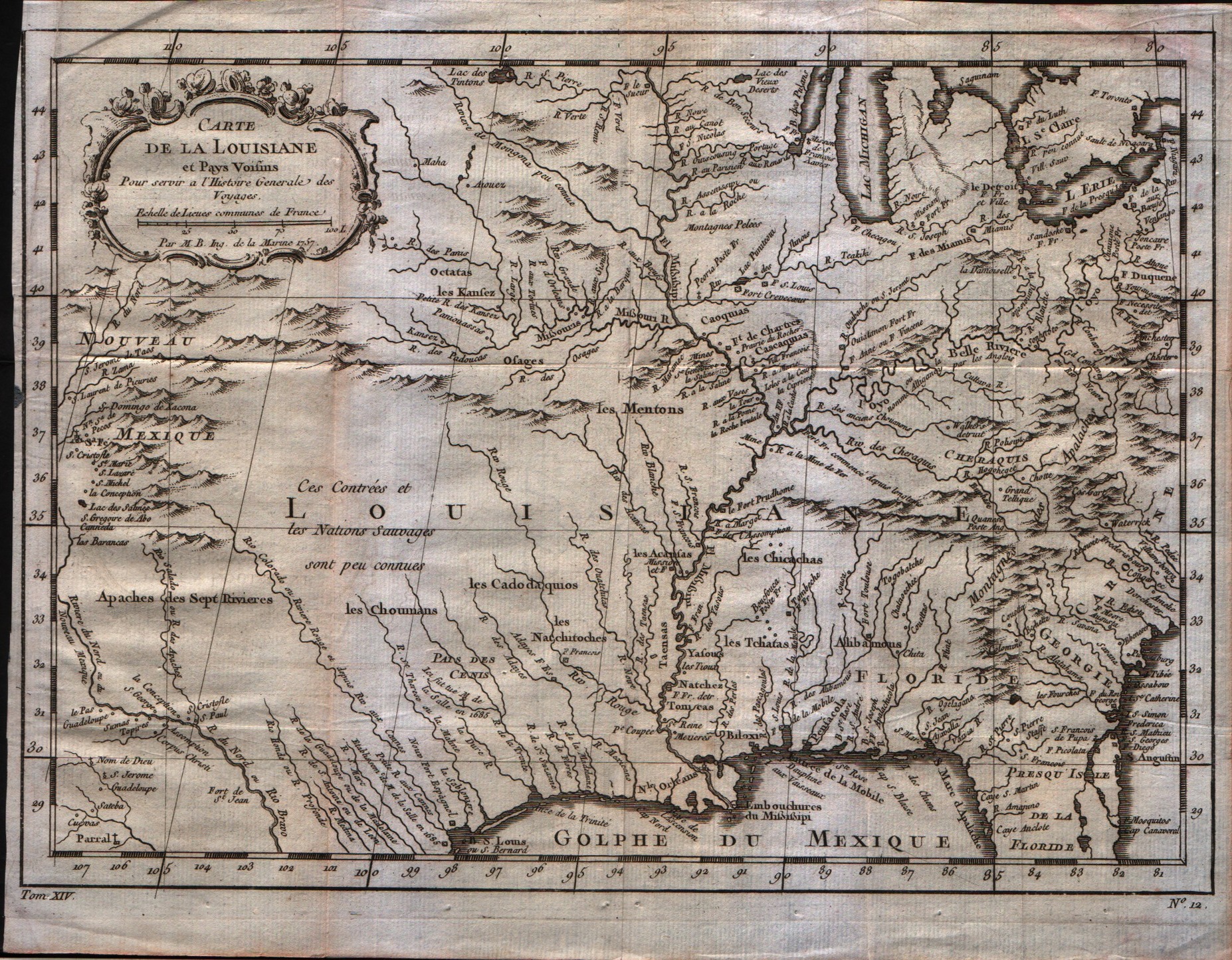
Carte de la Louisiane
Author
Bellin
Location shown in map
Louisiane
Edition date
1757
Edition place
Paris
Editor
--
Atlas
Historie General des Voyages -- Prevost
Price
350 Euro
State
[mint/excellent/VERY GOOD/good/fair/mediocre/poor]
Color
Black/white
Verso
Blank
Size
Plate: cm (30.5 x 21.6) inches (12.01 x 8.5) Paper: cm (30.5 x 24.1) inches (12.01 x 9.49)
Technique
Copper engraving
Note
Bellin notes all major river systems, especially the Mississippi system upon which their claims rested, and many of the French forts, including Detroit, Fort Duquesne (Pittsburgh), Fort de la Presque Isle (Erie), Sandoske, and Fort Checagou.
Reference
--
Wiki
Here for more info
In stock
Available
Info
info@thetreasuremaps.com
Code
#0059
×
![Carte de la Louisiane by Bellin, Louisiane, 1757]()
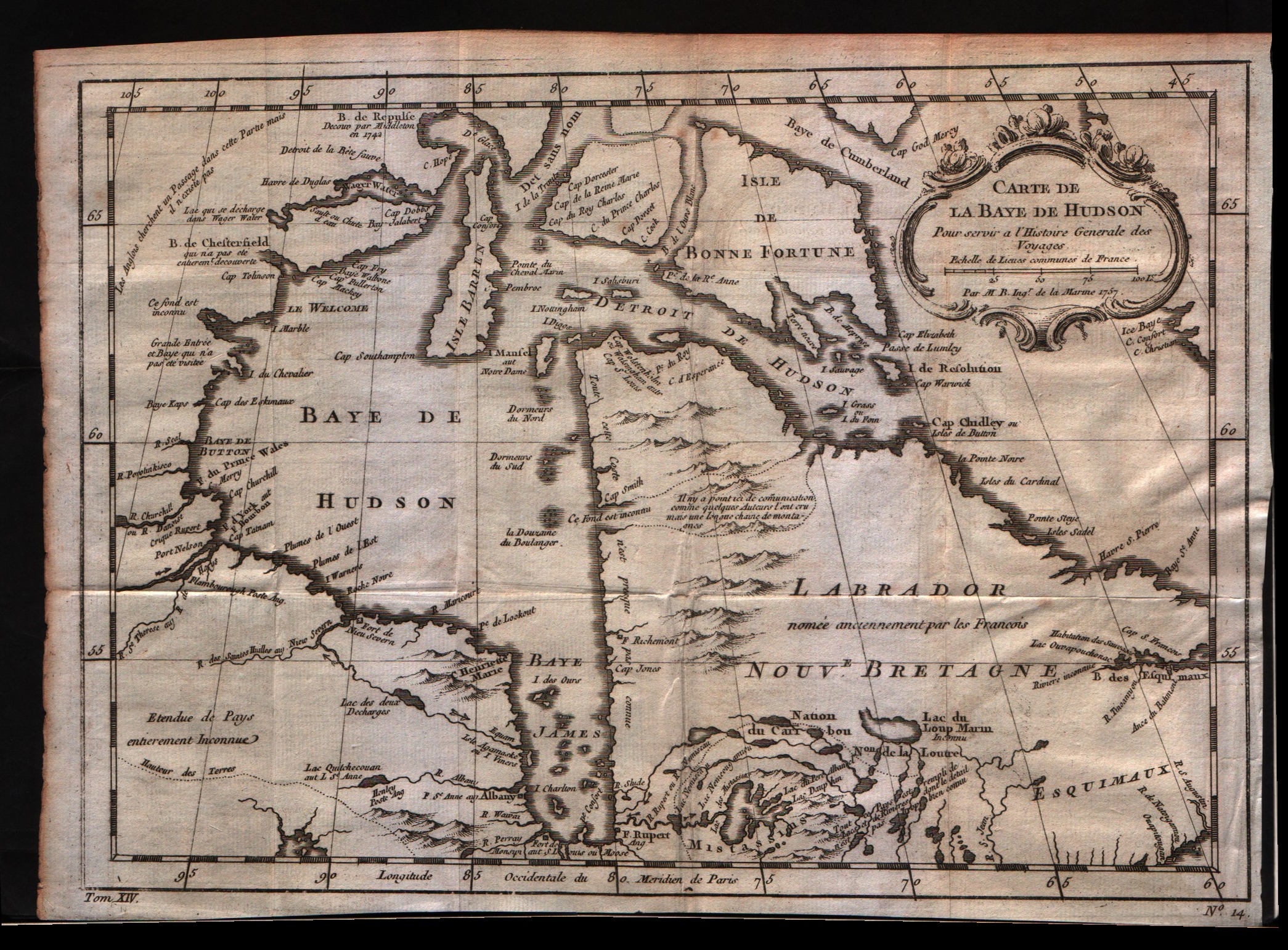
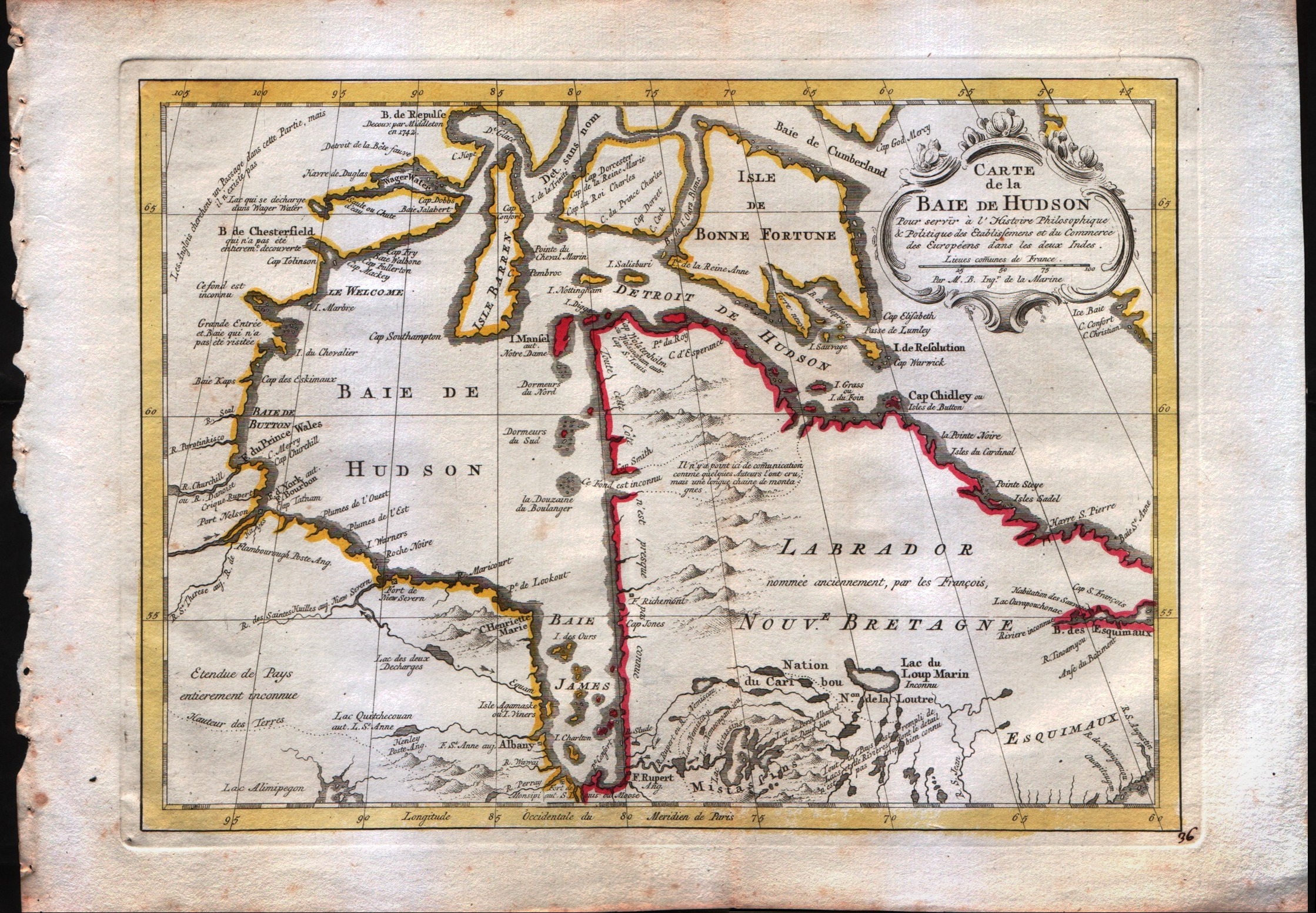
Map title
Carte de la baie de Hudson
Author
Bellin
Location shown in map
Hudson bay
Edition date
1757
Edition place
Paris
Editor
--
Atlas
Historie General des Voyages -- Prevost
Price
175 Euro
State
[mint/excellent/VERY GOOD/good/fair/mediocre/poor]
Color
Black/white
Verso
Blank
Size
Plate: cm (29.2 x 21.6) inches (11.5 x 8.5) Paper: cm (30.5 x 24.1) inches (12.01 x 9.49)
Technique
Copper engraving
Note
No particular notes for this maps
Reference
--
Wiki
Here for more info
In stock
Available
Info
info@thetreasuremaps.com
Code
#0061
×
![Carte de la baie de Hudson by Bellin, Hudson bay, 1757]()
Map title
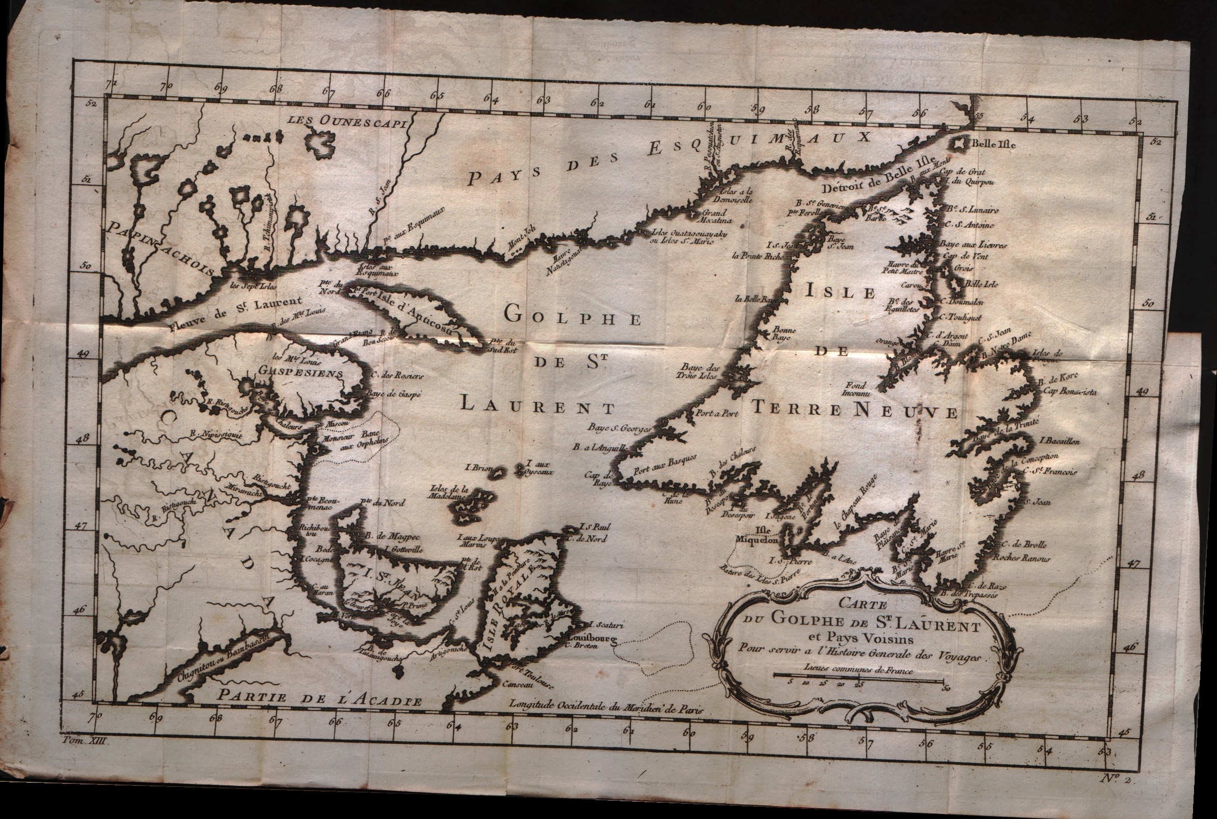
Carte du golphe de S.Laurent et pays voisins
Author
Bellin
Location shown in map
--
Edition date
1757
Edition place
Paris
Editor
--
Atlas
Historie General des Voyages -- Prevost
Price
150 Euro
State
[mint/excellent/VERY GOOD/good/fair/mediocre/poor]
Color
Black/white
Verso
Blank
Size
Plate: cm (34.3 x 21.6) inches (13.5 x 8.5) Paper: cm (38.1 x 25.4) inches (15 x 10)
Technique
Copper engraving
Note
No particular notes for this maps
Reference
--
Wiki
Here for more info
In stock
Available
Info
info@thetreasuremaps.com
Code
#0062
×
![Carte du golphe de S.Laurent et pays voisins by Bellin, --, 1757]()
Map title
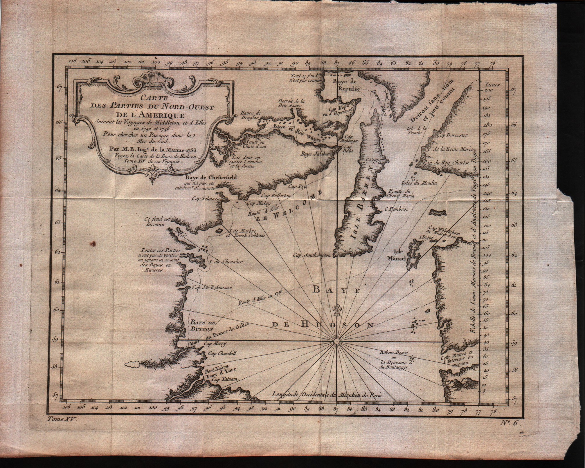
Carte des parties du Nord-Ouest de l'Amerique
Author
Bellin
Location shown in map
North-west of America
Edition date
1757
Edition place
Paris
Editor
--
Atlas
Historie General des Voyages -- Prevost
Price
125 Euro
State
[mint/excellent/VERY GOOD/good/fair/mediocre/poor]
Color
Black/white
Verso
Blank
Size
Plate: cm (27.3 x 22.2) inches (10.75 x 8.74) Paper: cm (31.8 x 26.7) inches (12.52 x 10.51)
Technique
Copper engraving
Note
No particular notes for this maps
Reference
--
Wiki
Here for more info
In stock
Available
Info
info@thetreasuremaps.com
Code
#0063
×
![Carte des parties du Nord-Ouest de l'Amerique by Bellin, North-west of America, 1757]()
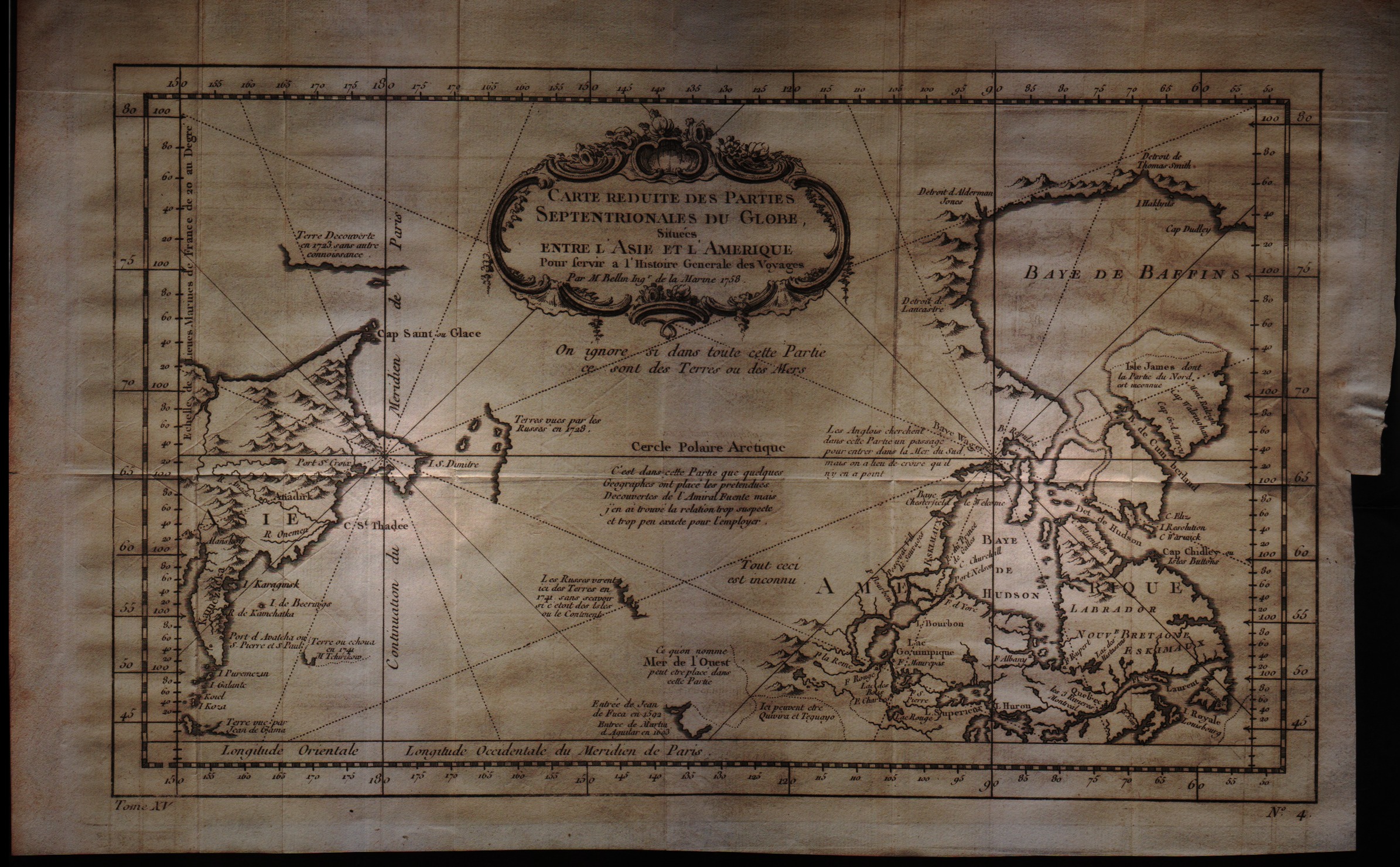
Map title
Carte reduite des parties Septentrionales du Globe situees entre l'Asie et l'Amerique
Author
Bellin
Location shown in map
--
Edition date
1757
Edition place
Paris
Editor
--
Atlas
Historie General des Voyages -- Prevost
Price
200 Euro
State
[mint/excellent/VERY GOOD/good/fair/mediocre/poor]
Color
Black/white
Verso
Blank
Size
Plate: cm (34.3 x 21.6) inches (13.5 x 8.5) Paper: cm (38.1 x 25.4) inches (15 x 10)
Technique
Copper engraving
Note
No particular notes for this maps
Reference
--
Wiki
Here for more info
In stock
Available
Info
info@thetreasuremaps.com
Code
#0064
×
![Carte reduite des parties Septentrionales du Globe situees entre l'Asie et l'Amerique by Bellin, --, 1757]()
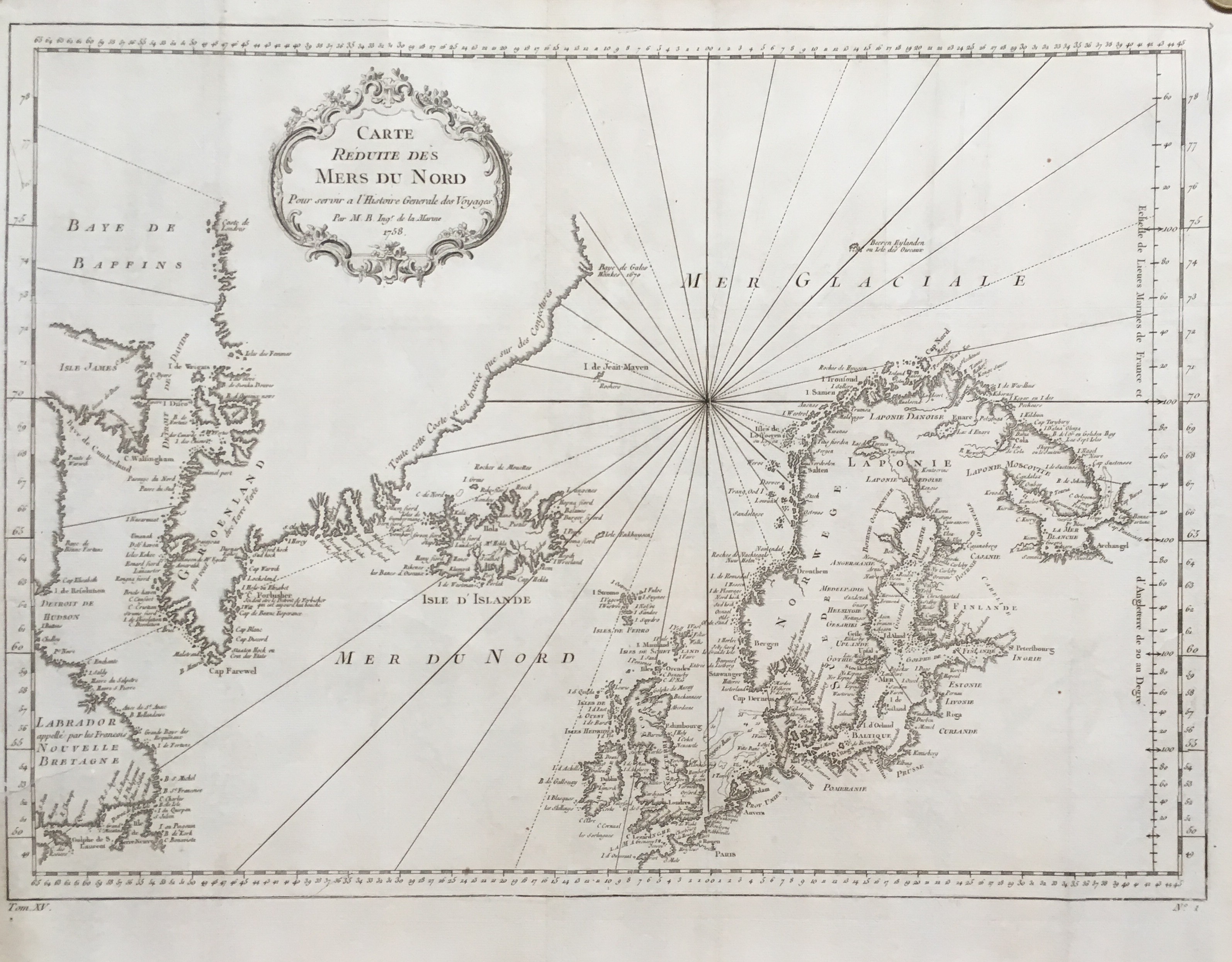
Map title
Carte reduite des mers du nord
Author
Bellin
Location shown in map
North Atlantic
Edition date
1757
Edition place
Paris
Editor
--
Atlas
Historie General des Voyages -- Prevost
Price
250 Euro
State
[mint/excellent/very good/good/fair/MEDIOCRE/poor], the map is damaged
Color
Black/white
Verso
Blank
Size
Plate: cm ( x ) inches (0 x 0) Paper: cm ( x ) inches (0 x 0)
Technique
Copper engraving
Note
No particular notes for this maps
Reference
--
Wiki
Here for more info
In stock
Available
Info
info@thetreasuremaps.com
Code
#0065
×
![Carte reduite des mers du nord by Bellin, North Atlantic, 1757]()
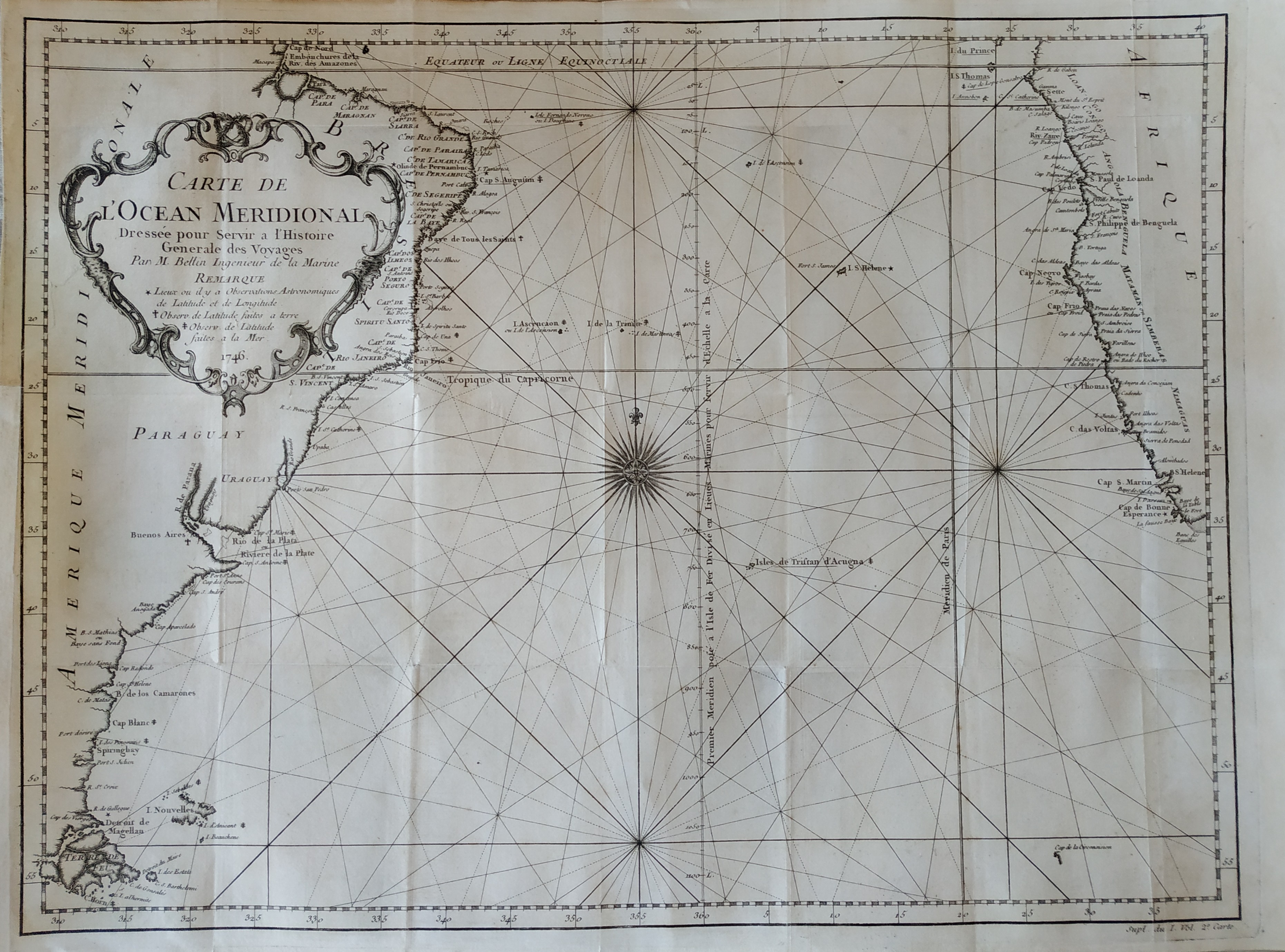
Map title
Carte de l'ocean Occidental
Author
Bellin
Location shown in map
Mid-Atlantic
Edition date
1757
Edition place
Paris
Editor
--
Atlas
Historie General des Voyages -- Prevost
Price
400 Euro
State
[mint/excellent/VERY GOOD/good/fair/mediocre/poor]
Color
Black/white
Verso
Blank
Size
Plate: cm (45.7 x 31.8) inches (17.99 x 12.52) Paper: cm (49.5 x 34.3) inches (19.49 x 13.5)
Technique
Copper engraving
Note
An attractive and desirable 18th-century nautical style map of the Atlantic Ocean, with parts of Western Africa, New England, Europe, and South America. The map boasts a highly decorative cartouche and beautiful compass rose. It is nicely engraved and names dozens of important cities and ports.
Reference
--
Wiki
Here for more info
In stock
Available
Info
info@thetreasuremaps.com
Code
#0066
×
![Carte de l'ocean Occidental by Bellin, Mid-Atlantic, 1757]()
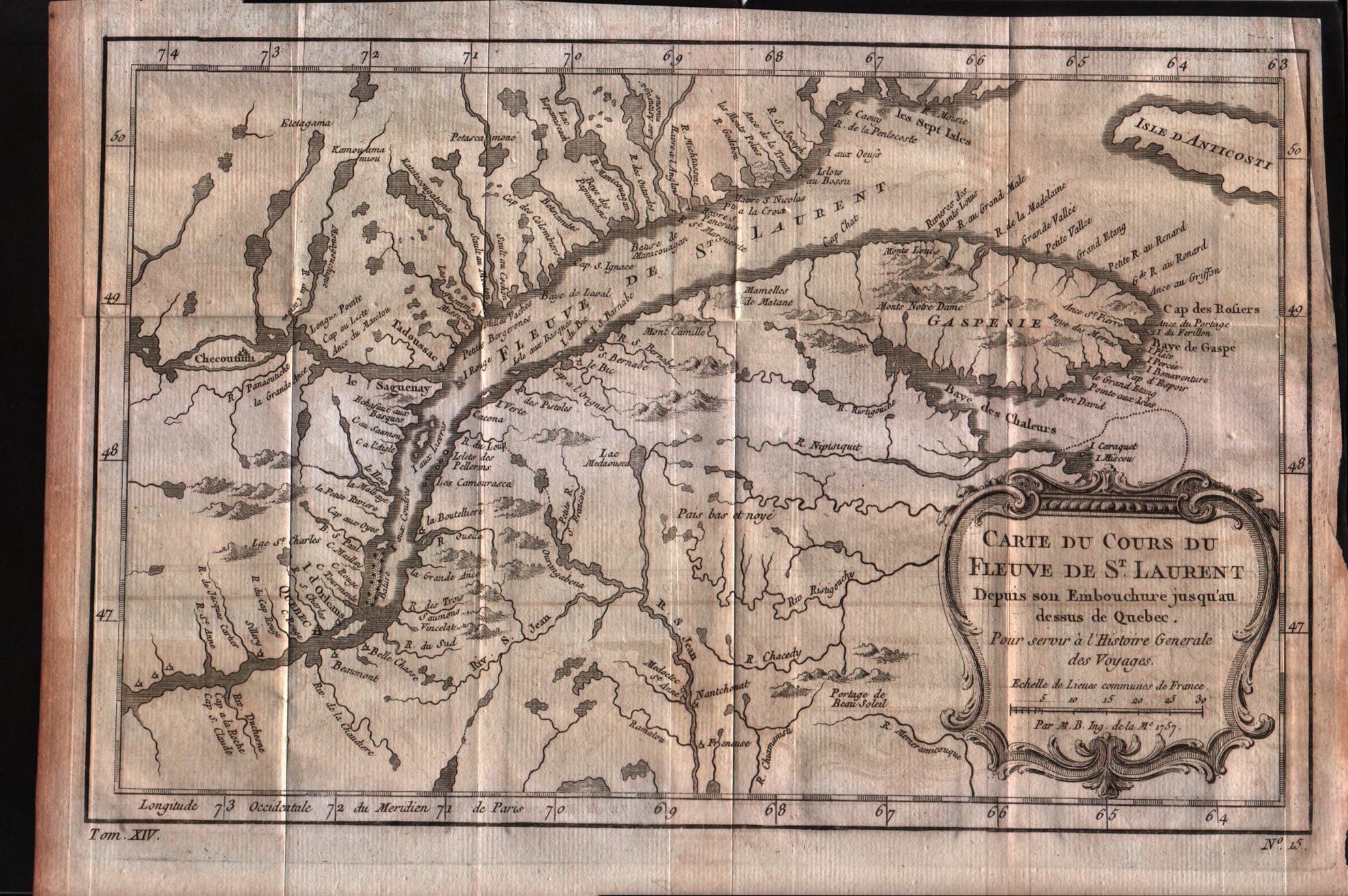
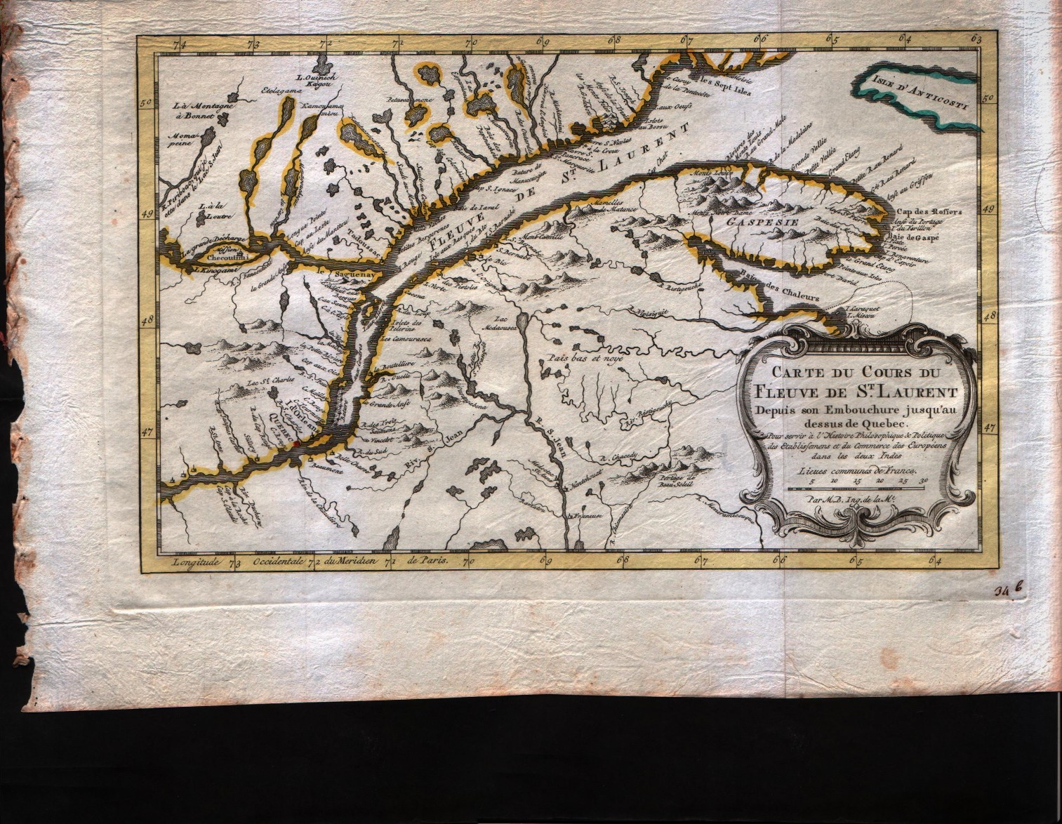
Map title
Carte du cours du Fleuve de S.Laurent depuis son embouchure jusqu'au dessus de Quebec
Author
Bellin
Location shown in map
--
Edition date
1757
Edition place
Paris
Editor
--
Atlas
Historie General des Voyages -- Prevost
Price
150 Euro
State
[mint/excellent/VERY GOOD/good/fair/mediocre/poor]
Color
Black/white
Verso
Blank
Size
Plate: cm (29.2 x 19) inches (11.5 x 7.48) Paper: cm (31.8 x 22.9) inches (12.52 x 9.02)
Technique
Copper engraving
Note
No particular notes for this maps
Reference
--
Wiki
Here for more info
In stock
Available
Info
info@thetreasuremaps.com
Code
#0068
×
![Carte du cours du Fleuve de S.Laurent depuis son embouchure jusqu'au dessus de Quebec by Bellin, --, 1757]()
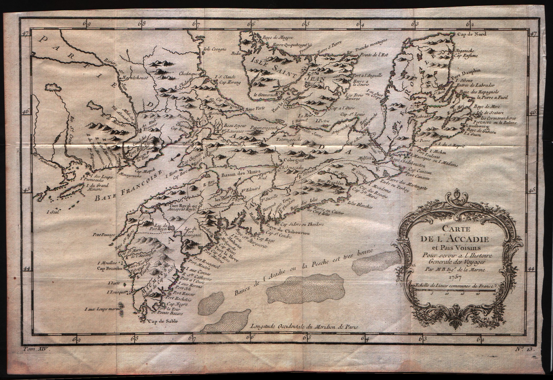
Map title
Carte de l'Acadie et pais voisins
Author
Bellin
Location shown in map
--
Edition date
1757
Edition place
Paris
Editor
--
Atlas
Historie General des Voyages -- Prevost
Price
200 Euro
State
[mint/excellent/VERY GOOD/good/fair/mediocre/poor]
Color
Black/white
Verso
Blank
Size
Plate: cm (31.8 x 20.3) inches (12.52 x 7.99) Paper: cm (34.3 x 24.1) inches (13.5 x 9.49)
Technique
Copper engraving
Note
No particular notes for this maps
Reference
--
Wiki
Here for more info
In stock
Available
Info
info@thetreasuremaps.com
Code
#0069
×
![Carte de l'Acadie et pais voisins by Bellin, --, 1757]()
Map title
Carte du cours du Fleuve de S.Laurent depuis son embouchure jusqu'au dessus de Quebec
Author
Bellin
Location shown in map
--
Edition date
1773
Edition place
Amsterdam
Editor
--
Atlas
Atlas Portatif -- E. van Harrevelt
Price
150 Euro
State
[mint/EXCELLENT/very good/good/fair/mediocre/poor]
Color
Old colors
Verso
Blank
Size
Plate: cm (29.2 x 19) inches (11.5 x 7.48) Paper: cm (39.4 x 26.7) inches (15.51 x 10.51)
Technique
Copper engraving
Note
No particular notes for this maps
Reference
--
Wiki
Here for more info
In stock
Available
Info
info@thetreasuremaps.com
Code
#0070
×
![Carte du cours du Fleuve de S.Laurent depuis son embouchure jusqu'au dessus de Quebec by Bellin, --, 1773]()
Map title
Carte du Golphe du Mexique et des Isles de l'Amerique
Author
Bellin
Location shown in map
--
Edition date
1773
Edition place
Amsterdam
Editor
--
Atlas
Atlas Portatif -- E. van Harrevelt
Price
275 Euro
State
[mint/EXCELLENT/very good/good/fair/mediocre/poor]
Color
Old colors
Verso
Blank
Size
Plate: cm (36.8 x 26.7) inches (14.49 x 10.51) Paper: cm (39.4 x 31.8) inches (15.51 x 12.52)
Technique
Copper engraving
Note
No particular notes for this maps
Reference
--
Wiki
Here for more info
In stock
Available
Info
info@thetreasuremaps.com
Code
#0071
×
![Carte du Golphe du Mexique et des Isles de l'Amerique by Bellin, --, 1773]()
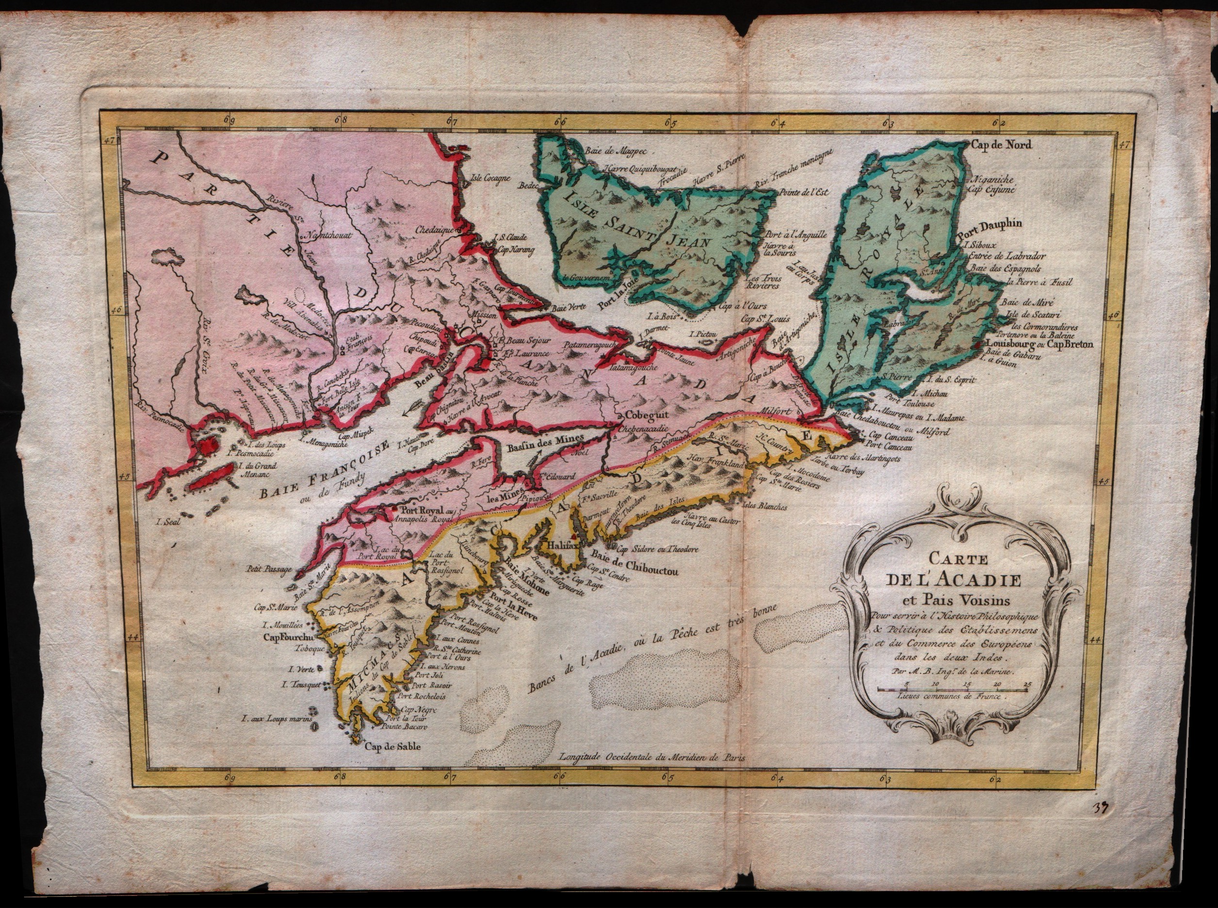
Map title
Carte de l'Acadie et pais voisins
Author
Bellin
Location shown in map
--
Edition date
1773
Edition place
Amsterdam
Editor
--
Atlas
Atlas Portatif -- E. van Harrevelt
Price
200 Euro
State
[mint/excellent/VERY GOOD/good/fair/mediocre/poor]
Color
Old colors
Verso
Blank
Size
Plate: cm (31.8 x 20.3) inches (12.52 x 7.99) Paper: cm (38.1 x 26.7) inches (15 x 10.51)
Technique
Copper engraving
Note
No particular notes for this maps
Reference
--
Wiki
Here for more info
In stock
Available
Info
info@thetreasuremaps.com
Code
#0072
×
![Carte de l'Acadie et pais voisins by Bellin, --, 1773]()
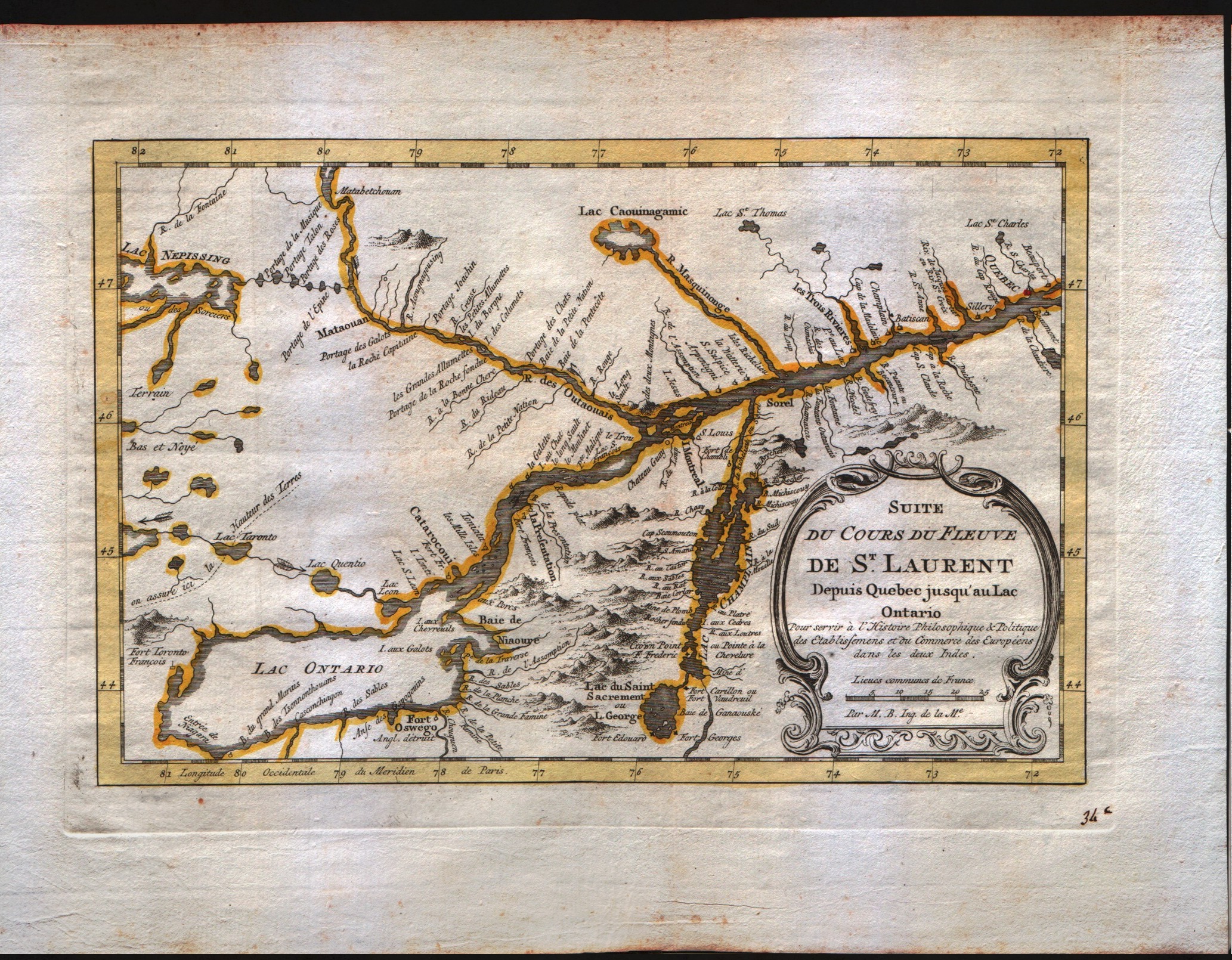
Map title
Suite du cours du Fleuve de S.Laurent depuis Quebec jusqu'au Lac Ontario
Author
Bellin
Location shown in map
--
Edition date
1773
Edition place
Amsterdam
Editor
--
Atlas
Atlas Portatif -- E. van Harrevelt
Price
200 Euro
State
[mint/EXCELLENT/very good/good/fair/mediocre/poor]
Color
Old colors
Verso
Blank
Size
Plate: cm (27.9 x 17.8) inches (10.98 x 7.01) Paper: cm (35.6 x 26.7) inches (14.02 x 10.51)
Technique
Copper engraving
Note
No particular notes for this maps
Reference
--
Wiki
Here for more info
In stock
Available
Info
info@thetreasuremaps.com
Code
#0073
×
![Suite du cours du Fleuve de S.Laurent depuis Quebec jusqu'au Lac Ontario by Bellin, --, 1773]()
Map title
Carte de la baie de Hudson
Author
Bellin
Location shown in map
--
Edition date
1773
Edition place
Amsterdam
Editor
--
Atlas
Atlas Portatif -- E. van Harrevelt
Price
175 Euro
State
[mint/EXCELLENT/very good/good/fair/mediocre/poor]
Color
Old colors
Verso
Blank
Size
Plate: cm (29.2 x 21.6) inches (11.5 x 8.5) Paper: cm (36.8 x 26.7) inches (14.49 x 10.51)
Technique
Copper engraving
Note
No particular notes for this maps
Reference
--
Wiki
Here for more info
In stock
Available
Info
info@thetreasuremaps.com
Code
#0074
×
![Carte de la baie de Hudson by Bellin, --, 1773]()
Map title
Carte du golphe de S.Laurent et pays voisins
Author
Bellin
Location shown in map
--
Edition date
1773
Edition place
Amsterdam
Editor
--
Atlas
Atlas Portatif -- E. van Harrevelt
Price
150 Euro
State
[mint/EXCELLENT/very good/good/fair/mediocre/poor]
Color
Old colors
Verso
Blank
Size
Plate: cm (34.3 x 21.6) inches (13.5 x 8.5) Paper: cm (41.9 x 26.7) inches (16.5 x 10.51)
Technique
Copper engraving
Note
No particular notes for this maps
Reference
--
Wiki
Here for more info
In stock
Available
Info
info@thetreasuremaps.com
Code
#0080
×
![Carte du golphe de S.Laurent et pays voisins by Bellin, --, 1773]()
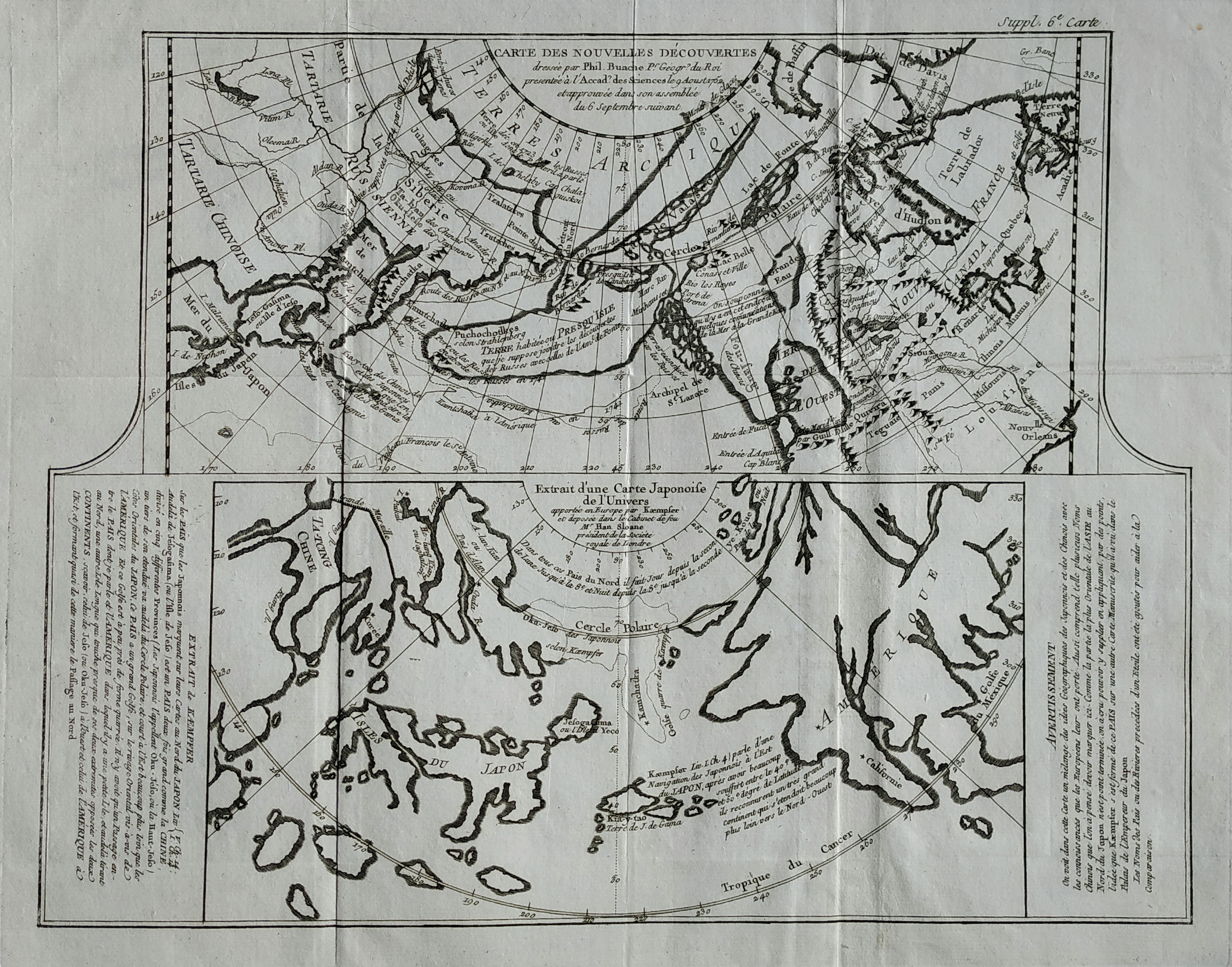
Map title
Carte des nouvelles decouvertes
Author
Diderot
Location shown in map
North America
Edition date
1772
Edition place
Paris
Editor
--
Atlas
Encyclopedie -- De Vaugondy
Price
125 Euro
State
[mint/EXCELLENT/very good/good/fair/mediocre/poor]
Color
Black/white
Verso
Blank
Size
Plate: cm (40.6 x 31.8) inches (15.98 x 12.52) Paper: cm (50.8 x 40.6) inches (20 x 15.98)
Technique
Copper engraving
Note
No particular notes for this maps
Reference
--
Wiki
Here for more info
In stock
Available
Info
info@thetreasuremaps.com
Code
#0081
×
![Carte des nouvelles decouvertes by Diderot, North America, 1772]()