News
Map title
Descriptio insulae Gothlandiae
Author
Bertius
Location shown in map
Sweden
Edition date
1600
Edition place
Amsterdam
Editor
--
Atlas
Tabularum geographicarum contractarum
Price
200 Euro
State
[mint/EXCELLENT/very good/good/fair/mediocre/poor]
Color
Black/white
Verso
Latin text
Size
Plate: cm (12 x 9) inches (4.72 x 3.54) Paper: cm (18 x 12) inches (7.09 x 4.72)
Technique
Copper engraving
Note
Reference
Wiki
Here for more info
In stock
Available
Info
info@thetreasuremaps.com
Code
#1325
×
![Descriptio insulae Gothlandiae by Bertius, Sweden, 1600]()
Map title
Histriae tabula a Pietro Coppo
Author
Ortelius
Location shown in map
Istria
Edition date
Circa 1575
Edition place
Antwerp
Editor
--
Atlas
Theatrum Orbis Terrarum
Price
150 Euro
State
[mint/excellent/very good/GOOD/fair/mediocre/poor]
Color
Old colors
Verso
Blank
Size
Plate: cm (24 x 33) inches (9.45 x 12.99) Paper: cm (27 x 41) inches (10.63 x 16.14)
Technique
Copper engraving
Note
Reference
Van Den Broecke 192
Wiki
Here for more info
In stock
Available
Info
info@thetreasuremaps.com
Code
#1326
×
![Histriae tabula a Pietro Coppo by Ortelius, Istria, Circa 1575]()
Map title
Carte de la Coree et du Japon
Author
Brion de la Tour
Location shown in map
Japan
Edition date
Circa 1780
Edition place
Paris
Editor
Atlas
Price
200 Euro
State
[mint/EXCELLENT/very good/good/fair/mediocre/poor]
Color
Black/white
Verso
Blank
Size
Plate: cm (35 x 24) inches (13.78 x 9.45) Paper: cm (38 x 27) inches (14.96 x 10.63)
Technique
Copper engraving
Note
Reference
Wiki
Here for more info
In stock
Available
Info
info@thetreasuremaps.com
Code
#1322
×
![Carte de la Coree et du Japon by Brion de la Tour, Japan, Circa 1780]()
Map title
Stato della Chiesa
Author
Magini
Location shown in map
Lazio
Edition date
1620
Edition place
Bologna
Editor
F. Magini
Atlas
L'Italia
Price
350 Euro
State
[mint/excellent/very good/GOOD/fair/mediocre/poor]
Color
Black/white
Verso
Blank
Size
Plate: cm (43 x 36) inches (16.93 x 14.17) Paper: cm (50 x 40) inches (19.69 x 15.75)
Technique
Copper engraving
Note
Reference
--
Wiki
Here for more info
In stock
Available
Info
info@thetreasuremaps.com
Code
#1309
×
![Stato della Chiesa by Magini, Lazio, 1620]()
Map title
Mappamondo o sia descrizione generale del globo terrestre ed acquatico
Author
Albrizzi
Location shown in map
World
Edition date
Circa 1740
Edition place
Venice
Editor
Atlas
Price
600 Euro
State
[mint/EXCELLENT/very good/good/fair/mediocre/poor]
Color
Black/white
Verso
Blank
Size
Plate: cm (36 x 30) inches (14.17 x 11.81) Paper: cm (47 x 37) inches (18.5 x 14.57)
Technique
Copper engraving
Note
Reference
Wiki
Here for more info
In stock
Available
Info
info@thetreasuremaps.com
Code
#1359
×
![Mappamondo o sia descrizione generale del globo terrestre ed acquatico by Albrizzi, World, Circa 1740]()
Map title
Italia
Author
Corbetta
Location shown in map
Italy
Edition date
1853
Edition place
Milano
Editor
Atlas
La Geografia a Colpo d'Occhio
Price
800 Euro
State
[mint/EXCELLENT/very good/good/fair/mediocre/poor]
Color
Old colors
Verso
Blank
Size
Plate: cm (63 x 43) inches (24.8 x 16.93) Paper: cm (72 x 50) inches (28.35 x 19.69)
Technique
Copper engraving
Note
Reference
Wiki
Here for more info
In stock
Available
Info
info@thetreasuremaps.com
Code
#1358
×
![Italia by Corbetta, Italy, 1853]()
Map title
Status Ecclesiastici nec non Magni Ducatus Toscanae Nova Tabula Geographica
Author
Homann
Location shown in map
Lazio
Edition date
1748
Edition place
Amsterdam
Editor
Atlas
L'Italia
Price
250 Euro
State
[mint/EXCELLENT/very good/good/fair/mediocre/poor]
Color
Old colors
Verso
Blank
Size
Plate: cm (53 x 48) inches (20.87 x 18.9) Paper: cm (59 x 50) inches (23.23 x 19.69)
Technique
Copper engraving
Note
Reference
--
Wiki
Here for more info
In stock
Available
Info
info@thetreasuremaps.com
Code
#1324
×
![Status Ecclesiastici nec non Magni Ducatus Toscanae Nova Tabula Geographica by Homann, Lazio, 1748]()
Map title
A view of Messina
Author
Mazell
Location shown in map
Messina
Edition date
1783
Edition place
London
Editor
Atlas
Travels in the two Sicilies
Price
450 Euro
State
[mint/EXCELLENT/very good/good/fair/mediocre/poor]
Color
Black/white
Verso
Blank
Size
Plate: cm (53 x 26) inches (20.87 x 10.24) Paper: cm (58 x 34) inches (22.83 x 13.39)
Technique
Copper engraving
Note
Reference
Wiki
Here for more info
In stock
Available
Info
info@thetreasuremaps.com
Code
#1314
×
![A view of Messina by Mazell, Messina, 1783]()
Map title
Vera lombardia come fu terminata da Carlo Magno
Author
Berey
Location shown in map
North Italy
Edition date
1664
Edition place
Turin
Editor
Zavatta
Atlas
Del regno d'Italia sotto i barbari epitome
Price
700 Euro
State
[mint/EXCELLENT/very good/good/fair/mediocre/poor]
Color
Old colors
Verso
Blank
Size
Plate: cm (36 x 28) inches (14.17 x 11.02) Paper: cm (40 x 32) inches (15.75 x 12.6)
Technique
Copper engraving
Note
Reference
Wiki
Here for more info
In stock
Available
Info
info@thetreasuremaps.com
Code
#1308
×
![Vera lombardia come fu terminata da Carlo Magno by Berey, North Italy, 1664]()
Map title
Regni Daniae
Author
Jansson
Location shown in map
Denmark
Edition date
Circa 1647
Edition place
Amsterdam
Editor
Atlas
Price
400 Euro
State
[mint/EXCELLENT/very good/good/fair/mediocre/poor]
Color
Old colors
Verso
Latin text
Size
Plate: cm (56 x 45) inches (22.05 x 17.72) Paper: cm (58 x 49) inches (22.83 x 19.29)
Technique
Copper engraving
Note
Reference
Wiki
Here for more info
In stock
Available
Info
info@thetreasuremaps.com
Code
#1311
×
![Regni Daniae by Jansson, Denmark, Circa 1647]()
Map title
Italien
Author
Hengelhorn
Location shown in map
Italy
Edition date
1879
Edition place
Stutgard
Editor
Atlas
Price
200 Euro
State
[mint/EXCELLENT/very good/good/fair/mediocre/poor]
Color
Old colors
Verso
Blank
Size
Plate: cm (54 x 64) inches (21.26 x 25.2) Paper: cm (57 x 70) inches (22.44 x 27.56)
Technique
Steel engraving
Note
Reference
Wiki
Here for more info
In stock
Available
Info
info@thetreasuremaps.com
Code
#1313
×
![Italien by Hengelhorn, Italy, 1879]()
Map title
Carta della nuova Italia
Author
Location shown in map
Italy
Edition date
Circa 1910
Edition place
Firenze
Editor
Nerbini
Atlas
Price
50 Euro
State
[mint/excellent/very good/GOOD/fair/mediocre/poor]
Color
Old colors
Verso
Blank
Size
Plate: cm (50 x 32) inches (19.69 x 12.6) Paper: cm (57 x 40) inches (22.44 x 15.75)
Technique
Steel engraving
Note
Reference
Wiki
Here for more info
In stock
Available
Info
info@thetreasuremaps.com
Code
#1315
×
![Carta della nuova Italia by , Italy, Circa 1910]()
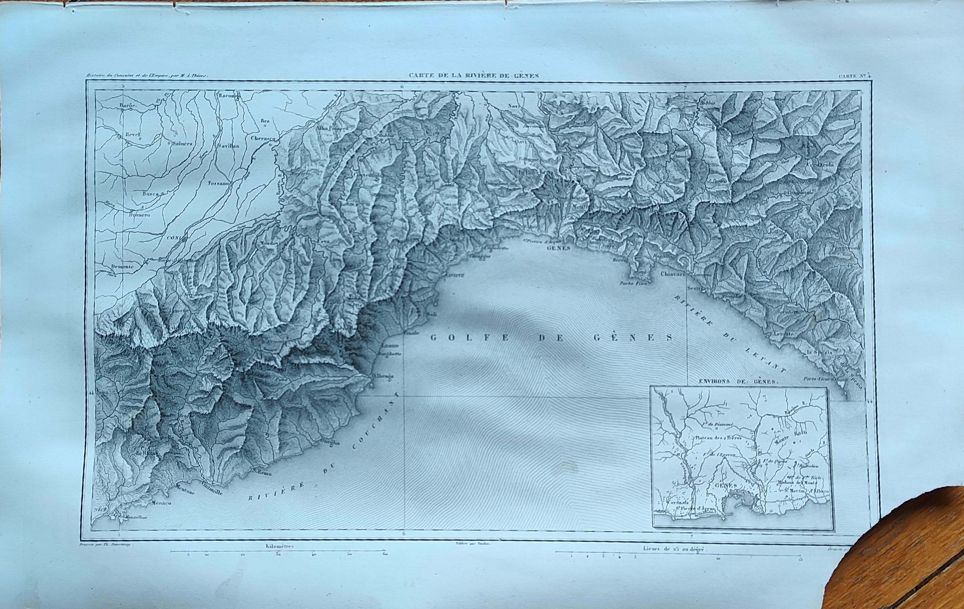
Map title
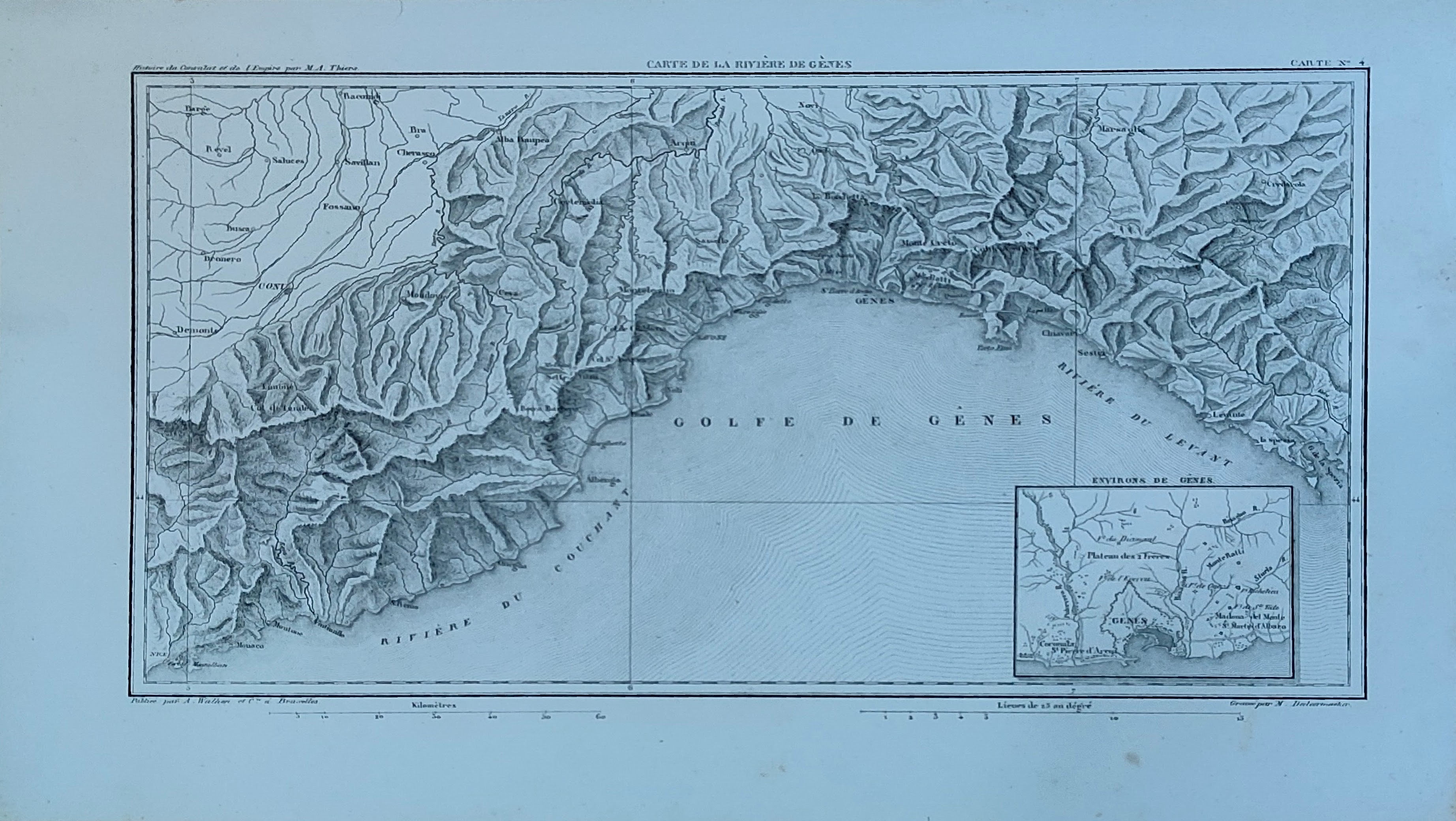
Carte de la riviere de Genes
Author
Dufour
Location shown in map
Liguria
Edition date
1859
Edition place
Paris
Editor
Atlas
Atlas de l'histoire du consulat et de L'Empire
Price
75 Euro
State
[mint/EXCELLENT/very good/good/fair/mediocre/poor]
Color
Old colors
Verso
Blank
Size
Plate: cm (35 x 20) inches (13.78 x 7.87) Paper: cm (41 x 27) inches (16.14 x 10.63)
Technique
Steel engraving
Note
Reference
Wiki
Here for more info
In stock
Available
Info
info@thetreasuremaps.com
Code
#1317
×
![Carte de la riviere de Genes by Dufour, Liguria, 1859]()
Map title
Italia nel 1945
Author
Location shown in map
Italy
Edition date
1951
Edition place
Torino
Editor
De Agostini
Atlas
Imago Italiae
Price
50 Euro
State
[mint/EXCELLENT/very good/good/fair/mediocre/poor]
Color
Old colors
Verso
Blank
Size
Plate: cm (20 x 25) inches (7.87 x 9.84) Paper: cm (24 x 34) inches (9.45 x 13.39)
Technique
Steel engraving
Note
Reference
Wiki
Here for more info
In stock
Available
Info
info@thetreasuremaps.com
Code
#1319
×
![Italia nel 1945 by , Italy, 1951]()
Map title
Carte du Piemont
Author
Dufour
Location shown in map
Liguria
Edition date
1859
Edition place
Paris
Editor
Atlas
Atlas de l'histoire du consulat et de L'Empire
Price
50 Euro
State
[mint/EXCELLENT/very good/good/fair/mediocre/poor]
Color
Old colors
Verso
Blank
Size
Plate: cm (20 x 20) inches (7.87 x 7.87) Paper: cm (41 x 27) inches (16.14 x 10.63)
Technique
Steel engraving
Note
Reference
Wiki
Here for more info
In stock
Available
Info
info@thetreasuremaps.com
Code
#1318
×
![Carte du Piemont by Dufour, Liguria, 1859]()
Map title
Italia
Author
Location shown in map
Italy
Edition date
1951
Edition place
Torino
Editor
De Agostini
Atlas
Imago Italiae
Price
50 Euro
State
[mint/EXCELLENT/very good/good/fair/mediocre/poor]
Color
Old colors
Verso
Blank
Size
Plate: cm (20 x 25) inches (7.87 x 9.84) Paper: cm (24 x 34) inches (9.45 x 13.39)
Technique
Steel engraving
Note
Reference
Wiki
Here for more info
In stock
Available
Info
info@thetreasuremaps.com
Code
#1321
×
![Italia by , Italy, 1951]()
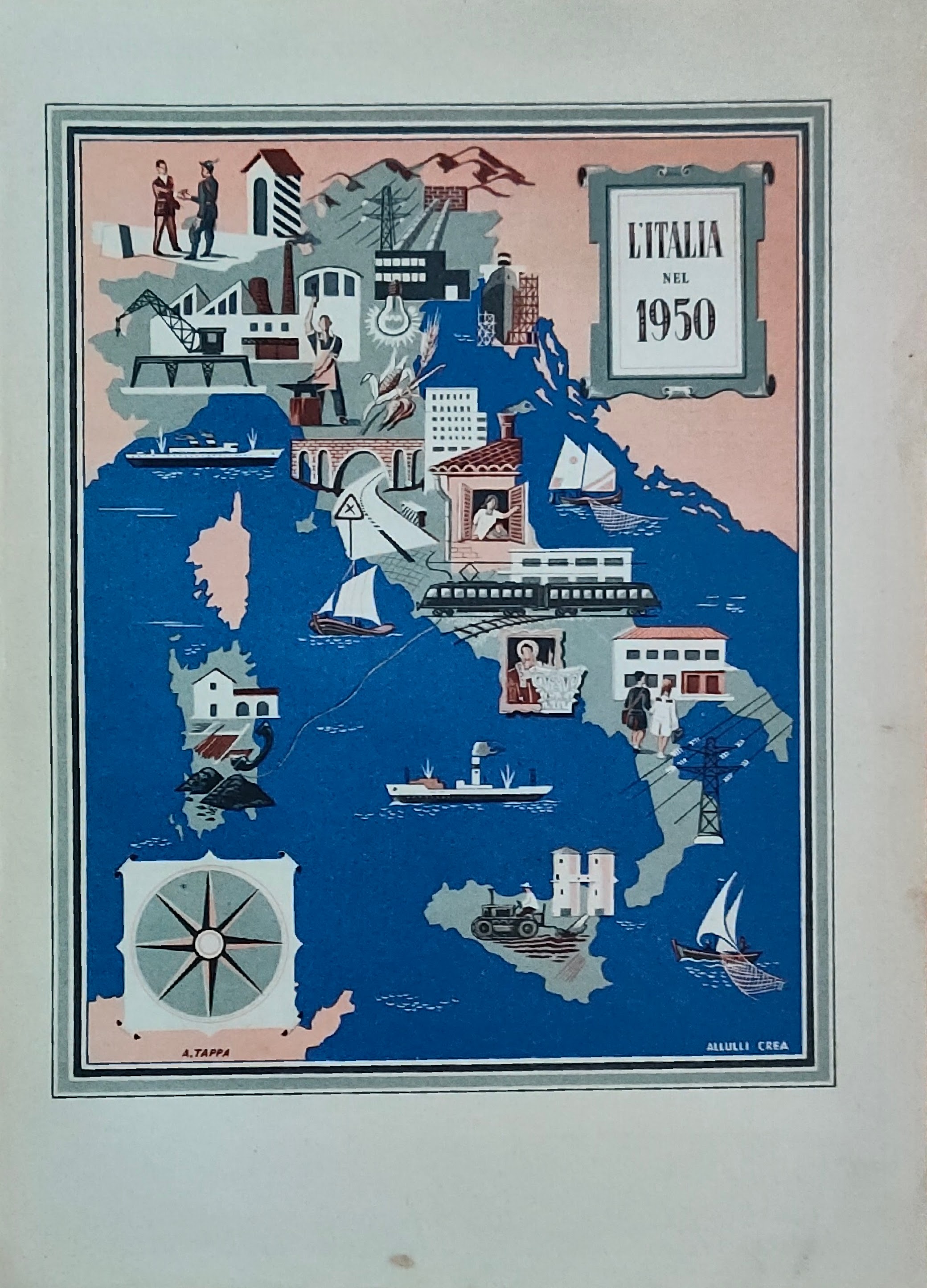
Map title
Italia nel 1950
Author
Location shown in map
Italy
Edition date
1951
Edition place
Torino
Editor
De Agostini
Atlas
Imago Italiae
Price
50 Euro
State
[mint/EXCELLENT/very good/good/fair/mediocre/poor]
Color
Old colors
Verso
Blank
Size
Plate: cm (20 x 25) inches (7.87 x 9.84) Paper: cm (24 x 34) inches (9.45 x 13.39)
Technique
Steel engraving
Note
Reference
Wiki
Here for more info
In stock
Available
Info
info@thetreasuremaps.com
Code
#1320
×
![Italia nel 1950 by , Italy, 1951]()
Map title
Liguria
Author
Duvotenay
Location shown in map
Liguria
Edition date
Circa 1840
Edition place
Paris
Editor
Atlas
Price
50 Euro
State
[mint/excellent/very good/good/FAIR/mediocre/poor]
Color
Black/white
Verso
Blank
Size
Plate: cm (36 x 21) inches (14.17 x 8.27) Paper: cm (43 x 28) inches (16.93 x 11.02)
Technique
Steel engraving
Note
Reference
Wiki
Here for more info
In stock
Available
Info
info@thetreasuremaps.com
Code
#1306
Liguria
Author
Duvotenay
Location shown in map
Liguria
Edition date
Circa 1840
Edition place
Paris
Editor
Atlas
Price
50 Euro
State
[mint/excellent/very good/good/FAIR/mediocre/poor]
Color
Black/white
Verso
Blank
Size
Plate: cm (36 x 21) inches (14.17 x 8.27) Paper: cm (43 x 28) inches (16.93 x 11.02)
Technique
Steel engraving
Note
Reference
Wiki
Here for more info
In stock
Available
Info
info@thetreasuremaps.com
Code
#1306
×
![Liguria by Duvotenay, Liguria, Circa 1840]()
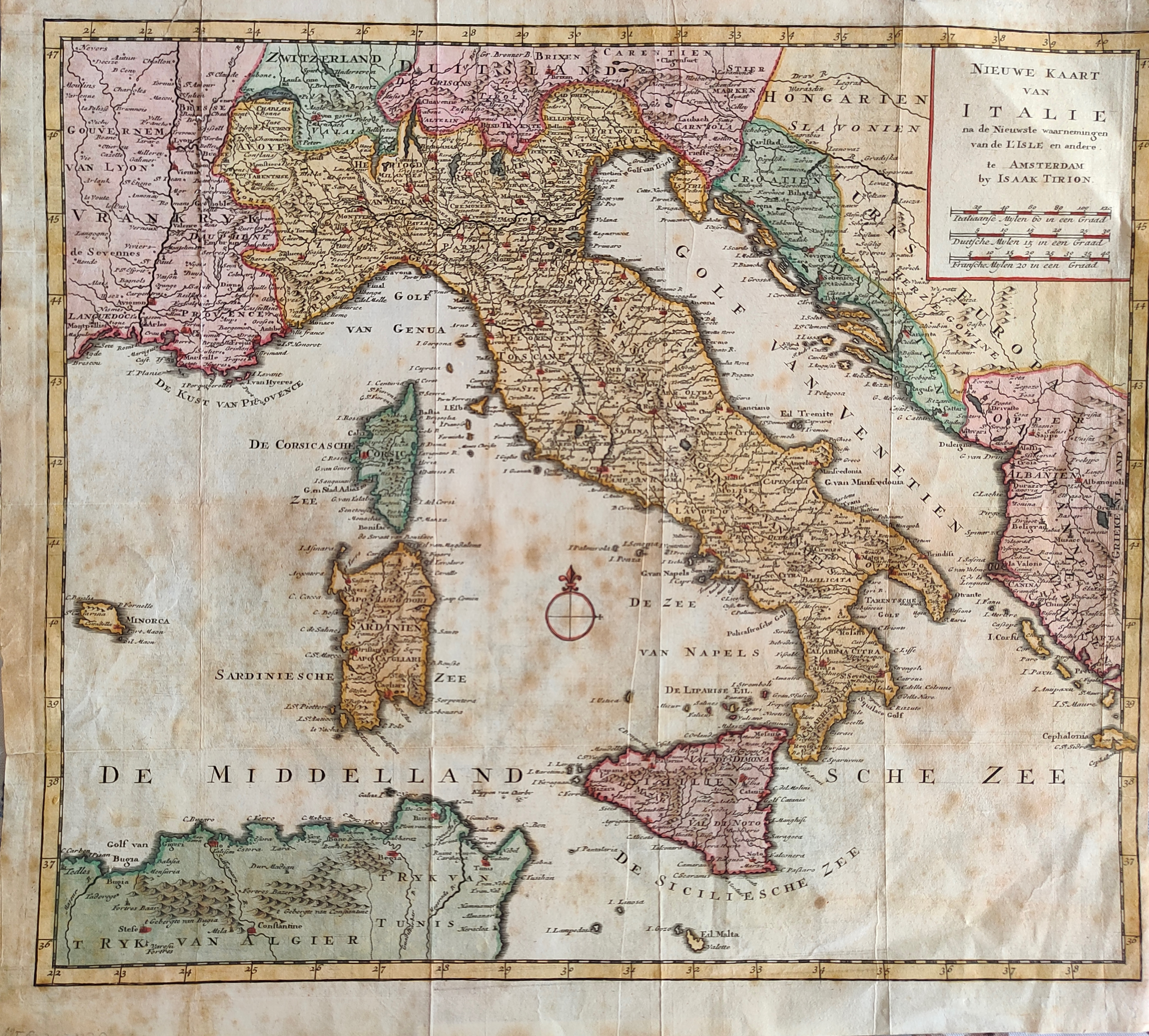
Map title
Nieuwe kaart van Italie
Author
Tirion
Location shown in map
Italy
Edition date
1744
Edition place
Amsterdam
Editor
Atlas
Hand-Atlas
Price
175 Euro
State
[mint/EXCELLENT/very good/good/fair/mediocre/poor]
Color
Old colors
Verso
Blank
Size
Plate: cm (39 x 33) inches (15.35 x 12.99) Paper: cm (40 x 37) inches (15.75 x 14.57)
Technique
Copper engraving
Note
Reference
Wiki
Here for more info
In stock
Available
Info
info@thetreasuremaps.com
Code
#1307
×
![Nieuwe kaart van Italie by Tirion, Italy, 1744]()
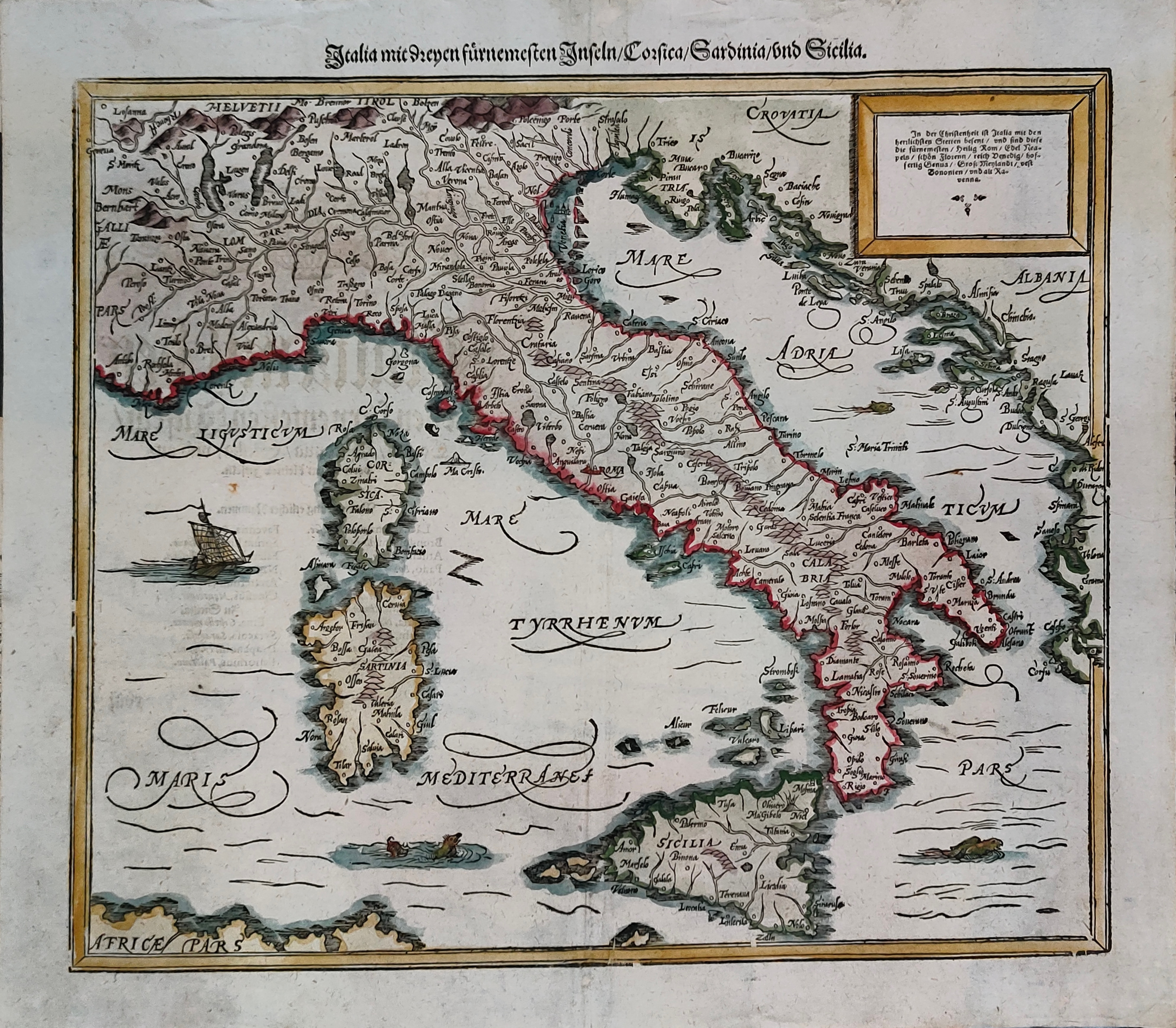
Map title
Italia mit Dreyen Furnemesten Inseln
Author
Munster
Location shown in map
Italy
Edition date
Circa 1628
Edition place
Basel
Editor
Henrich Petri
Atlas
Cosmographia Universalis
Price
450 Euro
State
[mint/EXCELLENT/very good/good/fair/mediocre/poor]
Color
Old colors
Verso
German text
Size
Plate: cm (37 x 30) inches (14.57 x 11.81) Paper: cm (41 x 36) inches (16.14 x 14.17)
Technique
Woodcut
Note
Reference
R.Borri L'Italia nelle antiche carte pag.50
Wiki
Here for more info
In stock
Available
Info
info@thetreasuremaps.com
Code
#1301
×
![Italia mit Dreyen Furnemesten Inseln by Munster, Italy, Circa 1628]()