News
Map title
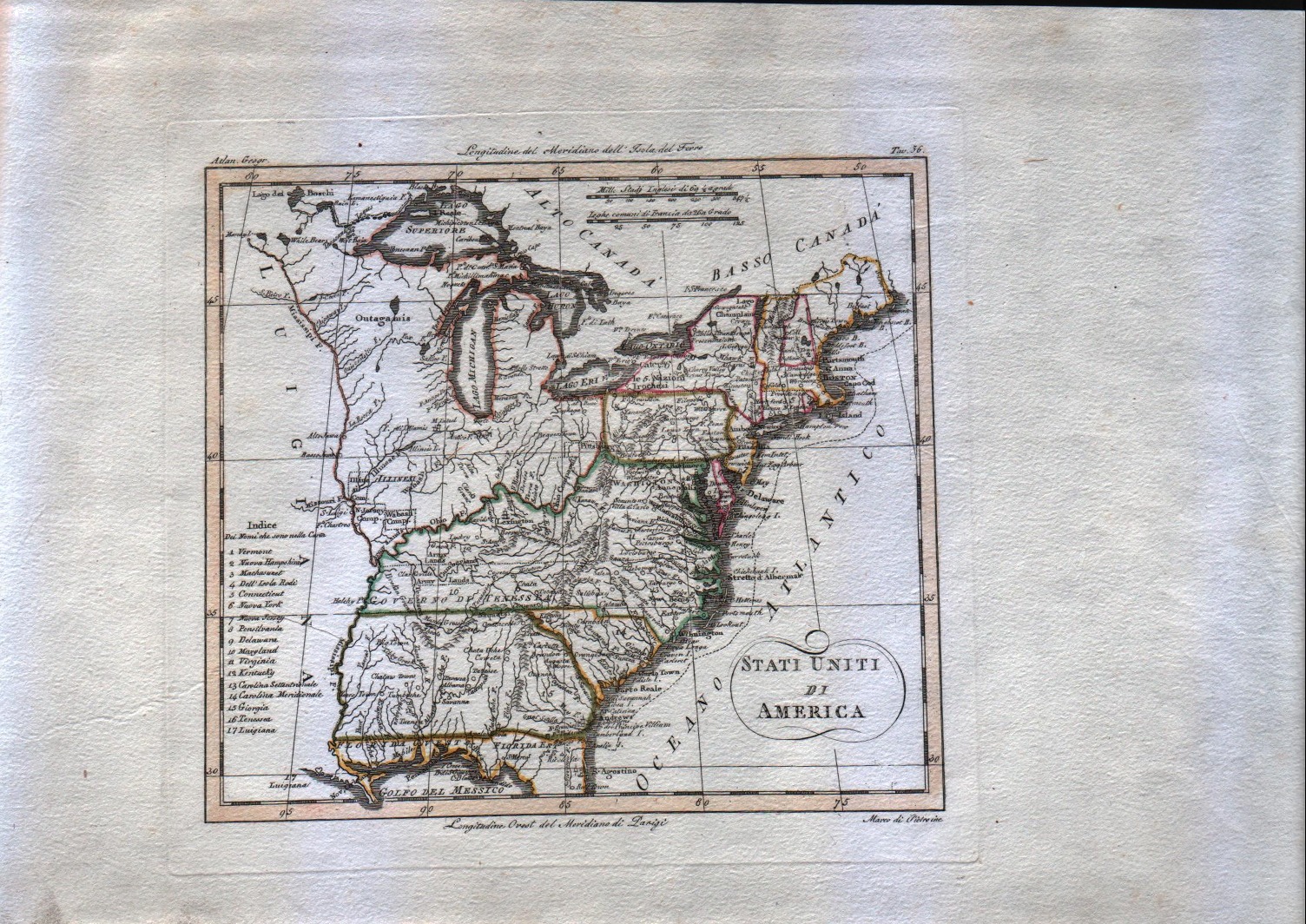
Stati uniti di America
Author
Unknown
Location shown in map
--
Edition date
1795
Edition place
Venice
Editor
--
Atlas
Compendio di geografia di Guthrie.
Price
125 Euro
State
[mint/EXCELLENT/very good/good/fair/mediocre/poor]
Color
Old outlined
Verso
Blank
Size
Plate: cm (20.3 x 17.8) inches (7.99 x 7.01) Paper: cm (20.3 x 17.8) inches (7.99 x 7.01)
Technique
Copper engraving
Note
This map shows the United States before the aquisition of Florida.
Reference
--
Wiki
Here for more info
In stock
Available
Info
info@thetreasuremaps.com
Code
#0083
×
![Stati uniti di America by Unknown, --, 1795]()
Map title
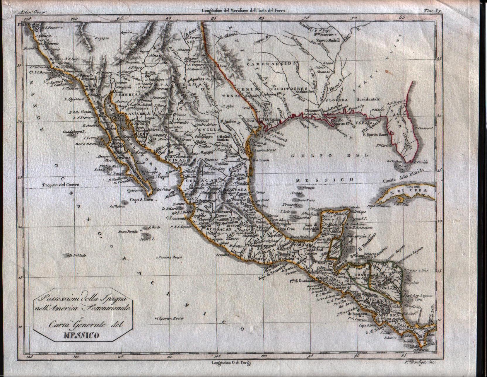
Possessioni della Spagna nell'america Settentrionale e Carta Generale del Messico
Author
Unknown
Location shown in map
South USA and Mexico
Edition date
1807
Edition place
Milan
Editor
--
Atlas
Barbiellini Atlante delle geografica antica e moderna
Price
125 Euro
State
[mint/EXCELLENT/very good/good/fair/mediocre/poor]
Color
Old outlined
Verso
Blank
Size
Plate: cm (24.8 x 19.7) inches (9.76 x 7.76) Paper: cm (27.9 x 22.9) inches (10.98 x 9.02)
Technique
Copper engraving
Note
Map of the Texas, Mexico, Upper California, Louisiana Territory and Florida. The cartography is certainly pre-1810, naming East and West Florida, showing a pre-Louisiana Purchase Louisiana and very early placenames in the Southwest, most notably Pimeria, Bagiopas, and Quivira, names which would disappear from the map within a few years. Another noteworthy feature is the listing of the Missions in Upper California, which do not generally appear in atlas maps of the period. Nice detail in Texas, including the appearance of the actual name Texas, another unusual early feature. A number of forts and Indian Tribes located. An interesting early map of the region.
Reference
--
Wiki
Here for more info
In stock
Available
Info
info@thetreasuremaps.com
Code
#0084
×
![Possessioni della Spagna nell'america Settentrionale e Carta Generale del Messico by Unknown, South USA and Mexico , 1807]()
Map title
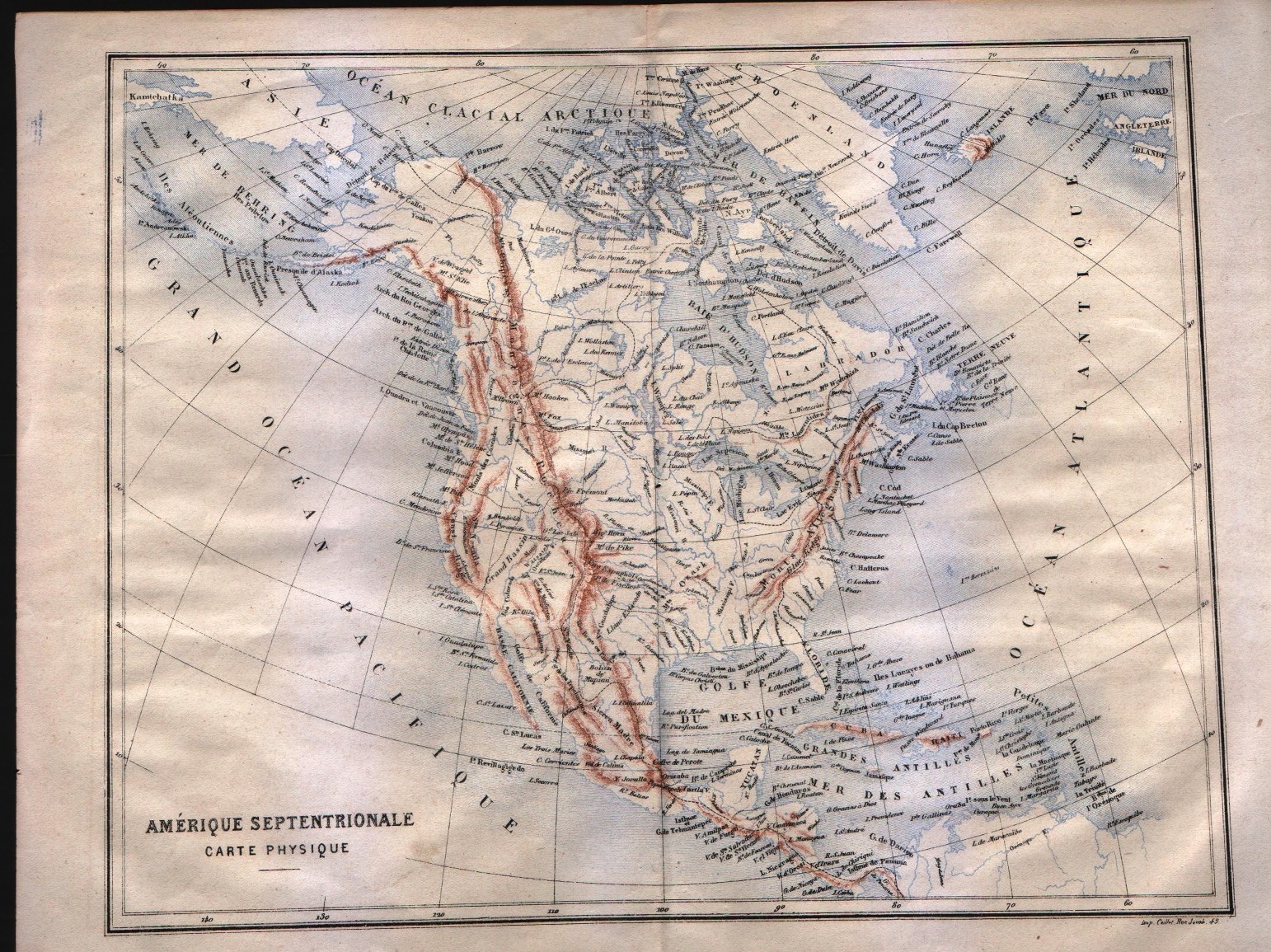
Carte de l'Amerique Septentrionale
Author
Delamarche
Location shown in map
USA
Edition date
1844
Edition place
Paris
Editor
--
Atlas
?? - Delamarche
Price
50 Euro
State
[mint/EXCELLENT/very good/good/fair/mediocre/poor]
Color
Old outlined
Verso
Blank
Size
Plate: cm (29.2 x 43.2) inches (11.5 x 17.01) Paper: cm (33 x 48.3) inches (12.99 x 19.02)
Technique
Copper engraving
Note
--
Reference
--
Wiki
Here for more info
In stock
Available
Info
info@thetreasuremaps.com
Code
#0087
×
![Carte de l'Amerique Septentrionale by Delamarche, USA , 1844]()
Map title
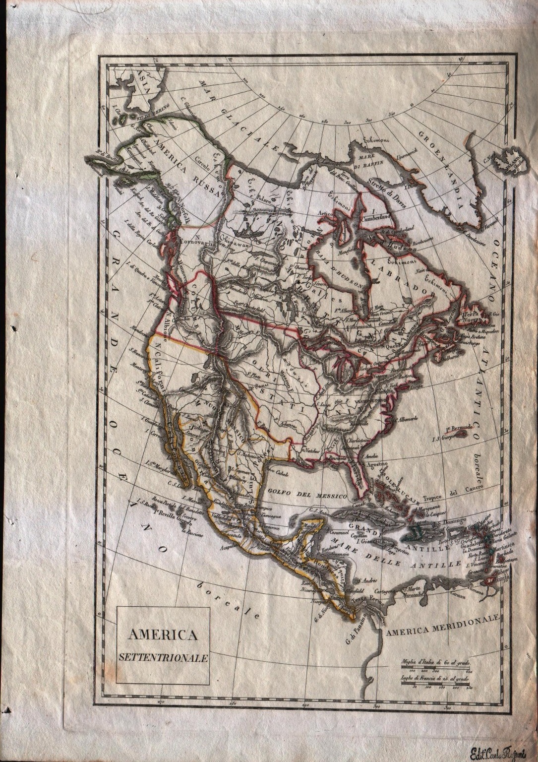
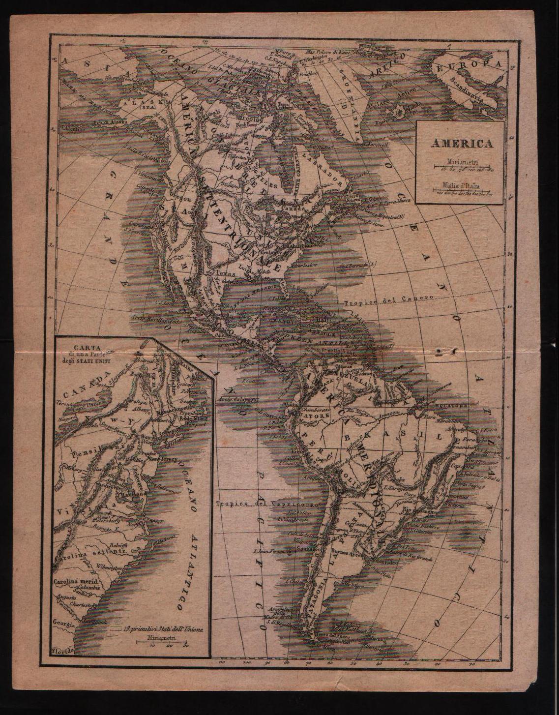
America Settentrionale
Author
Unknown
Location shown in map
North America
Edition date
1822
Edition place
Milan
Editor
--
Atlas
Printed by Carlo Rossari from an unknown atlas.
Price
125 Euro
State
[mint/excellent/very good/GOOD/fair/mediocre/poor] It has a small hole in the center.
Color
Old outlined
Verso
Blank
Size
Plate: cm (20.3 x 31.8) inches (7.99 x 12.52) Paper: cm (38.1 x 26.7) inches (15 x 10.51)
Technique
Copper engraving
Note
Italian map of North America. Texas is still part of Mexico. Note the Columbia borders.
Reference
--
Wiki
Here for more info
In stock
Available
Info
info@thetreasuremaps.com
Code
#0089
×
![America Settentrionale by Unknown, North America, 1822]()
Map title
America
Author
Unknown
Location shown in map
America
Edition date
Circa 1880
Edition place
--
Editor
--
Atlas
--
Price
50 Euro
State
[mint/excellent/VERY GOOD/good/fair/mediocre/poor]
Color
Uncoloured
Verso
Blank
Size
Plate: cm (16.5 x 21.6) inches (6.5 x 8.5) Paper: cm (17.8 x 22.9) inches (7.01 x 9.02)
Technique
Copper engraving
Note
No particular notes for this maps
Reference
--
Wiki
Here for more info
In stock
Available
Info
info@thetreasuremaps.com
Code
#0090
America
Author
Unknown
Location shown in map
America
Edition date
Circa 1880
Edition place
--
Editor
--
Atlas
--
Price
50 Euro
State
[mint/excellent/VERY GOOD/good/fair/mediocre/poor]
Color
Uncoloured
Verso
Blank
Size
Plate: cm (16.5 x 21.6) inches (6.5 x 8.5) Paper: cm (17.8 x 22.9) inches (7.01 x 9.02)
Technique
Copper engraving
Note
No particular notes for this maps
Reference
--
Wiki
Here for more info
In stock
Available
Info
info@thetreasuremaps.com
Code
#0090
×
![America by Unknown, America, Circa 1880]()
Map title
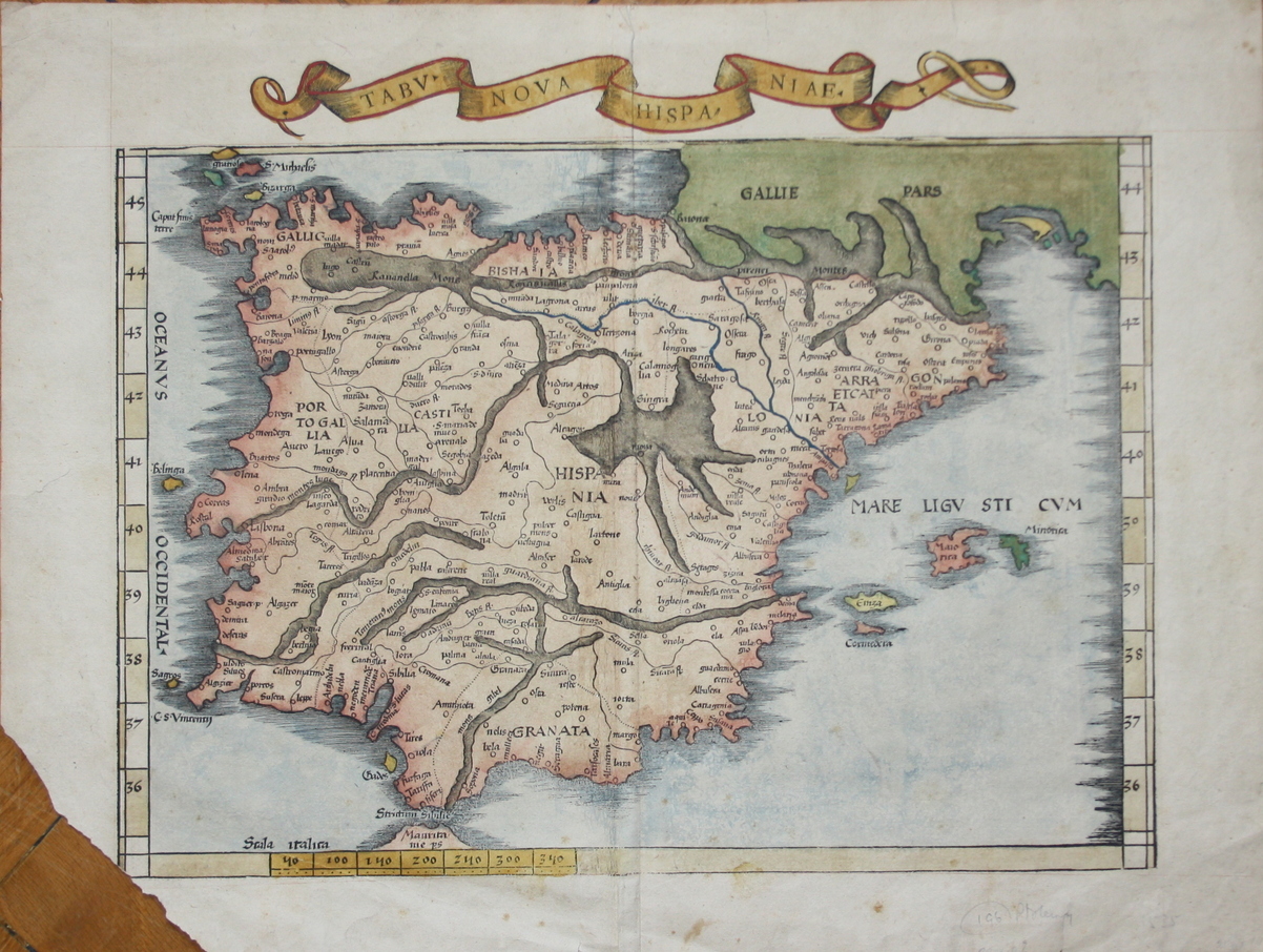
Tabv Nova Hispaniae
Author
Fries
Location shown in map
Spain
Edition date
1535
Edition place
Lyon
Editor
Melchior and Gaspar Trechsel
Atlas
Ptolemy's Geographia
Price
700 Euro
State
[mint/EXCELLENT/very good/good/fair/mediocre/poor] repaired
Color
Recent color
Verso
Blank
Size
Plate: cm (41.9 x 30.5) inches (16.5 x 12.01) Paper: cm (53.3 x 39.4) inches (20.98 x 15.51)
Technique
Woodcut
Note
Missing bottom left corner
Reference
--
Wiki
Here for more info
In stock
Available
Info
info@thetreasuremaps.com
Code
#0091
×
![Tabv Nova Hispaniae by Fries, Spain, 1535]()
Map title
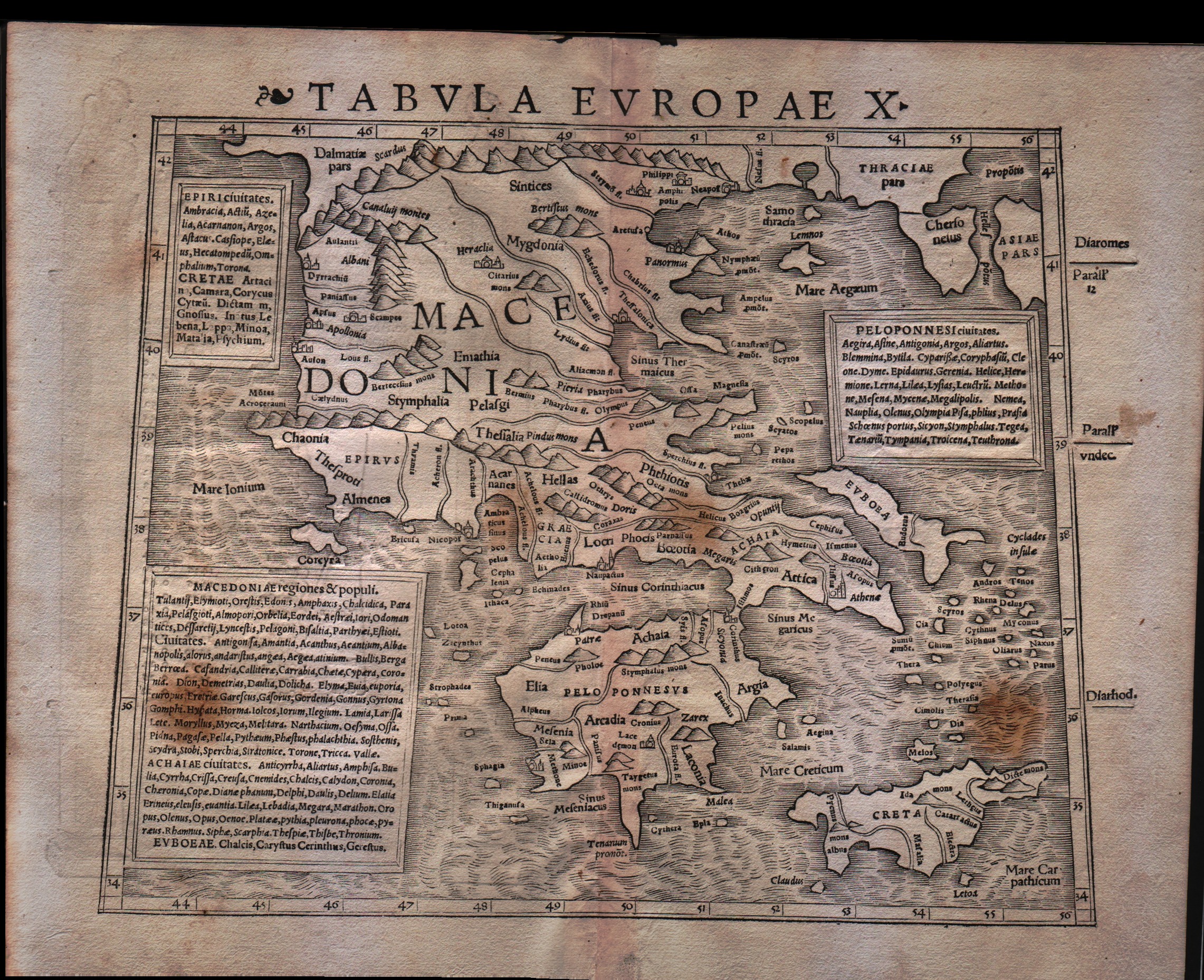
Tabula Europae X
Author
Munster
Location shown in map
Greece
Edition date
1540
Edition place
Basel
Editor
Henrich Petri
Atlas
Geographia
Price
300 Euro
State
[mint/EXCELLENT/very good/good/fair/mediocre/poor]
Color
Black/white
Verso
Latin text pag.12
Size
Plate: cm (31.8 x 25.4) inches (12.52 x 10) Paper: cm (38.1 x 30.5) inches (15 x 12.01)
Technique
Woodcut
Note
No particular notes for this maps
Reference
--
Wiki
Here for more info
In stock
Available
Info
info@thetreasuremaps.com
Code
#0093
×
![Tabula Europae X by Munster, Greece, 1540]()
Map title
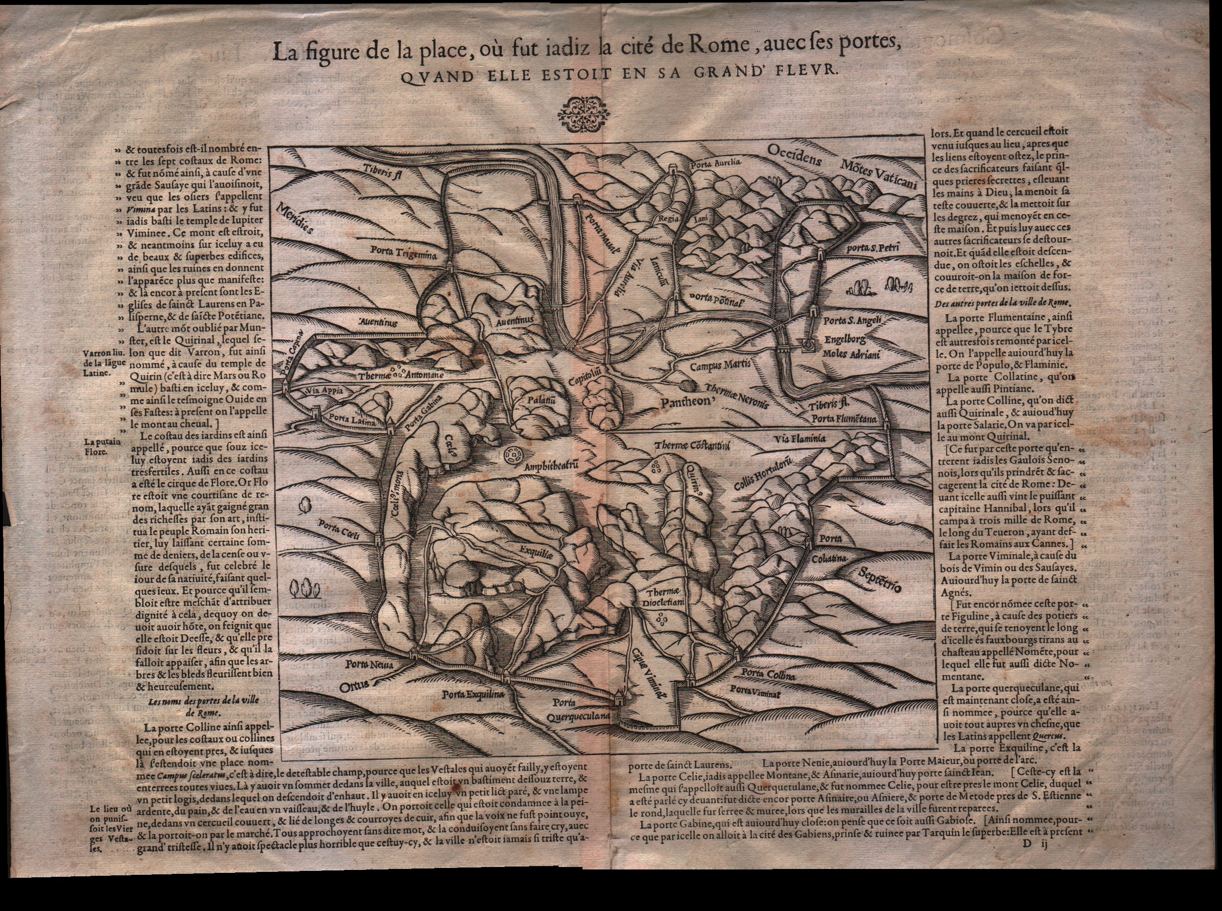
La figure de la place de Rome...
Author
Munster
Location shown in map
Rome
Edition date
1550
Edition place
Basel
Editor
Henrich Petri
Atlas
Cosmographia Universalis
Price
200 Euro
State
[mint/EXCELLENT/very good/good/fair/mediocre/poor]
Color
Black/white
Verso
French text pag.550
Size
Plate: cm (22.9 x 21.6) inches (9.02 x 8.5) Paper: cm (41.9 x 34.3) inches (16.5 x 13.5)
Technique
Woodcut
Note
No particular notes for this maps
Reference
--
Wiki
Here for more info
In stock
Available
Info
info@thetreasuremaps.com
Code
#0095
×
![La figure de la place de Rome... by Munster, Rome, 1550]()
Map title
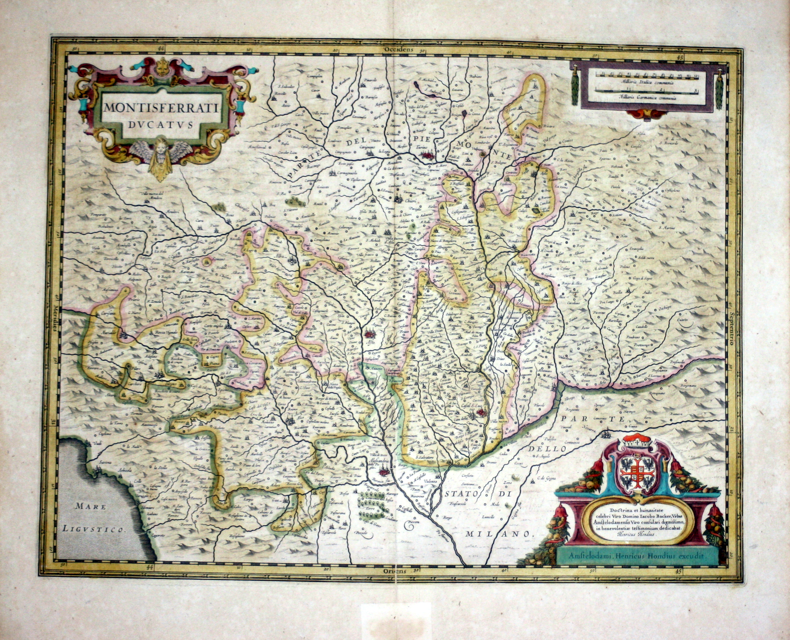
Montisferrati Ducatus
Author
Hondius
Location shown in map
Piedmont & Liguria, North west Italy
Edition date
1630
Edition place
Amsterdam
Editor
--
Atlas
Atlas Novus
Price
300 Euro
State
[mint/EXCELLENT/very good/good/fair/mediocre/poor]
Color
Old color
Verso
French text
Size
Plate: cm (48.3 x 36.8) inches (19.02 x 14.49) Paper: cm (54.6 x 47) inches (21.5 x 18.5)
Technique
Copper engraving
Note
No particular notes for this maps
Reference
--
Wiki
Here for more info
In stock
Available
Info
info@thetreasuremaps.com
Code
#0096
×
![Montisferrati Ducatus by Hondius, Piedmont & Liguria, North west Italy, 1630]()
Map title
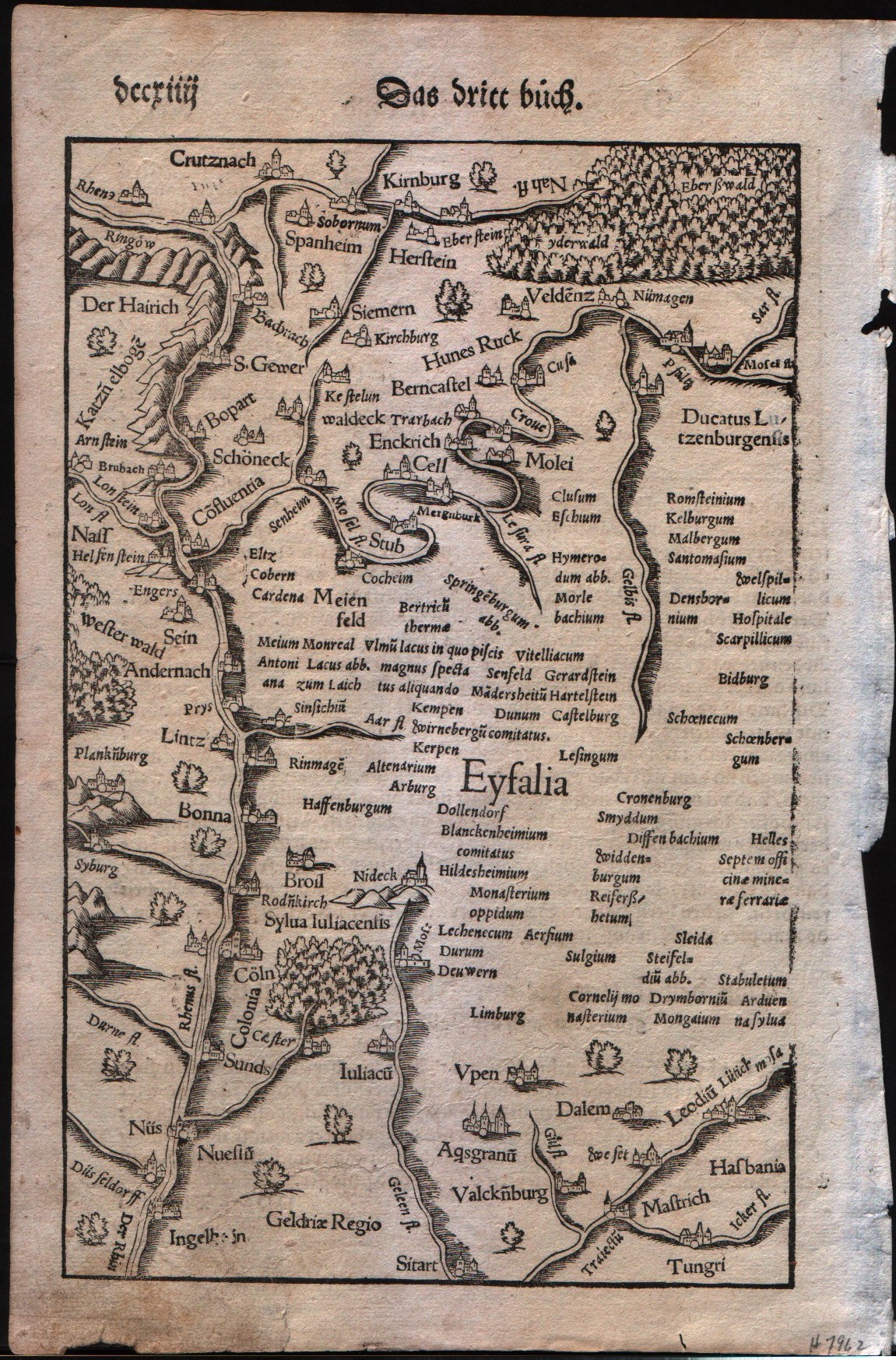
German Rhine
Author
Munster
Location shown in map
The Rhine Valley in Germany
Edition date
1560
Edition place
???
Editor
Henrich Petri
Atlas
Cosmographia Universalis
Price
Please ask: info@thetreasuremaps.com
State
[mint/EXCELLENT/very good/good/fair/mediocre/poor]
Color
Black/white
Verso
German text
Size
Plate: cm (16.5 x 25.4) inches (6.5 x 10) Paper: cm (19 x 29.2) inches (7.48 x 11.5)
Technique
Woodcut
Note
No particular notes for this maps
Reference
--
Wiki
Here for more info
In stock
Available
Info
info@thetreasuremaps.com
Code
#0097
×
![German Rhine by Munster, The Rhine Valley in Germany, 1560]()
Map title
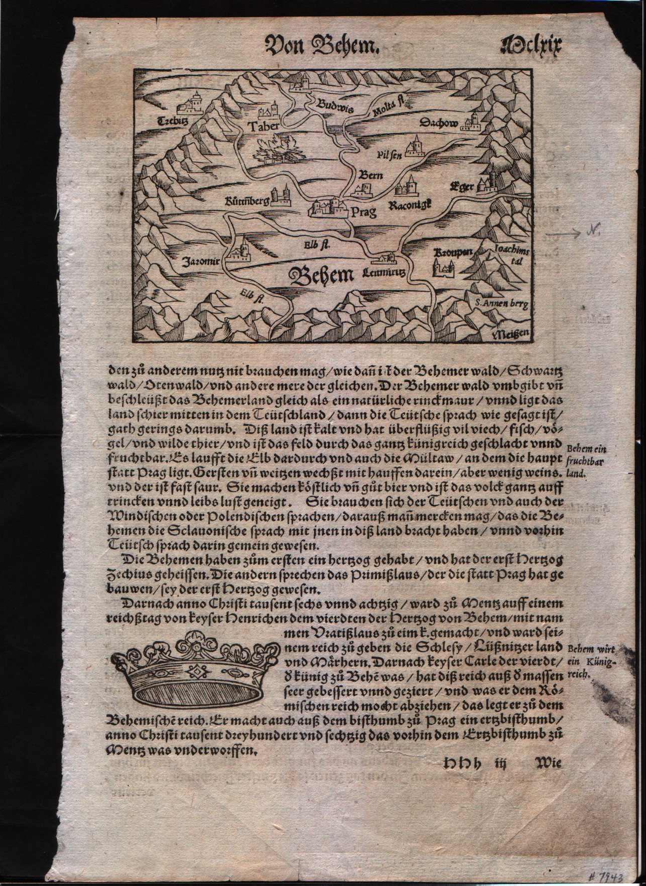
Prag area
Author
Munster
Location shown in map
Prag area
Edition date
1560
Edition place
???
Editor
Henrich Petri
Atlas
Cosmographia Universalis
Price
Please ask: info@thetreasuremaps.com
State
[mint/EXCELLENT/very good/good/fair/mediocre/poor]
Color
Black/white
Verso
German text
Size
Plate: cm (8.9 x 14) inches (3.5 x 5.51) Paper: cm (44.4 x 29.2) inches (17.48 x 11.5)
Technique
Woodcut
Note
No particular notes for this maps
Reference
--
Wiki
Here for more info
In stock
Available
Info
info@thetreasuremaps.com
Code
#0098
Prag area
Author
Munster
Location shown in map
Prag area
Edition date
1560
Edition place
???
Editor
Henrich Petri
Atlas
Cosmographia Universalis
Price
Please ask: info@thetreasuremaps.com
State
[mint/EXCELLENT/very good/good/fair/mediocre/poor]
Color
Black/white
Verso
German text
Size
Plate: cm (8.9 x 14) inches (3.5 x 5.51) Paper: cm (44.4 x 29.2) inches (17.48 x 11.5)
Technique
Woodcut
Note
No particular notes for this maps
Reference
--
Wiki
Here for more info
In stock
Available
Info
info@thetreasuremaps.com
Code
#0098
×
![Prag area by Munster, Prag area, 1560]()
Map title
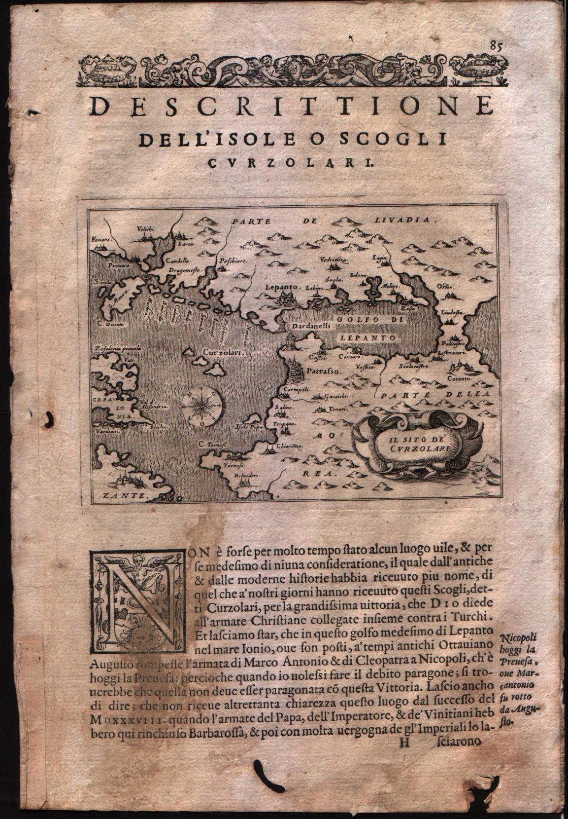
Descrittione dell'isole o scogli Curzolari
Author
Porcacchi
Location shown in map
Central Greece
Edition date
1576
Edition place
Venice
Editor
--
Atlas
L'Isole piu famose del mondo -- S. Galignani and G. Porro
Price
Please ask: info@thetreasuremaps.com
State
[mint/EXCELLENT/very good/good/fair/mediocre/poor]
Color
Black/white
Verso
Italian text pag.86
Size
Plate: cm (15.2 x 11.4) inches (5.98 x 4.49) Paper: cm (19 x 27.9) inches (7.48 x 10.98)
Technique
Copper engraving
Note
No particular notes for this maps
Reference
Genoa pubblic library "Civica Berio"
Wiki
Here for more info
In stock
Available
Info
info@thetreasuremaps.com
Code
#0099
×
![Descrittione dell'isole o scogli Curzolari by Porcacchi, Central Greece, 1576]()
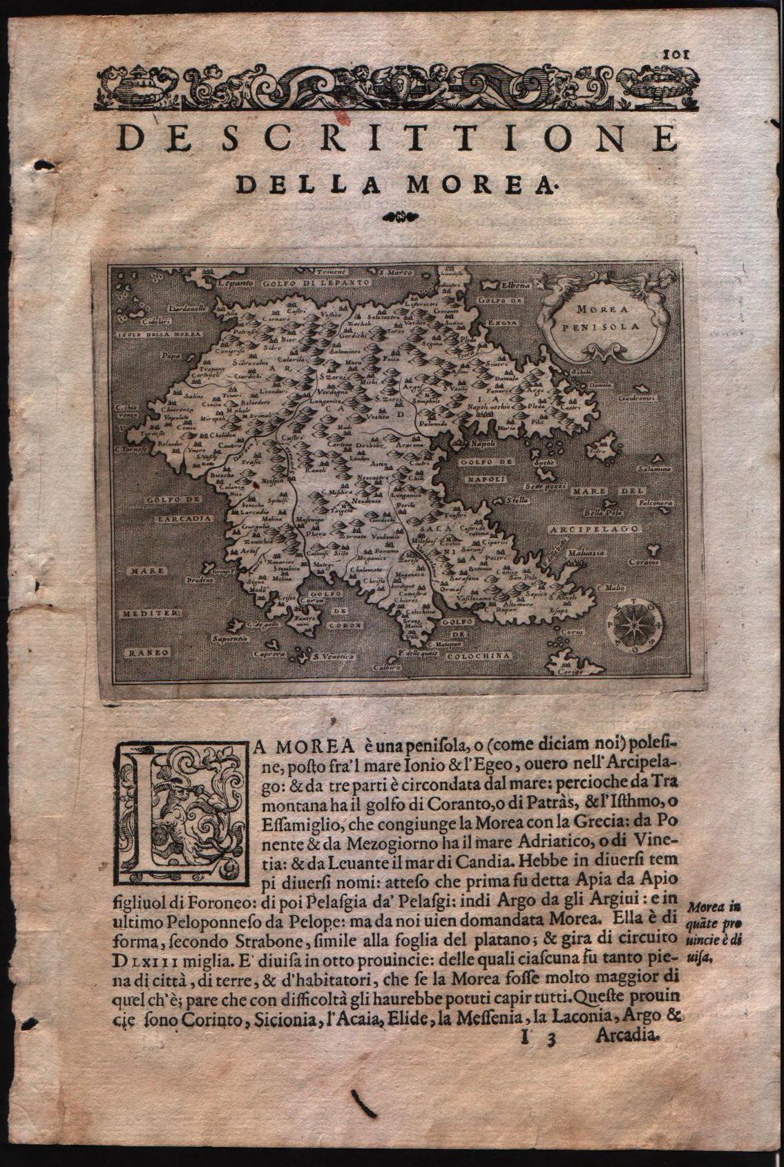
Map title
Descrittione della Morea
Author
Porcacchi
Location shown in map
South Greece
Edition date
1576
Edition place
Venice
Editor
--
Atlas
L'Isole piu famose del mondo -- S. Galignani and G. Porro
Price
Please ask: info@thetreasuremaps.com
State
[MINT/excellent/very good/good/fair/mediocre/poor]
Color
Black/white
Verso
Italian text pag.86
Size
Plate: cm (15.2 x 11.4) inches (5.98 x 4.49) Paper: cm (19 x 27.9) inches (7.48 x 10.98)
Technique
Copper engraving
Note
No particular notes for this maps
Reference
Genoa pubblic library "Civica Berio"
Wiki
Here for more info
In stock
Available
Info
info@thetreasuremaps.com
Code
#0100
×
![Descrittione della Morea by Porcacchi, South Greece, 1576]()
Map title
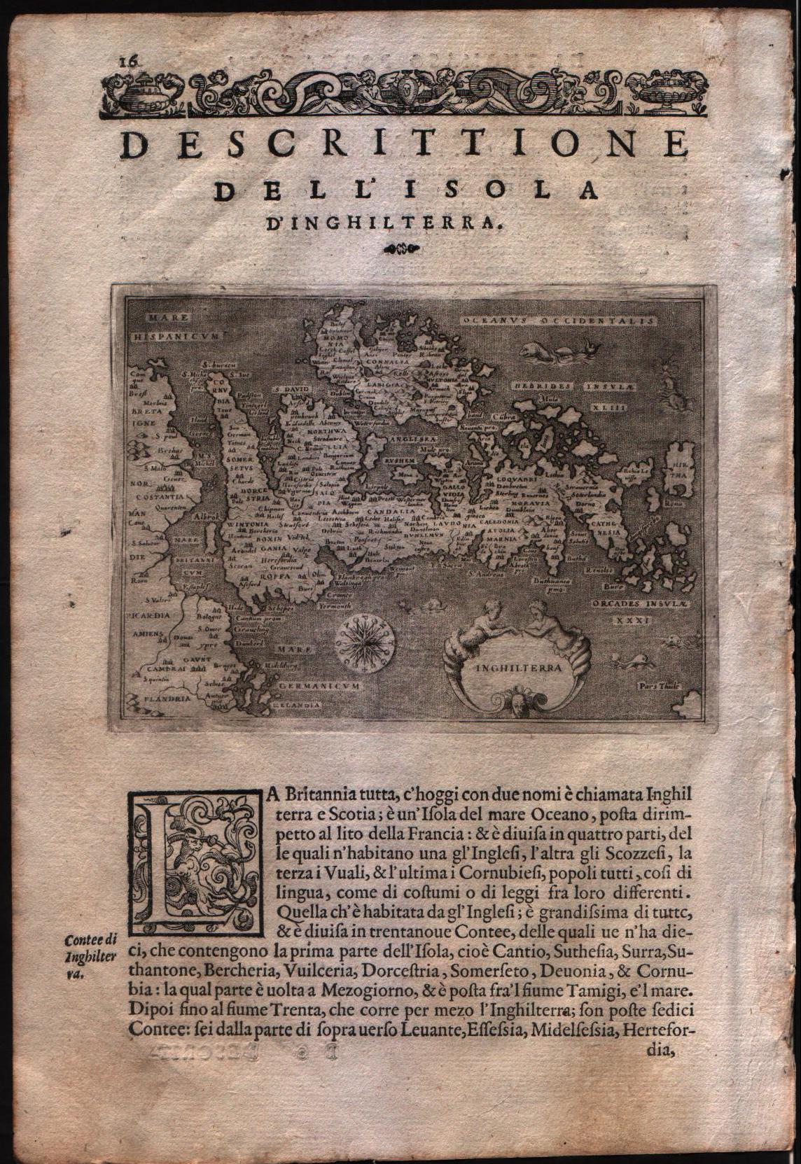
Descrittione dell'isola d'Inghilterra
Author
Porcacchi
Location shown in map
England
Edition date
1576
Edition place
Venice
Editor
--
Atlas
L'Isole piu famose del mondo -- S. Galignani and G. Porro
Price
Please ask: info@thetreasuremaps.com
State
[MINT/excellent/very good/good/fair/mediocre/poor]
Color
Black/white
Verso
Italian text pag.15
Size
Plate: cm (15.2 x 11.4) inches (5.98 x 4.49) Paper: cm (19 x 27.9) inches (7.48 x 10.98)
Technique
Copper engraving
Note
No particular notes for this maps
Reference
Genoa pubblic library "Civica Berio"
Wiki
Here for more info
In stock
Available
Info
info@thetreasuremaps.com
Code
#0101
×
![Descrittione dell'isola d'Inghilterra by Porcacchi, England, 1576]()
Map title
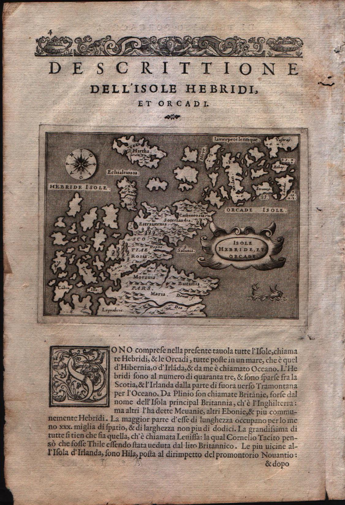
Descrittione dell'isole Hebridi et Orcadi
Author
Porcacchi
Location shown in map
Scottish islands - The Henrides and Orkneys
Edition date
1576
Edition place
Venice
Editor
--
Atlas
L'Isole piu famose del mondo -- S. Galignani and G. Porro
Price
Please ask: info@thetreasuremaps.com
State
[MINT/excellent/very good/good/fair/mediocre/poor]
Color
Black/white
Verso
Italian text pag.4
Size
Plate: cm (15.2 x 11.4) inches (5.98 x 4.49) Paper: cm (19 x 27.9) inches (7.48 x 10.98)
Technique
Copper engraving
Note
No particular notes for this maps
Reference
Genoa pubblic library "Civica Berio"
Wiki
Here for more info
In stock
Available
Info
info@thetreasuremaps.com
Code
#0103
×
![Descrittione dell'isole Hebridi et Orcadi by Porcacchi, Scottish islands - The Henrides and Orkneys, 1576]()
Map title
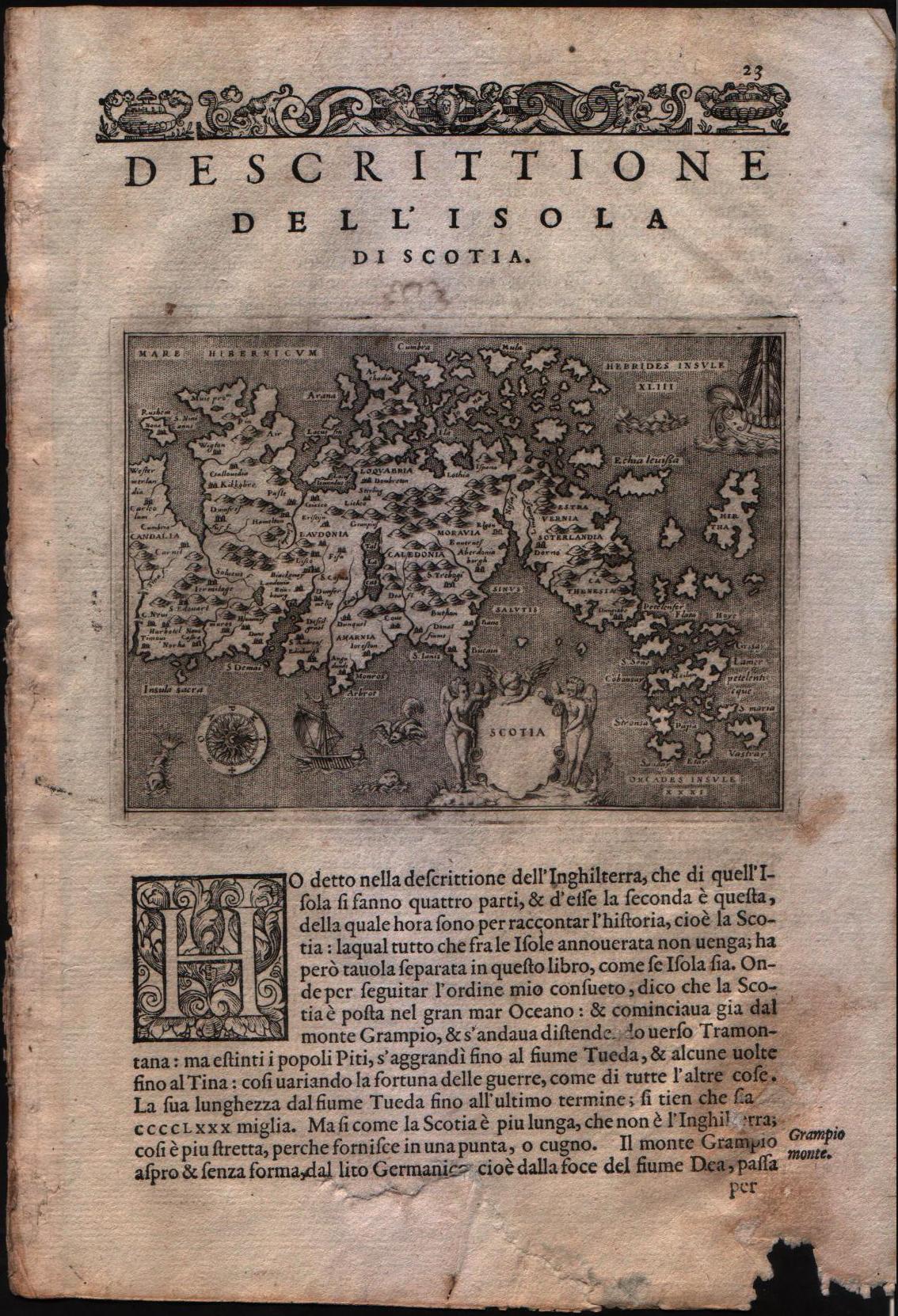
Descrittione dell'isola di Scotia
Author
Porcacchi
Location shown in map
Scotland
Edition date
1576
Edition place
Venice
Editor
--
Atlas
L'Isole piu famose del mondo -- S. Galignani and G. Porro
Price
Please ask: info@thetreasuremaps.com
State
[MINT/excellent/very good/good/fair/mediocre/poor]
Color
Black/white
Verso
Italian text pag.23
Size
Plate: cm (15.2 x 11.4) inches (5.98 x 4.49) Paper: cm (19 x 27.9) inches (7.48 x 10.98)
Technique
Copper engraving
Note
No particular notes for this maps
Reference
Genoa pubblic library "Civica Berio"
Wiki
Here for more info
In stock
Available
Info
info@thetreasuremaps.com
Code
#0104
×
![Descrittione dell'isola di Scotia by Porcacchi, Scotland, 1576]()
Map title
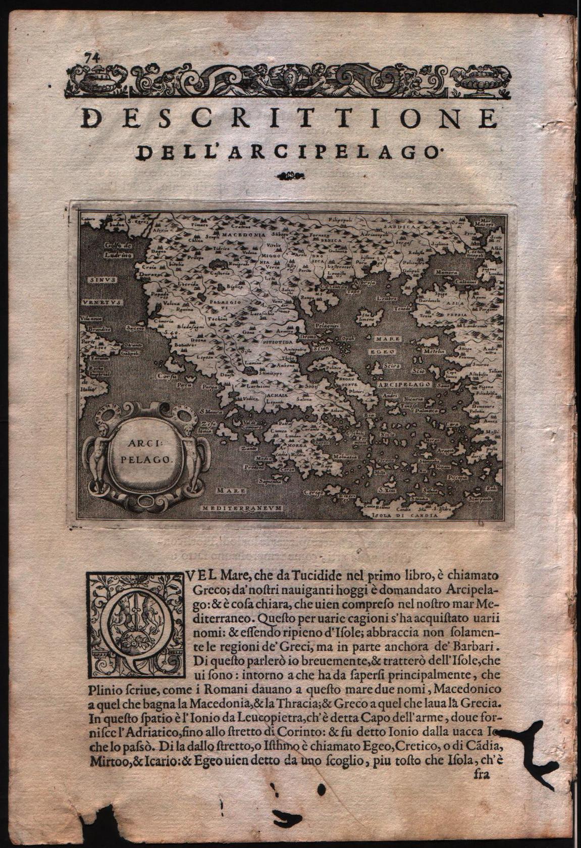
Descrittione dell'arcipelago
Author
Porcacchi
Location shown in map
Greece
Edition date
1576
Edition place
Venice
Editor
--
Atlas
L'Isole piu famose del mondo -- S. Galignani and G. Porro
Price
Please ask: info@thetreasuremaps.com
State
[MINT/excellent/very good/good/fair/mediocre/poor]
Color
Black/white
Verso
Italian text pag.74
Size
Plate: cm (15.2 x 11.4) inches (5.98 x 4.49) Paper: cm (19 x 29.2) inches (7.48 x 11.5)
Technique
Copper engraving
Note
No particular notes for this maps
Reference
Genoa pubblic library "Civica Berio"
Wiki
Here for more info
In stock
Available
Info
info@thetreasuremaps.com
Code
#0105
×
![Descrittione dell'arcipelago by Porcacchi, Greece, 1576]()
Map title
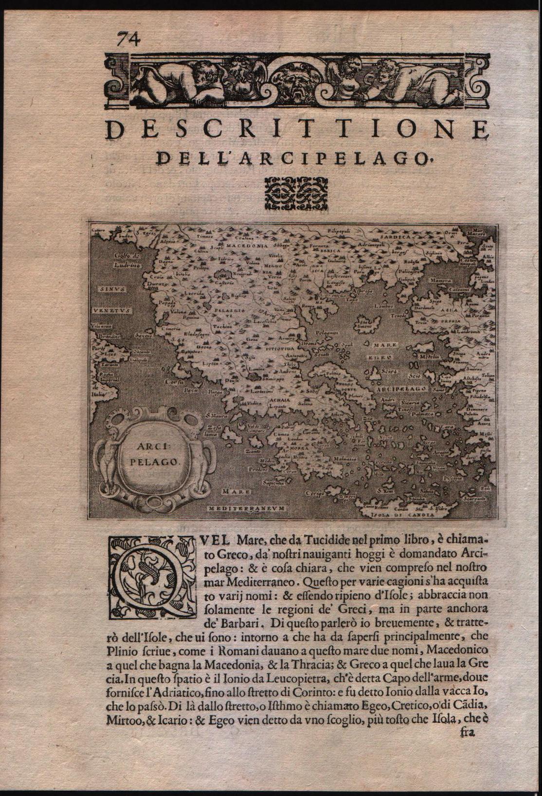
Descrittione dell'arcipelago
Author
Porcacchi
Location shown in map
Greece
Edition date
1602
Edition place
Venice
Editor
--
Atlas
L'Isole piu famose del mondo -- S. Galignani and G. Porro
Price
200 Euro
State
[MINT/excellent/very good/good/fair/mediocre/poor]
Color
Black/white
Verso
Italian text pag.74
Size
Plate: cm (15.2 x 11.4) inches (5.98 x 4.49) Paper: cm (19 x 29.2) inches (7.48 x 11.5)
Technique
Copper engraving
Note
No particular notes for this maps
Reference
--
Wiki
Here for more info
In stock
Available
Info
info@thetreasuremaps.com
Code
#0106
×
![Descrittione dell'arcipelago by Porcacchi, Greece, 1602]()
Map title
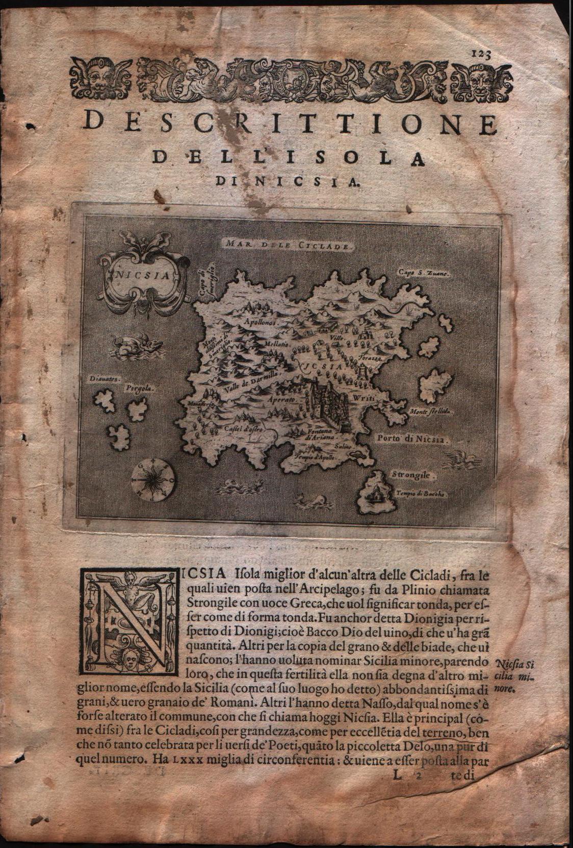
Descrittione dell'isola di Nicsia
Author
Porcacchi
Location shown in map
Naxos island
Edition date
1576
Edition place
Venice
Editor
--
Atlas
L'Isole piu famose del mondo -- S. Galignani and G. Porro
Price
Please ask: info@thetreasuremaps.com
State
[mint/excellent/VERY GOOD/good/fair/mediocre/poor]
Color
Black/white
Verso
Italian text pag.124
Size
Plate: cm (15.2 x 11.4) inches (5.98 x 4.49) Paper: cm (19 x 29.2) inches (7.48 x 11.5)
Technique
Copper engraving
Note
No particular notes for this maps
Reference
Genoa pubblic library "Civica Berio"
Wiki
Here for more info
In stock
Available
Info
info@thetreasuremaps.com
Code
#0107
×
![Descrittione dell'isola di Nicsia by Porcacchi, Naxos island, 1576]()
Map title
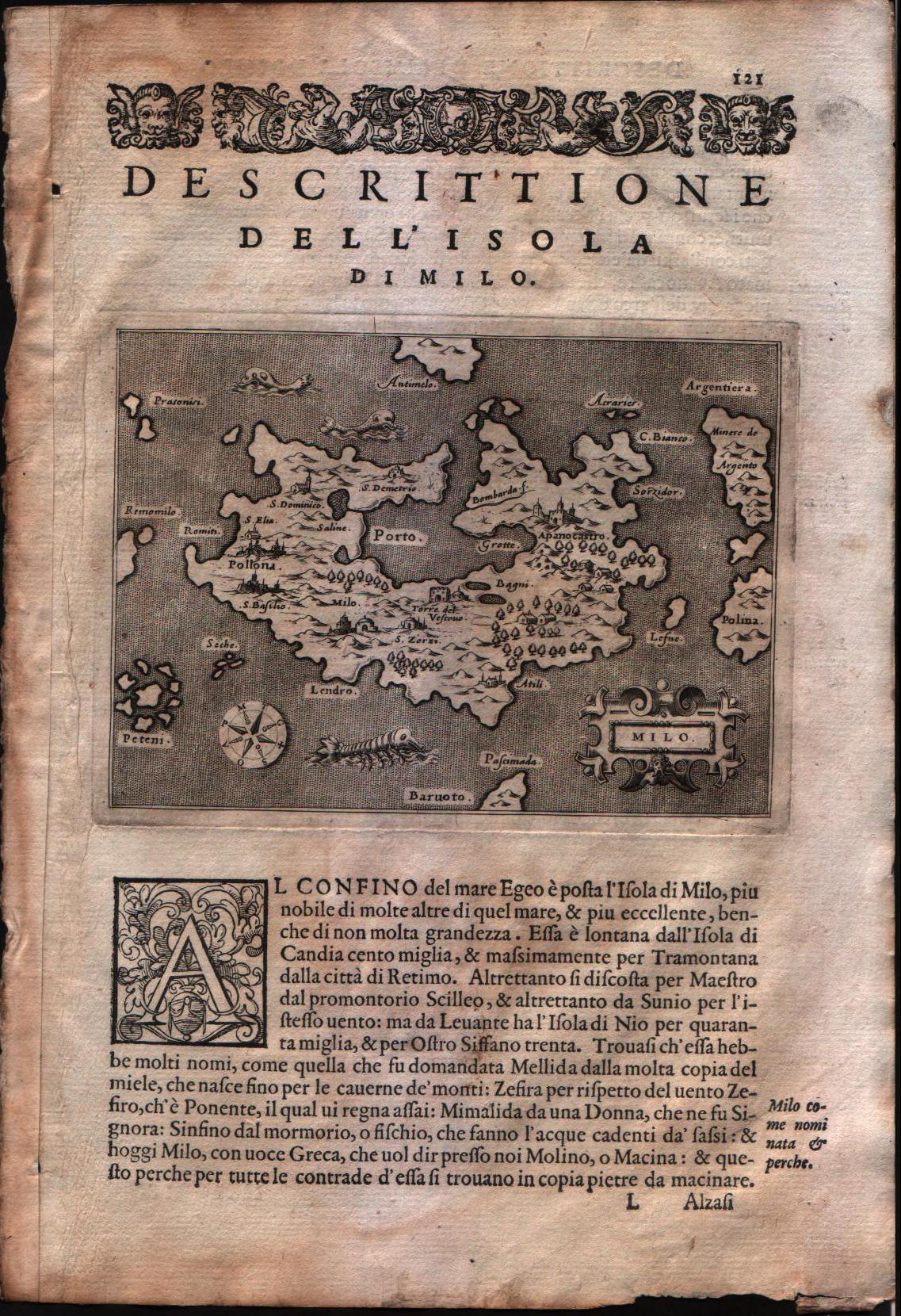
Descrittione dell'isola di Milo
Author
Porcacchi
Location shown in map
Milo island
Edition date
1576
Edition place
Venice
Editor
--
Atlas
L'Isole piu famose del mondo -- S. Galignani and G. Porro
Price
Please ask: info@thetreasuremaps.com
State
[mint/EXCELLENT/very good/good/fair/mediocre/poor]
Color
Black/white
Verso
Italian text pag.122
Size
Plate: cm (15.2 x 11.4) inches (5.98 x 4.49) Paper: cm (19 x 29.2) inches (7.48 x 11.5)
Technique
Copper engraving
Note
No particular notes for this maps
Reference
Genoa pubblic library "Civica Berio"
Wiki
Here for more info
In stock
Available
Info
info@thetreasuremaps.com
Code
#0108
×
![Descrittione dell'isola di Milo by Porcacchi, Milo island, 1576]()