News
Map title
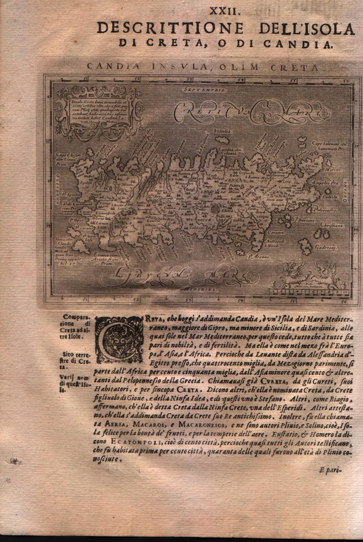
Descrittione dell'isola di Creta, o di Candia
Author
Magini
Location shown in map
Crete island
Edition date
1621
Edition place
Padova
Editor
Paolo and Francesco Galignani
Atlas
Geografia di Claudio Tolomeo -- Giovanni Antonio Magini
Price
200 Euro
State
[MINT/excellent/very good/good/fair/mediocre/poor]
Color
Black/white
Verso
Italian text pag 128
Size
Plate: cm (12.7 x 17.8) inches (5 x 7.01) Paper: cm (20.3 x 30.5) inches (7.99 x 12.01)
Technique
Copper engraving
Note
No particular notes for this maps.
Reference
--
Wiki
Here for more info
In stock
Available
Info
info@thetreasuremaps.com
Code
#0131
×
![Descrittione dell'isola di Creta, o di Candia by Magini, Crete island, 1621]()
Map title
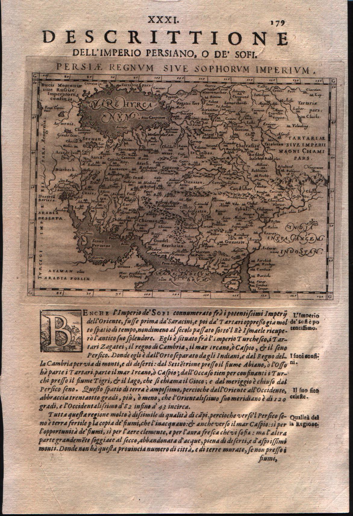
Descrittione dell'impero persiano o de' Sofri
Author
Magini
Location shown in map
Persia
Edition date
1621
Edition place
Padova
Editor
Paolo and Francesco Galignani
Atlas
Geografia di Claudio Tolomeo -- Giovanni Antonio Magini
Price
125 Euro
State
[MINT/excellent/very good/good/fair/mediocre/poor]
Color
Black/white
Verso
Italian text pag 179
Size
Plate: cm (12.7 x 17.8) inches (5 x 7.01) Paper: cm (20.3 x 30.5) inches (7.99 x 12.01)
Technique
Copper engraving
Note
No particular notes for this maps.
Reference
--
Wiki
Here for more info
In stock
Available
Info
info@thetreasuremaps.com
Code
#0132
×
![Descrittione dell'impero persiano o de' Sofri by Magini, Persia, 1621]()
Map title
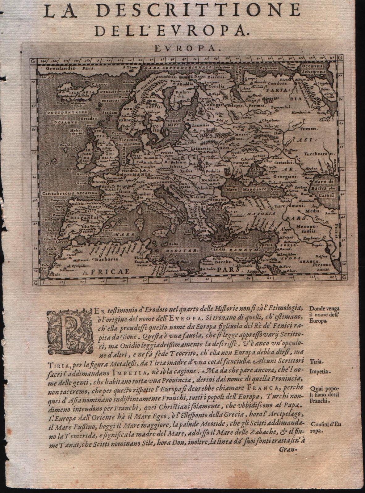
La descrittione dell'Europa
Author
Magini
Location shown in map
Europe
Edition date
1598
Edition place
Venice
Editor
Battista & Giorgio Galignani
Atlas
Geografia di Claudio Tolomeo -- Giovanni Antonio Magini
Price
300 Euro
State
[MINT/excellent/very good/good/fair/mediocre/poor]
Color
Black/white
Verso
Italian text pag.23
Size
Plate: cm (17.8 x 12.7) inches (7.01 x 5) Paper: cm (20.3 x 30.5) inches (7.99 x 12.01)
Technique
Copper engraving
Note
--
Reference
--
Wiki
Here for more info
In stock
Available
Info
info@thetreasuremaps.com
Code
#0133
×
![La descrittione dell'Europa by Magini, Europe, 1598]()
Map title
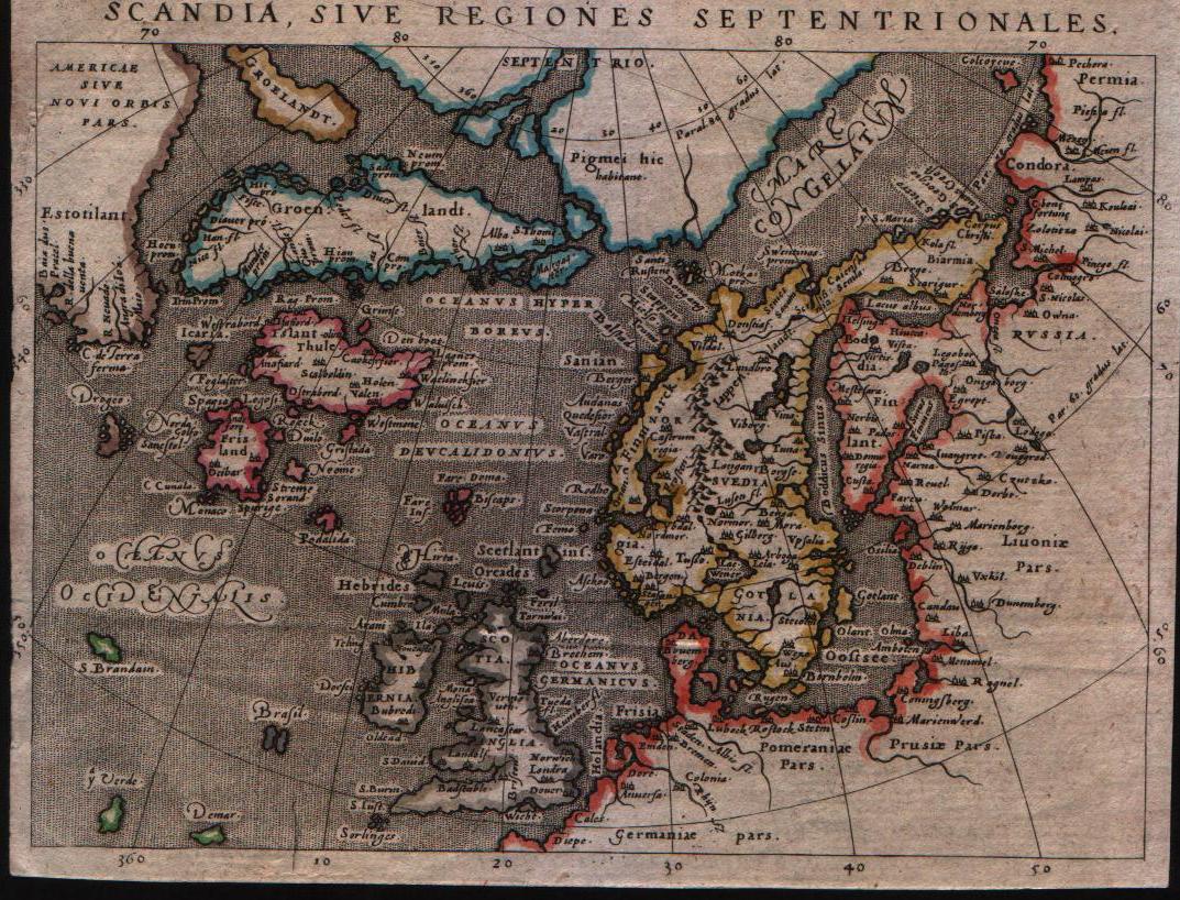
Scandia sive regiones septentrionales
Author
Magini
Location shown in map
North Europe
Edition date
1598
Edition place
Venice
Editor
Battista & Giorgio Galignani
Atlas
Geografia di Claudio Tolomeo -- Giovanni Antonio Magini
Price
300 Euro
State
[mint/excellent/VERY GOOD/good/fair/mediocre/poor]
Color
Old color
Verso
Italian text
Size
Plate: cm (14 x 17.8) inches (5.51 x 7.01) Paper: cm (14 x 17.8) inches (5.51 x 7.01)
Technique
Copper engraving
Note
--
Reference
--
Wiki
Here for more info
In stock
Available
Info
info@thetreasuremaps.com
Code
#0134
×
![Scandia sive regiones septentrionales by Magini, North Europe, 1598]()
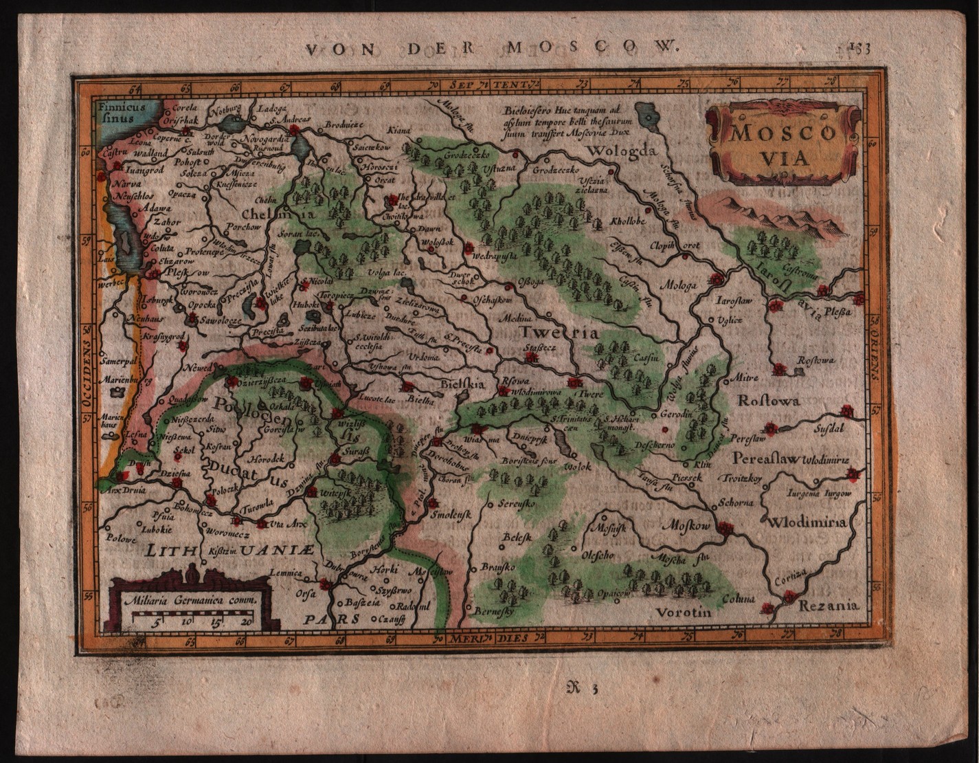
Map title
Moscovia
Author
Mercator
Location shown in map
Russia
Edition date
1635
Edition place
Amsterdam
Editor
Janssonius
Atlas
Altas Minor Gerardi Mercatoris
Price
100 Euro
State
[MINT/excellent/very good/good/fair/mediocre/poor]
Color
Later hand coloring.
Verso
German text
Size
Plate: cm (20.3 x 14) inches (7.99 x 5.51) Paper: cm (22.9 x 17.8) inches (9.02 x 7.01)
Technique
Copper engraving
Note
This map of Russia shows the regions of 'Chelmia', 'Wologda', 'Lithuanie' and 'Polocenis Ducatus' with the cities of Moscow.
Reference
--
Wiki
Here for more info
In stock
Available
Info
info@thetreasuremaps.com
Code
#0135
×
![Moscovia by Mercator, Russia, 1635]()
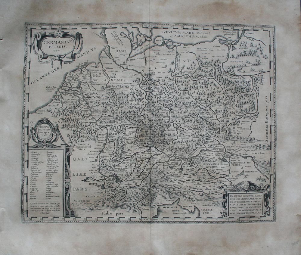
Map title
Germaniae veteris typus
Author
Blaeu
Location shown in map
Germany
Edition date
1630
Edition place
Amsterdam
Editor
--
Atlas
Appendix
Price
250 Euro
State
[mint/excellent/VERY GOOD/good/fair/mediocre/poor]
Color
Black/white
Verso
Latin text
Size
Plate: cm (48.3 x 35.6) inches (19.02 x 14.02) Paper: cm (58.4 x 50.8) inches (22.99 x 20)
Technique
Copper engraving
Note
Ancient Germany.
Reference
--
Wiki
Here for more info
In stock
Available
Info
info@thetreasuremaps.com
Code
#0137
×
![Germaniae veteris typus by Blaeu, Germany, 1630]()
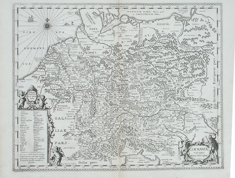
Map title
Germaniae veteris nova descriptio
Author
Jansson
Location shown in map
Germany
Edition date
1652
Edition place
Amsterdam
Editor
--
Atlas
Accuratissima orbis antiqui delineatio.
Price
250 Euro
State
[mint/excellent/VERY GOOD/good/fair/mediocre/poor]
Color
Black/white
Verso
Blank
Size
Plate: cm (47 x 36.8) inches (18.5 x 14.49) Paper: cm (54.6 x 45.7) inches (21.5 x 17.99)
Technique
Copper engraving
Note
Map based on Ortelius' map of ancient Germany.
Reference
--
Wiki
Here for more info
In stock
Available
Info
info@thetreasuremaps.com
Code
#0138
×
![Germaniae veteris nova descriptio by Jansson, Germany, 1652]()
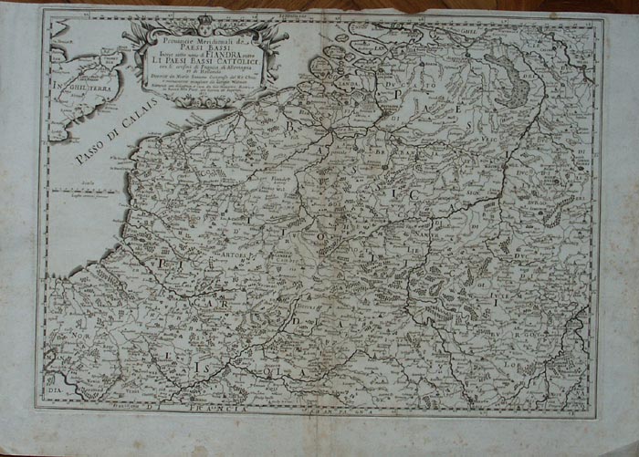
Map title
Provincie meridionali de Paesi Bassi intese sotto nome di Fiandra overo i Paesi Bassi cattolici
Author
Sanson
Location shown in map
Nederland
Edition date
1672
Edition place
Rome
Editor
--
Atlas
??? printed by Giacomo Rossi.
Price
200 Euro
State
[mint/excellent/VERY GOOD/good/fair/mediocre/poor]
Color
Black/white
Verso
Blank
Size
Plate: cm (50.8 x 36.8) inches (20 x 14.49) Paper: cm (59.7 x 41.9) inches (23.5 x 16.5)
Technique
Copper engraving
Note
Map based on Sanson map.
Reference
--
Wiki
Here for more info
In stock
Available
Info
info@thetreasuremaps.com
Code
#0139
×
![Provincie meridionali de Paesi Bassi intese sotto nome di Fiandra overo i Paesi Bassi cattolici by Sanson, Nederland, 1672]()
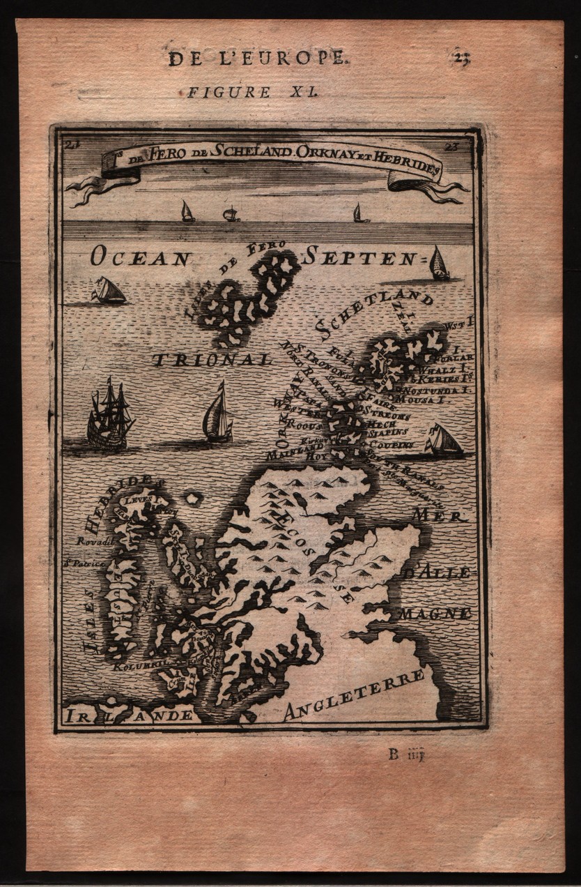
Map title
De Fero de Scheland Orknay et Hebrides
Author
Mallet
Location shown in map
North of England
Edition date
1683
Edition place
Paris
Editor
--
Atlas
Description de l'univers - Chez Denis Thierry
Price
75 Euro
State
[mint/EXCELLENT/very good/good/fair/mediocre/poor] Only a small part of the map.
Color
Black/white
Verso
French text pag 24
Size
Plate: cm (10.2 x 15.2) inches (4.02 x 5.98) Paper: cm (12.7 x 20.3) inches (5 x 7.99)
Technique
Copper engraving
Note
No particular notes for this maps
Reference
--
Wiki
Here for more info
In stock
Available
Info
info@thetreasuremaps.com
Code
#0140
×
![De Fero de Scheland Orknay et Hebrides by Mallet, North of England, 1683]()
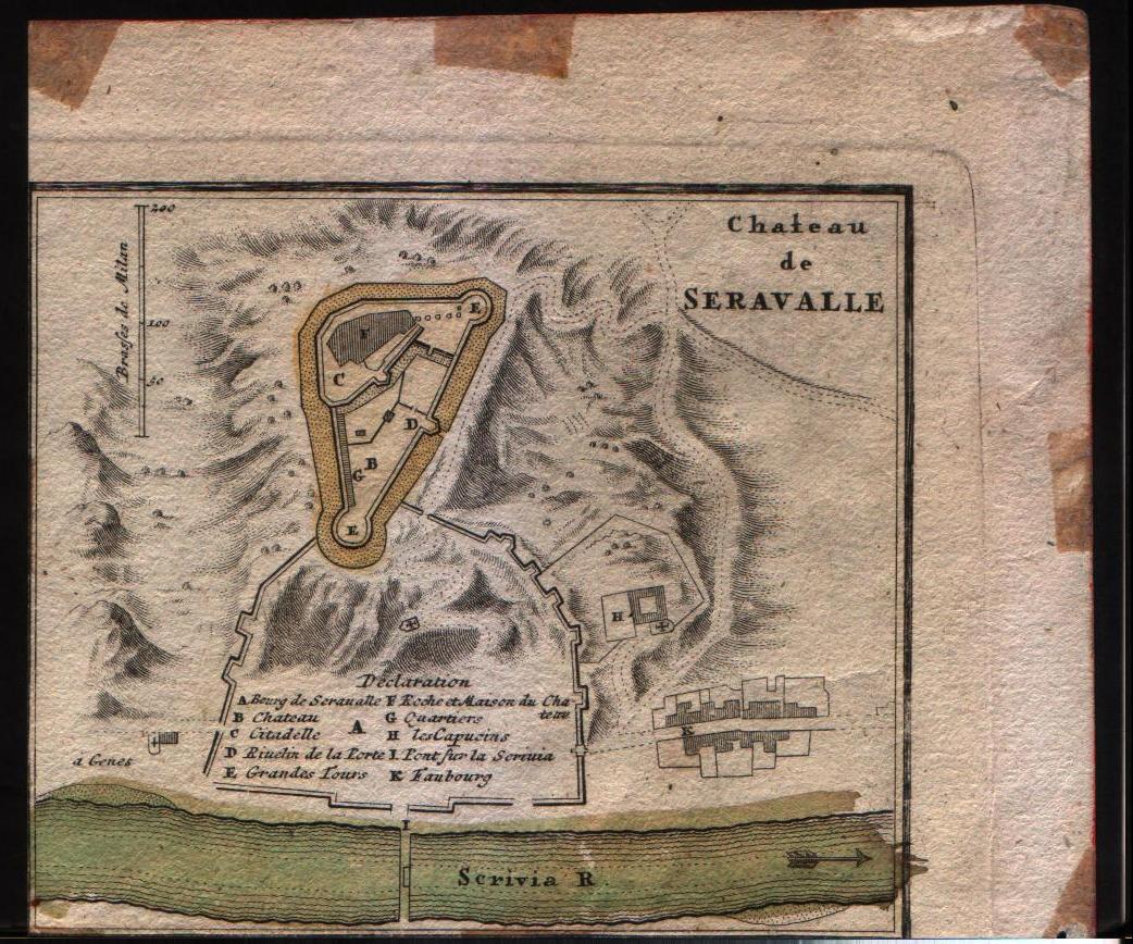
Map title
Pianta di Cremona e delle altre fortezze de Milano
Author
Homann
Location shown in map
Chateau de Seravalle
Edition date
Unknown
Edition place
--
Editor
--
Atlas
--
Price
Please ask: info@thetreasuremaps.com
State
[mint/excellent/very good/good/fair/mediocre/POOR] Only a small part of the map.
Color
Old outlined
Verso
Blank
Size
Plate: cm (14 x 12.7) inches (5.51 x 5) Paper: cm (16.5 x 15.2) inches (6.5 x 5.98)
Technique
Copper engraving
Note
No particular notes for this maps
Reference
--
Wiki
Here for more info
In stock
Available
Info
info@thetreasuremaps.com
Code
#0141
×
![Pianta di Cremona e delle altre fortezze de Milano by Homann, Chateau de Seravalle, Unknown]()

Map title
Utriusque Burgundiae, tum Ducatus tum Comitatus
Author
Merian
Location shown in map
Burgundia, France
Edition date
1695
Edition place
Frankfurt
Editor
--
Atlas
--
Price
Please ask: info@thetreasuremaps.com
State
[mint/excellent/very good/GOOD/fair/mediocre/poor]
Color
Black/white
Verso
Blank
Size
Plate: cm (35.6 x 26.7) inches (14.02 x 10.51) Paper: cm (36.8 x 33) inches (14.49 x 12.99)
Technique
Copper engraving
Note
--
Reference
--
Wiki
Here for more info
In stock
Available
Info
info@thetreasuremaps.com
Code
#0143
×
![Utriusque Burgundiae, tum Ducatus tum Comitatus by Merian, Burgundia, France, 1695]()
Map title
Lotharingia Ducatus Vulgo Lorraine
Author
Merian
Location shown in map
Loraine, France
Edition date
1695
Edition place
Frankfurt
Editor
--
Atlas
--
Price
Please ask: info@thetreasuremaps.com
State
[mint/excellent/very good/GOOD/fair/mediocre/poor]
Color
Black/white
Verso
Blank
Size
Plate: cm (35.6 x 26.7) inches (14.02 x 10.51) Paper: cm (36.8 x 33) inches (14.49 x 12.99)
Technique
Copper engraving
Note
--
Reference
--
Wiki
Here for more info
In stock
Available
Info
info@thetreasuremaps.com
Code
#0144
×
![Lotharingia Ducatus Vulgo Lorraine by Merian, Loraine, France, 1695]()
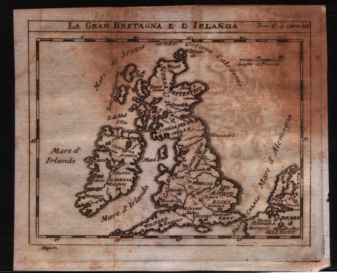
Map title
La Gran Bretagna e l'Irlanda
Author
Unknown
Location shown in map
British Isles
Edition date
1730
Edition place
???
Editor
--
Atlas
--
Price
125 Euro
State
[mint/excellent/VERY GOOD/good/fair/mediocre/poor]
Color
Black/white
Verso
Blank
Size
Plate: cm (15.2 x 12.7) inches (5.98 x 5) Paper: cm (18.4 x 15.9) inches (7.24 x 6.26)
Technique
Copper engraving
Note
No particular notes for this maps
Reference
--
Wiki
Here for more info
In stock
Available
Info
info@thetreasuremaps.com
Code
#0145
×
![La Gran Bretagna e l'Irlanda by Unknown, British Isles, 1730]()
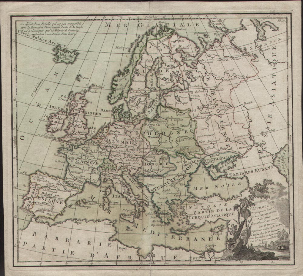
Map title
L'Europe
Author
Louise Brion De La Tour
Location shown in map
Europe
Edition date
1786
Edition place
Paris
Editor
--
Atlas
La geographie
Price
75 Euro
State
[mint/EXCELLENT/very good/good/fair/mediocre/poor]
Color
Black/white
Verso
Blank
Size
Plate: cm (25.4 x 22.9) inches (10 x 9.02) Paper: cm (27.9 x 25.4) inches (10.98 x 10)
Technique
Copper engraving
Note
No particular notes for this maps
Reference
--
Wiki
Here for more info
In stock
Available
Info
info@thetreasuremaps.com
Code
#0146
×
![L'Europe by Louise Brion De La Tour, Europe, 1786]()
Map title
Carte de l'Ancienne Germanie pour servir a l'intelligence de l'Historie Universelle
Author
Unknown
Location shown in map
Germany during roman age
Edition date
Unknown
Edition place
???
Editor
--
Atlas
--
Price
Please ask: info@thetreasuremaps.com
State
[mint/EXCELLENT/very good/good/fair/mediocre/poor]
Color
Black/white
Verso
Blank
Size
Plate: cm (30.5 x 20.3) inches (12.01 x 7.99) Paper: cm (36.8 x 25.4) inches (14.49 x 10)
Technique
Copper engraving
Note
No particular notes for this maps
Reference
--
Wiki
Here for more info
In stock
Available
Info
info@thetreasuremaps.com
Code
#0147
×
![Carte de l'Ancienne Germanie pour servir a l'intelligence de l'Historie Universelle by Unknown, Germany during roman age, Unknown]()
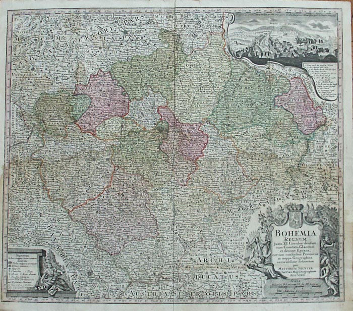
Map title
Bohemia regnum
Author
Seutter, Matthaus
Location shown in map
Bohemia
Edition date
1730
Edition place
Augsburg
Editor
--
Atlas
--
Price
250 Euro
State
[mint/excellent/very good/GOOD/fair/mediocre/poor]
Color
Old color
Verso
Blank
Size
Plate: cm (55.9 x 49.5) inches (22.01 x 19.49) Paper: cm (58.4 x 52.1) inches (22.99 x 20.51)
Technique
Copper engraving
Note
No particular notes for this maps
Reference
--
Wiki
Here for more info
In stock
Available
Info
info@thetreasuremaps.com
Code
#0148
×
![Bohemia regnum by Seutter, Matthaus, Bohemia, 1730]()
Map title
Vindelicie, Rhetie et Noricie
Author
Unknown
Location shown in map
Austria
Edition date
Unknown
Edition place
???
Editor
--
Atlas
--
Price
Please ask: info@thetreasuremaps.com
State
[mint/EXCELLENT/very good/good/fair/mediocre/poor]
Color
Black/white
Verso
Blank
Size
Plate: cm (38.1 x 25.4) inches (15 x 10) Paper: cm (27.9 x 17.8) inches (10.98 x 7.01)
Technique
Copper engraving
Note
No particular notes for this maps
Reference
--
Wiki
Here for more info
In stock
Available
Info
info@thetreasuremaps.com
Code
#0149
×
![Vindelicie, Rhetie et Noricie by Unknown, Austria, Unknown]()
Map title
Italie
Author
Sanson
Location shown in map
Italy
Edition date
1743
Edition place
Amsterdam
Editor
--
Atlas
Introduction A L'Historie General Et Politique De L'Univeri
Price
Please ask: info@thetreasuremaps.com
State
[mint/EXCELLENT/very good/good/fair/mediocre/poor]
Color
Black/white
Verso
Blank
Size
Plate: cm (16.5 x 14) inches (6.5 x 5.51) Paper: cm (16.5 x 14) inches (6.5 x 5.51)
Technique
Copper engraving
Note
Reference
--
Wiki
Here for more info
In stock
Available
Info
info@thetreasuremaps.com
Code
#0151
×
![Italie by Sanson, Italy, 1743]()
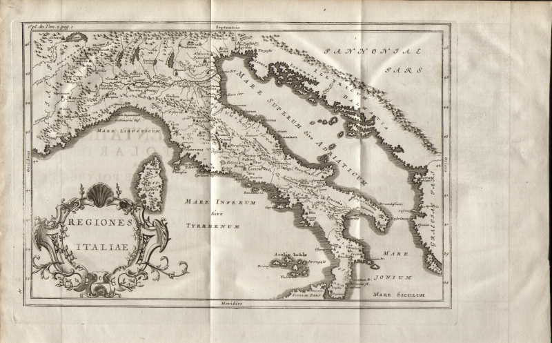
Map title
Regiones Italiae
Author
Unknown
Location shown in map
Italy
Edition date
1754
Edition place
Paris
Editor
--
Atlas
Abrege de l'Histoire de Polybe
Price
50 Euro
State
[MINT/excellent/very good/good/fair/mediocre/poor]
Color
Black/white
Verso
Blank
Size
Plate: cm (30.5 x 20.3) inches (12.01 x 7.99) Paper: cm (39.4 x 25.4) inches (15.51 x 10)
Technique
Copper engraving
Note
Reference
--
Wiki
Here for more info
In stock
Available
Info
info@thetreasuremaps.com
Code
#0152
×
![Regiones Italiae by Unknown, Italy, 1754]()
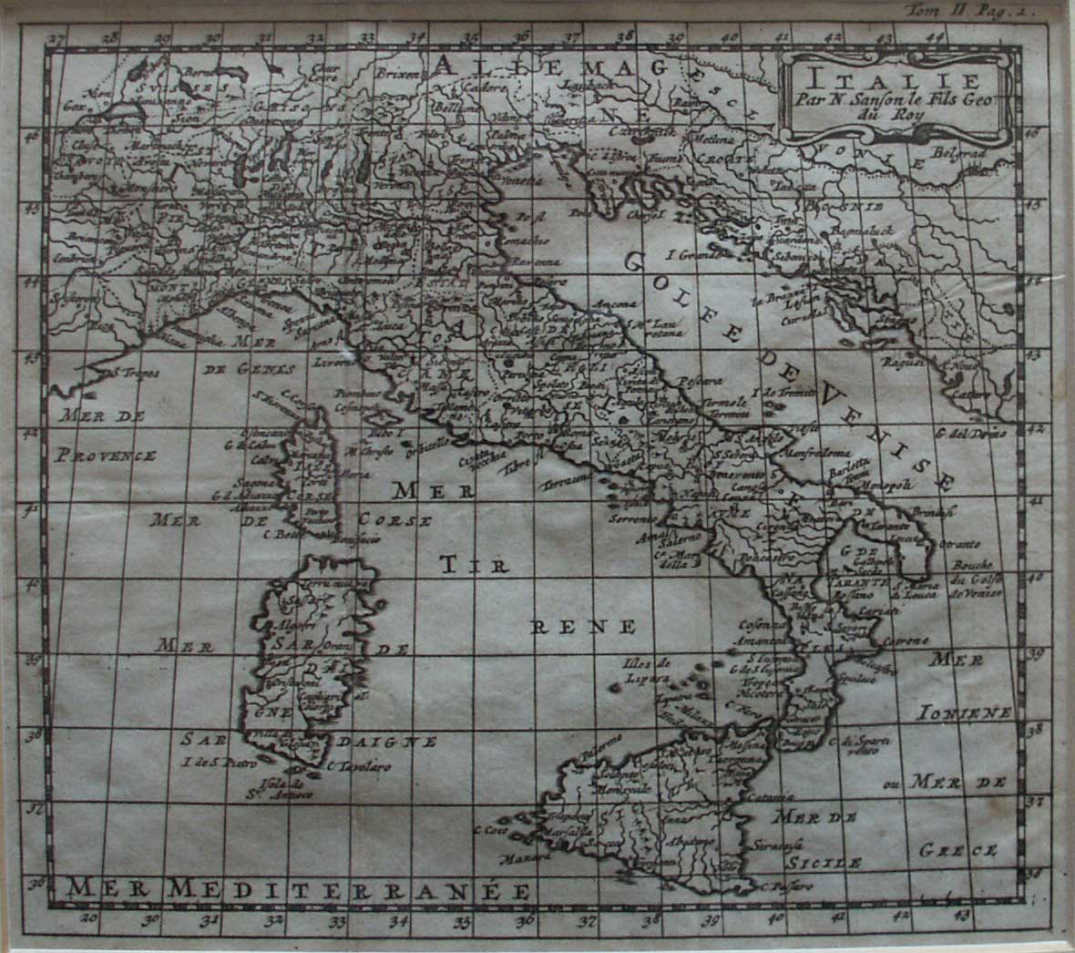
Map title
Italie
Author
Sanson
Location shown in map
Italy
Edition date
1743
Edition place
Amsterdam
Editor
--
Atlas
Introduction A L'Historie General Et Politique De L'Univeri
Price
Please ask: info@thetreasuremaps.com
State
[mint/EXCELLENT/very good/good/fair/mediocre/poor]
Color
Black/white
Verso
Blank
Size
Plate: cm (16.5 x 14) inches (6.5 x 5.51) Paper: cm (16.5 x 14) inches (6.5 x 5.51)
Technique
Copper engraving
Note
Reference
--
Wiki
Here for more info
In stock
Available
Info
info@thetreasuremaps.com
Code
#0154
×
![Italie by Sanson, Italy, 1743]()