News
Map title
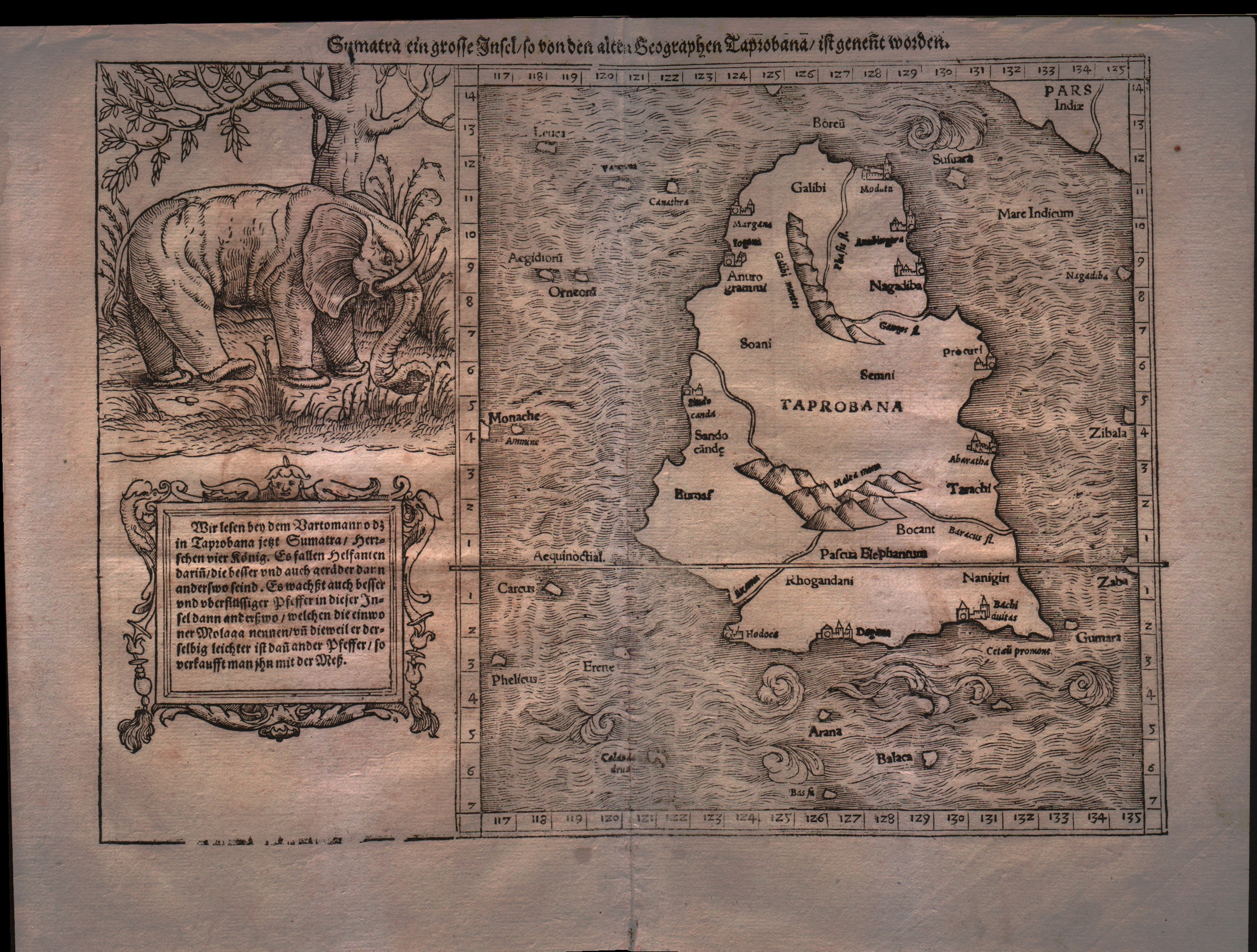
Sumatra ein grosse Inseln so von den alten Geographen Taprobana ist genent worden
Author
Munster
Location shown in map
Ceylon
Edition date
1555
Edition place
Basel
Editor
Henrich Petri
Atlas
Cosmographia Universalis
Price
500 Euro
State
[mint/EXCELLENT/very good/good/fair/mediocre/poor]
Color
Black/white
Verso
German text
Size
Plate: cm (33 x 24.1) inches (12.99 x 9.49) Paper: cm (30.5 x 40.6) inches (12.01 x 15.98)
Technique
Woodcut
Note
With large elephant vignette. Tabulae Asiae XII.
Reference
--
Wiki
Here for more info
In stock
Available
Info
info@thetreasuremaps.com
Code
#0177
×
![Sumatra ein grosse Inseln so von den alten Geographen Taprobana ist genent worden by Munster, Ceylon, 1555]()
Map title
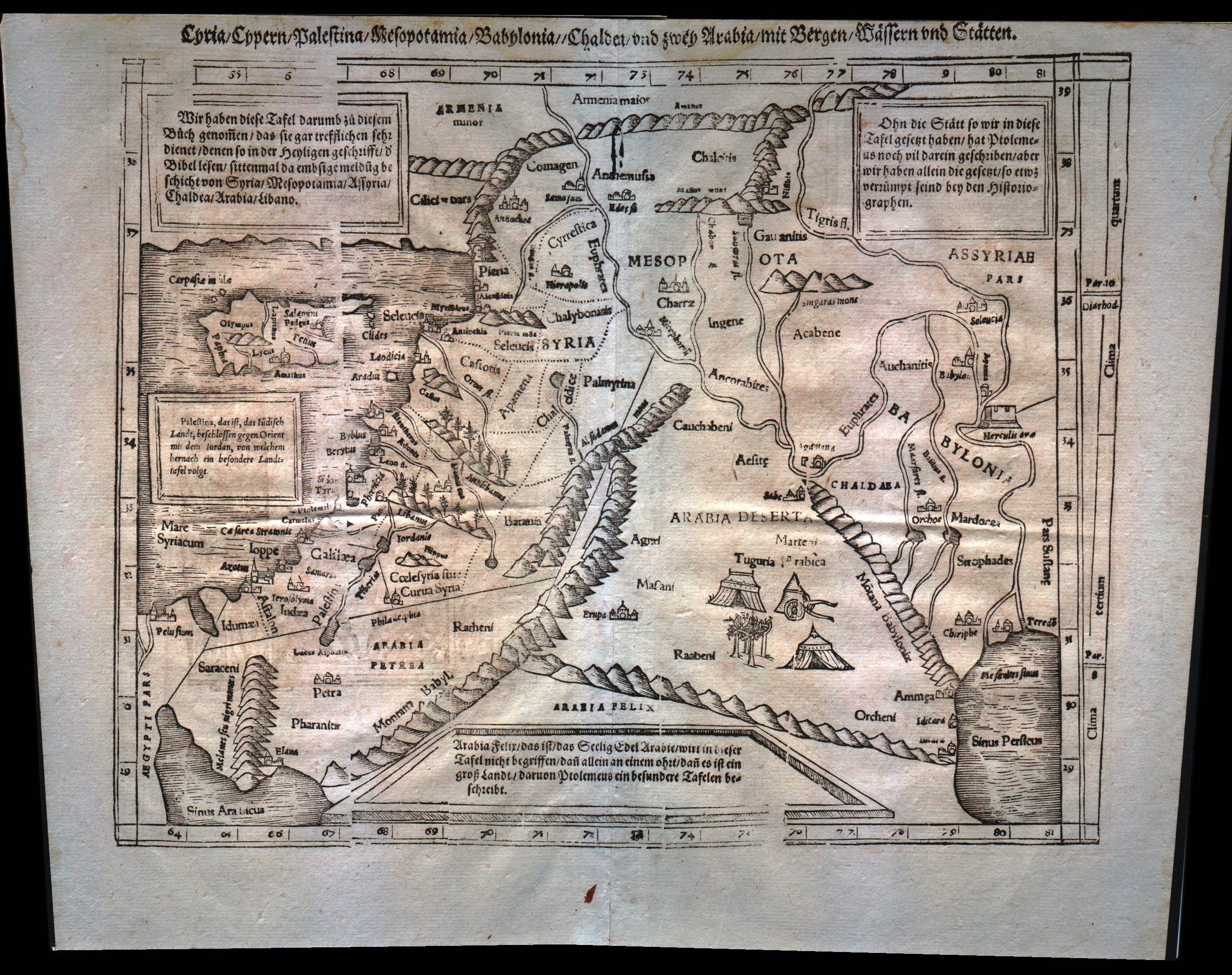
Syria Cypern Palestina Mesopotamia Babylonia Chaldea und zwey Arabia mit Bergen Wassern und Statten
Author
Munster
Location shown in map
Holy Land
Edition date
1555
Edition place
Basel
Editor
Henrich Petri
Atlas
Cosmographia Universalis
Price
300 Euro
State
[mint/excellent/very good/GOOD/fair/mediocre/poor]
Color
Black/white
Verso
German text
Size
Plate: cm (34.3 x 25.4) inches (13.5 x 10) Paper: cm (40.6 x 31.8) inches (15.98 x 12.52)
Technique
Woodcut
Note
Middle East from the Nile Delta to the southern coast of Turkey. Tabulae Asiae IV.
Reference
--
Wiki
Here for more info
In stock
Available
Info
info@thetreasuremaps.com
Code
#0178
×
![Syria Cypern Palestina Mesopotamia Babylonia Chaldea und zwey Arabia mit Bergen Wassern und Statten by Munster, Holy Land, 1555]()
Map title
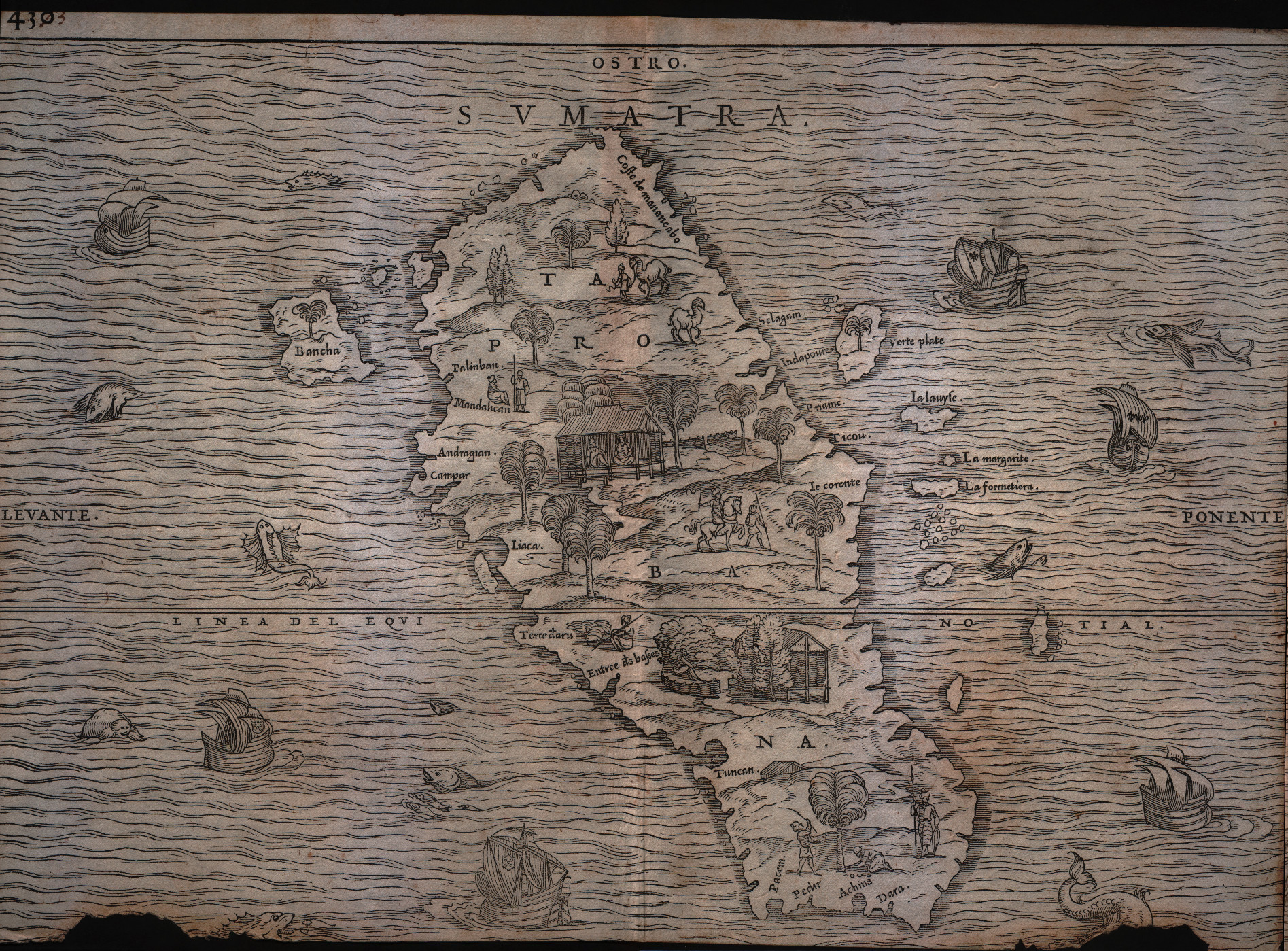
Sumatra
Author
Gastaldi
Location shown in map
Sumatra
Edition date
1613
Edition place
Venice
Editor
Giambattista Ramusio
Atlas
Delle navigazioni e viaggi
Price
Please ask: info@thetreasuremaps.com
State
[mint/excellent/very good/good/FAIR/mediocre/poor]
Color
Black/white
Verso
pag.430
Size
Plate: cm (36.8 x 26.7) inches (14.49 x 10.51) Paper: cm (36.8 x 26.7) inches (14.49 x 10.51)
Technique
Woodcut
Note
Decorated with sea monsters and sailing ships.
Reference
--
Wiki
Here for more info
In stock
Available
Info
info@thetreasuremaps.com
Code
#0179
Sumatra
Author
Gastaldi
Location shown in map
Sumatra
Edition date
1613
Edition place
Venice
Editor
Giambattista Ramusio
Atlas
Delle navigazioni e viaggi
Price
Please ask: info@thetreasuremaps.com
State
[mint/excellent/very good/good/FAIR/mediocre/poor]
Color
Black/white
Verso
pag.430
Size
Plate: cm (36.8 x 26.7) inches (14.49 x 10.51) Paper: cm (36.8 x 26.7) inches (14.49 x 10.51)
Technique
Woodcut
Note
Decorated with sea monsters and sailing ships.
Reference
--
Wiki
Here for more info
In stock
Available
Info
info@thetreasuremaps.com
Code
#0179
×
![Sumatra by Gastaldi, Sumatra, 1613]()
Map title
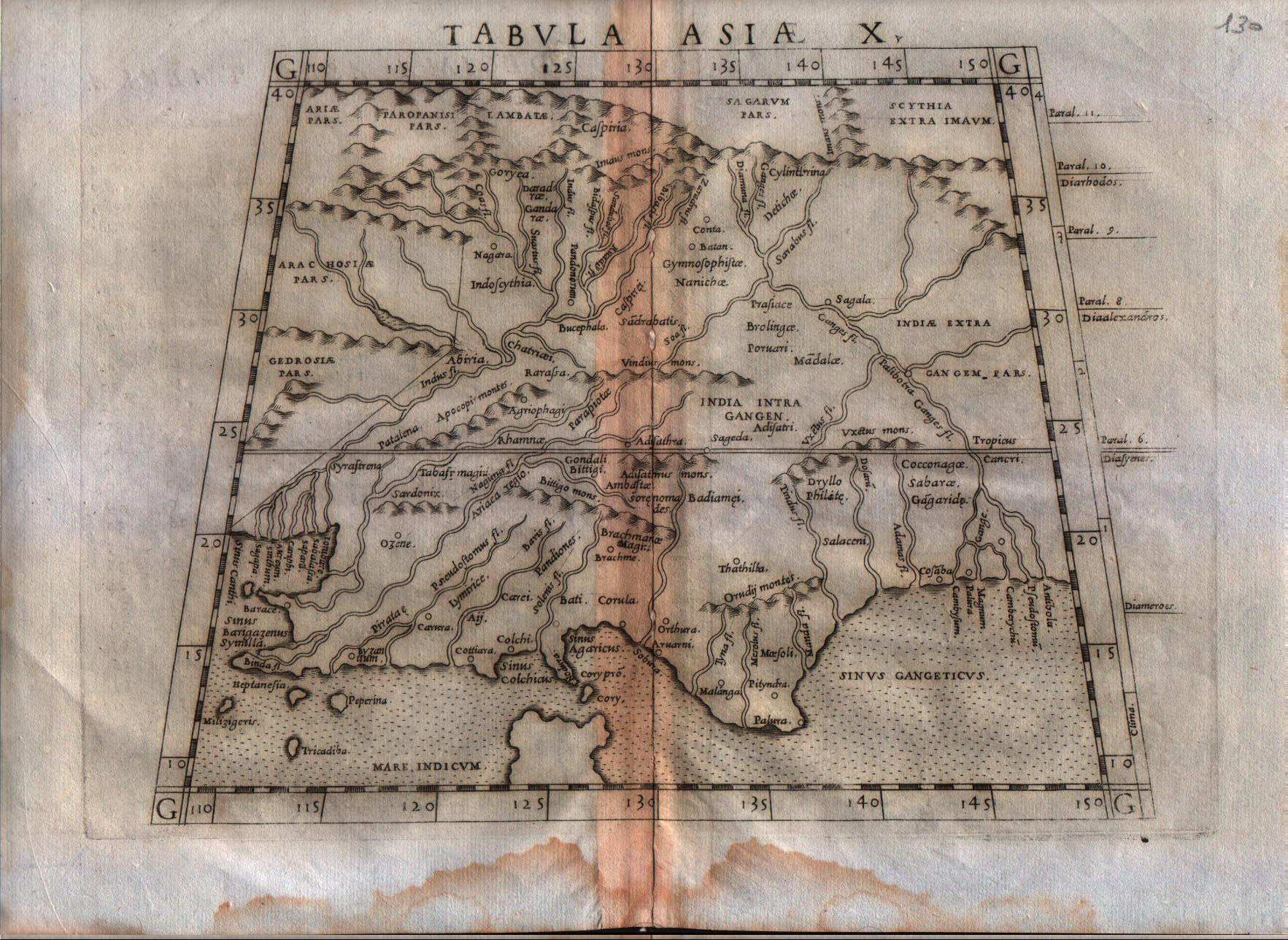
Tabula Asiae X
Author
Ruscelli
Location shown in map
India
Edition date
1564
Edition place
Venice
Editor
Girolamo Ziletti
Atlas
La Geographia di Claudio Tolomeo
Price
200 Euro
State
[mint/excellent/VERY GOOD/good/fair/mediocre/poor]
Color
Black/white
Verso
Latin text pag.54
Size
Plate: cm (25.4 x 19) inches (10 x 7.48) Paper: cm (30.5 x 22.9) inches (12.01 x 9.02)
Technique
Copper engraving
Note
India shown.
Reference
--
Wiki
Here for more info
In stock
Available
Info
info@thetreasuremaps.com
Code
#0181
×
![Tabula Asiae X by Ruscelli, India, 1564]()
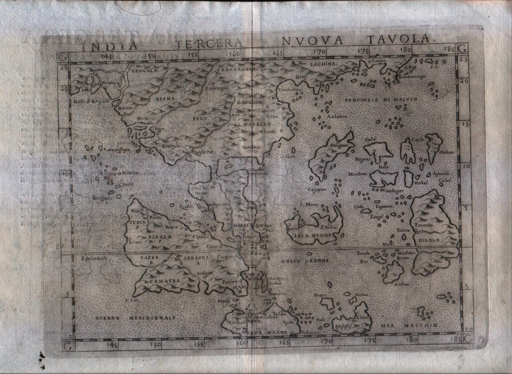
Map title
India tercera nova tabula
Author
Ruscelli
Location shown in map
Southeast Asia
Edition date
1574
Edition place
Venice
Editor
Giordano Ziletti
Atlas
La Geographia di Claudio Tolomeo
Price
500 Euro
State
[mint/excellent/VERY GOOD/good/fair/mediocre/poor]
Color
Black/white
Verso
Italian text pag.30
Size
Plate: cm (25.4 x 19) inches (10 x 7.48) Paper: cm (30.5 x 22.9) inches (12.01 x 9.02)
Technique
Copper engraving
Note
India shown.
Reference
Genoa pubblic library "Civica Berio"
Wiki
Here for more info
In stock
Available
Info
info@thetreasuremaps.com
Code
#0182
×
![India tercera nova tabula by Ruscelli, Southeast Asia, 1574]()
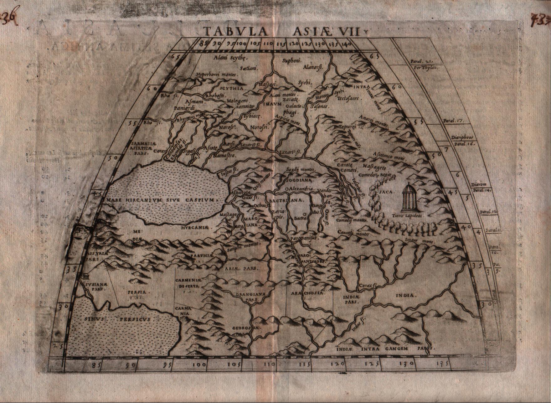
Map title
Tabula Asiae VII
Author
Ruscelli
Location shown in map
Iran
Edition date
1574
Edition place
Venice
Editor
Giordano Ziletti
Atlas
La Geographia di Claudio Tolomeo
Price
125 Euro
State
[mint/EXCELLENT/very good/good/fair/mediocre/poor]
Color
Black/white
Verso
Italian text pag.22
Size
Plate: cm (25.4 x 19) inches (10 x 7.48) Paper: cm (30.5 x 22.9) inches (12.01 x 9.02)
Technique
Copper engraving
Note
--
Reference
Genoa pubblic library "Civica Berio"
Wiki
Here for more info
In stock
Available
Info
info@thetreasuremaps.com
Code
#0183
×
![Tabula Asiae VII by Ruscelli, Iran, 1574]()
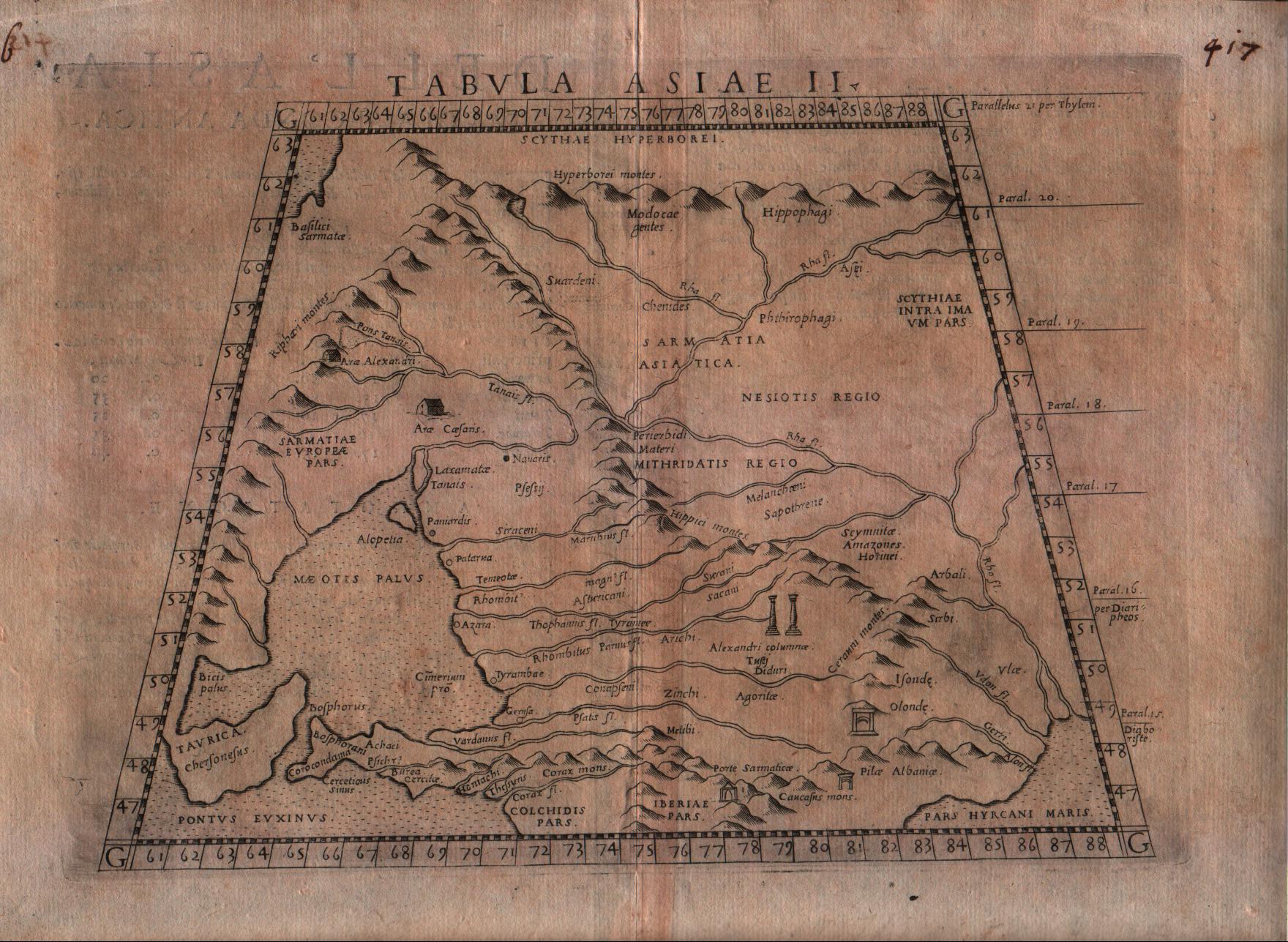
Map title
Tabula Asiae II
Author
Ruscelli
Location shown in map
South Russia
Edition date
1574
Edition place
Venice
Editor
Giordano Ziletti
Atlas
La Geographia di Claudio Tolomeo
Price
125 Euro
State
[mint/EXCELLENT/very good/good/fair/mediocre/poor]
Color
Black/white
Verso
Italian text pag.17
Size
Plate: cm (25.4 x 19) inches (10 x 7.48) Paper: cm (30.5 x 22.9) inches (12.01 x 9.02)
Technique
Copper engraving
Note
--
Reference
Genoa pubblic library "Civica Berio"
Wiki
Here for more info
In stock
Available
Info
info@thetreasuremaps.com
Code
#0185
×
![Tabula Asiae II by Ruscelli, South Russia, 1574]()
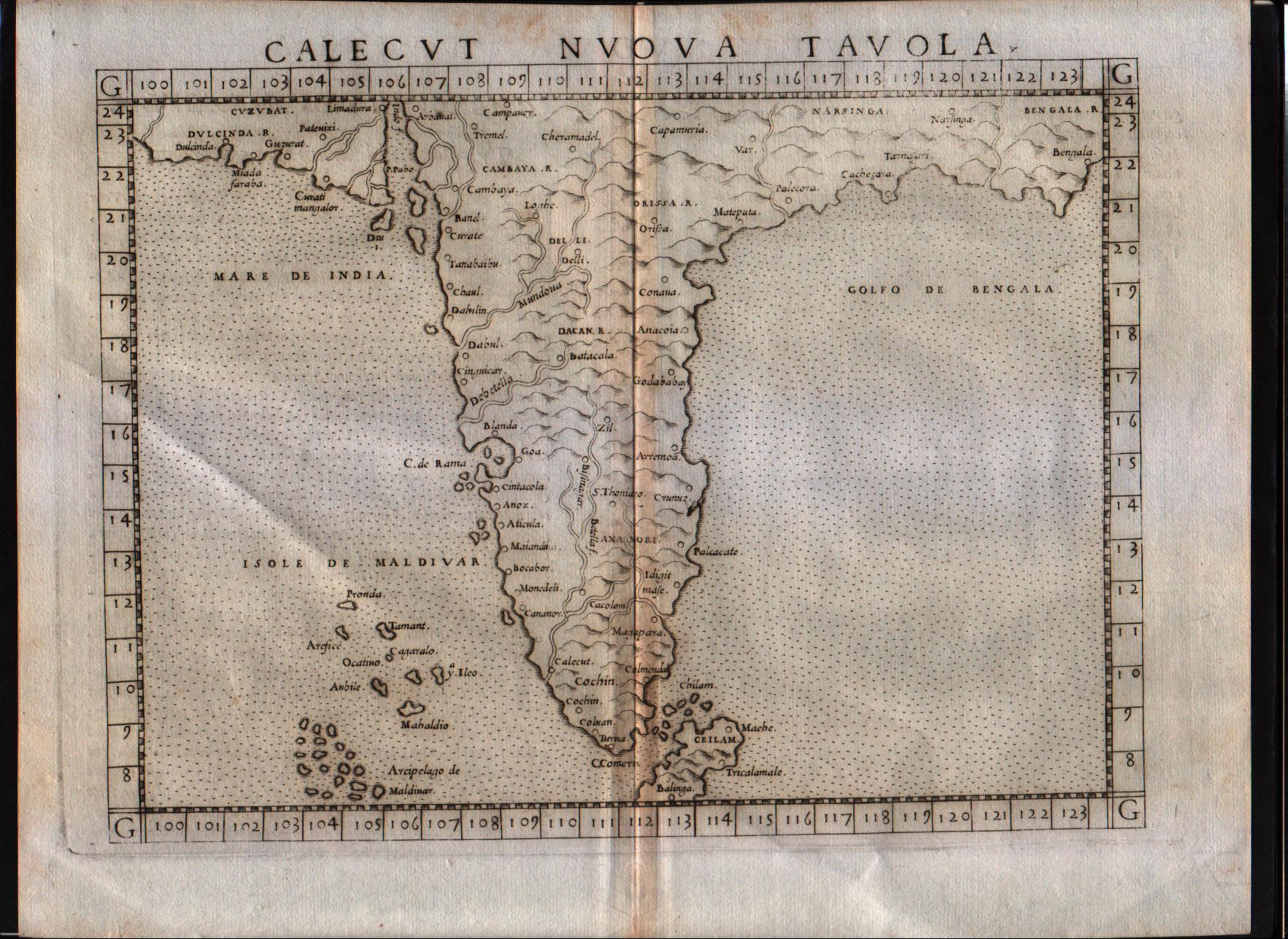
Map title
Calecut Nuova Tavola
Author
Ruscelli
Location shown in map
India
Edition date
1564
Edition place
Venice
Editor
Girolamo Ziletti
Atlas
La Geographia di Claudio Tolomeo
Price
500 Euro
State
[MINT/excellent/very good/good/fair/mediocre/poor]
Color
Black/white
Verso
Latin text pag.55
Size
Plate: cm (25.4 x 19) inches (10 x 7.48) Paper: cm (30.5 x 22.9) inches (12.01 x 9.02)
Technique
Copper engraving
Note
India shown.
Reference
--
Wiki
Here for more info
In stock
Available
Info
info@thetreasuremaps.com
Code
#0186
×
![Calecut Nuova Tavola by Ruscelli, India, 1564]()
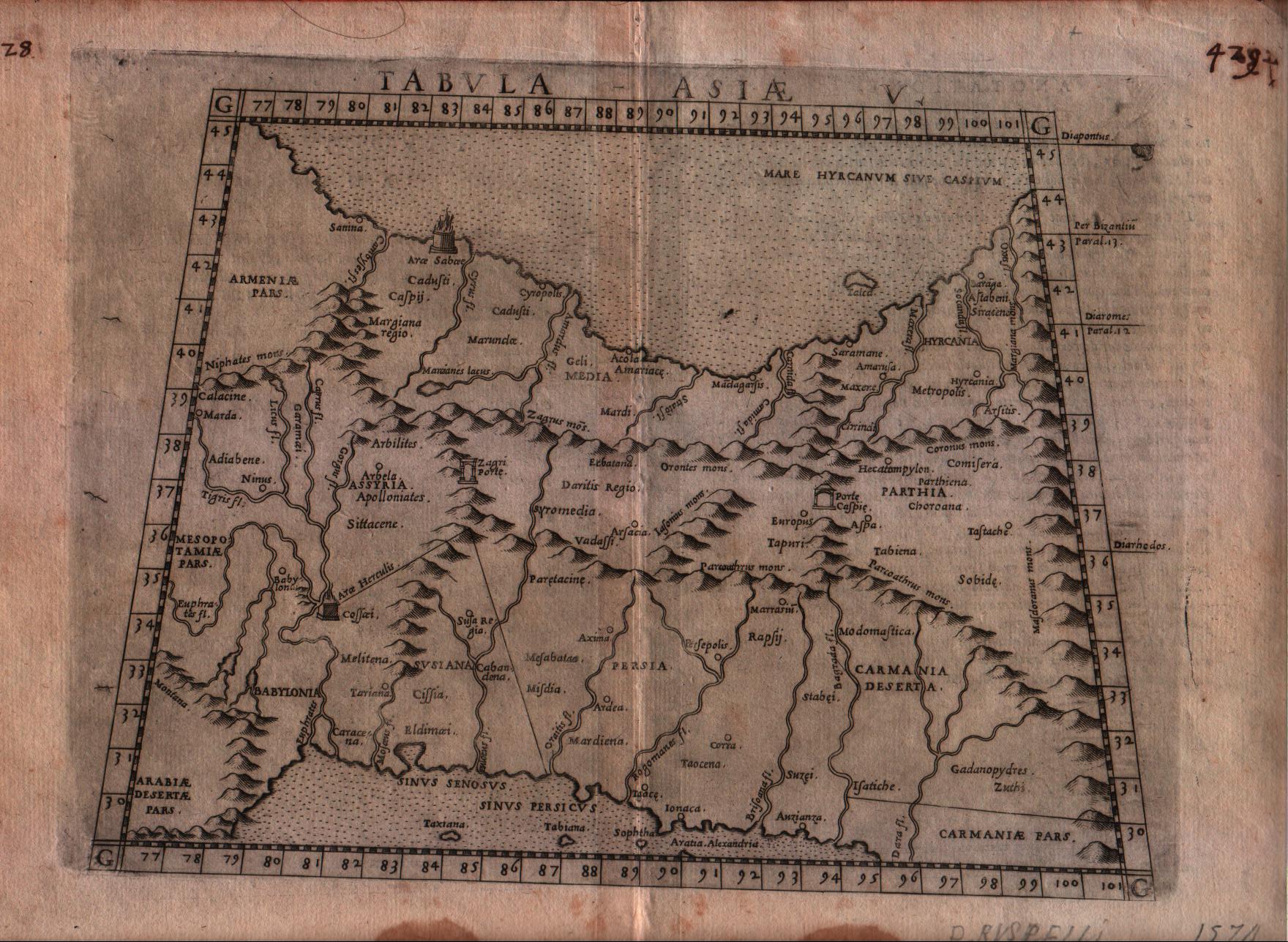
Map title
Tabula Asiae V
Author
Ruscelli
Location shown in map
Persia and west Pakistan
Edition date
1574
Edition place
Venice
Editor
Giordano Ziletti
Atlas
La Geographia di Claudio Tolomeo
Price
150 Euro
State
[mint/excellent/VERY GOOD/good/fair/mediocre/poor]
Color
Black/white
Verso
Italian text pag.20
Size
Plate: cm (25.4 x 19) inches (10 x 7.48) Paper: cm (30.5 x 22.9) inches (12.01 x 9.02)
Technique
Copper engraving
Note
Persia and west Pakistan shown.
Reference
Genoa pubblic library "Civica Berio"
Wiki
Here for more info
In stock
Available
Info
info@thetreasuremaps.com
Code
#0187
×
![Tabula Asiae V by Ruscelli, Persia and west Pakistan, 1574]()
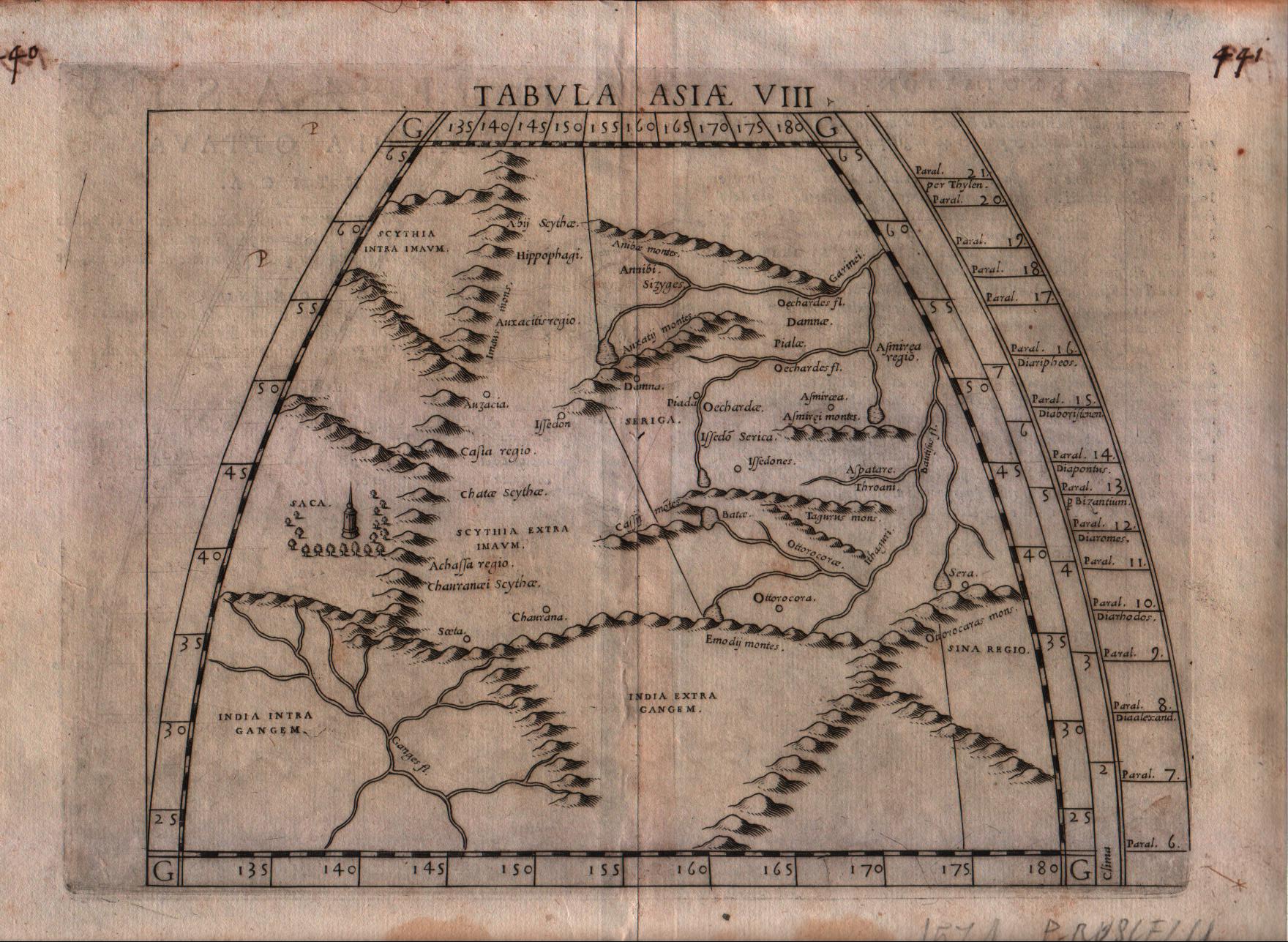
Map title
Tabula Asiae VIII
Author
Ruscelli
Location shown in map
Central Asia
Edition date
1574
Edition place
Venice
Editor
Giordano Ziletti
Atlas
La Geographia di Claudio Tolomeo
Price
125 Euro
State
[mint/EXCELLENT/very good/good/fair/mediocre/poor]
Color
Black/white
Verso
Italian text pag.23
Size
Plate: cm (25.4 x 19) inches (10 x 7.48) Paper: cm (30.5 x 22.9) inches (12.01 x 9.02)
Technique
Copper engraving
Note
--
Reference
Genoa pubblic library "Civica Berio"
Wiki
Here for more info
In stock
Available
Info
info@thetreasuremaps.com
Code
#0188
×
![Tabula Asiae VIII by Ruscelli, Central Asia, 1574]()
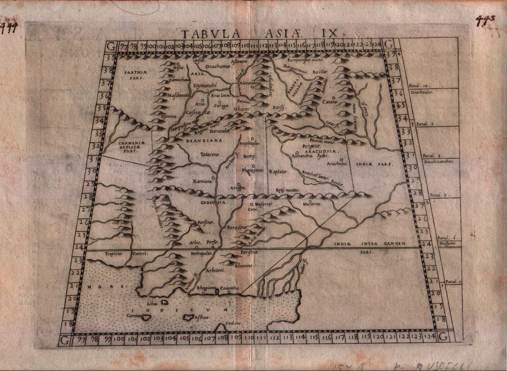
Map title
Tabula Asiae IX
Author
Ruscelli
Location shown in map
Pakistan
Edition date
1574
Edition place
Venice
Editor
Giordano Ziletti
Atlas
La Geographia di Claudio Tolomeo
Price
125 Euro
State
[mint/EXCELLENT/very good/good/fair/mediocre/poor]
Color
Black/white
Verso
Italian text pag.24
Size
Plate: cm (25.4 x 19) inches (10 x 7.48) Paper: cm (30.5 x 22.9) inches (12.01 x 9.02)
Technique
Copper engraving
Note
Pakistan shown.
Reference
Genoa pubblic library "Civica Berio"
Wiki
Here for more info
In stock
Available
Info
info@thetreasuremaps.com
Code
#0189
×
![Tabula Asiae IX by Ruscelli, Pakistan, 1574]()
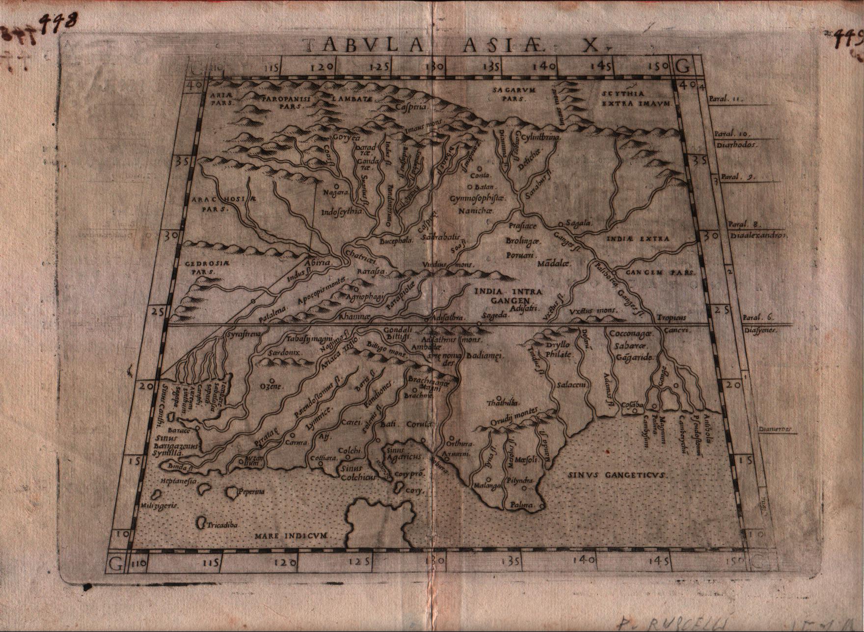
Map title
Tabula Asiae X
Author
Ruscelli
Location shown in map
India
Edition date
1574
Edition place
Venice
Editor
Giordano Ziletti
Atlas
La Geographia di Claudio Tolomeo
Price
200 Euro
State
[mint/EXCELLENT/very good/good/fair/mediocre/poor]
Color
Black/white
Verso
Italian text pag.25
Size
Plate: cm (25.4 x 19) inches (10 x 7.48) Paper: cm (30.5 x 22.9) inches (12.01 x 9.02)
Technique
Copper engraving
Note
India shown.
Reference
Genoa pubblic library "Civica Berio"
Wiki
Here for more info
In stock
Available
Info
info@thetreasuremaps.com
Code
#0190
×
![Tabula Asiae X by Ruscelli, India, 1574]()
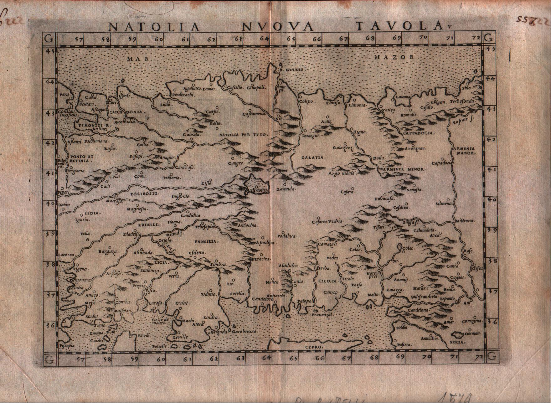
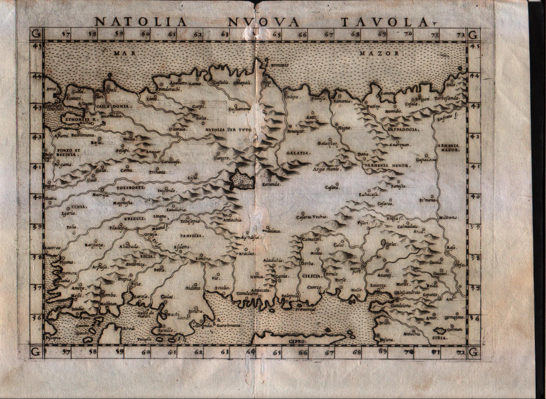
Map title
Natolia nuova tavola
Author
Ruscelli
Location shown in map
Turkey
Edition date
1574
Edition place
Venice
Editor
Giordano Ziletti
Atlas
La Geographia di Claudio Tolomeo
Price
150 Euro
State
[mint/EXCELLENT/very good/good/fair/mediocre/poor]
Color
Black/white
Verso
Italian text pag.24
Size
Plate: cm (25.4 x 19) inches (10 x 7.48) Paper: cm (30.5 x 22.9) inches (12.01 x 9.02)
Technique
Copper engraving
Note
--
Reference
Genoa pubblic library "Civica Berio"
Wiki
Here for more info
In stock
Available
Info
info@thetreasuremaps.com
Code
#0191
×
![Natolia nuova tavola by Ruscelli, Turkey, 1574]()
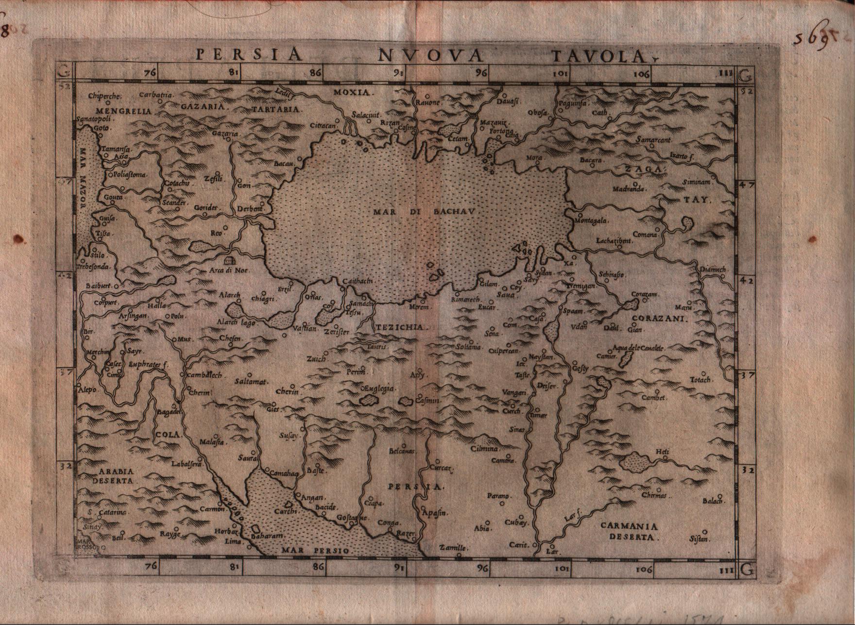
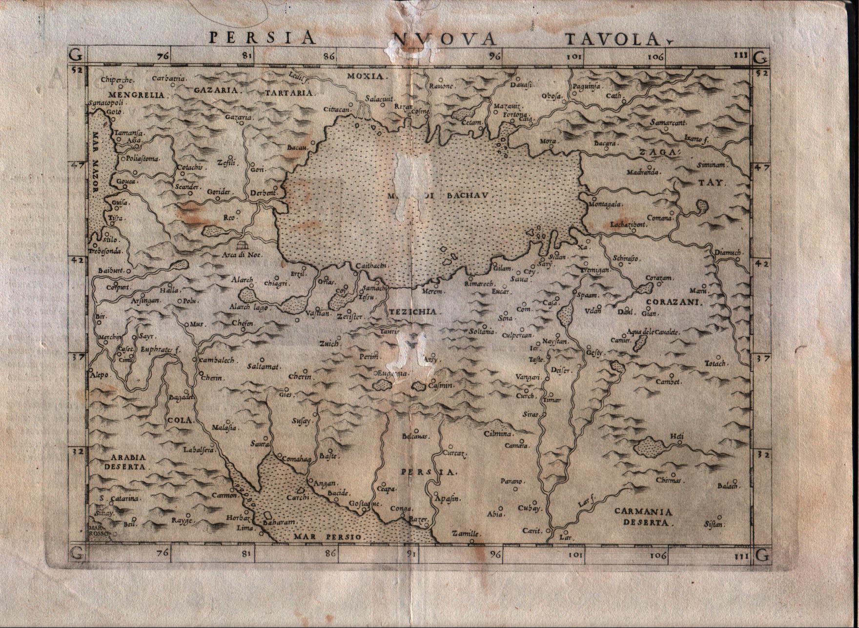
Map title
Persia nuova tavola
Author
Ruscelli
Location shown in map
Persia and west Pakistan
Edition date
1574
Edition place
Venice
Editor
Giordano Ziletti
Atlas
La Geographia di Claudio Tolomeo
Price
200 Euro
State
[mint/EXCELLENT/very good/good/fair/mediocre/poor]
Color
Black/white
Verso
Italian text pag.27
Size
Plate: cm (25.4 x 19) inches (10 x 7.48) Paper: cm (30.5 x 22.9) inches (12.01 x 9.02)
Technique
Copper engraving
Note
--
Reference
Genoa pubblic library "Civica Berio"
Wiki
Here for more info
In stock
Available
Info
info@thetreasuremaps.com
Code
#0192
×
![Persia nuova tavola by Ruscelli, Persia and west Pakistan, 1574]()
Map title
Natolia nuova tavola
Author
Ruscelli
Location shown in map
Turkey
Edition date
1561
Edition place
Venice
Editor
Vincenzo Valgrisi
Atlas
La Geographia di Claudio Tolomeo
Price
150 Euro
State
[mint/excellent/very good/GOOD/fair/mediocre/poor]
Color
Black/white
Verso
Italian text pag.23
Size
Plate: cm (25.4 x 19) inches (10 x 7.48) Paper: cm (30.5 x 22.9) inches (12.01 x 9.02)
Technique
Copper engraving
Note
Turkey shown.
Reference
Genoa pubblic library "Civica Berio"
Wiki
Here for more info
In stock
Available
Info
info@thetreasuremaps.com
Code
#0193
×
![Natolia nuova tavola by Ruscelli, Turkey, 1561]()
Map title
Persia nuova tavola
Author
Ruscelli
Location shown in map
Persia and west Pakistan
Edition date
1561
Edition place
Venice
Editor
Vincenzo Valgrisi
Atlas
La Geographia di Claudio Tolomeo
Price
200 Euro
State
[mint/excellent/very good/good/fair/MEDIOCRE/poor] repaired
Color
Black/white
Verso
Italian text pag.25
Size
Plate: cm (25.4 x 19) inches (10 x 7.48) Paper: cm (30.5 x 22.9) inches (12.01 x 9.02)
Technique
Copper engraving
Note
Persia and west Pakistan shown.
Reference
Genoa pubblic library "Civica Berio"
Wiki
Here for more info
In stock
Available
Info
info@thetreasuremaps.com
Code
#0194
×
![Persia nuova tavola by Ruscelli, Persia and west Pakistan, 1561]()

Map title
Tabula Asiae XII
Author
Ruscelli
Location shown in map
Ceylon
Edition date
1574
Edition place
Venice
Editor
Giordano Ziletti
Atlas
La Geographia di Claudio Tolomeo
Price
250 Euro
State
[mint/excellent/very good/good/FAIR/mediocre/poor]
Color
Black/white
Verso
Italian text pag.27
Size
Plate: cm (25.4 x 19) inches (10 x 7.48) Paper: cm (30.5 x 22.9) inches (12.01 x 9.02)
Technique
Copper engraving
Note
No particular notes for this maps
Reference
Genoa pubblic library "Civica Berio"
Wiki
Here for more info
In stock
Available
Info
info@thetreasuremaps.com
Code
#0195
×
![Tabula Asiae XII by Ruscelli, Ceylon, 1574]()
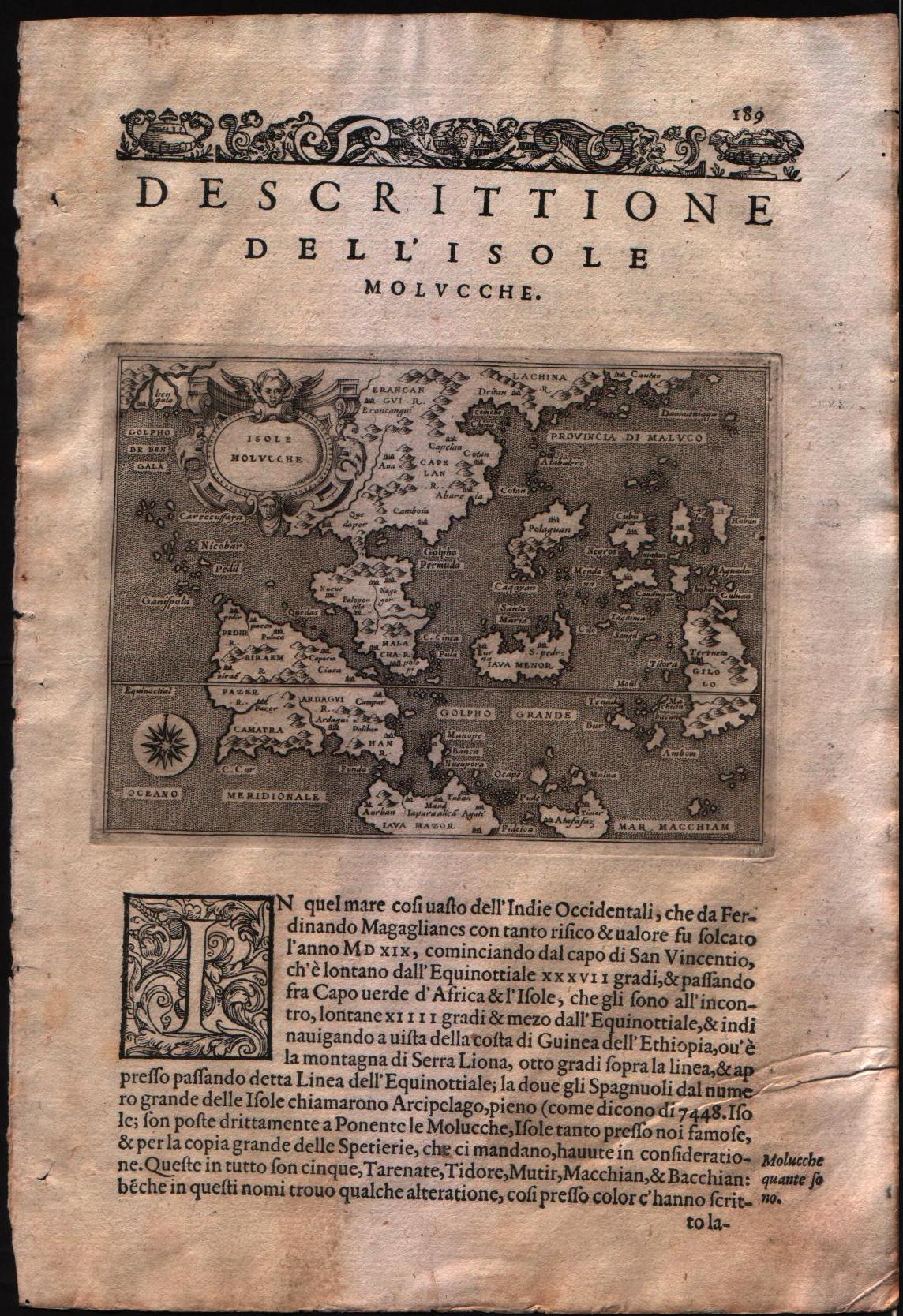
Map title
Descrittione dell'isole Molucche
Author
Porcacchi
Location shown in map
Southest Asia
Edition date
1576
Edition place
Venice
Editor
--
Atlas
L'Isole piu famose del mondo -- S. Galignani and G. Porro
Price
Please ask: info@thetreasuremaps.com
State
[MINT/excellent/very good/good/fair/mediocre/poor]
Color
Black/white
Verso
Italian text pag.190
Size
Plate: cm (15.2 x 11.4) inches (5.98 x 4.49) Paper: cm (19 x 27.9) inches (7.48 x 10.98)
Technique
Copper engraving
Note
No particular notes for this maps
Reference
Genoa pubblic library "Civica Berio"
Wiki
Here for more info
In stock
Available
Info
info@thetreasuremaps.com
Code
#0196
×
![Descrittione dell'isole Molucche by Porcacchi, Southest Asia, 1576]()
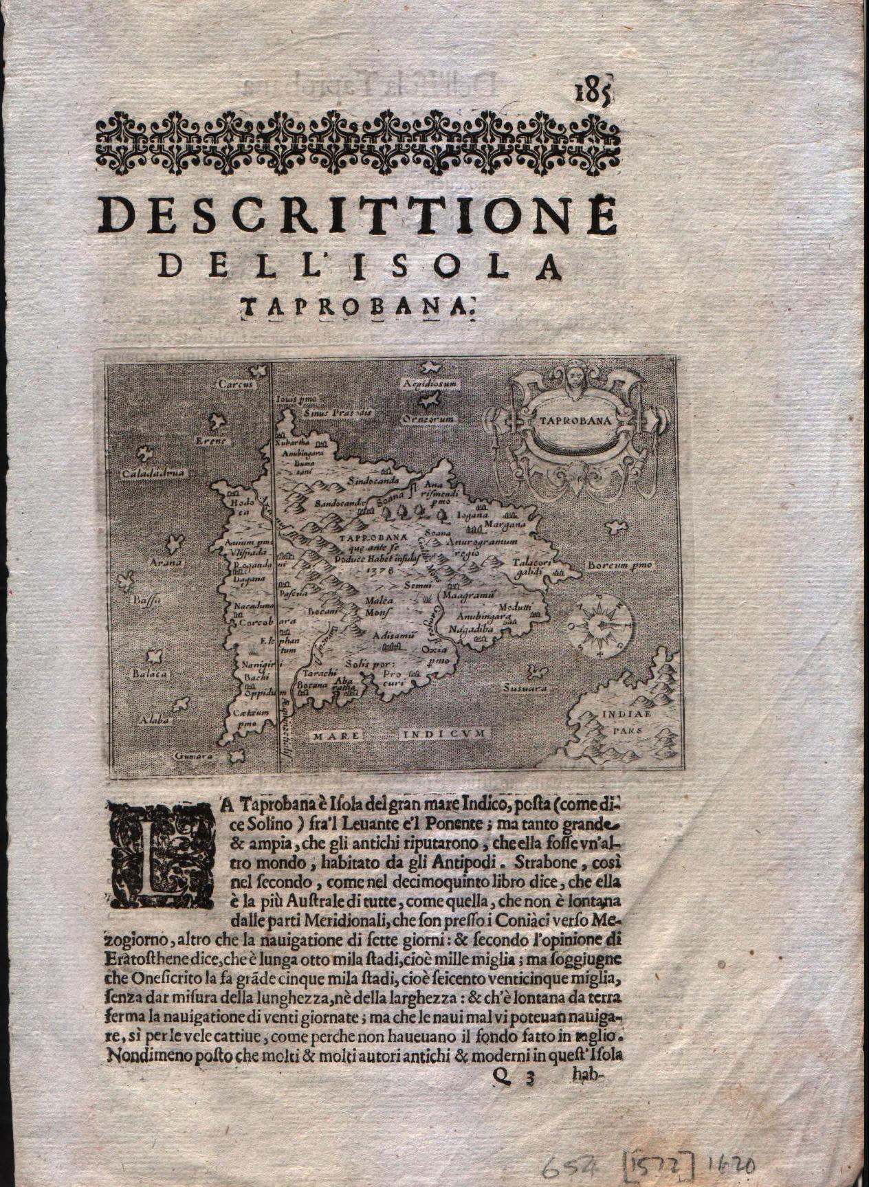
Map title
Descrittione dell'isole Taprobana
Author
Porcacchi
Location shown in map
Ceylon
Edition date
1620
Edition place
Venice
Editor
--
Atlas
L'Isole piu famose del mondo -- Pietr'Antonio Brigonci
Price
200 Euro
State
[MINT/excellent/very good/good/fair/mediocre/poor]
Color
Black/white
Verso
Italian text pag.186
Size
Plate: cm (14 x 11.4) inches (5.51 x 4.49) Paper: cm (20.3 x 30.5) inches (7.99 x 12.01)
Technique
Copper engraving
Note
No particular notes for this maps
Reference
--
Wiki
Here for more info
In stock
Available
Info
info@thetreasuremaps.com
Code
#0197
×
![Descrittione dell'isole Taprobana by Porcacchi, Ceylon, 1620]()
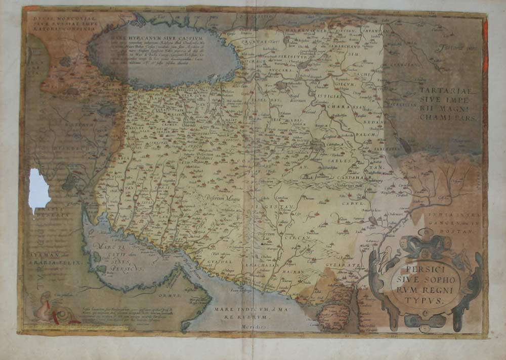
Map title
Persici Sive Sophorum Regni Typus
Author
Ortelius
Location shown in map
Persia
Edition date
1580
Edition place
--
Editor
--
Atlas
Theatrum Orbis Terrarum
Price
Please ask: info@thetreasuremaps.com
State
[mint/excellent/very good/good/fair/mediocre/POOR]
Color
Old colors
Verso
German text pag.85
Size
Plate: cm (49.5 x 36.8) inches (19.49 x 14.49) Paper: cm (53.3 x 40.6) inches (20.98 x 15.98)
Technique
Copper engraving
Note
No particular notes for this maps.
Reference
Van Den Broecke 167
Wiki
Here for more info
In stock
Available
Info
info@thetreasuremaps.com
Code
#0198
×
![Persici Sive Sophorum Regni Typus by Ortelius, Persia, 1580]()