News
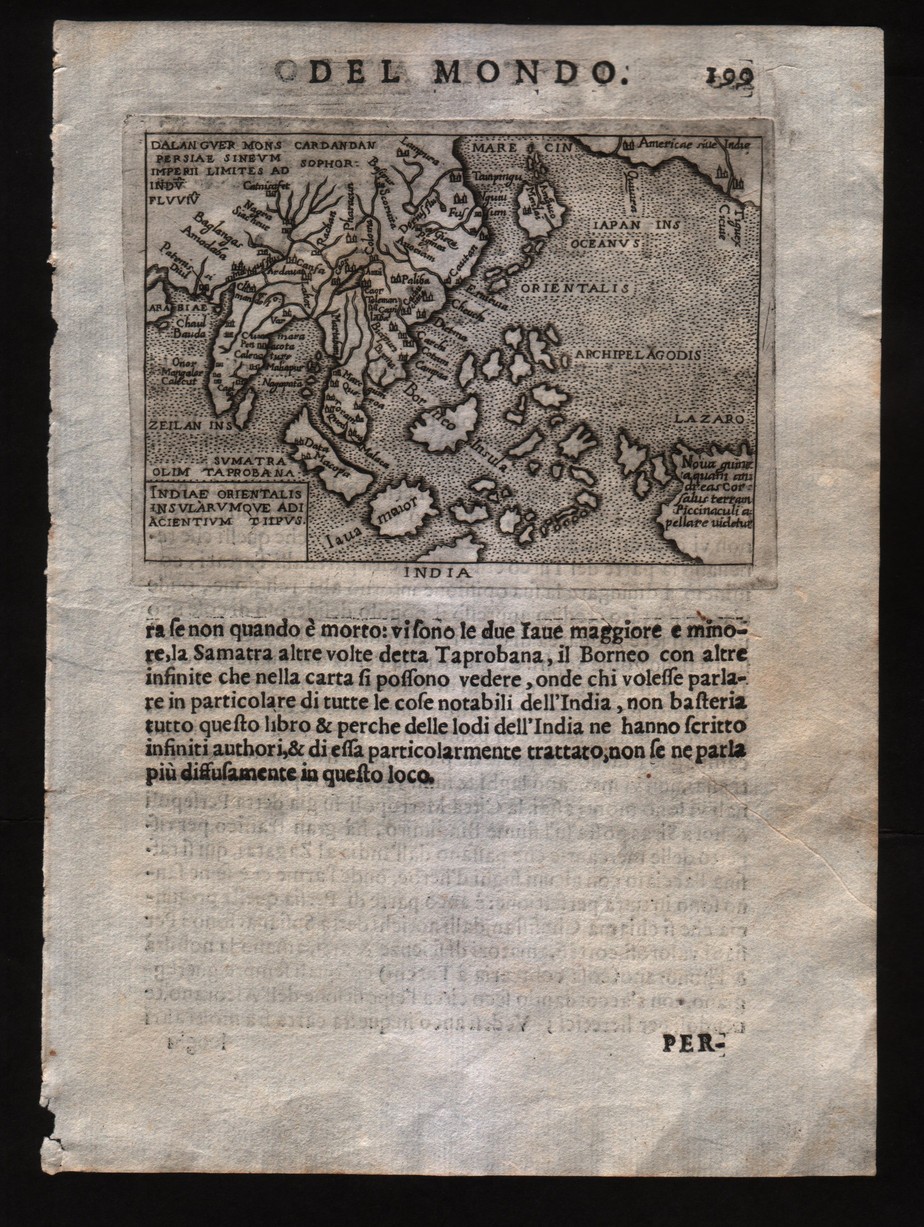
Map title
Indiae orientalis insularumque adiacientium typus
Author
Ortelius
Location shown in map
Southeast Asia
Edition date
1598
Edition place
Brescia
Editor
--
Atlas
Theatro del mondo -- Compania Bresciana
Price
200 Euro
State
[mint/EXCELLENT/very good/good/fair/mediocre/poor]
Color
Black/white
Verso
Italian text pag.199
Size
Plate: cm (11 x 8) inches (4.33 x 3.15) Paper: cm (14 x 19) inches (5.51 x 7.48)
Technique
Copper engraving
Note
No particular notes for this maps.
Reference
--
Wiki
Here for more info
In stock
Available
Info
info@thetreasuremaps.com
Code
#0199
×
![Indiae orientalis insularumque adiacientium typus by Ortelius, Southeast Asia, 1598]()
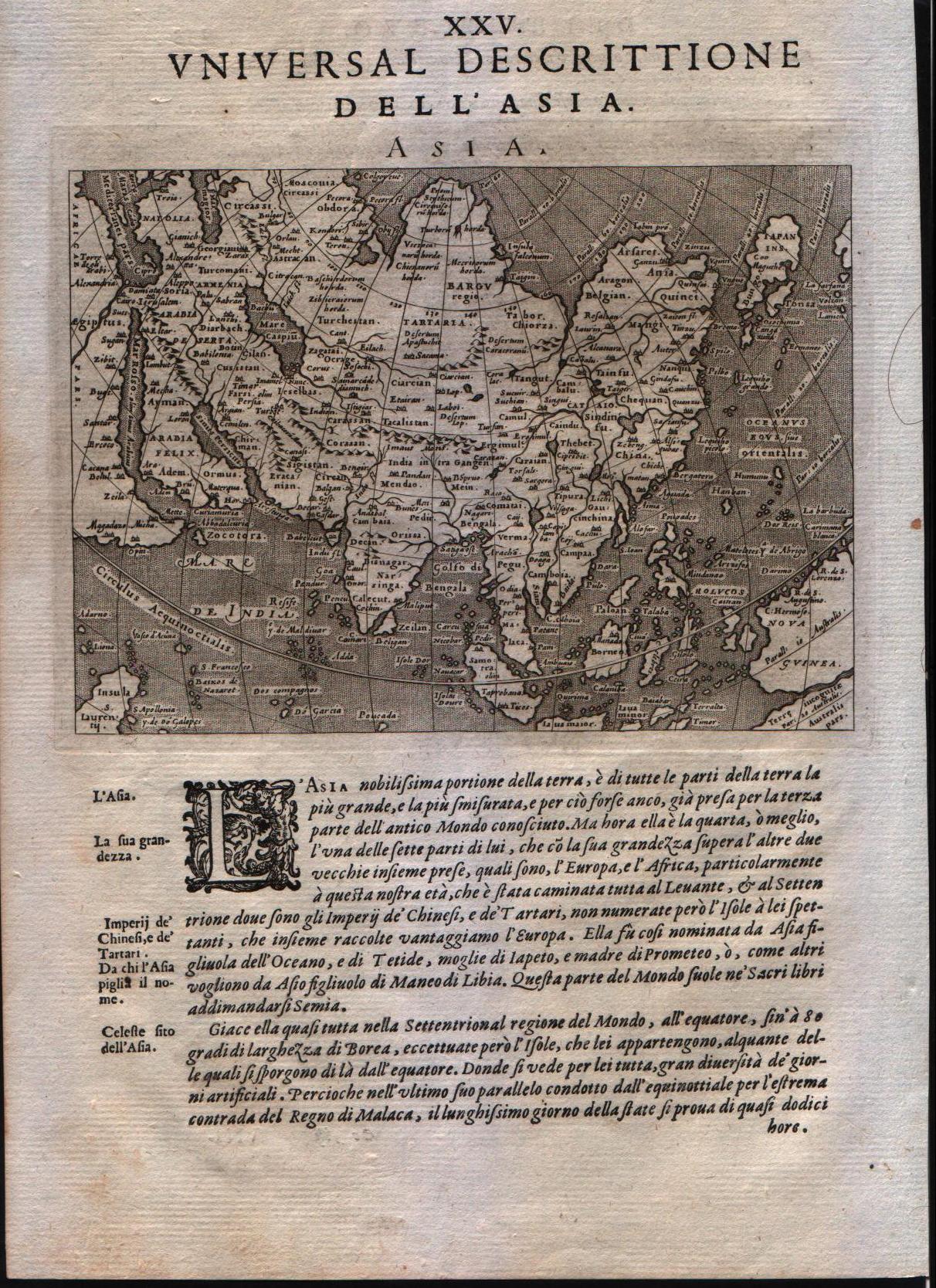
Map title
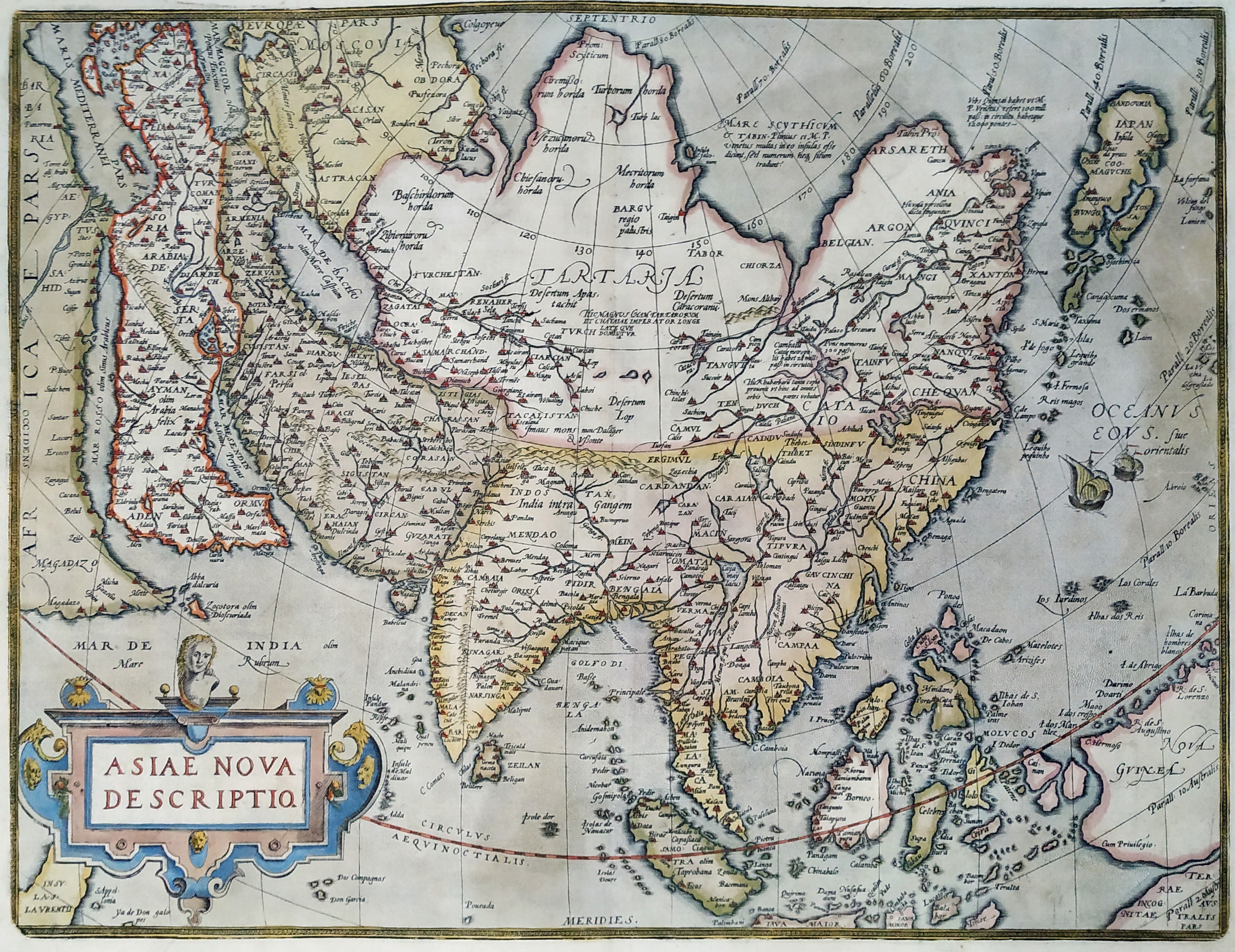
Asiae nova descriptio
Author
Ortelius
Location shown in map
Asia
Edition date
1575
Edition place
Antwerp
Editor
--
Atlas
Theatrum Orbis Terrarum
Price
Please ask: info@thetreasuremaps.com
State
[mint/excellent/VERY GOOD/good/fair/mediocre/poor]
Color
Old color
Verso
Latin text pag.3
Size
Plate: cm (36.8 x 48.3) inches (14.49 x 19.02) Paper: cm (43.2 x 52.1) inches (17.01 x 20.51)
Technique
Copper engraving
Note
No particular notes for this maps.
Reference
Van Den Broecke 7
Wiki
Here for more info
In stock
Available
Info
info@thetreasuremaps.com
Code
#0200
×
![Asiae nova descriptio by Ortelius, Asia, 1575]()
Map title
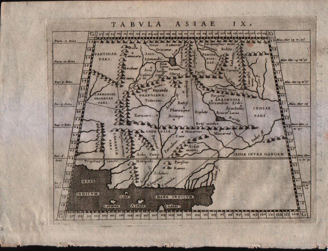
Tabula Asiae IX
Author
Magini
Location shown in map
Pakistan and Afganistan
Edition date
1596
Edition place
Venice
Editor
Heredes Simoni Galignani
Atlas
Geografia di Claudio Tolomeo -- Giovanni Antonio Magini
Price
Euro
State
[MINT/excellent/very good/good/fair/mediocre/poor]
Color
Black/white
Verso
Latin text pag.24
Size
Plate: cm (17.8 x 12.7) inches (7.01 x 5) Paper: cm (22.9 x 16.5) inches (9.02 x 6.5)
Technique
Copper engraving
Note
No particular notes for this maps.
Reference
--
Wiki
Here for more info
In stock
Available
Info
info@thetreasuremaps.com
Code
#0201
×
![Tabula Asiae IX by Magini, Pakistan and Afganistan, 1596]()
Map title
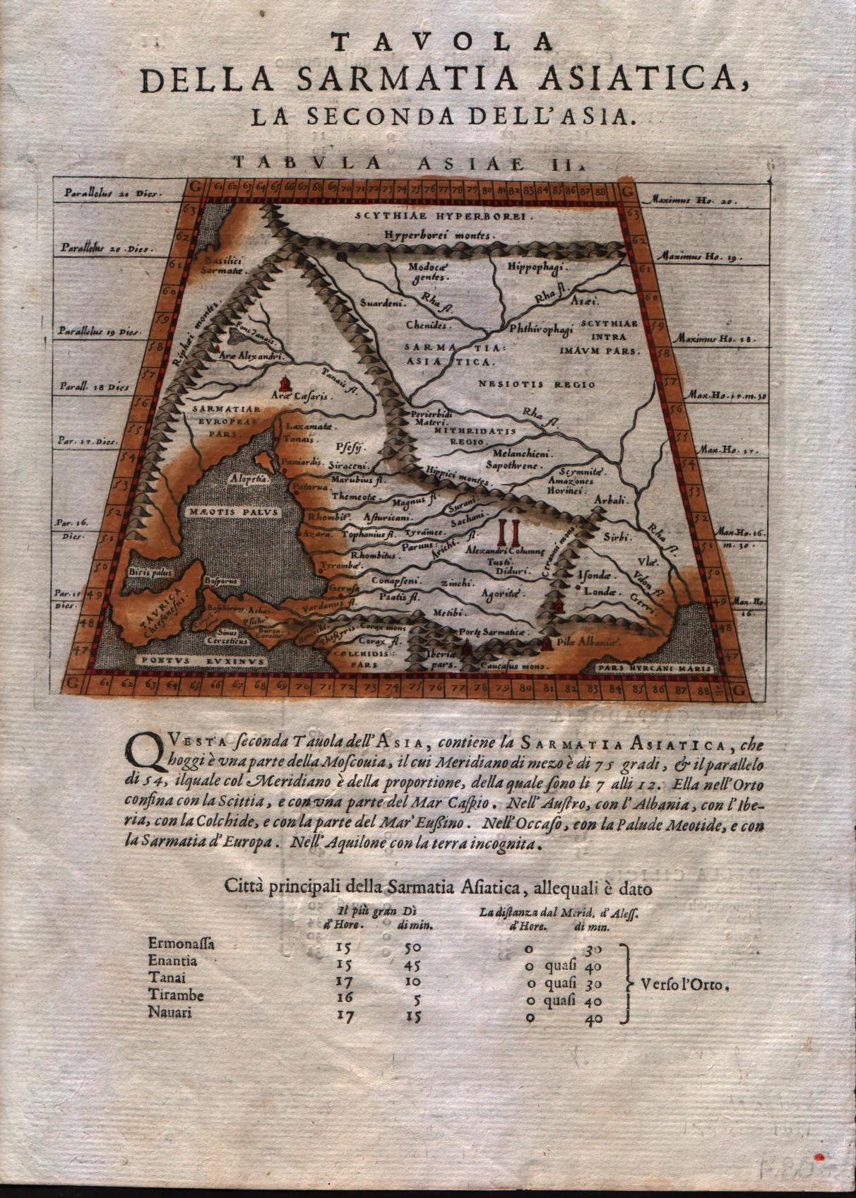
Tabula Asiae II
Author
Magini
Location shown in map
Crimea and sea of Azov
Edition date
1598
Edition place
Venice
Editor
Battista & Giorgio Galignani
Atlas
Geografia di Claudio Tolomeo -- Giovanni Antonio Magini
Price
125 Euro
State
[MINT/excellent/very good/good/fair/mediocre/poor]
Color
Modern color
Verso
Italian text pag.11
Size
Plate: cm (17.8 x 12.7) inches (7.01 x 5) Paper: cm (20.3 x 30.5) inches (7.99 x 12.01)
Technique
Copper engraving
Note
No particular notes for this maps.
Reference
--
Wiki
Here for more info
In stock
Available
Info
info@thetreasuremaps.com
Code
#0202
×
![Tabula Asiae II by Magini, Crimea and sea of Azov, 1598]()
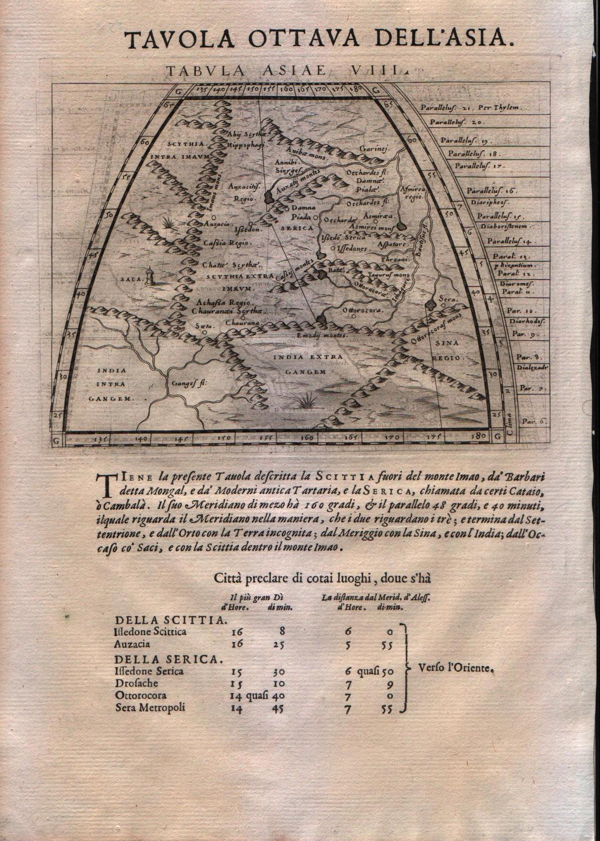
Map title
Tabula Asiae VIII
Author
Magini
Location shown in map
Central Asia
Edition date
1598
Edition place
Venice
Editor
Battista & Giorgio Galignani
Atlas
Geografia di Claudio Tolomeo -- Giovanni Antonio Magini
Price
125 Euro
State
[MINT/excellent/very good/good/fair/mediocre/poor]
Color
Black/white
Verso
Italian text pag.15
Size
Plate: cm (17.8 x 14) inches (7.01 x 5.51) Paper: cm (20.3 x 29.2) inches (7.99 x 11.5)
Technique
Copper engraving
Note
No particular notes for this maps.
Reference
--
Wiki
Here for more info
In stock
Available
Info
info@thetreasuremaps.com
Code
#0203
×
![Tabula Asiae VIII by Magini, Central Asia, 1598]()
Map title
Asia
Author
Magini
Location shown in map
Asia
Edition date
1598
Edition place
Venice
Editor
Battista & Giorgio Galignani
Atlas
Geografia di Claudio Tolomeo -- Giovanni Antonio Magini
Price
500 Euro
State
[MINT/excellent/very good/good/fair/mediocre/poor]
Color
Black/white
Verso
Italian text pag.153
Size
Plate: cm (12.7 x 17.8) inches (5 x 7.01) Paper: cm (20.3 x 30.5) inches (7.99 x 12.01)
Technique
Copper engraving
Note
No particular notes for this maps.
Reference
--
Wiki
Here for more info
In stock
Available
Info
info@thetreasuremaps.com
Code
#0204
Asia
Author
Magini
Location shown in map
Asia
Edition date
1598
Edition place
Venice
Editor
Battista & Giorgio Galignani
Atlas
Geografia di Claudio Tolomeo -- Giovanni Antonio Magini
Price
500 Euro
State
[MINT/excellent/very good/good/fair/mediocre/poor]
Color
Black/white
Verso
Italian text pag.153
Size
Plate: cm (12.7 x 17.8) inches (5 x 7.01) Paper: cm (20.3 x 30.5) inches (7.99 x 12.01)
Technique
Copper engraving
Note
No particular notes for this maps.
Reference
--
Wiki
Here for more info
In stock
Available
Info
info@thetreasuremaps.com
Code
#0204
×
![Asia by Magini, Asia, 1598]()
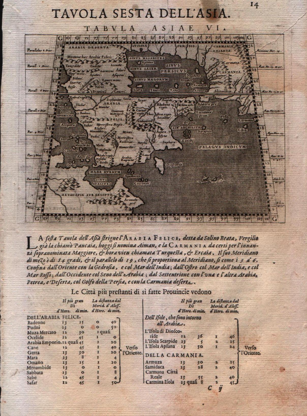
Map title
Tabula Asiae VI
Author
Magini
Location shown in map
Arabia
Edition date
1598
Edition place
Venice
Editor
Battista & Giorgio Galignani
Atlas
Geografia di Claudio Tolomeo -- Giovanni Antonio Magini
Price
125 Euro
State
[MINT/excellent/very good/good/fair/mediocre/poor]
Color
Black/white
Verso
Italian text pag.14
Size
Plate: cm (12.7 x 17.8) inches (5 x 7.01) Paper: cm (20.3 x 30.5) inches (7.99 x 12.01)
Technique
Copper engraving
Note
Ptolemaic map of the region.
Reference
--
Wiki
Here for more info
In stock
Available
Info
info@thetreasuremaps.com
Code
#0205
×
![Tabula Asiae VI by Magini, Arabia, 1598]()
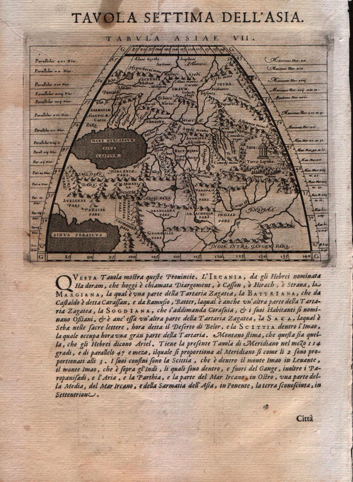
Map title
Tabula Asiae VII
Author
Magini
Location shown in map
Iran,Iraq,Armenia
Edition date
1598
Edition place
Venice
Editor
Battista & Giorgio Galignani
Atlas
Geografia di Claudio Tolomeo -- Giovanni Antonio Magini
Price
125 Euro
State
[MINT/excellent/very good/good/fair/mediocre/poor]
Color
Black/white
Verso
Italian text pag.14
Size
Plate: cm (12.7 x 17.8) inches (5 x 7.01) Paper: cm (20.3 x 30.5) inches (7.99 x 12.01)
Technique
Copper engraving
Note
Ptolemaic map of the region.
Reference
--
Wiki
Here for more info
In stock
Available
Info
info@thetreasuremaps.com
Code
#0206
×
![Tabula Asiae VII by Magini, Iran,Iraq,Armenia, 1598]()
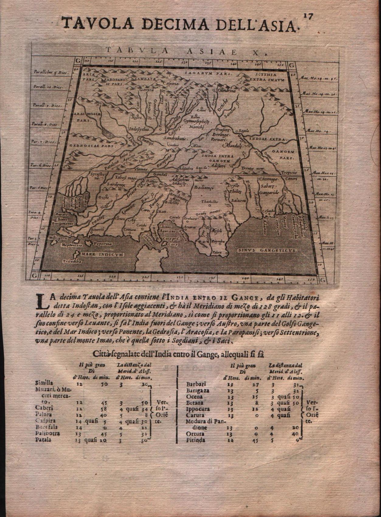
Map title
Tabula Asiae X
Author
Magini
Location shown in map
India
Edition date
1621
Edition place
Padova
Editor
Paolo and Francesco Galignani
Atlas
Geografia di Claudio Tolomeo -- Giovanni Antonio Magini
Price
125 Euro
State
[MINT/excellent/very good/good/fair/mediocre/poor]
Color
Black/white
Verso
Italian text
Size
Plate: cm (12.7 x 17.8) inches (5 x 7.01) Paper: cm (20.3 x 30.5) inches (7.99 x 12.01)
Technique
Copper engraving
Note
--
Reference
--
Wiki
Here for more info
In stock
Available
Info
info@thetreasuremaps.com
Code
#0207
×
![Tabula Asiae X by Magini, India, 1621]()
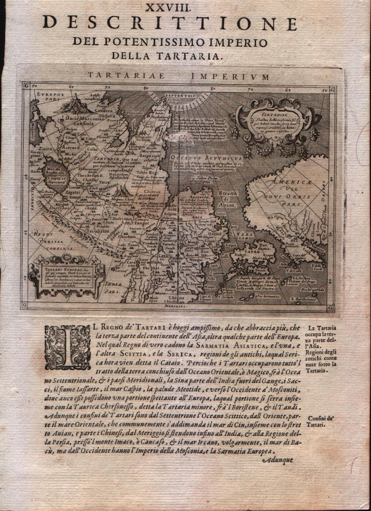
Map title
Descrittione del potentissimo imperio della Tartaria
Author
Magini
Location shown in map
East Asia, Japan, California
Edition date
1598
Edition place
Venice
Editor
Battista & Giorgio Galignani
Atlas
Geografia di Claudio Tolomeo -- Giovanni Antonio Magini
Price
350 Euro
State
[MINT/excellent/very good/good/fair/mediocre/poor]
Color
Black/white
Verso
Italian text
Size
Plate: cm (12.7 x 17.8) inches (5 x 7.01) Paper: cm (20.3 x 30.5) inches (7.99 x 12.01)
Technique
Copper engraving
Note
Very interesting map of East Asia and North West America.
Reference
--
Wiki
Here for more info
In stock
Available
Info
info@thetreasuremaps.com
Code
#0208
×
![Descrittione del potentissimo imperio della Tartaria by Magini, East Asia, Japan, California, 1598]()
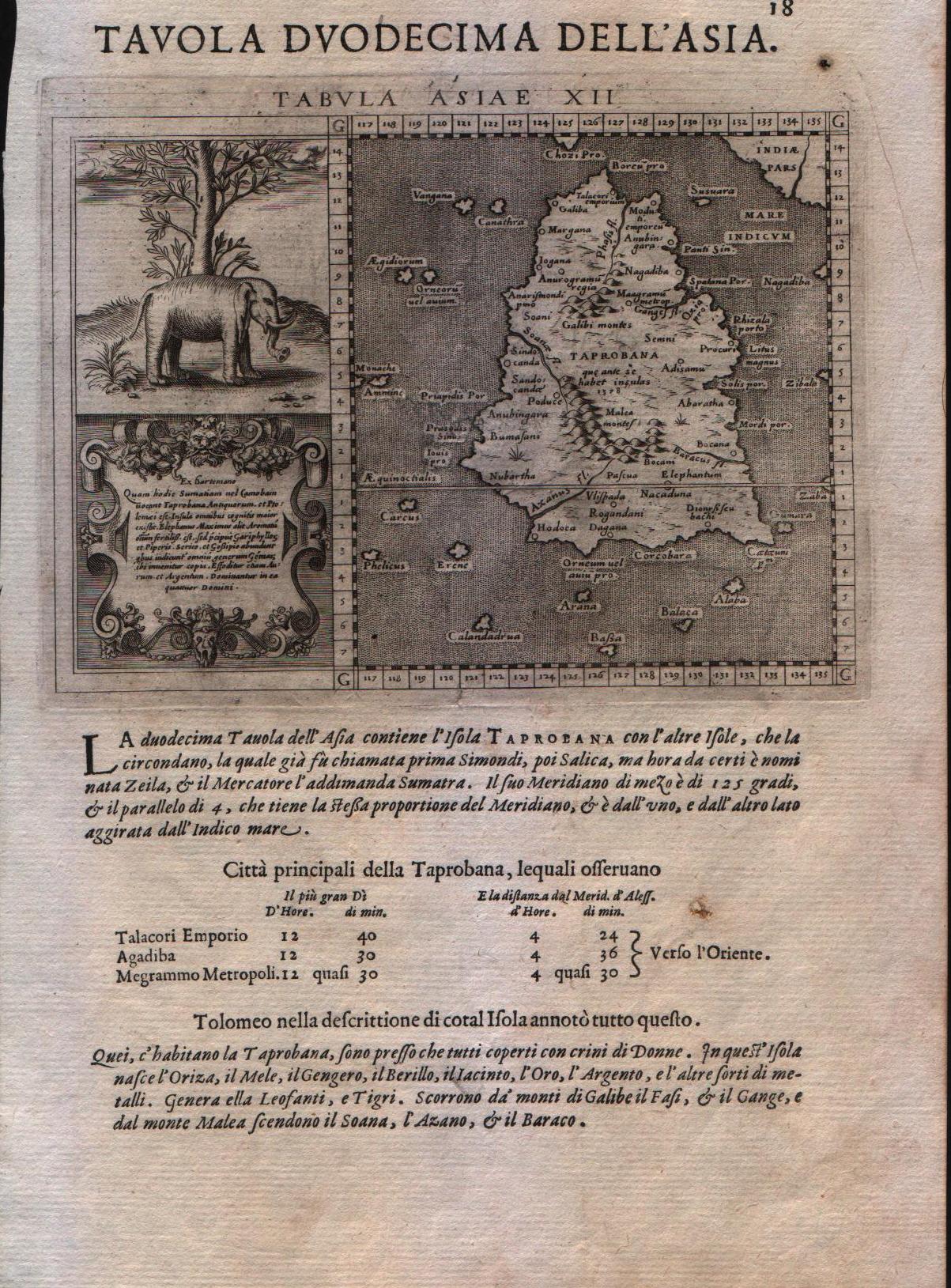
Map title
Tavola duodecima dell'Asia
Author
Magini
Location shown in map
Ceylon
Edition date
1598
Edition place
Venice
Editor
Battista & Giorgio Galignani
Atlas
Geografia di Claudio Tolomeo -- Giovanni Antonio Magini
Price
250 Euro
State
[MINT/excellent/very good/good/fair/mediocre/poor]
Color
Black/white
Verso
Italian text
Size
Plate: cm (12.7 x 17.8) inches (5 x 7.01) Paper: cm (20.3 x 30.5) inches (7.99 x 12.01)
Technique
Copper engraving
Note
With large elephant vignette. Tabulae Asiae XII.
Reference
--
Wiki
Here for more info
In stock
Available
Info
info@thetreasuremaps.com
Code
#0209
×
![Tavola duodecima dell'Asia by Magini, Ceylon, 1598]()
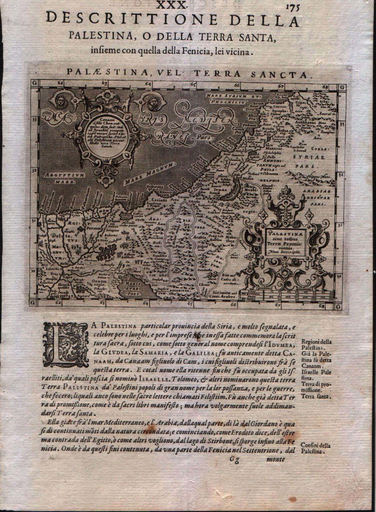
Map title
Palestina vel Terra Sancta
Author
Magini
Location shown in map
Holy Land
Edition date
1598
Edition place
Venice
Editor
Battista & Giorgio Galignani
Atlas
Geografia di Claudio Tolomeo -- Giovanni Antonio Magini
Price
200 Euro
State
[MINT/excellent/very good/good/fair/mediocre/poor]
Color
Black/white
Verso
Italian text pag 175
Size
Plate: cm (12.7 x 17.8) inches (5 x 7.01) Paper: cm (20.3 x 30.5) inches (7.99 x 12.01)
Technique
Copper engraving
Note
Magini's modern map of the Holy Land.
Reference
--
Wiki
Here for more info
In stock
Available
Info
info@thetreasuremaps.com
Code
#0210
×
![Palestina vel Terra Sancta by Magini, Holy Land, 1598]()
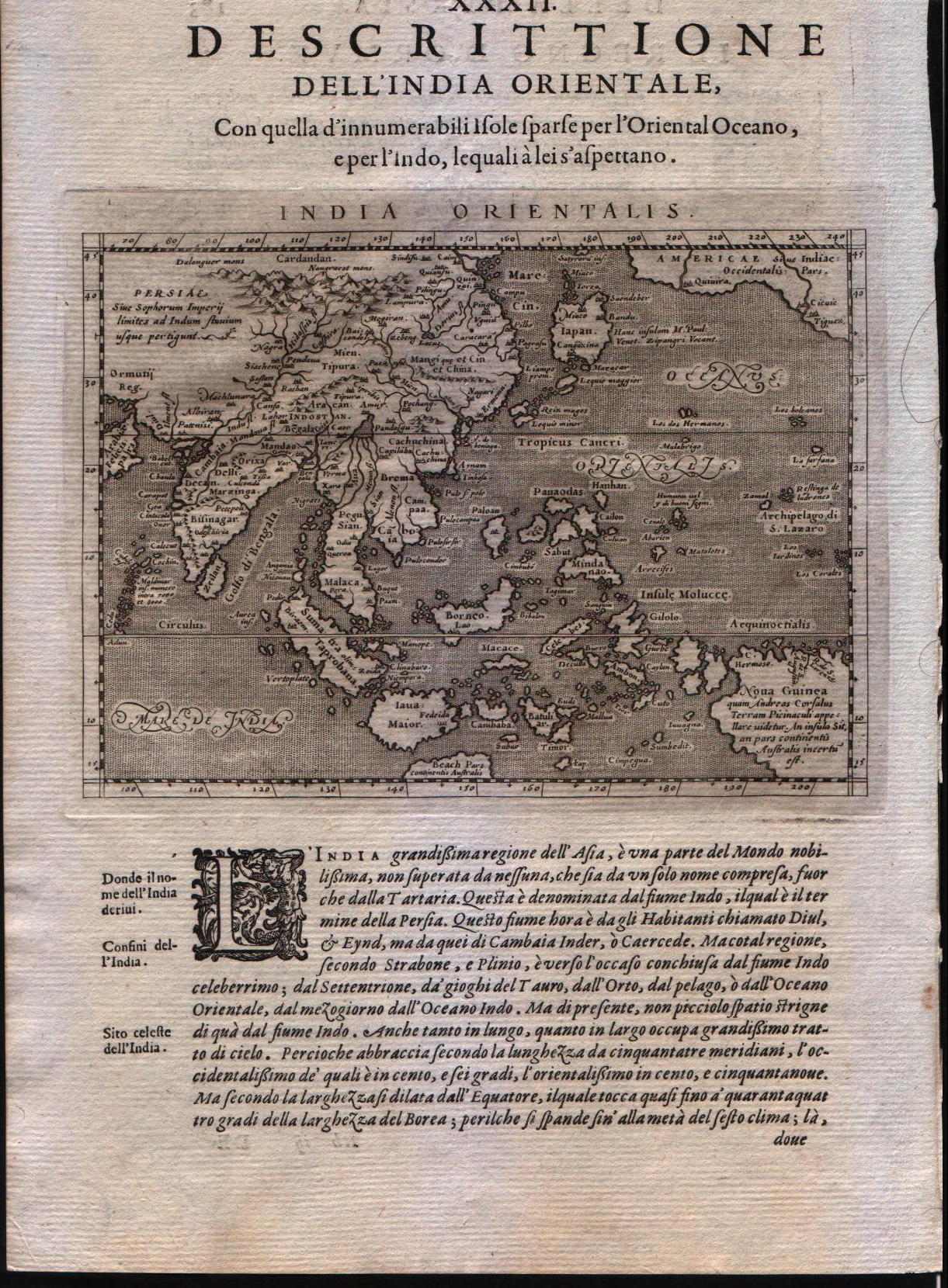
Map title
India orientalis
Author
Magini
Location shown in map
Southest Asia
Edition date
1598
Edition place
Venice
Editor
Battista & Giorgio Galignani
Atlas
Geografia di Claudio Tolomeo -- Giovanni Antonio Magini
Price
350 Euro
State
[MINT/excellent/very good/good/fair/mediocre/poor]
Color
Black/white
Verso
Italian text pag.183
Size
Plate: cm (12.7 x 17.8) inches (5 x 7.01) Paper: cm (20.3 x 30.5) inches (7.99 x 12.01)
Technique
Copper engraving
Note
The Far East.
Reference
--
Wiki
Here for more info
In stock
Available
Info
info@thetreasuremaps.com
Code
#0211
×
![India orientalis by Magini, Southest Asia, 1598]()
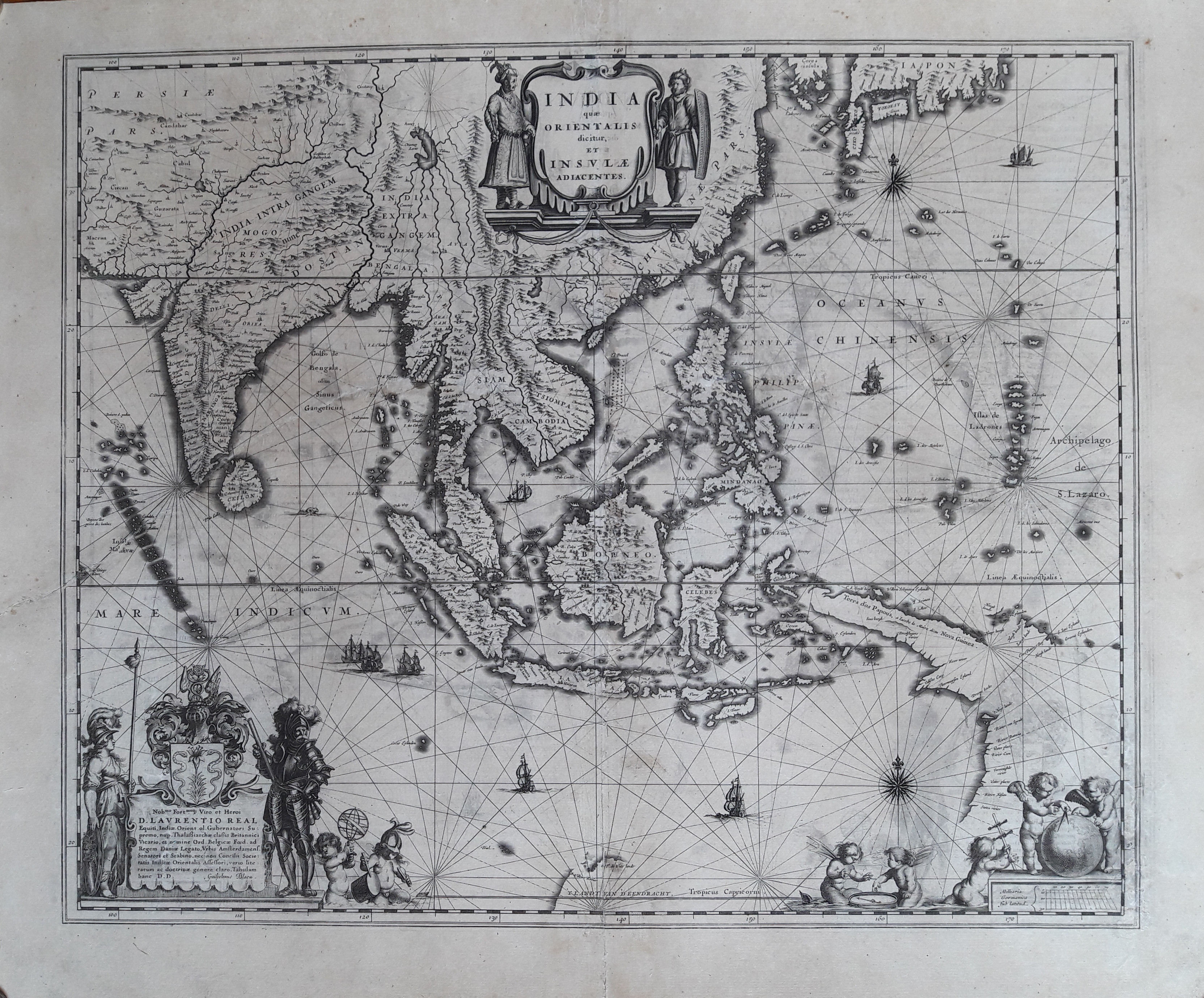
Map title
India que orientalis dicitur et insulae adiacentis
Author
Blaeu
Location shown in map
Southest Asia
Edition date
1635
Edition place
Amsterdam
Editor
--
Atlas
Theatrum Orbis Terrarum, Sive Atlas Novis
Price
1600 Euro
State
[mint/excellent/VERY GOOD/good/fair/mediocre/poor]
Color
Black/white
Verso
Latin text pag.2
Size
Plate: cm (50.8 x 40.6) inches (20 x 15.98) Paper: cm (58.4 x 45.7) inches (22.99 x 17.99)
Technique
Copper engraving
Note
Professionally restored
Reference
--
Wiki
Here for more info
In stock
Available
Info
info@thetreasuremaps.com
Code
#0212
×
![India que orientalis dicitur et insulae adiacentis by Blaeu, Southest Asia, 1635]()
Map title
Asia
Author
Munster
Location shown in map
Asia
Edition date
1628
Edition place
Basel
Editor
Henrich Petri
Atlas
Cosmographia Universalis
Price
600 Euro
State
[mint/excellent/VERY GOOD/good/fair/mediocre/poor]
Color
Black/white
Verso
German text
Size
Plate: cm (35.6 x 30.5) inches (14.02 x 12.01) Paper: cm (43.2 x 36.8) inches (17.01 x 14.49)
Technique
Woodcut
Note
--
Reference
--
Wiki
Here for more info
In stock
Available
Info
info@thetreasuremaps.com
Code
#0213
Asia
Author
Munster
Location shown in map
Asia
Edition date
1628
Edition place
Basel
Editor
Henrich Petri
Atlas
Cosmographia Universalis
Price
600 Euro
State
[mint/excellent/VERY GOOD/good/fair/mediocre/poor]
Color
Black/white
Verso
German text
Size
Plate: cm (35.6 x 30.5) inches (14.02 x 12.01) Paper: cm (43.2 x 36.8) inches (17.01 x 14.49)
Technique
Woodcut
Note
--
Reference
--
Wiki
Here for more info
In stock
Available
Info
info@thetreasuremaps.com
Code
#0213
×
![Asia by Munster, Asia, 1628]()
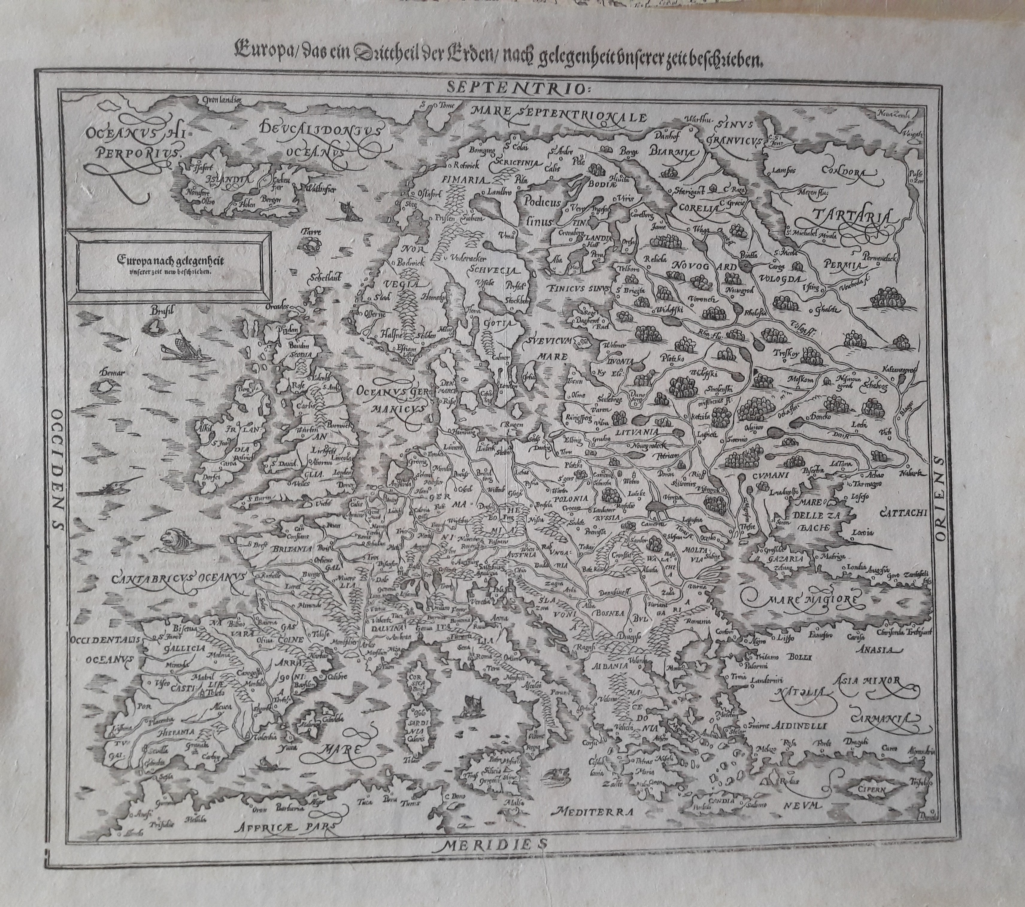
Map title
Europe
Author
Munster
Location shown in map
Europe
Edition date
1578
Edition place
Basel
Editor
Henrich Petri
Atlas
Cosmographia Universalis
Price
400 Euro
State
[mint/excellent/VERY GOOD/good/fair/mediocre/poor]
Color
Black/white
Verso
German text
Size
Plate: cm (35.6 x 30.5) inches (14.02 x 12.01) Paper: cm (43.2 x 36.8) inches (17.01 x 14.49)
Technique
Woodcut
Note
--
Reference
--
Wiki
Here for more info
In stock
Available
Info
info@thetreasuremaps.com
Code
#0214
Europe
Author
Munster
Location shown in map
Europe
Edition date
1578
Edition place
Basel
Editor
Henrich Petri
Atlas
Cosmographia Universalis
Price
400 Euro
State
[mint/excellent/VERY GOOD/good/fair/mediocre/poor]
Color
Black/white
Verso
German text
Size
Plate: cm (35.6 x 30.5) inches (14.02 x 12.01) Paper: cm (43.2 x 36.8) inches (17.01 x 14.49)
Technique
Woodcut
Note
--
Reference
--
Wiki
Here for more info
In stock
Available
Info
info@thetreasuremaps.com
Code
#0214
×
![Europe by Munster, Europe, 1578]()
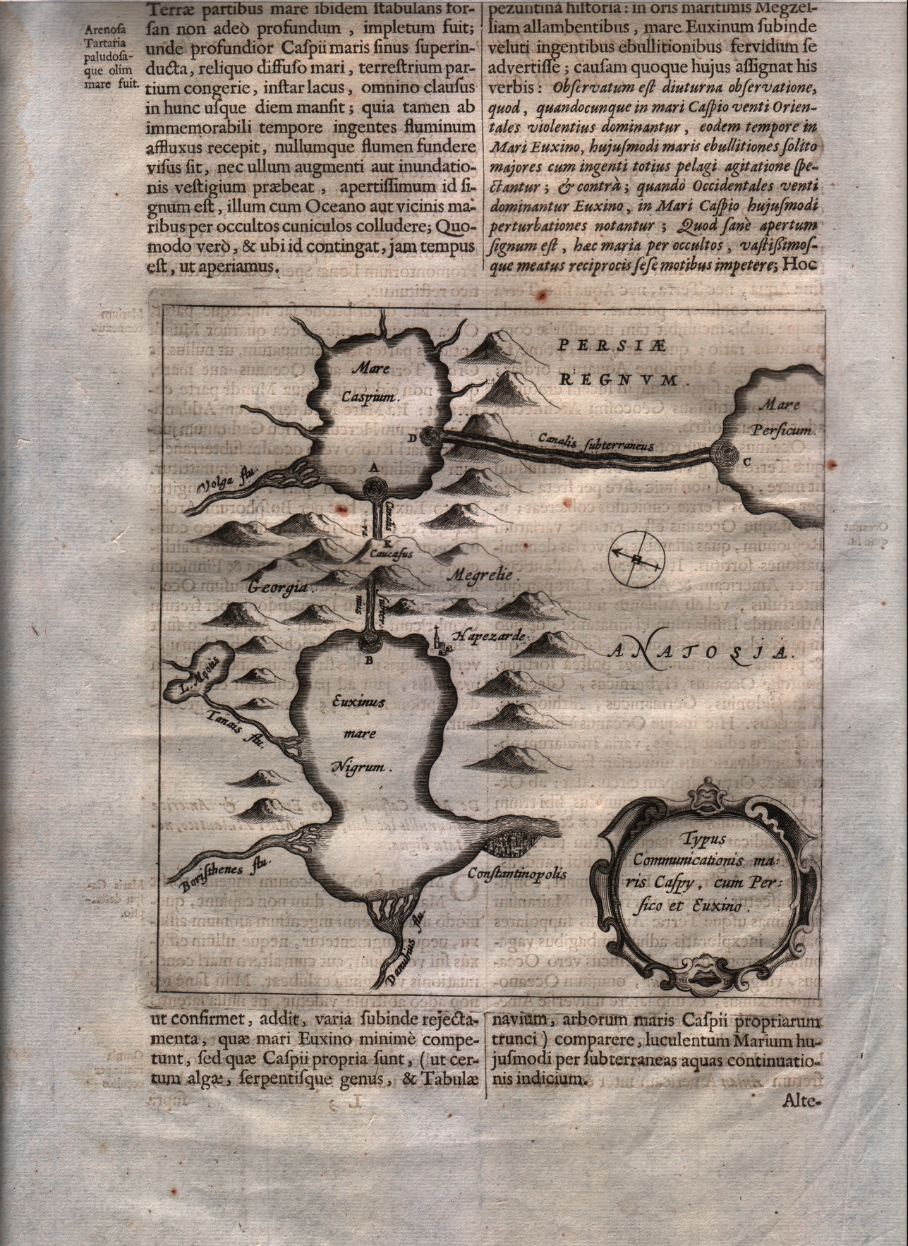
Map title
Typus communicationis Maris Caspy, cum Persico et Euxino.
Author
Kircher
Location shown in map
Black sea & Caspian sea
Edition date
1665
Edition place
Editor
--
Atlas
Mundus Subterraneus
Price
200 Euro
State
[mint/EXCELLENT/very good/good/fair/mediocre/poor]
Color
Black/white
Verso
Latin text
Size
Plate: cm (16.5 x 16.5) inches (6.5 x 6.5) Paper: cm (24.1 x 38.1) inches (9.49 x 15)
Technique
Copper engraving
Note
--
Reference
--
Wiki
Here for more info
In stock
Available
Info
info@thetreasuremaps.com
Code
#0216
×
![Typus communicationis Maris Caspy, cum Persico et Euxino. by Kircher, Black sea & Caspian sea, 1665]()
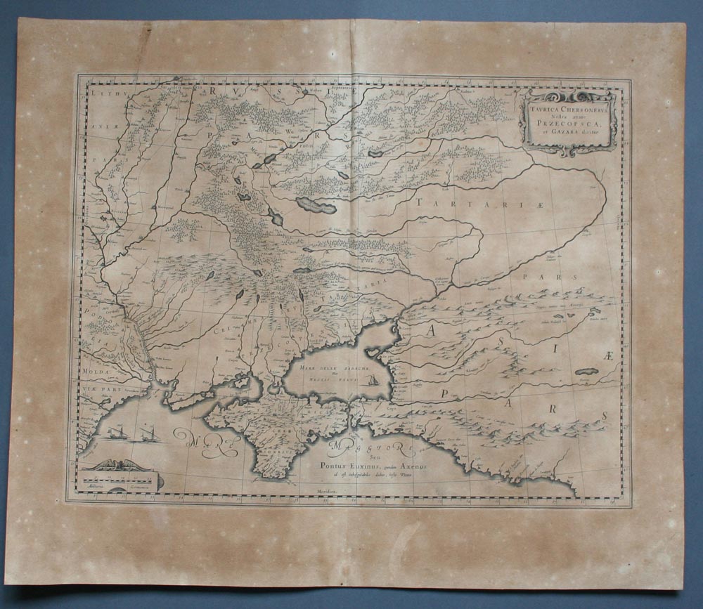
Map title
Taurica Chersonesus. Nostra aetate Przecopsca, et Gazara dicitur.
Author
Blaeu
Location shown in map
Russia and Black sea
Edition date
1645
Edition place
Amsterdam
Editor
--
Atlas
Theatrum Orbis Terrarum, Sive Atlas Novis
Price
200 Euro
State
[mint/excellent/VERY GOOD/good/fair/mediocre/poor]
Color
Black/white
Verso
Latin text
Size
Plate: cm (48.3 x 35.6) inches (19.02 x 14.02) Paper: cm (58.4 x 50.8) inches (22.99 x 20)
Technique
Copper engraving
Note
No particular notes for this maps
Reference
--
Wiki
Here for more info
In stock
Available
Info
info@thetreasuremaps.com
Code
#0217
×
![Taurica Chersonesus. Nostra aetate Przecopsca, et Gazara dicitur. by Blaeu, Russia and Black sea, 1645]()
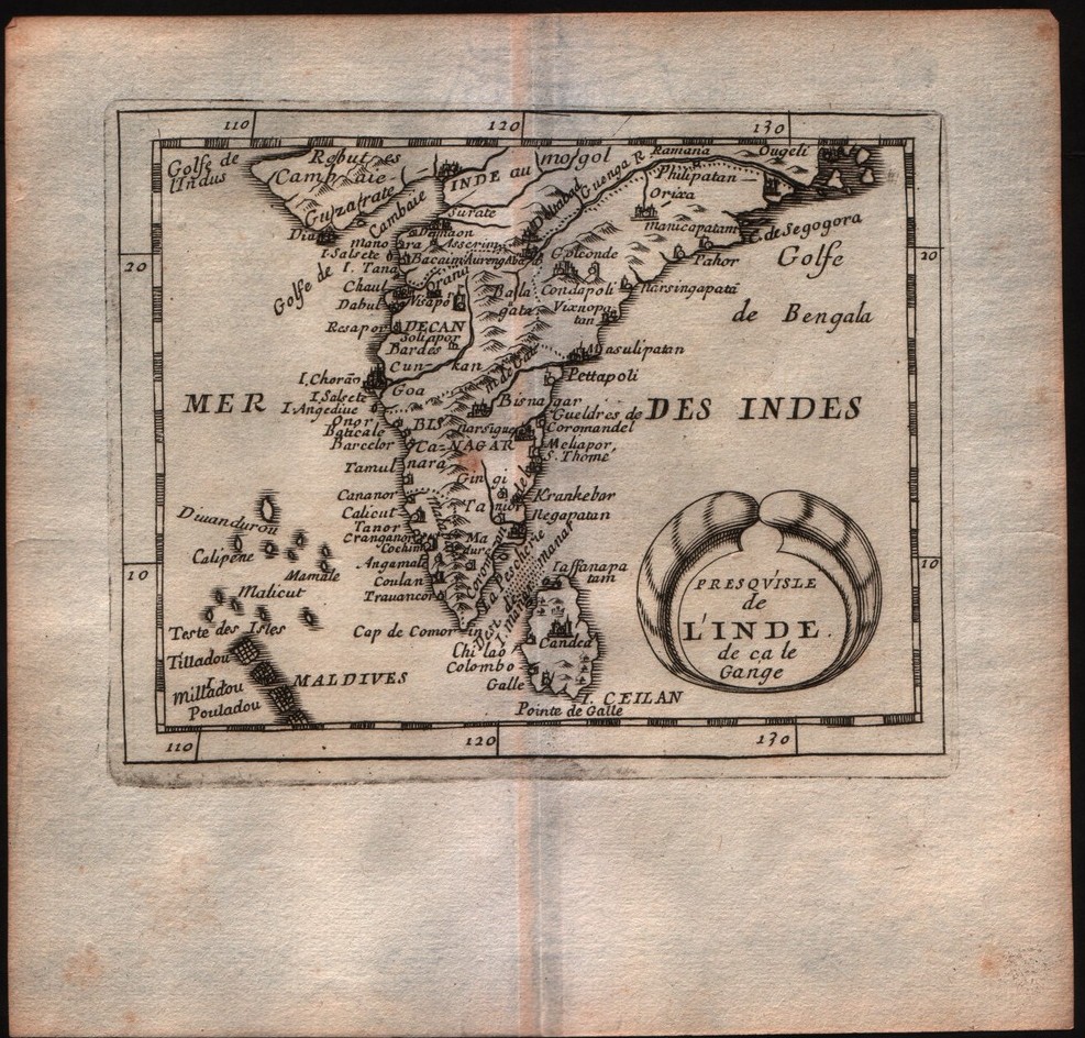
Map title
Presquisle de l'Inde de ca le Gange
Author
DuVal
Location shown in map
India
Edition date
1682
Edition place
Paris
Editor
--
Atlas
La geographie universelle - P. Du Val d'Abbeville
Price
100 Euro
State
[mint/EXCELLENT/very good/good/fair/mediocre/poor]
Color
Black/white
Verso
Blank
Size
Plate: cm (12.7 x 10.2) inches (5 x 4.02) Paper: cm (16.5 x 16.5) inches (6.5 x 6.5)
Technique
Copper engraving
Note
No particular notes for this maps
Reference
--
Wiki
Here for more info
In stock
Available
Info
info@thetreasuremaps.com
Code
#0218
×
![Presquisle de l'Inde de ca le Gange by DuVal, India, 1682]()
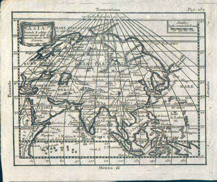
Map title
Asia, secondo le ultime osservazioni dell'accademia reale delle scienze
Author
Buffier
Location shown in map
Asia
Edition date
1790
Edition place
Rome
Editor
--
Atlas
Geographie universelle, italian edition.
Price
75 Euro
State
[mint/EXCELLENT/very good/good/fair/mediocre/poor]
Color
Black/white
Verso
Blank
Size
Plate: cm (17.8 x 13.3) inches (7.01 x 5.24) Paper: cm (19.7 x 16.5) inches (7.76 x 6.5)
Technique
Copper engraving
Note
Claude Buffier was a Jesuit theologian and geographer working in Paris, who wrote the Geographie Universelle, first issued in about 1715. The Geographie was issued as a pocket-sized volume, illustrated with a set of maps.The volume proved very popular, and numerous editions were published in Paris, Naples and Rome. The book was evidently targeted at the popular market, and for this reason examples of the book tend to be printed on relatively poor quality paper, and this is particularly true of the Italian editions.Evidently there were a large number of different sets of map plates used - so far 17 different plates or states of plates have been identified for the Americas map, some engraved anonymously, and other signed by Hendrick van Loon, Faure, Denise Macquart and Dom. Dell'Acerra Unfortunately, it has been frequent practice to disperse such volumes, so the origin of several of these plates has not yet been identified, and the editor would be grateful to hear from readers about editions of the book, particularly those containing maps engraved by Denise Macquart and Dom. Dell'Acerra.[http://www.mapforum.com]
Reference
--
Wiki
Here for more info
In stock
Available
Info
info@thetreasuremaps.com
Code
#0220
×
![Asia, secondo le ultime osservazioni dell'accademia reale delle scienze by Buffier, Asia, 1790]()