News
Map title
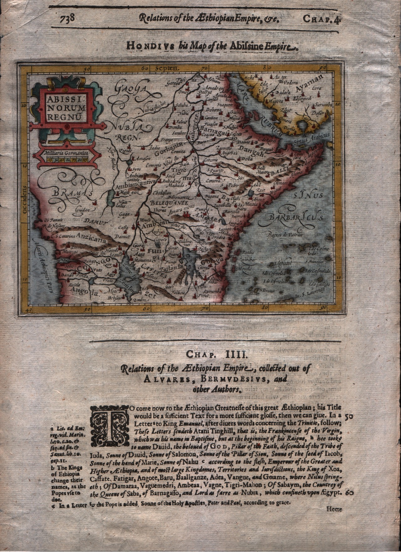
Abissinorum regnum
Author
Mercator
Location shown in map
East Africa
Edition date
1625
Edition place
London
Editor
--
Atlas
Purchas his Pilgrimes
Price
250 Euro
State
[mint/EXCELLENT/very good/good/fair/mediocre/poor]
Color
Modern colors
Verso
English text
Size
Plate: cm (17.8 x 14) inches (7.01 x 5.51) Paper: cm (21.6 x 33) inches (8.5 x 12.99)
Technique
Copper engraving
Note
No particular notes for this maps
Reference
--
Wiki
Here for more info
In stock
Available
Info
info@thetreasuremaps.com
Code
#0293
×
![Abissinorum regnum by Mercator, East Africa, 1625]()
Map title
Guinea
Author
Blaeu
Location shown in map
Gulf of Guinea
Edition date
1635
Edition place
Amsterdam
Editor
--
Atlas
Theatrum Orbis Terrarum, Sive Atlas Novis
Price
Please ask: info@thetreasuremaps.com
State
[mint/excellent/very good/GOOD/fair/mediocre/poor]
Color
Black/white
Verso
Franch text pag.4
Size
Plate: cm (53.3 x 38.1) inches (20.98 x 15) Paper: cm (61 x 50.8) inches (24.02 x 20)
Technique
Copper engraving
Note
No particular notes for this maps
Reference
--
Wiki
Here for more info
In stock
Available
Info
info@thetreasuremaps.com
Code
#0294
×
![Guinea by Blaeu, Gulf of Guinea , 1635]()
Map title
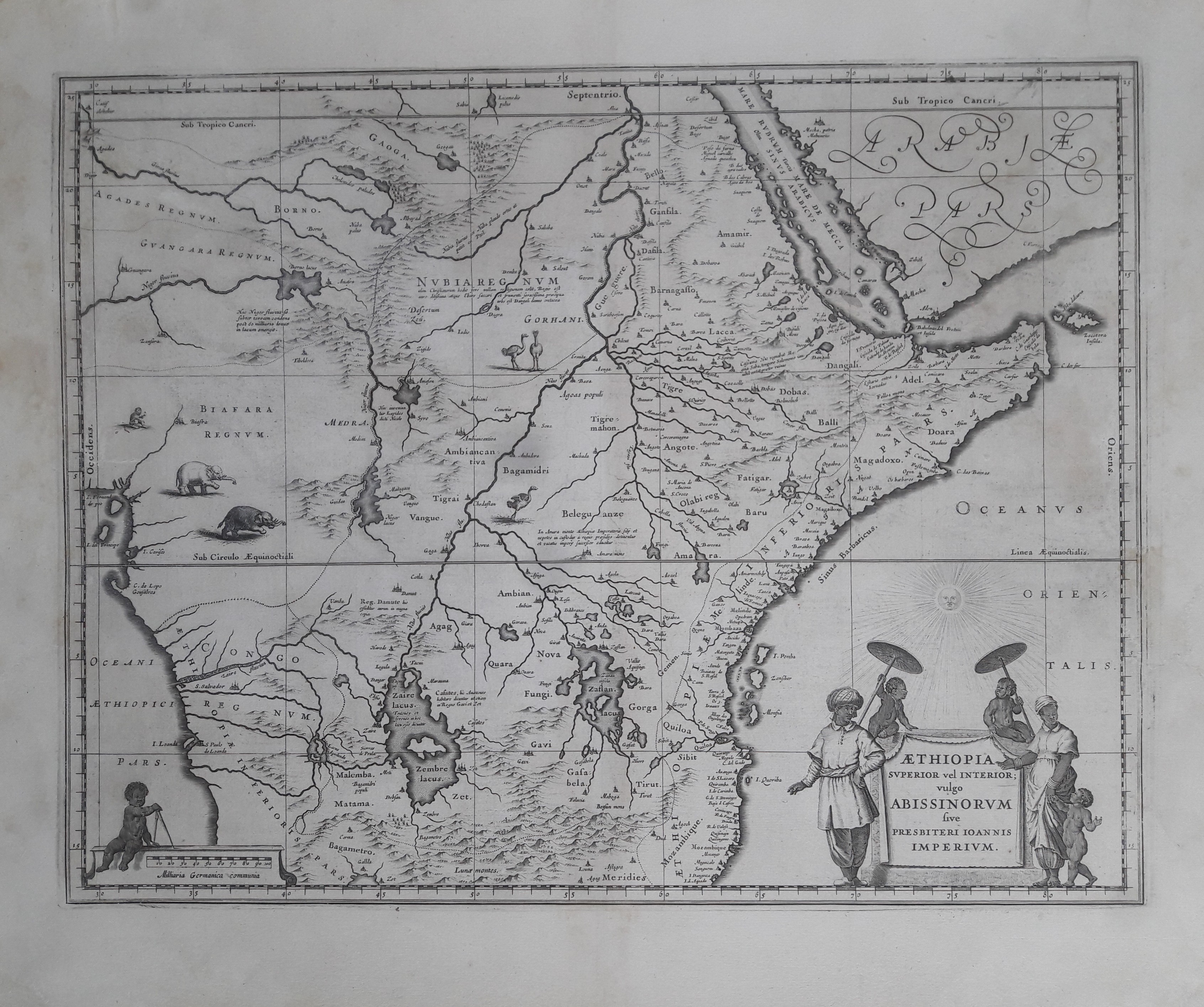
Aethiopia superior vel inferior
Author
Blaeu
Location shown in map
East Africa
Edition date
1635
Edition place
Amsterdam
Editor
--
Atlas
Theatrum Orbis Terrarum, Sive Atlas Novis
Price
Please ask: info@thetreasuremaps.com
State
[mint/excellent/very good/GOOD/fair/mediocre/poor]
Color
Black/white
Verso
Franch text pag.5
Size
Plate: cm (50.8 x 38.1) inches (20 x 15) Paper: cm (61 x 48.3) inches (24.02 x 19.02)
Technique
Copper engraving
Note
No particular notes for this maps
Reference
--
Wiki
Here for more info
In stock
Available
Info
info@thetreasuremaps.com
Code
#0295
×
![Aethiopia superior vel inferior by Blaeu, East Africa, 1635]()
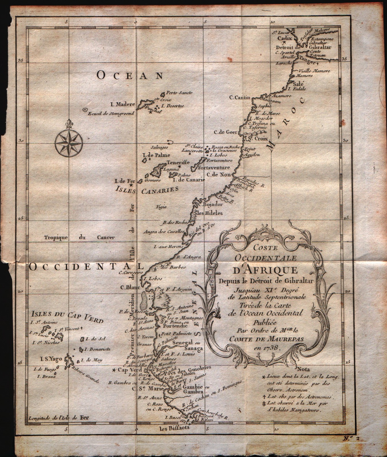
Map title
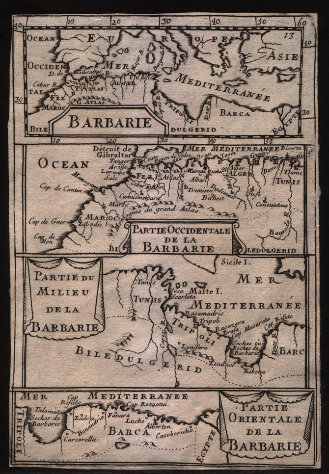
Barbarie
Author
Mallet
Location shown in map
North Africa
Edition date
1683
Edition place
--
Editor
--
Atlas
Description de l'Univers
Price
50 Euro
State
[mint/EXCELLENT/very good/good/fair/mediocre/poor]
Color
Black/white
Verso
Blank
Size
Plate: cm (10.2 x 15.2) inches (4.02 x 5.98) Paper: cm (10.2 x 15.2) inches (4.02 x 5.98)
Technique
Copper engraving
Note
No particular notes for this maps
Reference
--
Wiki
Here for more info
In stock
Available
Info
info@thetreasuremaps.com
Code
#0296
×
![Barbarie by Mallet, North Africa, 1683]()
Map title
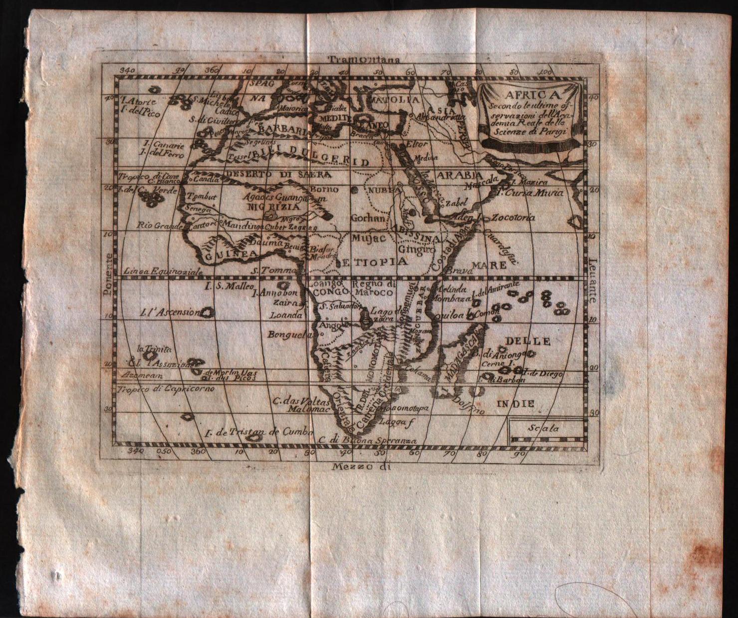
Africa, secondo le ultime osservazioni dell'accademia reale delle scienze
Author
Buffier
Location shown in map
Africa
Edition date
1790
Edition place
Rome
Editor
--
Atlas
Geographie universelle, italian edition.
Price
125 Euro
State
[mint/EXCELLENT/very good/good/fair/mediocre/poor]
Color
Black/white
Verso
Blank
Size
Plate: cm (17.8 x 14) inches (7.01 x 5.51) Paper: cm (24.1 x 20.3) inches (9.49 x 7.99)
Technique
Copper engraving
Note
Claude Buffier was a Jesuit theologian and geographer working in Paris, who wrote the Geographie Universelle, first issued in about 1715. The Geographie was issued as a pocket-sized volume, illustrated with a set of maps.The volume proved very popular, and numerous editions were published in Paris, Naples and Rome. The book was evidently targeted at the popular market, and for this reason examples of the book tend to be printed on relatively poor quality paper, and this is particularly true of the Italian editions.Evidently there were a large number of different sets of map plates used - so far 17 different plates or states of plates have been identified for the Americas map, some engraved anonymously, and other signed by Hendrick van Loon, Faure, Denise Macquart and Dom. Dell'Acerra Unfortunately, it has been frequent practice to disperse such volumes, so the origin of several of these plates has not yet been identified, and the editor would be grateful to hear from readers about editions of the book, particularly those containing maps engraved by Denise Macquart and Dom. Dell'Acerra.
Reference
--
Wiki
Here for more info
In stock
Available
Info
info@thetreasuremaps.com
Code
#0298
×
![Africa, secondo le ultime osservazioni dell'accademia reale delle scienze by Buffier, Africa, 1790]()
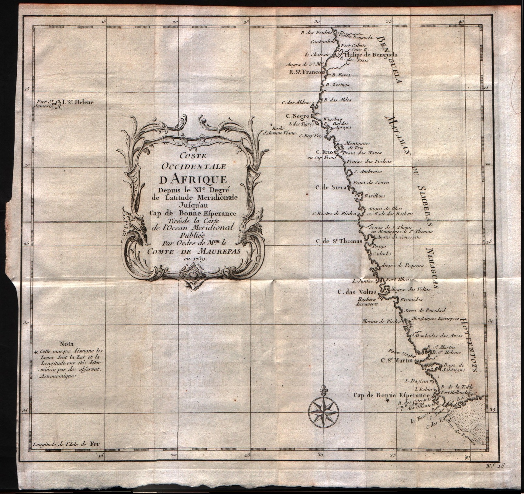
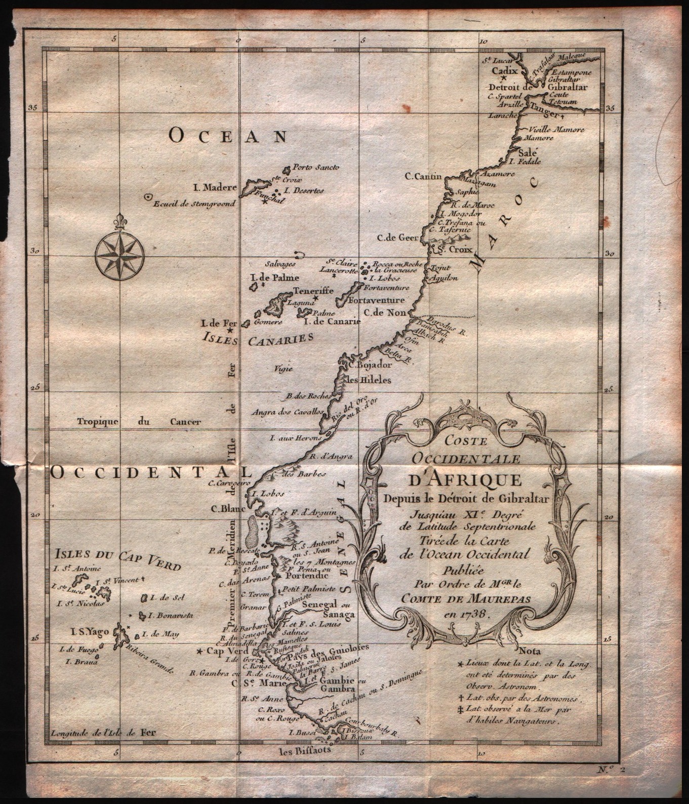
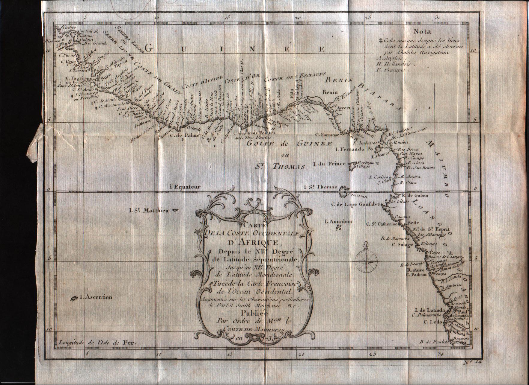
Map title
Costa occidentale d'Affrica dal XI grado di latitudine settentrionale sino al capo di Buona Speranza.
Author
Bellin
Location shown in map
West Africa
Edition date
1739
Edition place
--
Editor
--
Atlas
--
Price
Please ask: info@thetreasuremaps.com
State
[mint/excellent/VERY GOOD/good/fair/mediocre/poor]
Color
Black/white
Verso
Blank
Size
Plate: cm (25.4 x 22.9) inches (10 x 9.02) Paper: cm (26.7 x 25.4) inches (10.51 x 10)
Technique
Copper engraving
Note
The map is signed as to be printed by an order of Conte di Maurepas.
Reference
--
Wiki
Here for more info
In stock
Available
Info
info@thetreasuremaps.com
Code
#0299
×
![Costa occidentale d'Affrica dal XI grado di latitudine settentrionale sino al capo di Buona Speranza. by Bellin, West Africa, 1739]()
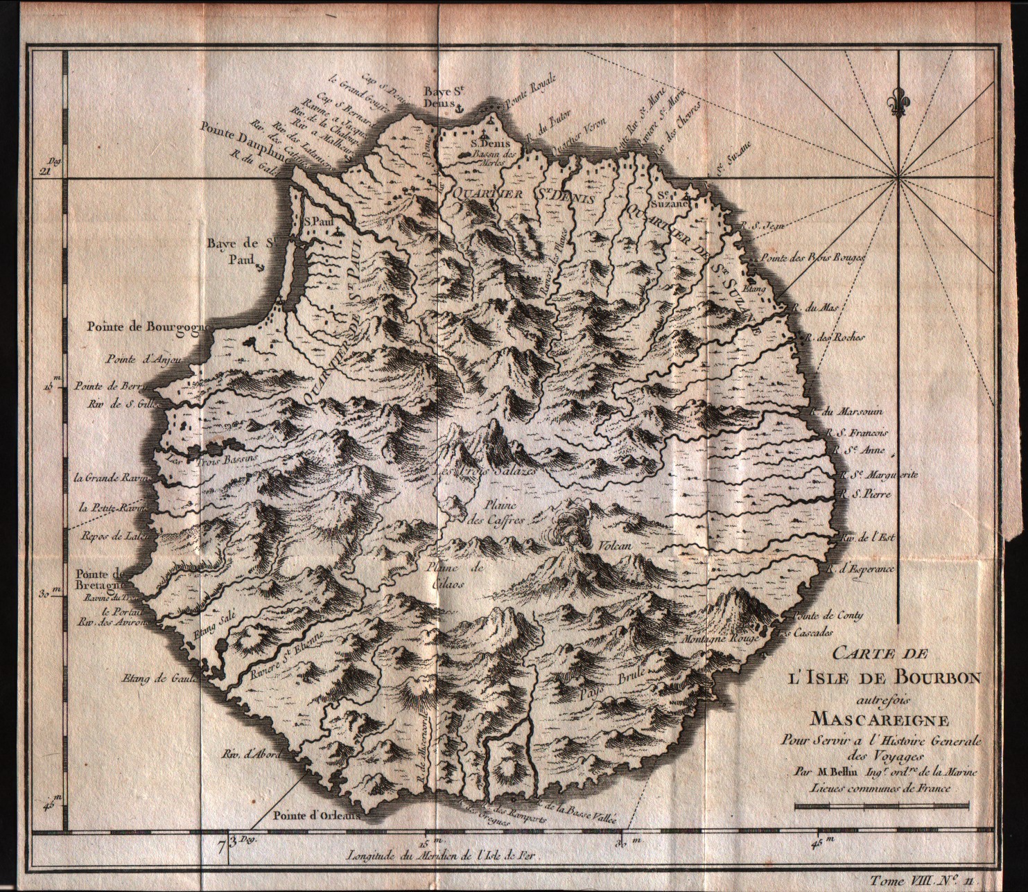
Map title
Carte de l'isle de Bourbon
Author
Bellin
Location shown in map
Reunion
Edition date
1757
Edition place
Paris
Editor
--
Atlas
Historie General des Voyages -- Prevost
Price
75 Euro
State
[mint/EXCELLENT/very good/good/fair/mediocre/poor]
Color
Black/white
Verso
Blank
Size
Plate: cm (24.1 x 20.3) inches (9.49 x 7.99) Paper: cm (24.1 x 21.6) inches (9.49 x 8.5)
Technique
Copper engraving
Note
No particular notes for this maps
Reference
--
Wiki
Here for more info
In stock
Available
Info
info@thetreasuremaps.com
Code
#0300
×
![Carte de l'isle de Bourbon by Bellin, Reunion, 1757]()
Map title
Coste occidentale d'Afrique
Author
Bellin
Location shown in map
--
Edition date
1757
Edition place
Paris
Editor
--
Atlas
Historie General des Voyages -- Prevost
Price
Please ask: info@thetreasuremaps.com
State
[mint/EXCELLENT/very good/good/fair/mediocre/poor]
Color
Black/white
Verso
Blank
Size
Plate: cm (25.4 x 24.1) inches (10 x 9.49) Paper: cm (27.9 x 25.4) inches (10.98 x 10)
Technique
Copper engraving
Note
No particular notes for this maps
Reference
--
Wiki
Here for more info
In stock
Available
Info
info@thetreasuremaps.com
Code
#0301
×
![Coste occidentale d'Afrique by Bellin, --, 1757]()
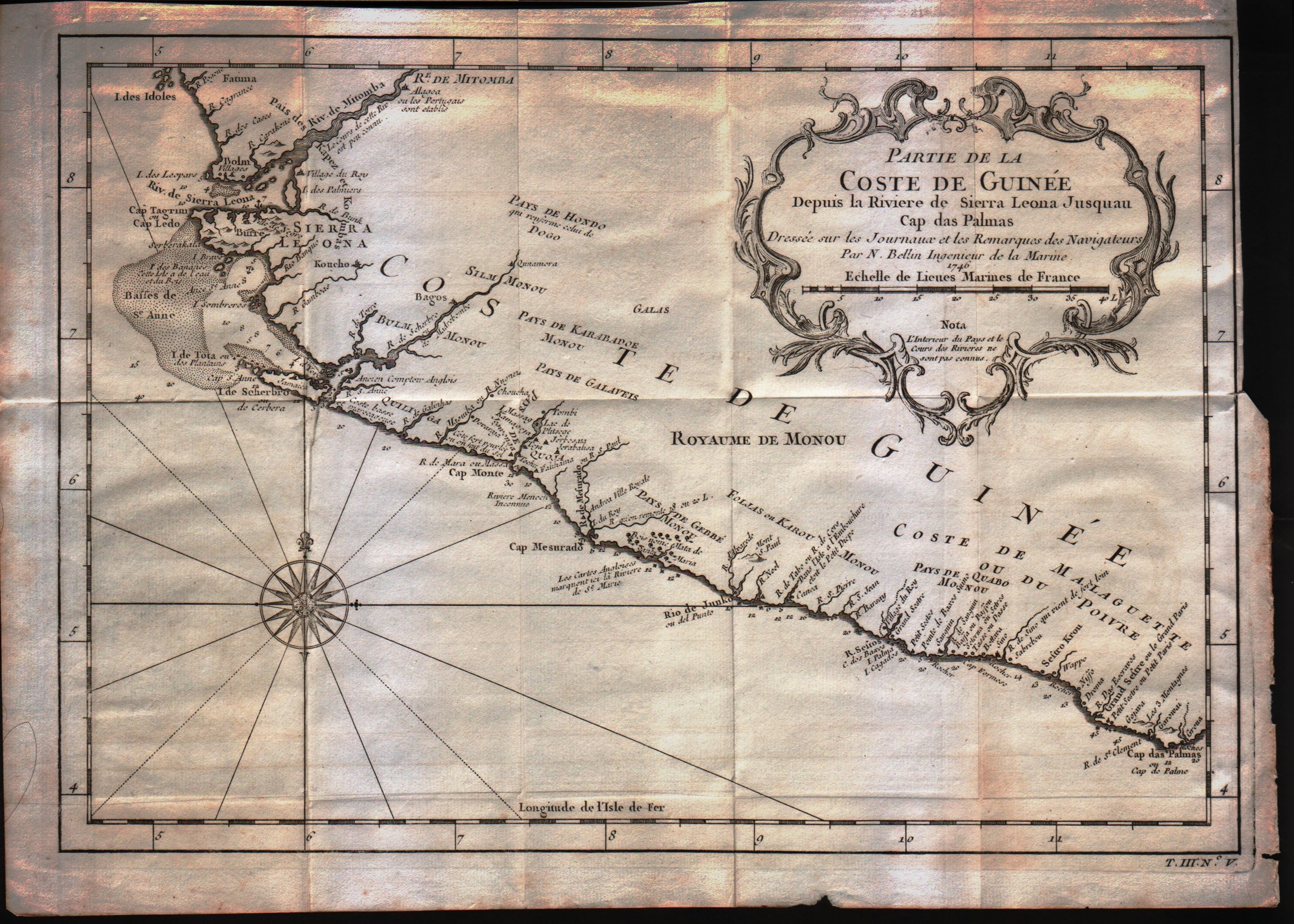
Map title
Partie de la coste de Guinee
Author
Bellin
Location shown in map
--
Edition date
1757
Edition place
Paris
Editor
--
Atlas
Historie General des Voyages -- Prevost
Price
Please ask: info@thetreasuremaps.com
State
[mint/EXCELLENT/very good/good/fair/mediocre/poor]
Color
Black/white
Verso
Blank
Size
Plate: cm (33 x 22.9) inches (12.99 x 9.02) Paper: cm (34.3 x 25.4) inches (13.5 x 10)
Technique
Copper engraving
Note
No particular notes for this maps
Reference
--
Wiki
Here for more info
In stock
Available
Info
info@thetreasuremaps.com
Code
#0302
×
![Partie de la coste de Guinee by Bellin, --, 1757]()
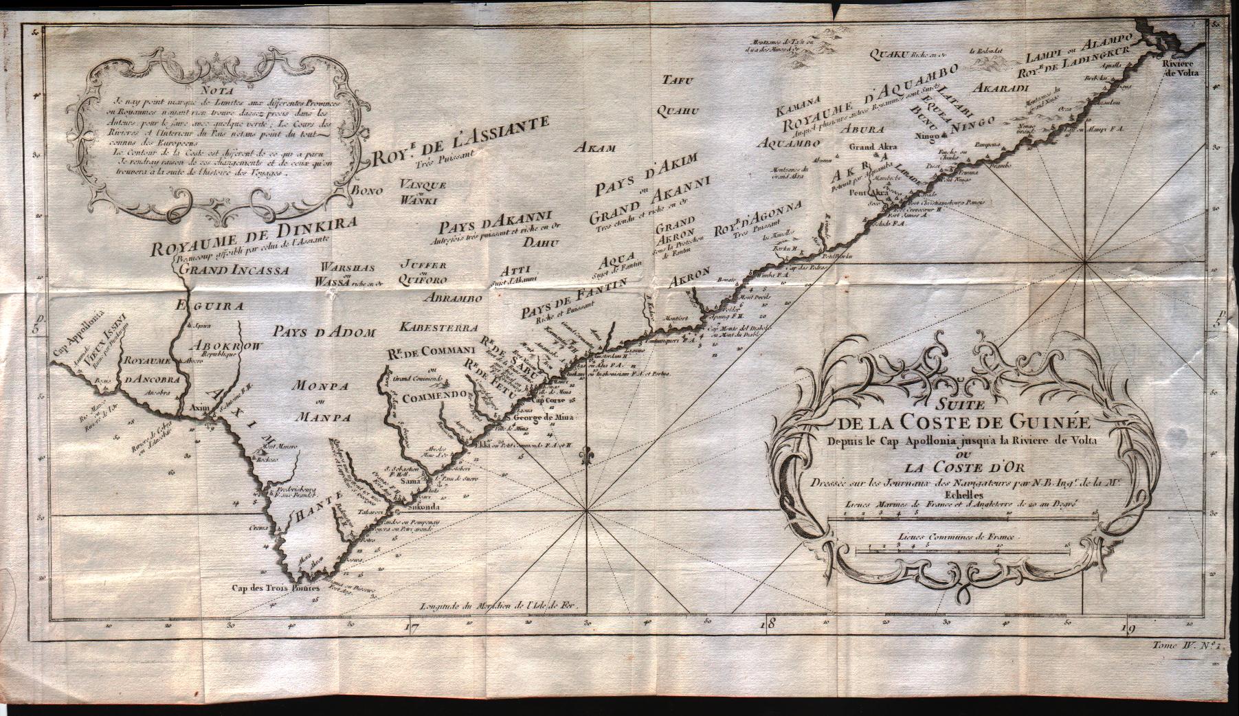
Map title
Suite de la coste de Guinee depuis le Cap Apollonia jusqua la riviere de Volta ou La Cote d'Or
Author
Bellin
Location shown in map
--
Edition date
1757
Edition place
Paris
Editor
--
Atlas
Historie General des Voyages -- Prevost
Price
Please ask: info@thetreasuremaps.com
State
[mint/EXCELLENT/very good/good/fair/mediocre/poor]
Color
Black/white
Verso
Blank
Size
Plate: cm (43.2 x 22.9) inches (17.01 x 9.02) Paper: cm (45.7 x 25.4) inches (17.99 x 10)
Technique
Copper engraving
Note
No particular notes for this maps
Reference
--
Wiki
Here for more info
In stock
Available
Info
info@thetreasuremaps.com
Code
#0303
×
![Suite de la coste de Guinee depuis le Cap Apollonia jusqua la riviere de Volta ou La Cote d'Or by Bellin, --, 1757]()
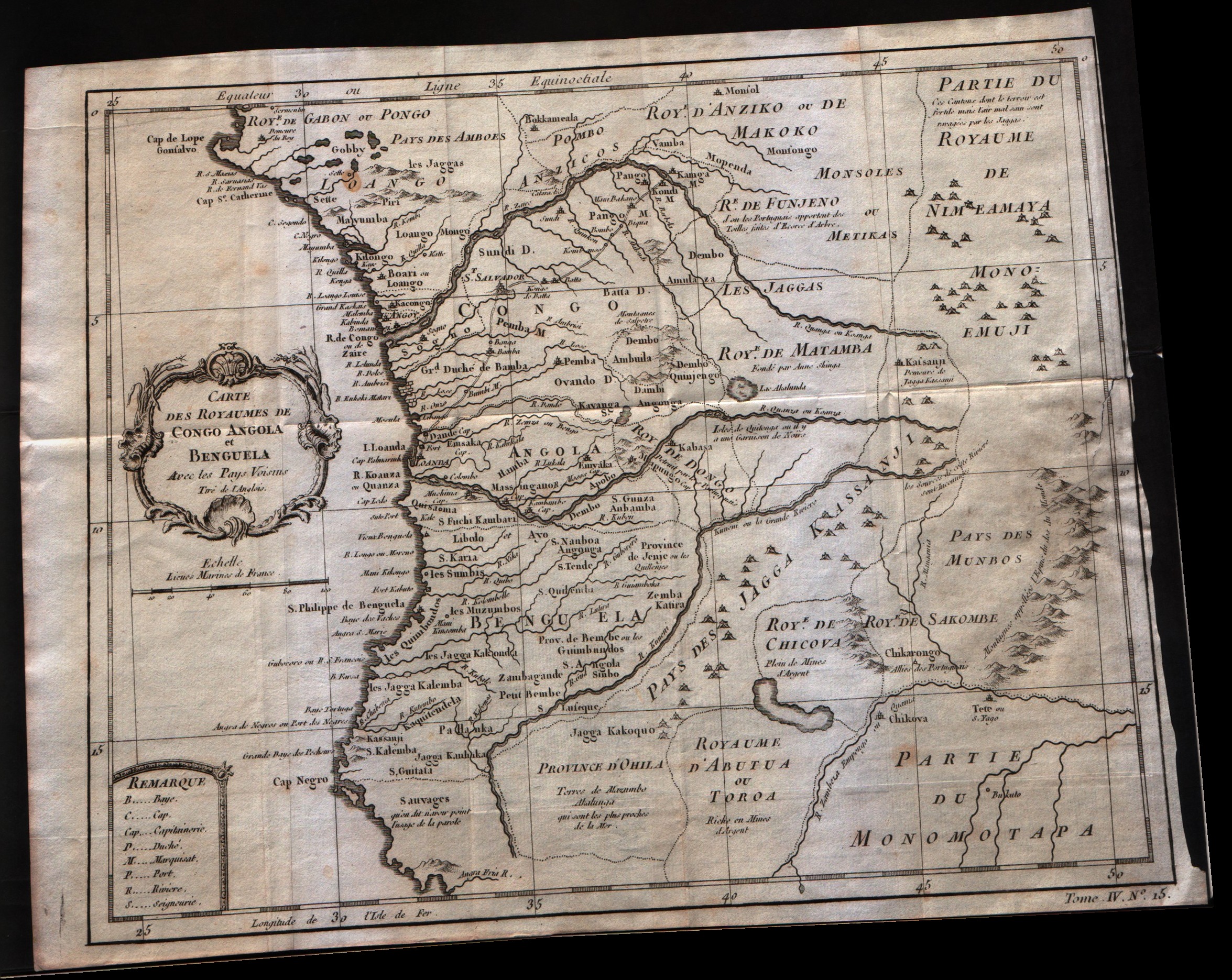
Map title
Carte Des Royaumes De Congo Angola Et Benguela
Author
Bellin
Location shown in map
--
Edition date
1757
Edition place
Paris
Editor
--
Atlas
Historie General des Voyages -- Prevost
Price
Please ask: info@thetreasuremaps.com
State
[mint/excellent/very good/GOOD/fair/mediocre/poor]
Color
Black/white
Verso
Blank
Size
Plate: cm (30.5 x 24.1) inches (12.01 x 9.49) Paper: cm (33 x 25.4) inches (12.99 x 10)
Technique
Copper engraving
Note
No particular notes for this maps
Reference
--
Wiki
Here for more info
In stock
Available
Info
info@thetreasuremaps.com
Code
#0304
×
![Carte Des Royaumes De Congo Angola Et Benguela by Bellin, --, 1757]()
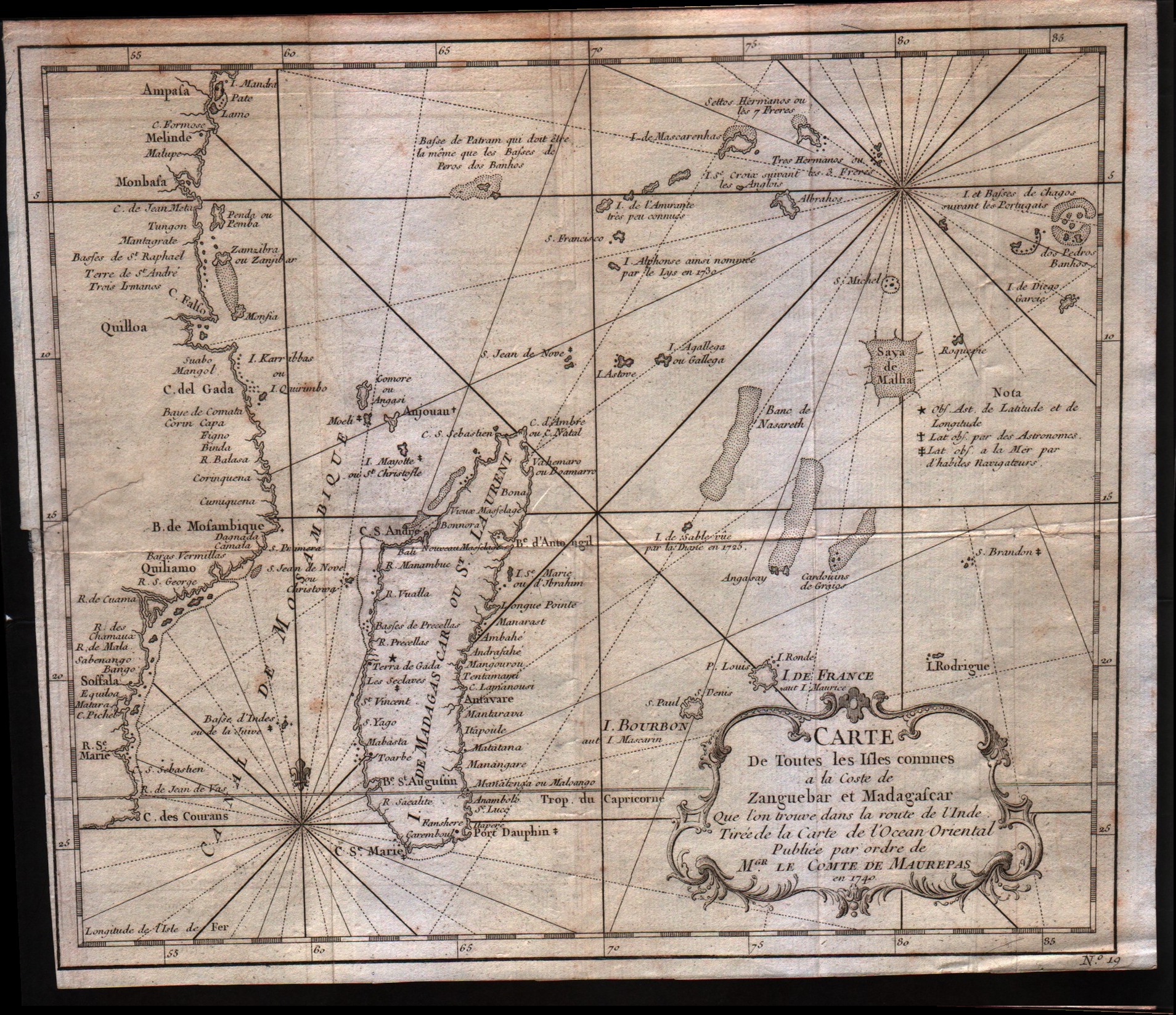
Map title
Carte de toutes les isles connues a la coste de Zanguebar at Madagascar
Author
Bellin
Location shown in map
--
Edition date
1757
Edition place
Paris
Editor
--
Atlas
Historie General des Voyages -- Prevost
Price
150 Euro
State
[mint/excellent/very good/GOOD/fair/mediocre/poor]
Color
Black/white
Verso
Blank
Size
Plate: cm (27.9 x 24.1) inches (10.98 x 9.49) Paper: cm (29.2 x 25.4) inches (11.5 x 10)
Technique
Copper engraving
Note
No particular notes for this maps
Reference
--
Wiki
Here for more info
In stock
Available
Info
info@thetreasuremaps.com
Code
#0305
×
![Carte de toutes les isles connues a la coste de Zanguebar at Madagascar by Bellin, --, 1757]()
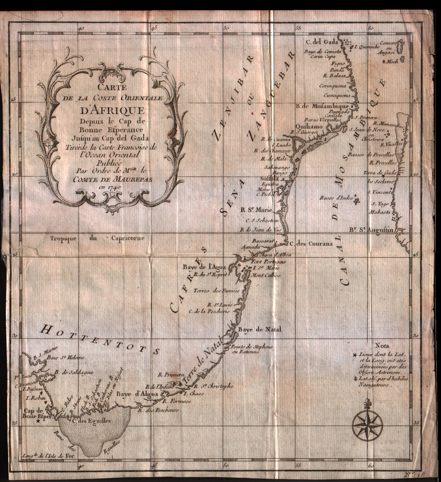
Map title
Carte de la coste Orientale d'Afrique depuis le Cap de Bonne Esperance Jusqu'au Cap del Gada
Author
Bellin
Location shown in map
--
Edition date
1757
Edition place
Paris
Editor
--
Atlas
Historie General des Voyages -- Prevost
Price
75 Euro
State
[mint/excellent/very good/GOOD/fair/mediocre/poor]
Color
Black/white
Verso
Blank
Size
Plate: cm (21.6 x 24.1) inches (8.5 x 9.49) Paper: cm (22.9 x 25.4) inches (9.02 x 10)
Technique
Copper engraving
Note
No particular notes for this maps
Reference
--
Wiki
Here for more info
In stock
Available
Info
info@thetreasuremaps.com
Code
#0306
×
![Carte de la coste Orientale d'Afrique depuis le Cap de Bonne Esperance Jusqu'au Cap del Gada by Bellin, --, 1757]()
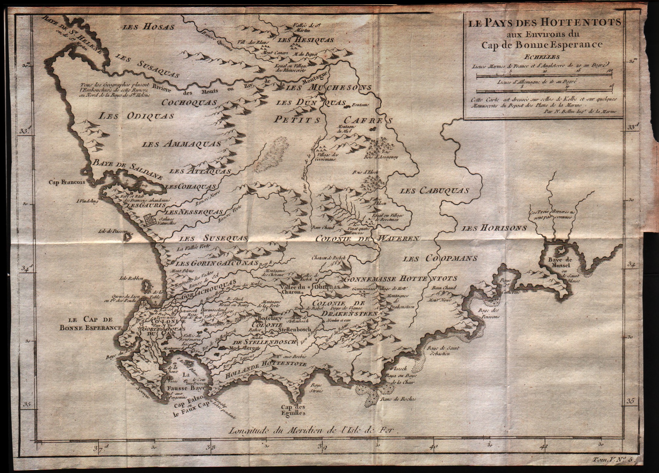
Map title
Le pays des Hottentots aux environs du Cap de Bonne Esperance
Author
Bellin
Location shown in map
--
Edition date
1757
Edition place
Paris
Editor
--
Atlas
Historie General des Voyages -- Prevost
Price
Please ask: info@thetreasuremaps.com
State
[mint/excellent/VERY GOOD/good/fair/mediocre/poor]
Color
Black/white
Verso
Blank
Size
Plate: cm (33 x 26.7) inches (12.99 x 10.51) Paper: cm (35.6 x 26.7) inches (14.02 x 10.51)
Technique
Copper engraving
Note
No particular notes for this maps
Reference
--
Wiki
Here for more info
In stock
Available
Info
info@thetreasuremaps.com
Code
#0307
×
![Le pays des Hottentots aux environs du Cap de Bonne Esperance by Bellin, --, 1757]()
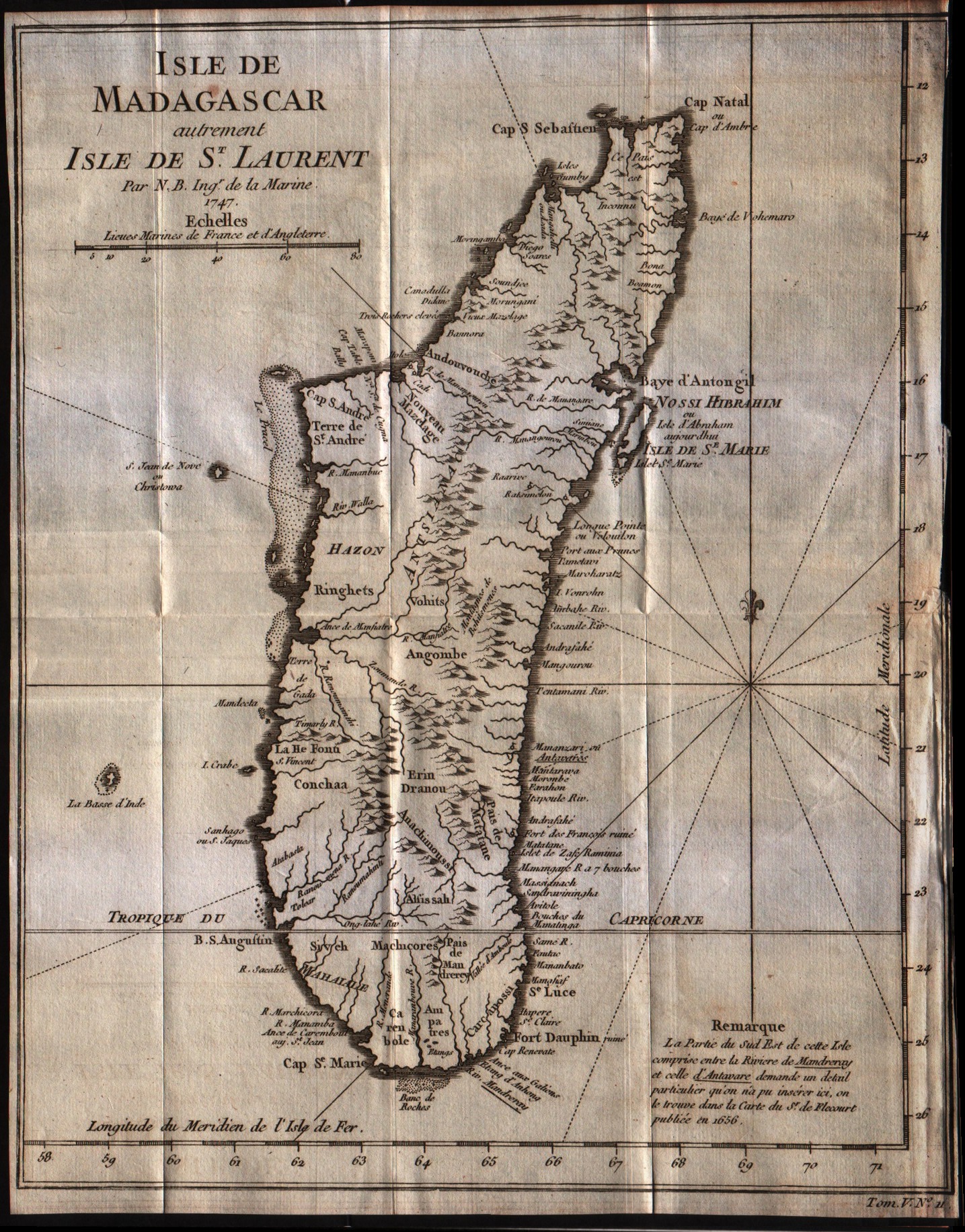
Map title
Isle de Madagascar
Author
Bellin
Location shown in map
Madagascar island
Edition date
1757
Edition place
Paris
Editor
--
Atlas
Historie General des Voyages -- Prevost
Price
125 Euro
State
[mint/excellent/VERY GOOD/good/fair/mediocre/poor]
Color
Black/white
Verso
Blank
Size
Plate: cm (22.9 x 29.2) inches (9.02 x 11.5) Paper: cm (22.9 x 30.5) inches (9.02 x 12.01)
Technique
Copper engraving
Note
No particular notes for this maps
Reference
--
Wiki
Here for more info
In stock
Available
Info
info@thetreasuremaps.com
Code
#0308
×
![Isle de Madagascar by Bellin, Madagascar island, 1757]()
Map title
Coste occidentale d'Afrique depuis le detroit de Gibraltar
Author
Bellin
Location shown in map
West Africa
Edition date
1757
Edition place
Paris
Editor
--
Atlas
Historie General des Voyages -- Prevost
Price
Please ask: info@thetreasuremaps.com
State
[mint/excellent/VERY GOOD/good/fair/mediocre/poor]
Color
Black/white
Verso
Blank
Size
Plate: cm (20.3 x 24.1) inches (7.99 x 9.49) Paper: cm (22.9 x 25.4) inches (9.02 x 10)
Technique
Copper engraving
Note
No particular notes for this maps
Reference
--
Wiki
Here for more info
In stock
Available
Info
info@thetreasuremaps.com
Code
#0309
×
![Coste occidentale d'Afrique depuis le detroit de Gibraltar by Bellin, West Africa, 1757]()
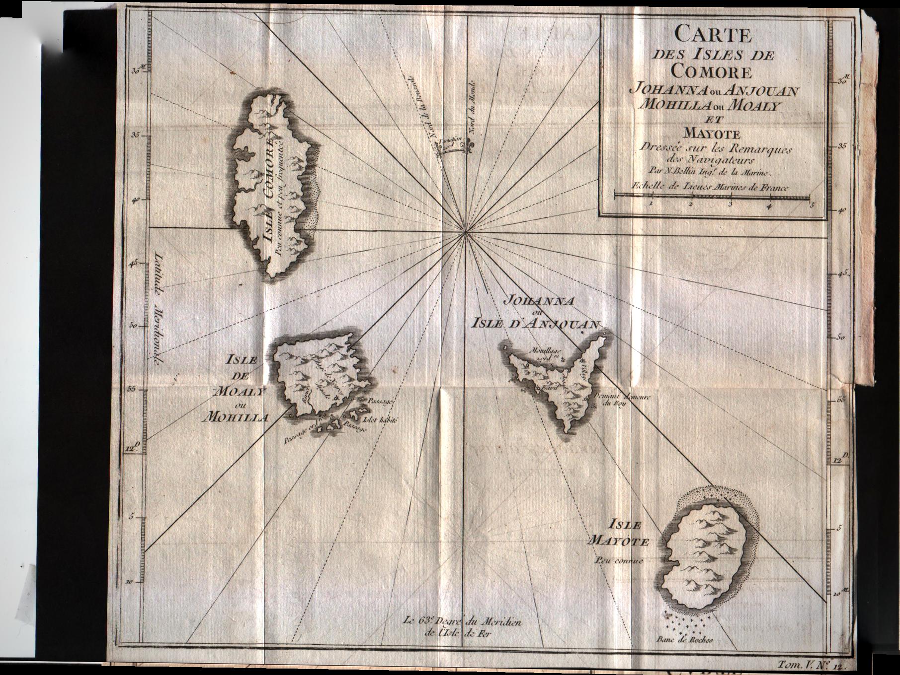
Map title
Carte des isles de Comore
Author
Bellin
Location shown in map
Comore islands
Edition date
1757
Edition place
Paris
Editor
--
Atlas
Historie General des Voyages -- Prevost
Price
75 Euro
State
[mint/excellent/VERY GOOD/good/fair/mediocre/poor]
Color
Black/white
Verso
Blank
Size
Plate: cm (25.4 x 22.9) inches (10 x 9.02) Paper: cm (25.4 x 22.9) inches (10 x 9.02)
Technique
Copper engraving
Note
No particular notes for this maps
Reference
--
Wiki
Here for more info
In stock
Available
Info
info@thetreasuremaps.com
Code
#0310
×
![Carte des isles de Comore by Bellin, Comore islands, 1757]()
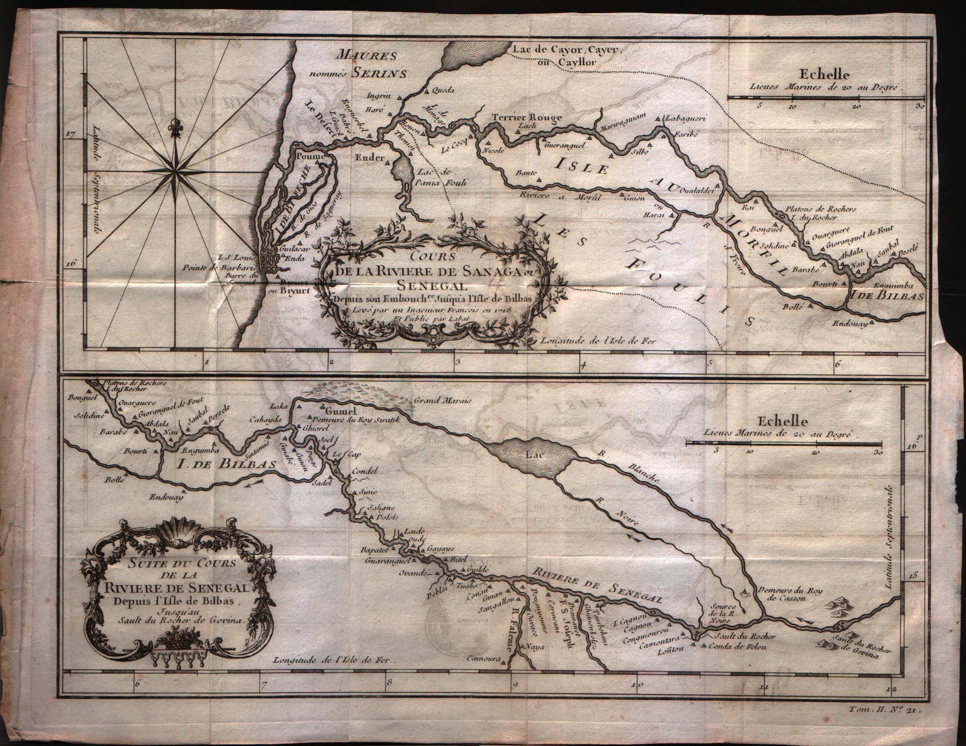
Map title
Suite du cours de la diviere de Senegal
Author
Bellin
Location shown in map
Comore islands
Edition date
1757
Edition place
Paris
Editor
--
Atlas
Historie General des Voyages -- Prevost
Price
Please ask: info@thetreasuremaps.com
State
[mint/excellent/VERY GOOD/good/fair/mediocre/poor]
Color
Black/white
Verso
Blank
Size
Plate: cm (27.9 x 22.9) inches (10.98 x 9.02) Paper: cm (31.8 x 24.1) inches (12.52 x 9.49)
Technique
Copper engraving
Note
No particular notes for this maps
Reference
--
Wiki
Here for more info
In stock
Available
Info
info@thetreasuremaps.com
Code
#0311
×
![Suite du cours de la diviere de Senegal by Bellin, Comore islands, 1757]()
Map title
Carte de la coste Occidentale d'Afrique Depuis le XII degree de latitude Septentrionale
Author
Bellin
Location shown in map
West Afrique
Edition date
1757
Edition place
Paris
Editor
--
Atlas
Historie General des Voyages -- Prevost
Price
100 Euro
State
[mint/excellent/VERY GOOD/good/fair/mediocre/poor]
Color
Black/white
Verso
Blank
Size
Plate: cm (25.4 x 20.3) inches (10 x 7.99) Paper: cm (27.9 x 22.9) inches (10.98 x 9.02)
Technique
Copper engraving
Note
No particular notes for this maps
Reference
--
Wiki
Here for more info
In stock
Available
Info
info@thetreasuremaps.com
Code
#0312
×
![Carte de la coste Occidentale d'Afrique Depuis le XII degree de latitude Septentrionale by Bellin, West Afrique, 1757]()
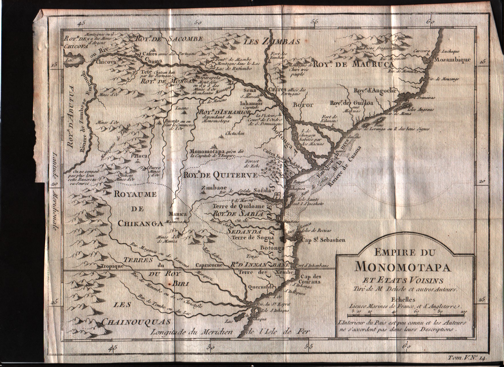
Map title
Empire du Monomotapa et etas voisins
Author
Bellin
Location shown in map
--
Edition date
1757
Edition place
Paris
Editor
--
Atlas
Historie General des Voyages -- Prevost
Price
Please ask: info@thetreasuremaps.com
State
[mint/excellent/VERY GOOD/good/fair/mediocre/poor]
Color
Black/white
Verso
Blank
Size
Plate: cm (25.4 x 20.3) inches (10 x 7.99) Paper: cm (27.9 x 21.6) inches (10.98 x 8.5)
Technique
Copper engraving
Note
No particular notes for this maps
Reference
--
Wiki
Here for more info
In stock
Available
Info
info@thetreasuremaps.com
Code
#0313
×
![Empire du Monomotapa et etas voisins by Bellin, --, 1757]()